Products
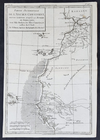
1780 Rigobert Bonne Original Antique Map NW Africa Morocco to Senegal Canary Is.
- Title : Partie Occidentale De L Ancien Continent ...M Bonne
- Size: 13in x 9 1/2in (330mm x 240mm)
- Ref #: 40900
- Date : 1780
- Condition: (A+) Fine Condition
Description:
This original copper-plate engraved map was published in 1780 edition of Atllas des toutes les parties connues du globe terrestre by Rigobert Bonne & Guillaume Raynal.
General Definitions:
Paper thickness and quality: - Heavy and stable
Paper color : - off white
Age of map color: -
Colors used: -
General color appearance: -
Paper size: - 13in x 9 1/2in (330mm x 240mm)
Plate size: - 13in x 9 1/2in (330mm x 240mm)
Margins: - Min 1/4in (8mm)
Imperfections:
Margins: - None
Plate area: - None
Verso: - None
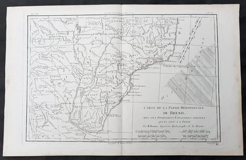
1780 Rigobert Bonne Original Antique Map of Brazil, South America
- Title : Carte de la Partie Meridionale Du Bresil....M Bonne
- Size: 15in x 10in (380mm x 255mm)
- Ref #: 31684
- Date : 1780
- Condition: (A+) Fine Condition
Description:
This original copper-plate engraved map was published in 1780 edition of Atllas des toutes les parties connues du globe terrestre by Rigobert Bonne & Guillaume Raynal.
General Definitions:
Paper thickness and quality: - Heavy and stable
Paper color : - off white
Age of map color: -
Colors used: -
General color appearance: -
Paper size: - 15in x 10in (380mm x 255mm)
Plate size: - 13in x 9in (330mm x 230mm)
Margins: - Min 1in (25mm)
Imperfections:
Margins: - None
Plate area: - None
Verso: - None
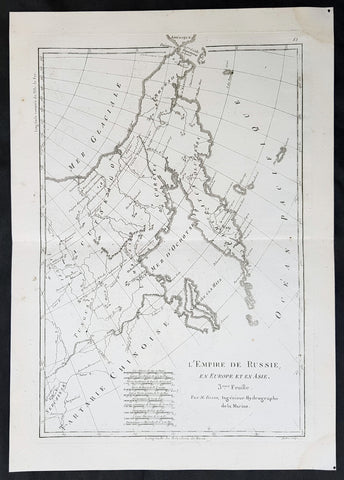
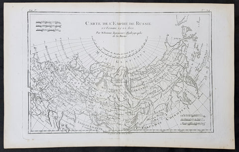
1780 Rigobert Bonne Original Antique Map of Eastern Russia, China
- Title : L Empire de Russie en Europe et an Asie...M Bonne
- Size: 15in x 10in (380mm x 255mm)
- Ref #: 40528
- Date : 1780
- Condition: (A+) Fine Condition
Description:
This original copper-plate engraved map was published in 1780 edition of Atllas des toutes les parties connues du globe terrestre by Rigobert Bonne & Guillaume Raynal.
General Definitions:
Paper thickness and quality: - Heavy and stable
Paper color : - off white
Age of map color: -
Colors used: -
General color appearance: -
Paper size: - 15in x 10in (380mm x 255mm)
Plate size: - 13in x 9in (330mm x 230mm)
Margins: - Min 1in (25mm)
Imperfections:
Margins: - None
Plate area: - None
Verso: - None
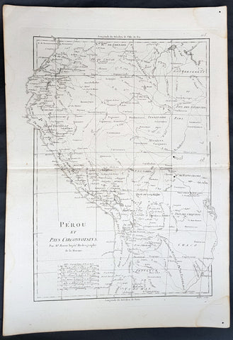
1780 Rigobert Bonne Original Antique Map of Peru, South America
- Title : Perou et Pays Circonvoisins... Par M. Bonne
- Ref #: 40551
- Size: 17in x 11 1/2in (430mm x 290mm)
- Date : 1780
- Condition: (A+) Fine Condition
Description:
This fine original antique map of French & Dutch Guyana, South America by Rigobert Bonne was published in the 1780 edition of Atlas des toutes les parties connues du globe terrestre by Guillaume Raynal. (Ref Tooley M&B)
General Description:
Paper thickness and quality: - Heavy and stable
Paper color: - White
Age of map color: -
Colors used: -
General color appearance: -
Paper size: - 17in x 11 1/2in (430mm x 290mm)
Plate size: - 14 1/2in x 10 1/2in (370mm x 265mm)
Margins: - Min 1in (25mm)
Imperfections:
Margins: - None
Plate area: - None
Verso: - None
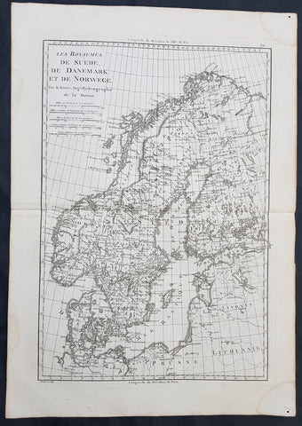
1780 Rigobert Bonne Original Antique Map of Scandinavia Sweden, Norway & Denmark
- Title : Les Royaumes De Suede De Denmark et de Norwege
- Size: 16in x 11in (405mm x 2805mm)
- Ref #: 40525
- Date : 1780
- Condition: (A+) Fine Condition
Description:
This fine original copper-plate engraved antique map of Scandinavia, Sweden, Norwaty and Denmark was published in 1780 edition of Atlas des toutes les parties connues du globe terrestre by Rigobert Bonne & Guillaume Raynal.
General Definitions:
Paper thickness and quality: - Heavy and stable
Paper color : - off white
Age of map color: -
Colors used: -
General color appearance: -
Paper size: - 16in x 11in (405mm x 2805mm)
Plate size: - 14in x 10in (355mm x 255mm)
Margins: - Min 1/2in (12mm)
Imperfections:
Margins: - None
Plate area: - None
Verso: - None
1780 Rigobert Bonne Original Antique Map of The Russian Empire
- Title : Carte De L Empire de Russie en Europe et en Asie...M Bonne
- Size: 15in x 10in (380mm x 255mm)
- Ref #: 31674
- Date : 1780
- Condition: (A+) Fine Condition
Description:
This original copper-plate engraved map was published in 1780 edition of Atllas des toutes les parties connues du globe terrestre by Rigobert Bonne & Guillaume Raynal.
General Definitions:
Paper thickness and quality: - Heavy and stable
Paper color : - off white
Age of map color: -
Colors used: -
General color appearance: -
Paper size: - 15in x 10in (380mm x 255mm)
Plate size: - 13in x 9in (330mm x 230mm)
Margins: - Min 1in (25mm)
Imperfections:
Margins: - None
Plate area: - None
Verso: - None
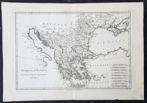
1780 Rigobert Bonne Original Antique Map of Turkey in Europe - Greece to Hungary
- Title : Turquie D Europe...M Bonne
- Size: 15in x 10in (380mm x 255mm)
- Ref #: 40526
- Date : 1780
- Condition: (A+) Fine Condition
Description:
This original copper-plate engraved map was published in 1780 edition of Atllas des toutes les parties connues du globe terrestre by Rigobert Bonne & Guillaume Raynal.
General Definitions:
Paper thickness and quality: - Heavy and stable
Paper color : - off white
Age of map color: -
Colors used: -
General color appearance: -
Paper size: - 15in x 10in (380mm x 255mm)
Plate size: - 13in x 9in (330mm x 230mm)
Margins: - Min 1in (25mm)
Imperfections:
Margins: - None
Plate area: - None
Verso: - None
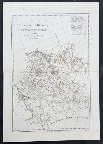
1780 Rigobert Bonne Original Antique Map of Western, European Russia, Poland
- Title : L Empire de Russie en Europe et an Asie...M Bonne
- Size: 15in x 10in (380mm x 255mm)
- Ref #: 40527
- Date : 1780
- Condition: (A+) Fine Condition
Description:
This original copper-plate engraved map was published in 1780 edition of Atllas des toutes les parties connues du globe terrestre by Rigobert Bonne & Guillaume Raynal.
General Definitions:
Paper thickness and quality: - Heavy and stable
Paper color : - off white
Age of map color: -
Colors used: -
General color appearance: -
Paper size: - 15in x 10in (380mm x 255mm)
Plate size: - 13in x 9in (330mm x 230mm)
Margins: - Min 1in (25mm)
Imperfections:
Margins: - None
Plate area: - None
Verso: - None
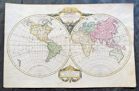
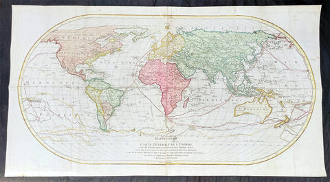
1780 Robert De Vaugondy Antique Twin Hemisphere World Map
Antique Map
- Title : Mappe-Monde par Robert de Vaugondy Geographe ord du Roi
- Size: 17 1/2in x 11 1/2in (440mm x 290mm)
- Condition: (A+) Fine Condition
- Date : 1780
- Ref #: 17060
Description:
This beautifully hand coloured original copper-plate engraved antique Twin Hemisphere World Map by Robert De Vaugondy was engraved in 1780 - dated in title and published in the same year.
General Definitions:
Paper thickness and quality: - Heavy and stable
Paper color : - off white
Age of map color: - Original
Colors used: - Yellow, green, blue, pink
General color appearance: - Authentic
Paper size: - 17 1/2in x 11 1/2in (440mm x 290mm)
Plate size: - 17 1/2in x 11 1/2in (440mm x 290mm)
Margins: - Min 1/2in (12mm)
Imperfections:
Margins: - None
Plate area: - None
Verso: - None
Background:
Fine twin hemisphere world map illustrating the known world in the 18th century. Although almost complete there are a few regions of uncertainty. The route taken by Cook on his final voyage is included which reaches from Australia, New Zealand to Hawaii and the very northern reaches of western North America which were surveyed and mapped by Cook extensively. There is some indication of a northern Arctic region there is no mention of the great southern Antarctica regions. A great map showing the world at the beginning of modern era. (Ref: Tooley; M&B)
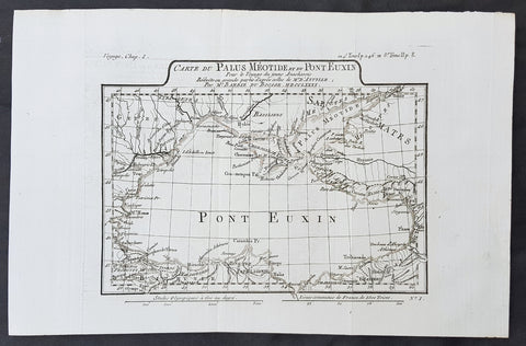
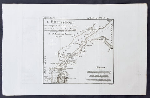
1781 Du Bocage & Barthelemy Original Antique Map of The Black Sea, Anacharsis Yr
- Title : Carte Du Palus Meotide et du Pont Euxin Pour le Voyage du Jeune Anacharsis....MDCCLXXXI
- Size: 15in x 10in (380mm x 255mm)
- Ref #: 16467
- Date : 1781
- Condition: (A+) Fine Condition
Description:
This original copper-plate engraved map by Jean Denis Barbie du Bocage was engraved in 1781 - dated in the title - and was published in the 1787 edition of Jean-Jacques Barthelemy famous Voyage du jeune Anarcharsis en Grece or Travels of Anacharsis the younger in Greece in 4 volumes.
General Definitions:
Paper thickness and quality: - Heavy and stable
Paper color : - off white
Age of map color: -
Colors used: -
General color appearance: -
Paper size: - 15in x 10in (380mm x 255mm)
Plate size: - 11in x 8 1/2in (280mm x 215mm)
Margins: - Min 1in (25mm)
Imperfections:
Margins: - None
Plate area: - Folds as issued
Verso: - None
Background:
Jean-Jacques Barthelemy 1716 – 1795 was a French writer and numismatist.
Barthelemy was the author of a number of learned works on antiquarian subjects, but the great work on which his fame rests is Travels of Anacharsis the younger in Greece (French: Voyage du jeune Anarcharsis en Grece, 4 vols., 1787). He had begun it in 1757 and had been working on it for thirty years. The hero, a young Scythian descended from the famous philosopher Anacharsis, is supposed to repair to Greece for instruction in his early youth, and after making the tour of her republics, colonies and islands, to return to his native country and write this book in his old age, after the Macedonian hero had overturned the Persian empire. In the manner of modern travellers, he gives an account of the customs, government, and antiquities of the country he is supposed to have visited. A copious introduction supplies whatever may be wanting in respect to historical details, while various dissertations on the music of the Greeks, on the literature of the Athenians, and on the economy, pursuits, ruling passions, manners, and customs of the surrounding states supply ample information on the subjects of which they treat.
Modern scholarship has superseded most of the details in the Voyage, but the author himself did not imagine his book to be a register of accurately ascertained facts. Rather, he intended to afford to his countrymen, in an interesting form, some knowledge of Greek civilisation. The Charicles, or Illustrations of the Private Life of the Ancient Greeks of Wilhelm Adolf Becker is an attempt in a similar direction
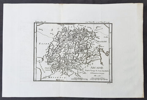
1782 Du Bocage & Barthelemy Antique Map of Arcadia Peloponnese, Greece - Tripoli
- Title : l Arcadie, Pour le Voyage du Jeune Anacharsis......1786
- Size: 15in x 10in (380mm x 255mm)
- Ref #: 16448
- Date : 1786
- Condition: (A+) Fine Condition
Description:
This original copper-plate engraved map by Jean Denis Barbie du Bocage was engraved in 1786 - dated in the title - and was published in the 1787 edition of Jean-Jacques Barthelemy famous Voyage du jeune Anarcharsis en Grece or Travels of Anacharsis the younger in Greecein 4 volumes.
General Definitions:
Paper thickness and quality: - Heavy and stable
Paper color : - off white
Age of map color: -
Colors used: -
General color appearance: -
Paper size: - 15in x 10in (380mm x 255mm)
Plate size: - 12in x 8 1/2in (305mm x 215mm)
Margins: - Min 1in (25mm)
Imperfections:
Margins: - None
Plate area: - Folds as issued
Verso: - None
Background:
Jean-Jacques Barthelemy 1716 – 1795 was a French writer and numismatist.
Barthelemy was the author of a number of learned works on antiquarian subjects, but the great work on which his fame rests is Travels of Anacharsis the younger in Greece (French: Voyage du jeune Anarcharsis en Grece, 4 vols., 1787). He had begun it in 1757 and had been working on it for thirty years. The hero, a young Scythian descended from the famous philosopher Anacharsis, is supposed to repair to Greece for instruction in his early youth, and after making the tour of her republics, colonies and islands, to return to his native country and write this book in his old age, after the Macedonian hero had overturned the Persian empire. In the manner of modern travellers, he gives an account of the customs, government, and antiquities of the country he is supposed to have visited. A copious introduction supplies whatever may be wanting in respect to historical details, while various dissertations on the music of the Greeks, on the literature of the Athenians, and on the economy, pursuits, ruling passions, manners, and customs of the surrounding states supply ample information on the subjects of which they treat.
Modern scholarship has superseded most of the details in the Voyage, but the author himself did not imagine his book to be a register of accurately ascertained facts. Rather, he intended to afford to his countrymen, in an interesting form, some knowledge of Greek civilisation. The Charicles, or Illustrations of the Private Life of the Ancient Greeks of Wilhelm Adolf Becker is an attempt in a similar direction
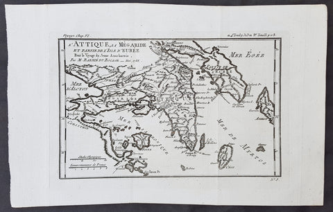
1782 Du Bocage & Barthelemy Antique Map of Attica Megaris Thebes Euboea, Greece
- Title : l Attique, la Megaride et partie de l Isle d Eubee, Pour le Voyage du Jeune Anacharsis.....1785
- Size: 15in x 10in (380mm x 255mm)
- Ref #: 16463
- Date : 1785
- Condition: (A+) Fine Condition
Description:
This original copper-plate engraved map by Jean Denis Barbie du Bocage was engraved in 1785 - dated in the title - and was published in the 1787 edition of Jean-Jacques Barthelemy famous Voyage du jeune Anarcharsis en Grece or Travels of Anacharsis the younger in Greecein 4 volumes.
General Definitions:
Paper thickness and quality: - Heavy and stable
Paper color : - off white
Age of map color: -
Colors used: -
General color appearance: -
Paper size: - 15in x 10in (380mm x 255mm)
Plate size: - 8 1/2in x 7 1/2in (215mm x 185mm)
Margins: - Min 1in (25mm)
Imperfections:
Margins: - None
Plate area: - Folds as issued
Verso: - None
Background:
Jean-Jacques Barthelemy 1716 – 1795 was a French writer and numismatist.
Barthelemy was the author of a number of learned works on antiquarian subjects, but the great work on which his fame rests is Travels of Anacharsis the younger in Greece (French: Voyage du jeune Anarcharsis en Grece, 4 vols., 1787). He had begun it in 1757 and had been working on it for thirty years. The hero, a young Scythian descended from the famous philosopher Anacharsis, is supposed to repair to Greece for instruction in his early youth, and after making the tour of her republics, colonies and islands, to return to his native country and write this book in his old age, after the Macedonian hero had overturned the Persian empire. In the manner of modern travellers, he gives an account of the customs, government, and antiquities of the country he is supposed to have visited. A copious introduction supplies whatever may be wanting in respect to historical details, while various dissertations on the music of the Greeks, on the literature of the Athenians, and on the economy, pursuits, ruling passions, manners, and customs of the surrounding states supply ample information on the subjects of which they treat.
Modern scholarship has superseded most of the details in the Voyage, but the author himself did not imagine his book to be a register of accurately ascertained facts. Rather, he intended to afford to his countrymen, in an interesting form, some knowledge of Greek civilisation. The Charicles, or Illustrations of the Private Life of the Ancient Greeks of Wilhelm Adolf Becker is an attempt in a similar direction
1782 Du Bocage & Barthelemy Antique Map of The Dardanelles, Turkey - Hellespont
- Title : L Helles-Pont...1782
- Size: 15in x 10in (380mm x 255mm)
- Ref #: 16467
- Date : 1782
- Condition: (A+) Fine Condition
Description:
This original copper-plate engraved map by Jean Denis Barbie du Bocage was engraved in 1782 - dated in the title - and was published in the 1787 edition of Jean-Jacques Barthelemy famous Voyage du jeune Anarcharsis en Grece or Travels of Anacharsis the younger in Greecein 4 volumes.
General Definitions:
Paper thickness and quality: - Heavy and stable
Paper color : - off white
Age of map color: -
Colors used: -
General color appearance: -
Paper size: - 15in x 10in (380mm x 255mm)
Plate size: - 8 1/2in x 7 1/2in (215mm x 185mm)
Margins: - Min 1in (25mm)
Imperfections:
Margins: - None
Plate area: - Folds as issued
Verso: - None
Background:
Jean-Jacques Barthelemy 1716 – 1795 was a French writer and numismatist.
Barthelemy was the author of a number of learned works on antiquarian subjects, but the great work on which his fame rests is Travels of Anacharsis the younger in Greece (French: Voyage du jeune Anarcharsis en Grece, 4 vols., 1787). He had begun it in 1757 and had been working on it for thirty years. The hero, a young Scythian descended from the famous philosopher Anacharsis, is supposed to repair to Greece for instruction in his early youth, and after making the tour of her republics, colonies and islands, to return to his native country and write this book in his old age, after the Macedonian hero had overturned the Persian empire. In the manner of modern travellers, he gives an account of the customs, government, and antiquities of the country he is supposed to have visited. A copious introduction supplies whatever may be wanting in respect to historical details, while various dissertations on the music of the Greeks, on the literature of the Athenians, and on the economy, pursuits, ruling passions, manners, and customs of the surrounding states supply ample information on the subjects of which they treat.
Modern scholarship has superseded most of the details in the Voyage, but the author himself did not imagine his book to be a register of accurately ascertained facts. Rather, he intended to afford to his countrymen, in an interesting form, some knowledge of Greek civilisation. The Charicles, or Illustrations of the Private Life of the Ancient Greeks of Wilhelm Adolf Becker is an attempt in a similar direction
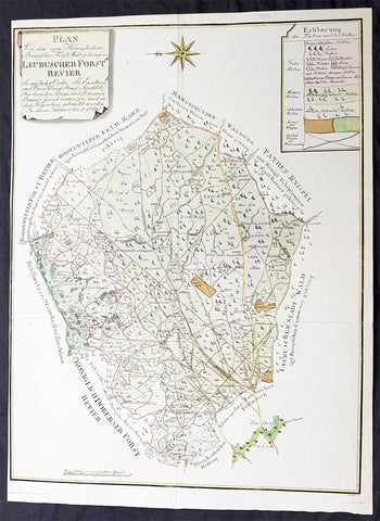
1782 G F Frentzel Large Rare Antique Map of Lubsza Forest Brzeg, Opole SW Poland
Antique Map
- Title : Plan Von Dem zum Koniglichen Briegischen Forfst Amt gehorigen Leubuscher Forst RevierSo Auf hoher Ordre Sr Excellence und Einer Konig Prussia Hochlob Breslauischen Krieges und Domainen Cammer special vermessen und in diese Proportion gebracht worden In denen Jahren 1782 et 1783
- Ref #: 93489
- Size: 21in x 16in (530mm x 415mm)
- Date : 1782-83
- Condition: (A+) Fine Condition
Description:
This incredibly rare detailed original hand coloured copper plate engraved antique map, a survey of the forest near Lubsza in the county of Brzeg in the Opole Province in SW Poland between 1782 & 1783 was engraved by the Leipzig engraver Georg Friedrich Jonas Frentzel.
General Definitions:
Paper thickness and quality: - Heavy and stable
Paper color : - off white
Age of map color: - Original
Colors used: - Green, yellow, brown, pink
General color appearance: - Authentic
Paper size: - 21in x 16in (530mm x 415mm)
Plate size: - 21in x 16in (530mm x 415mm)
Margins: - Min 1/8in (2mm)
Imperfections:
Margins: - Left margin cropped close to border
Plate area: - None
Verso: - None
Background:
Lubsza is a village in Brzeg, Opole Voivodeship, in south-western Poland. It is the seat of the gmina (administrative district) called Gmina Lubsza. It lies approximately 7 kilometres north-east of Brzeg and 41 km north-west of the regional capital Opole. Before 1945 the area was part of Germany
Frentzel, Georg Friedrich Jonas 1754 - 1799
Frentzel was a master-engraver from Leipzig in Germany, specialising in copper engraving. His work was known for its critical level of detail, cumulating in one of the finest revolutionary maps of Boston in 1776 Carte von dem Hafen und der Stadt Boston

1782 J B D Anville Large Antique Map of Western Roman Europe, Britain to Italy
- Title : Germanie, France, Italie, Espagne, Isles Britanniques...Par Le Sr D Anville...MDCCLXXXII
- Size: 27in x 20in (585mm x 510mm)
- Condition: (A) Very Good Condition
- Date : 1782
- Ref #: 92646
Description:
This large hand coloured original copper-plate engraved antique map of Western Roman Britain by Jean Baptiste Bourguignon D\'Anville was engraved in 1782 - dated in the tile cartouche - and was published in Jean-Baptiste Bourguinon D\'Anvilles large elephant folio atlas Atlas Generale. (Ref: Tooley, M&B)
General Definitions:
Paper thickness and quality: - Heavy and stable
Paper color : - off white
Age of map color: -
Colors used: -
General color appearance: -
Paper size: - 27in x 20in (585mm x 510mm)
Plate size: - 21in x 19 1/2in (535mm x 495mm)
Margins: - Min 1in (25mm)
Imperfections:
Margins: - None
Plate area: - Vertical & horizontal folds
Verso: - None
Background:
The Roman Empire was the post-Roman Republic period of the ancient Roman civilization, with a government headed by emperors and large territorial holdings around the Mediterranean Sea in Europe, Africa and Asia. The city of Rome was the largest city in the world c. 100 BC – c. AD 400, with Constantinople (New Rome) becoming the largest around AD 500, and the Empire\'s population grew to an estimated 50 to 90 million inhabitants (roughly 20% of the world\'s population at the time) The 500-year-old republic which preceded it had been severely destabilized in a series of civil wars and political conflict, during which Julius Caesar was appointed as perpetual dictator and then assassinated in 44 BC. Civil wars and executions continued, culminating in the victory of Octavian, Caesar\'s adopted son, over Mark Antony and Cleopatra at the Battle of Actium in 31 BC and the annexation of Egypt. Octavian\'s power was then unassailable and in 27 BC the Roman Senate formally granted him overarching power and the new title Augustus, effectively marking the end of the Roman Republic.
1782 Matthaus Lotter Large World Map Tracking of Cooks Voyages 1768, 1772 & 1776
Antique Map
- Title : Mappe Monde ou carte generale de l`Univers sur une projection nouvelle d`une sphere ovale pour mieux entendre les distances entre l`Europe et Amerique avec le tour du monde du Lieut Cook et Tous Les Decouvertes Nouvelles...MDCCLXXXII
- Date : 1782 (2nd edition)
- Condition: (A) Very Good Condition
- Ref: 35646
- Size: 38 1/2in x 21in (985mm x 535mm)
Description:
This very large, impressive original copper-plate engraved antique World Map, on an Ortelius Oval Projection, was engraved and published by Matthäus Albrecht Lotter in 1782, dated in title.
The map was first issued in 1778 and re-issued in 1782 & 1787 and included all three of Cooks voyages of discovery.
This map was one of the first world maps published to cash in on the publicity over Captain James Cooks Circumnavigation of the world and the first European survey of New Zealand and the East Coast of Australia. Beautifully executed and dominated by New Holland, Australia, for the first time almost complete on a world map.
General Definitions:
Paper thickness and quality: - Heavy and stable
Paper color : - off white
Age of map color: - Original
Colors used: - Yellow, green, pink
General color appearance: - Authentic
Paper size: - 38 1/2in x 21in (985mm x 535mm)
Plate size: - 37 1/2in x 19 1/4in (955mm x 495mm)
Margins: - Min 1in (25mm)
Imperfections:
Margins: - Folds as issue, light soiling
Plate area: - Folds as issue, light soiling
Verso: - Folds as issue, light soiling
Background:
This large world map was one of the first to show the discoveries of the east coast of Australia and New Zealand by James Cook on his first voyage of Discovery. The shadow line from Tasmania west to Western Australia was not filled in until the later discoveries of Bass Strait by Bass and Matthew Flinders in 1797 and the southern coast by Baudin and Flinders in 1803. Also included along the New Holland coastline is the earlier Dutch discoveries of Hartog 1616, the van Leeuwin 1619, Nuyts 1627, de Wit 1628 and Tasman 1642-44. The Trial Islands near present-day Dampier, named after the English ship the Trial, which were incorrectly charted by Gerritsz after the false reports provided by Captain Brookes, are also noted.
Cooks First Voyage (1768-1771)
The first voyage under Captain James Cook\\\\\\\'s command was primarily of a scientific nature. The expedition on the Endeavour initially sailed to Tahiti to observe the transit of the planet Venus in order to calculate the earth\\\\\\\'s distance from the sun. Cook landed on the South Pacific island in April of 1769 and in June of that year the astronomical observations were successfully completed. In addition to these labors, very good relations with the Tahitians were maintained and the naturalists Joseph Banks and Daniel C. Solander conducted extensive ethnological and botanical research.
Another purpose of the voyage was to explore the South Seas to determine if an inhabitable continent existed in the mid-latitudes of the Southern Hemisphere. Upon leaving Tahiti, Cook named and charted the Society Islands and then continued southwest to New Zealand. His circumnavigation and exploration of that country also resulted in a detailed survey. Cook proceeded to Australia, where he charted the eastern coast for 2,000 miles, naming the area New South Wales. As a result of these surveys, both Australia and New Zealand were annexed by Great Britain. In addition to these explorations, the Endeavour returned to England without a single death from scurvy among its men, an historic feat at the time. The combination of these accomplishments brought Cook prominence, promotion, and the opportunity to lead further expeditions.
Cooks Second Voyage (1772-1775)
Based on the success of his first voyage, Cook was appointed by the Admiralty to lead a second expedition. Two ships were employed with Cook commanding the Resolution and Captain Tobias Furneaux in charge of the Adventure. The purpose was to circumnavigate the globe as far south as possible to confirm the location of a southern continent. Cook proved that there was no Terra Australis, which supposedly was located between New Zealand and South America. Cook was convinced, however, that there was land beyond the southern ice fields. In his pursuit of this idea, this expedition was the first European voyage to cross the Antarctic Circle. In addition, in two great sweeps through the Southern latitudes, Cook made an incredible number of landfalls including New Zealand, Easter Island, the Marquesas, Tahiti and the Society Islands, the Tonga Islands, the New Hebrides, New Caledonia, and a number of smaller islands.
In addition to these navigational accomplishments and the accompanying expansion of geographical knowledge, the expedition also recorded a vast amount of information regarding the Pacific islands and peoples, proved the value of the chronometer as an instrument for calculating longitude, and improved techniques for preventing scurvy.
Cooks Third Voyage (1776-1779)
In the course of his first two voyages, Cook circumnavigated the globe twice, sailed extensively into the Antarctic, and charted coastlines from Newfoundland to New Zealand. Following these achievements, Cooks third voyage was organized to seek an efficient route from England to southern and eastern Asia that would not entail rounding the Cape of Good Hope. The search for such a Northwest (or Northeast) Passage had been on the agenda of northern European mariners and merchants since the beginning of European expansion in the late fifteenth century. England\\\\\\\'s growing economic and colonial interests in India in the later eighteenth century provided the stimulus for the latest exploration for this route.
Cook, again in command of the Resolution, was to approach the Northwest Passage from the Pacific accompanied by a second ship, the Discovery, captained by Charles Clerke. The ships left England separately, regrouped at Cape Town, and continued on to Tasmania, New Zealand, and Tahiti. The expedition then sailed north and made landfall at Christmas Island and the Hawaiian Islands. Cook continued northward and charted the west coast of North America from Northern California as far as the Bering Strait. He returned to Hawaii for the winter and was killed in a skirmish with natives on February 14, 1779. Upon Cooks death, Clerke took command of the expedition but died six months later. The ships returned to England in 1780 under John Gore, who had commanded the Discovery after Cooks death. From start to finish, the voyage had lasted more than four years. (Ref Tooley; M&B; Clancy)
The Ortelius Oval Projection is a map projection used for world maps largely in the late 16th and early 17th century. It is neither conformal nor equal-area but instead offers a compromise presentation. It is similar in structure to a pseudocylindrical projection but does not qualify as one because the meridians are not equally spaced along the parallels. The projection\'s first known use was by Battista Agnese (flourished 1535–1564) around 1540, although whether the construction method was truly identical to Ortelius\'s or not is unclear because of crude drafting and printing. The front hemisphere is identical to Petrus Apianus\'s 1524 globular projection.
The projection reached a wide audience via the popular map Typus Orbis Terrarum by Abraham Ortelius beginning in 1570. The projection (and indeed Ortelius maps) were widely copied by other mapmakers such as Giovanni Pietro Maffei, Fernando de Solis, and Matteo Ricci.
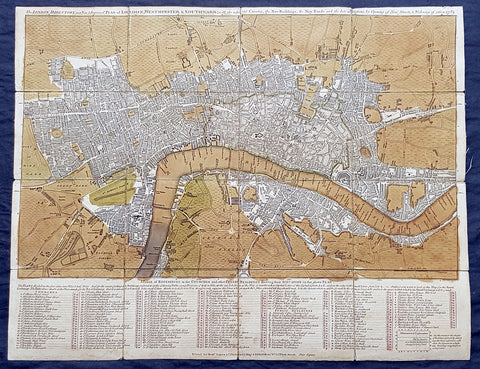
1782 Robert Sayer & John Bennett Large Early Antique Map of London, Rare
- Title : The London Directory or a New & Improved Plan of London, Westminster & Southwark; with the adjacent Country, the New Buildings, the New Roads and the late alterations by Opening of New Streets, & Widening of others 1782.
- Size: 20 1/2in x 16in (510mm x 410mm)
- Condition: (A) Very Good Condition
- Date : 1782
- Ref #: 93047
Description:
This original copper-plate engraved antique segmented map laid on linen of London was engraved in 1782 - dated - and published by Robert Sayer and John Bennett, London.
General Definitions:
Paper thickness and quality: - Heavy and stable
Paper color : - off white
Age of map color: - Original
Colors used: - Green, brown
General color appearance: - Authentic
Paper size: - 20 1/2in x 16in (510mm x 410mm)
Plate size: - 20 1/2in x 16in (510mm x 410mm)
Margins: - Min 1/2in (12mm)
Imperfections:
Margins: - Age toning
Plate area: - Age toned
Verso: - Linen backed
Background:
A highly appealing 1783 map centered on the Thames River. The map details central London from Islington to Shadwell and from Newington Butts to Tyburn. Only three bridges are shown, across the Thames: Westminster Bridge, London Bridge, and Blackfriars (B.L. Fryers). The portions of the city devastated by the 1666 Great Fire of London is marked. A street index and public building index appears below the map proper. The earliest edition of this map was published by Sayer in 1765, with numerous updates to about 1800 – all states are rare, this being the 7th of 1783. Another, almost identical version of this map was issued by John Carrington and, having a slightly longer lifespan, was published and updated until about 1811.
Sayer, Robert 1725 - 1794
Sayer was an important English map publisher and engraver active from the mid to late 18th century. Sayer was born in Sunderland, England, in 1725. He may have clerked as a young man with the Bank of England, but this is unclear. His brother, James Sayer, married Mary Overton, daughter-in-law of John Overton and widow of Philip Overton. Sayer initially worked under Mary Overton, but by December of 1748 was managing the Overton enterprise and gradually took it over, transitioning the plates to his own name. When Thomas Jefferys went bankrupt in 1766, Sayer offered financial assistance to help him stay in business and, in this way, acquired rights to many of the important Jefferys map plates as well as his unpublished research. From about 1774, he began publishing with his apprentice, John Bennett (fl. 1770-1784), as Sayer and Bennett, but the partnership was not formalized until 1777. Bennett retired in 1784 following a mental collapse and the imprint reverted to Robert Sayer. From 1790, Sayer added Robert Laurie and James Whittle to his enterprise, renaming the firm Robert Sayer and Company. Ultimately, Laurie and Whittle partnered to take over his firm. Sayer retired to Bath, where, after a long illness, he died. During most of his career, Sayer was based at 53 Fleet Street, London. His work is particularly significant for its publication of many British maps relating to the American Revolutionary War. Unlike many map makers of his generation, Sayer was a good businessman and left a personal fortune and great estate to his son, James Sayer, who never worked in the publishing business.
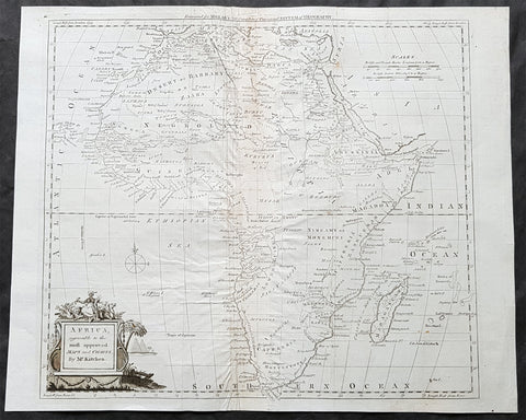
1782 Thomas Kitchin Large Original Antique Map of Africa
- Title : Africa agreeable to the most approved Maps and Charts by Mr Kitchin
- Size: 17in x 14in (435mm x 355mm)
- Condition: (A) Very Good Condition
- Date : 1782
- Ref #: 24047
Description:
This large original antique copper-plate engraved map of Africa by the famous English cartographer Thomas Kitchin was published for the 1782 edition of George Henry Millars New Complete & Universal System of Geography
General Definitions:
Paper thickness and quality: - Heavy and stable
Paper color : - off white
Age of map color: -
Colors used: -
General color appearance: -
Paper size: - 17in x 14in (435mm x 355mm)
Plate size: - 15in x 13 1/2in (380mm x 345mm)
Margins: - Min 1/2in (10mm)
Imperfections:
Margins: - Centerfold re-enforced on verso
Plate area: - Creasing along centerfold
Verso: - Centerfold re-enforced on verso
Background:
Millar, George Henry
Was responsible for the publication of The new and universal system of geography : being a complete history and description of the whole world, containing a particular, full, accurate, circumstantial and entertaining account, including the antient and present state of all the various countries of Europe, Asia, Africa, and America, as divided into empires, kingdoms, states, republics, and colonies.. Printed by Alexander Hogg ..., 1782.
This comprehensive world geography and history was liberally illustrated with decorative plates and maps covering Europe, Asia, Africa, and America with information about the history, geography, climate, people, flora and fauna etc. It also includes important eighteenth century voyages and discoveries including Captain Cook\\\\\\\'s second voyage. Although his third voyage is not included, there is a plate illustrating his death in Hawaii. Other illustrations include city views from around the world, native costumes and occupations, and indigenous flora and fauna. The foldout maps were engraved by Kitchin, Bowen, Conder and Lodge with plates by several renowned English engravers. There is a fine map of the American colonies and city plans for the harbors of New York, Charleston, Havana, and Boston. Complete with upwards of 120 capital engravings with 25 maps. Published by Alexander Hogg, London.

1783 Du Bocage Antique Map of Sparta and Surrounding Area, Greece
- Title : Essai Sur la Topographie De Sparte Et De Ses Environs.... 1783.
- Ref #: 16447
- Size: 15 1/2in x 9 1/2in (400mm x 240mm)
- Date : 1783
- Condition: (A+) Fine Condition
Description:
This fine large original antique map of Sparta and surrounding area, Greece - was engraved in 1783 - dated - and was published by Jean Denis Barbie du Bocage in his Voyage Anacharsis (The Travels of Anacharsis the Younger in Greece)published between 1781 - 1788.
Voyage Anacharsis is an illustrative account of the travels of Anacharsis the Younger in Greece, during the middle of the fourth century before the Christian era.
Jean Denis Barbie du Bocage (1760 - 1825)and his son Jean-Guillaume Barbie du Bocage (1795 - 1848) were French cartographers and cosmographers active in Paris during late 18th and early 19th centuries. The elder Barbie du Bocage, Jean Denis, was trained as a cartographer and engraver in the workshops of mapmaking legend J. B. B. d'Anville. At some point Jean Denis held the post of Royal Librarian of France and it was through is associations with d'Anville that the d'Anville collection of nearly 9000 maps was acquired by French Ministry of Foreign Affairs. The younger Barbie du Bocage, Jean-Guillaume, acquired a position shortly afterwards at the Ministry of Foreign Affairs and, in time, became its head, with the title of Geographe du Ministere des Affaires Etrangeres. (Ref: Tooley; M&B)
General Description:
Paper thickness and quality: - Heavy & stable
Paper color: - White
Age of map color: -
Colors used: -
General color appearance: -
Paper size: - 15 1/2in x 9 1/2in (400mm x 240mm)
Plate size: - 12 1/2in x 8in (310mm x 200mm)
Margins: - Min 1/2in (12mm)
Imperfections:
Margins: - None
Plate area: - Folds as issued
Verso: - None
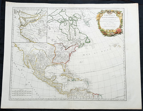
1783 R. De Vaugondy Large Antique 1st Post Revolutionary Map of North America
Antique Map
- Title : Amerique Septentrionale ...Les Etats Unis...1783...Robert De Vaugondy
- Ref #: 93503-1
- Size: 27 1/2in x 21 1/2in (700mm x 540mm)
- Date : 1783
- Condition: (A+) Fine Condition
Description:
This large original beautifully hand coloured copper plate antique map of post revolutionary North America & the newly form United States was engraved in 1783 - dated - and was published by Robert De Vaugondy in his large elephant folio Atlas Universal
This map is in beautiful original condition, original margins, original outline colour on strong sturdy paper with a heavy impression. A must for any collector of maps of historical importance.
General Definitions:
Paper thickness and quality: - Heavy and stable
Paper color : - off white
Age of map color: - Original
Colors used: - Blue, pink, red, green, yellow
General color appearance: - Authentic
Paper size: - 27 1/2in x 21 1/2in (700mm x 540mm)
Plate size: - 25 1/2in x 18 1/2in (650mm x 465mm)
Margins: - Min 1in (25mm)
Imperfections:
Margins: - None
Plate area: - None
Verso: - None
Background:
This is Robert De Vaugondys 5th State of his North America map and one of the first to show the newly liberated American States, after the American Revolutionary War 1775 - 1783.
The maps includes an engraved borderline for the newly founded United States as agreed upon by the Treaty of Paris in 1783. Also, the maps title was altered from earlier states to incorporate the name (in French) for the United States, Etats Unis, which also appears on the map itself. This state includes much other new information along with the place names that were added to the previous state, such as the Newport, New York City, and Bermuda. Florida is shown as an archipelago and the coastline of California is quite curious, with a continuation of the coastline in the inset map of the Northwest showing some of the mythical cartography, such as the Sea of the West and River of the West, which were debated among map scholars and explorers until Captain James Cook dispelled these myths in his three Voyages to the Pacific.
The map also locates the area identified as Fou-sang, reflecting the belief that Chinese mariners may have reached America, the location of the mythical colony of Fou-sang. According to some historians such as Charles Godfrey Leland and Joseph de Guignes ( Le Fou-Sang des Chinois est-il lAmérique Mémoires de lAcadémie des Inscriptions et Belles Lettres, tome 28, Paris, 1761), the distances given by Hui Shen (20,000 Chinese li) would locate Fou-sang on the west coast of the American continent, near British Columbia.
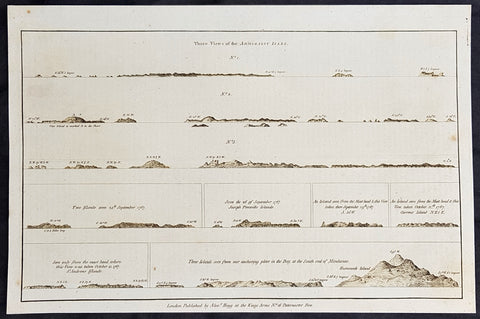
1784 Anderson Antique Coastal Views of the Admiralty Isles of PNG & Mindanao Islands - Capt Cook 1767
- Title : Three Views of the Admiralty Isles; Two islands seen 24th September 1767; Seen the 26 of September 1767, Joseph Freewills Islands; An island seen from the mast head & this view taken there September 29th 1767, S. 50W; An island seen from the mast head & this view taken October 12th 1767. Current Island, N.E. 1/2 E; Seen only from the mast head where this view was taken October 15, 1767. St. Andrews Islands; Three islands seen from our anchoring place in the Bay at the south end of Mindinao.
- Date : 1784
- Ref # : 21696
- Size : 13in x 9in (330mm x 230mm)
- Condition: (A+) Fine Condition
Description:
This fine original copper-plate engraved antique 8 nautical chart & coastal view of the Admiralty Islands, off the coast of north PNG, along with St Andrews & Joseph Freewill Islands sighted by James Cook from September to October 1767 and the last view being a coastal view of southern Mindanao Islands in the Philippines, was published in George Andersons 1784 edition of A Collection of voyages round the world : performed by royal authority : containing a complete historical account of Captain Cooks first, second, third and last voyages, undertaken for making new discoveries, &c. ... published by Alexander Hogg, London 1784.
1.2.3 Three Views of the Admiralty Isles
4. Two islands seen 24th September 1767
5. Seen the 26 of September 1767, Joseph Freewills Islands
6. An island seen from the mast head & this view taken there September 29th 1767, S. 50W.
7. An island seen from the mast head & this view taken October 12th 1767. Current Island, N.E. 1/2 E.
8. Seen only from the mast head where this view was taken October 15, 1767. St. Andrews Islands
9. Three islands seen from our anchoring place in the Bay at the south end of Mindinao.
General Definitions:
Paper thickness and quality: - Heavy and stable
Paper color : - off white
Age of map color: -
Colors used: -
General color appearance: -
Paper size: - 13 1/2in x 9 1/2in (345mm x 240mm)
Plate size: - 13 1/2in x 9 1/2in (345mm x 240mm)
Margins: - Min 1/2in (12mm)
Imperfections:
Margins: - None
Plate area: - None
Verso: - None
Background:
The Admiralty Islands are an archipelago group of 18 islands in the Bismarck Archipelago, to the north of New Guinea in the South Pacific Ocean. These are also sometimes called the Manus Islands, after the largest island.
Mindanao is the second largest island in the Philippines. Mindanao and the smaller islands surrounding it make up the island group of the same name.
Cooks First Voyage (1768–71) In 1766, the Admiralty engaged Cook to command a scientific voyage to the Pacific Ocean. The purpose of the voyage was to observe and record the transit of Venus across the Sun for the benefit of a Royal Society inquiry into a means of determining longitude. Cook, at the age of 39, was promoted to lieutenant to grant him sufficient status to take the command. For its part the Royal Society agreed that Cook would receive a one hundred guinea gratuity in addition to his Naval pay.
The expedition sailed aboard HMS Endeavour, departing England on 26 August 1768. Cook and his crew rounded Cape Horn and continued westward across the Pacific to arrive at Tahiti on 13 April 1769, where the observations of the Venus Transit were made. However, the result of the observations was not as conclusive or accurate as had been hoped. Once the observations were completed, Cook opened the sealed orders which were additional instructions from the Admiralty for the second part of his voyage: to search the south Pacific for signs of the postulated rich southern continent of Terra Australis. Cook then sailed to New Zealand and mapped the complete coastline, making only some minor errors. He then voyaged west, reaching the south-eastern coast of Australia on 19 April 1770, and in doing so his expedition became the first recorded Europeans to have encountered its eastern coastline.
On 23 April he made his first recorded direct observation of indigenous Australians at Brush Island near Bawley Point, noting in his journal: “...and were so near the Shore as to distinguish several people upon the Sea beach they appear\\\'d to be of a very dark or black Colour but whether this was the real colour of their skins or the Clothes they might have on I know not. On 29 April Cook and crew made their first landfall on the mainland of the continent at a place now known as the Kurnell Peninsula. Cook originally christened the area as \\\"Stingray Bay\\\", but later he crossed this out and named it Botany Bay after the unique specimens retrieved by the botanists Joseph Banks and Daniel Solander. It is here that James Cook made first contact with an aboriginal tribe known as the Gweagal.
After his departure from Botany Bay he continued northwards. He stopped at Bustard Bay (now known as Seventeen Seventy or 1770) at 8 o’clock on 23 May 1770. On 24 May Cook and Banks and others went ashore. Continuing north, on 11 June a mishap occurred when HMS Endeavour ran aground on a shoal of the Great Barrier Reef, and then nursed into a river mouth on 18 June 1770. The ship was badly damaged and his voyage was delayed almost seven weeks while repairs were carried out on the beach (near the docks of modern Cooktown, Queensland, at the mouth of the Endeavour River). The voyage then continued, sailing through Torres Strait and on 22 August Cook landed on Possession Island, where he claimed the entire coastline that he had just explored as British territory. He returned to England via Batavia (modern Jakarta, Indonesia), where many in his crew succumbed to malaria, and then the Cape of Good Hope, arriving at the island of Saint Helena on 12 July 1771.
Cook\\\'s journals were published upon his return, and he became something of a hero among the scientific community. Among the general public, however, the aristocratic botanist Joseph Banks was a greater hero. Banks even attempted to take command of Cook\\\'s second voyage, but removed himself from the voyage before it began, and Johann Reinhold Forster and his son Georg Forster were taken on as scientists for the voyage. Cook\\\'s son George was born five days before he left for his second voyage.
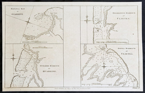
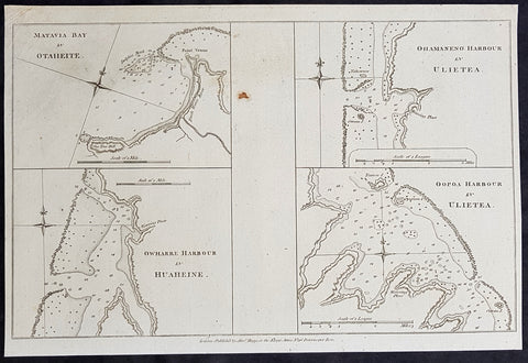
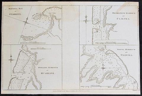
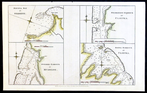
1784 Anderson Antique Map Capt Cook Exploration of the Society Islands in French Polynesia
- Title : Matavia Bay in Otaheite; Ohamaneno Harbour in Ulietea; Owharre Harbourin Huaheine; Oopoa Harbour in Ulietea
- Date : 1784
- Ref # : 16082
- Size : 13 1/2in x 9 1/2in (345mm x 240mm)
- Condition: (A+) Fine Condition
Description:
This fine original copper-plate engraved antique map with surveys and depth soundings of four bays and harbours, of various bays & harbours of the Society Islands, French Polynesia made by explorers during the 17th & 18th centuries.
The first map is Matavia Bay, on the island of Tahiti (Otaheite), the second is Fare (Owharre) Harbour on the island of Huahine & the last two are Ohamaneno & Oopoa (Fa aroa Bay) harbours on the island of Raiatea (Ulietea) was published in George Andersons 1784 edition of A Collection of voyages round the world : performed by royal authority : containing a complete historical account of Captain Cooks first, second, third and last voyages, undertaken for making new discoveries, &c. ... published by Alexander Hogg, London 1784.
General Definitions:
Paper thickness and quality: - Heavy and stable
Paper color : - off white
Age of map color: -
Colors used: -
General color appearance: -
Paper size: - 13 1/2in x 9 1/2in (345mm x 240mm)
Plate size: - 13 1/2in x 9 1/2in (345mm x 240mm)
Margins: - Min 1/2in (12mm)
Imperfections:
Margins: - None
Plate area: - None
Verso: - None
Background:
A description of the four Bays & Harbours and their relevance to Capt Cook and other South Seas explorers are;
1.Matavia Bay in Otaheite (Tahiti) - first European to visit Tahiti Capt. Samuel Wallis anchored in Matavai Bay in 1767 as did Louis-Antoine de Bougainville in 1768 & Capt James Cook landed in Matavai Bay in 1769 and returned in his next two voyages.
2. Owharre (Fare) Harbour in Huaheine (Huahine) Captain Cook arrived in fare Harbour on 16 July 1769, with Tupaia navigating the HMS Endeavour
3. Ohamaneno Harbour (Port) in Ulietea (Raiatea)
4. Oopoa (Fa aroa Bay) Harbour in Ulietea (Raiatea)
Raiatea - The first European to record sighting Raiātea was Pedro Fernandes de Queirós in 1606; it was charted as La Fugitiva. The Polynesian navigator, Tupaia, who sailed with explorer James Cook, was born in Raiātea around 1725.
Cook visited Raiatea in 1769 and again in 1773-1774. Omai (c.1751-1780), another young man from Raiātea, travelled with European explorers to London in 1774 and also served as an interpreter to Captain Cook on his second and third journey.
Tahiti.
1784 Anderson Antique Map Capt Cook Exploration of the Society Islands in French Polynesia
- Title : Matavia Bay in Otaheite; Ohamaneno Harbour in Ulietea; Owharre Harbourin Huaheine; Oopoa Harbour in Ulietea
- Date : 1784
- Ref # : 32153
- Size : 13 1/2in x 9 1/2in (345mm x 240mm)
- Condition: (A+) Fine Condition
Description:
This fine original copper-plate engraved antique map with surveys and depth soundings of four bays and harbours, of various bays & harbours of the Society Islands, French Polynesia made by explorers during the 17th & 18th centuries.
The first map is Matavia Bay, on the island of Tahiti (Otaheite), the second is Fare (Owharre) Harbour on the island of Huahine & the last two are Ohamaneno & Oopoa (Fa aroa Bay) harbours on the island of Raiatea (Ulietea) was published in George Andersons 1784 edition of A Collection of voyages round the world : performed by royal authority : containing a complete historical account of Captain Cooks first, second, third and last voyages, undertaken for making new discoveries, &c. ... published by Alexander Hogg, London 1784.
General Definitions:
Paper thickness and quality: - Heavy and stable
Paper color : - off white
Age of map color: -
Colors used: -
General color appearance: -
Paper size: - 13 1/2in x 9 1/2in (345mm x 240mm)
Plate size: - 13 1/2in x 9 1/2in (345mm x 240mm)
Margins: - Min 1/2in (12mm)
Imperfections:
Margins: - None
Plate area: - None
Verso: - None
Background:
A description of the four Bays & Harbours and their relevance to Capt Cook and other South Seas explorers are;
1.Matavia Bay in Otaheite (Tahiti) - first European to visit Tahiti Capt. Samuel Wallis anchored in Matavai Bay in 1767 as did Louis-Antoine de Bougainville in 1768 & Capt James Cook landed in Matavai Bay in 1769 and returned in his next two voyages.
2. Owharre (Fare) Harbour in Huaheine (Huahine) Captain Cook arrived in fare Harbour on 16 July 1769, with Tupaia navigating the HMS Endeavour
3. Ohamaneno Harbour (Port) in Ulietea (Raiatea)
4. Oopoa (Fa aroa Bay) Harbour in Ulietea (Raiatea)
Raiatea - The first European to record sighting Raiātea was Pedro Fernandes de Queirós in 1606; it was charted as La Fugitiva. The Polynesian navigator, Tupaia, who sailed with explorer James Cook, was born in Raiātea around 1725.
Cook visited Raiatea in 1769 and again in 1773-1774. Omai (c.1751-1780), another young man from Raiātea, travelled with European explorers to London in 1774 and also served as an interpreter to Captain Cook on his second and third journey.
Tahiti.
1784 Anderson Antique Map Capt Cook Exploration of the Society Islands in French Polynesia
- Title : Matavia Bay in Otaheite; Ohamaneno Harbour in Ulietea; Owharre Harbourin Huaheine; Oopoa Harbour in Ulietea
- Date : 1784
- Ref # : 32154
- Size : 13 1/2in x 9 1/2in (345mm x 240mm)
- Condition: (A+) Fine Condition
Description:
This fine original copper-plate engraved antique map with surveys and depth soundings of four bays and harbours, of various bays & harbours of the Society Islands, French Polynesia made by explorers during the 17th & 18th centuries.
The first map is Matavia Bay, on the island of Tahiti (Otaheite), the second is Fare (Owharre) Harbour on the island of Huahine & the last two are Ohamaneno & Oopoa (Fa aroa Bay) harbours on the island of Raiatea (Ulietea) was published in George Andersons 1784 edition of A Collection of voyages round the world : performed by royal authority : containing a complete historical account of Captain Cooks first, second, third and last voyages, undertaken for making new discoveries, &c. ... published by Alexander Hogg, London 1784.
General Definitions:
Paper thickness and quality: - Heavy and stable
Paper color : - off white
Age of map color: -
Colors used: -
General color appearance: -
Paper size: - 13 1/2in x 9 1/2in (345mm x 240mm)
Plate size: - 13 1/2in x 9 1/2in (345mm x 240mm)
Margins: - Min 1/2in (12mm)
Imperfections:
Margins: - None
Plate area: - None
Verso: - None
Background:
A description of the four Bays & Harbours and their relevance to Capt Cook and other South Seas explorers are;
1.Matavia Bay in Otaheite (Tahiti) - first European to visit Tahiti Capt. Samuel Wallis anchored in Matavai Bay in 1767 as did Louis-Antoine de Bougainville in 1768 & Capt James Cook landed in Matavai Bay in 1769 and returned in his next two voyages.
2. Owharre (Fare) Harbour in Huaheine (Huahine) Captain Cook arrived in fare Harbour on 16 July 1769, with Tupaia navigating the HMS Endeavour
3. Ohamaneno Harbour (Port) in Ulietea (Raiatea)
4. Oopoa (Fa aroa Bay) Harbour in Ulietea (Raiatea)
Raiatea - The first European to record sighting Raiātea was Pedro Fernandes de Queirós in 1606; it was charted as La Fugitiva. The Polynesian navigator, Tupaia, who sailed with explorer James Cook, was born in Raiātea around 1725.
Cook visited Raiatea in 1769 and again in 1773-1774. Omai (c.1751-1780), another young man from Raiātea, travelled with European explorers to London in 1774 and also served as an interpreter to Captain Cook on his second and third journey.
Tahiti.
1784 Anderson Antique Map Capt Cook Exploration of the Society Islands in French Polynesia
- Title : Matavia Bay in Otaheite; Ohamaneno Harbour in Ulietea; Owharre Harbourin Huaheine; Oopoa Harbour in Ulietea
- Date : 1784
- Ref # : 32197
- Size : 13 1/2in x 9 1/2in (345mm x 240mm)
- Condition: (A+) Fine Condition
Description:
This fine original copper-plate engraved antique map with surveys and depth soundings of four bays and harbours, of various bays & harbours of the Society Islands, French Polynesia made by explorers during the 17th & 18th centuries.
The first map is Matavia Bay, on the island of Tahiti (Otaheite), the second is Fare (Owharre) Harbour on the island of Huahine & the last two are Ohamaneno & Oopoa (Fa aroa Bay) harbours on the island of Raiatea (Ulietea) was published in George Andersons 1784 edition of A Collection of voyages round the world : performed by royal authority : containing a complete historical account of Captain Cooks first, second, third and last voyages, undertaken for making new discoveries, &c. ... published by Alexander Hogg, London 1784.
General Definitions:
Paper thickness and quality: - Heavy and stable
Paper color : - off white
Age of map color: -
Colors used: -
General color appearance: -
Paper size: - 13 1/2in x 9 1/2in (345mm x 240mm)
Plate size: - 13 1/2in x 9 1/2in (345mm x 240mm)
Margins: - Min 1/2in (12mm)
Imperfections:
Margins: - None
Plate area: - None
Verso: - None
Background:
A description of the four Bays & Harbours and their relevance to Capt Cook and other South Seas explorers are;
1.Matavia Bay in Otaheite (Tahiti) - first European to visit Tahiti Capt. Samuel Wallis anchored in Matavai Bay in 1767 as did Louis-Antoine de Bougainville in 1768 & Capt James Cook landed in Matavai Bay in 1769 and returned in his next two voyages.
2. Owharre (Fare) Harbour in Huaheine (Huahine) Captain Cook arrived in fare Harbour on 16 July 1769, with Tupaia navigating the HMS Endeavour
3. Ohamaneno Harbour (Port) in Ulietea (Raiatea)
4. Oopoa (Fa aroa Bay) Harbour in Ulietea (Raiatea)
Raiatea - The first European to record sighting Raiātea was Pedro Fernandes de Queirós in 1606; it was charted as La Fugitiva. The Polynesian navigator, Tupaia, who sailed with explorer James Cook, was born in Raiātea around 1725.
Cook visited Raiatea in 1769 and again in 1773-1774. Omai (c.1751-1780), another young man from Raiātea, travelled with European explorers to London in 1774 and also served as an interpreter to Captain Cook on his second and third journey.
Tahiti.
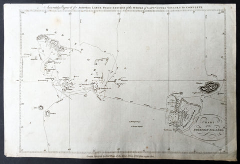
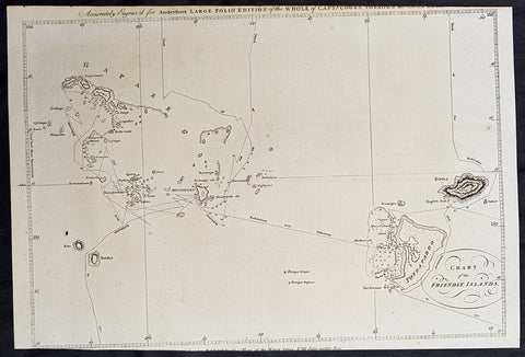
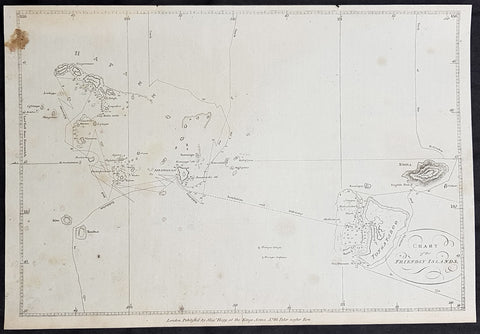
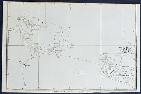
1784 Anderson Antique Map of the Tonga Islands - Capt. Cooks Voyages in 1773 & 1777
- Title : Chart of the Friendly Islands
- Size: 14 1/2in x 9 1/2in (370mm x 245mm)
- Ref #: 32181
- Date : 1784
- Condition: (A) Very Good Condition
This fine original copper-plate engraved antique map of the Tonga Island (Friendly Islands) with the routes taken by Captain James Cook visits to the Islands in his 2nd voyage in 1773 in HMS Resolution & Discovery and his 3rd and last voyage in 1777 in HMS Resolution & Discovery, was published in George Andersons 1784 edition of A Collection of voyages round the world : performed by royal authority : containing a complete historical account of Captain Cooks first, second, third and last voyages, undertaken for making new discoveries, &c. ... published by Alexander Hogg, London 1784.
Exert From Cooks, <i>A Voyage Towards the South Pole, and Round the World, performed in His Majestys Ships the 'Resolution' and 'Adventure', In the Years 1772, 1773, 1774, and 1775.</i>
......<i>after leaving Raiatea (Society Islands) on 18 September 1773, Cook directed his course towards Amsterdam Island (Tongatapu), discovered by Tasman in 1643, intending to verify Tasman's charting against his own charts. The ships stayed for three days, thoroughly enjoying the reception they had received and called the group the Friendly Islands. On his second visit he headed for the Nomuka, the largest island of the south central group of Tonga.</i>
General Definitions:
Paper thickness and quality: - Heavy and stable
Paper color : - off white
Age of map color: -
Colors used: -
General color appearance: -
Paper size: - 14 1/2in x 9 1/2in (370mm x 245mm)
Plate size: - 14 1/2in x 9 1/2in (370mm x 245mm)
Margins: - Min 1/2in (12mm)
Imperfections:
Margins: - None
Plate area: - None
Verso: - None
Background:
Tonga officially the Kingdom of Tonga, is a Polynesian sovereign state and archipelago comprising 169 islands, of which 36 are inhabited. The total surface area is about 750 square kilometres (290 sq mi) scattered over 700,000 square kilometres (270,000 sq mi) of the southern Pacific Ocean. It has a population of 107,122 people, of whom 70% reside on the main island of Tongatapu.
The Tongan people first encountered Europeans in 1616 when the Dutch vessel Eendracht, captained by Willem Schouten, made a short visit to trade. Later came other Dutch explorers, including Jacob Le Maire (who called on the northern island of Niuatoputapu); and in 1643 Abel Tasman (who visited Tongatapu and Haapai).
Later noteworthy European visitors included James Cook (Royal Navy) in 1773, 1774, and 1777; Alessandro Malaspina (Spanish Navy) in 1793; the first London missionaries in 1797; and the Wesleyan Methodist Reverend Walter Lawry in 1822.
Tonga became known in the West as the Friendly Islands because of the congenial reception accorded to Captain James Cook on his first visit in 1773. He arrived at the time of the inasi festival, the yearly donation of the First Fruits to the Tui Tonga (the islands paramount chief) and so received an invitation to the festivities. According to the writer William Mariner, the chiefs wanted to kill Cook during the gathering but could not agree on a plan.
1784 Anderson Antique Map of the Tonga Islands - Capt. Cooks Voyages in 1773 & 1777
- Title : Chart of the Friendly Islands
- Size: 14 1/2in x 9 1/2in (370mm x 245mm)
- Ref #: 21603
- Date : 1784
- Condition: (A) Very Good Condition
This fine original copper-plate engraved antique map of the Tonga Island (Friendly Islands) with the routes taken by Captain James Cook visits to the Islands in his 2nd voyage in 1773 in HMS Resolution & Discovery and his 3rd and last voyage in 1777 in HMS Resolution & Discovery, was published in George Andersons 1784 edition of A Collection of voyages round the world : performed by royal authority : containing a complete historical account of Captain Cooks first, second, third and last voyages, undertaken for making new discoveries, &c. ... published by Alexander Hogg, London 1784.
Exert From Cooks, <i>A Voyage Towards the South Pole, and Round the World, performed in His Majestys Ships the 'Resolution' and 'Adventure', In the Years 1772, 1773, 1774, and 1775.</i>
......<i>after leaving Raiatea (Society Islands) on 18 September 1773, Cook directed his course towards Amsterdam Island (Tongatapu), discovered by Tasman in 1643, intending to verify Tasman's charting against his own charts. The ships stayed for three days, thoroughly enjoying the reception they had received and called the group the Friendly Islands. On his second visit he headed for the Nomuka, the largest island of the south central group of Tonga.</i>
General Definitions:
Paper thickness and quality: - Heavy and stable
Paper color : - off white
Age of map color: -
Colors used: -
General color appearance: -
Paper size: - 14 1/2in x 9 1/2in (370mm x 245mm)
Plate size: - 14 1/2in x 9 1/2in (370mm x 245mm)
Margins: - Min 1/2in (12mm)
Imperfections:
Margins: - Top & bottom margins cropped close to borders
Plate area: - None
Verso: - None
Background:
Tonga officially the Kingdom of Tonga, is a Polynesian sovereign state and archipelago comprising 169 islands, of which 36 are inhabited. The total surface area is about 750 square kilometres (290 sq mi) scattered over 700,000 square kilometres (270,000 sq mi) of the southern Pacific Ocean. It has a population of 107,122 people, of whom 70% reside on the main island of Tongatapu.
The Tongan people first encountered Europeans in 1616 when the Dutch vessel Eendracht, captained by Willem Schouten, made a short visit to trade. Later came other Dutch explorers, including Jacob Le Maire (who called on the northern island of Niuatoputapu); and in 1643 Abel Tasman (who visited Tongatapu and Haapai).
Later noteworthy European visitors included James Cook (Royal Navy) in 1773, 1774, and 1777; Alessandro Malaspina (Spanish Navy) in 1793; the first London missionaries in 1797; and the Wesleyan Methodist Reverend Walter Lawry in 1822.
Tonga became known in the West as the Friendly Islands because of the congenial reception accorded to Captain James Cook on his first visit in 1773. He arrived at the time of the inasi festival, the yearly donation of the First Fruits to the Tui Tonga (the islands paramount chief) and so received an invitation to the festivities. According to the writer William Mariner, the chiefs wanted to kill Cook during the gathering but could not agree on a plan.
1784 Anderson Antique Map of the Tonga Islands - Capt. Cooks Voyages in 1773 & 1777
- Title : Chart of the Friendly Islands
- Size: 13 1/2in x 9 1/2in (360mm x 245mm)
- Ref #: 32152
- Date : 1784
- Condition: (A) Very Good Condition
This fine original copper-plate engraved antique map of the Tonga Island (Friendly Islands) with the routes taken by Captain James Cook visits to the Islands in his 2nd voyage in 1773 in HMS Resolution & Discovery and his 3rd and last voyage in 1777 in HMS Resolution & Discovery, was published in George Andersons 1784 edition of A Collection of voyages round the world : performed by royal authority : containing a complete historical account of Captain Cooks first, second, third and last voyages, undertaken for making new discoveries, &c. ... published by Alexander Hogg, London 1784.
Exert From Cooks, <i>A Voyage Towards the South Pole, and Round the World, performed in His Majestys Ships the 'Resolution' and 'Adventure', In the Years 1772, 1773, 1774, and 1775.</i>
......<i>after leaving Raiatea (Society Islands) on 18 September 1773, Cook directed his course towards Amsterdam Island (Tongatapu), discovered by Tasman in 1643, intending to verify Tasman's charting against his own charts. The ships stayed for three days, thoroughly enjoying the reception they had received and called the group the Friendly Islands. On his second visit he headed for the Nomuka, the largest island of the south central group of Tonga.</i>
General Definitions:
Paper thickness and quality: - Heavy and stable
Paper color : - off white
Age of map color: -
Colors used: -
General color appearance: -
Paper size: - 13 1/2in x 9 1/2in (360mm x 245mm)
Plate size: - 13 1/2in x 9 1/2in (360mm x 245mm)
Margins: - Min 1/2in (12mm)
Imperfections:
Margins: - Brown stain top left
Plate area: - None
Verso: - None
Background:
Tonga officially the Kingdom of Tonga, is a Polynesian sovereign state and archipelago comprising 169 islands, of which 36 are inhabited. The total surface area is about 750 square kilometres (290 sq mi) scattered over 700,000 square kilometres (270,000 sq mi) of the southern Pacific Ocean. It has a population of 107,122 people, of whom 70% reside on the main island of Tongatapu.
The Tongan people first encountered Europeans in 1616 when the Dutch vessel Eendracht, captained by Willem Schouten, made a short visit to trade. Later came other Dutch explorers, including Jacob Le Maire (who called on the northern island of Niuatoputapu); and in 1643 Abel Tasman (who visited Tongatapu and Haapai).
Later noteworthy European visitors included James Cook (Royal Navy) in 1773, 1774, and 1777; Alessandro Malaspina (Spanish Navy) in 1793; the first London missionaries in 1797; and the Wesleyan Methodist Reverend Walter Lawry in 1822.
Tonga became known in the West as the Friendly Islands because of the congenial reception accorded to Captain James Cook on his first visit in 1773. He arrived at the time of the inasi festival, the yearly donation of the First Fruits to the Tui Tonga (the islands paramount chief) and so received an invitation to the festivities. According to the writer William Mariner, the chiefs wanted to kill Cook during the gathering but could not agree on a plan.
1784 Anderson Antique Map of the Tonga Islands - Capt. Cooks Voyages in 1773 & 1777
- Title : Chart of the Friendly Islands
- Size: 13 1/2in x 9 1/2in (360mm x 245mm)
- Ref #: 21443
- Date : 1784
- Condition: (A) Very Good Condition
This fine original copper-plate engraved antique map of the Tonga Island (Friendly Islands) with the routes taken by Captain James Cook visits to the Islands in his 2nd voyage in 1773 in HMS Resolution & Discovery and his 3rd and last voyage in 1777 in HMS Resolution & Discovery, was published in George Andersons 1784 edition of A Collection of voyages round the world : performed by royal authority : containing a complete historical account of Captain Cooks first, second, third and last voyages, undertaken for making new discoveries, &c. ... published by Alexander Hogg, London 1784.
Exert From Cooks, <i>A Voyage Towards the South Pole, and Round the World, performed in His Majestys Ships the 'Resolution' and 'Adventure', In the Years 1772, 1773, 1774, and 1775.</i>
......<i>after leaving Raiatea (Society Islands) on 18 September 1773, Cook directed his course towards Amsterdam Island (Tongatapu), discovered by Tasman in 1643, intending to verify Tasman's charting against his own charts. The ships stayed for three days, thoroughly enjoying the reception they had received and called the group the Friendly Islands. On his second visit he headed for the Nomuka, the largest island of the south central group of Tonga.</i>
General Definitions:
Paper thickness and quality: - Heavy and stable
Paper color : - off white
Age of map color: -
Colors used: -
General color appearance: -
Paper size: - 13 1/2in x 9 1/2in (360mm x 245mm)
Plate size: - 13 1/2in x 9 1/2in (360mm x 245mm)
Margins: - Min 1/2in (12mm)
Imperfections:
Margins: - Top margin cropped to border
Plate area: - None
Verso: - None
Background:
Tonga officially the Kingdom of Tonga, is a Polynesian sovereign state and archipelago comprising 169 islands, of which 36 are inhabited. The total surface area is about 750 square kilometres (290 sq mi) scattered over 700,000 square kilometres (270,000 sq mi) of the southern Pacific Ocean. It has a population of 107,122 people, of whom 70% reside on the main island of Tongatapu.
The Tongan people first encountered Europeans in 1616 when the Dutch vessel Eendracht, captained by Willem Schouten, made a short visit to trade. Later came other Dutch explorers, including Jacob Le Maire (who called on the northern island of Niuatoputapu); and in 1643 Abel Tasman (who visited Tongatapu and Haapai).
Later noteworthy European visitors included James Cook (Royal Navy) in 1773, 1774, and 1777; Alessandro Malaspina (Spanish Navy) in 1793; the first London missionaries in 1797; and the Wesleyan Methodist Reverend Walter Lawry in 1822.
Tonga became known in the West as the Friendly Islands because of the congenial reception accorded to Captain James Cook on his first visit in 1773. He arrived at the time of the inasi festival, the yearly donation of the First Fruits to the Tui Tonga (the islands paramount chief) and so received an invitation to the festivities. According to the writer William Mariner, the chiefs wanted to kill Cook during the gathering but could not agree on a plan.
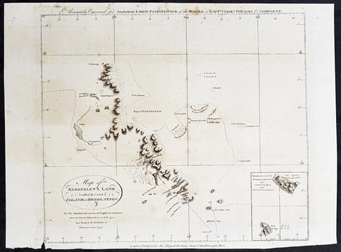
1784 Anderson Antique Map SW Regions of Kerguelen Islands in South Indian Ocean
- Title : Map of Kerguelens Land Called by C Cook Island of Desolation
- Size: 13in x 9 1/2in (330mm x 245mm)
- Ref #: 21694
- Date : 1784
- Condition: (A) Very Good Condition
Description:
This fine original copper-plate engraved antique map of the the Kerguelen Islands in the very Southern Indian Ocean explored by Capt Cooks during his 3rd Voyage of Discovery to the South Seas in December 1776 was published in George Andersons 1784 edition of A Collection of voyages round the world : performed by royal authority : containing a complete historical account of Captain Cook\\\'s first, second, third and last voyages, undertaken for making new discoveries, &c. ...published by Alexander Hogg, London 1784.
General Definitions:
Paper thickness and quality: - Heavy and stable
Paper color : - off white
Age of map color: -
Colors used: -
General color appearance: -
Paper size: - 13in x 9 1/2in (330mm x 245mm)
Plate size: - 13in x 9 1/2in (330mm x 245mm)
Margins: - Min 1/2in (12mm)
Imperfections:
Margins: - Small tear to bottom margin
Plate area: - None
Verso: - Light spotting
Background:
The Kerguelen Islands also known as the Desolation Islands are a group of islands in the southern Indian Ocean constituting one of the two exposed parts of the mostly submerged Kerguelen Plateau. They are among the most isolated places on Earth, located 450 km (280 mi) northwest of the uninhabited Heard Island and McDonald Islands and more than 3,300 km (2,051 mi) from Madagascar, the nearest populated location (excluding the Alfred Faure scientific station in Île de la Possession, about 1,340 km (830 mi) from there, and the non-permanent station located in Île Amsterdam, 1,440 km (890 mi) away). The islands, along with Adélie Land, the Crozet Islands, Amsterdam, and Saint Paul Islands, and France\'s Scattered Islands in the Indian Ocean are part of the French Southern and Antarctic Lands and are administered as a separate district.
The main island, Grande Terre, is 6,675 km2 in area and is surrounded by a further 300 smaller islands and islets, forming an archipelago of 7,215 km2. The climate is raw and chilly with frequent high winds throughout the year. The surrounding seas are generally rough and they remain ice-free year-round. There are no indigenous inhabitants, but France maintains a permanent presence of 45 to 100 scientists, engineers and researchers. There are no airports on the islands, so all travel and transport from the outside world is conducted by ship.
Kerguelen Islands appear as the Ile de Nachtegal on Philippe Buache\'s map from 1754 before the island was officially discovered in 1772. The Buache map has the title Carte des Terres Australes comprises entre le Tropique du Capricorne et le Pôle Antarctique où se voyent les nouvelles découvertes faites en 1739 au Sud du Cap de Bonne Esperance (Map of the Southern Lands contained between the Tropic of Capricorn and the Antarctic Pole, where the new discoveries made in 1739 to the south of the Cape of Good Hope may be seen). It is possible this early name was after Abel Tasman\'s ship De Zeeuwsche Nachtegaal. On the Buache map, Ile de Nachtega\" is located at 43°S, 72°E, about 6 degrees north and 2 degrees east of the accepted location of Grande Terre.
The islands were officially discovered by the French navigator Yves-Joseph de Kerguelen-Trémarec on 12 February 1772. The next day Charles de Boisguehenneuc landed and claimed the island for the French crown. Yves de Kerguelen organised a second expedition in 1773 and arrived at the \"baie de l\'Oiseau\" by December of the same year. On 6 January 1774 he commanded his lieutenant, Henri Pascal de Rochegude, to leave a message notifying any passers-by of the two passages and of the French claim to the islands. Thereafter, a number of expeditions briefly visited the islands, including that of Captain James Cook in December 1776 during his third voyage, who verified and confirmed the passage of de Kerguelen by discovering and annotating the message left by the French navigator.
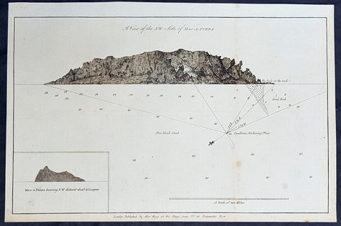
1784 Anderson Antique Print of Alejandro Selkirk Isle (Mas Afuera), Chile - Capt Carteret in 1767
- Title : A View of the NW Side of Mas-A-Fuera: Mas-a-Fuera bearing NW Distant about 23 Leagues
- Size: 13 1/2in x 9 1/2in (360mm x 245mm)
- Ref #: 21599
- Date : 1784
- Condition: (A+) Fine Condition
Description:
This fine original copper-plate engraved antique print two relief views of the NW side of the Pacific Island of Alejandro Selkirk, previously known as Mas Afuera Island, in the Juan Ferandez Archipelago of the Valparaiso Region of Chile, was mapped with depths taken whilst anchored, by Captain Philip Carteret in his ship the Swallow in 1767 and was published in George Andersons 1784 edition of A Collection of voyages round the world : performed by royal authority : containing a complete historical account of Captain Cooks first, second, third and last voyages, undertaken for making new discoveries, &c. ... published by Alexander Hogg, London 1784.
General Definitions:
Paper thickness and quality: - Heavy and stable
Paper color : - off white
Age of map color: -
Colors used: -
General color appearance: -
Paper size: - 13 1/2in x 9 1/2in (345mm x 240mm)
Plate size: - 13 1/2in x 9 1/2in (345mm x 240mm)
Margins: - Min 1/2in (12mm)
Imperfections:
Margins: - None
Plate area: - None
Verso: - None
Background:
Philip Carteret (1733-1796)
was a British naval officer and explorer who participated in two of the Royal Navy\'s circumnavigation expeditions in 1764-66 and 1766-69.
Carteret entered the Navy in 1747, serving aboard the Salisbury, and then under Captain John Byron from 1751 to 1755. Between 1757 and 1758 he was in the Guernsey on the Mediterranean Station. As a lieutenant in the Dolphin he accompanied Byron during his voyage of circumnavigation, from June 1764 to May 1766.
In 1766 he was made a commander and given the command of the Swallow to circumnavigate the world, as consort to the Dolphin under the command of Samuel WalCaptain James Cooklis. The two ships were parted shortly after sailing through the Strait of Magellan, Carteret discovering Pitcairn Island and the Carteret Islands, which were subsequently named after him. In 1767, he also discovered a new archipelago inside Saint George\'s Channel between New Ireland and New Britain Islands (Papua New Guinea) and named it Duke of York Islands, as well as rediscovered the Solomon Islands first sighted by the Mendana in 1568, and the Juan Fernandez Islands first discovered by Juan Fernandez in 1574. He arrived back in England, at Spithead, on 20 March 1769.
He was promoted to post captain in 1771.
Alejandro Selkirk Island previously known as Mas Afuera (Farther Out (to Sea)) and renamed after the marooned sailor Alexander Selkirk, is the largest and most westerly island in the Juan Ferandez Archipelago of the Valparaíso Region of Chile. It is situated 180 km (100 nmi; 110 mi) west of Robinson Crusoe Island in the southeastern Pacific Ocean.
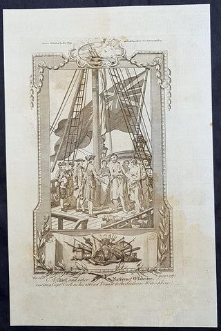
1784 Anderson Antique Print of King Pomare I of Tahiti w/ Captain Cook on the Resolution 1773
- Title : A Chief and other Natives of O Taheitee visiting Captain Cook in his second Voyage to the Southern Hemisphere
- Date : 1784
- Ref # : 21507
- Size : 13 1/2in x 9 1/2in (345mm x 240mm)
- Condition: (A) Very Good Condition
Description:
This fine original copper-plate engraved antique print of Captain James Cook meeting Pomare I & other Tahitian dignitaries on HMS Resolution, during his second Voyage of Discovery to the South Seas in 1773 & 1774, was published in George Andersons 1784 edition of A Collection of voyages round the world : performed by royal authority : containing a complete historical account of Captain Cooks first, second, third and last voyages, undertaken for making new discoveries, &c. ... published by Alexander Hogg, London 1784.
Among the Tahitian dignitaries were chiefs whom Cook had met during his 1st voyage and others that had come to power during his absence.
Cook was warmly greeted by the chiefs Tai and Puhi, besides the youg ari i Vehiatua II and his stepfather Ti itorea. Cook anchored in Vaitepiha Bay before returning to Point Venus where he met Tu (Pomare I) the paramount chief.
Cook picked up two passengers from Tahiti during this trip, Porea and Mai, with Hitihiti later replacing Porea when Cook stopped at Raiatea. Cook took Hitihiti to Tahiti on 22 April, during his return leg. Cook departed Tahiti on 14 May 1774.
Pomare I 1753 – 1803 (fully in old orthography: Tu-nui-ea-i-te-atua-i-Tarahoi Vaira atoa Taina Pomare I; also known as Tu or Tinah or Outu, or more formally as Tu-nui-a a-i-te-atua), was the unifier and first king of Tahiti and founder of the Pomare dynasty and the Kingdom of Tahiti between 1788 and 1791. He abdicated in 1791, but remained in power as the guardian regent during the minority of his successor Pomare II from 1791 until 1803.
Pomare I was born at Pare, and was the second son of Teu Tunuieaiteatua by his wife, Tetupaia-i-Hauiri. He initially reigned under the regency of his father. He succeeded on the death of his father as Ari i-rahi of Porionu u 23 November 1802.
Pomare was the Tahitian chieftain most friendly to the British. The additional British captains arriving at Tahiti accepted his claim to hegemony. They gave him guns in trade and helped him in his battles. Captain Cook gave him the advantage in a number of battles with rival forces during his last stay in Tahiti. British missionaries arrived, sent by a non-denominational Protestant group called the London Missionary Society. Pomare befriended the missionaries, and the missionaries favored both peace and Pomare, but, with the British unwilling to apply force to create order among the islands, the missionaries were unable to stop the warring.
General Definitions:
Paper thickness and quality: - Heavy and stable
Paper color : - off white
Age of map color: -
Colors used: -
General color appearance: -
Paper size: - 13 1/2in x 9 1/2in (345mm x 240mm)
Plate size: - 13 1/2in x 9 1/2in (345mm x 240mm)
Margins: - Min 1/2in (12mm)
Imperfections:
Margins: - Age toning
Plate area: - Age toning
Verso: - Age toning
Background:
Cooks Second Voyage (1772–75) Shortly after his return from the first voyage, Cook was promoted in August 1771, to the rank of commander. In 1772 he was commissioned to lead another scientific expedition on behalf of the Royal Society, to search for the hypothetical Terra Australis. On his first voyage, Cook had demonstrated by circumnavigating New Zealand that it was not attached to a larger landmass to the south. Although he charted almost the entire eastern coastline of Australia, showing it to be continental in size, the Terra Australis was believed to lie further south. Despite this evidence to the contrary, Alexander Dalrymple and others of the Royal Society still believed that a massive southern continent should exist.
Cook commanded HMS Resolution on this voyage, while Tobias Furneaux commanded its companion ship, HMS Adventure. Cook\\\'s expedition circumnavigated the globe at an extreme southern latitude, becoming one of the first to cross the Antarctic Circle (17 January 1773). In the Antarctic fog, Resolution and Adventure became separated. Furneaux made his way to New Zealand, where he lost some of his men during an encounter with Māori, and eventually sailed back to Britain, while Cook continued to explore the Antarctic, reaching 71°10\\\'S on 31 January 1774.
Cook almost encountered the mainland of Antarctica, but turned towards Tahiti to resupply his ship. He then resumed his southward course in a second fruitless attempt to find the supposed continent. On this leg of the voyage he brought a young Tahitian named Omai, who proved to be somewhat less knowledgeable about the Pacific than Tupaia had been on the first voyage. On his return voyage to New Zealand in 1774, Cook landed at the Friendly Islands, Easter Island, Norfolk Island, New Caledonia, and Vanuatu.
Before returning to England, Cook made a final sweep across the South Atlantic from Cape Horn and surveyed, mapped and took possession for Britain of South Georgia, which had been explored by Anthony de la Roché in 1675. Cook also discovered and named Clerke Rocks and the South Sandwich Islands (\\\"Sandwich Land\\\"). He then turned north to South Africa, and from there continued back to England. His reports upon his return home put to rest the popular myth of Terra Australis.
Cook\\\'s second voyage marked a successful employment of Larcum Kendall\\\'s K1 copy of John Harrison\\\'s H4 marine chronometer, which enabled Cook to calculate his longitudinal position with much greater accuracy. Cook\\\'s log was full of praise for this time-piece which he used to make charts of the southern Pacific Ocean that were so remarkably accurate that copies of them were still in use in the mid-20th century.
Upon his return, Cook was promoted to the rank of post-captain and given an honorary retirement from the Royal Navy, with a posting as an officer of the Greenwich Hospital. He reluctantly accepted, insisting that he be allowed to quit the post if an opportunity for active duty should arise. His fame extended beyond the Admiralty; he was made a Fellow of the Royal Society, and awarded the Copley Gold Medal for completing his second voyage without losing a man to scurvy. Nathaniel Dance-Holland painted his portrait; he dined with James Boswell; he was described in the House of Lords as \\\"the first navigator in Europe\\\". But he could not be kept away from the sea. A third voyage was planned and Cook volunteered to find the Northwest Passage. He travelled to the Pacific and hoped to travel east to the Atlantic, while a simultaneous voyage travelled the opposite route.
Tahiti previously also known as Otaheite is the largest island in the Windward group of French Polynesia. The island is located in the archipelago of the Society Islands in the central Southern Pacific Ocean.
The first European to have visited Tahiti according to existing records was lieutenant Samuel Wallis, who was circumnavigating the globe in HMS Dolphin, sighting the island on 18 June 1767, and eventually harboring in Matavai Bay. This bay was situated on the territory of the chiefdom of Pare-Arue, governed by Tu (Tu-nui-e-a\\\\\\\'a-i-te-Atua) and his regent Tutaha, and the chiefdom of Ha apape, governed by Amo and his wife Oberea (Purea). Wallis named the island King Georges Island. The first contacts were difficult, since on the 24 and 26 June 1767, Tahitian warriors in canoes showed aggression towards the British, hurling stones from their slings. In retaliation, the British sailors opened fire on the warriors in the canoes and on the hills. In reaction to this powerful counter-attack, the Tahitians laid down peace offerings for the British. Following this episode, Samuel Wallis was able to establish cordial relations with the female chieftain “Oberea “ (Purea) and remained on the island until 27 July 1767.
In July 1768, Captain James Cook was commissioned by the Royal Society and on orders from the Lords Commissioners of the Admiralty to observe the transit of Venus across the sun, a phenomenon that would be visible from Tahiti on 3 June 1769. He arrived in Tahitis Matavai Bay, commanding the HMS Endeavour on 12 April 1769. On 14 April, Cook met with Tutaha and Tepau. On 15 April, Cook picked the site for a fortified camp at Point Venus along with Banks, Parkinson, Daniel Solander, to protect Charles Greens observatory. The length of stay enabled them to undertake for the first time real ethnographic and scientific observations of the island. Assisted by the botanist Joseph Banks, and by the artist Sydney Parkinson, Cook gathered valuable information on the fauna and flora, as well as the native society, language and customs, including the proper name of the island, Otaheite. On 28 April, Cook met Purea and Tupaia, and Tupaia befriended Banks following the transit. On 21 June, Amo visited Cook, and then on 25 June, Pohuetea visited, signifying another chief seeking to ally himself with the British.
Cook and Banks circumnavigated the island from 26 June to 1 July. On the exploration, they met Ahio, chief of Ha apaiano o or Papenoo, Rita, chief of Hitia a, Pahairro, chief of Pueu, Vehiatua, chief of Tautra, Matahiapo, chief of Teahupo o, Tutea, chief of Vaira o, and Moe, chief of Afa\\\\\\\'Ahiti. In Papara, guided by Tupaia, they investigated the ruins of Mahaiatea marae, an impressive structure containing a stone pyramid or ahu, measuring 44 feet high, 267 feet long and 87 feet wide. Cook and the Endeavour departed Tahiti on 13 July 1769, taking Raiatean navigator Tupaia along for his geographic knowledge of the islands.
Cook returned to Tahiti between 15 August and 1 September 1773, greeted by the chiefs Tai and Puhi, besides the youg ari i Vehiatua II and his stepfather Ti itorea. Cook anchored in Vaitepiha Bay before returning to Point Venus where he met Tu, the paramount chief. Cook picked up two passengers from Tahiti during this trip, Porea and Ma\\\\\\\'i, with Hitihiti later replacing Porea when Cook stopped at Raiatea. Cook took Hitihiti to Tahiti on 22 April, during his return leg. Then, Cook departed Tahiti on 14 May 1774.
During his final visit, Cook returned Mai to Tahiti on 12 Aug. 1777, after Mais long visit in England. Cook also brought two Maori from Queen Charlotte Sound, Te Weherua and Koa. Cook first harbored in Vaitepiha Bay, where he visited Vehiatua II s funeral bier and the prefabricated Spanish mission house. Cook also met Vehiatua III, and inscribed on the back of the Spanish cross, Georgius tertius Rex Annis 1767, 69, 73, 74 & 77, as a counterpoint to Christus Vincit Carolus III imperat 1774 on the front. On 23 Aug., Cook sailed for Matavai Bay, where he met Tu, his father Teu, his mother Tetupaia, his brothers Ari ipaea and Vaetua, and his sisters Ari ipaea-vahine, Tetua-te-ahamai, and Auo. Cook also observed a human sacrifice, taata tapu, at the Utu-ai-mahurau marae, and 49 skulls from previous victims.
On 29 Sept. 1777, Cook sailed for Papetoai Bay on Moorea. Cook met Mahine in an act of friendship on 3 Oct., though he was an enemy of Tu. When a goat kid was stolen on 6 Oct., Cook in a rampage, ordered the burning of houses and canoes until it was returned. Cook sailed for Huahine on 11 Oct., Raiatea on 2 Nov., and Borabora on 7 Dec.
On 26 October 1788, HMS Bounty, under the command of Captain William Bligh, landed in Tahiti with the mission of carrying Tahitian breadfruit trees (Tahitian: uru) to the Caribbean. Sir Joseph Banks, the botanist from James Cooks first expedition, had concluded that this plant would be ideal to feed the African slaves working in the Caribbean plantations at very little cost. The crew remained in Tahiti for about five months, the time needed to transplant the seedlings of the trees. Three weeks after leaving Tahiti, on 28 April 1789, the crew mutinied on the initiative of Fletcher Christian. The mutineers seized the ship and set the captain and most of those members of the crew who remained loyal to him adrift in a ship\\\\\\\'s boat. A group of mutineers then went back to settle in Tahiti.
Although various explorers had refused to get involved in tribal conflicts, the mutineers from the Bounty offered their services as mercenaries and furnished arms to the family which became the Pōmare Dynasty. The chief Tū knew how to use their presence in the harbours favoured by sailors to his advantage. As a result of his alliance with the mutineers, he succeeded in considerably increasing his supremacy over the island of Tahiti.
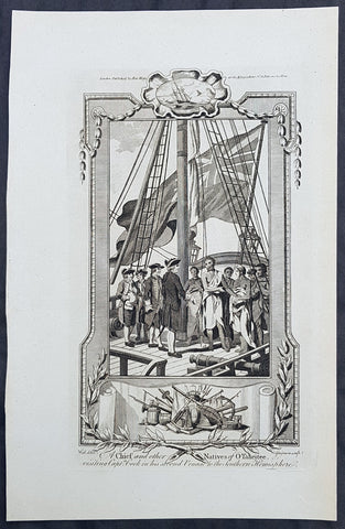
1784 Anderson Antique Print of King Pomare I of Tahiti w/ Captain Cook on the Resolution 1773
- Title : A Chief and other Natives of O Taheitee visiting Captain Cook in his second Voyage to the Southern Hemisphere
- Date : 1784
- Ref # : 21618
- Size : 13 1/2in x 9 1/2in (345mm x 240mm)
- Condition: (A+) Fine Condition
Description:
This fine original copper-plate engraved antique print of Captain James Cook meeting Pomare I & other Tahitian dignitaries on HMS Resolution, during his second Voyage of Discovery to the South Seas in 1773 & 1774, was published in George Andersons 1784 edition of A Collection of voyages round the world : performed by royal authority : containing a complete historical account of Captain Cooks first, second, third and last voyages, undertaken for making new discoveries, &c. ... published by Alexander Hogg, London 1784.
Among the Tahitian dignitaries were chiefs whom Cook had met during his 1st voyage and others that had come to power during his absence.
Cook was warmly greeted by the chiefs Tai and Puhi, besides the youg ari i Vehiatua II and his stepfather Ti itorea. Cook anchored in Vaitepiha Bay before returning to Point Venus where he met Tu (Pomare I) the paramount chief.
Cook picked up two passengers from Tahiti during this trip, Porea and Mai, with Hitihiti later replacing Porea when Cook stopped at Raiatea. Cook took Hitihiti to Tahiti on 22 April, during his return leg. Cook departed Tahiti on 14 May 1774.
Pomare I 1753 – 1803 (fully in old orthography: Tu-nui-ea-i-te-atua-i-Tarahoi Vaira atoa Taina Pomare I; also known as Tu or Tinah or Outu, or more formally as Tu-nui-a a-i-te-atua), was the unifier and first king of Tahiti and founder of the Pomare dynasty and the Kingdom of Tahiti between 1788 and 1791. He abdicated in 1791, but remained in power as the guardian regent during the minority of his successor Pomare II from 1791 until 1803.
Pomare I was born at Pare, and was the second son of Teu Tunuieaiteatua by his wife, Tetupaia-i-Hauiri. He initially reigned under the regency of his father. He succeeded on the death of his father as Ari i-rahi of Porionu u 23 November 1802.
Pomare was the Tahitian chieftain most friendly to the British. The additional British captains arriving at Tahiti accepted his claim to hegemony. They gave him guns in trade and helped him in his battles. Captain Cook gave him the advantage in a number of battles with rival forces during his last stay in Tahiti. British missionaries arrived, sent by a non-denominational Protestant group called the London Missionary Society. Pomare befriended the missionaries, and the missionaries favored both peace and Pomare, but, with the British unwilling to apply force to create order among the islands, the missionaries were unable to stop the warring.
General Definitions:
Paper thickness and quality: - Heavy and stable
Paper color : - off white
Age of map color: -
Colors used: -
General color appearance: -
Paper size: - 13 1/2in x 9 1/2in (345mm x 240mm)
Plate size: - 13 1/2in x 9 1/2in (345mm x 240mm)
Margins: - Min 1/2in (12mm)
Imperfections:
Margins: - Age toning
Plate area: - Age toning
Verso: - Age toning
Background:
Cooks Second Voyage (1772–75) Shortly after his return from the first voyage, Cook was promoted in August 1771, to the rank of commander. In 1772 he was commissioned to lead another scientific expedition on behalf of the Royal Society, to search for the hypothetical Terra Australis. On his first voyage, Cook had demonstrated by circumnavigating New Zealand that it was not attached to a larger landmass to the south. Although he charted almost the entire eastern coastline of Australia, showing it to be continental in size, the Terra Australis was believed to lie further south. Despite this evidence to the contrary, Alexander Dalrymple and others of the Royal Society still believed that a massive southern continent should exist.
Cook commanded HMS Resolution on this voyage, while Tobias Furneaux commanded its companion ship, HMS Adventure. Cook\\\'s expedition circumnavigated the globe at an extreme southern latitude, becoming one of the first to cross the Antarctic Circle (17 January 1773). In the Antarctic fog, Resolution and Adventure became separated. Furneaux made his way to New Zealand, where he lost some of his men during an encounter with Māori, and eventually sailed back to Britain, while Cook continued to explore the Antarctic, reaching 71°10\\\'S on 31 January 1774.
Cook almost encountered the mainland of Antarctica, but turned towards Tahiti to resupply his ship. He then resumed his southward course in a second fruitless attempt to find the supposed continent. On this leg of the voyage he brought a young Tahitian named Omai, who proved to be somewhat less knowledgeable about the Pacific than Tupaia had been on the first voyage. On his return voyage to New Zealand in 1774, Cook landed at the Friendly Islands, Easter Island, Norfolk Island, New Caledonia, and Vanuatu.
Before returning to England, Cook made a final sweep across the South Atlantic from Cape Horn and surveyed, mapped and took possession for Britain of South Georgia, which had been explored by Anthony de la Roché in 1675. Cook also discovered and named Clerke Rocks and the South Sandwich Islands (\\\"Sandwich Land\\\"). He then turned north to South Africa, and from there continued back to England. His reports upon his return home put to rest the popular myth of Terra Australis.
Cook\\\'s second voyage marked a successful employment of Larcum Kendall\\\'s K1 copy of John Harrison\\\'s H4 marine chronometer, which enabled Cook to calculate his longitudinal position with much greater accuracy. Cook\\\'s log was full of praise for this time-piece which he used to make charts of the southern Pacific Ocean that were so remarkably accurate that copies of them were still in use in the mid-20th century.
Upon his return, Cook was promoted to the rank of post-captain and given an honorary retirement from the Royal Navy, with a posting as an officer of the Greenwich Hospital. He reluctantly accepted, insisting that he be allowed to quit the post if an opportunity for active duty should arise. His fame extended beyond the Admiralty; he was made a Fellow of the Royal Society, and awarded the Copley Gold Medal for completing his second voyage without losing a man to scurvy. Nathaniel Dance-Holland painted his portrait; he dined with James Boswell; he was described in the House of Lords as \\\"the first navigator in Europe\\\". But he could not be kept away from the sea. A third voyage was planned and Cook volunteered to find the Northwest Passage. He travelled to the Pacific and hoped to travel east to the Atlantic, while a simultaneous voyage travelled the opposite route.
Tahiti previously also known as Otaheite is the largest island in the Windward group of French Polynesia. The island is located in the archipelago of the Society Islands in the central Southern Pacific Ocean.
The first European to have visited Tahiti according to existing records was lieutenant Samuel Wallis, who was circumnavigating the globe in HMS Dolphin, sighting the island on 18 June 1767, and eventually harboring in Matavai Bay. This bay was situated on the territory of the chiefdom of Pare-Arue, governed by Tu (Tu-nui-e-a\\\\\\\'a-i-te-Atua) and his regent Tutaha, and the chiefdom of Ha apape, governed by Amo and his wife Oberea (Purea). Wallis named the island King Georges Island. The first contacts were difficult, since on the 24 and 26 June 1767, Tahitian warriors in canoes showed aggression towards the British, hurling stones from their slings. In retaliation, the British sailors opened fire on the warriors in the canoes and on the hills. In reaction to this powerful counter-attack, the Tahitians laid down peace offerings for the British. Following this episode, Samuel Wallis was able to establish cordial relations with the female chieftain “Oberea “ (Purea) and remained on the island until 27 July 1767.
In July 1768, Captain James Cook was commissioned by the Royal Society and on orders from the Lords Commissioners of the Admiralty to observe the transit of Venus across the sun, a phenomenon that would be visible from Tahiti on 3 June 1769. He arrived in Tahitis Matavai Bay, commanding the HMS Endeavour on 12 April 1769. On 14 April, Cook met with Tutaha and Tepau. On 15 April, Cook picked the site for a fortified camp at Point Venus along with Banks, Parkinson, Daniel Solander, to protect Charles Greens observatory. The length of stay enabled them to undertake for the first time real ethnographic and scientific observations of the island. Assisted by the botanist Joseph Banks, and by the artist Sydney Parkinson, Cook gathered valuable information on the fauna and flora, as well as the native society, language and customs, including the proper name of the island, Otaheite. On 28 April, Cook met Purea and Tupaia, and Tupaia befriended Banks following the transit. On 21 June, Amo visited Cook, and then on 25 June, Pohuetea visited, signifying another chief seeking to ally himself with the British.
Cook and Banks circumnavigated the island from 26 June to 1 July. On the exploration, they met Ahio, chief of Ha apaiano o or Papenoo, Rita, chief of Hitia a, Pahairro, chief of Pueu, Vehiatua, chief of Tautra, Matahiapo, chief of Teahupo o, Tutea, chief of Vaira o, and Moe, chief of Afa\\\\\\\'Ahiti. In Papara, guided by Tupaia, they investigated the ruins of Mahaiatea marae, an impressive structure containing a stone pyramid or ahu, measuring 44 feet high, 267 feet long and 87 feet wide. Cook and the Endeavour departed Tahiti on 13 July 1769, taking Raiatean navigator Tupaia along for his geographic knowledge of the islands.
Cook returned to Tahiti between 15 August and 1 September 1773, greeted by the chiefs Tai and Puhi, besides the youg ari i Vehiatua II and his stepfather Ti itorea. Cook anchored in Vaitepiha Bay before returning to Point Venus where he met Tu, the paramount chief. Cook picked up two passengers from Tahiti during this trip, Porea and Ma\\\\\\\'i, with Hitihiti later replacing Porea when Cook stopped at Raiatea. Cook took Hitihiti to Tahiti on 22 April, during his return leg. Then, Cook departed Tahiti on 14 May 1774.
During his final visit, Cook returned Mai to Tahiti on 12 Aug. 1777, after Mais long visit in England. Cook also brought two Maori from Queen Charlotte Sound, Te Weherua and Koa. Cook first harbored in Vaitepiha Bay, where he visited Vehiatua II s funeral bier and the prefabricated Spanish mission house. Cook also met Vehiatua III, and inscribed on the back of the Spanish cross, Georgius tertius Rex Annis 1767, 69, 73, 74 & 77, as a counterpoint to Christus Vincit Carolus III imperat 1774 on the front. On 23 Aug., Cook sailed for Matavai Bay, where he met Tu, his father Teu, his mother Tetupaia, his brothers Ari ipaea and Vaetua, and his sisters Ari ipaea-vahine, Tetua-te-ahamai, and Auo. Cook also observed a human sacrifice, taata tapu, at the Utu-ai-mahurau marae, and 49 skulls from previous victims.
On 29 Sept. 1777, Cook sailed for Papetoai Bay on Moorea. Cook met Mahine in an act of friendship on 3 Oct., though he was an enemy of Tu. When a goat kid was stolen on 6 Oct., Cook in a rampage, ordered the burning of houses and canoes until it was returned. Cook sailed for Huahine on 11 Oct., Raiatea on 2 Nov., and Borabora on 7 Dec.
On 26 October 1788, HMS Bounty, under the command of Captain William Bligh, landed in Tahiti with the mission of carrying Tahitian breadfruit trees (Tahitian: uru) to the Caribbean. Sir Joseph Banks, the botanist from James Cooks first expedition, had concluded that this plant would be ideal to feed the African slaves working in the Caribbean plantations at very little cost. The crew remained in Tahiti for about five months, the time needed to transplant the seedlings of the trees. Three weeks after leaving Tahiti, on 28 April 1789, the crew mutinied on the initiative of Fletcher Christian. The mutineers seized the ship and set the captain and most of those members of the crew who remained loyal to him adrift in a ship\\\\\\\'s boat. A group of mutineers then went back to settle in Tahiti.
Although various explorers had refused to get involved in tribal conflicts, the mutineers from the Bounty offered their services as mercenaries and furnished arms to the family which became the Pōmare Dynasty. The chief Tū knew how to use their presence in the harbours favoured by sailors to his advantage. As a result of his alliance with the mutineers, he succeeded in considerably increasing his supremacy over the island of Tahiti.
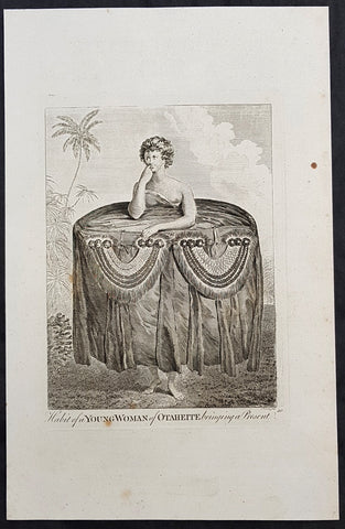
1784 Capt Cook Antique Print a Young Tahitian Presenting Cook a Present in 1777
- Title : Habit of a Young Woman of Otaheite, bringing a present
- Size: 13in x 9in (330mm x 230mm)
- Ref #: 21669
- Date : 1784
- Condition: (A+) Fine Condition
Description:
This fine original copper-plate engraved antique print of a young Tahitian presenting Captain James Cook with a present of a large cloth skirt - visited by Captain James Cook during the third voyage of discovery in 1777 - after John Webber - was published in the 1784 English publication of Cooks third Voyage.
General Definitions:
Paper thickness and quality: - Heavy and stable
Paper color : - off white
Age of map color: -
Colors used: -
General color appearance: -
Paper size: - 13in x 9in (330mm x 230mm)
Plate size: - 13in x 9in (330mm x 230mm)
Margins: - Min 1/2in (12mm)
Imperfections:
Margins: - None
Plate area: - None
Verso: - None
Background:
John Webber was born in London, of Swiss descent. In the spring of 1776 he showed three works at the Royal Academy\'s annual exhibition, where they attracted the attention of Dr Daniel Solander, President of the Royal Society and a friend and colleague of botanist Joseph Banks. Both had sailed with Captain James Cook on his first voyage of exploration in the Pacific aboard the \'Endeavour\', and were looking for a suitable artist to accompany them on a third trip. Solander recommended Webber to the Admiralty, and he was appointed almost immediately.
The voyage commenced on 12 July 1776. Upon his return to London in 1780, Webber submitted about 200 finished works to the Admiralty, which he had made on the voyage. From autumn 1780 until summer 1784, he re-drew many of the drawings and supervised the engravers and printers who were preparing the images for publication, under the direction of Lord Sandwich
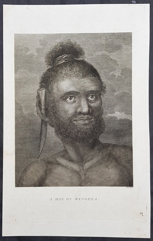
1784 Capt Cook Antique Print Man called Mourooa of Mangaia in the Cook Islands
- Title : A Man of Mangeea
- Size: 13in x 9in (330mm x 230mm)
- Ref #: 21605
- Date : 1784
- Condition: (A+) Fine Condition
Description:
This fine original copper-plate engraved antique print of a man of Mangaia, one of the Cook Islands - visited by Captain James Cook during the third voyage of discovery - after John Webber - was published in the 1784 English publication of Cooks third Voyage.
......Cook reconnoitered the reef surrounding Mangaia, one of the Cook Islands, on 29 March 1777. No landing was made but on the following day, a canoe with paddlers came out to meet the ships.
At length when they had perceived we were going to the Ships they all left us except the man we had in the boat, he tho not without evident signs of fear, accompaned us on board\' Cook\'s Journals III, I, 89.
The portrait was of a native called Mou\'rooa where through Omai\'s services he was questioned about his island.
General Definitions:
Paper thickness and quality: - Heavy and stable
Paper color : - off white
Age of map color: -
Colors used: -
General color appearance: -
Paper size: - 13in x 9in (330mm x 230mm)
Plate size: - 13in x 9in (330mm x 230mm)
Margins: - Min 1/2in (12mm)
Imperfections:
Margins: - None
Plate area: - None
Verso: - None
Background:
John Webber was born in London, of Swiss descent. In the spring of 1776 he showed three works at the Royal Academy\'s annual exhibition, where they attracted the attention of Dr Daniel Solander, President of the Royal Society and a friend and colleague of botanist Joseph Banks. Both had sailed with Captain James Cook on his first voyage of exploration in the Pacific aboard the \'Endeavour\', and were looking for a suitable artist to accompany them on a third trip. Solander recommended Webber to the Admiralty, and he was appointed almost immediately.
The voyage commenced on 12 July 1776. Upon his return to London in 1780, Webber submitted about 200 finished works to the Admiralty, which he had made on the voyage. From autumn 1780 until summer 1784, he re-drew many of the drawings and supervised the engravers and printers who were preparing the images for publication, under the direction of Lord Sandwich
ted.
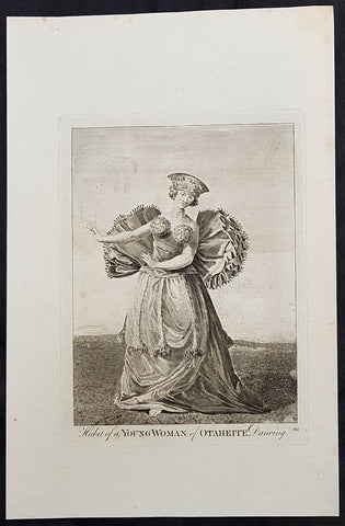
1784 Capt Cook Antique Print of a Tahitian Woman Dancing for Capt. Cook in 1777
- Title : Habit of a Young Woman of Otaheite Dancing
- Size: 13in x 9in (330mm x 230mm)
- Ref #: 21668
- Date : 1784
- Condition: (A) Very Good Condition
Description:
This fine original copper-plate engraved antique print of a young Tahitian dancing for Captain James Cook - visited by Captain James Cook during the third voyage of discovery in 1777 - after John Webber - was published in the 1784 English publication of Cooks third Voyage.
General Definitions:
Paper thickness and quality: - Heavy and stable
Paper color : - off white
Age of map color: -
Colors used: -
General color appearance: -
Paper size: - 13in x 9in (330mm x 230mm)
Plate size: - 13in x 9in (330mm x 230mm)
Margins: - Min 1/2in (12mm)
Imperfections:
Margins: - None
Plate area: - None
Verso: - None
Background:
John Webber was born in London, of Swiss descent. In the spring of 1776 he showed three works at the Royal Academy\'s annual exhibition, where they attracted the attention of Dr Daniel Solander, President of the Royal Society and a friend and colleague of botanist Joseph Banks. Both had sailed with Captain James Cook on his first voyage of exploration in the Pacific aboard the \'Endeavour\', and were looking for a suitable artist to accompany them on a third trip. Solander recommended Webber to the Admiralty, and he was appointed almost immediately.
The voyage commenced on 12 July 1776. Upon his return to London in 1780, Webber submitted about 200 finished works to the Admiralty, which he had made on the voyage. From autumn 1780 until summer 1784, he re-drew many of the drawings and supervised the engravers and printers who were preparing the images for publication, under the direction of Lord Sandwich
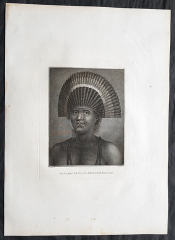
1784 Cook & Webber Large 1st Edition Antique Portrait of Poulaho King of Tonga
Antique Map
- Title : Poulaho, King of the Friendly Islands.
- Size: 21in x 15in (535mm x 385mm)
- Condition: (A+) Fine Condition
- Date : 1784
- Ref #: 82070
Description:
This large beautifully engraved original copper-plate 1st edition antique portrait of Fatafehi Paulaho, the Tui Tonga or Tongan King, visited by Captain Cook in 1777 by John Webber (Cooks official artist on the voyage) was published for the 1784 1st edition and official British Admiralty sanctioned account of Captain Cook’s third and final voyage along with that of Cooks successor Capt. James King......
A Voyage to the Pacific Ocean. Undertaken, by the Command of his Majesty, for making Discoveries in the Northern Hemisphere. To determine The Position and Extent of the West Side of North America; its Distance from Asia; and the Practicability of a Northern Passage to Europe. Performed under the direction of Captains Cook, Clerke, and Gore, In His Majesty\'s Ships the Resolution and Discovery. In the Years 1776, 1777, 1778, 1779, and 1780. In Three Volumes. Vol. I and II written by James Cook, F.R.S. Vol. III by Captain James King, LL.D. and F.R.S
Cooks diary ......On the 28th May 1777, as Cook was about to leave, Ha apai Paulaho came on board and brought me one of their Caps made or at least covered with red feathers. ..These Caps or rather bonnets are made of the tail feathers of the Tropic bird with red feathers of the Paroquets worked upon them or in along with them, they are made so as to tie upon the forehead without any Crown, and have the form of a Semicircle whose raids is 18 or 21 Inches. Cook Journals III, i.117.
Cook had described Paulaho as \\\'the corperate plump fellow we had met with\\\'.
......About Noon a large sailing Canoe came under our Stern in which the Indians on board told us was Fattafee Polaho [Fatafehi Paulaho] King of all the Isles. He brought with him as a present to me two good fat hogs, though not so fat as himself, for he was the most corperate plump fellow we had met with. I found him to be a Sedate sensible man… I asked him down into the Cabbin, some of his attendants objected to this, saying if he went there people would walk over his head and this was never done. I desired Omai to till them I would remove that objection by giving orders that no one should walk on that part of the deck but the chief \'waved the ceremony and walked down with me without any more to do.....
General Definitions:
Paper thickness and quality: - Heavy and stable
Paper color : - off white
Age of map color: -
Colors used: -
General color appearance: -
Paper size: - 21in x 15in (535mm x 385mm)
Plate size: - 21in x 15in (535mm x 385mm)
Margins: - Min 1/2in (12mm)
Imperfections:
Margins: - None
Plate area: - None
Verso: - None
Background:
Tonga officially the Kingdom of Tonga, is a Polynesian sovereign state and archipelago comprising 169 islands, of which 36 are inhabited. The total surface area is about 750 square kilometres (290 sq mi) scattered over 700,000 square kilometres (270,000 sq mi) of the southern Pacific Ocean. It has a population of 107,122 people, of whom 70% reside on the main island of Tongatapu.
The Tongan people first encountered Europeans in 1616 when the Dutch vessel Eendracht, captained by Willem Schouten, made a short visit to trade. Later came other Dutch explorers, including Jacob Le Maire (who called on the northern island of Niuatoputapu); and in 1643 Abel Tasman (who visited Tongatapu and Haapai).
Later noteworthy European visitors included James Cook (Royal Navy) in 1773, 1774, and 1777; Alessandro Malaspina (Spanish Navy) in 1793; the first London missionaries in 1797; and the Wesleyan Methodist Reverend Walter Lawry in 1822.
Tonga became known in the West as the Friendly Islands because of the congenial reception accorded to Captain James Cook on his first visit in 1773. He arrived at the time of the inasi festival, the yearly donation of the First Fruits to the Tui Tonga (the islands paramount chief) and so received an invitation to the festivities. According to the writer William Mariner, the chiefs wanted to kill Cook during the gathering but could not agree on a plan.
Captain James King FRS 1750 – 1784 was an officer of the Royal Navy. He served under James Cook on his last voyage around the world, specialising in taking important astronomical readings using a sextant. After Cook died he helped lead the ships on the remainder of their course, also completing Cooks account of the voyage. He continued his career in the Navy, reaching the rank of post-captain, commanding several ships and serving in the American War of Independence.
King joined HMS Resolution as second lieutenant, sharing the duties of astronomer with Cook, taking astronomical observations on board by sextant and with Larcum Kendals timekeeper K1, to establish the Resolutions position at sea and on shore by sextant or by astronomical quadrant to establish the geographical position of salient points during the course of Cooks surveys. Thus Kings geographical positions were an important contribution to the accuracy of the various surveys carried out during the voyage and his use of the early chronometers helped prove their use at sea for calculation of Longitude. .
Following the death of Cook, King remained in the Resolution but on the death of Charles Clerke, Cooks successor, King was appointed to command HMS Discovery, the Resolutions consort, remaining in her for the rest of the voyage. After his return to England King was very much involved in the publication of the official account of Cooks third voyage, writing the third volume at Woodstock, near Oxford, where his brother Thomas was rector of St Mary Magdalene. But shortly after his return King was promoted Post-captain and appointed commander of HMS Crocodile in the English Channel.
John Webber RA 1751 – 1793 was an English artist who accompanied Captain Cook on his third Pacific expedition. He is best known for his images of Australasia, Hawaii and Alaska.
Webber was born in London, educated in Bern and studied painting at Paris.His father was Abraham Wäber, a Swiss sculptor who had moved to London, and changed his name to Webber before marrying a Mrs Mary Quant in 1744.
Webber served as official artist on James Cooks third voyage of discovery around the Pacific (1776–80) aboard HMS Resolution. At Adventure Bay in January 1777 he did drawings of A Man of Van Diemens Land and A Woman of Van Diemens Land. He also did many drawings of scenes in New Zealand and the South Sea islands. On this voyage, during which Cook lost his life in a fight in Hawaii, Webber became the first European artist to make contact with Hawaii, then called the Sandwich Islands. He made numerous watercolor landscapes of the islands of Kauai and Hawaii, and also portrayed many of the Hawaiian people.
In April 1778, Captain Cooks ships Resolution and Discovery anchored at Ship Cove, now known as Nootka Sound, Vancouver Island, Canada to refit. The crew took observations and recorded encounters with the local people. Webber made watercolour landscapes including Resolution and Discovery in Ship Cove, 1778. His drawings and paintings were engraved for British Admiraltys account of the expedition, which was published in 1784.
Back in England in 1780 Webber exhibited around 50 works at Royal Academy exhibitions between 1784 and 1792, and was elected an associate of the Royal Academy in 1785 and R.A. in 1791. Most of his work were landscapes. Sometimes figures were included as in A Party from H.M.S. Resolution shooting sea horses, which was shown at the academy in 1784, and his The Death of Captain Cook became well known through an engraving of it. Another version of this picture is in the William Dixson gallery at Sydney
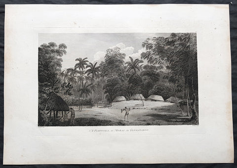
1784 Cook & Webber Large 1st Edition Antique Print Burial Mounds or Langi, Tonga
Antique Map
- Title : A Fiatooka or Morai in Tongataboo
- Size: 21in x 15in (535mm x 385mm)
- Condition: (A+) Fine Condition
- Date : 1784
- Ref #: 82068
Description:
This large beautifully engraved original copper-plate 1st edition antique print of the faitoka or the Royal Langi (burial mounds) in the village of Mua on the main Tongan Island of Tongatapu as seen by Captain James Cook in 1777 and John Webber (Cooks official artist on the voyage) was published for the 1784 1st edition and official British Admiralty sanctioned account of Captain Cook’s third and final voyage along with that of Cooks successor Capt. James King......
A Voyage to the Pacific Ocean. Undertaken, by the Command of his Majesty, for making Discoveries in the Northern Hemisphere. To determine The Position and Extent of the West Side of North America; its Distance from Asia; and the Practicability of a Northern Passage to Europe. Performed under the direction of Captains Cook, Clerke, and Gore, In His Majesty\'s Ships the Resolution and Discovery. In the Years 1776, 1777, 1778, 1779, and 1780. In Three Volumes. Vol. I and II written by James Cook, F.R.S. Vol. III by Captain James King, LL.D. and F.R.S
While on Tongatapu from 10 June to 10 July 1777, Cook and his men recorded Tongan ceremonies and culture. In this view Webber depicts a faitoka (burying ground).
Cooks journal ......\'The Places set apart for burying the dead are raised with Gravel about a foot or two above the level of the Ground, on which stand two or three Houses which are constantly shut up but contain nothing in them; these Ceremonies called in their Language Dano are kept very neat & clean & the Indians are generally despleased at our approaching them.....
General Definitions:
Paper thickness and quality: - Heavy and stable
Paper color : - off white
Age of map color: -
Colors used: -
General color appearance: -
Paper size: - 21in x 15in (535mm x 385mm)
Plate size: - 21in x 15in (535mm x 385mm)
Margins: - Min 1/2in (12mm)
Imperfections:
Margins: - Light soiling
Plate area: - None
Verso: - Light soiling
Background:
Tonga officially the Kingdom of Tonga, is a Polynesian sovereign state and archipelago comprising 169 islands, of which 36 are inhabited. The total surface area is about 750 square kilometres (290 sq mi) scattered over 700,000 square kilometres (270,000 sq mi) of the southern Pacific Ocean. It has a population of 107,122 people, of whom 70% reside on the main island of Tongatapu.
The Tongan people first encountered Europeans in 1616 when the Dutch vessel Eendracht, captained by Willem Schouten, made a short visit to trade. Later came other Dutch explorers, including Jacob Le Maire (who called on the northern island of Niuatoputapu); and in 1643 Abel Tasman (who visited Tongatapu and Haapai).
Later noteworthy European visitors included James Cook (Royal Navy) in 1773, 1774, and 1777; Alessandro Malaspina (Spanish Navy) in 1793; the first London missionaries in 1797; and the Wesleyan Methodist Reverend Walter Lawry in 1822.
Tonga became known in the West as the Friendly Islands because of the congenial reception accorded to Captain James Cook on his first visit in 1773. He arrived at the time of the inasi festival, the yearly donation of the First Fruits to the Tui Tonga (the islands paramount chief) and so received an invitation to the festivities. According to the writer William Mariner, the chiefs wanted to kill Cook during the gathering but could not agree on a plan.
Mu a is a small town in the Hahake (eastern) district on the island of Tongatapu, and it was for centuries the ancient capital of Tonga. It is divided in the villages Lapaha and Tatakamotonga, is close to Talasiu and famous for the ancient langi (royal burial tombs).
Mua was at one time the center of Lapita culture in Tonga (about 2,000 years ago) and later (twelfth to sixteenth century CE) the capital of the Tuʻi Tonga Empire. After the disintegration of the empire it remained the capital of the Tui Tonga (Tonga kings), up to the nineteenth century, but was rather a spiritual centre and no longer a source of political power.
The Tui Tonga and his retinue stayed in Lapaha, his residence being Olotele and Ahofakasiu, while Takuilau was for his wives. Subchiefs and servants on the other hand lived in Tatakamotonga.
When, around 1470, the Tui Tonga line started to lose power to the Tui Ha atakalaua, and another century later to the Tu i Kanokupolu, chiefs belonging to these lines were not welcome in Mu a, and had to stay on the low-lying coastal areas, separated from the real chiefs (i.e. those belonging to the Tu i Tonga) by the Hala Fonuamoa (dry land road). The former became known as the kauhalalalo (low road people) and the latter as the kauhala uta (inland road people), which nowadays are still two important moieties in Tonga.
Whatever political power the Tu i Tonga yielded to their rivals, they gained in spiritual power, and as a kind of high priest they were perhaps even more awesome than as kings. When a Tu i Tonga died he was buried in one of the huge tomb hills, known as langi, of which there are still at least two dozen in Lapaha. The Tu i Haʻatakalaua were also buried in such tombs, but they are called fale instead.
The langi are big, artificial hills surrounded by huge slabs of coral rock, usually in three or more tiered layers. These slabs were quarried from several places along the coast of Tongatapu or neighbouring minor islands. The waves of the sea made them over the centuries, by compacting coral sand into layers of 10 to 20 centimetres (3.9 to 7.9 inches) thick. They were only to be dug out and then transported by boat to the building site. Nevertheless, the accuracy by which the slabs were cut to shape so that they fit along each other with barely any space to spare is remarkable.
One of the best-preserved langi is the Paepae-o-Tele a, which is even more remarkable as the slabs along the corner really have an L shape.
The story that the slabs were moved by magic means from Uvea to Tonga is just a myth. Uvea is volcanic and has not got the proper geology. This fact has always been known, as shown, for example by a stanza of the poem named Laveofo from around the 18th century by Tufui.
Captain James King FRS 1750 – 1784 was an officer of the Royal Navy. He served under James Cook on his last voyage around the world, specialising in taking important astronomical readings using a sextant. After Cook died he helped lead the ships on the remainder of their course, also completing Cooks account of the voyage. He continued his career in the Navy, reaching the rank of post-captain, commanding several ships and serving in the American War of Independence.
King joined HMS Resolution as second lieutenant, sharing the duties of astronomer with Cook, taking astronomical observations on board by sextant and with Larcum Kendals timekeeper K1, to establish the Resolutions position at sea and on shore by sextant or by astronomical quadrant to establish the geographical position of salient points during the course of Cooks surveys. Thus Kings geographical positions were an important contribution to the accuracy of the various surveys carried out during the voyage and his use of the early chronometers helped prove their use at sea for calculation of Longitude. .
Following the death of Cook, King remained in the Resolution but on the death of Charles Clerke, Cooks successor, King was appointed to command HMS Discovery, the Resolutions consort, remaining in her for the rest of the voyage. After his return to England King was very much involved in the publication of the official account of Cooks third voyage, writing the third volume at Woodstock, near Oxford, where his brother Thomas was rector of St Mary Magdalene. But shortly after his return King was promoted Post-captain and appointed commander of HMS Crocodile in the English Channel.
John Webber RA 1751 – 1793 was an English artist who accompanied Captain Cook on his third Pacific expedition. He is best known for his images of Australasia, Hawaii and Alaska.
Webber was born in London, educated in Bern and studied painting at Paris.His father was Abraham Wäber, a Swiss sculptor who had moved to London, and changed his name to Webber before marrying a Mrs Mary Quant in 1744.
Webber served as official artist on James Cooks third voyage of discovery around the Pacific (1776–80) aboard HMS Resolution. At Adventure Bay in January 1777 he did drawings of A Man of Van Diemens Land and A Woman of Van Diemens Land. He also did many drawings of scenes in New Zealand and the South Sea islands. On this voyage, during which Cook lost his life in a fight in Hawaii, Webber became the first European artist to make contact with Hawaii, then called the Sandwich Islands. He made numerous watercolor landscapes of the islands of Kauai and Hawaii, and also portrayed many of the Hawaiian people.
In April 1778, Captain Cooks ships Resolution and Discovery anchored at Ship Cove, now known as Nootka Sound, Vancouver Island, Canada to refit. The crew took observations and recorded encounters with the local people. Webber made watercolour landscapes including Resolution and Discovery in Ship Cove, 1778. His drawings and paintings were engraved for British Admiraltys account of the expedition, which was published in 1784.
Back in England in 1780 Webber exhibited around 50 works at Royal Academy exhibitions between 1784 and 1792, and was elected an associate of the Royal Academy in 1785 and R.A. in 1791. Most of his work were landscapes. Sometimes figures were included as in A Party from H.M.S. Resolution shooting sea horses, which was shown at the academy in 1784, and his The Death of Captain Cook became well known through an engraving of it. Another version of this picture is in the William Dixson gallery at Sydney
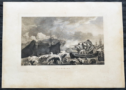
1784 Cook & Webber Large 1st Edition Antique Print Hunting Walrus in Alaska
- Title : Sea Horses
- Size: 21in x 15in (535mm x 385mm)
- Condition: (A) Very Good Condition
- Date : 1784
- Ref #: 82064
Description:
This large beautifully engraved original copper-plate 1st edition antique print of the crew of HMS Resolution hunting Walrus in Arctic Alaska in 1778 by John Webber (Cooks official artist on the voyage) & John Heath was later published for the 1784 1st edition and official British Admiralty sanctioned account of Captain Cook’s third and final voyage along with that of Cooks successor Capt. James King......
A Voyage to the Pacific Ocean. Undertaken, by the Command of his Majesty, for making Discoveries in the Northern Hemisphere. To determine The Position and Extent of the West Side of North America; its Distance from Asia; and the Practicability of a Northern Passage to Europe. Performed under the direction of Captains Cook, Clerke, and Gore, In His Majesty\'s Ships the Resolution and Discovery. In the Years 1776, 1777, 1778, 1779, and 1780. In Three Volumes. Vol. I and II written by James Cook, F.R.S. Vol. III by Captain James King, LL.D. and F.R.S
From 11 August to 3 September, 1778 Cook\'s ships had a harrowing time sailing through the Arctics ice covered seas and were in need of supplies.
On the 19th August Cook sent two boats to hunt the large colony of walruses that had been seen from the ship. By seven that evening seven were brought on board the Resolution.
............The sea horse, also known as the morse, is now called the walrus. Ledyard described them as, between a quadrupede and a fish, their heads are somewhat like those of a dog, without ears, except two large white tusks that project downward from the upper jaw… they have a thick skin like that of a horse. Gilbert considered the name sea horse. Why they are so called I cant imagine, for they bear not the smallest resemblance to that animal. Cook Journals III, i, 419.
General Definitions:
Paper thickness and quality: - Heavy and stable
Paper color : - off white
Age of map color: -
Colors used: -
General color appearance: -
Paper size: - 21in x 15in (535mm x 385mm)
Plate size: - 21in x 15in (535mm x 385mm)
Margins: - Min 1/2in (12mm)
Imperfections:
Margins: - Age toning
Plate area: - Age toning
Verso: - Age toning
Background:
Prince William Sound is located on the south coast of the U.S. state of Alaska. It is located on the east side of the Kenai Peninsula, its largest port is Valdez, at the southern terminus of the Trans-Alaska Pipeline System. Other settlements on the sound contain numerous small islands, including Cordova and Whittier plus the Alaska native villages of Chenega and Tatitlek.
James Cook entered Prince William Sound in 1778 and named it Sandwich Sound, after his patron the Earl of Sandwich. The name was changed to honour King George III third son, Prince William Henry, then aged 13 and serving as a midshipman in the Royal Navy.
Captain James King FRS 1750 – 1784 was an officer of the Royal Navy. He served under James Cook on his last voyage around the world, specialising in taking important astronomical readings using a sextant. After Cook died he helped lead the ships on the remainder of their course, also completing Cooks account of the voyage. He continued his career in the Navy, reaching the rank of post-captain, commanding several ships and serving in the American War of Independence.
King joined HMS Resolution as second lieutenant, sharing the duties of astronomer with Cook, taking astronomical observations on board by sextant and with Larcum Kendals timekeeper K1, to establish the Resolutions position at sea and on shore by sextant or by astronomical quadrant to establish the geographical position of salient points during the course of Cooks surveys. Thus Kings geographical positions were an important contribution to the accuracy of the various surveys carried out during the voyage and his use of the early chronometers helped prove their use at sea for calculation of Longitude. .
Following the death of Cook, King remained in the Resolution but on the death of Charles Clerke, Cooks successor, King was appointed to command HMS Discovery, the Resolutions consort, remaining in her for the rest of the voyage. After his return to England King was very much involved in the publication of the official account of Cooks third voyage, writing the third volume at Woodstock, near Oxford, where his brother Thomas was rector of St Mary Magdalene. But shortly after his return King was promoted Post-captain and appointed commander of HMS Crocodile in the English Channel.
John Webber RA 1751 – 1793 was an English artist who accompanied Captain Cook on his third Pacific expedition. He is best known for his images of Australasia, Hawaii and Alaska.
Webber was born in London, educated in Bern and studied painting at Paris.His father was Abraham Wäber, a Swiss sculptor who had moved to London, and changed his name to Webber before marrying a Mrs Mary Quant in 1744.
Webber served as official artist on James Cooks third voyage of discovery around the Pacific (1776–80) aboard HMS Resolution. At Adventure Bay in January 1777 he did drawings of A Man of Van Diemens Land and A Woman of Van Diemens Land. He also did many drawings of scenes in New Zealand and the South Sea islands. On this voyage, during which Cook lost his life in a fight in Hawaii, Webber became the first European artist to make contact with Hawaii, then called the Sandwich Islands. He made numerous watercolor landscapes of the islands of Kauai and Hawaii, and also portrayed many of the Hawaiian people.
In April 1778, Captain Cooks ships Resolution and Discovery anchored at Ship Cove, now known as Nootka Sound, Vancouver Island, Canada to refit. The crew took observations and recorded encounters with the local people. Webber made watercolour landscapes including Resolution and Discovery in Ship Cove, 1778. His drawings and paintings were engraved for British Admiraltys account of the expedition, which was published in 1784.
Back in England in 1780 Webber exhibited around 50 works at Royal Academy exhibitions between 1784 and 1792, and was elected an associate of the Royal Academy in 1785 and R.A. in 1791. Most of his work were landscapes. Sometimes figures were included as in A Party from H.M.S. Resolution shooting sea horses, which was shown at the academy in 1784, and his The Death of Captain Cook became well known through an engraving of it. Another version of this picture is in the William Dixson gallery at Sydney
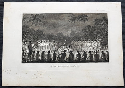
1784 Cook & Webber Large 1st Edition Antique Print Men Dancing Lifuka Isle Tonga
Antique Map
- Title : Night Dance by Men in Hapaee
- Size: 21in x 15in (535mm x 385mm)
- Condition: (A+) Fine Condition
- Date : 1784
- Ref #: 82066
Description:
This large beautifully engraved original copper-plate 1st edition antique print of Captain Cook (seen in the foreground) and his men watching men dancing at night on the Island of Lifuka, in the Ha apai island group of Tonga, at the time of Cooks visit in 1777 as drawn by John Webber (Cooks official artist on the voyage) was published for the 1784 1st edition and official British Admiralty sanctioned account of Captain Cook’s third and final voyage along with that of Cooks successor Capt. James King......
A Voyage to the Pacific Ocean. Undertaken, by the Command of his Majesty, for making Discoveries in the Northern Hemisphere. To determine The Position and Extent of the West Side of North America; its Distance from Asia; and the Practicability of a Northern Passage to Europe. Performed under the direction of Captains Cook, Clerke, and Gore, In His Majesty\'s Ships the Resolution and Discovery. In the Years 1776, 1777, 1778, 1779, and 1780. In Three Volumes. Vol. I and II written by James Cook, F.R.S. Vol. III by Captain James King, LL.D. and F.R.S
General Definitions:
Paper thickness and quality: - Heavy and stable
Paper color : - off white
Age of map color: -
Colors used: -
General color appearance: -
Paper size: - 21in x 15in (535mm x 385mm)
Plate size: - 21in x 15in (535mm x 385mm)
Margins: - Min 1/2in (12mm)
Imperfections:
Margins: - Light soiling
Plate area: - None
Verso: - Light soiling
Background:
Tonga officially the Kingdom of Tonga, is a Polynesian sovereign state and archipelago comprising 169 islands, of which 36 are inhabited. The total surface area is about 750 square kilometres (290 sq mi) scattered over 700,000 square kilometres (270,000 sq mi) of the southern Pacific Ocean. It has a population of 107,122 people, of whom 70% reside on the main island of Tongatapu.
The Tongan people first encountered Europeans in 1616 when the Dutch vessel Eendracht, captained by Willem Schouten, made a short visit to trade. Later came other Dutch explorers, including Jacob Le Maire (who called on the northern island of Niuatoputapu); and in 1643 Abel Tasman (who visited Tongatapu and Haapai).
Later noteworthy European visitors included James Cook (Royal Navy) in 1773, 1774, and 1777; Alessandro Malaspina (Spanish Navy) in 1793; the first London missionaries in 1797; and the Wesleyan Methodist Reverend Walter Lawry in 1822.
Tonga became known in the West as the Friendly Islands because of the congenial reception accorded to Captain James Cook on his first visit in 1773. He arrived at the time of the inasi festival, the yearly donation of the First Fruits to the Tui Tonga (the islands paramount chief) and so received an invitation to the festivities. According to the writer William Mariner, the chiefs wanted to kill Cook during the gathering but could not agree on a plan.
Lifuka is an island in the Kingdom of Tonga. It is located within the Ha apai Group in the centre of the country, to northeast of the national capital of Nuku alofa.
Lifuka is the place where Captain James Cook dubbed Tonga The Friendly Islands. Tofua is where the mutiny on the Bounty occurred in 1789; this active volcanic island lies approximately forty nautical miles west of Lifuka. The Cpt. Bligh voyage stands as the longest successful passage ever recorded in an open boat without modern navigational aids.
Captain James King FRS 1750 – 1784 was an officer of the Royal Navy. He served under James Cook on his last voyage around the world, specialising in taking important astronomical readings using a sextant. After Cook died he helped lead the ships on the remainder of their course, also completing Cooks account of the voyage. He continued his career in the Navy, reaching the rank of post-captain, commanding several ships and serving in the American War of Independence.
King joined HMS Resolution as second lieutenant, sharing the duties of astronomer with Cook, taking astronomical observations on board by sextant and with Larcum Kendals timekeeper K1, to establish the Resolutions position at sea and on shore by sextant or by astronomical quadrant to establish the geographical position of salient points during the course of Cooks surveys. Thus Kings geographical positions were an important contribution to the accuracy of the various surveys carried out during the voyage and his use of the early chronometers helped prove their use at sea for calculation of Longitude. .
Following the death of Cook, King remained in the Resolution but on the death of Charles Clerke, Cooks successor, King was appointed to command HMS Discovery, the Resolutions consort, remaining in her for the rest of the voyage. After his return to England King was very much involved in the publication of the official account of Cooks third voyage, writing the third volume at Woodstock, near Oxford, where his brother Thomas was rector of St Mary Magdalene. But shortly after his return King was promoted Post-captain and appointed commander of HMS Crocodile in the English Channel.
John Webber RA 1751 – 1793 was an English artist who accompanied Captain Cook on his third Pacific expedition. He is best known for his images of Australasia, Hawaii and Alaska.
Webber was born in London, educated in Bern and studied painting at Paris.His father was Abraham Wäber, a Swiss sculptor who had moved to London, and changed his name to Webber before marrying a Mrs Mary Quant in 1744.
Webber served as official artist on James Cooks third voyage of discovery around the Pacific (1776–80) aboard HMS Resolution. At Adventure Bay in January 1777 he did drawings of A Man of Van Diemens Land and A Woman of Van Diemens Land. He also did many drawings of scenes in New Zealand and the South Sea islands. On this voyage, during which Cook lost his life in a fight in Hawaii, Webber became the first European artist to make contact with Hawaii, then called the Sandwich Islands. He made numerous watercolor landscapes of the islands of Kauai and Hawaii, and also portrayed many of the Hawaiian people.
In April 1778, Captain Cooks ships Resolution and Discovery anchored at Ship Cove, now known as Nootka Sound, Vancouver Island, Canada to refit. The crew took observations and recorded encounters with the local people. Webber made watercolour landscapes including Resolution and Discovery in Ship Cove, 1778. His drawings and paintings were engraved for British Admiraltys account of the expedition, which was published in 1784.
Back in England in 1780 Webber exhibited around 50 works at Royal Academy exhibitions between 1784 and 1792, and was elected an associate of the Royal Academy in 1785 and R.A. in 1791. Most of his work were landscapes. Sometimes figures were included as in A Party from H.M.S. Resolution shooting sea horses, which was shown at the academy in 1784, and his The Death of Captain Cook became well known through an engraving of it. Another version of this picture is in the William Dixson gallery at Sydney
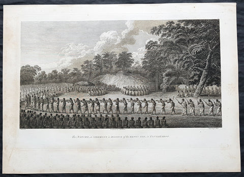
1784 Cook & Webber Large 1st Edition Antique Print of Inasi Ceremony Mu'a, Tonga
- Title : Natche, a Ceremony in Honour of the Kings Son in Tongataboo
- Size: 21in x 15in (535mm x 385mm)
- Condition: (A+) Fine Condition
- Date : 1784
- Ref #: 82067
Description:
This large beautifully engraved original copper-plate 1st edition antique print of possibly the coming of age or Inasi ceremony for the son of the King of Tonga in the village of Mua on the main Tongan Island of Tongatapu, at the time of Captain Cooks visit in 1777 as drawn by John Webber (Cooks official artist on the voyage) was published for the 1784 1st edition and official British Admiralty sanctioned account of Captain Cook’s third and final voyage along with that of Cooks successor Capt. James King......
A Voyage to the Pacific Ocean. Undertaken, by the Command of his Majesty, for making Discoveries in the Northern Hemisphere. To determine The Position and Extent of the West Side of North America; its Distance from Asia; and the Practicability of a Northern Passage to Europe. Performed under the direction of Captains Cook, Clerke, and Gore, In His Majesty\'s Ships the Resolution and Discovery. In the Years 1776, 1777, 1778, 1779, and 1780. In Three Volumes. Vol. I and II written by James Cook, F.R.S. Vol. III by Captain James King, LL.D. and F.R.S
While on Tongatapu from 10 June to 10 July 1777, Cook and his men recorded Tongan ceremonies and culture.
The most unusual and extraordinary ceremony observed during Cook\'s stay at Tongatapu was the Inasi ceremony which took place at Mua from 8 to 9 July. The ceremony was centred upon the son of Fatafehi Paulaho, the sacred King of Tonga (Tui Tonga), and was probably performed in honour of his coming of age. Several thousand were involved, most of whom entered the performing area with sticks about four feet long. They approached a shelter or small hut in which Paulaho, his son and other people of distinction were seated.
General Definitions:
Paper thickness and quality: - Heavy and stable
Paper color : - off white
Age of map color: -
Colors used: -
General color appearance: -
Paper size: - 21in x 15in (535mm x 385mm)
Plate size: - 21in x 15in (535mm x 385mm)
Margins: - Min 1/2in (12mm)
Imperfections:
Margins: - Light soiling
Plate area: - None
Verso: - Light soiling
Background:
Tonga officially the Kingdom of Tonga, is a Polynesian sovereign state and archipelago comprising 169 islands, of which 36 are inhabited. The total surface area is about 750 square kilometres (290 sq mi) scattered over 700,000 square kilometres (270,000 sq mi) of the southern Pacific Ocean. It has a population of 107,122 people, of whom 70% reside on the main island of Tongatapu.
The Tongan people first encountered Europeans in 1616 when the Dutch vessel Eendracht, captained by Willem Schouten, made a short visit to trade. Later came other Dutch explorers, including Jacob Le Maire (who called on the northern island of Niuatoputapu); and in 1643 Abel Tasman (who visited Tongatapu and Haapai).
Later noteworthy European visitors included James Cook (Royal Navy) in 1773, 1774, and 1777; Alessandro Malaspina (Spanish Navy) in 1793; the first London missionaries in 1797; and the Wesleyan Methodist Reverend Walter Lawry in 1822.
Tonga became known in the West as the Friendly Islands because of the congenial reception accorded to Captain James Cook on his first visit in 1773. He arrived at the time of the inasi festival, the yearly donation of the First Fruits to the Tui Tonga (the islands paramount chief) and so received an invitation to the festivities. According to the writer William Mariner, the chiefs wanted to kill Cook during the gathering but could not agree on a plan.
Mu a is a small town in the Hahake (eastern) district on the island of Tongatapu, and it was for centuries the ancient capital of Tonga. It is divided in the villages Lapaha and Tatakamotonga, is close to Talasiu and famous for the ancient langi (royal burial tombs).
Mua was at one time the center of Lapita culture in Tonga (about 2,000 years ago) and later (twelfth to sixteenth century CE) the capital of the Tuʻi Tonga Empire. After the disintegration of the empire it remained the capital of the Tui Tonga (Tonga kings), up to the nineteenth century, but was rather a spiritual centre and no longer a source of political power.
The Tui Tonga and his retinue stayed in Lapaha, his residence being Olotele and Ahofakasiu, while Takuilau was for his wives. Subchiefs and servants on the other hand lived in Tatakamotonga.
When, around 1470, the Tui Tonga line started to lose power to the Tui Ha atakalaua, and another century later to the Tu i Kanokupolu, chiefs belonging to these lines were not welcome in Mu a, and had to stay on the low-lying coastal areas, separated from the real chiefs (i.e. those belonging to the Tu i Tonga) by the Hala Fonuamoa (dry land road). The former became known as the kauhalalalo (low road people) and the latter as the kauhala uta (inland road people), which nowadays are still two important moieties in Tonga.
Whatever political power the Tu i Tonga yielded to their rivals, they gained in spiritual power, and as a kind of high priest they were perhaps even more awesome than as kings. When a Tu i Tonga died he was buried in one of the huge tomb hills, known as langi, of which there are still at least two dozen in Lapaha. The Tu i Haʻatakalaua were also buried in such tombs, but they are called fale instead.
The langi are big, artificial hills surrounded by huge slabs of coral rock, usually in three or more tiered layers. These slabs were quarried from several places along the coast of Tongatapu or neighbouring minor islands. The waves of the sea made them over the centuries, by compacting coral sand into layers of 10 to 20 centimetres (3.9 to 7.9 inches) thick. They were only to be dug out and then transported by boat to the building site. Nevertheless, the accuracy by which the slabs were cut to shape so that they fit along each other with barely any space to spare is remarkable.
One of the best-preserved langi is the Paepae-o-Tele a, which is even more remarkable as the slabs along the corner really have an L shape.
The story that the slabs were moved by magic means from Uvea to Tonga is just a myth. Uvea is volcanic and has not got the proper geology. This fact has always been known, as shown, for example by a stanza of the poem named Laveofo from around the 18th century by Tufui.
Captain James King FRS 1750 – 1784 was an officer of the Royal Navy. He served under James Cook on his last voyage around the world, specialising in taking important astronomical readings using a sextant. After Cook died he helped lead the ships on the remainder of their course, also completing Cooks account of the voyage. He continued his career in the Navy, reaching the rank of post-captain, commanding several ships and serving in the American War of Independence.
King joined HMS Resolution as second lieutenant, sharing the duties of astronomer with Cook, taking astronomical observations on board by sextant and with Larcum Kendals timekeeper K1, to establish the Resolutions position at sea and on shore by sextant or by astronomical quadrant to establish the geographical position of salient points during the course of Cooks surveys. Thus Kings geographical positions were an important contribution to the accuracy of the various surveys carried out during the voyage and his use of the early chronometers helped prove their use at sea for calculation of Longitude. .
Following the death of Cook, King remained in the Resolution but on the death of Charles Clerke, Cooks successor, King was appointed to command HMS Discovery, the Resolutions consort, remaining in her for the rest of the voyage. After his return to England King was very much involved in the publication of the official account of Cooks third voyage, writing the third volume at Woodstock, near Oxford, where his brother Thomas was rector of St Mary Magdalene. But shortly after his return King was promoted Post-captain and appointed commander of HMS Crocodile in the English Channel.
John Webber RA 1751 – 1793 was an English artist who accompanied Captain Cook on his third Pacific expedition. He is best known for his images of Australasia, Hawaii and Alaska.
Webber was born in London, educated in Bern and studied painting at Paris.His father was Abraham Wäber, a Swiss sculptor who had moved to London, and changed his name to Webber before marrying a Mrs Mary Quant in 1744.
Webber served as official artist on James Cooks third voyage of discovery around the Pacific (1776–80) aboard HMS Resolution. At Adventure Bay in January 1777 he did drawings of A Man of Van Diemens Land and A Woman of Van Diemens Land. He also did many drawings of scenes in New Zealand and the South Sea islands. On this voyage, during which Cook lost his life in a fight in Hawaii, Webber became the first European artist to make contact with Hawaii, then called the Sandwich Islands. He made numerous watercolor landscapes of the islands of Kauai and Hawaii, and also portrayed many of the Hawaiian people.
In April 1778, Captain Cooks ships Resolution and Discovery anchored at Ship Cove, now known as Nootka Sound, Vancouver Island, Canada to refit. The crew took observations and recorded encounters with the local people. Webber made watercolour landscapes including Resolution and Discovery in Ship Cove, 1778. His drawings and paintings were engraved for British Admiraltys account of the expedition, which was published in 1784.
Back in England in 1780 Webber exhibited around 50 works at Royal Academy exhibitions between 1784 and 1792, and was elected an associate of the Royal Academy in 1785 and R.A. in 1791. Most of his work were landscapes. Sometimes figures were included as in A Party from H.M.S. Resolution shooting sea horses, which was shown at the academy in 1784, and his The Death of Captain Cook became well known through an engraving of it. Another version of this picture is in the William Dixson gallery at Sydney
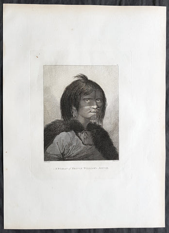
1784 Cook & Webber Large Antique Portrait Woman of Prince William Sound, Alaska
Antique Map
- Title : A Woman of Prince William Sound
- Size: 21in x 15in (535mm x 385mm)
- Condition: (A+) Fine Condition
- Date : 1784
- Ref #: 82071
Description:
This large beautifully engraved original copper-plate 1st edition antique portrait of a woman of Prince William Sound Alaska, visited by Captain Cooks ships HMS Resolution and Discovery in Snug Corner Cove, Prince William Sound, Alaska, in 1778 was drawn by the official artist on Cooks crew, John Webber, and later published for the 1784 1st edition and official British Admiralty sanctioned account of Captain Cook’s third and final voyage along with that of Cooks successor Capt. James King......
A Voyage to the Pacific Ocean. Undertaken, by the Command of his Majesty, for making Discoveries in the Northern Hemisphere. To determine The Position and Extent of the West Side of North America; its Distance from Asia; and the Practicability of a Northern Passage to Europe. Performed under the direction of Captains Cook, Clerke, and Gore, In His Majesty\'s Ships the Resolution and Discovery. In the Years 1776, 1777, 1778, 1779, and 1780. In Three Volumes. Vol. I and II written by James Cook, F.R.S. Vol. III by Captain James King, LL.D. and F.R.S
May 1778.........On the 12th at nine in the morning, wrote Ledyard, we entered an inlet… at six in the evening perceiving bad weather approaching… both ships anchored… The pinnace of the Resolution with the first lieutenant, some other gentlemen and myself went to the opposite shore to shoot some wild fowl. The first lieutenant was John Gore. The inlet was named Sandwich Sound by Cook, after the Earl of Sandwich, First Lord of the Admiralty, but in the published version of his journal the name appeared as Prince Williams Sound, after George IIIs third son, Duke of Clarence, later William IV. The ships had anchored off Cape Hinchinbrook, named after the country seat of the Earl of Sandwich.
Some local inhabitants appeared and came aboard the ships. Clerke gave them a Glass Bowl, with which they seem\\\'d much delighted, and toss\\\'d me, in spight of all my motions to the contrary, one of their Frocks, which was made of Water fowl Skins, and exceedingly well calculated, to keep out both Wet & Cold; then, both Boats put off and made for the Shore, paddling & singing with all the Jollity imaginable. We either found these good folks on of their Jubilee Days, or they are a very happy Race.
They sailed on until Cook found a fine bay or rather harbour which he later called a very snug place and named Snug Corner Bay. Samwell on 14th wrote we secured the Ship with the small Anchor; in carrying this out in the Launch one of the Sailors was so unfortunate as to get his Leg entangled in the Buoy rope which carried him down with the Anchor, however he disengaged himself when he got to the bottom & came up again & saved his Life tho\\\' he had his Leg broke in a very dangerous Manner.
We heeled the ship to port wrote Gilbert, to examine the leak on the starboard buttock… it being close below the wale and occasioned by some of the seems being very open and the oakum quite rotten and great part of it got out. In two days we repaired this defect being obliged to put two and half inch rope along the seams which were too wide for caulking.
On 18th King noted two boats, one with Mr Gore & the other with the Master, were sent away, the first to explore the Inlet to the Noward: the other to the N end of the Island near us to make observations on the tides. William Bligh was master on the Resolution. They returned by Dusk, Mr Gore had proceeded up the Inlet & perceivd that it took a direction to the NE, & he thought that it bid fair for opening a communication to some other Sea; but the mate that was with him form\\\'d a very contrary opinion… the Captn judg\\\'d it the Wisest way to lose no more time, being certain that if we were amongst Islands, we shoud soon come to more Passages. Henry Roberts was the masters mate referred to here. Cook had sent him and others to sketch out the parts they examined.
General Definitions:
Paper thickness and quality: - Heavy and stable
Paper color : - off white
Age of map color: -
Colors used: -
General color appearance: -
Paper size: - 21in x 15in (535mm x 385mm)
Plate size: - 21in x 15in (535mm x 385mm)
Margins: - Min 1/2in (12mm)
Imperfections:
Margins: - Light soiling in margins
Plate area: - None
Verso: - None
Background:
Prince William Sound is located on the south coast of the U.S. state of Alaska. It is located on the east side of the Kenai Peninsula, its largest port is Valdez, at the southern terminus of the Trans-Alaska Pipeline System. Other settlements on the sound contain numerous small islands, including Cordova and Whittier plus the Alaska native villages of Chenega and Tatitlek.
James Cook entered Prince William Sound in 1778 and named it Sandwich Sound, after his patron the Earl of Sandwich. The name was changed to honour King George III third son, Prince William Henry, then aged 13 and serving as a midshipman in the Royal Navy.
Captain James King FRS 1750 – 1784 was an officer of the Royal Navy. He served under James Cook on his last voyage around the world, specialising in taking important astronomical readings using a sextant. After Cook died he helped lead the ships on the remainder of their course, also completing Cooks account of the voyage. He continued his career in the Navy, reaching the rank of post-captain, commanding several ships and serving in the American War of Independence.
King joined HMS Resolution as second lieutenant, sharing the duties of astronomer with Cook, taking astronomical observations on board by sextant and with Larcum Kendals timekeeper K1, to establish the Resolutions position at sea and on shore by sextant or by astronomical quadrant to establish the geographical position of salient points during the course of Cooks surveys. Thus Kings geographical positions were an important contribution to the accuracy of the various surveys carried out during the voyage and his use of the early chronometers helped prove their use at sea for calculation of Longitude. .
Following the death of Cook, King remained in the Resolution but on the death of Charles Clerke, Cooks successor, King was appointed to command HMS Discovery, the Resolutions consort, remaining in her for the rest of the voyage. After his return to England King was very much involved in the publication of the official account of Cooks third voyage, writing the third volume at Woodstock, near Oxford, where his brother Thomas was rector of St Mary Magdalene. But shortly after his return King was promoted Post-captain and appointed commander of HMS Crocodile in the English Channel.
John Webber RA 1751 – 1793 was an English artist who accompanied Captain Cook on his third Pacific expedition. He is best known for his images of Australasia, Hawaii and Alaska.
Webber was born in London, educated in Bern and studied painting at Paris.His father was Abraham Wäber, a Swiss sculptor who had moved to London, and changed his name to Webber before marrying a Mrs Mary Quant in 1744.
Webber served as official artist on James Cooks third voyage of discovery around the Pacific (1776–80) aboard HMS Resolution. At Adventure Bay in January 1777 he did drawings of A Man of Van Diemens Land and A Woman of Van Diemens Land. He also did many drawings of scenes in New Zealand and the South Sea islands. On this voyage, during which Cook lost his life in a fight in Hawaii, Webber became the first European artist to make contact with Hawaii, then called the Sandwich Islands. He made numerous watercolor landscapes of the islands of Kauai and Hawaii, and also portrayed many of the Hawaiian people.
In April 1778, Captain Cooks ships Resolution and Discovery anchored at Ship Cove, now known as Nootka Sound, Vancouver Island, Canada to refit. The crew took observations and recorded encounters with the local people. Webber made watercolour landscapes including Resolution and Discovery in Ship Cove, 1778. His drawings and paintings were engraved for British Admiraltys account of the expedition, which was published in 1784.
Back in England in 1780 Webber exhibited around 50 works at Royal Academy exhibitions between 1784 and 1792, and was elected an associate of the Royal Academy in 1785 and R.A. in 1791. Most of his work were landscapes. Sometimes figures were included as in A Party from H.M.S. Resolution shooting sea horses, which was shown at the academy in 1784, and his The Death of Captain Cook became well known through an engraving of it. Another version of this picture is in the William Dixson gallery at Sydney
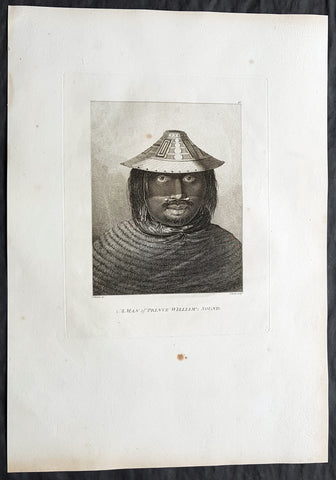
1784 Cook & Webber Large Antique Print of a Man of Prince William Sound, Alaska
Antique Map
- Title : A Man of Prince William Sound
- Size: 21in x 15in (535mm x 385mm)
- Condition: (A+) Fine Condition
- Date : 1784
- Ref #: 82072
Description:
This large beautifully engraved original copper-plate 1st edition antique portrait of a man of Prince William Sound Alaska, visited by Captain Cooks ships HMS Resolution and Discovery in Snug Corner Cove, Prince William Sound, Alaska, in 1778 was drawn by the official artist on Cooks crew, John Webber, and later published for the 1784 1st edition and official British Admiralty sanctioned account of Captain Cook’s third and final voyage along with that of Cooks successor Capt. James King......
A Voyage to the Pacific Ocean. Undertaken, by the Command of his Majesty, for making Discoveries in the Northern Hemisphere. To determine The Position and Extent of the West Side of North America; its Distance from Asia; and the Practicability of a Northern Passage to Europe. Performed under the direction of Captains Cook, Clerke, and Gore, In His Majesty\'s Ships the Resolution and Discovery. In the Years 1776, 1777, 1778, 1779, and 1780. In Three Volumes. Vol. I and II written by James Cook, F.R.S. Vol. III by Captain James King, LL.D. and F.R.S
May 1778.........On the 12th at nine in the morning, wrote Ledyard, we entered an inlet… at six in the evening perceiving bad weather approaching… both ships anchored… The pinnace of the Resolution with the first lieutenant, some other gentlemen and myself went to the opposite shore to shoot some wild fowl. The first lieutenant was John Gore. The inlet was named Sandwich Sound by Cook, after the Earl of Sandwich, First Lord of the Admiralty, but in the published version of his journal the name appeared as Prince Williams Sound, after George IIIs third son, Duke of Clarence, later William IV. The ships had anchored off Cape Hinchinbrook, named after the country seat of the Earl of Sandwich.
Some local inhabitants appeared and came aboard the ships. Clerke gave them a Glass Bowl, with which they seem\\\'d much delighted, and toss\\\'d me, in spight of all my motions to the contrary, one of their Frocks, which was made of Water fowl Skins, and exceedingly well calculated, to keep out both Wet & Cold; then, both Boats put off and made for the Shore, paddling & singing with all the Jollity imaginable. We either found these good folks on of their Jubilee Days, or they are a very happy Race.
They sailed on until Cook found a fine bay or rather harbour which he later called a very snug place and named Snug Corner Bay. Samwell on 14th wrote we secured the Ship with the small Anchor; in carrying this out in the Launch one of the Sailors was so unfortunate as to get his Leg entangled in the Buoy rope which carried him down with the Anchor, however he disengaged himself when he got to the bottom & came up again & saved his Life tho\\\' he had his Leg broke in a very dangerous Manner.
We heeled the ship to port wrote Gilbert, to examine the leak on the starboard buttock… it being close below the wale and occasioned by some of the seems being very open and the oakum quite rotten and great part of it got out. In two days we repaired this defect being obliged to put two and half inch rope along the seams which were too wide for caulking.
On 18th King noted two boats, one with Mr Gore & the other with the Master, were sent away, the first to explore the Inlet to the Noward: the other to the N end of the Island near us to make observations on the tides. William Bligh was master on the Resolution. They returned by Dusk, Mr Gore had proceeded up the Inlet & perceivd that it took a direction to the NE, & he thought that it bid fair for opening a communication to some other Sea; but the mate that was with him form\\\'d a very contrary opinion… the Captn judg\\\'d it the Wisest way to lose no more time, being certain that if we were amongst Islands, we shoud soon come to more Passages. Henry Roberts was the masters mate referred to here. Cook had sent him and others to sketch out the parts they examined.
Background:
Prince William Sound is located on the south coast of the U.S. state of Alaska. It is located on the east side of the Kenai Peninsula, its largest port is Valdez, at the southern terminus of the Trans-Alaska Pipeline System. Other settlements on the sound contain numerous small islands, including Cordova and Whittier plus the Alaska native villages of Chenega and Tatitlek.
James Cook entered Prince William Sound in 1778 and named it Sandwich Sound, after his patron the Earl of Sandwich. The name was changed to honour King George III third son, Prince William Henry, then aged 13 and serving as a midshipman in the Royal Navy.
Captain James King FRS 1750 – 1784 was an officer of the Royal Navy. He served under James Cook on his last voyage around the world, specialising in taking important astronomical readings using a sextant. After Cook died he helped lead the ships on the remainder of their course, also completing Cooks account of the voyage. He continued his career in the Navy, reaching the rank of post-captain, commanding several ships and serving in the American War of Independence.
King joined HMS Resolution as second lieutenant, sharing the duties of astronomer with Cook, taking astronomical observations on board by sextant and with Larcum Kendals timekeeper K1, to establish the Resolutions position at sea and on shore by sextant or by astronomical quadrant to establish the geographical position of salient points during the course of Cooks surveys. Thus Kings geographical positions were an important contribution to the accuracy of the various surveys carried out during the voyage and his use of the early chronometers helped prove their use at sea for calculation of Longitude. .
Following the death of Cook, King remained in the Resolution but on the death of Charles Clerke, Cooks successor, King was appointed to command HMS Discovery, the Resolutions consort, remaining in her for the rest of the voyage. After his return to England King was very much involved in the publication of the official account of Cooks third voyage, writing the third volume at Woodstock, near Oxford, where his brother Thomas was rector of St Mary Magdalene. But shortly after his return King was promoted Post-captain and appointed commander of HMS Crocodile in the English Channel.
John Webber RA 1751 – 1793 was an English artist who accompanied Captain Cook on his third Pacific expedition. He is best known for his images of Australasia, Hawaii and Alaska.
Webber was born in London, educated in Bern and studied painting at Paris.His father was Abraham Wäber, a Swiss sculptor who had moved to London, and changed his name to Webber before marrying a Mrs Mary Quant in 1744.
Webber served as official artist on James Cooks third voyage of discovery around the Pacific (1776–80) aboard HMS Resolution. At Adventure Bay in January 1777 he did drawings of A Man of Van Diemens Land and A Woman of Van Diemens Land. He also did many drawings of scenes in New Zealand and the South Sea islands. On this voyage, during which Cook lost his life in a fight in Hawaii, Webber became the first European artist to make contact with Hawaii, then called the Sandwich Islands. He made numerous watercolor landscapes of the islands of Kauai and Hawaii, and also portrayed many of the Hawaiian people.
In April 1778, Captain Cooks ships Resolution and Discovery anchored at Ship Cove, now known as Nootka Sound, Vancouver Island, Canada to refit. The crew took observations and recorded encounters with the local people. Webber made watercolour landscapes including Resolution and Discovery in Ship Cove, 1778. His drawings and paintings were engraved for British Admiraltys account of the expedition, which was published in 1784.
Back in England in 1780 Webber exhibited around 50 works at Royal Academy exhibitions between 1784 and 1792, and was elected an associate of the Royal Academy in 1785 and R.A. in 1791. Most of his work were landscapes. Sometimes figures were included as in A Party from H.M.S. Resolution shooting sea horses, which was shown at the academy in 1784, and his The Death of Captain Cook became well known through an engraving of it. Another version of this picture is in the William Dixson gallery at Sydney
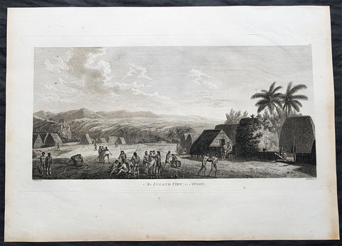
1784 Cook & Webber Large Antique Print of a Village on Kauai Island, Hawaii - Ist Edition
Antique Map
- Title : An Island View, in Atooi
- Size: 21in x 15in (535mm x 385mm)
- Condition: (A+) Fine Condition
- Date : 1784
- Ref #: 82065
Description:
This large original 1st edition copper-plate engraved antique print of a village the Hawaiian Island of Kauai (Atooi) visited by Captain Cook in 1778 was drawn by the official artist on Cooks crew, John Webber, and later published for the 1784 1st edition and official British Admiralty sanctioned account of Captain Cook’s third and final voyage along with that of Cooks successor Capt. James King......
A Voyage to the Pacific Ocean. Undertaken, by the Command of his Majesty, for making Discoveries in the Northern Hemisphere. To determine The Position and Extent of the West Side of North America; its Distance from Asia; and the Practicability of a Northern Passage to Europe. Performed under the direction of Captains Cook, Clerke, and Gore, In His Majesty\'s Ships the Resolution and Discovery. In the Years 1776, 1777, 1778, 1779, and 1780. In Three Volumes. Vol. I and II written by James Cook, F.R.S. Vol. III by Captain James King, LL.D. and F.R.S
Captain Cook arrived at the island of Atooi (Kauai) Hawaii on the 19th of January, 1778 and stayed until 23rd January. On the 21st January, Cook accompanied by John Webber, proceeded inland from their beach side anchorage to Waimea, on the south coast of Kauai. Their intention was to examine elevated objects visible from the ship. It proved to be a morai, or temple similar to ones they had seen in Tahiti and other South Pacific islands. This structure was nearly 20-feet high and covered in a thin, light-grey cloth, which likely had ceremonial significance. The temple rested on a platform and consisted of thousands of rough-edged lava rock piled in a tight, mortarless fashion. In the center is the spindly-legged oracle tower, where the priest (kahuna) might seek counsel or pray. Carved figures with tapa and leaf offerings are seen outside thatched huts topped with pili, the tall grass that grew throughout the lowlands. In his journal, Cook took particular note of several stone objects he had observed:
Cooks Journals - January 21, 1778
...........about the middle of the Morai, there were three of these places in line. We were told three chiefs had been buried there, and before them was another that was oblong. This they called Tanga (taboo or kapu in Hawaiian) and gave us clearly to understand that three human sacrifices had been buried there, that is, one at the burial of each chief.
General Definitions:
Paper thickness and quality: - Heavy and stable
Paper color : - off white
Age of map color: -
Colors used: -
General color appearance: -
Paper size: - 21in x 15in (535mm x 385mm)
Plate size: - 21in x 15in (535mm x 385mm)
Margins: - Min 1/2in (12mm)
Imperfections:
Margins: - Light soiling in margins
Plate area: - None
Verso: - None
Background:
Kauai is geologically the oldest of the main Hawaiian Islands. In 1778, Captain James Cook arrived at Waimea Bay, the first European known to have reached the Hawaiian islands. He named the archipelago after his patron the 6th Earl of Sandwich, George Montagu
Hawaii is the 50th and most recent state to have joined the United States of America, having received statehood on August 21, 1959. Hawaii is the only U.S. state located in Oceania and the only one composed entirely of islands. It is the northernmost island group in Polynesia, occupying most of an archipelago in the central Pacific Ocean. Hawaii is the only U.S. state located outside North America.
It is possible that Spanish explorers arrived in the Hawaiian Islands in the 16th century—200 years before Captain James Cook\\\\\\\'s first documented visit in 1778. Ruy López de Villalobos commanded a fleet of six ships that left Acapulco in 1542 bound for the Philippines with a Spanish sailor named Juan Gaetano aboard as pilot. Depending on the interpretation, Gaetanos reports describe an encounter with either Hawaii or the Marshall Islands. If de Villalobos crew spotted Hawaii, Gaetano would be considered the first European to see the islands. Some scholars have dismissed these claims due to a lack of credibility.
Spanish archives contain a chart that depicts islands at the same latitude as Hawaii but with a longitude ten degrees east of the islands. In this manuscript, the island of Maui is named La Desgraciada (The Unfortunate Island), and what appears to be Hawaii Island is named La Mesa (The Table). Islands resembling Kahoolawe, Lanai, and Molokai are named Los Monjes (The Monks). For two-and-a-half centuries, Spanish galleons crossed the Pacific from Mexico along a route that passed south of Hawaii on their way to Manila. The exact route was kept secret to protect the Spanish trade monopoly against competing powers.
The 1778 arrival of British explorer James Cook was the first documented contact by a European explorer with Hawaii. Cook named the archipelago as the Sandwich Islands in honor of his sponsor John Montagu, 4th Earl of Sandwich. Cook published the islands location and rendered the native name as Owyhee. This spelling lives on in Owyhee County, Idaho. It was named after three native Hawaiian members of a trapping party who went missing in that area. The Owyhee Mountains were also named for them
Cook visited the Hawaiian Islands twice. As he prepared for departure after his second visit in 1779, a quarrel ensued as Cook took temple idols and fencing as firewood and a minor chief and his men took a ship\\\\\\\'s boat. Cook abducted the King of Hawaii Island, Kalani ōpu u, and held him for ransom aboard his ship in order to gain return of Cook\\\\\\\'s boat. This tactic had worked in Tahiti and other islands. Instead, Kalani ōpu u s supporters fought back, killing Cook and four marines as Cooks party retreated along the beach to their ship. They departed without the ships boat.
Captain James King FRS 1750 – 1784 was an officer of the Royal Navy. He served under James Cook on his last voyage around the world, specialising in taking important astronomical readings using a sextant. After Cook died he helped lead the ships on the remainder of their course, also completing Cooks account of the voyage. He continued his career in the Navy, reaching the rank of post-captain, commanding several ships and serving in the American War of Independence.
King joined HMS Resolution as second lieutenant, sharing the duties of astronomer with Cook, taking astronomical observations on board by sextant and with Larcum Kendals timekeeper K1, to establish the Resolutions position at sea and on shore by sextant or by astronomical quadrant to establish the geographical position of salient points during the course of Cooks surveys. Thus Kings geographical positions were an important contribution to the accuracy of the various surveys carried out during the voyage and his use of the early chronometers helped prove their use at sea for calculation of Longitude. .
Following the death of Cook, King remained in the Resolution but on the death of Charles Clerke, Cooks successor, King was appointed to command HMS Discovery, the Resolutions consort, remaining in her for the rest of the voyage. After his return to England King was very much involved in the publication of the official account of Cooks third voyage, writing the third volume at Woodstock, near Oxford, where his brother Thomas was rector of St Mary Magdalene. But shortly after his return King was promoted Post-captain and appointed commander of HMS Crocodile in the English Channel.
John Webber RA 1751 – 1793 was an English artist who accompanied Captain Cook on his third Pacific expedition. He is best known for his images of Australasia, Hawaii and Alaska.
Webber was born in London, educated in Bern and studied painting at Paris.His father was Abraham Wäber, a Swiss sculptor who had moved to London, and changed his name to Webber before marrying a Mrs Mary Quant in 1744.
Webber served as official artist on James Cooks third voyage of discovery around the Pacific (1776–80) aboard HMS Resolution. At Adventure Bay in January 1777 he did drawings of A Man of Van Diemens Land and A Woman of Van Diemens Land. He also did many drawings of scenes in New Zealand and the South Sea islands. On this voyage, during which Cook lost his life in a fight in Hawaii, Webber became the first European artist to make contact with Hawaii, then called the Sandwich Islands. He made numerous watercolor landscapes of the islands of Kauai and Hawaii, and also portrayed many of the Hawaiian people.
In April 1778, Captain Cooks ships Resolution and Discovery anchored at Ship Cove, now known as Nootka Sound, Vancouver Island, Canada to refit. The crew took observations and recorded encounters with the local people. Webber made watercolour landscapes including Resolution and Discovery in Ship Cove, 1778. His drawings and paintings were engraved for British Admiraltys account of the expedition, which was published in 1784.
Back in England in 1780 Webber exhibited around 50 works at Royal Academy exhibitions between 1784 and 1792, and was elected an associate of the Royal Academy in 1785 and R.A. in 1791. Most of his work were landscapes. Sometimes figures were included as in A Party from H.M.S. Resolution shooting sea horses, which was shown at the academy in 1784, and his The Death of Captain Cook became well known through an engraving of it. Another version of this picture is in the William Dixson gallery at Sydney
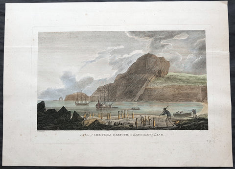
1784 Cook 1st edition Antique Print HMS Resolution & Discovery Xmas Bay, Kerguelen Isle 1776
Antique Map
- Title : A view of Christmas Harbour in Kerguelens Land
- Ref : 31726
- Size: 20in x 14 1/2in (510mm x 370mm)
- Date : 1784
- Condition: (A) Very Good Condition
Description:
This fine original copper-plate engraved antique print of HMS Resolution & Discovery anchored in Christmas Bay, on Kerguelen Islands on Christmas day in 1776, was engraved by James Newton (1748-1804) after a painting by Cooks onboard artist John Webber, during Cooks 3rd & last voyage of Discovery was published in the 1784 1st English edition of Capt. James Cook & Capt. James King A Voyage to the Pacific Ocean. Undertaken, by the Command of his Majesty, for making Discoveries in the Northern Hemisphere. To determine The Position and Extent of the West Side of North America; its Distance from Asia; and the Practicability of a Northen Passage to Europe. Performed under the direction of Captains Cook, Clerke, and Gore, In His Majestys Ships the Resolution and Discovery. In the Years 1776, 1777, 1778, 1779, and 1780. London 1784.
Cook wrote..........I found the shore in a manner covered with Penguins and other birds and Seals…so fearless that we killed as ma(n)y as we chose for the sake of their fat or blubber to make Oil for our lamps and other uses… Here I displayd the British flag and named the harbour Christmas harbour as we entered it on that Festival..... (Journals III, i, 29-32)
General Definitions:
Paper thickness and quality: - Heavy and stable
Paper color : - off white
Age of map color: - Early
Colors used: - Yellow, green, blue, pink
General color appearance: - Authentic
Paper size: - 20in x 14 1/2in (510mm x 370mm)
Plate size: - 16in x 10 1/2in (410mm x 270mm)
Margins: - Min 1in (25mm)
Imperfections:
Margins: - None
Plate area: - Single heavy vertical crease along top of image, pressed out
Verso: - None
Background:
The Kerguelen Islands, sometimes called the Desolation Islands, are located in the southern Indian Ocean and were discovered by the French navigator Yves de Kerguelen-Trémarec in 1772. On Christmas Day, 1776 Cook’s ships Resolution and Discovery anchored in Oiseau Bay, which he named Christmas Harbour. Cook\'s men discovered a bottle containing a message in Latin left by Kerguelen\'s men. Cook wrote in his log: “I could have very properly called the island Desolation Island to signalise its sterility, but in order not to deprive M. de Kerguelen of the glory of having discovered it, I have called it Kerguelen Land.”
The Kerguelen Islands or the Kerguelen Archipelago are located in the southern Indian Ocean. The main island, Grande Terre, is 6,675 km² and it is surrounded by another 300 smaller islands and islets, forming an archipelago of 7,215 km². The climate is cold and very windy and the seas are usually rough. The islands are part of a submarine large igneous province called the Kerguelen Plateau.
Captain James King FRS 1750 – 1784 was an officer of the Royal Navy. He served under James Cook on his last voyage around the world, specialising in taking important astronomical readings using a sextant. After Cook died he helped lead the ships on the remainder of their course, also completing Cooks account of the voyage. He continued his career in the Navy, reaching the rank of post-captain, commanding several ships and serving in the American War of Independence.
King joined HMS Resolution as second lieutenant, sharing the duties of astronomer with Cook, taking astronomical observations on board by sextant and with Larcum Kendals timekeeper K1, to establish the Resolutions position at sea and on shore by sextant or by astronomical quadrant to establish the geographical position of salient points during the course of Cooks surveys. Thus Kings geographical positions were an important contribution to the accuracy of the various surveys carried out during the voyage and his use of the early chronometers helped prove their use at sea for calculation of Longitude. .
Following the death of Cook, King remained in the Resolution but on the death of Charles Clerke, Cooks successor, King was appointed to command HMS Discovery, the Resolutions consort, remaining in her for the rest of the voyage. After his return to England King was very much involved in the publication of the official account of Cooks third voyage, writing the third volume at Woodstock, near Oxford, where his brother Thomas was rector of St Mary Magdalene. But shortly after his return King was promoted Post-captain and appointed commander of HMS Crocodile in the English Channel.
John Webber RA 1751 – 1793 was an English artist who accompanied Captain Cook on his third Pacific expedition. He is best known for his images of Australasia, Hawaii and Alaska.
Webber was born in London, educated in Bern and studied painting at Paris.His father was Abraham Wäber, a Swiss sculptor who had moved to London, and changed his name to Webber before marrying a Mrs Mary Quant in 1744.
Webber served as official artist on James Cook\\\'s third voyage of discovery around the Pacific (1776–80) aboard HMS Resolution. At Adventure Bay in January 1777 he did drawings of A Man of Van Diemens Land and A Woman of Van Diemens Land. He also did many drawings of scenes in New Zealand and the South Sea islands. On this voyage, during which Cook lost his life in a fight in Hawaii, Webber became the first European artist to make contact with Hawaii, then called the Sandwich Islands. He made numerous watercolor landscapes of the islands of Kauai and Hawaii, and also portrayed many of the Hawaiian people.
In April 1778, Captain Cooks ships Resolution and Discovery anchored at Ship Cove, now known as Nootka Sound, Vancouver Island, Canada to refit. The crew took observations and recorded encounters with the local people. Webber made watercolour landscapes including Resolution and Discovery in Ship Cove, 1778. His drawings and paintings were engraved for British Admiraltys account of the expedition, which was published in 1784.
Back in England in 1780 Webber exhibited around 50 works at Royal Academy exhibitions between 1784 and 1792, and was elected an associate of the Royal Academy in 1785 and R.A. in 1791. Most of his work were landscapes. Sometimes figures were included as in A Party from H.M.S. Resolution shooting sea horses\\\", which was shown at the academy in 1784, and his The Death of Captain Cook became well known through an engraving of it. Another version of this picture is in the William Dixson gallery at Sydney

1784 Du Bocage & Barthelemy Antique Map of Plato's Academy in Athens, Greece
- Title : L Helles-Pont...1782
- Size: 15in x 10in (380mm x 255mm)
- Ref #: 16462
- Date : 1784
- Condition: (A+) Fine Condition
Description:
This original copper-plate engraved map by Jean Denis Barbie du Bocage was engraved in 1784 - dated in the title - and was published in the 1787 edition of Jean-Jacques Barthelemy famous Voyage du jeune Anarcharsis en Grece or Travels of Anacharsis the younger in Greecein 4 volumes.
General Definitions:
Paper thickness and quality: - Heavy and stable
Paper color : - off white
Age of map color: -
Colors used: -
General color appearance: -
Paper size: - 15in x 10in (380mm x 255mm)
Plate size: - 8 1/2in x 7 1/2in (215mm x 185mm)
Margins: - Min 1in (25mm)
Imperfections:
Margins: - None
Plate area: - Folds as issued
Verso: - None
Background:
Jean-Jacques Barthelemy 1716 – 1795 was a French writer and numismatist.
Barthelemy was the author of a number of learned works on antiquarian subjects, but the great work on which his fame rests is Travels of Anacharsis the younger in Greece (French: Voyage du jeune Anarcharsis en Grece, 4 vols., 1787). He had begun it in 1757 and had been working on it for thirty years. The hero, a young Scythian descended from the famous philosopher Anacharsis, is supposed to repair to Greece for instruction in his early youth, and after making the tour of her republics, colonies and islands, to return to his native country and write this book in his old age, after the Macedonian hero had overturned the Persian empire. In the manner of modern travellers, he gives an account of the customs, government, and antiquities of the country he is supposed to have visited. A copious introduction supplies whatever may be wanting in respect to historical details, while various dissertations on the music of the Greeks, on the literature of the Athenians, and on the economy, pursuits, ruling passions, manners, and customs of the surrounding states supply ample information on the subjects of which they treat.
Modern scholarship has superseded most of the details in the Voyage, but the author himself did not imagine his book to be a register of accurately ascertained facts. Rather, he intended to afford to his countrymen, in an interesting form, some knowledge of Greek civilisation. The Charicles, or Illustrations of the Private Life of the Ancient Greeks of Wilhelm Adolf Becker is an attempt in a similar direction
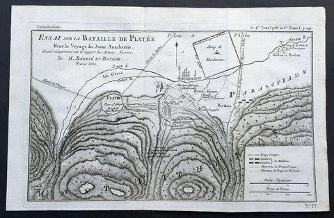
1784 Du Bocage Large Antique Map of The Battle of Platea City of Plataea Boeotia
- Title : Essai sur la Bataille de Platee...1784
- Ref #: 16469
- Size: 15 3/4in x 9 1/2in (400mm x 240mm)
- Date : 1784
- Condition: (A+) Fine Condition
Description:
This fine large original antique map or plan of the Battle of Platea, Greece near the city of Plataea in Boeotia, was engraved in 1784 - dated - and was published by Jean Denis Barbie du Bocage in his Voyage Anacharsis (The Travels of Anacharsis the Younger in Greece) publishedbetween 1781 - 1788.
Voyage Anacharsis is an illustrative account of the travels of Anacharsis the Younger in Greece, during the middle of the fourth century before the Christian era.
General Description:
Paper thickness and quality: - Heavy & stable
Paper color: - White
Age of map color: -
Colors used: -
General color appearance: -
Paper size: - 15 3/4in x 9 1/2in (400mm x 240mm)
Plate size: - 14 1/2in x 9in (360mm x 230mm)
Margins: - Min 1/2in (12mm)
Imperfections:
Margins: - None
Plate area: - Folds as issued
Verso: - None

1784 Du Bocage Large Antique Map of The Bosphorus Straits, Turkey
- Title : Plan Du Bosphore de Thrace...1784
- Ref #: 16466
- Size: 15 3/4in x 9 1/2in (400mm x 240mm)
- Date : 1784
- Condition: (A+) Fine Condition
Description:
This fine large original antique map Bosphorus Straits, Turkey was engraved in 1784 - dated - and was published by Jean Denis Barbie du Bocage in his Voyage Anacharsis (The Travels of Anacharsis the Younger in Greece) publishedbetween 1781 - 1788.
Voyage Anacharsis is an illustrative account of the travels of Anacharsis the Younger in Greece, during the middle of the fourth century before the Christian era.
General Description:
Paper thickness and quality: - Heavy & stable
Paper color: - White
Age of map color: -
Colors used: -
General color appearance: -
Paper size: - 15 3/4in x 9 1/2in (400mm x 240mm)
Plate size: - 12 1/2in x 8 1/2in (320mm x 220mm)
Margins: - Min 1/2in (12mm)
Imperfections:
Margins: - None
Plate area: - Folds as issued
Verso: - None