Products
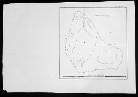
1774 Hawkesworth Antique Map of Wallis (Uvea) & Funtuna Islands Capt Wallis 1767
- Title : Isles de Wallis
- Size: 14in x 10in (360mm x 255mm)
- Ref #: 21598
- Date : 1774
- Condition: (A+) Fine Condition
Description:
This fine original copper-plate engraved antique map of the Islands of Wallis (Uvea) and Futuna, situated in the South Pacific between Tuvalu to the northwest, Fiji to the southwest, Tonga to the southeast, Samoa to the east. Futuna was first mapped by Willem Schouten and Jacob Le Maire during their famous circumnavigation of the globe in 1616 and Wallis (Uvea) being mapped by Captain Samuel Wallis, who saw it while sailing the HMS Dolphin on 16 August 1767, was published in the 1774 French edition of John Hawkesworths An Account of the Voyages Undertaken by the Order of His Present Majesty for Making Discoveries in the Southern Hemisphere and Successively Performed by Commodore Byron, Captain Wallis, Captain Carteret, and Captain Cook, in the Dolphin, the Swallow, and the Endeavor, Drawn Up from the Journals Which Were Kept by the Several Commanders, and from the Papers of Joseph Banks, Esq. Paris 1774
General Definitions:
Paper thickness and quality: - Heavy and stable
Paper color : - off white
Age of map color: -
Colors used: -
General color appearance: -
Paper size: - 10in x 9in (255mm x 230mm)
Plate size: - 9in x 8in (230mm x 205mm)
Margins: - Min 1/2in (12mm)
Imperfections:
Margins: - None
Plate area: - None
Verso: - None
Background:
Wallis or Uvea, is a Polynesian island in the Pacific Ocean belonging to the French overseas collectivity of Wallis and Futuna. It lies north of Tonga, northeast of Fiji, east-northeast of the Hoorn islands, east of Fijis Rotuma, southeast of Tuvalu, southwest of Tokelau and west of Samoa. Its area is almost 100 km2 with almost 11,000 people. Its capital is Matā utu.
The island was renamed Wallis after a Cornish navigator, Captain Samuel Wallis, who saw it while sailing the HMS Dolphin on 16 August 1767, following his discovery of Tahiti.
Futuna was first put on the European maps by Willem Schouten and Jacob Le Maire during their famous circumnavigation of the globe in 1616. They named the islands Hoornse Eylanden after the Dutch town of Hoorn where they hailed from. This was later translated into French as Isles de Horne. The French were the first Europeans to settle in the territory with the arrival of French missionaries in 1837
Samuel Wallis 1728 – 1795
was a British naval officer and explorer of the Pacific Ocean.
Wallis was born near Camelford, Cornwall. He served under John Byron, and in 1766 was promoted to captain and was given the command of HMS Dolphin (1751) as part of an expedition led by Philip Carteret in the Swallow with an assignment to circumnavigate the globe. The two ships were parted by a storm shortly after sailing through the Strait of Magellan, Wallis continuing to Tahiti, which he named King George the Thirds Island in honour of the King (June 1767). Wallis himself was ill and remained in his cabin: lieutenant Tobias Furneaux was the first to set foot, hoisting a pennant and turning a turf, taking possession in the name of His Majesty. Dolphin stayed in Matavai Bay in Tahiti for over a month. Wallis went on to name or rename five more islands in the Society Islands and six atolls in the Tuamotu Islands, as well as confirming the locations of Rongerik and Rongelap in the Marshall Islands. He renamed the Polynesian island of Uvea as Wallis after himself, before reaching Tinian in the Mariana Islands. He continued to Batavia, where many of the crew died from dysentery, then via the Cape of Good Hope to England, arriving in May 1768. He was able to pass on useful information to James Cook who was due to depart shortly for the Pacific, and some of the crew from the Dolphin sailed with Cook. In 1780 Wallis was appointed Commissioner of the Admiralty.
Capt. Philip Carteret (1733-1796)
was a British naval officer and explorer who participated in two of the Royal Navy\\\\\\\'s circumnavigation expeditions in 1764-66 and 1766-69.
Carteret entered the Navy in 1747, serving aboard the Salisbury, and then under Captain John Byron from 1751 to 1755. Between 1757 and 1758 he was in the Guernsey on the Mediterranean Station. As a lieutenant in the Dolphin he accompanied Byron during his voyage of circumnavigation, from June 1764 to May 1766.
In 1766 he was made a commander and given the command of the Swallow to circumnavigate the world, as consort to the Dolphin under the command of Samuel Wallis. The two ships were parted shortly after sailing through the Strait of Magellan, Carteret discovering Pitcairn Island and the Carteret Islands, which were subsequently named after him. In 1767, he also discovered a new archipelago inside Saint George\\\\\\\'s Channel between New Ireland and New Britain Islands (Papua New Guinea) and named it Duke of York Islands, as well as rediscovered the Solomon Islands first sighted by the Mendana in 1568, and the Juan Fernandez Islands first discovered by Juan Fernandez in 1574. He arrived back in England, at Spithead, on 20 March 1769.
He was promoted to post captain in 1771.
1774 Hawkesworth Antique Print Capt Wallis attacked in Matavia Bay, Tahiti, 1767
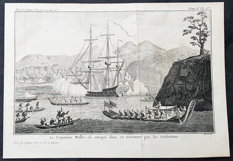
- Title : Le Capitaine Wallis est attaque dans L Dauphin par les Otahitiens (Captain Wallis attacked in The Dolphin by the Tahitians)
- Size: 14in x 10in (365mm x 255mm)
- Ref #: 25928
- Date : 1774
- Condition: (A+) Fine Condition
Description:
This fine original copper-plate engraved antique print of Captain Samuel Wallis in his ship the HMS Dolphin being attacked by the Tahitians in Matavai Bay - with one tree hill to the right - in 1767 was engraved by Robert Benard and was published in the 1774 French edition of John Hawkesworths An Account of the Voyages Undertaken by the Order of His Present Majesty for Making Discoveries in the Southern Hemisphere and Successively Performed by Commodore Byron, Captain Wallis, Captain Carteret, and Captain Cook, in the Dolphin, the Swallow, and the Endeavor, Drawn Up from the Journals Which Were Kept by the Several Commanders, and from the Papers of Joseph Banks, Esq. Paris 1774
From the log of Samuel Wallis, Captain of The Dolphin 1767.......
At two in the morning, it being very clear, we made sail again; at day-break we saw the land, at about five leagues distance, and steered directly for it; but at eight o’clock, when we were close under it, the fog obliged us again to lie to, and when it cleared away, we were much surprised to find ourselves surrounded by some hundreds of canoes…. When they came within pistol shot of the ship, they lay by, gazing at us with great astonishment, and by turns conferring with each other. In the mean time we showed them trinkets of various kinds, and invited them on board. Soon after, they drew together, and held a kind of council, to determine what should be done: then they all paddled around the ship, making signs of friendship, and one of them holding up a branch of the plantain tree, made a speech that lasted near a quarter of an hour, and then threw it into the sea. Soon after, as we continued to make signs of invitation, a fine, stout, lively young man ventured on board: he came up by the mizzen chains, and jumped out of the shrouds on top of the awning. We made signs to him to come down upon the quarter-deck, and handed up some trinkets to him: he looked pleased, but would accept of nothing till some of the Indians came alongside, and after much talk, threw a few branches of plantain tree on board the ship. He then accepted our presents, and several others very soon came on board.
As we had no anchorage here, we stood along the shore, sending the boats at the same time to sound at a less distance…. About three o’clock in the afternoon, we brought to, abreast of a large bay, where there was an appearance of anchorage. The boats were immediately sent to sound it, and while they were thus employed, I observed a great number of canoes gather round them. I suspected that the Indians had a design to attack them, and as I was very desirous to prevent mischief, I made the signal for the boats to come aboard, and at the same time, to intimidate the Indians, I fired a nine-pounder over their heads. As soon as the cutter began to stand towards the ship, the Indians in their canoes, though they had been startled by the thunder of our nine-pounder, endeavoured to cut her off. The boat, however, sailing faster than the canoes could paddle, soon got clear of those that were about her; but some others, that were full of men, waylaid her in her course, and threw several stones into her, which wounded some of the people. Upon this, the officer on board fired a musquet, loaded with buck-shot, at the man who threw the first stone, and wounded him in the shoulder. The rest of the people in the canoes, as soon as they perceived their companion wounded, leapt in to the sea, and the other canoes paddled away, in great terror and confusion.
General Definitions:
Paper thickness and quality: - Heavy and stable
Paper color : - off white
Age of map color: -
Colors used: -
General color appearance: -
Paper size: - 14in x 10in (365mm x 255mm)
Plate size: - 14in x 10in (365mm x 255mm)
Margins: - Min 1/2in (12mm)
Imperfections:
Margins: - None
Plate area: - Folds as issued
Verso: - None
Background:
Samuel Wallis 1728 – 1795
was a British naval officer and explorer of the Pacific Ocean.
Wallis was born near Camelford, Cornwall. He served under John Byron, and in 1766 was promoted to captain and was given the command of HMS Dolphin (1751) as part of an expedition led by Philip Carteret in the Swallow with an assignment to circumnavigate the globe. The two ships were parted by a storm shortly after sailing through the Strait of Magellan, Wallis continuing to Tahiti, which he named King George the Thirds Island in honour of the King (June 1767). Wallis himself was ill and remained in his cabin: lieutenant Tobias Furneaux was the first to set foot, hoisting a pennant and turning a turf, taking possession in the name of His Majesty. Dolphin stayed in Matavai Bay in Tahiti for over a month. Wallis went on to name or rename five more islands in the Society Islands and six atolls in the Tuamotu Islands, as well as confirming the locations of Rongerik and Rongelap in the Marshall Islands. He renamed the Polynesian island of Uvea as Wallis after himself, before reaching Tinian in the Mariana Islands. He continued to Batavia, where many of the crew died from dysentery, then via the Cape of Good Hope to England, arriving in May 1768. He was able to pass on useful information to James Cook who was due to depart shortly for the Pacific, and some of the crew from the Dolphin sailed with Cook. In 1780 Wallis was appointed Commissioner of the Admiralty.
Tahiti previously also known as Otaheite is the largest island in the Windward group of French Polynesia. The island is located in the archipelago of the Society Islands in the central Southern Pacific Ocean.
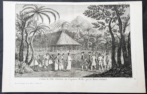
The first European to have visited Tahiti according to existing records was lieutenant Samuel Wallis, who was circumnavigating the globe in HMS Dolphin, sighting the island on 18 June 1767, and eventually harboring in Matavai Bay. This bay was situated on the territory of the chiefdom of Pare-Arue, governed by Tu (Tu-nui-e-a a-i-te-Atua) and his regent Tutaha, and the chiefdom of Ha apape, governed by Amo and his wife Oberea (Purea). Wallis named the island King Georges Island. The first contacts were difficult, since on the 24 and 26 June 1767, Tahitian warriors in canoes showed aggression towards the British, hurling stones from their slings. In retaliation, the British sailors opened fire on the warriors in the canoes and on the hills. In reaction to this powerful counter-attack, the Tahitians laid down peace offerings for the British. Following this episode, Samuel Wallis was able to establish cordial relations with the female chieftain “Oberea “ (Purea) and remained on the island until 27 July 1767.
In July 1768, Captain James Cook was commissioned by the Royal Society and on orders from the Lords Commissioners of the Admiralty to observe the transit of Venus across the sun, a phenomenon that would be visible from Tahiti on 3 June 1769. He arrived in Tahitis Matavai Bay, commanding the HMS Endeavour on 12 April 1769. On 14 April, Cook met with Tutaha and Tepau. On 15 April, Cook picked the site for a fortified camp at Point Venus along with Banks, Parkinson, Daniel Solander, to protect Charles Greens observatory. The length of stay enabled them to undertake for the first time real ethnographic and scientific observations of the island. Assisted by the botanist Joseph Banks, and by the artist Sydney Parkinson, Cook gathered valuable information on the fauna and flora, as well as the native society, language and customs, including the proper name of the island, Otaheite. On 28 April, Cook met Purea and Tupaia, and Tupaia befriended Banks following the transit. On 21 June, Amo visited Cook, and then on 25 June, Pohuetea visited, signifying another chief seeking to ally himself with the British.
Cook and Banks circumnavigated the island from 26 June to 1 July. On the exploration, they met Ahio, chief of Ha apaiano o or Papenoo, Rita, chief of Hitia a, Pahairro, chief of Pueu, Vehiatua, chief of Tautra, Matahiapo, chief of Teahupo o, Tutea, chief of Vaira o, and Moe, chief of Afa Ahiti. In Papara, guided by Tupaia, they investigated the ruins of Mahaiatea marae, an impressive structure containing a stone pyramid or ahu, measuring 44 feet high, 267 feet long and 87 feet wide. Cook and the Endeavour departed Tahiti on 13 July 1769, taking Raiatean navigator Tupaia along for his geographic knowledge of the islands.
Cook returned to Tahiti between 15 August and 1 September 1773, greeted by the chiefs Tai and Puhi, besides the youg ari i Vehiatua II and his stepfather Ti itorea. Cook anchored in Vaitepiha Bay before returning to Point Venus where he met Tu, the paramount chief. Cook picked up two passengers from Tahiti during this trip, Porea and Mai, with Hitihiti later replacing Porea when Cook stopped at Raiatea. Cook took Hitihiti to Tahiti on 22 April, during his return leg. Then, Cook departed Tahiti on 14 May 1774.
During his final visit, Cook returned Mai to Tahiti on 12 Aug. 1777, after Mais long visit in England. Cook also brought two Maori from Queen Charlotte Sound, Te Weherua and Koa. Cook first harbored in Vaitepiha Bay, where he visited Vehiatua II s funeral bier and the prefabricated Spanish mission house. Cook also met Vehiatua III, and inscribed on the back of the Spanish cross, Georgius tertius Rex Annis 1767, 69, 73, 74 & 77, as a counterpoint to Christus Vincit Carolus III imperat 1774 on the front. On 23 Aug., Cook sailed for Matavai Bay, where he met Tu, his father Teu, his mother Tetupaia, his brothers Ari ipaea and Vaetua, and his sisters Ari ipaea-vahine, Tetua-te-ahamai, and Auo. Cook also observed a human sacrifice, taata tapu, at the Utu-ai-mahurau marae, and 49 skulls from previous victims.
On 29 Sept. 1777, Cook sailed for Papetoai Bay on Moorea. Cook met Mahine in an act of friendship on 3 Oct., though he was an enemy of Tu. When a goat kid was stolen on 6 Oct., Cook in a rampage, ordered the burning of houses and canoes until it was returned. Cook sailed for Huahine on 11 Oct., Raiatea on 2 Nov., and Borabora on 7 Dec.
On 26 October 1788, HMS Bounty, under the command of Captain William Bligh, landed in Tahiti with the mission of carrying Tahitian breadfruit trees (Tahitian: uru) to the Caribbean. Sir Joseph Banks, the botanist from James Cooks first expedition, had concluded that this plant would be ideal to feed the African slaves working in the Caribbean plantations at very little cost. The crew remained in Tahiti for about five months, the time needed to transplant the seedlings of the trees. Three weeks after leaving Tahiti, on 28 April 1789, the crew mutinied on the initiative of Fletcher Christian. The mutineers seized the ship and set the captain and most of those members of the crew who remained loyal to him adrift in a ships boat. A group of mutineers then went back to settle in Tahiti.
Although various explorers had refused to get involved in tribal conflicts, the mutineers from the Bounty offered their services as mercenaries and furnished arms to the family which became the Pōmare Dynasty. The chief Tū knew how to use their presence in the harbours favoured by sailors to his advantage. As a result of his alliance with the mutineers, he succeeded in considerably increasing his supremacy over the island of Tahiti.
Robert Bénard 1734 – 1777 was an 18th-century French engraver.
Specialized in the technique of engraving, Robert Ménard is mainly famous for having supplied a significant amount of plates (at least 1,800) to the Encyclopédie by Diderot & d\'Alembert from 1751.
Later, publisher Charles-Joseph Panckoucke reused many of his productions to illustrate the works of his catalog.
1774 Hawkesworth Antique Print Queen Purea Surrender to Capt Wallis Tahiti, 1767
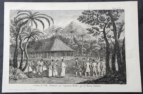
- Title : Cession de lisle D otahiti au Capitaine Wallis par la Reine Oberea (Surrender of the Island of Taahiti to Capt Wallis by Queen Obera)
- Size: 14in x 10in (365mm x 255mm)
- Ref #: 25925
- Date : 1774
- Condition: (A) Very Good Condition
Description:
This fine original copper-plate engraved antique print of Captain Samuel Wallis - the first European to visit Tahiti in 1767 - accepting surrender from Queen Purea (Oberea) of Tahiti, after the battle in Matavia Bay in 1767, was engraved by Robert Benard and was published in the 1774 French edition of John Hawkesworths An Account of the Voyages Undertaken by the Order of His Present Majesty for Making Discoveries in the Southern Hemisphere and Successively Performed by Commodore Byron, Captain Wallis, Captain Carteret, and Captain Cook, in the Dolphin, the Swallow, and the Endeavor, Drawn Up from the Journals Which Were Kept by the Several Commanders, and from the Papers of Joseph Banks, Esq. Paris 1774
From the log of Samuel Wallis, Captain of The Dolphin 1767.......
At two in the morning, it being very clear, we made sail again; at day-break we saw the land, at about five leagues distance, and steered directly for it; but at eight o’clock, when we were close under it, the fog obliged us again to lie to, and when it cleared away, we were much surprised to find ourselves surrounded by some hundreds of canoes…. When they came within pistol shot of the ship, they lay by, gazing at us with great astonishment, and by turns conferring with each other. In the mean time we showed them trinkets of various kinds, and invited them on board. Soon after, they drew together, and held a kind of council, to determine what should be done: then they all paddled around the ship, making signs of friendship, and one of them holding up a branch of the plantain tree, made a speech that lasted near a quarter of an hour, and then threw it into the sea. Soon after, as we continued to make signs of invitation, a fine, stout, lively young man ventured on board: he came up by the mizzen chains, and jumped out of the shrouds on top of the awning. We made signs to him to come down upon the quarter-deck, and handed up some trinkets to him: he looked pleased, but would accept of nothing till some of the Indians came alongside, and after much talk, threw a few branches of plantain tree on board the ship. He then accepted our presents, and several others very soon came on board.
As we had no anchorage here, we stood along the shore, sending the boats at the same time to sound at a less distance…. About three o’clock in the afternoon, we brought to, abreast of a large bay, where there was an appearance of anchorage. The boats were immediately sent to sound it, and while they were thus employed, I observed a great number of canoes gather round them. I suspected that the Indians had a design to attack them, and as I was very desirous to prevent mischief, I made the signal for the boats to come aboard, and at the same time, to intimidate the Indians, I fired a nine-pounder over their heads. As soon as the cutter began to stand towards the ship, the Indians in their canoes, though they had been startled by the thunder of our nine-pounder, endeavoured to cut her off. The boat, however, sailing faster than the canoes could paddle, soon got clear of those that were about her; but some others, that were full of men, waylaid her in her course, and threw several stones into her, which wounded some of the people. Upon this, the officer on board fired a musquet, loaded with buck-shot, at the man who threw the first stone, and wounded him in the shoulder. The rest of the people in the canoes, as soon as they perceived their companion wounded, leapt in to the sea, and the other canoes paddled away, in great terror and confusion.
General Definitions:
Paper thickness and quality: - Heavy and stable
Paper color : - off white
Age of map color: -
Colors used: -
General color appearance: -
Paper size: - 14in x 10in (365mm x 255mm)
Plate size: - 14in x 10in (365mm x 255mm)
Margins: - Min 1/2in (12mm)
Imperfections:
Margins: - None
Plate area: - Folds as issued
Verso: - None
Background:
Samuel Wallis 1728 – 1795
was a British naval officer and explorer of the Pacific Ocean.
Wallis was born near Camelford, Cornwall. He served under John Byron, and in 1766 was promoted to captain and was given the command of HMS Dolphin (1751) as part of an expedition led by Philip Carteret in the Swallow with an assignment to circumnavigate the globe. The two ships were parted by a storm shortly after sailing through the Strait of Magellan, Wallis continuing to Tahiti, which he named King George the Thirds Island in honour of the King (June 1767). Wallis himself was ill and remained in his cabin: lieutenant Tobias Furneaux was the first to set foot, hoisting a pennant and turning a turf, taking possession in the name of His Majesty. Dolphin stayed in Matavai Bay in Tahiti for over a month. Wallis went on to name or rename five more islands in the Society Islands and six atolls in the Tuamotu Islands, as well as confirming the locations of Rongerik and Rongelap in the Marshall Islands. He renamed the Polynesian island of Uvea as Wallis after himself, before reaching Tinian in the Mariana Islands. He continued to Batavia, where many of the crew died from dysentery, then via the Cape of Good Hope to England, arriving in May 1768. He was able to pass on useful information to James Cook who was due to depart shortly for the Pacific, and some of the crew from the Dolphin sailed with Cook. In 1780 Wallis was appointed Commissioner of the Admiralty.
Tahiti previously also known as Otaheite is the largest island in the Windward group of French Polynesia. The island is located in the archipelago of the Society Islands in the central Southern Pacific Ocean.
The first European to have visited Tahiti according to existing records was lieutenant Samuel Wallis, who was circumnavigating the globe in HMS Dolphin, sighting the island on 18 June 1767, and eventually harboring in Matavai Bay. This bay was situated on the territory of the chiefdom of Pare-Arue, governed by Tu (Tu-nui-e-a a-i-te-Atua) and his regent Tutaha, and the chiefdom of Ha apape, governed by Amo and his wife Oberea (Purea). Wallis named the island King Georges Island. The first contacts were difficult, since on the 24 and 26 June 1767, Tahitian warriors in canoes showed aggression towards the British, hurling stones from their slings. In retaliation, the British sailors opened fire on the warriors in the canoes and on the hills. In reaction to this powerful counter-attack, the Tahitians laid down peace offerings for the British. Following this episode, Samuel Wallis was able to establish cordial relations with the female chieftain “Oberea “ (Purea) and remained on the island until 27 July 1767.
In July 1768, Captain James Cook was commissioned by the Royal Society and on orders from the Lords Commissioners of the Admiralty to observe the transit of Venus across the sun, a phenomenon that would be visible from Tahiti on 3 June 1769. He arrived in Tahitis Matavai Bay, commanding the HMS Endeavour on 12 April 1769. On 14 April, Cook met with Tutaha and Tepau. On 15 April, Cook picked the site for a fortified camp at Point Venus along with Banks, Parkinson, Daniel Solander, to protect Charles Greens observatory. The length of stay enabled them to undertake for the first time real ethnographic and scientific observations of the island. Assisted by the botanist Joseph Banks, and by the artist Sydney Parkinson, Cook gathered valuable information on the fauna and flora, as well as the native society, language and customs, including the proper name of the island, Otaheite. On 28 April, Cook met Purea and Tupaia, and Tupaia befriended Banks following the transit. On 21 June, Amo visited Cook, and then on 25 June, Pohuetea visited, signifying another chief seeking to ally himself with the British.
Cook and Banks circumnavigated the island from 26 June to 1 July. On the exploration, they met Ahio, chief of Ha apaiano o or Papenoo, Rita, chief of Hitia a, Pahairro, chief of Pueu, Vehiatua, chief of Tautra, Matahiapo, chief of Teahupo o, Tutea, chief of Vaira o, and Moe, chief of Afa Ahiti. In Papara, guided by Tupaia, they investigated the ruins of Mahaiatea marae, an impressive structure containing a stone pyramid or ahu, measuring 44 feet high, 267 feet long and 87 feet wide. Cook and the Endeavour departed Tahiti on 13 July 1769, taking Raiatean navigator Tupaia along for his geographic knowledge of the islands.
Cook returned to Tahiti between 15 August and 1 September 1773, greeted by the chiefs Tai and Puhi, besides the youg ari i Vehiatua II and his stepfather Ti itorea. Cook anchored in Vaitepiha Bay before returning to Point Venus where he met Tu, the paramount chief. Cook picked up two passengers from Tahiti during this trip, Porea and Mai, with Hitihiti later replacing Porea when Cook stopped at Raiatea. Cook took Hitihiti to Tahiti on 22 April, during his return leg. Then, Cook departed Tahiti on 14 May 1774.
During his final visit, Cook returned Mai to Tahiti on 12 Aug. 1777, after Mais long visit in England. Cook also brought two Maori from Queen Charlotte Sound, Te Weherua and Koa. Cook first harbored in Vaitepiha Bay, where he visited Vehiatua II s funeral bier and the prefabricated Spanish mission house. Cook also met Vehiatua III, and inscribed on the back of the Spanish cross, Georgius tertius Rex Annis 1767, 69, 73, 74 & 77, as a counterpoint to Christus Vincit Carolus III imperat 1774 on the front. On 23 Aug., Cook sailed for Matavai Bay, where he met Tu, his father Teu, his mother Tetupaia, his brothers Ari ipaea and Vaetua, and his sisters Ari ipaea-vahine, Tetua-te-ahamai, and Auo. Cook also observed a human sacrifice, taata tapu, at the Utu-ai-mahurau marae, and 49 skulls from previous victims.
On 29 Sept. 1777, Cook sailed for Papetoai Bay on Moorea. Cook met Mahine in an act of friendship on 3 Oct., though he was an enemy of Tu. When a goat kid was stolen on 6 Oct., Cook in a rampage, ordered the burning of houses and canoes until it was returned. Cook sailed for Huahine on 11 Oct., Raiatea on 2 Nov., and Borabora on 7 Dec.
On 26 October 1788, HMS Bounty, under the command of Captain William Bligh, landed in Tahiti with the mission of carrying Tahitian breadfruit trees (Tahitian: uru) to the Caribbean. Sir Joseph Banks, the botanist from James Cooks first expedition, had concluded that this plant would be ideal to feed the African slaves working in the Caribbean plantations at very little cost. The crew remained in Tahiti for about five months, the time needed to transplant the seedlings of the trees. Three weeks after leaving Tahiti, on 28 April 1789, the crew mutinied on the initiative of Fletcher Christian. The mutineers seized the ship and set the captain and most of those members of the crew who remained loyal to him adrift in a ships boat. A group of mutineers then went back to settle in Tahiti.
Although various explorers had refused to get involved in tribal conflicts, the mutineers from the Bounty offered their services as mercenaries and furnished arms to the family which became the Pōmare Dynasty. The chief Tū knew how to use their presence in the harbours favoured by sailors to his advantage. As a result of his alliance with the mutineers, he succeeded in considerably increasing his supremacy over the island of Tahiti.
Robert Bénard 1734 – 1777 was an 18th-century French engraver.
Specialized in the technique of engraving, Robert Ménard is mainly famous for having supplied a significant amount of plates (at least 1,800) to the Encyclopédie by Diderot & d\'Alembert from 1751.
Later, publisher Charles-Joseph Panckoucke reused many of his productions to illustrate the works of his catalog.
1774 Hawkesworth Antique Print Queen Purea Surrender to Capt Wallis Tahiti, 1767
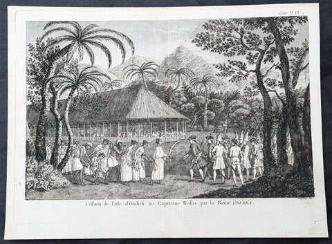
- Title : Cession de lisle D otahiti au Capitaine Wallis par la Reine Oberea (Surrender of the Island of Taahiti to Capt Wallis by Queen Obera)
- Size: 14in x 10in (365mm x 255mm)
- Ref #: 16089-1
- Date : 1774
- Condition: (A) Very Good Condition
Description:
This fine original copper-plate engraved antique print of Captain Samuel Wallis - the first European to visit Tahiti in 1767 - accepting surrender from Queen Purea (Oberea) of Tahiti, after the battle in Matavia Bay in 1767, was engraved by Robert Benard and was published in the 1774 French edition of John Hawkesworths An Account of the Voyages Undertaken by the Order of His Present Majesty for Making Discoveries in the Southern Hemisphere and Successively Performed by Commodore Byron, Captain Wallis, Captain Carteret, and Captain Cook, in the Dolphin, the Swallow, and the Endeavor, Drawn Up from the Journals Which Were Kept by the Several Commanders, and from the Papers of Joseph Banks, Esq. Paris 1774
From the log of Samuel Wallis, Captain of The Dolphin 1767.......
At two in the morning, it being very clear, we made sail again; at day-break we saw the land, at about five leagues distance, and steered directly for it; but at eight o’clock, when we were close under it, the fog obliged us again to lie to, and when it cleared away, we were much surprised to find ourselves surrounded by some hundreds of canoes…. When they came within pistol shot of the ship, they lay by, gazing at us with great astonishment, and by turns conferring with each other. In the mean time we showed them trinkets of various kinds, and invited them on board. Soon after, they drew together, and held a kind of council, to determine what should be done: then they all paddled around the ship, making signs of friendship, and one of them holding up a branch of the plantain tree, made a speech that lasted near a quarter of an hour, and then threw it into the sea. Soon after, as we continued to make signs of invitation, a fine, stout, lively young man ventured on board: he came up by the mizzen chains, and jumped out of the shrouds on top of the awning. We made signs to him to come down upon the quarter-deck, and handed up some trinkets to him: he looked pleased, but would accept of nothing till some of the Indians came alongside, and after much talk, threw a few branches of plantain tree on board the ship. He then accepted our presents, and several others very soon came on board.
As we had no anchorage here, we stood along the shore, sending the boats at the same time to sound at a less distance…. About three o’clock in the afternoon, we brought to, abreast of a large bay, where there was an appearance of anchorage. The boats were immediately sent to sound it, and while they were thus employed, I observed a great number of canoes gather round them. I suspected that the Indians had a design to attack them, and as I was very desirous to prevent mischief, I made the signal for the boats to come aboard, and at the same time, to intimidate the Indians, I fired a nine-pounder over their heads. As soon as the cutter began to stand towards the ship, the Indians in their canoes, though they had been startled by the thunder of our nine-pounder, endeavoured to cut her off. The boat, however, sailing faster than the canoes could paddle, soon got clear of those that were about her; but some others, that were full of men, waylaid her in her course, and threw several stones into her, which wounded some of the people. Upon this, the officer on board fired a musquet, loaded with buck-shot, at the man who threw the first stone, and wounded him in the shoulder. The rest of the people in the canoes, as soon as they perceived their companion wounded, leapt in to the sea, and the other canoes paddled away, in great terror and confusion.
General Definitions:
Paper thickness and quality: - Heavy and stable
Paper color : - off white
Age of map color: -
Colors used: -
General color appearance: -
Paper size: - 14in x 10in (365mm x 255mm)
Plate size: - 14in x 10in (365mm x 255mm)
Margins: - Min 1/2in (12mm)
Imperfections:
Margins: - None
Plate area: - Folds as issued
Verso: - None
Background:
Samuel Wallis 1728 – 1795
was a British naval officer and explorer of the Pacific Ocean.
Wallis was born near Camelford, Cornwall. He served under John Byron, and in 1766 was promoted to captain and was given the command of HMS Dolphin (1751) as part of an expedition led by Philip Carteret in the Swallow with an assignment to circumnavigate the globe. The two ships were parted by a storm shortly after sailing through the Strait of Magellan, Wallis continuing to Tahiti, which he named King George the Thirds Island in honour of the King (June 1767). Wallis himself was ill and remained in his cabin: lieutenant Tobias Furneaux was the first to set foot, hoisting a pennant and turning a turf, taking possession in the name of His Majesty. Dolphin stayed in Matavai Bay in Tahiti for over a month. Wallis went on to name or rename five more islands in the Society Islands and six atolls in the Tuamotu Islands, as well as confirming the locations of Rongerik and Rongelap in the Marshall Islands. He renamed the Polynesian island of Uvea as Wallis after himself, before reaching Tinian in the Mariana Islands. He continued to Batavia, where many of the crew died from dysentery, then via the Cape of Good Hope to England, arriving in May 1768. He was able to pass on useful information to James Cook who was due to depart shortly for the Pacific, and some of the crew from the Dolphin sailed with Cook. In 1780 Wallis was appointed Commissioner of the Admiralty.
Tahiti previously also known as Otaheite is the largest island in the Windward group of French Polynesia. The island is located in the archipelago of the Society Islands in the central Southern Pacific Ocean.
The first European to have visited Tahiti according to existing records was lieutenant Samuel Wallis, who was circumnavigating the globe in HMS Dolphin, sighting the island on 18 June 1767, and eventually harboring in Matavai Bay. This bay was situated on the territory of the chiefdom of Pare-Arue, governed by Tu (Tu-nui-e-a a-i-te-Atua) and his regent Tutaha, and the chiefdom of Ha apape, governed by Amo and his wife Oberea (Purea). Wallis named the island King Georges Island. The first contacts were difficult, since on the 24 and 26 June 1767, Tahitian warriors in canoes showed aggression towards the British, hurling stones from their slings. In retaliation, the British sailors opened fire on the warriors in the canoes and on the hills. In reaction to this powerful counter-attack, the Tahitians laid down peace offerings for the British. Following this episode, Samuel Wallis was able to establish cordial relations with the female chieftain “Oberea “ (Purea) and remained on the island until 27 July 1767.
In July 1768, Captain James Cook was commissioned by the Royal Society and on orders from the Lords Commissioners of the Admiralty to observe the transit of Venus across the sun, a phenomenon that would be visible from Tahiti on 3 June 1769. He arrived in Tahitis Matavai Bay, commanding the HMS Endeavour on 12 April 1769. On 14 April, Cook met with Tutaha and Tepau. On 15 April, Cook picked the site for a fortified camp at Point Venus along with Banks, Parkinson, Daniel Solander, to protect Charles Greens observatory. The length of stay enabled them to undertake for the first time real ethnographic and scientific observations of the island. Assisted by the botanist Joseph Banks, and by the artist Sydney Parkinson, Cook gathered valuable information on the fauna and flora, as well as the native society, language and customs, including the proper name of the island, Otaheite. On 28 April, Cook met Purea and Tupaia, and Tupaia befriended Banks following the transit. On 21 June, Amo visited Cook, and then on 25 June, Pohuetea visited, signifying another chief seeking to ally himself with the British.
Cook and Banks circumnavigated the island from 26 June to 1 July. On the exploration, they met Ahio, chief of Ha apaiano o or Papenoo, Rita, chief of Hitia a, Pahairro, chief of Pueu, Vehiatua, chief of Tautra, Matahiapo, chief of Teahupo o, Tutea, chief of Vaira o, and Moe, chief of Afa Ahiti. In Papara, guided by Tupaia, they investigated the ruins of Mahaiatea marae, an impressive structure containing a stone pyramid or ahu, measuring 44 feet high, 267 feet long and 87 feet wide. Cook and the Endeavour departed Tahiti on 13 July 1769, taking Raiatean navigator Tupaia along for his geographic knowledge of the islands.
Cook returned to Tahiti between 15 August and 1 September 1773, greeted by the chiefs Tai and Puhi, besides the youg ari i Vehiatua II and his stepfather Ti itorea. Cook anchored in Vaitepiha Bay before returning to Point Venus where he met Tu, the paramount chief. Cook picked up two passengers from Tahiti during this trip, Porea and Mai, with Hitihiti later replacing Porea when Cook stopped at Raiatea. Cook took Hitihiti to Tahiti on 22 April, during his return leg. Then, Cook departed Tahiti on 14 May 1774.
During his final visit, Cook returned Mai to Tahiti on 12 Aug. 1777, after Mais long visit in England. Cook also brought two Maori from Queen Charlotte Sound, Te Weherua and Koa. Cook first harbored in Vaitepiha Bay, where he visited Vehiatua II s funeral bier and the prefabricated Spanish mission house. Cook also met Vehiatua III, and inscribed on the back of the Spanish cross, Georgius tertius Rex Annis 1767, 69, 73, 74 & 77, as a counterpoint to Christus Vincit Carolus III imperat 1774 on the front. On 23 Aug., Cook sailed for Matavai Bay, where he met Tu, his father Teu, his mother Tetupaia, his brothers Ari ipaea and Vaetua, and his sisters Ari ipaea-vahine, Tetua-te-ahamai, and Auo. Cook also observed a human sacrifice, taata tapu, at the Utu-ai-mahurau marae, and 49 skulls from previous victims.
On 29 Sept. 1777, Cook sailed for Papetoai Bay on Moorea. Cook met Mahine in an act of friendship on 3 Oct., though he was an enemy of Tu. When a goat kid was stolen on 6 Oct., Cook in a rampage, ordered the burning of houses and canoes until it was returned. Cook sailed for Huahine on 11 Oct., Raiatea on 2 Nov., and Borabora on 7 Dec.
On 26 October 1788, HMS Bounty, under the command of Captain William Bligh, landed in Tahiti with the mission of carrying Tahitian breadfruit trees (Tahitian: uru) to the Caribbean. Sir Joseph Banks, the botanist from James Cooks first expedition, had concluded that this plant would be ideal to feed the African slaves working in the Caribbean plantations at very little cost. The crew remained in Tahiti for about five months, the time needed to transplant the seedlings of the trees. Three weeks after leaving Tahiti, on 28 April 1789, the crew mutinied on the initiative of Fletcher Christian. The mutineers seized the ship and set the captain and most of those members of the crew who remained loyal to him adrift in a ships boat. A group of mutineers then went back to settle in Tahiti.
Although various explorers had refused to get involved in tribal conflicts, the mutineers from the Bounty offered their services as mercenaries and furnished arms to the family which became the Pōmare Dynasty. The chief Tū knew how to use their presence in the harbours favoured by sailors to his advantage. As a result of his alliance with the mutineers, he succeeded in considerably increasing his supremacy over the island of Tahiti.
Robert Bénard 1734 – 1777 was an 18th-century French engraver.
Specialized in the technique of engraving, Robert Ménard is mainly famous for having supplied a significant amount of plates (at least 1,800) to the Encyclopédie by Diderot & d\'Alembert from 1751.
Later, publisher Charles-Joseph Panckoucke reused many of his productions to illustrate the works of his catalog.
1774 Hawkesworth Antique Print Queen Purea Surrender to Capt Wallis Tahiti, 1767
- Title : Cession de lisle D otahiti au Capitaine Wallis par la Reine Oberea (Surrender of the Island of Taahiti to Capt Wallis by Queen Obera)
- Size: 14in x 10in (365mm x 255mm)
- Ref #: 25925
- Date : 1774
- Condition: (A) Very Good Condition
Description:
This fine original copper-plate engraved antique print of Captain Samuel Wallis - the first European to visit Tahiti in 1767 - accepting surrender from Queen Purea (Oberea) of Tahiti, after the battle in Matavia Bay in 1767, was engraved by Robert Benard and was published in the 1774 French edition of John Hawkesworths An Account of the Voyages Undertaken by the Order of His Present Majesty for Making Discoveries in the Southern Hemisphere and Successively Performed by Commodore Byron, Captain Wallis, Captain Carteret, and Captain Cook, in the Dolphin, the Swallow, and the Endeavor, Drawn Up from the Journals Which Were Kept by the Several Commanders, and from the Papers of Joseph Banks, Esq. Paris 1774
From the log of Samuel Wallis, Captain of The Dolphin 1767.......
At two in the morning, it being very clear, we made sail again; at day-break we saw the land, at about five leagues distance, and steered directly for it; but at eight o’clock, when we were close under it, the fog obliged us again to lie to, and when it cleared away, we were much surprised to find ourselves surrounded by some hundreds of canoes…. When they came within pistol shot of the ship, they lay by, gazing at us with great astonishment, and by turns conferring with each other. In the mean time we showed them trinkets of various kinds, and invited them on board. Soon after, they drew together, and held a kind of council, to determine what should be done: then they all paddled around the ship, making signs of friendship, and one of them holding up a branch of the plantain tree, made a speech that lasted near a quarter of an hour, and then threw it into the sea. Soon after, as we continued to make signs of invitation, a fine, stout, lively young man ventured on board: he came up by the mizzen chains, and jumped out of the shrouds on top of the awning. We made signs to him to come down upon the quarter-deck, and handed up some trinkets to him: he looked pleased, but would accept of nothing till some of the Indians came alongside, and after much talk, threw a few branches of plantain tree on board the ship. He then accepted our presents, and several others very soon came on board.
As we had no anchorage here, we stood along the shore, sending the boats at the same time to sound at a less distance…. About three o’clock in the afternoon, we brought to, abreast of a large bay, where there was an appearance of anchorage. The boats were immediately sent to sound it, and while they were thus employed, I observed a great number of canoes gather round them. I suspected that the Indians had a design to attack them, and as I was very desirous to prevent mischief, I made the signal for the boats to come aboard, and at the same time, to intimidate the Indians, I fired a nine-pounder over their heads. As soon as the cutter began to stand towards the ship, the Indians in their canoes, though they had been startled by the thunder of our nine-pounder, endeavoured to cut her off. The boat, however, sailing faster than the canoes could paddle, soon got clear of those that were about her; but some others, that were full of men, waylaid her in her course, and threw several stones into her, which wounded some of the people. Upon this, the officer on board fired a musquet, loaded with buck-shot, at the man who threw the first stone, and wounded him in the shoulder. The rest of the people in the canoes, as soon as they perceived their companion wounded, leapt in to the sea, and the other canoes paddled away, in great terror and confusion.
General Definitions:
Paper thickness and quality: - Heavy and stable
Paper color : - off white
Age of map color: -
Colors used: -
General color appearance: -
Paper size: - 14in x 10in (365mm x 255mm)
Plate size: - 14in x 10in (365mm x 255mm)
Margins: - Min 1/2in (12mm)
Imperfections:
Margins: - None
Plate area: - Folds as issued
Verso: - None
Background:
Samuel Wallis 1728 – 1795
was a British naval officer and explorer of the Pacific Ocean.
Wallis was born near Camelford, Cornwall. He served under John Byron, and in 1766 was promoted to captain and was given the command of HMS Dolphin (1751) as part of an expedition led by Philip Carteret in the Swallow with an assignment to circumnavigate the globe. The two ships were parted by a storm shortly after sailing through the Strait of Magellan, Wallis continuing to Tahiti, which he named King George the Thirds Island in honour of the King (June 1767). Wallis himself was ill and remained in his cabin: lieutenant Tobias Furneaux was the first to set foot, hoisting a pennant and turning a turf, taking possession in the name of His Majesty. Dolphin stayed in Matavai Bay in Tahiti for over a month. Wallis went on to name or rename five more islands in the Society Islands and six atolls in the Tuamotu Islands, as well as confirming the locations of Rongerik and Rongelap in the Marshall Islands. He renamed the Polynesian island of Uvea as Wallis after himself, before reaching Tinian in the Mariana Islands. He continued to Batavia, where many of the crew died from dysentery, then via the Cape of Good Hope to England, arriving in May 1768. He was able to pass on useful information to James Cook who was due to depart shortly for the Pacific, and some of the crew from the Dolphin sailed with Cook. In 1780 Wallis was appointed Commissioner of the Admiralty.
Tahiti previously also known as Otaheite is the largest island in the Windward group of French Polynesia. The island is located in the archipelago of the Society Islands in the central Southern Pacific Ocean.
The first European to have visited Tahiti according to existing records was lieutenant Samuel Wallis, who was circumnavigating the globe in HMS Dolphin, sighting the island on 18 June 1767, and eventually harboring in Matavai Bay. This bay was situated on the territory of the chiefdom of Pare-Arue, governed by Tu (Tu-nui-e-a a-i-te-Atua) and his regent Tutaha, and the chiefdom of Ha apape, governed by Amo and his wife Oberea (Purea). Wallis named the island King Georges Island. The first contacts were difficult, since on the 24 and 26 June 1767, Tahitian warriors in canoes showed aggression towards the British, hurling stones from their slings. In retaliation, the British sailors opened fire on the warriors in the canoes and on the hills. In reaction to this powerful counter-attack, the Tahitians laid down peace offerings for the British. Following this episode, Samuel Wallis was able to establish cordial relations with the female chieftain “Oberea “ (Purea) and remained on the island until 27 July 1767.
In July 1768, Captain James Cook was commissioned by the Royal Society and on orders from the Lords Commissioners of the Admiralty to observe the transit of Venus across the sun, a phenomenon that would be visible from Tahiti on 3 June 1769. He arrived in Tahitis Matavai Bay, commanding the HMS Endeavour on 12 April 1769. On 14 April, Cook met with Tutaha and Tepau. On 15 April, Cook picked the site for a fortified camp at Point Venus along with Banks, Parkinson, Daniel Solander, to protect Charles Greens observatory. The length of stay enabled them to undertake for the first time real ethnographic and scientific observations of the island. Assisted by the botanist Joseph Banks, and by the artist Sydney Parkinson, Cook gathered valuable information on the fauna and flora, as well as the native society, language and customs, including the proper name of the island, Otaheite. On 28 April, Cook met Purea and Tupaia, and Tupaia befriended Banks following the transit. On 21 June, Amo visited Cook, and then on 25 June, Pohuetea visited, signifying another chief seeking to ally himself with the British.
Cook and Banks circumnavigated the island from 26 June to 1 July. On the exploration, they met Ahio, chief of Ha apaiano o or Papenoo, Rita, chief of Hitia a, Pahairro, chief of Pueu, Vehiatua, chief of Tautra, Matahiapo, chief of Teahupo o, Tutea, chief of Vaira o, and Moe, chief of Afa Ahiti. In Papara, guided by Tupaia, they investigated the ruins of Mahaiatea marae, an impressive structure containing a stone pyramid or ahu, measuring 44 feet high, 267 feet long and 87 feet wide. Cook and the Endeavour departed Tahiti on 13 July 1769, taking Raiatean navigator Tupaia along for his geographic knowledge of the islands.
Cook returned to Tahiti between 15 August and 1 September 1773, greeted by the chiefs Tai and Puhi, besides the youg ari i Vehiatua II and his stepfather Ti itorea. Cook anchored in Vaitepiha Bay before returning to Point Venus where he met Tu, the paramount chief. Cook picked up two passengers from Tahiti during this trip, Porea and Mai, with Hitihiti later replacing Porea when Cook stopped at Raiatea. Cook took Hitihiti to Tahiti on 22 April, during his return leg. Then, Cook departed Tahiti on 14 May 1774.
During his final visit, Cook returned Mai to Tahiti on 12 Aug. 1777, after Mais long visit in England. Cook also brought two Maori from Queen Charlotte Sound, Te Weherua and Koa. Cook first harbored in Vaitepiha Bay, where he visited Vehiatua II s funeral bier and the prefabricated Spanish mission house. Cook also met Vehiatua III, and inscribed on the back of the Spanish cross, Georgius tertius Rex Annis 1767, 69, 73, 74 & 77, as a counterpoint to Christus Vincit Carolus III imperat 1774 on the front. On 23 Aug., Cook sailed for Matavai Bay, where he met Tu, his father Teu, his mother Tetupaia, his brothers Ari ipaea and Vaetua, and his sisters Ari ipaea-vahine, Tetua-te-ahamai, and Auo. Cook also observed a human sacrifice, taata tapu, at the Utu-ai-mahurau marae, and 49 skulls from previous victims.
On 29 Sept. 1777, Cook sailed for Papetoai Bay on Moorea. Cook met Mahine in an act of friendship on 3 Oct., though he was an enemy of Tu. When a goat kid was stolen on 6 Oct., Cook in a rampage, ordered the burning of houses and canoes until it was returned. Cook sailed for Huahine on 11 Oct., Raiatea on 2 Nov., and Borabora on 7 Dec.
On 26 October 1788, HMS Bounty, under the command of Captain William Bligh, landed in Tahiti with the mission of carrying Tahitian breadfruit trees (Tahitian: uru) to the Caribbean. Sir Joseph Banks, the botanist from James Cooks first expedition, had concluded that this plant would be ideal to feed the African slaves working in the Caribbean plantations at very little cost. The crew remained in Tahiti for about five months, the time needed to transplant the seedlings of the trees. Three weeks after leaving Tahiti, on 28 April 1789, the crew mutinied on the initiative of Fletcher Christian. The mutineers seized the ship and set the captain and most of those members of the crew who remained loyal to him adrift in a ships boat. A group of mutineers then went back to settle in Tahiti.
Although various explorers had refused to get involved in tribal conflicts, the mutineers from the Bounty offered their services as mercenaries and furnished arms to the family which became the Pōmare Dynasty. The chief Tū knew how to use their presence in the harbours favoured by sailors to his advantage. As a result of his alliance with the mutineers, he succeeded in considerably increasing his supremacy over the island of Tahiti.
Robert Bénard 1734 – 1777 was an 18th-century French engraver.
Specialized in the technique of engraving, Robert Ménard is mainly famous for having supplied a significant amount of plates (at least 1,800) to the Encyclopédie by Diderot & d\'Alembert from 1751.
Later, publisher Charles-Joseph Panckoucke reused many of his productions to illustrate the works of his catalog.
1774 Hawkesworth Large Antique Map Chart of The Magellan Straits, South America
Antique Map
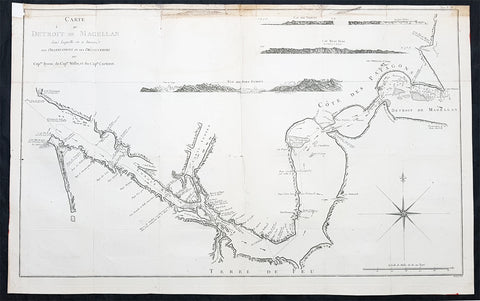
- Title : Carte Du Detroit De Magellan dans laquelle on a Insere Les Observations et Les Decouvertes Du Capne Byron, du Capne Wallis, et du Capne Carteret
- Ref : 32219
- Size: 30 1/2in x 21 1/2in (775mm x 545mm)
- Date : 1774
- Condition: (A) Very Good Condition
Description:
This large, original copper-plate engraved, antique map, a chart of the Straits of Magellan, South America and the Patagonian & South Chilean shoreline was engraved by Robert Benard and published in the 1774 French edition of John Hawkesworths An Account of the Voyages Undertaken by the Order of His Present Majesty for Making Discoveries in the Southern Hemisphere and Successively Performed by Commodore Byron, Captain Wallis, Captain Carteret, and Captain Cook, in the Dolphin, the Swallow, and the Endeavor, Drawn Up from the Journals Which Were Kept by the Several Commanders, and from the Papers of Joseph Banks
A large scale chart with detailed shoreline topography, channels, soundings, shoals, harbors and small islands. There are also anchorages, capes & bays as well as 4 finely engraved landfall approach views of
1.Vue Du Port Famine
2. Cap Beau Tems
3.Cap Des Vierges
4. Rochers blanc. (white rocks).
The tracks and some details in this chart are attributed to the following navigators;
Commodore Byron, Captain Wallis and Captain Carteret.
General Definitions:
Paper thickness and quality: - Heavy and stable
Paper color : - off white
Age of map color: - Early
Colors used: - Yellow, green, brown
General color appearance: - Authentic
Paper size: - 30 1/2in x 21 1/2in (775mm x 545mm)
Plate size: - 30in x 20in (765mm x 510mm)
Margins: - Min 1/2in (12mm)
Imperfections:
Margins: - Soiling to top margin and border, repair to top left corner
Plate area: - Folds as issued
Verso: - Folds as issued
Background:
The Strait of Magellan
(Estrecho de Magallanes) is a navigable sea route separating mainland South America to the north and Tierra del Fuego to the south. The strait is the most important natural passage between the Atlantic and Pacific oceans.
Ferdinand Magellan a Portuguese explorer and navigator in the service of Charles I of Spain, became the first European to navigate the strait in 1520 during his circumnavigation of the globe.
Other early explorers included Francis Drake (1578). In February 1696 the first French expedition, under the command of M. de Gennes reached the Strait of Magellan. The expedition is described by the young French explorer, engineer and hydrographer François Froger in his A Relation of a Voyage (1699).
The strait was first carefully explored and thoroughly charted by Phillip Parker King, who commanded the British survey vessel HMS Adventure, and in consort with HMS Beagle spent five years surveying the complex coasts around the strait (1826–1830). A report on the survey was presented at two meetings of the Geographical Society of London in 1831.
The 3 Voyages, with Captains, ships & tracks who contributed to this map are;
1. 1764-66 - HMS Dolphin under Command of Commodore John Byron, completed the first circumnavigation of the globe under two years.
2. 1766-68 - HMS Dolphin under Command of Captain Samuel Wallis, completed another circumnavigation & was the first European to visit Tahiti & the Society Islands.
3. 1766-68 - HMS Swallow under Command of Captain Philip Carteret, who accompanied HMS Dolphin under the command of Samuel Wallis to circumnavigate the world.
John Hawkesworth an English writer and journalist, Hawkesworth was commissioned by the British Admiralty to edit for publication the narratives of its officers’ circumnavigations. He was given full access to the journals of the commanders and the freedom to adapt and re-tell them in the first person. Cook was already on his way back from his second Pacific voyage, temporarily docked at Cape Town (South Africa), when he first saw the published volumes: he was mortified and furious to find that Hawkesworth claimed in the introduction that Cook had seen and blessed (with slight corrections) the resulting manuscript. (In his defense, Hawkesworth also had been a victim of misunderstanding.) Cook had trouble recognizing himself. Moreover, the work was full of errors and commentary introduced by Hawkesworth and, in Cook’s view, too full of Banks, who had promoted himself and the publication. Still, the work was popular; the first edition sold out in several months.
Robert Bénard 1734 – 1777 was an 18th-century French engraver.
Specialized in the technique of engraving, Robert Ménard is mainly famous for having supplied a significant amount of plates (at least 1,800) to the Encyclopédie by Diderot & d Alembert from 1751.
Later, publisher Charles-Joseph Panckoucke reused many of his productions to illustrate the works of his catalog.
1774 Hawkesworth Large Antique Map of Australia & South Seas 1765-71 - Capt Cook
Antique Map
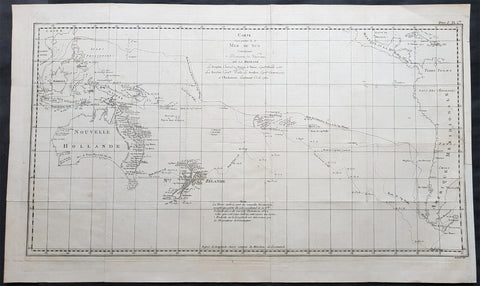
- Title : Carte d une Partie de la Mer du Sud Contenant les Decouvertes de Vaisseaux de sa Majeste, Le Dauphin, Commodore Byron, La Tamar, Capitne. Mouats 1765, Le Dauphin, Capitne. Wallis, Le Swallow, Capitne. Cartaret, 1767, et l Endeavour, Lieutenant Cook 1769
- Ref : 35509
- Size: 28in x 16 3/4in (710mm x 425mm)
- Date : 1774
- Condition: (A+) Fine Condition
Description:
This fine original copper-plate engraved, large antique map, a chart of the tracks of 5 British ships & explorers to the South Ocean from 1765 to 1771 was engraved by Robert Benard and published in the 1774 French translation of John Hawkesworths publication An Account of the Voyages Undertaken by the Order of His Present Majesty for Making Discoveries in the Southern Hemisphere and Successively Performed by Commodore Byron, Captain Wallis, Captain Carteret, and Captain Cook, in the Dolphin, the Swallow, and the Endeavor, Drawn Up from the Journals Which Were Kept by the Several Commanders, and from the Papers of Joseph Banks
The 5 Voyages, with Captains, ships & tracks are;
1. 1764-66 - HMS Dolphin under Command of Commodore John Byron, completed the first circumnavigation of the globe under two years.
2. 1764-1766 - HMS Tamar under Command of Captain Patrick Mouat, accompanied Commodore John Byron & HMS Dolphin on 1764-66 circumnavigation of the world.
3. 1766-68 - HMS Dolphin under Command of Captain Samuel Wallis, completed another circumnavigation & was the first European to visit Tahiti & the Society Islands.
4. 1766-68 - HMS Swallow under Command of Captain Philip Carteret, who accompanied HMS Dolphin under the command of Samuel Wallis to circumnavigate the world.
5. 1769-71 - HMS Endeavour, under Command of Lieutenant James Cook (later Captain) completed a the mapping of Tahiti & the Society Islands, New Zealand & the East Coast of Australia.
General Definitions:
Paper thickness and quality: - Heavy and stable
Paper color : - off white
Age of map color: -
Colors used: -
General color appearance: -
Paper size: - 28in x 16 3/4in (710mm x 425mm)
Plate size: - 26 3/4in x 14 3/4in (680mm x 375mm)
Margins: - Min 1/2in (12mm)
Imperfections:
Margins: - None
Plate area: - Folds as issued
Verso: - None
Background:
Commodore John Byron 1723 – 1786 was a British Royal Navy officer and politician.He circumnavigated the world as a commodore with his own squadron in 1764-1766. He fought in battles in The Seven Years War and the American Revolution. He rose to Vice Admiral before his death in 1786.
Captain Patrick Mouat. Commanded HMS Tamer on a voyage of discovery with Commodore John Byron between 1764-66. HMS Tamar was a sloop, mounting sixteen guns: ninety men, three lieutenants, and two and twenty petty officers.
Captain Samuel Wallis 1728 – 1795 was a British naval officer and explorer of the Pacific Ocean. Was given the command of HMS Dolphin in 1751 as part of an expedition led by Philip Carteret in the Swallow with an assignment to circumnavigate the globe. The two ships were parted by a storm shortly after sailing through the Strait of Magellan, Wallis continuing to Tahiti, which he named King George the Third\'s Island in honour of the King in June 1767.
Captain Philip Carteret 1733 – 1796 was a British naval officer and explorer who participated in two of the Royal Navys circumnavigation expeditions in 1764–66 and 1766–69.
Captain James Cook is considered one of the most talented Surveyors & Map Makers of any age, for Cook, the production of a new chart was his principal reason for going to sea. His charts were aimed at fellow seamen so he incorporated as much information as possible while employing an economy of style and little elaboration. The quality of his charts can be confirmed by the fact that some survey details from Newfoundland to New Zealand & Australias East Coast could still be safely used over one hundred years later. His last piece of the New Zealand hydrographic chart was only removed in the 1990s.
John Hawkesworth An English writer and journalist, Hawkesworth was commissioned by the British Admiralty to edit for publication the narratives of its officers’ circumnavigations. He was given full access to the journals of the commanders and the freedom to adapt and re-tell them in the first person. Cook was already on his way back from his second Pacific voyage, temporarily docked at Cape Town (South Africa), when he first saw the published volumes: he was mortified and furious to find that Hawkesworth claimed in the introduction that Cook had seen and blessed (with slight corrections) the resulting manuscript. (In his defense, Hawkesworth also had been a victim of misunderstanding.) Cook had trouble recognizing himself. Moreover, the work was full of errors and commentary introduced by Hawkesworth and, in Cook’s view, too full of Banks, who had promoted himself and the publication. Still, the work was popular; the first edition sold out in several months.
Robert Bénard 1734 – 1777 was an 18th-century French engraver.
Specialized in the technique of engraving, Robert Ménard is mainly famous for having supplied a significant amount of plates (at least 1,800) to the Encyclopédie by Diderot & d Alembert from 1751.
Later, publisher Charles-Joseph Panckoucke reused many of his productions to illustrate the works of his catalog.

1774 Malachy Postlethwayt Antique 2 Volume Atlas 7 Large Cont Maps North America
Antique Map
- Title : The Universal Dictionary of Trade and Commercewith large Improvements Adapting the Same to the Present State of British Affairs in America since the last Treaty of Peace made in the year 1763....MDCCLXXIV
- Ref #: 93529
-
Condition: (A+) Fine Condition
- Size: Large Folio
- Date : 1774
Description:
These very large, heavy leather backed original antique dictionary & atlas volumes of early Global Economic Commerce by Malachy Postlethwayt was published in 1774.
The Universal Dictionary of Trade and Commerce in 2 volumes is the 4th edition published in London by W. Strahan, J and F. Rivington, et al., in 1774. The first edition was published between 1751 & 1755. Titles in red and black with engraved vignettes, engraved allegorical frontispiece to volume 1 (offset onto title) and contain 24 engraved folding maps sheets that when assembled make 7 complete very large maps. Occasional minor spotting, contemporary diced calf, re-backed preserving original contrasting morocco labels, extremities repaired.
The seven maps once assembled, to the left, are as follows with titles, cartographers dates and dimensions;:
1. A Correct Map of Europe by Thomas Kitchin after D Anville, 80cm x 70cm, 1774
2. Africa Performed by the Sr D Anville Samuel Bolton after D Anville, 103cm x 94cm, 1774
3. A New and Correct Map of the Coast of Africa, so called Slave Coast Map, Richard Seale 48cm x 38cm, 1774
4. North America Performed under the Patronage of Louis Duke of Orleans Richard Seale after D Anville, 88cm x 86cm, 1774
5. South America Thomas Kitchin after D Anville, 124cm x 75cm, 1774
6. First Part of Asia RW Seale, after D Anville, 83cm x 77cm, 1755
7. Second Part of Asia R W Seale, after D Anville, 96cm x 70cm, 1755
General Definitions:
Paper thickness and quality: - Heavy and stable
Paper color : - off white
Age of map color: -
Colors used: -
General color appearance: -
Paper size: - Please see above
Plate size: - Please see above
Margins: - Please see above
Imperfections:
Margins: - Please see above
Plate area: - Please see above
Verso: - Please see above
Background:
Postlethwayts most noted work, The Universal Dictionary of Trade and Commerce, appeared after he had devoted twenty years to its preparation. The first edition was published in London in instalments between 1751 and 1755, and then in subsequent editions as a two-volume set in 1757, 1766, and 1774. This dictionary was a translation, with large additions and improvements, from Jacques Savary des Bruslons Dictionnaire universal de commerce (1723–1730). Postlethwayts dictionary was a huge storehouse of economic facts, laws and theory and his departures from the French version reflected his greater interest in political problems; his more intense economic nationalism; and his exuberant belief in the economic usefulness of experimental philosophy
In the 1757 edition of the Universal Dictionary, Postlethwayt outlined his vision for the establishment of a British mercantile college to benefit those who intended to work as merchants, or in gathering public revenue, or in merchandizing. He proposed that theoretical training for business should occur in formal academies and involve the study of mercantile computations, foreign exchanges and the intrinsic value of foreign coins, double-entry accounting, languages, geography, and public revenues and related laws. Postlethwayts ideas appear to have been influential in developing the statutes and procedures of the Portuguese School of Commerce, established in Lisbon in 1759.
It is documented that Thomas Jefferson gave a copy of this dictonary to his son in law, Thomas Mann Randolph, and as a prolific reader we must assumed also read by Jefferson.
Postlethwayt, Malachy 1707-1767
Malachy Postlethwayt was a prolific English writer and publicist on matters of mercantilist economics in the 1740s and 1750s. Little is known about his upbringing or formal education, although he is believed to be the brother of James Postlethwayt (d. 1761), a writer on finance and demography. Malachy Postlethwayt was elected a fellow of the Society of Antiquaries of London in 1734. His writings are claimed by Edgar Johnson to have exerted a good deal of influence on the trend of British economic thought.
Postlethwayt was alleged to be propagandist for the mercantilist endeavours of the Royal Africa Company, whose interests were well served by his publications The African Trade, the Great Pillar and Supporter of the British Plantation Trade in North America (1745) and The National and Private Advantages of the African Trade Considered (1746). These works supported a strategy of British commercial and manufacturing expansion through trade with Africa and the colonies, and promoted the importance of slavery for British commerce and industry.
Postlethwayts most noted work, The Universal Dictionary of Trade and Commerce, appeared after he had devoted twenty years to its preparation. The first edition was published in London in instalments between 1751 and 1755, and then in subsequent editions as a two-volume set in 1757, 1766, and 1774. This dictionary was a translation, with large additions and improvements, from Jacques Savary des Bruslons Dictionnaire universal de commerce (1723–1730). Postlethwayts dictionary was a huge storehouse of economic facts, laws and theory and his departures from the French version reflected his greater interest in political problems; his more intense economic nationalism; and his exuberant belief in the economic usefulness of experimental philosophy
In the 1757 edition of the Universal Dictionary, Postlethwayt outlined his vision for the establishment of a British mercantile college to benefit those who intended to work as merchants, or in gathering public revenue, or in merchandizing. He proposed that theoretical training for business should occur in formal academies and involve the study of mercantile computations, foreign exchanges and the intrinsic value of foreign coins, double-entry accounting, languages, geography, and public revenues and related laws. Postlethwayts ideas appear to have been influential in developing the statutes and procedures of the Portuguese School of Commerce, established in Lisbon in 1759.
Postlethwayts most important contribution to economic literature is regarded by many to be Britains Commercial Interest Explained and Improved (1757), in which he outlines his concept of physical commerce and the policies England should follow to attain commercial parity with foreign rivals.
Whether Postlethwayts writings were his original thoughts and words is a matter for conjecture. His Universal Dictionary included ideas taken from fifty other past or contemporary writers and that it had scattered throughout it practically all of Richard Cantillons Essai sur la nature du commerce en général (Essay on the Nature of Commerce in General, 1755). Although Postlethwayt was alleged widely to be a plagiarist, this accusation is believed to be exaggerated.
Postlethwayt died suddenly on September 13, 1767, and was buried in the Old Street Churchyard, Clerkenwell, in London.
Postlethwayt also published:
- The African Trade the great Pillar and Support of the British Plantation Trade in America, &c., 1745.
- The Natural and Private Advantages of the African Trade considered, &c., 1746.
- Britains Commercial Interest Explained, Vol. I of his Universal Dictionary of Trade and Commerce, 1747.[5]
- Considerations on the making of Bar Iron with Pitt or Sea Coal Fire, &c. In a Letter to a Member of the House of Commons, London, 1747.
- Considerations on the Revival of the Royal-British Assiento, between his Catholic Majesty and the … South-Sea Company. With an … attempt to unite the African-Trade to that of the South-Sea Company, by Act of Parliament, London, 1749.
- The Merchants Public Counting House, or New Mercantile Institution, &c., London, 1750.
- A Short State of the Progress of the French Trade and Navigation, &c., London, 1756.
- Great Britains True System. … To which is prefixed an Introduction relative to the Forming a New Plan of British Politicks with respect to our Foreign Affairs, &c., London, 1757.
- Britains Commercial Interest explained and improved, in a Series of Dissertations on several important Branches of her Trade and Police. … Also … the Advantages which would accrue … from an Union with Ireland, 2 vols., London, 1757; 2nd edit., With … a clear View of the State of our Plantations in America, &c., London, 1759.
- In Honour to the Administration. The importance of the African Expedition considered, &c., London, 1758
Please note all items auctioned are genuine, we do not sell reproductions. A Certificate of Authenticity (COA) can be issued on request.

1774, 1777 & 1785 Capt James Cook 3 Atlas Volumes 1st Editions 204 Maps & Prints
- Title : 1. Figure du Banks 2. Premier Voyage De Cook 3. Troisieme Voyage De Cook
- Ref #: 93498, 93499, 93500
- Size: 4to (Quatro)
- Date : 1774; 1777; 1785
- Condition: (A+) Fine Condition
Description:
A unique and rare opportunity to acquire all three of Captain James Cooks 1st French edition Atlases (4to, Quatro), published to accompany the publication of his 3 voyages of discovery in 1774, 1777 & 1785. The atlases contain a total of 204 large folding, double page and single page maps and prints. It is very rare to find all three atlases complete and available together at the same time.
The contents of all three atlases are in fine condition, with a fresh, heavy impression and clean paper of all maps and prints.
As stated there are 204 maps and prints 51 in the 1st volume, 66 in the second volume and 87 in the second volume. Please view the images above, that include a few images of the 204 maps and prints as well as an itemized list of each volume.
General Definitions:
Paper thickness and quality: - Heavy and stable
Paper color : - off white
Age of map color: -
Colors used: -
General color appearance: -
Paper size: - 4to (Quatro)
Plate size: - 4to (Quatro)
Margins: - 4to (Quatro)
Imperfections:
Margins: - Some scuffing and wear to boards & spines
Plate area: - None
Verso: - None
Background:
Timeline First Voyage 1768 - 1771:
In 1768 Cook was chosen to lead an expedition to the South Seas to observe the Transit of Venus and to secretly search for the unknown Great Southern Continent (terra australis incognita).
Cook and his crew of nearly 100 men left Plymouth (August 1768) in the Endeavour and travelled via Madeira (September), Rio de Janiero (November-December) and Tierra del Fuego (January 1769) to Tahiti.
At Tierra del Fuego (January 1769) Cooks men went ashore and met the local people whom Cook thought perhaps as miserable a set of People as are this day upon Earth. Joseph Bankss party collected botanical specimens but his two servants, Thomas Richmond and George Dorlton, died of exposure in the snow and cold. Leaving Tierra del Fuego Endeavour rounded Cape Horn and sailed into the Pacific Ocean.
Sir Joseph Banks wrote about the homes of the Fuegans
..…huts or wigwams of the most unartificial construction imaginable, indeed no thing bearing the name of a hut could possibly be built with less trouble. They consisted of a few poles set up and meeting together at the top in a conical figure, these were covered on the weather side with a few boughs and a little grass, on the lee side about one eighth part of the circle was left open and against this opening was a fire made.......(Banks, Journal I, 224, 20th January 1769)
Samuel Wallis on the ship Dolphin discovered Tahiti in 1767. He recommended the island for the Transit of Venus observations and Cook arrived here in April 1769. Cook, like Wallis two years before him, anchored his ship in the shelter of Matavai Bay on the western side of the island.
In Matavai Bay Cook established a fortified base, Fort Venus, from which he was to complete his first task – the observation of the Transit of Venus (3rd June 1769). The fort also served as protection for all the important scientific and other equipment which had to be taken ashore as:
.......great and small chiefs and common men are firmly of opinion that if they can once get possession of an thing it immediately becomes their own…the chiefs employd in stealing what they could in the cabbin while their dependents took every thing that was loose about the ship…...(Joseph Banks).
Theft by some native peoples plagued Cooks voyages.
Cook and his crew experienced good relations with the Tahitians and returned to the islands on many occasions, attracted by the friendly people of this earthly paradise. On arrival Cook had set out the rules, including:
.....To endeavour by every fair means to cultivate a friendship with the Natives and to treat them with all imaginable humanity....
Just as Cook was planning to leave Tahiti two members of Endeavours crew decided to desert, having strongly attached themselves to two girls, but Cook recovered them.
Cook sailed around the neighbouring Society Islands and took on board the Tahitian priest, Tupaia, and his servant, Taiata. Endeavour left the Society Island in August 1769.
Tupaia acted as interpreter when they came into contact with other Polynesian peoples and helped Cook to make a map of the Pacific islands. This showed Cook the location of islands arranged according to their distance from Tahiti and indicated Tupaias and Polynesian knowledge of navigation and their skill as great mariners.
Cook sailed in search of the Southern Continent (August-October 1769) before turning west to New Zealand. The first encounters with the native Maori of New Zealand in October were violent, their warriors performing fierce dances, or hakas, in attempts to threaten and challenge the ships crew. Some of their warriors were killed when Cooks men had to defend themselves. Eventually relations improved and Cook was able to trade with the Maori for fresh supplies.
Exploring different bays and rivers along the way Cook circumnavigated New Zealand and was the first to accurately chart the whole of the coastline. He discovered that New Zealand consisted of two main islands, north (Te Ika a Maui) and south (Te Wai Pounamu) islands (October 1769-March 1770).
The artist Sydney Parkinson described three Maori who visited the Endeavour on 12th October 1769:
......Most of them had their hair tied up on the crown of their heads in a knot…Their faces were tataowed, or marked either all over, or on one side, in a very curious manner, some of them in fine spiral directions…
This Maori wears an ornamental comb, feathers in a top-knot, long pendants from his ears and a heitiki, or good luck amulet, around his neck.
At the northern end of the south island Cook anchored the ship in Ship Cove, Queen Charlotte Sound, which became a favourite stopping place on the following voyages. Parkinson noted:
......The manner in which the natives of this bay (Queen Charlotte Sound) catch their fish is as follows: - They have a cylindrical net, extended by several hoops at the bottom, and contracted at the top; within the net they stick some pieces of fish, then let it down from the side of the canoe and the fish, going in to feed, are caught with great ease.....(Parkinson, Journal, 114)
In Queen Charlottes Sound Cook visited one of the many Maori hippah, or fortified towns.
........The town was situated on a small rock divided from the main by a breach in a rock so small that a man might almost Jump over it; the sides were every where so steep as to render fortifications iven in their way almost totally useless, according there was nothing but a slight Palisade…in one part we observed a kind of wooden cross ornamented with feathers made exactly in the form of a crucifix cross…we were told that it was a monument to a dead man.......
Endeavour left New Zealand and sailed along the east coast of New Holland, or Australia, heading north (April-August 1770). Cook started to chart the east coast and on 29th April landed for the first time in what Cook called Stingray, later, Botany Bay.
The ship struck the Great Barrier Reef and was badly damaged (10 June). Repairs had to be carried out in Endeavour River. (June-August 1770). The first kangaroo to be sighted was recorded and shot.
The inhabitants of New Holland were very different from the people Cook had come across in other Pacific lands. They were darker skinned than the Maori and painted their bodies:
......They were all of them clean limnd, active and nimble. Cloaths they had none, not the least rag, those parts which nature willingly conceals being exposed to view compleatly uncovered......(Joseph Banks)
Tupaia could not make himself understood and at first the aborigines were very wary of the visitors and not at all interested in trading.
Joseph Banks recorded the fishing party observed at Botany Bay on 26 April 1770. He wrote:
......Their canoes… a piece of Bark tied together in Pleats at the ends and kept extended in the middle by small bows of wood was the whole embarkation, which carried one or two…people…paddling with paddles about 18 inches long, one of which they held in either hand.....(Banks, Journal II, 134)
Endeavour left Australia and sailed via the Possession Isle and Endeavour Strait for repairs at Batavia, Java (October-December 1770). Although the crew had been quite healthy and almost free from scurvy, the scourge of sailors, many caught dysentery and typhoid and over thirty died at Batavia or on the return journey home via Cape Town, South Africa (March-April 1771). The ship arrived off Kent, England (July 1771).
The voyage successfully recorded the Transit of Venus and largely discredited the belief in a Southern Continent. Cook charted the islands of New Zealand and the east coast of Australia and the scientists and artists made unique records of the peoples, flora and fauna of the different lands visited.
Timeline - Second Voyage 1772 - 1775
In July 1772 Resolution, commanded by Captain Cook, and Discovery, commanded by Lieutenant Furneaux, set sail from Britain, via Madiera (Jul-Aug) and Cape Town, South Africa (Oct-Nov), towards the Antarctic in search of the Great Southern Continent.
During January 1773 the ships took on fresh water, charts of the voyage being marked with:
......Here we watered our Ship with Ice the 1st. Time 26S 44W and Here we compleated our Water/26S 20W but became separated in thick fog: Here we parted company…. and The Resolutions Track after we parted Company on the 8 of February 1773......
The ships became the first known to have crossed the Antarctic Circle (17 January 1773). On 9th January Cook wrote:
.......we hoisted out three Boats and took up as much as yielded about 15 Tons of Fresh Water, the Adventure at the same time got about 8 or 9 and all this was done in 5 or 6 hours time; the pieces we took up and which had broke from the Main Island, were very hard and solid, and some of them too large to be handled so that we were obliged to break them with our Ice Azes before they could be taken into the Boats...... Cook, Journals II, 74.)
The ships met again in New Zealand (February-May 1773) and set off to explore the central Pacific, calling at Tahiti (August), where, from the island of Raiatea, they took aboard Omai who returned with the Adventure to England (7 September).
After visiting Amsterdam and Middelburg, two islands that Cook called the Friendly Islands (Tongan group) (October) the ships became separated and never met again. Both ships returned separately to New Zealand. (November) A boats crew from the Adventure were killed by Maori (17 December) and the ship sailed for Britain, arriving July 1774.
Cook on Resolution attempted another search for the Great Southern Continent (November 1773), crossing the Antarctic Circle on 20th December 1773. However, the ice and cold soon forced him to turn north again and he made another search in the central Pacific for the Great Southern Continent. In January 1774 he turned south again, crossing the Antarctic Circle for the second time. Captain Cooks Journal, 2nd January 1774.
Cook sailed north, arriving at Easter Island in March 1774. Cook was too ill to go ashore but a small party explored the southern part of the island. The artist William Hodges painted a group of the large statues of heads (moia) for which the island has become famous.
Cook then sailed to the Marquesas (March); Tahiti (April) and Raiatea (June); past the Cook Islands and Niue, or Savage Islands as Cook called them; Tonga (June); Vatoa, the only Fijian Island visited by Cook (July); New Hebrides (July-August); New Caledonia (September) and Norfolk Island (October); before returning to New Zealand (October 1774).
Not all the peoples of the islands visited by Cook were friendly and when his ship approached Niue the local people would not let his crew ashore. Cook wrote:
.......The Conduct and aspect of these Islanders occasioned my giving it the Name of Savage Island, it lies in the Latitude of 19 degrees 1 Longitude 169 degrees 37 West, is about 11 Leagues in circuit, of a tolerable height and seemingly covered with wood amongst which were some Cocoa-nutt trees......(Cook, Journals II, 435, 22 June 1774.)
En route for New Zealand, Cook sailed west and explored the islands which he called the New Hebrides, now known as Vanuatu, arriving on 17 July 1774. The people were Melanesian, not Polynesian, and spoke different languages and had different customs. Cook recorded:
........The Men go naked, it can hardly be said they cover their Natural parts, the Testicles are quite exposed, but they wrap a piece of cloth or leafe round the yard (nautical slang for the penis) which they tye up to the belly to a cord or bandage which they wear round the waist just under the Short ribs and over the belly and so tight that it was a wonder to us how they could endure it.......(Cook, Journals II, 464, 23 July 1774)
Cook sailed past or visited nearly all the islands in the group, including landfalls at Malekula, Tanna and Erromango. He later moved on to New Caledonia.
Cooks reception by the New Hebrideans was generally hostile. At Erromango during the landing on 4th August 1774 the marines had to open fire when the natives tried to seize the boat and started to fire missiles. Cook wrote:
....…I was very loath to fire upon such a Multitude and resolved to make the chief a lone fall a Victim to his own treachery…happy for many of these poor people not half our Musquets would go of otherwise many more must have fallen.......(Cook, Journals II, 479, 4th August 1774)
Some of Cooks crew were slightly injured but several natives were wounded and their leader killed. Back on the ship Cook had a gun fired to frighten off the islanders and decided to depart.
Cook left New Zealand to return to Britain via the Southern Ocean in November 1774 and arrived in Tierra del Fuego, South America, in December. Cook took on stores and spent the holiday in what he called Christmas Sound. He described the area:......except those little tufts of shrubbery, the whole country was a barren Tack (or Rock) doomed by Nature to everlasting sterility......(Cook, Ms Journal PRO Adm 55/108)
Cook left South America in early January 1775 and set off across the southern Atlantic for Cape Town, South Africa. On the way he tried to confirm the location of a number of islands charted by Alexander Dalrymple on an earlier voyage. On 17 January 1775 Cook arrived at the cold, bleak, glaciated island he called South Georgia and spent 3 days charting it before sailing on.
Cook headed east and in late January came across the South Sandwich Islands that he again charted and then sailed on to Cape Town, arriving in late March 1775. He then headed across the Atlantic via St. Helena and Ascension Island (May), the Azores (July) and landed at Portsmouth on 30th July 1775.
On his return Cook became a national hero. He was presented to the King, made a member of the Royal Society and received its Copley Medal for achievement. Cook was promoted to post-captain of Greenwich Hospital and wrote up his account of the voyage. This did not mean retirement for Cook who went on his third and final voyage the following year.
The second voyage was one of the greatest journeys of all time. During the three years the ships crews had remained healthy and only four of the Resolutions crew had died. Cook disproved the idea of the Great Southern Continent; had become the first recorded explorer to cross the Antarctic Circle; and had charted many Pacific islands for the first time.
Timeline - Third Voyage 1776 - 1780
In 1776 Cook sailed in a repaired Resolution (July) to search for the North West Passage and to return Omai to his home on Huahine in the Society Islands.
He sailed via the Canary Islands and was joined at Cape Town, South Africa, by the Discovery, commanded by Charles Clerke.
The Discovery was the smallest of Cooks ships and was manned by a crew of sixty-nine. The two ships were repaired and restocked with a large number of livestock and set off together for New Zealand ( December).
Cook sailed across the South Indian Ocean and confirmed the location of Desolation Island, later known as Kerguelen Island. Cook wrote of Christmas Harbour where he first anchored on 25th December 1776:
........I found the shore in a manner covered with Penguins and other birds and Seals…so fearless that we killed as ma(n)y as we chose for the sake of their fat or blubber to make Oil for our lamps and other uses… Here I displayd the British flag and named the harbour Christmas harbour as we entered it on that Festival........(Cook, Journals III, i, 29-32)
Cook sailed east, arriving at Van Diemens Land/Tasmania (January 1777) and Queen Charlottes Sound, New Zealand (February). The Maori were wary at first, expecting Cook to take revenge for the killing of members of the Adventures crew in 1773, but instead Cook befriended the leader of the attack.
The ships stayed for nearly two weeks in New Zealand, restocking with wild celery and scurvy grass and trading with the local Maori who set up a small village in Ship Cove. Cook set off around the islands of the south Pacific (February), visiting the Cook Islands (April); Tongan Islands (July); and Tahiti (August-December 1777)
In 1778 Cook visited the Hawaiian islands, or Sandwich Islands as he named them, for the first time. Cook wrote:
........We no sooner landed, that a trade was set on foot for hogs and potatoes, which the people gave us in exchange for nails and pieces of iron formed into some thing like chisels….At sun set I brought every body on board, having got during the day Nine tons of water….about sixty or eighty Pigs, a few Fowls, a quantity of potatoes and a few plantains and Tara roots.......(Cook, Journals III, i. 269 & 272)
In February 1778 Cook sailed from the Hawaiian Islands across the north Pacific to the Oregan coast of North America. He travelled up the coast in bad weather until he found a safe harbour, Nootka Sound, Vancouver Island, Canada. There he refitted the ships, explored the area and developed relations with the local people.
Cook described a village there, probably Yoquot:
….their houses or dwellings are situated close to the shore…Some of these buildings are raised on the side of a bank, theses have a flooring consisting of logs supported by post fixed in the ground….before these houses they make a platform about four feet broad…..so allows of a passage along the front of the building: They assend to this passage (along the front of the building) by steps, not unlike some at our landing places in the River Thames........(Cook, Journals III, i, 306)
Cook left Nootka Sound in April 1778 and sailed north along the Alaskan coast looking for inlets that might lead to the Northwest passage but was then forced to turn south. By July he had rounded the Alaskan Peninsula and was able to sail north again, visiting the Chukotskiy Peninsula, Russia, before heading out into the Bering Sea.
Cook described the summer huts, or yarangas, of the Chukchi people as:
.........pretty large, and circular and brought to a point at the top; the framing was of slight poles and bone, covered with the skins of Sea animals…About the habitations were erected several stages ten or twelve feet high, such as we had observed on some part of the American coast, they were built wholly of bones and seemed to be intended to dry skins, fish &ca. upon, out of reach of their dogs........(Cook, Journals III, I, 413)
After entering the Bering Sea on 11th August 1778, Cook crossed the Arctic Circle and went as far north as latitude 70 degrees 41 North before being forced back by the pack ice off Icy Cape, Alaska. On the ice all around the ships were large numbers of walruses. About a dozen of these huge animals were killed to replenish the supplies of fresh meat and to provide oil for the lamps.
Cook had to turn west and worked his way down the Russian coast, eventually heading south and east into Norton Sound, Alaska, in September 1778. He wrote of their very brief encounter with the inhabitants of Norton Sound:
....…a family of the Natives came near to the place where we were taking off wood…I saw no more than a Man, his wife and child…...(Cook, Journals III, I, 438)
After a short period spent searching for the Northwest Passage Cook realised that it was too late in the year to make any progress and so sailed for warmer winter quarters in the Hawaiian Islands, arriving there in December 1778.
After circumnavigating the big island of Hawaii for over a month the ships finally anchored in Kealakekua Bay on 16th January 1779. The Hawaiians in over 1000 canoes came out to welcome them, the arrival of the ships coinciding with celebrations to mark the religious festival of Makahiki to the god Lono. The Hawaiians seem to have treated Cook as a personification of the god and at first relations were good on this second visit. However, relationships became strained and Cook left the island on 4th February 1779.
When Cook left Hawaii his ships ran into gales which broke a mast, forcing him to return to Kealakekua Bay for repairs on 11th February. This time the native people were less friendly and stole the cutter of the Discovery. The next day, the 14th February 1779, Cook went ashore to take the Hawaiian king into custody pending the return of the cutter but a fight developed and Cook, four of his marines and a number of natives were killed. Cooks remains were buried at sea in Kealakekua Bay.
Charles Clerke took over command of the stunned expedition and explored the other Hawaiian islands before sailing north to search for the North-West Passage. The ships called at Kamchatka, Russia, (April-June) where they were welcomed by the governor, Behm, at Bolsheretsk. Behm took news of the expedition and Cooks death overland to St. Petersburg from where it reached Europe and Britain.
Having made another voyage into the Arctic in search of the Northwest Passage (June-July) the ships returned to Kamchatka in August. In November they set off sailing south along the east coast of Japan, between Taiwan and the Phillipines and arrived at Macao, China, in December.
In January 1780 the expeditions left for home, crossing the Indian Ocean, calling at Cape Town (April-May) and arriving back in Stromness, Orkney, in August but not returning to London until October 1780.
News of Cooks death reached Britain in January 1780, ahead of the return of Resolution and Discovery in October 1780. The voyage was written up and published and Cooks life gradually commemorated in articles, books, medals and monuments.
The achievements of the voyage were overshadowed by the deaths of both Cook and his second-in-command, Clerke. The main purpose of the voyage, the discovery of the Northwest Passage, was not realised but large tracts of the Pacific and Arctic coasts of America and Russia were charted.
Early attempts to summarise the life of Cook appeared in the popular press soon after news of his death reached Britain. Articles in journals such as the Westminster Magazine, published in January 1780, included Biographical Anecdotes of Capt. Cook, charting his life from his birth in Marton, North Yorkshire. The first published biography of Cook, Life of Captain James Cook, by Andrew Kippis, appeared a few years later in 1788.
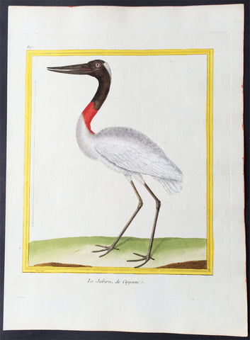
1775 Comte De Buffon Antique Imperial Ornithology Print American Jabiru, Stork - Rare Imperial edition
- Title : Le Jabiru, de Cayenne
- Size: 12in x 9in (305mm x 230mm)
- Condition: (A+) Fine Condition
- Date : 1775
- Ref #: 23505
Description:
This beautifully hand coloured original copper-plate engraved antique print was published in the 1775 Imperial quatro edtion of Comte de Buffons Histoire Naturelle, générale et particulière, avec la description du Cabinet du Roi (Natural History, General and Particular, with a Description of the King\'s Cabinet)
These prints are rare produced for a limited release of Histoire Naturelle with both the engraving and hand colouring done under the supervision of the French naturalist. Edme-Louis Daubenton and engraved by the famous French engraver Francois Nicolas Martinet.
A deluxe edition of Histoire Naturelle des Oiseaux (Birds) (1771–1786) was produced by the Imprimerie royale in 10 folio and quarto volumes, with 1008 engraved by Francois Nicolas Martinet
and hand-coloured plates, executed under Buffons personal supervision by Edme-Louis Daubenton, cousin and brother-in-law of Buffons principal collaborator.
Francois Nicolas Martinet was a French engraver and draughtsman. In 1756, he was working for the court of France as Graveur du Cabinet du Roi, under the auspices of the Menus Plaisirs du Roi, making engravings after drawings by others of such subjects as the May Ball at Versailles during the Carnival of 1763. In the same period, Martinet produced illustrations for plays or comic operas by such contemporaries as Marmontel, Voltaire and Philidor. Some of these he engraved himself, while others were drawn by him but engraved by his sister Thérèse Martinet (born c. 1731). He is best known for his engravings of birds for Comte de Buffon\'s, Histoire Naturelle Des Oiseaux published in Paris from 1770-86. In 1768, a comprehensive group of natural history studies drafted by Martinet, and engraved by Robert Bénard were included in the natural history volume of Diderot and Alembert’s Encyclopédie. Martinet also drew and engraved portraits, landscapes and genre scenes.
Edme-Louis Daubenton 1730 – 1785 was a French naturalist.
Daubenton was the cousin of another French naturalist, Louis Jean-Marie Daubenton. Georges-Louis Leclerc, the Comte de Buffon engaged Edme-Louis Daubenton to supervise the coloured illustrations for the monumental Histoire Naturelle (1749–89). The Planches enluminée started to appear in 1765 and finally counted 1,008 plates, all engraved by François-Nicolas Martinet (1731–1800), and all painted by hand. The Parisian publisher Panckoucke published a version without text between 1765 and 1783. More than 80 artists took part in the realization of the original paintings. 973 plates relate to birds; others illustrate especially butterflies but also other insects, corals, etc. The illustrations were not very successful, but they allow a rather good determination of the species illustrated, some of them now extinct. As Buffon did not follow the system of biological nomenclature developed by Carl von Linné in 1783, Pieter Boddaert (1730–1796) published a table of the correspondence of the names used with their Linnean binomial names.
General Definitions:
Paper thickness and quality: - Heavy and stable
Paper color : - off white
Age of map color: - Original
Colors used: - Blue, pink, red, green, yellow
General color appearance: - Authentic
Paper size: - 12in x 9in (305mm x 230mm)
Plate size: - 10in x 8in (255mm x 205mm)
Margins: - Min 1in (25mm)
Imperfections:
Margins: - None
Plate area: - None
Verso: - None
Background:
The Histoire Naturelle, générale et particulière, avec la description du Cabinet du Roi (Natural History, General and Particular, with a Description of the Kings Cabinet) is an encyclopaedic collection of 36 large (quarto) volumes written between 1749–1804 by the Comte de Buffon, and continued in eight more volumes after his death by his colleagues, led by Bernard Germain de Lacépède. The books cover what was known of the natural sciences at the time, including what would now be called material science, physics, chemistry and technology as well as the natural history of animals.
The Histoire Naturelle, générale et particulière, avec la description du Cabinet du Roi is the work that the Comte de Buffon (1707–1788) is remembered for. He worked on it for some 50 years, initially at Montbard in his office in the Tour Saint-Louis, then in his library at Petit Fontenet. 36 volumes came out between 1749 and 1789, followed by 8 more after his death, thanks to Bernard Germain de Lacépède. It includes all the knowledge available in his time on the natural sciences, a broad term that includes disciplines which today would be called material science, physics, chemistry and technology. Buffon notes the morphological similarities between men and apes, although he considered apes completely devoid of the ability to think, differentiating them sharply from human beings. Buffons attention to internal anatomy made him an early comparative anatomist. Lintérieur, dans les êtres vivants, est le fond du dessin de la nature, he wrote in his Quadrupèdes, the interior, in living things, is the foundation of natures design.
The Histoire Naturelle, which was meant to address the whole of natural history, actually covers only minerals, birds, and the quadrupeds among animals. It is accompanied by some discourses and a theory of the earth by way of introduction, and by supplements including an elegantly written account of the epochs of nature.
The Suppléments cover a wide range of topics; for example, in (Suppléments IV), there is a Discours sur le style (Discourse on Style) and an Essai darithmétique morale (essay on Moral Arithmetic).
Louis Jean-Marie Daubenton assisted Buffon on the quadrupeds; Philippe Guéneau de Montbeillard worked on the birds. They were joined, from 1767, by Barthélemy Faujas de Saint-Fond, the abbot Gabriel Bexon and Charles-Nicolas-Sigisbert Sonnini de Manoncourt. The whole descriptive and anatomical part of lHistoire des Quadrupèdes was the work of Daubenton and Jean-Claude Mertrud.
Buffon attached much importance to the illustrations; Jacques de Sève illustrated the quadrupeds and François-Nicolas Martinet illustrated the birds. Nearly 2000 plates adorn the work, representing animals with care given both to aesthetics and anatomical accuracy, with dreamlike and mythological settings.
On minerals, Buffon collaborated with André Thouin. Barthélemy Faujas de Saint-Fond and Louis Bernard Guyton de Morveau provided sources for the mineral volumes.
L Histoire Naturelle met immense success, almost as great as Encyclopédie by Diderot, which came out in the same period. The first three volumes of LHistoire Naturelle, générale et particulière, avec la description du cabinet du Roi were reprinted three times in six weeks.
The encyclopaedia appeared in 36 volumes :
3 volumes in 1749 : De la manière détudier lhistoire naturelle followed by Théorie de la Terre, Histoire Générale des animaux and Histoire Naturelle de lhomme
12 volumes on quadrupeds (1753 to 1767)
9 volumes on birds (1770 to 1783])
5 volumes on minerals (1783 to 1788), the last including Traité de laimant, the last work published by Buffon in his lifetime
7 volumes of supplements (1774 to 1789), including Époques de la nature (from 1778).
LHistoire Naturelle was initially printed at the Imprimerie royale in 36 volumes (1749–1789). In 1764 Buffon bought back the rights to his work. It was continued by Bernard Germain de Lacépède, who described the egg-laying quadrupeds, snakes, fishes and cetaceans in 8 volumes (1788–1804).
Buffon was assisted in the work by Jacques-François Artur (1708–1779), Gabriel Léopold Charles Amé Bexon (1748–1785), Louis Jean-Marie Daubenton (1716–1799), Edme-Louis Daubenton (1732–1786), Jacques de Sève (actif 1742–1788), Barthélemy Faujas de Saint-Fond (1741–1819), Philippe Guéneau de Montbeillard (1720–1785), Louis-Bernard Guyton-Morveau (1737–1816), Bernard Germain de Lacépède (1756–1825), François-Nicolas Martinet (1731–1800), the anatomist Jean-Claude Mertrud (1728–1802), Charles-Nicolas-Sigisbert Sonnini de Manoncourt (1751–1812), and André Thouin (1747–1823).
Each group is introduced with a general essay. This is followed by an article, sometimes of many pages, on each animal (or other item). The article on the wolf begins with the claim that it is one of the animals with a specially strong appetite for flesh; it asserts that the animal is naturally coarse and cowardly (grossier et poltron), but becoming crafty at need, and hardy by necessity, driven by hunger.[4] The language, as in this instance, is elegant and elaborate, even flowery and ornate.[5] Buffon was roundly criticised by his fellow academics for writing a purely popularizing work, empty and puffed up, with little real scientific value.
The species is named in Greek, Latin, Italian, Spanish, German, English, Swedish, and Polish. The zoological descriptions of the species by Gessner, Ray, Linnaeus, Klein and Buffon himself (Canis ex griseo flavescens. Lupus vulgaris. Buffon. Reg. animal. pag. 235) are cited.
The text is written as a continuous essay, without the sections on identification, distribution and behaviour that might have been expected from other natural histories. Parts concern human responses rather than the animal itself, as for example that the wolf likes human flesh, and the strongest wolves sometimes eat nothing else.[6] Measurements may be included; in the case of the wolf, 41 separate measurements are tabulated, in pre-revolutionary French feet and inches[a] starting with the Length of the whole body measured in a straight line from the end of the muzzle to the anus........3 feet. 7 inches. (1.2 m); the Length of the largest claws is given as 10 lines (2.2 cm).
The wolf is illustrated standing in farmland, and as a complete skeleton standing on a stone plinth in a landscape. The account of the species occupies 32 pages including illustrations.
The original edition of the Histoire Naturelle by Buffon comprised 36 volumes in quarto, divided into the following series: Histoire de la Terre et de lHomme, Quadrupèdes, Oiseaux, Minéraux, Suppléments. Buffon edited 35 volumes in his lifetime. Soon after his death, the fifth and final volume of lHistoire des minéraux appeared in 1788 at the Imprimerie des Bâtiments du Roi. The seventh and final volume of Suppléments by Buffon was published posthumously in 1789 through Lacépèdes hands. Lacépède continued the part of the Histoire Naturelle which dealt with animals. A few months before Buffons death, en 1788, Lacépède published, as a continuation, the first volume of his Histoire des Reptiles, on egg-laying quadrupeds. The next year, he wrote a second volume on snakes, published during the French Revolution. Between 1798 and 1803, he brought out the volume Histoire des Poissons. Lacépède made use of the notes and collections left by Philibert Commerson (1727–1773). He wrote Histoire des Cétacés which was printed in 1804. At that point, the Histoire Naturelle, by Buffon and Lacépède, thus contained 44 quarto volumes forming the definitive edition.
Another edition in quarto format was printed by the Imprimerie royale in 36 volumes (1774–1804). It consisted of 28 volumes par Buffon, and 8 volumes by Lacépède. The part containing anatomical articles by Louis Jean-Marie Daubenton was dropped. The supplements were merged into the relevant articles in the main volumes.
The Imprimerie royale also published two editions of the Histoire Naturelle in duodecimo format (1752–1805), occupying 90 or 71 volumes, depending on whether or not they included the part on anatomy. In this print format, the original work by Buffon occupied 73 volumes with the part on anatomy, or 54 volumes without the part on anatomy. The continuation by Lacépède took up 17 duodecimo volumes.
A de luxe edition of Histoire Naturelle des Oiseaux (Birds) (1771–1786) was produced by the Imprimerie royale in 10 folio and quarto volumes, with 1008 engraved and hand-coloured plates, executed under Buffons personal supervision by Edme-Louis Daubenton, cousin and brother-in-law of Buffons principal collaborator.
The original edition was arranged as follows:
Natural history, and description of the kings cabinet of curiosities
Volume I : Premier Discours - De la manière détudier et de traiter lhistoire naturelle, Second Discours - Histoire et théorie de la Terre, Preuves de la théorie de la Terre, 1749
Volume II : Histoire générale des Animaux, Histoire Naturelle de lHomme, 1749
Volume III : Description du cabinet du Roi, Histoire Naturelle de lHomme, 1749
Quadrupèdes (Quadrupeds)
Volume IV (Quadrupèdes I) : Discours sur la nature des Animaux, Les Animaux domestiques, 1753
Volume V (Quadrupèdes II) : 1755
Volume VI (Quadrupèdes III) : Les Animaux sauvages, 1756
Volume VII (Quadrupèdes IV) : Les Animaux carnassiers, 1758
Volume VIII (Quadrupèdes V) : 1760
Volume IX (Quadrupèdes VI) : 1761
Volume X (Quadrupèdes VII) : 1763
Volume XI (Quadrupèdes VIII) : 1764
Volume XII (Quadrupèdes IX) : 1764
Volume XIII (Quadrupèdes X) : 1765
Volume XIV (Quadrupèdes XI) : Nomenclature des Singes, De la dégénération des Animaux, 1766
Volume XV (Quadrupèdes XII) : 1767
Histoire Naturelle des Oiseaux (Birds) (1770–1783)
Volume XVI (Oiseaux I) : 1770
Volume XVII (Oiseaux II) : 1771
Volume XVIII (Oiseaux III) : 1774
Volume XIX (Oiseaux IV) : 1778
Volume XX (Oiseaux V) : 1778
Volume XXI (Oiseaux VI) : 1779
Volume XXII (Oiseaux VII) : 1780
Volume XXIII (Oiseaux VIII) : 1781
Volume XXIV (Oiseaux IX) : 1783
Histoire Naturelle des Minéraux (Minerals) (1783–1788)
Volume XXV (Minéraux I) : 1783
Volume XXVI (Minéraux II) : 1783
Volume XXVII (Minéraux III) : 1785
Volume XXVIII (Minéraux IV) : 1786
Volume XXIX (Minéraux V) : Traité de lAimant et de ses usages, 1788
Suppléments à lHistoire Naturelle, générale et particulière (Supplements) (1774–1789)
Volume XXX (Suppléments I) : Servant de suite à la Théorie de la Terre, et dintroduction à lHistoire des Minéraux, 1774
Volume XXXI (Suppléments II) : Servant de suite à la Théorie de la Terre, et de préliminaire à lHistoire des Végétaux - Parties Expérimentale & Hypothétique, 1775
Volume XXXII (Suppléments III) : Servant de suite à lHistoire des Animaux quadrupèdes, 1776
Volume XXXIII (Suppléments IV) : Servant de suite à lHistoire Naturelle de lHomme, 1777
Volume XXXIV (Suppléments V) : Des Époques de la nature, 1779
Volume XXXV (Suppléments VI) : Servant de suite à lHistoire des Animaux quadrupèdes, 1782
Volume XXXVI (Suppléments VII) : Servant de suite à lHistoire des Animaux quadrupèdes, 1789
Histoire Naturelle des Quadrupèdes ovipares et des Serpents (Egg-laying Quadrupeds and Snakes) (1788–1789)
The Gecko, 1788
Volume XXXVII (Reptiles I) : Histoire générale et particulière des Quadrupèdes ovipares, 1788
Volume XXXVIII (Reptiles II) : Histoire des Serpents, 1789
Histoire Naturelle des Poissons (Fish) (1798–1803)
Volume XXXIX (Poissons I) : 1798
Volume XXXX (Poissons II) : 1800
Volume XXXXI (Poissons III) : 1802
Volume XXXXII (Poissons IV) : 1802
Volume XXXXIII (Poissons V) : 1803
Histoire Naturelle des Cétacés (Cetaceans) (1804)
Volume XXXXIV (Cétacés) : 1804
1775 Comte De Buffon Antique Imperial Ornithology Print Grey-Necked Wood Rail - Rare Imperial edition
- Title : Rale, de Cayenne
- Size: 12in x 9in (305mm x 230mm)
- Condition: (A+) Fine Condition
- Date : 1775
- Ref #: 23507
Description:
This beautifully hand coloured original copper-plate engraved antique print was published in the 1775 Imperial quatro edtion of Comte de Buffons Histoire Naturelle, générale et particulière, avec la description du Cabinet du Roi (Natural History, General and Particular, with a Description of the King\'s Cabinet)
These prints are rare produced for a limited release of Histoire Naturelle with both the engraving and hand colouring done under the supervision of the French naturalist. Edme-Louis Daubenton and engraved by the famous French engraver Francois Nicolas Martinet.
A deluxe edition of Histoire Naturelle des Oiseaux (Birds) (1771–1786) was produced by the Imprimerie royale in 10 folio and quarto volumes, with 1008 engraved by Francois Nicolas Martinet
and hand-coloured plates, executed under Buffons personal supervision by Edme-Louis Daubenton, cousin and brother-in-law of Buffons principal collaborator.
Francois Nicolas Martinet was a French engraver and draughtsman. In 1756, he was working for the court of France as Graveur du Cabinet du Roi, under the auspices of the Menus Plaisirs du Roi, making engravings after drawings by others of such subjects as the May Ball at Versailles during the Carnival of 1763. In the same period, Martinet produced illustrations for plays or comic operas by such contemporaries as Marmontel, Voltaire and Philidor. Some of these he engraved himself, while others were drawn by him but engraved by his sister Thérèse Martinet (born c. 1731). He is best known for his engravings of birds for Comte de Buffon\'s, Histoire Naturelle Des Oiseaux published in Paris from 1770-86. In 1768, a comprehensive group of natural history studies drafted by Martinet, and engraved by Robert Bénard were included in the natural history volume of Diderot and Alembert’s Encyclopédie. Martinet also drew and engraved portraits, landscapes and genre scenes.
Edme-Louis Daubenton 1730 – 1785 was a French naturalist.
Daubenton was the cousin of another French naturalist, Louis Jean-Marie Daubenton. Georges-Louis Leclerc, the Comte de Buffon engaged Edme-Louis Daubenton to supervise the coloured illustrations for the monumental Histoire Naturelle (1749–89). The Planches enluminée started to appear in 1765 and finally counted 1,008 plates, all engraved by François-Nicolas Martinet (1731–1800), and all painted by hand. The Parisian publisher Panckoucke published a version without text between 1765 and 1783. More than 80 artists took part in the realization of the original paintings. 973 plates relate to birds; others illustrate especially butterflies but also other insects, corals, etc. The illustrations were not very successful, but they allow a rather good determination of the species illustrated, some of them now extinct. As Buffon did not follow the system of biological nomenclature developed by Carl von Linné in 1783, Pieter Boddaert (1730–1796) published a table of the correspondence of the names used with their Linnean binomial names.
General Definitions:
Paper thickness and quality: - Heavy and stable
Paper color : - off white
Age of map color: - Original
Colors used: - Blue, pink, red, green, yellow
General color appearance: - Authentic
Paper size: - 12in x 9in (305mm x 230mm)
Plate size: - 10in x 8in (255mm x 205mm)
Margins: - Min 1in (25mm)
Imperfections:
Margins: - None
Plate area: - None
Verso: - None
Background:
The Histoire Naturelle, générale et particulière, avec la description du Cabinet du Roi (Natural History, General and Particular, with a Description of the Kings Cabinet) is an encyclopaedic collection of 36 large (quarto) volumes written between 1749–1804 by the Comte de Buffon, and continued in eight more volumes after his death by his colleagues, led by Bernard Germain de Lacépède. The books cover what was known of the natural sciences at the time, including what would now be called material science, physics, chemistry and technology as well as the natural history of animals.
The Histoire Naturelle, générale et particulière, avec la description du Cabinet du Roi is the work that the Comte de Buffon (1707–1788) is remembered for. He worked on it for some 50 years, initially at Montbard in his office in the Tour Saint-Louis, then in his library at Petit Fontenet. 36 volumes came out between 1749 and 1789, followed by 8 more after his death, thanks to Bernard Germain de Lacépède. It includes all the knowledge available in his time on the natural sciences, a broad term that includes disciplines which today would be called material science, physics, chemistry and technology. Buffon notes the morphological similarities between men and apes, although he considered apes completely devoid of the ability to think, differentiating them sharply from human beings. Buffons attention to internal anatomy made him an early comparative anatomist. Lintérieur, dans les êtres vivants, est le fond du dessin de la nature, he wrote in his Quadrupèdes, the interior, in living things, is the foundation of natures design.
The Histoire Naturelle, which was meant to address the whole of natural history, actually covers only minerals, birds, and the quadrupeds among animals. It is accompanied by some discourses and a theory of the earth by way of introduction, and by supplements including an elegantly written account of the epochs of nature.
The Suppléments cover a wide range of topics; for example, in (Suppléments IV), there is a Discours sur le style (Discourse on Style) and an Essai darithmétique morale (essay on Moral Arithmetic).
Louis Jean-Marie Daubenton assisted Buffon on the quadrupeds; Philippe Guéneau de Montbeillard worked on the birds. They were joined, from 1767, by Barthélemy Faujas de Saint-Fond, the abbot Gabriel Bexon and Charles-Nicolas-Sigisbert Sonnini de Manoncourt. The whole descriptive and anatomical part of lHistoire des Quadrupèdes was the work of Daubenton and Jean-Claude Mertrud.
Buffon attached much importance to the illustrations; Jacques de Sève illustrated the quadrupeds and François-Nicolas Martinet illustrated the birds. Nearly 2000 plates adorn the work, representing animals with care given both to aesthetics and anatomical accuracy, with dreamlike and mythological settings.
On minerals, Buffon collaborated with André Thouin. Barthélemy Faujas de Saint-Fond and Louis Bernard Guyton de Morveau provided sources for the mineral volumes.
L Histoire Naturelle met immense success, almost as great as Encyclopédie by Diderot, which came out in the same period. The first three volumes of LHistoire Naturelle, générale et particulière, avec la description du cabinet du Roi were reprinted three times in six weeks.
The encyclopaedia appeared in 36 volumes :
3 volumes in 1749 : De la manière détudier lhistoire naturelle followed by Théorie de la Terre, Histoire Générale des animaux and Histoire Naturelle de lhomme
12 volumes on quadrupeds (1753 to 1767)
9 volumes on birds (1770 to 1783])
5 volumes on minerals (1783 to 1788), the last including Traité de laimant, the last work published by Buffon in his lifetime
7 volumes of supplements (1774 to 1789), including Époques de la nature (from 1778).
LHistoire Naturelle was initially printed at the Imprimerie royale in 36 volumes (1749–1789). In 1764 Buffon bought back the rights to his work. It was continued by Bernard Germain de Lacépède, who described the egg-laying quadrupeds, snakes, fishes and cetaceans in 8 volumes (1788–1804).
Buffon was assisted in the work by Jacques-François Artur (1708–1779), Gabriel Léopold Charles Amé Bexon (1748–1785), Louis Jean-Marie Daubenton (1716–1799), Edme-Louis Daubenton (1732–1786), Jacques de Sève (actif 1742–1788), Barthélemy Faujas de Saint-Fond (1741–1819), Philippe Guéneau de Montbeillard (1720–1785), Louis-Bernard Guyton-Morveau (1737–1816), Bernard Germain de Lacépède (1756–1825), François-Nicolas Martinet (1731–1800), the anatomist Jean-Claude Mertrud (1728–1802), Charles-Nicolas-Sigisbert Sonnini de Manoncourt (1751–1812), and André Thouin (1747–1823).
Each group is introduced with a general essay. This is followed by an article, sometimes of many pages, on each animal (or other item). The article on the wolf begins with the claim that it is one of the animals with a specially strong appetite for flesh; it asserts that the animal is naturally coarse and cowardly (grossier et poltron), but becoming crafty at need, and hardy by necessity, driven by hunger.[4] The language, as in this instance, is elegant and elaborate, even flowery and ornate.[5] Buffon was roundly criticised by his fellow academics for writing a purely popularizing work, empty and puffed up, with little real scientific value.
The species is named in Greek, Latin, Italian, Spanish, German, English, Swedish, and Polish. The zoological descriptions of the species by Gessner, Ray, Linnaeus, Klein and Buffon himself (Canis ex griseo flavescens. Lupus vulgaris. Buffon. Reg. animal. pag. 235) are cited.
The text is written as a continuous essay, without the sections on identification, distribution and behaviour that might have been expected from other natural histories. Parts concern human responses rather than the animal itself, as for example that the wolf likes human flesh, and the strongest wolves sometimes eat nothing else.[6] Measurements may be included; in the case of the wolf, 41 separate measurements are tabulated, in pre-revolutionary French feet and inches[a] starting with the Length of the whole body measured in a straight line from the end of the muzzle to the anus........3 feet. 7 inches. (1.2 m); the Length of the largest claws is given as 10 lines (2.2 cm).
The wolf is illustrated standing in farmland, and as a complete skeleton standing on a stone plinth in a landscape. The account of the species occupies 32 pages including illustrations.
The original edition of the Histoire Naturelle by Buffon comprised 36 volumes in quarto, divided into the following series: Histoire de la Terre et de lHomme, Quadrupèdes, Oiseaux, Minéraux, Suppléments. Buffon edited 35 volumes in his lifetime. Soon after his death, the fifth and final volume of lHistoire des minéraux appeared in 1788 at the Imprimerie des Bâtiments du Roi. The seventh and final volume of Suppléments by Buffon was published posthumously in 1789 through Lacépèdes hands. Lacépède continued the part of the Histoire Naturelle which dealt with animals. A few months before Buffons death, en 1788, Lacépède published, as a continuation, the first volume of his Histoire des Reptiles, on egg-laying quadrupeds. The next year, he wrote a second volume on snakes, published during the French Revolution. Between 1798 and 1803, he brought out the volume Histoire des Poissons. Lacépède made use of the notes and collections left by Philibert Commerson (1727–1773). He wrote Histoire des Cétacés which was printed in 1804. At that point, the Histoire Naturelle, by Buffon and Lacépède, thus contained 44 quarto volumes forming the definitive edition.
Another edition in quarto format was printed by the Imprimerie royale in 36 volumes (1774–1804). It consisted of 28 volumes par Buffon, and 8 volumes by Lacépède. The part containing anatomical articles by Louis Jean-Marie Daubenton was dropped. The supplements were merged into the relevant articles in the main volumes.
The Imprimerie royale also published two editions of the Histoire Naturelle in duodecimo format (1752–1805), occupying 90 or 71 volumes, depending on whether or not they included the part on anatomy. In this print format, the original work by Buffon occupied 73 volumes with the part on anatomy, or 54 volumes without the part on anatomy. The continuation by Lacépède took up 17 duodecimo volumes.
A de luxe edition of Histoire Naturelle des Oiseaux (Birds) (1771–1786) was produced by the Imprimerie royale in 10 folio and quarto volumes, with 1008 engraved and hand-coloured plates, executed under Buffons personal supervision by Edme-Louis Daubenton, cousin and brother-in-law of Buffons principal collaborator.
The original edition was arranged as follows:
Natural history, and description of the kings cabinet of curiosities
Volume I : Premier Discours - De la manière détudier et de traiter lhistoire naturelle, Second Discours - Histoire et théorie de la Terre, Preuves de la théorie de la Terre, 1749
Volume II : Histoire générale des Animaux, Histoire Naturelle de lHomme, 1749
Volume III : Description du cabinet du Roi, Histoire Naturelle de lHomme, 1749
Quadrupèdes (Quadrupeds)
Volume IV (Quadrupèdes I) : Discours sur la nature des Animaux, Les Animaux domestiques, 1753
Volume V (Quadrupèdes II) : 1755
Volume VI (Quadrupèdes III) : Les Animaux sauvages, 1756
Volume VII (Quadrupèdes IV) : Les Animaux carnassiers, 1758
Volume VIII (Quadrupèdes V) : 1760
Volume IX (Quadrupèdes VI) : 1761
Volume X (Quadrupèdes VII) : 1763
Volume XI (Quadrupèdes VIII) : 1764
Volume XII (Quadrupèdes IX) : 1764
Volume XIII (Quadrupèdes X) : 1765
Volume XIV (Quadrupèdes XI) : Nomenclature des Singes, De la dégénération des Animaux, 1766
Volume XV (Quadrupèdes XII) : 1767
Histoire Naturelle des Oiseaux (Birds) (1770–1783)
Volume XVI (Oiseaux I) : 1770
Volume XVII (Oiseaux II) : 1771
Volume XVIII (Oiseaux III) : 1774
Volume XIX (Oiseaux IV) : 1778
Volume XX (Oiseaux V) : 1778
Volume XXI (Oiseaux VI) : 1779
Volume XXII (Oiseaux VII) : 1780
Volume XXIII (Oiseaux VIII) : 1781
Volume XXIV (Oiseaux IX) : 1783
Histoire Naturelle des Minéraux (Minerals) (1783–1788)
Volume XXV (Minéraux I) : 1783
Volume XXVI (Minéraux II) : 1783
Volume XXVII (Minéraux III) : 1785
Volume XXVIII (Minéraux IV) : 1786
Volume XXIX (Minéraux V) : Traité de lAimant et de ses usages, 1788
Suppléments à lHistoire Naturelle, générale et particulière (Supplements) (1774–1789)
Volume XXX (Suppléments I) : Servant de suite à la Théorie de la Terre, et dintroduction à lHistoire des Minéraux, 1774
Volume XXXI (Suppléments II) : Servant de suite à la Théorie de la Terre, et de préliminaire à lHistoire des Végétaux - Parties Expérimentale & Hypothétique, 1775
Volume XXXII (Suppléments III) : Servant de suite à lHistoire des Animaux quadrupèdes, 1776
Volume XXXIII (Suppléments IV) : Servant de suite à lHistoire Naturelle de lHomme, 1777
Volume XXXIV (Suppléments V) : Des Époques de la nature, 1779
Volume XXXV (Suppléments VI) : Servant de suite à lHistoire des Animaux quadrupèdes, 1782
Volume XXXVI (Suppléments VII) : Servant de suite à lHistoire des Animaux quadrupèdes, 1789
Histoire Naturelle des Quadrupèdes ovipares et des Serpents (Egg-laying Quadrupeds and Snakes) (1788–1789)
The Gecko, 1788
Volume XXXVII (Reptiles I) : Histoire générale et particulière des Quadrupèdes ovipares, 1788
Volume XXXVIII (Reptiles II) : Histoire des Serpents, 1789
Histoire Naturelle des Poissons (Fish) (1798–1803)
Volume XXXIX (Poissons I) : 1798
Volume XXXX (Poissons II) : 1800
Volume XXXXI (Poissons III) : 1802
Volume XXXXII (Poissons IV) : 1802
Volume XXXXIII (Poissons V) : 1803
Histoire Naturelle des Cétacés (Cetaceans) (1804)
Volume XXXXIV (Cétacés) : 1804
1775 Comte De Buffon Antique Imperial Ornithology Print of a European Bee Eater - Rare Imperial edition
- Title : Le Guepier
- Size: 12in x 9in (305mm x 230mm)
- Condition: (A+) Fine Condition
- Date : 1775
- Ref #: 23511
Description:
This beautifully hand coloured original copper-plate engraved antique print was published in the 1775 Imperial quatro edtion of Comte de Buffons Histoire Naturelle, générale et particulière, avec la description du Cabinet du Roi (Natural History, General and Particular, with a Description of the King\'s Cabinet)
These prints are rare produced for a limited release of Histoire Naturelle with both the engraving and hand colouring done under the supervision of the French naturalist. Edme-Louis Daubenton and engraved by the famous French engraver Francois Nicolas Martinet.
A deluxe edition of Histoire Naturelle des Oiseaux (Birds) (1771–1786) was produced by the Imprimerie royale in 10 folio and quarto volumes, with 1008 engraved by Francois Nicolas Martinet
and hand-coloured plates, executed under Buffons personal supervision by Edme-Louis Daubenton, cousin and brother-in-law of Buffons principal collaborator.
Francois Nicolas Martinet was a French engraver and draughtsman. In 1756, he was working for the court of France as Graveur du Cabinet du Roi, under the auspices of the Menus Plaisirs du Roi, making engravings after drawings by others of such subjects as the May Ball at Versailles during the Carnival of 1763. In the same period, Martinet produced illustrations for plays or comic operas by such contemporaries as Marmontel, Voltaire and Philidor. Some of these he engraved himself, while others were drawn by him but engraved by his sister Thérèse Martinet (born c. 1731). He is best known for his engravings of birds for Comte de Buffon\'s, Histoire Naturelle Des Oiseaux published in Paris from 1770-86. In 1768, a comprehensive group of natural history studies drafted by Martinet, and engraved by Robert Bénard were included in the natural history volume of Diderot and Alembert’s Encyclopédie. Martinet also drew and engraved portraits, landscapes and genre scenes.
Edme-Louis Daubenton 1730 – 1785 was a French naturalist.
Daubenton was the cousin of another French naturalist, Louis Jean-Marie Daubenton. Georges-Louis Leclerc, the Comte de Buffon engaged Edme-Louis Daubenton to supervise the coloured illustrations for the monumental Histoire Naturelle (1749–89). The Planches enluminée started to appear in 1765 and finally counted 1,008 plates, all engraved by François-Nicolas Martinet (1731–1800), and all painted by hand. The Parisian publisher Panckoucke published a version without text between 1765 and 1783. More than 80 artists took part in the realization of the original paintings. 973 plates relate to birds; others illustrate especially butterflies but also other insects, corals, etc. The illustrations were not very successful, but they allow a rather good determination of the species illustrated, some of them now extinct. As Buffon did not follow the system of biological nomenclature developed by Carl von Linné in 1783, Pieter Boddaert (1730–1796) published a table of the correspondence of the names used with their Linnean binomial names.
General Definitions:
Paper thickness and quality: - Heavy and stable
Paper color : - off white
Age of map color: - Original
Colors used: - Blue, pink, red, green, yellow
General color appearance: - Authentic
Paper size: - 12in x 9in (305mm x 230mm)
Plate size: - 10in x 8in (255mm x 205mm)
Margins: - Min 1in (25mm)
Imperfections:
Margins: - None
Plate area: - None
Verso: - None
Background:
The Histoire Naturelle, générale et particulière, avec la description du Cabinet du Roi (Natural History, General and Particular, with a Description of the Kings Cabinet) is an encyclopaedic collection of 36 large (quarto) volumes written between 1749–1804 by the Comte de Buffon, and continued in eight more volumes after his death by his colleagues, led by Bernard Germain de Lacépède. The books cover what was known of the natural sciences at the time, including what would now be called material science, physics, chemistry and technology as well as the natural history of animals.
The Histoire Naturelle, générale et particulière, avec la description du Cabinet du Roi is the work that the Comte de Buffon (1707–1788) is remembered for. He worked on it for some 50 years, initially at Montbard in his office in the Tour Saint-Louis, then in his library at Petit Fontenet. 36 volumes came out between 1749 and 1789, followed by 8 more after his death, thanks to Bernard Germain de Lacépède. It includes all the knowledge available in his time on the natural sciences, a broad term that includes disciplines which today would be called material science, physics, chemistry and technology. Buffon notes the morphological similarities between men and apes, although he considered apes completely devoid of the ability to think, differentiating them sharply from human beings. Buffons attention to internal anatomy made him an early comparative anatomist. Lintérieur, dans les êtres vivants, est le fond du dessin de la nature, he wrote in his Quadrupèdes, the interior, in living things, is the foundation of natures design.
The Histoire Naturelle, which was meant to address the whole of natural history, actually covers only minerals, birds, and the quadrupeds among animals. It is accompanied by some discourses and a theory of the earth by way of introduction, and by supplements including an elegantly written account of the epochs of nature.
The Suppléments cover a wide range of topics; for example, in (Suppléments IV), there is a Discours sur le style (Discourse on Style) and an Essai darithmétique morale (essay on Moral Arithmetic).
Louis Jean-Marie Daubenton assisted Buffon on the quadrupeds; Philippe Guéneau de Montbeillard worked on the birds. They were joined, from 1767, by Barthélemy Faujas de Saint-Fond, the abbot Gabriel Bexon and Charles-Nicolas-Sigisbert Sonnini de Manoncourt. The whole descriptive and anatomical part of lHistoire des Quadrupèdes was the work of Daubenton and Jean-Claude Mertrud.
Buffon attached much importance to the illustrations; Jacques de Sève illustrated the quadrupeds and François-Nicolas Martinet illustrated the birds. Nearly 2000 plates adorn the work, representing animals with care given both to aesthetics and anatomical accuracy, with dreamlike and mythological settings.
On minerals, Buffon collaborated with André Thouin. Barthélemy Faujas de Saint-Fond and Louis Bernard Guyton de Morveau provided sources for the mineral volumes.
L Histoire Naturelle met immense success, almost as great as Encyclopédie by Diderot, which came out in the same period. The first three volumes of LHistoire Naturelle, générale et particulière, avec la description du cabinet du Roi were reprinted three times in six weeks.
The encyclopaedia appeared in 36 volumes :
3 volumes in 1749 : De la manière détudier lhistoire naturelle followed by Théorie de la Terre, Histoire Générale des animaux and Histoire Naturelle de lhomme
12 volumes on quadrupeds (1753 to 1767)
9 volumes on birds (1770 to 1783])
5 volumes on minerals (1783 to 1788), the last including Traité de laimant, the last work published by Buffon in his lifetime
7 volumes of supplements (1774 to 1789), including Époques de la nature (from 1778).
LHistoire Naturelle was initially printed at the Imprimerie royale in 36 volumes (1749–1789). In 1764 Buffon bought back the rights to his work. It was continued by Bernard Germain de Lacépède, who described the egg-laying quadrupeds, snakes, fishes and cetaceans in 8 volumes (1788–1804).
Buffon was assisted in the work by Jacques-François Artur (1708–1779), Gabriel Léopold Charles Amé Bexon (1748–1785), Louis Jean-Marie Daubenton (1716–1799), Edme-Louis Daubenton (1732–1786), Jacques de Sève (actif 1742–1788), Barthélemy Faujas de Saint-Fond (1741–1819), Philippe Guéneau de Montbeillard (1720–1785), Louis-Bernard Guyton-Morveau (1737–1816), Bernard Germain de Lacépède (1756–1825), François-Nicolas Martinet (1731–1800), the anatomist Jean-Claude Mertrud (1728–1802), Charles-Nicolas-Sigisbert Sonnini de Manoncourt (1751–1812), and André Thouin (1747–1823).
Each group is introduced with a general essay. This is followed by an article, sometimes of many pages, on each animal (or other item). The article on the wolf begins with the claim that it is one of the animals with a specially strong appetite for flesh; it asserts that the animal is naturally coarse and cowardly (grossier et poltron), but becoming crafty at need, and hardy by necessity, driven by hunger.[4] The language, as in this instance, is elegant and elaborate, even flowery and ornate.[5] Buffon was roundly criticised by his fellow academics for writing a purely popularizing work, empty and puffed up, with little real scientific value.
The species is named in Greek, Latin, Italian, Spanish, German, English, Swedish, and Polish. The zoological descriptions of the species by Gessner, Ray, Linnaeus, Klein and Buffon himself (Canis ex griseo flavescens. Lupus vulgaris. Buffon. Reg. animal. pag. 235) are cited.
The text is written as a continuous essay, without the sections on identification, distribution and behaviour that might have been expected from other natural histories. Parts concern human responses rather than the animal itself, as for example that the wolf likes human flesh, and the strongest wolves sometimes eat nothing else.[6] Measurements may be included; in the case of the wolf, 41 separate measurements are tabulated, in pre-revolutionary French feet and inches[a] starting with the Length of the whole body measured in a straight line from the end of the muzzle to the anus........3 feet. 7 inches. (1.2 m); the Length of the largest claws is given as 10 lines (2.2 cm).
The wolf is illustrated standing in farmland, and as a complete skeleton standing on a stone plinth in a landscape. The account of the species occupies 32 pages including illustrations.
The original edition of the Histoire Naturelle by Buffon comprised 36 volumes in quarto, divided into the following series: Histoire de la Terre et de lHomme, Quadrupèdes, Oiseaux, Minéraux, Suppléments. Buffon edited 35 volumes in his lifetime. Soon after his death, the fifth and final volume of lHistoire des minéraux appeared in 1788 at the Imprimerie des Bâtiments du Roi. The seventh and final volume of Suppléments by Buffon was published posthumously in 1789 through Lacépèdes hands. Lacépède continued the part of the Histoire Naturelle which dealt with animals. A few months before Buffons death, en 1788, Lacépède published, as a continuation, the first volume of his Histoire des Reptiles, on egg-laying quadrupeds. The next year, he wrote a second volume on snakes, published during the French Revolution. Between 1798 and 1803, he brought out the volume Histoire des Poissons. Lacépède made use of the notes and collections left by Philibert Commerson (1727–1773). He wrote Histoire des Cétacés which was printed in 1804. At that point, the Histoire Naturelle, by Buffon and Lacépède, thus contained 44 quarto volumes forming the definitive edition.
Another edition in quarto format was printed by the Imprimerie royale in 36 volumes (1774–1804). It consisted of 28 volumes par Buffon, and 8 volumes by Lacépède. The part containing anatomical articles by Louis Jean-Marie Daubenton was dropped. The supplements were merged into the relevant articles in the main volumes.
The Imprimerie royale also published two editions of the Histoire Naturelle in duodecimo format (1752–1805), occupying 90 or 71 volumes, depending on whether or not they included the part on anatomy. In this print format, the original work by Buffon occupied 73 volumes with the part on anatomy, or 54 volumes without the part on anatomy. The continuation by Lacépède took up 17 duodecimo volumes.
A de luxe edition of Histoire Naturelle des Oiseaux (Birds) (1771–1786) was produced by the Imprimerie royale in 10 folio and quarto volumes, with 1008 engraved and hand-coloured plates, executed under Buffons personal supervision by Edme-Louis Daubenton, cousin and brother-in-law of Buffons principal collaborator.
The original edition was arranged as follows:
Natural history, and description of the kings cabinet of curiosities
Volume I : Premier Discours - De la manière détudier et de traiter lhistoire naturelle, Second Discours - Histoire et théorie de la Terre, Preuves de la théorie de la Terre, 1749
Volume II : Histoire générale des Animaux, Histoire Naturelle de lHomme, 1749
Volume III : Description du cabinet du Roi, Histoire Naturelle de lHomme, 1749
Quadrupèdes (Quadrupeds)
Volume IV (Quadrupèdes I) : Discours sur la nature des Animaux, Les Animaux domestiques, 1753
Volume V (Quadrupèdes II) : 1755
Volume VI (Quadrupèdes III) : Les Animaux sauvages, 1756
Volume VII (Quadrupèdes IV) : Les Animaux carnassiers, 1758
Volume VIII (Quadrupèdes V) : 1760
Volume IX (Quadrupèdes VI) : 1761
Volume X (Quadrupèdes VII) : 1763
Volume XI (Quadrupèdes VIII) : 1764
Volume XII (Quadrupèdes IX) : 1764
Volume XIII (Quadrupèdes X) : 1765
Volume XIV (Quadrupèdes XI) : Nomenclature des Singes, De la dégénération des Animaux, 1766
Volume XV (Quadrupèdes XII) : 1767
Histoire Naturelle des Oiseaux (Birds) (1770–1783)
Volume XVI (Oiseaux I) : 1770
Volume XVII (Oiseaux II) : 1771
Volume XVIII (Oiseaux III) : 1774
Volume XIX (Oiseaux IV) : 1778
Volume XX (Oiseaux V) : 1778
Volume XXI (Oiseaux VI) : 1779
Volume XXII (Oiseaux VII) : 1780
Volume XXIII (Oiseaux VIII) : 1781
Volume XXIV (Oiseaux IX) : 1783
Histoire Naturelle des Minéraux (Minerals) (1783–1788)
Volume XXV (Minéraux I) : 1783
Volume XXVI (Minéraux II) : 1783
Volume XXVII (Minéraux III) : 1785
Volume XXVIII (Minéraux IV) : 1786
Volume XXIX (Minéraux V) : Traité de lAimant et de ses usages, 1788
Suppléments à lHistoire Naturelle, générale et particulière (Supplements) (1774–1789)
Volume XXX (Suppléments I) : Servant de suite à la Théorie de la Terre, et dintroduction à lHistoire des Minéraux, 1774
Volume XXXI (Suppléments II) : Servant de suite à la Théorie de la Terre, et de préliminaire à lHistoire des Végétaux - Parties Expérimentale & Hypothétique, 1775
Volume XXXII (Suppléments III) : Servant de suite à lHistoire des Animaux quadrupèdes, 1776
Volume XXXIII (Suppléments IV) : Servant de suite à lHistoire Naturelle de lHomme, 1777
Volume XXXIV (Suppléments V) : Des Époques de la nature, 1779
Volume XXXV (Suppléments VI) : Servant de suite à lHistoire des Animaux quadrupèdes, 1782
Volume XXXVI (Suppléments VII) : Servant de suite à lHistoire des Animaux quadrupèdes, 1789
Histoire Naturelle des Quadrupèdes ovipares et des Serpents (Egg-laying Quadrupeds and Snakes) (1788–1789)
The Gecko, 1788
Volume XXXVII (Reptiles I) : Histoire générale et particulière des Quadrupèdes ovipares, 1788
Volume XXXVIII (Reptiles II) : Histoire des Serpents, 1789
Histoire Naturelle des Poissons (Fish) (1798–1803)
Volume XXXIX (Poissons I) : 1798
Volume XXXX (Poissons II) : 1800
Volume XXXXI (Poissons III) : 1802
Volume XXXXII (Poissons IV) : 1802
Volume XXXXIII (Poissons V) : 1803
Histoire Naturelle des Cétacés (Cetaceans) (1804)
Volume XXXXIV (Cétacés) : 1804
1775 Comte De Buffon Antique Imperial Ornithology Print The Jamaican Woodpecker - Rare Imperial edition
- Title : Pic varie Femelle, de la Jamaique
- Size: 12in x 9in (305mm x 230mm)
- Condition: (A+) Fine Condition
- Date : 1775
- Ref #: 23506
Description:
This beautifully hand coloured original copper-plate engraved antique print was published in the 1775 Imperial quatro edtion of Comte de Buffons Histoire Naturelle, générale et particulière, avec la description du Cabinet du Roi (Natural History, General and Particular, with a Description of the King\'s Cabinet)
These prints are rare produced for a limited release of Histoire Naturelle with both the engraving and hand colouring done under the supervision of the French naturalist. Edme-Louis Daubenton and engraved by the famous French engraver Francois Nicolas Martinet.
A deluxe edition of Histoire Naturelle des Oiseaux (Birds) (1771–1786) was produced by the Imprimerie royale in 10 folio and quarto volumes, with 1008 engraved by Francois Nicolas Martinet
and hand-coloured plates, executed under Buffons personal supervision by Edme-Louis Daubenton, cousin and brother-in-law of Buffons principal collaborator.
Francois Nicolas Martinet was a French engraver and draughtsman. In 1756, he was working for the court of France as Graveur du Cabinet du Roi, under the auspices of the Menus Plaisirs du Roi, making engravings after drawings by others of such subjects as the May Ball at Versailles during the Carnival of 1763. In the same period, Martinet produced illustrations for plays or comic operas by such contemporaries as Marmontel, Voltaire and Philidor. Some of these he engraved himself, while others were drawn by him but engraved by his sister Thérèse Martinet (born c. 1731). He is best known for his engravings of birds for Comte de Buffon\'s, Histoire Naturelle Des Oiseaux published in Paris from 1770-86. In 1768, a comprehensive group of natural history studies drafted by Martinet, and engraved by Robert Bénard were included in the natural history volume of Diderot and Alembert’s Encyclopédie. Martinet also drew and engraved portraits, landscapes and genre scenes.
Edme-Louis Daubenton 1730 – 1785 was a French naturalist.
Daubenton was the cousin of another French naturalist, Louis Jean-Marie Daubenton. Georges-Louis Leclerc, the Comte de Buffon engaged Edme-Louis Daubenton to supervise the coloured illustrations for the monumental Histoire Naturelle (1749–89). The Planches enluminée started to appear in 1765 and finally counted 1,008 plates, all engraved by François-Nicolas Martinet (1731–1800), and all painted by hand. The Parisian publisher Panckoucke published a version without text between 1765 and 1783. More than 80 artists took part in the realization of the original paintings. 973 plates relate to birds; others illustrate especially butterflies but also other insects, corals, etc. The illustrations were not very successful, but they allow a rather good determination of the species illustrated, some of them now extinct. As Buffon did not follow the system of biological nomenclature developed by Carl von Linné in 1783, Pieter Boddaert (1730–1796) published a table of the correspondence of the names used with their Linnean binomial names.
General Definitions:
Paper thickness and quality: - Heavy and stable
Paper color : - off white
Age of map color: - Original
Colors used: - Blue, pink, red, green, yellow
General color appearance: - Authentic
Paper size: - 12in x 9in (305mm x 230mm)
Plate size: - 10in x 8in (255mm x 205mm)
Margins: - Min 1in (25mm)
Imperfections:
Margins: - None
Plate area: - None
Verso: - None
Background:
The Histoire Naturelle, générale et particulière, avec la description du Cabinet du Roi (Natural History, General and Particular, with a Description of the Kings Cabinet) is an encyclopaedic collection of 36 large (quarto) volumes written between 1749–1804 by the Comte de Buffon, and continued in eight more volumes after his death by his colleagues, led by Bernard Germain de Lacépède. The books cover what was known of the natural sciences at the time, including what would now be called material science, physics, chemistry and technology as well as the natural history of animals.
The Histoire Naturelle, générale et particulière, avec la description du Cabinet du Roi is the work that the Comte de Buffon (1707–1788) is remembered for. He worked on it for some 50 years, initially at Montbard in his office in the Tour Saint-Louis, then in his library at Petit Fontenet. 36 volumes came out between 1749 and 1789, followed by 8 more after his death, thanks to Bernard Germain de Lacépède. It includes all the knowledge available in his time on the natural sciences, a broad term that includes disciplines which today would be called material science, physics, chemistry and technology. Buffon notes the morphological similarities between men and apes, although he considered apes completely devoid of the ability to think, differentiating them sharply from human beings. Buffons attention to internal anatomy made him an early comparative anatomist. Lintérieur, dans les êtres vivants, est le fond du dessin de la nature, he wrote in his Quadrupèdes, the interior, in living things, is the foundation of natures design.
The Histoire Naturelle, which was meant to address the whole of natural history, actually covers only minerals, birds, and the quadrupeds among animals. It is accompanied by some discourses and a theory of the earth by way of introduction, and by supplements including an elegantly written account of the epochs of nature.
The Suppléments cover a wide range of topics; for example, in (Suppléments IV), there is a Discours sur le style (Discourse on Style) and an Essai darithmétique morale (essay on Moral Arithmetic).
Louis Jean-Marie Daubenton assisted Buffon on the quadrupeds; Philippe Guéneau de Montbeillard worked on the birds. They were joined, from 1767, by Barthélemy Faujas de Saint-Fond, the abbot Gabriel Bexon and Charles-Nicolas-Sigisbert Sonnini de Manoncourt. The whole descriptive and anatomical part of lHistoire des Quadrupèdes was the work of Daubenton and Jean-Claude Mertrud.
Buffon attached much importance to the illustrations; Jacques de Sève illustrated the quadrupeds and François-Nicolas Martinet illustrated the birds. Nearly 2000 plates adorn the work, representing animals with care given both to aesthetics and anatomical accuracy, with dreamlike and mythological settings.
On minerals, Buffon collaborated with André Thouin. Barthélemy Faujas de Saint-Fond and Louis Bernard Guyton de Morveau provided sources for the mineral volumes.
L Histoire Naturelle met immense success, almost as great as Encyclopédie by Diderot, which came out in the same period. The first three volumes of LHistoire Naturelle, générale et particulière, avec la description du cabinet du Roi were reprinted three times in six weeks.
The encyclopaedia appeared in 36 volumes :
3 volumes in 1749 : De la manière détudier lhistoire naturelle followed by Théorie de la Terre, Histoire Générale des animaux and Histoire Naturelle de lhomme
12 volumes on quadrupeds (1753 to 1767)
9 volumes on birds (1770 to 1783])
5 volumes on minerals (1783 to 1788), the last including Traité de laimant, the last work published by Buffon in his lifetime
7 volumes of supplements (1774 to 1789), including Époques de la nature (from 1778).
LHistoire Naturelle was initially printed at the Imprimerie royale in 36 volumes (1749–1789). In 1764 Buffon bought back the rights to his work. It was continued by Bernard Germain de Lacépède, who described the egg-laying quadrupeds, snakes, fishes and cetaceans in 8 volumes (1788–1804).
Buffon was assisted in the work by Jacques-François Artur (1708–1779), Gabriel Léopold Charles Amé Bexon (1748–1785), Louis Jean-Marie Daubenton (1716–1799), Edme-Louis Daubenton (1732–1786), Jacques de Sève (actif 1742–1788), Barthélemy Faujas de Saint-Fond (1741–1819), Philippe Guéneau de Montbeillard (1720–1785), Louis-Bernard Guyton-Morveau (1737–1816), Bernard Germain de Lacépède (1756–1825), François-Nicolas Martinet (1731–1800), the anatomist Jean-Claude Mertrud (1728–1802), Charles-Nicolas-Sigisbert Sonnini de Manoncourt (1751–1812), and André Thouin (1747–1823).
Each group is introduced with a general essay. This is followed by an article, sometimes of many pages, on each animal (or other item). The article on the wolf begins with the claim that it is one of the animals with a specially strong appetite for flesh; it asserts that the animal is naturally coarse and cowardly (grossier et poltron), but becoming crafty at need, and hardy by necessity, driven by hunger.[4] The language, as in this instance, is elegant and elaborate, even flowery and ornate.[5] Buffon was roundly criticised by his fellow academics for writing a purely popularizing work, empty and puffed up, with little real scientific value.
The species is named in Greek, Latin, Italian, Spanish, German, English, Swedish, and Polish. The zoological descriptions of the species by Gessner, Ray, Linnaeus, Klein and Buffon himself (Canis ex griseo flavescens. Lupus vulgaris. Buffon. Reg. animal. pag. 235) are cited.
The text is written as a continuous essay, without the sections on identification, distribution and behaviour that might have been expected from other natural histories. Parts concern human responses rather than the animal itself, as for example that the wolf likes human flesh, and the strongest wolves sometimes eat nothing else.[6] Measurements may be included; in the case of the wolf, 41 separate measurements are tabulated, in pre-revolutionary French feet and inches[a] starting with the Length of the whole body measured in a straight line from the end of the muzzle to the anus........3 feet. 7 inches. (1.2 m); the Length of the largest claws is given as 10 lines (2.2 cm).
The wolf is illustrated standing in farmland, and as a complete skeleton standing on a stone plinth in a landscape. The account of the species occupies 32 pages including illustrations.
The original edition of the Histoire Naturelle by Buffon comprised 36 volumes in quarto, divided into the following series: Histoire de la Terre et de lHomme, Quadrupèdes, Oiseaux, Minéraux, Suppléments. Buffon edited 35 volumes in his lifetime. Soon after his death, the fifth and final volume of lHistoire des minéraux appeared in 1788 at the Imprimerie des Bâtiments du Roi. The seventh and final volume of Suppléments by Buffon was published posthumously in 1789 through Lacépèdes hands. Lacépède continued the part of the Histoire Naturelle which dealt with animals. A few months before Buffons death, en 1788, Lacépède published, as a continuation, the first volume of his Histoire des Reptiles, on egg-laying quadrupeds. The next year, he wrote a second volume on snakes, published during the French Revolution. Between 1798 and 1803, he brought out the volume Histoire des Poissons. Lacépède made use of the notes and collections left by Philibert Commerson (1727–1773). He wrote Histoire des Cétacés which was printed in 1804. At that point, the Histoire Naturelle, by Buffon and Lacépède, thus contained 44 quarto volumes forming the definitive edition.
Another edition in quarto format was printed by the Imprimerie royale in 36 volumes (1774–1804). It consisted of 28 volumes par Buffon, and 8 volumes by Lacépède. The part containing anatomical articles by Louis Jean-Marie Daubenton was dropped. The supplements were merged into the relevant articles in the main volumes.
The Imprimerie royale also published two editions of the Histoire Naturelle in duodecimo format (1752–1805), occupying 90 or 71 volumes, depending on whether or not they included the part on anatomy. In this print format, the original work by Buffon occupied 73 volumes with the part on anatomy, or 54 volumes without the part on anatomy. The continuation by Lacépède took up 17 duodecimo volumes.
A de luxe edition of Histoire Naturelle des Oiseaux (Birds) (1771–1786) was produced by the Imprimerie royale in 10 folio and quarto volumes, with 1008 engraved and hand-coloured plates, executed under Buffons personal supervision by Edme-Louis Daubenton, cousin and brother-in-law of Buffons principal collaborator.
The original edition was arranged as follows:
Natural history, and description of the kings cabinet of curiosities
Volume I : Premier Discours - De la manière détudier et de traiter lhistoire naturelle, Second Discours - Histoire et théorie de la Terre, Preuves de la théorie de la Terre, 1749
Volume II : Histoire générale des Animaux, Histoire Naturelle de lHomme, 1749
Volume III : Description du cabinet du Roi, Histoire Naturelle de lHomme, 1749
Quadrupèdes (Quadrupeds)
Volume IV (Quadrupèdes I) : Discours sur la nature des Animaux, Les Animaux domestiques, 1753
Volume V (Quadrupèdes II) : 1755
Volume VI (Quadrupèdes III) : Les Animaux sauvages, 1756
Volume VII (Quadrupèdes IV) : Les Animaux carnassiers, 1758
Volume VIII (Quadrupèdes V) : 1760
Volume IX (Quadrupèdes VI) : 1761
Volume X (Quadrupèdes VII) : 1763
Volume XI (Quadrupèdes VIII) : 1764
Volume XII (Quadrupèdes IX) : 1764
Volume XIII (Quadrupèdes X) : 1765
Volume XIV (Quadrupèdes XI) : Nomenclature des Singes, De la dégénération des Animaux, 1766
Volume XV (Quadrupèdes XII) : 1767
Histoire Naturelle des Oiseaux (Birds) (1770–1783)
Volume XVI (Oiseaux I) : 1770
Volume XVII (Oiseaux II) : 1771
Volume XVIII (Oiseaux III) : 1774
Volume XIX (Oiseaux IV) : 1778
Volume XX (Oiseaux V) : 1778
Volume XXI (Oiseaux VI) : 1779
Volume XXII (Oiseaux VII) : 1780
Volume XXIII (Oiseaux VIII) : 1781
Volume XXIV (Oiseaux IX) : 1783
Histoire Naturelle des Minéraux (Minerals) (1783–1788)
Volume XXV (Minéraux I) : 1783
Volume XXVI (Minéraux II) : 1783
Volume XXVII (Minéraux III) : 1785
Volume XXVIII (Minéraux IV) : 1786
Volume XXIX (Minéraux V) : Traité de lAimant et de ses usages, 1788
Suppléments à lHistoire Naturelle, générale et particulière (Supplements) (1774–1789)
Volume XXX (Suppléments I) : Servant de suite à la Théorie de la Terre, et dintroduction à lHistoire des Minéraux, 1774
Volume XXXI (Suppléments II) : Servant de suite à la Théorie de la Terre, et de préliminaire à lHistoire des Végétaux - Parties Expérimentale & Hypothétique, 1775
Volume XXXII (Suppléments III) : Servant de suite à lHistoire des Animaux quadrupèdes, 1776
Volume XXXIII (Suppléments IV) : Servant de suite à lHistoire Naturelle de lHomme, 1777
Volume XXXIV (Suppléments V) : Des Époques de la nature, 1779
Volume XXXV (Suppléments VI) : Servant de suite à lHistoire des Animaux quadrupèdes, 1782
Volume XXXVI (Suppléments VII) : Servant de suite à lHistoire des Animaux quadrupèdes, 1789
Histoire Naturelle des Quadrupèdes ovipares et des Serpents (Egg-laying Quadrupeds and Snakes) (1788–1789)
The Gecko, 1788
Volume XXXVII (Reptiles I) : Histoire générale et particulière des Quadrupèdes ovipares, 1788
Volume XXXVIII (Reptiles II) : Histoire des Serpents, 1789
Histoire Naturelle des Poissons (Fish) (1798–1803)
Volume XXXIX (Poissons I) : 1798
Volume XXXX (Poissons II) : 1800
Volume XXXXI (Poissons III) : 1802
Volume XXXXII (Poissons IV) : 1802
Volume XXXXIII (Poissons V) : 1803
Histoire Naturelle des Cétacés (Cetaceans) (1804)
Volume XXXXIV (Cétacés) : 1804
1775 Comte De Buffon Antique Ornithology Print The American Long Billed Curlew - Rare Imperial edition
- Title : Courly a Col blanc, de Cayenne
- Size: 12in x 9in (305mm x 230mm)
- Condition: (A+) Fine Condition
- Date : 1775
- Ref #: 23508-1
Description:
This beautifully hand coloured original copper-plate engraved antique print was published in the 1775 Imperial quatro edtion of Comte de Buffons Histoire Naturelle, générale et particulière, avec la description du Cabinet du Roi (Natural History, General and Particular, with a Description of the King\'s Cabinet)
These prints are rare produced for a limited release of Histoire Naturelle with both the engraving and hand colouring done under the supervision of the French naturalist. Edme-Louis Daubenton and engraved by the famous French engraver Francois Nicolas Martinet.
A deluxe edition of Histoire Naturelle des Oiseaux (Birds) (1771–1786) was produced by the Imprimerie royale in 10 folio and quarto volumes, with 1008 engraved by Francois Nicolas Martinet
and hand-coloured plates, executed under Buffons personal supervision by Edme-Louis Daubenton, cousin and brother-in-law of Buffons principal collaborator.
Francois Nicolas Martinet was a French engraver and draughtsman. In 1756, he was working for the court of France as Graveur du Cabinet du Roi, under the auspices of the Menus Plaisirs du Roi, making engravings after drawings by others of such subjects as the May Ball at Versailles during the Carnival of 1763. In the same period, Martinet produced illustrations for plays or comic operas by such contemporaries as Marmontel, Voltaire and Philidor. Some of these he engraved himself, while others were drawn by him but engraved by his sister Thérèse Martinet (born c. 1731). He is best known for his engravings of birds for Comte de Buffon\'s, Histoire Naturelle Des Oiseaux published in Paris from 1770-86. In 1768, a comprehensive group of natural history studies drafted by Martinet, and engraved by Robert Bénard were included in the natural history volume of Diderot and Alembert’s Encyclopédie. Martinet also drew and engraved portraits, landscapes and genre scenes.
Edme-Louis Daubenton 1730 – 1785 was a French naturalist.
Daubenton was the cousin of another French naturalist, Louis Jean-Marie Daubenton. Georges-Louis Leclerc, the Comte de Buffon engaged Edme-Louis Daubenton to supervise the coloured illustrations for the monumental Histoire Naturelle (1749–89). The Planches enluminée started to appear in 1765 and finally counted 1,008 plates, all engraved by François-Nicolas Martinet (1731–1800), and all painted by hand. The Parisian publisher Panckoucke published a version without text between 1765 and 1783. More than 80 artists took part in the realization of the original paintings. 973 plates relate to birds; others illustrate especially butterflies but also other insects, corals, etc. The illustrations were not very successful, but they allow a rather good determination of the species illustrated, some of them now extinct. As Buffon did not follow the system of biological nomenclature developed by Carl von Linné in 1783, Pieter Boddaert (1730–1796) published a table of the correspondence of the names used with their Linnean binomial names.
General Definitions:
Paper thickness and quality: - Heavy and stable
Paper color : - off white
Age of map color: - Original
Colors used: - Blue, pink, red, green, yellow
General color appearance: - Authentic
Paper size: - 12in x 9in (305mm x 230mm)
Plate size: - 10in x 8in (255mm x 205mm)
Margins: - Min 1in (25mm)
Imperfections:
Margins: - None
Plate area: - None
Verso: - None
Background:
The Histoire Naturelle, générale et particulière, avec la description du Cabinet du Roi (Natural History, General and Particular, with a Description of the Kings Cabinet) is an encyclopaedic collection of 36 large (quarto) volumes written between 1749–1804 by the Comte de Buffon, and continued in eight more volumes after his death by his colleagues, led by Bernard Germain de Lacépède. The books cover what was known of the natural sciences at the time, including what would now be called material science, physics, chemistry and technology as well as the natural history of animals.
The Histoire Naturelle, générale et particulière, avec la description du Cabinet du Roi is the work that the Comte de Buffon (1707–1788) is remembered for. He worked on it for some 50 years, initially at Montbard in his office in the Tour Saint-Louis, then in his library at Petit Fontenet. 36 volumes came out between 1749 and 1789, followed by 8 more after his death, thanks to Bernard Germain de Lacépède. It includes all the knowledge available in his time on the natural sciences, a broad term that includes disciplines which today would be called material science, physics, chemistry and technology. Buffon notes the morphological similarities between men and apes, although he considered apes completely devoid of the ability to think, differentiating them sharply from human beings. Buffons attention to internal anatomy made him an early comparative anatomist. Lintérieur, dans les êtres vivants, est le fond du dessin de la nature, he wrote in his Quadrupèdes, the interior, in living things, is the foundation of natures design.
The Histoire Naturelle, which was meant to address the whole of natural history, actually covers only minerals, birds, and the quadrupeds among animals. It is accompanied by some discourses and a theory of the earth by way of introduction, and by supplements including an elegantly written account of the epochs of nature.
The Suppléments cover a wide range of topics; for example, in (Suppléments IV), there is a Discours sur le style (Discourse on Style) and an Essai darithmétique morale (essay on Moral Arithmetic).
Louis Jean-Marie Daubenton assisted Buffon on the quadrupeds; Philippe Guéneau de Montbeillard worked on the birds. They were joined, from 1767, by Barthélemy Faujas de Saint-Fond, the abbot Gabriel Bexon and Charles-Nicolas-Sigisbert Sonnini de Manoncourt. The whole descriptive and anatomical part of lHistoire des Quadrupèdes was the work of Daubenton and Jean-Claude Mertrud.
Buffon attached much importance to the illustrations; Jacques de Sève illustrated the quadrupeds and François-Nicolas Martinet illustrated the birds. Nearly 2000 plates adorn the work, representing animals with care given both to aesthetics and anatomical accuracy, with dreamlike and mythological settings.
On minerals, Buffon collaborated with André Thouin. Barthélemy Faujas de Saint-Fond and Louis Bernard Guyton de Morveau provided sources for the mineral volumes.
L Histoire Naturelle met immense success, almost as great as Encyclopédie by Diderot, which came out in the same period. The first three volumes of LHistoire Naturelle, générale et particulière, avec la description du cabinet du Roi were reprinted three times in six weeks.
The encyclopaedia appeared in 36 volumes :
3 volumes in 1749 : De la manière détudier lhistoire naturelle followed by Théorie de la Terre, Histoire Générale des animaux and Histoire Naturelle de lhomme
12 volumes on quadrupeds (1753 to 1767)
9 volumes on birds (1770 to 1783])
5 volumes on minerals (1783 to 1788), the last including Traité de laimant, the last work published by Buffon in his lifetime
7 volumes of supplements (1774 to 1789), including Époques de la nature (from 1778).
LHistoire Naturelle was initially printed at the Imprimerie royale in 36 volumes (1749–1789). In 1764 Buffon bought back the rights to his work. It was continued by Bernard Germain de Lacépède, who described the egg-laying quadrupeds, snakes, fishes and cetaceans in 8 volumes (1788–1804).
Buffon was assisted in the work by Jacques-François Artur (1708–1779), Gabriel Léopold Charles Amé Bexon (1748–1785), Louis Jean-Marie Daubenton (1716–1799), Edme-Louis Daubenton (1732–1786), Jacques de Sève (actif 1742–1788), Barthélemy Faujas de Saint-Fond (1741–1819), Philippe Guéneau de Montbeillard (1720–1785), Louis-Bernard Guyton-Morveau (1737–1816), Bernard Germain de Lacépède (1756–1825), François-Nicolas Martinet (1731–1800), the anatomist Jean-Claude Mertrud (1728–1802), Charles-Nicolas-Sigisbert Sonnini de Manoncourt (1751–1812), and André Thouin (1747–1823).
Each group is introduced with a general essay. This is followed by an article, sometimes of many pages, on each animal (or other item). The article on the wolf begins with the claim that it is one of the animals with a specially strong appetite for flesh; it asserts that the animal is naturally coarse and cowardly (grossier et poltron), but becoming crafty at need, and hardy by necessity, driven by hunger.[4] The language, as in this instance, is elegant and elaborate, even flowery and ornate.[5] Buffon was roundly criticised by his fellow academics for writing a purely popularizing work, empty and puffed up, with little real scientific value.
The species is named in Greek, Latin, Italian, Spanish, German, English, Swedish, and Polish. The zoological descriptions of the species by Gessner, Ray, Linnaeus, Klein and Buffon himself (Canis ex griseo flavescens. Lupus vulgaris. Buffon. Reg. animal. pag. 235) are cited.
The text is written as a continuous essay, without the sections on identification, distribution and behaviour that might have been expected from other natural histories. Parts concern human responses rather than the animal itself, as for example that the wolf likes human flesh, and the strongest wolves sometimes eat nothing else.[6] Measurements may be included; in the case of the wolf, 41 separate measurements are tabulated, in pre-revolutionary French feet and inches[a] starting with the Length of the whole body measured in a straight line from the end of the muzzle to the anus........3 feet. 7 inches. (1.2 m); the Length of the largest claws is given as 10 lines (2.2 cm).
The wolf is illustrated standing in farmland, and as a complete skeleton standing on a stone plinth in a landscape. The account of the species occupies 32 pages including illustrations.
The original edition of the Histoire Naturelle by Buffon comprised 36 volumes in quarto, divided into the following series: Histoire de la Terre et de lHomme, Quadrupèdes, Oiseaux, Minéraux, Suppléments. Buffon edited 35 volumes in his lifetime. Soon after his death, the fifth and final volume of lHistoire des minéraux appeared in 1788 at the Imprimerie des Bâtiments du Roi. The seventh and final volume of Suppléments by Buffon was published posthumously in 1789 through Lacépèdes hands. Lacépède continued the part of the Histoire Naturelle which dealt with animals. A few months before Buffons death, en 1788, Lacépède published, as a continuation, the first volume of his Histoire des Reptiles, on egg-laying quadrupeds. The next year, he wrote a second volume on snakes, published during the French Revolution. Between 1798 and 1803, he brought out the volume Histoire des Poissons. Lacépède made use of the notes and collections left by Philibert Commerson (1727–1773). He wrote Histoire des Cétacés which was printed in 1804. At that point, the Histoire Naturelle, by Buffon and Lacépède, thus contained 44 quarto volumes forming the definitive edition.
Another edition in quarto format was printed by the Imprimerie royale in 36 volumes (1774–1804). It consisted of 28 volumes par Buffon, and 8 volumes by Lacépède. The part containing anatomical articles by Louis Jean-Marie Daubenton was dropped. The supplements were merged into the relevant articles in the main volumes.
The Imprimerie royale also published two editions of the Histoire Naturelle in duodecimo format (1752–1805), occupying 90 or 71 volumes, depending on whether or not they included the part on anatomy. In this print format, the original work by Buffon occupied 73 volumes with the part on anatomy, or 54 volumes without the part on anatomy. The continuation by Lacépède took up 17 duodecimo volumes.
A de luxe edition of Histoire Naturelle des Oiseaux (Birds) (1771–1786) was produced by the Imprimerie royale in 10 folio and quarto volumes, with 1008 engraved and hand-coloured plates, executed under Buffons personal supervision by Edme-Louis Daubenton, cousin and brother-in-law of Buffons principal collaborator.
The original edition was arranged as follows:
Natural history, and description of the kings cabinet of curiosities
Volume I : Premier Discours - De la manière détudier et de traiter lhistoire naturelle, Second Discours - Histoire et théorie de la Terre, Preuves de la théorie de la Terre, 1749
Volume II : Histoire générale des Animaux, Histoire Naturelle de lHomme, 1749
Volume III : Description du cabinet du Roi, Histoire Naturelle de lHomme, 1749
Quadrupèdes (Quadrupeds)
Volume IV (Quadrupèdes I) : Discours sur la nature des Animaux, Les Animaux domestiques, 1753
Volume V (Quadrupèdes II) : 1755
Volume VI (Quadrupèdes III) : Les Animaux sauvages, 1756
Volume VII (Quadrupèdes IV) : Les Animaux carnassiers, 1758
Volume VIII (Quadrupèdes V) : 1760
Volume IX (Quadrupèdes VI) : 1761
Volume X (Quadrupèdes VII) : 1763
Volume XI (Quadrupèdes VIII) : 1764
Volume XII (Quadrupèdes IX) : 1764
Volume XIII (Quadrupèdes X) : 1765
Volume XIV (Quadrupèdes XI) : Nomenclature des Singes, De la dégénération des Animaux, 1766
Volume XV (Quadrupèdes XII) : 1767
Histoire Naturelle des Oiseaux (Birds) (1770–1783)
Volume XVI (Oiseaux I) : 1770
Volume XVII (Oiseaux II) : 1771
Volume XVIII (Oiseaux III) : 1774
Volume XIX (Oiseaux IV) : 1778
Volume XX (Oiseaux V) : 1778
Volume XXI (Oiseaux VI) : 1779
Volume XXII (Oiseaux VII) : 1780
Volume XXIII (Oiseaux VIII) : 1781
Volume XXIV (Oiseaux IX) : 1783
Histoire Naturelle des Minéraux (Minerals) (1783–1788)
Volume XXV (Minéraux I) : 1783
Volume XXVI (Minéraux II) : 1783
Volume XXVII (Minéraux III) : 1785
Volume XXVIII (Minéraux IV) : 1786
Volume XXIX (Minéraux V) : Traité de lAimant et de ses usages, 1788
Suppléments à lHistoire Naturelle, générale et particulière (Supplements) (1774–1789)
Volume XXX (Suppléments I) : Servant de suite à la Théorie de la Terre, et dintroduction à lHistoire des Minéraux, 1774
Volume XXXI (Suppléments II) : Servant de suite à la Théorie de la Terre, et de préliminaire à lHistoire des Végétaux - Parties Expérimentale & Hypothétique, 1775
Volume XXXII (Suppléments III) : Servant de suite à lHistoire des Animaux quadrupèdes, 1776
Volume XXXIII (Suppléments IV) : Servant de suite à lHistoire Naturelle de lHomme, 1777
Volume XXXIV (Suppléments V) : Des Époques de la nature, 1779
Volume XXXV (Suppléments VI) : Servant de suite à lHistoire des Animaux quadrupèdes, 1782
Volume XXXVI (Suppléments VII) : Servant de suite à lHistoire des Animaux quadrupèdes, 1789
Histoire Naturelle des Quadrupèdes ovipares et des Serpents (Egg-laying Quadrupeds and Snakes) (1788–1789)
The Gecko, 1788
Volume XXXVII (Reptiles I) : Histoire générale et particulière des Quadrupèdes ovipares, 1788
Volume XXXVIII (Reptiles II) : Histoire des Serpents, 1789
Histoire Naturelle des Poissons (Fish) (1798–1803)
Volume XXXIX (Poissons I) : 1798
Volume XXXX (Poissons II) : 1800
Volume XXXXI (Poissons III) : 1802
Volume XXXXII (Poissons IV) : 1802
Volume XXXXIII (Poissons V) : 1803
Histoire Naturelle des Cétacés (Cetaceans) (1804)
Volume XXXXIV (Cétacés) : 1804
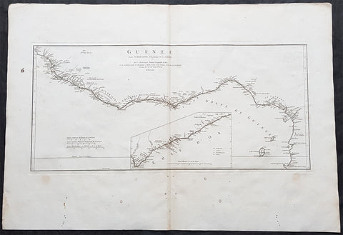
1775 J B D Anville Large Antique Map Gulf of Guinea West Africa Liberia to Gabon
- Title : Guinee Ent Serre-Lione et le pasage de la Ligne par le S D\'Anville...MDCCLXXV (1775)
- Size: 31in x 21 1/2in (790mm x 550mm)
- Condition: (A) Very Good Condition
- Date : 1775
- Ref #: 92325
Description:
This large original copper-plate engraved antique map of The Gulf Of Guinea, West Africa from Liberia to Gabon by Jean Baptiste Bourguignon D\'Anville was engraved in 1775 - dated in the tile cartouche - and was published in Jean-Baptiste Bourguinon D\'Anvilles large elephant folio atlas Atlas Generale.
(Ref: Tooley, M&B)
General Definitions:
Paper thickness and quality: - Heavy and stable
Paper color : - off white
Age of map color: -
Colors used: -
General color appearance: -
Paper size: - 31in x 21 1/2in (790mm x 550mm)
Plate size: - 21in x 19 1/2in (670mm x 320mm)
Margins: - Min 2in (50mm)
Imperfections:
Margins: - Light soiling in margins, small worm holes in bottom margin
Plate area: - None
Verso: - Light soiling
Background:
Being part of the Mediterranean world, the northern coasts of the African continent as far as the Straits of Gibraltar and even round to the area of the Fortunate Isles (the Canaries) were reasonably well known and quite accurately mapped from ancient times. In particular, Egypt and the Nile Valley were well defined and the Nile itself was, of course, one of the rivers separating the continents in medieval T-O maps. Through Arab traders the shape of the east coast, down the Red Sea as far as the equator, was also known but detail shown in the interior faded into deserts with occasional mountain ranges and mythical rivers. The southern part of the continent, in the Ptolemaic tradition, was assumed to curve to the east to form a land-locked Indian Ocean. The voyages of the Portuguese, organized by Henry the Navigator in the fifteenth century, completely changed the picture and by the end of the century Vasco da Gama had rounded the Cape enabling cartographers to draw a quite presentable coastal outline of the whole continent, even if the interior was to remain largely unknown for the next two or three centuries.
The first separately printed map of Africa (as with the other known continents) appeared in Munster\\\'s Geographia from 1540 onwards and the first atlas devoted to Africa only was published in 1588 in Venice by Livio Sanuto, but the finest individual map of the century was that engraved on 8 sheets by Gastaldi, published in Venice in 1564. Apart from maps in sixteenth-century atlases generally there were also magnificent marine maps of 1596 by Jan van Linschoten (engraved by van Langrens) of the southern half of the continent with highly imaginative and decorative detail in the interior. In the next century there were many attractive maps including those of Mercator/Hondius (1606), Speed (1627), Blaeu (1 630), Visscher (1636), de Wit (c. 1670), all embellished with vignettes of harbours and principal towns and bordered with elaborate and colourful figures of their inhabitants, but the interior remained uncharted with the exception of that part of the continent known as Ethiopia, the name which was applied to a wide area including present-day Abyssinia. Here the legends of Prester John lingered on and, as so often happened in other remote parts of the world, the only certain knowledge of the region was provided by Jesuit missionaries. Among these was Father Geronimo Lobo (1595-1678), whose work A Voyage to Abyssinia was used as the basis for a remarkably accurate map published by a German scholar, Hiob Ludolf in 1683. Despite the formidable problems which faced them, the French cartographers G. Delisle (c. 1700-22), J. B. B. d\\\'Anville (1727-49) and N. Bellin (1754) greatly improved the standards of mapping of the continent, improvements which were usually, although not always, maintained by Homann, Seutter, de Ia Rochette, Bowen, Faden and many others in the later years of the century.
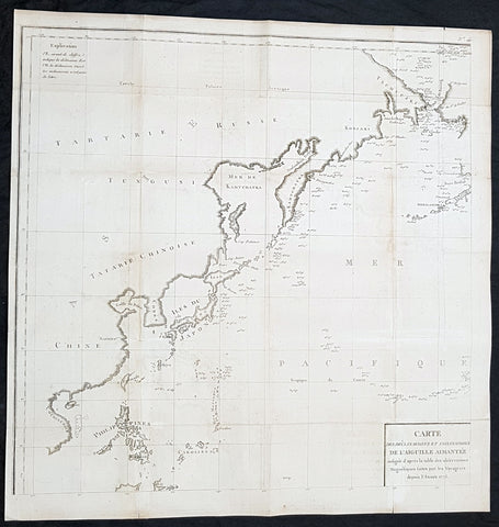
1775 La Perouse Antique Map of NW Pacific, Bering Straits to China, Philippines
Antique Map
- Title : Carte des Declinaisons et inclinaisons de l\'Aiguille Aimantee redigee d apres la table des observations Magnetiques faites par les Voyageurs depuis l Annee 1775
- Size: 24in x 24in (520mm x 520mm)
- Condition: (A+) Fine Condition
- Date : 1775
- Ref #: 32192
Description:
This large original copper plate engraved antique NW Pacific - from the Bering Straits to China & The Philippines - by Jean-François de Galaup, Comte de la Pérouse was engraved in 1775 and published in Count de Buffons monumental publication Histoire Naturelle
General Definitions:
Paper thickness and quality: - Heavy and stable
Paper color : - off white
Age of map color: -
Colors used: -
General color appearance: -
Paper size: - 24in x 24in (520mm x 520mm)
Plate size: - 24in x 24in (520mm x 520mm)
Margins: - Min 1/2in (12mm)
Imperfections:
Margins: - None
Plate area: - Folds as issued, light toning along folds
Verso: - None
Background:
This map is one of 8 charts which records the first detailed & documented the earths magnetism. Compiled from the reports of La Perouse last voyage in the Pacific.
An uncommon chart designed to display magnetic variation in the Pacific, published in Count de Buffons Histoire Naturelle, in the mineralogy volumes. As this section was not as popular as the bird volumes it is believed that only 250 copies of this edition were printed.
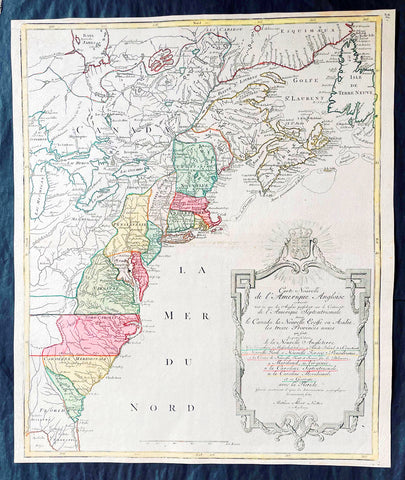
1776 Tobias Lotter Large Antique Post Revolutionary North America Map 13 Colonies
Antique Map
- Title : Carte Nouvelle de l Amerique Angloise Contenant Tout ce que les Anglois Possedent sur le Continent de l'Amerique Septentrionale Savior le Canada, la Nouvelle Ecosse ou Acadie, les Treize Provinces Unies ... avec la Floride
- Ref #: 27009
-
Condition: (A+) Fine Condition
- Size: 25in x 21 1/2in (635mm x 545mm)
- Date : 1776
Description:
This is possibly one of the last significant maps, of the original 13 American colonies, published prior to the American Revolution for Independence from Britain, beginning in 1763 and ending with the signing of the Declaration of Independence in 1776.
Published in Augsberg, Germany in 1776 by Conrad Tobias Lotter, this large original antique map reflects both the French & German interests in North America just prior to the outbreak of hostilities.
The map covers the area from the James Bay to the Gulf of Mexico and west to Lake Michigan. It shows provinces, towns and cities, some forts and trails, as well as Indian villages and tribal territory. (Ref: Tooley, M&B)
General Definitions:
Paper thickness and quality: - Heavy and stable
Paper color : - off white
Age of map color: - Original & later
Colors used: - Yellow, green, blue, pink
General color appearance: - Authentic
Paper size: - 25in x 21 1/2in (635mm x 545mm)
Plate size: - 24in x 19 1/2in (610mm x 495mm)
Margins: - Min 1/2in (12mm)
Imperfections:
Margins: - None
Plate area: - None
Verso: - None
Background:
Each of the thirteen Colonies is identified by name both on the map, and in the title. The title is placed within an attractive decorative border surmounted by the British Royal arms. The French title and nomenclature indicates that Lotter, a leading German mapmaker, intended this for the French market, as does the fact that he limits the claims of the British to the regions east of the Appalachian Mountains. The delineation of the thirteen Provinces unies is generally well done (although Maryland and Georgia are both strangely shaped): a number of locations are named in the Ohio Valley, including Logs Town, Twictwees, Ft. Du Quesne, Allegheny, Vinango, Buffaloons, Sandoski and Mingos. Some interesting details are also shown in the region of the Great Lakes.
Please note all items auctioned are genuine, we do not sell reproductions. A Certificate of Authenticity (COA) can be issued on request.
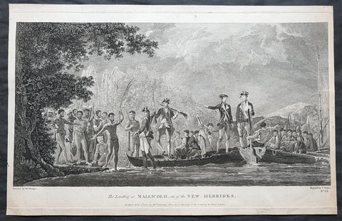
1777 Capt Cook Antique Print View of Cook Landing on Malakula Island, Vanuatu in 1774
Antique Map
- Title : The Landing at Mallicolo one of the New Hebrides...Published Feb 1st 1777 by Wm. Strahan
- Ref : 91223
- Size: 19in x 12 ½in (485mm x 320mm)
- Date : 1777
- Condition: (A) Very Good Condition
Description:
This fine original copper-plate engraved antique print of Captain James Cook & his men landing on the Island of Malakula (Mallicolo) in the Vanuatu group of Islands in the South Pacific, visited by Cook during his 2nd Voyage of Discovery to the South Seas in 1774, was engraved by James Basire - after William Hodges - and was published in Captain James Cooks 1777 edition of A voyage towards the South Pole, and round the World. Performed in His Majestys ships the Resolution and Adventure, in the years 1772, 1773, 1774, and 1775. printed by William Strahan, New Street, Shoe Lane, & Thos. Cadell, in the Strand, London 1777.
General Definitions:
Paper thickness and quality: - Heavy and stable
Paper color : - off white
Age of map color: -
Colors used: -
General color appearance: -
Paper size: - 19in x 12 ½in (485mm x 320mm)
Plate size: - 19in x 12in (480mm x 305mm)
Margins: - Min 1/2in (12mm)
Imperfections:
Margins: - None
Plate area: - Two very small worm holes
Verso: - None
Background:
Malakula Island also spelled Malekula, is the second-largest island in the nation of Vanuatu, in the Pacific Ocean region of Melanesia.
First discovered by the Spanish expedition of Pedro Fernández de Quirós in 1606 and visited by Captain James Cook in 1774.
Vanuatu officially the Republic of Vanuatu is a Pacific island nation located in the South Pacific Ocean. The archipelago, which is of volcanic origin, is 1,750 kilometres east of northern Australia, 540 kilometres northeast of New Caledonia, east of New Guinea, southeast of the Solomon Islands, and west of Fiji.
Vanuatu was first inhabited by Melanesian people. The first Europeans to visit the islands were a Spanish expedition led by Portuguese navigator Fernandes de Queirós, who arrived on the largest island in 1606. Since the Portuguese and Spanish monarchies had been unified under the king of Spain in 1580 (following the vacancy of the Portuguese throne, which lasted for sixty years, until 1640, when the Portuguese monarchy was restored), Queirós claimed the archipelago for Spain, as part of the colonial Spanish East Indies, and named it La Austrialia del Espiritu Santo.
The Vanuatu group of islands first had contact with Europeans in 1606, when the Portuguese explorer Pedro Fernandes de Queiros, sailing for the Spanish Crown, arrived on the largest island and called the group of islands La Austrialia del Espiritu Santo or The Southern Land of the Holy Spirit, believing he had arrived in Terra Australis or Australia. The Spanish established a short-lived settlement at Big Bay on the north side of the island. The name Espiritu Santo remains to this day.
Europeans did not return until 1768, when Louis Antoine de Bougainville rediscovered the islands on 22 May, naming them the Great Cyclades. In 1774, Captain Cook named the islands the New Hebrides, a name that would last until independence in 1980.
William Hodges RA 1744 – 1797 was an English painter. He was a member of James Cooks second voyage to the Pacific Ocean, and is best known for the sketches and paintings of locations he visited on that voyage, including Table Bay, Tahiti, Easter Island, and the Antarctic.
Between 1772 and 1775 Hodges accompanied James Cook to the Pacific as the expeditions artist. Many of his sketches and wash paintings were adapted as engravings in the original published edition of Cooks journals from the voyage.
Most of the large-scale landscape oil paintings from his Pacific travels for which Hodges is best known were finished after his return to London; he received a salary from the Admiralty for the purposes of completing them. These paintings depicted a stronger light and shadow than had been usual in European landscape tradition. Contemporary art critics complained that his use of light and colour contrasts gave his paintings a rough and unfinished appearance.
Hodges also produced many valuable portrait sketches of Pacific islanders and scenes from the voyage involving members of the expedition.
James Basire 1730–1802, also known as James Basire Sr., was an English engraver. He is the most significant of a family of engravers, and noted for his apprenticing of the young William Blake.
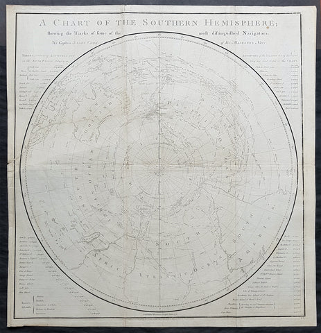
1777 Capt James Cook Antique Map of the Southern Hemisphere, 1st Ed - Australia
- Title : A Chart of the Southern Hemisphere shewing the Tracks of some of the most distinguished Navigators by Captain James Cook of His Majestys Navy
- Ref : 61111
- Size: 23 1/2in x 22 1/2in (605mm x 575mm)
- Date : 1777
- Condition: (A) Very Good Condition
Description:
This fine original 1st edition, copper-plate engraved, antique map, a chart of the Southern Hemisphere, was engraved by William Whitchurch in 1776 - dated - and is dedicated to the discoveries in the South Seas and Antarctic Regions of Captain James Cook during his second Voyage of Discovery between 1772 & 1775. By comparison the tracks of 11 other explorers are included, from the 16th to the 18th centuries. The map by Captain James Cook was published in the 1777 edition of A voyage towards the South Pole, and round the World. Performed in His Majestys ships the Resolution and Adventure, in the years 1772, 1773, 1774, and 1775.published by William Strahan, New Street, Shoe Lane, & Thos. Cadell, in the Strand, London 1777.
This map is unique in another way, was used by Nathaniel Dance in his 1776 portrait of Captain James Cook. Please also see below for more information & above for the portrait.
The 11 other explorers and their tracks around the Southern Hemisphere are;
1. Mendana in 1595
2. Quiros in 1606
3. Le Maire & Schouten in 1616
4. Tasman in 1642
5. Halley in 1700
6. Roggewein in 1722
7. Bouvet in 1738-39
8. Byron in 1765
9. Wallis in 1767
10. Bougainville in 1768
11. Surville in 1769
12. Cooks first and second voyages.
General Definitions:
Paper thickness and quality: - Heavy and stable
Paper color : - off white
Age of map color: -
Colors used: -
General color appearance: -
Paper size: - 23 1/2in x 22 1/2in (605mm x 575mm)
Plate size: - 23in x 21 1/2in (585mm x 545mm)
Margins: - Min 1/2in (12mm)
Imperfections:
Margins: - Repair as noted in plate Plate area
Plate area: - 9in repair to the left of the image from NZ to margin, no loss. Folds as issued
Verso: - Repair as noted in plate Plate area
Background:
This map by James Cook, was published as the premier map of his second voyage to the Southern Hemisphere, dispelling forever the myth of the Great Southern Land and showing the true cartographic nature of the southern hemisphere dominated by Australia & New Zealand. The map on a South Polar Projection also shows South America, the South Atlantic Ocean, South Africa, Madagascar, Australia - with Tasmania still joined to the mainland - New Zealand and the southern Pacific Ocean with islands.
Engraved within the explorer\'s tracks are the dates of their voyages and ships tracks are particularly noted around the Antarctic Circle with notations of ice fields seen during the voyages.
Nathaniel Dance Portrait of Cook, 1776
A three-quarter-length portrait of Captain Cook, seated to the left, facing the right. He is wearing captain\'s full-dress uniform, 1774-87, consisting of a navy blue jacket, white waistcoat with gold braid and gold buttons and white breeches. He wears a grey wig or his own hair powdered. He holds his own chart of the Southern Ocean on the table and his right hand points to the east coast of Australia on it. His left thumb and finger lightly hold the other edge of the chart over his knee. His hat sits on the table behind him to the left on top of a substantial book, perhaps his journal, itself resting on the chart. In 1772, Cook sailed for the second time to the fringes of the Antarctic and the Pacific, returning in 1775. He sat for this portrait, commissioned by Sir Joseph Banks, \'for a few hours before dinner\' on 25 May 1776 but it is not known whether he did so again before he left London on 24 June for his third voyage, never to return. None the less, David Samwell, surgeon\'s mate in \'Resolution\' on the second voyage and surgeon of \'Discovery\' on the third, thought it \'a most excellent likeness ... and ... the only one I have seen that bears any resemblance to him\'. This view was based on John Sherwin\'s later engraving of the portrait, which probably argues even more favourably for the original despite an element of idealization, not least omission of a large burn scar (from 1764) on the right hand. Banks had sailed with Cook on his first voyage in the \'Endeavour\' and took an influential interest in his subsequent ones. This portrait hung over the fireplace in the library of his London house. After his death, it was presented to the Naval Gallery at Greenwich Hospital by his executor, Sir Edward Knatchbull, following a request by E.H. Locker, the Hospital Secretary. In 1781-83 Charles Grignion, then in Rome, painted a \'Death of Captain Cook\' which was sold in 1821 after the British Museum declined it as a bequest from his brother Thomas, a well-known watchmaker. That picture subsequently disappeared but Thomas\'s will says the likeness of Cook was based on the present portrait. Dance worked with Pompeo Batoni in Rome and on his return to London in 1765 achieved success as a portrait and history painter. In 1768, he joined a group of artists who successfully petitioned George III to establish the Royal Academy in that year.
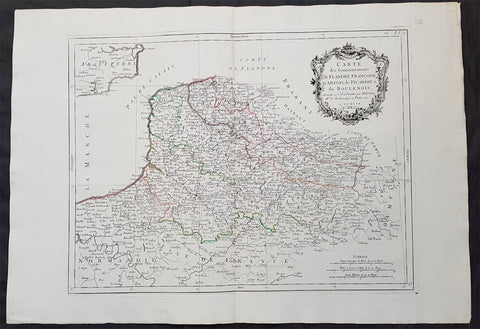
1777 F. Santini Antique Map Flanders Artois Hainaut Picardy Regions of Belgium
- Title : Carte Des Gouvernements de Flandre Francois d Artois de Picardie et du Boulenois...P Santini...1777
- Size: 30in x 21in (760mm x 535mm)
- Condition: (A+) Fine Condition
- Date : 1777
- Ref #: 50221
Description:
This large magnificent original copper-plate engraved antique map of Belgium and parts of Northern France made up of the provinces of Flanders, Artois, Hainaut, Picardy was engraved in 1777 - the date is engraved in the title cartouche - after Rigobert Bonne in 1771 and was published by Francois Santini (active 1776-84) in his 2 volume edition of Atlas Universal 1776-84.. (Ref: Tooley; M&B)
General Definitions:
Paper thickness and quality: - Heavy and stable
Paper color : - off white
Age of map color: - Original
Colors used: - Blue, pink, red, green, yellow
General color appearance: - Authentic
Paper size: - 30in x 21in (760mm x 535mm)
Plate size: - 23in x 18in (585mm x 460mm)
Margins: - Min 2in (50mm)
Imperfections:
Margins: - None
Plate area: - None
Verso: - None
Background:
Belgium officially the Kingdom of Belgium, is a country in Western Europe bordered by France, the Netherlands, Germany and Luxembourg.
Historically, Belgium was part of an area known as the Low Countries, a somewhat larger region than the current Benelux group of states that also included parts of northern France and western Germany. Its name is derived from the Latin word Belgica, after the Roman province of Gallia Belgica. From the end of the Middle Ages until the 17th century, the area of Belgium was a prosperous and cosmopolitan centre of commerce and culture. Between the 16th and early 19th centuries, Belgium served as the battleground between many European powers, earning the moniker the Battlefield of Europe, a reputation strengthened by both world wars. The country emerged in 1830 following the Belgian Revolution when it seceded from the Netherlands.
The Eighty Years War (1568–1648) divided the Low Countries into the northern United Provinces (Belgica Foederata in Latin, the Federated Netherlands) and the Southern Netherlands (Belgica Regia, the Royal Netherlands). The latter were ruled successively by the Spanish (Spanish Netherlands) and the Austrian Habsburgs (Austrian Netherlands) and comprised most of modern Belgium. This was the theatre of most Franco-Spanish and Franco-Austrian wars during the 17th and 18th centuries.
Following the campaigns of 1794 in the French Revolutionary Wars, the Low Countries—including territories that were never nominally under Habsburg rule, such as the Prince-Bishopric of Liège—were annexed by the French First Republic, ending Austrian rule in the region. The reunification of the Low Countries as the United Kingdom of the Netherlands occurred at the dissolution of the First French Empire in 1815, after the defeat of Napoleon.
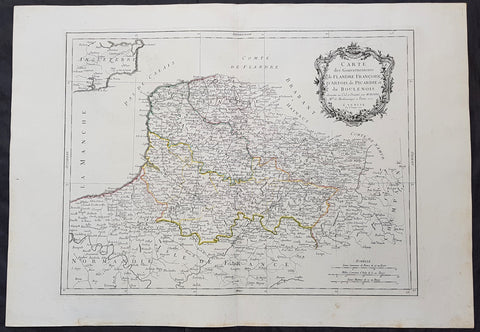
1777 F. Santini Antique Map Flanders Artois Hainaut Picardy Regions of Belgium
- Title : Carte Des Gouvernements de Flandre Francois d Artois de Picardie et du Boulenois...P Santini...1777
- Size: 30in x 21in (760mm x 535mm)
- Condition: (A+) Fine Condition
- Date : 1777
- Ref #: 50219
Description:
This large magnificent original copper-plate engraved antique map of Belgium and parts of Northern France made up of the provinces of Flanders, Artois, Hainaut, Picardy was engraved in 1777 - the date is engraved in the title cartouche - after Rigobert Bonne in 1771 and was published by Francois Santini (active 1776-84) in his 2 volume edition of Atlas Universal 1776-84.. (Ref: Tooley; M&B)
General Definitions:
Paper thickness and quality: - Heavy and stable
Paper color : - off white
Age of map color: - Original
Colors used: - Blue, pink, red, green, yellow
General color appearance: - Authentic
Paper size: - 30in x 21in (760mm x 535mm)
Plate size: - 23in x 18in (585mm x 460mm)
Margins: - Min 2in (50mm)
Imperfections:
Margins: - None
Plate area: - None
Verso: - None
Background:
Belgium officially the Kingdom of Belgium, is a country in Western Europe bordered by France, the Netherlands, Germany and Luxembourg.
Historically, Belgium was part of an area known as the Low Countries, a somewhat larger region than the current Benelux group of states that also included parts of northern France and western Germany. Its name is derived from the Latin word Belgica, after the Roman province of Gallia Belgica. From the end of the Middle Ages until the 17th century, the area of Belgium was a prosperous and cosmopolitan centre of commerce and culture. Between the 16th and early 19th centuries, Belgium served as the battleground between many European powers, earning the moniker the Battlefield of Europe, a reputation strengthened by both world wars. The country emerged in 1830 following the Belgian Revolution when it seceded from the Netherlands.
The Eighty Years War (1568–1648) divided the Low Countries into the northern United Provinces (Belgica Foederata in Latin, the Federated Netherlands) and the Southern Netherlands (Belgica Regia, the Royal Netherlands). The latter were ruled successively by the Spanish (Spanish Netherlands) and the Austrian Habsburgs (Austrian Netherlands) and comprised most of modern Belgium. This was the theatre of most Franco-Spanish and Franco-Austrian wars during the 17th and 18th centuries.
Following the campaigns of 1794 in the French Revolutionary Wars, the Low Countries—including territories that were never nominally under Habsburg rule, such as the Prince-Bishopric of Liège—were annexed by the French First Republic, ending Austrian rule in the region. The reunification of the Low Countries as the United Kingdom of the Netherlands occurred at the dissolution of the First French Empire in 1815, after the defeat of Napoleon.
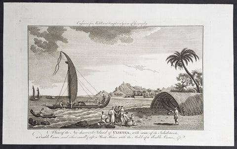
1777 Middleton Antique Print Island of Raiatea, French Polnesia - Cooks 1st Voyage 1769
- Title : View of the new discoverd island of Ulietea, with some of its inhabitants, a double canoe, and other small craft, a boat house with the model of a double canoe, & c.
- Size: 14in x 9in (355mm x 230mm)
- Ref #: 21758
- Date : 1787
- Condition: (A+) Fine Condition
Description:
This fine original cooper-plate engraved antique print of a view of the Island of Raiatea (Ulietea) during Captain Cooks 1st Voyage of discovery to the South Seas in 1769 was published in Charles Theodore Middletons 1777 edition of A New and Complete System of Geography..... published by James Cooke London, 1777.
General Definitions:
Paper thickness and quality: - Heavy and stable
Paper color : - off white
Age of map color: -
Colors used: -
General color appearance: -
Paper size: - 14in x 9in (355mm x 230mm)
Plate size: - 11in x 7in (280mm x 180mm)
Margins: - Min 1/2in (12mm)
Imperfections:
Margins: - None
Plate area: - None
Verso: - None
Background:
Raiatea, is the second largest of the Society Islands, after Tahiti, in French Polynesia. The island is widely regarded as the centre of the eastern islands in ancient Polynesia and it is likely that the organised migrations to Hawaii, Aotearoa and other parts of East Polynesia started at Raiātea.
A traditional name for the island is Havaii, homeland of the Māori people.
The first European to record sighting Ra\\\'iātea was Pedro Fernandes de Queirós in 1606; it was charted as La Fugitiva The Polynesian navigator, Tupaia, who sailed with explorer James Cook, was born in Ra\\\'iātea around 1725.
Cook visited Raiatea in 1769 and again in 1773-1774. Omai (c.1751-1780), another young man from Raiātea, traveled with the European explorers to London in 1774 and also served as an interpreter to Captain Cook on his second and third journey.
King Tamatoa VI was the last monarch, reigning from 1884-1888.
Cooks First Voyage (1768-1771)
The first voyage under Captain James Cooks command was primarily of a scientific nature. The expedition on the Endeavour initially sailed to Tahiti to observe the transit of the planet Venus in order to calculate the earth\\\'s distance from the sun. Cook landed on the South Pacific island in April of 1769 and in June of that year the astronomical observations were successfully completed. In addition to these labors, very good relations with the Tahitians were maintained and the naturalists Joseph Banks and Daniel C. Solander conducted extensive ethnological and botanical research.
Another purpose of the voyage was to explore the South Seas to determine if an inhabitable continent existed in the mid-latitudes of the Southern Hemisphere. Upon leaving Tahiti, Cook named and charted the Society Islands and then continued southwest to New Zealand. His circumnavigation and exploration of that country also resulted in a detailed survey. Cook proceeded to Australia, where he charted the eastern coast for 2,000 miles, naming the area New South Wales. As a result of these surveys, both Australia and New Zealand were annexed by Great Britain. In addition to these explorations, the Endeavour returned to England without a single death from scurvy among its men, an historic feat at the time. The combination of these accomplishments brought Cook prominence, promotion, and the opportunity to lead further expeditions.
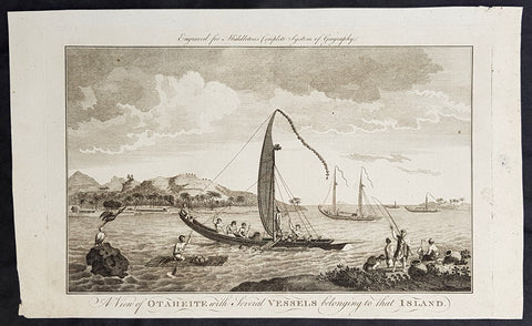
1777 Middleton Antique Print of Tahiti in French Polynesia Cooks 2nd Voyage 1773
- Title : A View of Otaheite with Several Vessels belonging to that Island
- Size: 14in x 9in (355mm x 230mm)
- Ref #: 21665
- Date : 1777
- Condition: (A+) Fine Condition
Description:
This fine original cooper-plate engraved antique print of a view of the Island of Tahiti in French Polynesia and the different type of boats of the Island during Captain Cooks 2nd Voyage of discovery to the South Seas in 1773 was published in Charles Theodore Middletons 1777 edition of A New and Complete System of Geography..... published by James Cooke London, 1777.
General Definitions:
Paper thickness and quality: - Heavy and stable
Paper color : - off white
Age of map color: -
Colors used: -
General color appearance: -
Paper size: - 14in x 9in (355mm x 230mm)
Plate size: - 11in x 7in (280mm x 180mm)
Margins: - Min 1/2in (12mm)
Imperfections:
Margins: - None
Plate area: - None
Verso: - None
Background:
Raiatea, is the second largest of the Society Islands, after Tahiti, in French Polynesia. The island is widely regarded as the centre of the eastern islands in ancient Polynesia and it is likely that the organised migrations to Hawaii, Aotearoa and other parts of East Polynesia started at Raiātea.
A traditional name for the island is Havaii, homeland of the Māori people.
The first European to record sighting Ra\\\'iātea was Pedro Fernandes de Queirós in 1606; it was charted as La Fugitiva The Polynesian navigator, Tupaia, who sailed with explorer James Cook, was born in Ra\\\'iātea around 1725.
Cook visited Raiatea in 1769 and again in 1773-1774. Omai (c.1751-1780), another young man from Raiātea, traveled with the European explorers to London in 1774 and also served as an interpreter to Captain Cook on his second and third journey.
King Tamatoa VI was the last monarch, reigning from 1884-1888.
Cooks Second Voyage (1772–75)
Shortly after his return from the first voyage, Cook was promoted in August 1771, to the rank of commander. In 1772 he was commissioned to lead another scientific expedition on behalf of the Royal Society, to search for the hypothetical Terra Australis. On his first voyage, Cook had demonstrated by circumnavigating New Zealand that it was not attached to a larger landmass to the south. Although he charted almost the entire eastern coastline of Australia, showing it to be continental in size, the Terra Australis was believed to lie further south. Despite this evidence to the contrary, Alexander Dalrymple and others of the Royal Society still believed that a massive southern continent should exist.
Cook commanded HMS Resolution on this voyage, while Tobias Furneaux commanded its companion ship, HMS Adventure. Cook\\\'s expedition circumnavigated the globe at an extreme southern latitude, becoming one of the first to cross the Antarctic Circle (17 January 1773). In the Antarctic fog, Resolution and Adventure became separated. Furneaux made his way to New Zealand, where he lost some of his men during an encounter with Māori, and eventually sailed back to Britain, while Cook continued to explore the Antarctic, reaching 71°10\\\'S on 31 January 1774.
Cook almost encountered the mainland of Antarctica, but turned towards Tahiti to resupply his ship. He then resumed his southward course in a second fruitless attempt to find the supposed continent. On this leg of the voyage he brought a young Tahitian named Omai, who proved to be somewhat less knowledgeable about the Pacific than Tupaia had been on the first voyage. On his return voyage to New Zealand in 1774, Cook landed at the Friendly Islands, Easter Island, Norfolk Island, New Caledonia, and Vanuatu.
Before returning to England, Cook made a final sweep across the South Atlantic from Cape Horn and surveyed, mapped and took possession for Britain of South Georgia, which had been explored by Anthony de la Roché in 1675. Cook also discovered and named Clerke Rocks and the South Sandwich Islands (\\\"Sandwich Land\\\"). He then turned north to South Africa, and from there continued back to England. His reports upon his return home put to rest the popular myth of Terra Australis.
Cook\\\'s second voyage marked a successful employment of Larcum Kendall\\\'s K1 copy of John Harrison\\\'s H4 marine chronometer, which enabled Cook to calculate his longitudinal position with much greater accuracy. Cook\\\'s log was full of praise for this time-piece which he used to make charts of the southern Pacific Ocean that were so remarkably accurate that copies of them were still in use in the mid-20th century.
Upon his return, Cook was promoted to the rank of post-captain and given an honorary retirement from the Royal Navy, with a posting as an officer of the Greenwich Hospital. He reluctantly accepted, insisting that he be allowed to quit the post if an opportunity for active duty should arise. His fame extended beyond the Admiralty; he was made a Fellow of the Royal Society, and awarded the Copley Gold Medal for completing his second voyage without losing a man to scurvy. Nathaniel Dance-Holland painted his portrait; he dined with James Boswell; he was described in the House of Lords as \\\"the first navigator in Europe\\\". But he could not be kept away from the sea. A third voyage was planned and Cook volunteered to find the Northwest Passage. He travelled to the Pacific and hoped to travel east to the Atlantic, while a simultaneous voyage travelled the opposite route.
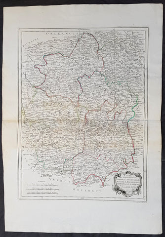
1777 Santini Antique Map French Provinces, Bourges Nevers Guéret Moulins Limoges
- Title : Carte Des Gouvernements du Berri, du Nivernois, de la Marche, du Bourbonnois, du Limosim et de L Auvergne...Par M Bonne 1771....A Venise...P Santini...1777
- Date : 1777
- Condition: (A+) Fine Condition
- Ref: 50197
- Size: 30in x 21in (760mm x 535mm)
Description:
This large magnificent original copper-plate engraved antique map of French Provinces of Berry (Bourges) Nivernais (Nevers) Marche (Guéret) Bourbonnais (Moulins) Limousin (Limoges) & Auvergne (Clermont-Ferrand) was engraved in 1777 - the date is engraved in the title cartouche - after Robert Bonne and was published by Francois Santini (active 1776-84) in his 2 volume edition of Atlas Universal 1776-84. (Ref: Tooley; M&B)
General Definitions:
Paper thickness and quality: - Heavy and stable
Paper color : - off white
Age of map color: - Original
Colors used: - Blue, pink, red, green, yellow
General color appearance: - Authentic
Paper size: - 30in x 21in (760mm x 535mm)
Plate size: - 23in x 17in (595mm x 430mm)
Margins: - Min 1in (25mm)
Imperfections:
Margins: - None
Plate area: - None
Verso: - Light age toning
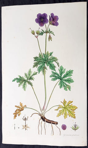
1777 W. Curtis Large Antique Botanical Print Geranium Pratense, Meadow Geranium
Antique Map
- Title : Geranium Pratense. Crowfoot-Leaved Cranes Bill
- Ref #: 93480
- Size: 19in x 11 1/2in (490mm x 295mm)
- Date : 1777 - 1798
- Condition: (A) Very Good Condition
Description:
This beautifully hand coloured original copper-plate engraved antique botanical print by William Curtis was published in his large 1st edition folio edition of his famous and most enduring 6 volumes of Flora Londinensis: or, plates and descriptions of such plants as grow wild in the environs of London: with their places of growth, and times of flowering, their several names according to Linnæus and other authors: with a particular description of each plant in Latin and English. To which are added, their several uses in medicine, agriculture, rural economy and other arts. published between 1777 & 1798.
Also accompanying the print is the original text page, giving an in-depth description of the plant and its attributes.
General Definitions:
Paper thickness and quality: - Heavy and stable
Paper color : - off white
Age of map color: - Original
Colors used: - Yellow, green, blue, pink
General color appearance: - Authentic
Paper size: - 19in x 11 1/2in (490mm x 295mm)
Plate size: - 9 1/2in x 6 1/2in (240mm x 165mm)
Margins: - Min 1in (25mm)
Imperfections:
Margins: - Light top left corner crease
Plate area: - Light spotting
Verso: - None
Background:
Flora Londinensis is a book that described the flora found in the London region of the mid 18th century. The Flora was published by William Curtis in six large volumes. The descriptions of the plants included hand-coloured copperplate plates by botanical artists such as James Sowerby, Sydenham Edwards and William Kilburn.
The full title is Flora Londinensis: or, plates and descriptions of such plants as grow wild in the environs of London: with their places of growth, and times of flowering, their several names according to Linnæus and other authors: with a particular description of each plant in Latin and English. To which are added, their several uses in medicine, agriculture, rural œconomy and other arts.
The first volume was produced in 1777 and the final one, containing a title and an index, was published in 1798. A binary name is given for each species in the survey; common and other names are also provided. Previous works on the flora of Britain had been intended for scientists, apothecaries, and herbalists, while Flora Londinensis was written for the general reader. The appealing plates also provided botanical details which could assist in the identification of a species.
Curtis was praefectus horti (Director, Society of Apothecaries) at the Chelsea Physic Garden and a botanist with a broad knowledge of exotic species. However, Flora Londinensis covered the territory most familiar to him -- the flowering species within a 10-mile radius of London. He commissioned several painters to produce hand-coloured copper engravings to accompany the pages. Curtis wrote the descriptions and managed the publishing and sales of the volumes, producing six fascicles of twelve issues, each containing six plates. The final survey eventually came to include many species found in southern England and a few others.
Despite praise for the volumes, no more than 300 copies were produced. Many other works were to be issued but it was not yet economical to produce a more affordable volume. Curtiss The Botanical Magazine would be a greater financial success. Sowerby, who helped to publish the volumes and give over seventy of the plates, went on to produce natural history publications in a similar format.
The work was enlarged by William J. Hooker, who published an edition with his own text in 1817 and 1828. This enlargement was even more comprehensive, by including species from the other British Isles.
Curtis, William 1746 - 1799
Curtis was an English botanist and entomologist, who was born at Alton, Hampshire, site of the Curtis Museum.
Curtis began as an apothecary, before turning his attention to botany and other natural history. The publications he prepared reached a wider audience than early works on the subject had intended. At the age of 25 he produced Instructions for collecting and preserving insects; particularly moths and butterflies.
Curtis was demonstrator of plants and Praefectus Horti at the Chelsea Physic Garden from 1771 to 1777. He established his own London Botanic Garden at Lambeth in 1779, moving to Brompton in 1789. He published Flora Londinensis (6 volumes, 1777–1798), a pioneering work in that it devoted itself to urban nature. Financial success was not found, but he went on the publish The Botanical Magazine in 1787, a work that would also feature hand coloured plates by artists such as James Sowerby and Sydenham Edwards. (William Kilburn is often erroneously cited as having contributed plates to Curtis\\\' Botanical Magazine. Though he did provide illustrations to Flora Londinensis, his association with Curtis seems to have ended by 1977, 10 years before the first publication of the Botanical Magazine)
Curtis was to gain wealth from the ventures into publishing, short sales on Londinensis were offset by over 3,000 copies of the magazine. Curtis said they had each brought \\\'pudding or praise\\\'.
The genus Curtisia is named in his honour. His publication was continued as the esteemed botanical publication, Curtis\\\'s Botanical Magazine. The noted natural history illustrators, James Sowerby and Sydenham Edwards both found a start with the eminent magazine.
He is commemorated in a stained glass window at St. Mary\\\'s Church, Battersea, as many of his samples were collected from the churchyard there.
This botanist is denoted by the author abbreviation Curtis when citing a botanical name.
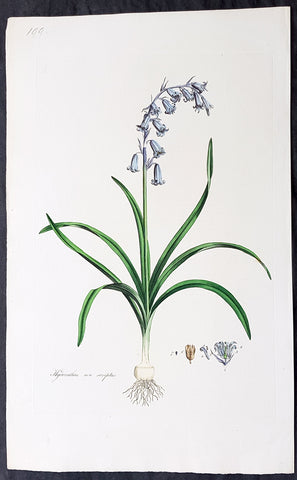
1777 W. Curtis Large Antique Botanical Print of Hyacinthus Non-Scriptus Bluebell
Antique Map
- Title : Hyacinthus Non-Scriptus. English Hyacinth or Harebell
- Ref #: 93476
- Size: 19in x 11 1/2in (490mm x 295mm)
- Date : 1777 - 1798
- Condition: (A+) Fine Condition
Description:
This beautifully hand coloured original copper-plate engraved antique botanical print by William Curtis was published in his large 1st edition folio edition of his famous and most enduring 6 volumes of Flora Londinensis: or, plates and descriptions of such plants as grow wild in the environs of London: with their places of growth, and times of flowering, their several names according to Linnæus and other authors: with a particular description of each plant in Latin and English. To which are added, their several uses in medicine, agriculture, rural economy and other arts. published between 1777 & 1798.
Also accompanying the print is the original text page, giving an in-depth description of the plant and its attributes.
General Definitions:
Paper thickness and quality: - Heavy and stable
Paper color : - off white
Age of map color: - Original
Colors used: - Yellow, green, blue, pink
General color appearance: - Authentic
Paper size: - 19in x 11 1/2in (490mm x 295mm)
Plate size: - 9 1/2in x 6 1/2in (240mm x 165mm)
Margins: - Min 1in (25mm)
Imperfections:
Margins: - None
Plate area: - None
Verso: - None
Background:
Flora Londinensis is a book that described the flora found in the London region of the mid 18th century. The Flora was published by William Curtis in six large volumes. The descriptions of the plants included hand-coloured copperplate plates by botanical artists such as James Sowerby, Sydenham Edwards and William Kilburn.
The full title is Flora Londinensis: or, plates and descriptions of such plants as grow wild in the environs of London: with their places of growth, and times of flowering, their several names according to Linnæus and other authors: with a particular description of each plant in Latin and English. To which are added, their several uses in medicine, agriculture, rural œconomy and other arts.
The first volume was produced in 1777 and the final one, containing a title and an index, was published in 1798. A binary name is given for each species in the survey; common and other names are also provided. Previous works on the flora of Britain had been intended for scientists, apothecaries, and herbalists, while Flora Londinensis was written for the general reader. The appealing plates also provided botanical details which could assist in the identification of a species.
Curtis was praefectus horti (Director, Society of Apothecaries) at the Chelsea Physic Garden and a botanist with a broad knowledge of exotic species. However, Flora Londinensis covered the territory most familiar to him -- the flowering species within a 10-mile radius of London. He commissioned several painters to produce hand-coloured copper engravings to accompany the pages. Curtis wrote the descriptions and managed the publishing and sales of the volumes, producing six fascicles of twelve issues, each containing six plates. The final survey eventually came to include many species found in southern England and a few others.
Despite praise for the volumes, no more than 300 copies were produced. Many other works were to be issued but it was not yet economical to produce a more affordable volume. Curtiss The Botanical Magazine would be a greater financial success. Sowerby, who helped to publish the volumes and give over seventy of the plates, went on to produce natural history publications in a similar format.
The work was enlarged by William J. Hooker, who published an edition with his own text in 1817 and 1828. This enlargement was even more comprehensive, by including species from the other British Isles.
Curtis, William 1746 - 1799
Curtis was an English botanist and entomologist, who was born at Alton, Hampshire, site of the Curtis Museum.
Curtis began as an apothecary, before turning his attention to botany and other natural history. The publications he prepared reached a wider audience than early works on the subject had intended. At the age of 25 he produced Instructions for collecting and preserving insects; particularly moths and butterflies.
Curtis was demonstrator of plants and Praefectus Horti at the Chelsea Physic Garden from 1771 to 1777. He established his own London Botanic Garden at Lambeth in 1779, moving to Brompton in 1789. He published Flora Londinensis (6 volumes, 1777–1798), a pioneering work in that it devoted itself to urban nature. Financial success was not found, but he went on the publish The Botanical Magazine in 1787, a work that would also feature hand coloured plates by artists such as James Sowerby and Sydenham Edwards. (William Kilburn is often erroneously cited as having contributed plates to Curtis\\\' Botanical Magazine. Though he did provide illustrations to Flora Londinensis, his association with Curtis seems to have ended by 1977, 10 years before the first publication of the Botanical Magazine)
Curtis was to gain wealth from the ventures into publishing, short sales on Londinensis were offset by over 3,000 copies of the magazine. Curtis said they had each brought \\\'pudding or praise\\\'.
The genus Curtisia is named in his honour. His publication was continued as the esteemed botanical publication, Curtis\\\'s Botanical Magazine. The noted natural history illustrators, James Sowerby and Sydenham Edwards both found a start with the eminent magazine.
He is commemorated in a stained glass window at St. Mary\\\'s Church, Battersea, as many of his samples were collected from the churchyard there.
This botanist is denoted by the author abbreviation Curtis when citing a botanical name.
1777 W. Curtis Large Antique Botanical Print of Ligustrum vulgare or Privet Bush
Antique Map
- Title : Liustrum Vulgare. Privet, or Prim.
- Ref #: 93475
- Size: 19in x 11 1/2in (490mm x 295mm)
- Date : 1777 - 1798
- Condition: (A+) Fine Condition
Description:
This beautifully hand coloured original copper-plate engraved antique botanical print by William Curtis was published in his large 1st edition folio edition of his famous and most enduring 6 volumes of Flora Londinensis: or, plates and descriptions of such plants as grow wild in the environs of London: with their places of growth, and times of flowering, their several names according to Linnæus and other authors: with a particular description of each plant in Latin and English. To which are added, their several uses in medicine, agriculture, rural economy and other arts. published between 1777 & 1798.
Also accompanying the print is the original text page, giving an in-depth description of the plant and its attributes.
General Definitions:
Paper thickness and quality: - Heavy and stable
Paper color : - off white
Age of map color: - Original
Colors used: - Yellow, green, blue, pink
General color appearance: - Authentic
Paper size: - 19in x 11 1/2in (490mm x 295mm)
Plate size: - 9 1/2in x 6 1/2in (240mm x 165mm)
Margins: - Min 1in (25mm)
Imperfections:
Margins: - None
Plate area: - None
Verso: - None
Background:
Flora Londinensis is a book that described the flora found in the London region of the mid 18th century. The Flora was published by William Curtis in six large volumes. The descriptions of the plants included hand-coloured copperplate plates by botanical artists such as James Sowerby, Sydenham Edwards and William Kilburn.
The full title is Flora Londinensis: or, plates and descriptions of such plants as grow wild in the environs of London: with their places of growth, and times of flowering, their several names according to Linnæus and other authors: with a particular description of each plant in Latin and English. To which are added, their several uses in medicine, agriculture, rural œconomy and other arts.
The first volume was produced in 1777 and the final one, containing a title and an index, was published in 1798. A binary name is given for each species in the survey; common and other names are also provided. Previous works on the flora of Britain had been intended for scientists, apothecaries, and herbalists, while Flora Londinensis was written for the general reader. The appealing plates also provided botanical details which could assist in the identification of a species.
Curtis was praefectus horti (Director, Society of Apothecaries) at the Chelsea Physic Garden and a botanist with a broad knowledge of exotic species. However, Flora Londinensis covered the territory most familiar to him -- the flowering species within a 10-mile radius of London. He commissioned several painters to produce hand-coloured copper engravings to accompany the pages. Curtis wrote the descriptions and managed the publishing and sales of the volumes, producing six fascicles of twelve issues, each containing six plates. The final survey eventually came to include many species found in southern England and a few others.
Despite praise for the volumes, no more than 300 copies were produced. Many other works were to be issued but it was not yet economical to produce a more affordable volume. Curtiss The Botanical Magazine would be a greater financial success. Sowerby, who helped to publish the volumes and give over seventy of the plates, went on to produce natural history publications in a similar format.
The work was enlarged by William J. Hooker, who published an edition with his own text in 1817 and 1828. This enlargement was even more comprehensive, by including species from the other British Isles.
Curtis, William 1746 - 1799
Curtis was an English botanist and entomologist, who was born at Alton, Hampshire, site of the Curtis Museum.
Curtis began as an apothecary, before turning his attention to botany and other natural history. The publications he prepared reached a wider audience than early works on the subject had intended. At the age of 25 he produced Instructions for collecting and preserving insects; particularly moths and butterflies.
Curtis was demonstrator of plants and Praefectus Horti at the Chelsea Physic Garden from 1771 to 1777. He established his own London Botanic Garden at Lambeth in 1779, moving to Brompton in 1789. He published Flora Londinensis (6 volumes, 1777–1798), a pioneering work in that it devoted itself to urban nature. Financial success was not found, but he went on the publish The Botanical Magazine in 1787, a work that would also feature hand coloured plates by artists such as James Sowerby and Sydenham Edwards. (William Kilburn is often erroneously cited as having contributed plates to Curtis\\\' Botanical Magazine. Though he did provide illustrations to Flora Londinensis, his association with Curtis seems to have ended by 1977, 10 years before the first publication of the Botanical Magazine)
Curtis was to gain wealth from the ventures into publishing, short sales on Londinensis were offset by over 3,000 copies of the magazine. Curtis said they had each brought \\\'pudding or praise\\\'.
The genus Curtisia is named in his honour. His publication was continued as the esteemed botanical publication, Curtis\\\'s Botanical Magazine. The noted natural history illustrators, James Sowerby and Sydenham Edwards both found a start with the eminent magazine.
He is commemorated in a stained glass window at St. Mary\\\'s Church, Battersea, as many of his samples were collected from the churchyard there.
This botanist is denoted by the author abbreviation Curtis when citing a botanical name.
1777 W. Curtis Large Antique Botanical Print of Linaria Vulgaris Yellow Toadflax
Antique Map
- Title : Linaria Vulgaris. Yellow Toadflax
- Ref #: 93470
- Size: 19in x 11 1/2in (490mm x 295mm)
- Date : 1777 - 1798
- Condition: (A+) Fine Condition
Description:
This beautifully hand coloured original copper-plate engraved antique botanical print by William Curtis was published in his large 1st edition folio edition of his famous and most enduring 6 volumes of Flora Londinensis: or, plates and descriptions of such plants as grow wild in the environs of London: with their places of growth, and times of flowering, their several names according to Linnæus and other authors: with a particular description of each plant in Latin and English. To which are added, their several uses in medicine, agriculture, rural economy and other arts. published between 1777 & 1798.
Also accompanying the print is the original text page, giving an in-depth description of the plant and its attributes.
General Definitions:
Paper thickness and quality: - Heavy and stable
Paper color : - off white
Age of map color: - Original
Colors used: - Yellow, green, blue, pink
General color appearance: - Authentic
Paper size: - 19in x 11 1/2in (490mm x 295mm)
Plate size: - 9 1/2in x 6 1/2in (240mm x 165mm)
Margins: - Min 1in (25mm)
Imperfections:
Margins: - None
Plate area: - None
Verso: - None
Background:
Flora Londinensis is a book that described the flora found in the London region of the mid 18th century. The Flora was published by William Curtis in six large volumes. The descriptions of the plants included hand-coloured copperplate plates by botanical artists such as James Sowerby, Sydenham Edwards and William Kilburn.
The full title is Flora Londinensis: or, plates and descriptions of such plants as grow wild in the environs of London: with their places of growth, and times of flowering, their several names according to Linnæus and other authors: with a particular description of each plant in Latin and English. To which are added, their several uses in medicine, agriculture, rural œconomy and other arts.
The first volume was produced in 1777 and the final one, containing a title and an index, was published in 1798. A binary name is given for each species in the survey; common and other names are also provided. Previous works on the flora of Britain had been intended for scientists, apothecaries, and herbalists, while Flora Londinensis was written for the general reader. The appealing plates also provided botanical details which could assist in the identification of a species.
Curtis was praefectus horti (Director, Society of Apothecaries) at the Chelsea Physic Garden and a botanist with a broad knowledge of exotic species. However, Flora Londinensis covered the territory most familiar to him -- the flowering species within a 10-mile radius of London. He commissioned several painters to produce hand-coloured copper engravings to accompany the pages. Curtis wrote the descriptions and managed the publishing and sales of the volumes, producing six fascicles of twelve issues, each containing six plates. The final survey eventually came to include many species found in southern England and a few others.
Despite praise for the volumes, no more than 300 copies were produced. Many other works were to be issued but it was not yet economical to produce a more affordable volume. Curtiss The Botanical Magazine would be a greater financial success. Sowerby, who helped to publish the volumes and give over seventy of the plates, went on to produce natural history publications in a similar format.
The work was enlarged by William J. Hooker, who published an edition with his own text in 1817 and 1828. This enlargement was even more comprehensive, by including species from the other British Isles.
Curtis, William 1746 - 1799
Curtis was an English botanist and entomologist, who was born at Alton, Hampshire, site of the Curtis Museum.
Curtis began as an apothecary, before turning his attention to botany and other natural history. The publications he prepared reached a wider audience than early works on the subject had intended. At the age of 25 he produced Instructions for collecting and preserving insects; particularly moths and butterflies.
Curtis was demonstrator of plants and Praefectus Horti at the Chelsea Physic Garden from 1771 to 1777. He established his own London Botanic Garden at Lambeth in 1779, moving to Brompton in 1789. He published Flora Londinensis (6 volumes, 1777–1798), a pioneering work in that it devoted itself to urban nature. Financial success was not found, but he went on the publish The Botanical Magazine in 1787, a work that would also feature hand coloured plates by artists such as James Sowerby and Sydenham Edwards. (William Kilburn is often erroneously cited as having contributed plates to Curtis\\\' Botanical Magazine. Though he did provide illustrations to Flora Londinensis, his association with Curtis seems to have ended by 1977, 10 years before the first publication of the Botanical Magazine)
Curtis was to gain wealth from the ventures into publishing, short sales on Londinensis were offset by over 3,000 copies of the magazine. Curtis said they had each brought \\\'pudding or praise\\\'.
The genus Curtisia is named in his honour. His publication was continued as the esteemed botanical publication, Curtis\\\'s Botanical Magazine. The noted natural history illustrators, James Sowerby and Sydenham Edwards both found a start with the eminent magazine.
He is commemorated in a stained glass window at St. Mary\\\'s Church, Battersea, as many of his samples were collected from the churchyard there.
This botanist is denoted by the author abbreviation Curtis when citing a botanical name.
1777 W. Curtis Large Antique Botanical Print of Lychnis Dioica - Red Campion
Antique Map
- Title : Lychnis Dioica flore rubro. Red Campion
- Ref #: 93473
- Size: 19in x 11 1/2in (490mm x 295mm)
- Date : 1777 - 1798
- Condition: (A+) Fine Condition
Description:
This beautifully hand coloured original copper-plate engraved antique botanical print by William Curtis was published in his large 1st edition folio edition of his famous and most enduring 6 volumes of Flora Londinensis: or, plates and descriptions of such plants as grow wild in the environs of London: with their places of growth, and times of flowering, their several names according to Linnæus and other authors: with a particular description of each plant in Latin and English. To which are added, their several uses in medicine, agriculture, rural economy and other arts. published between 1777 & 1798.
Also accompanying the print is the original text page, giving an in-depth description of the plant and its attributes.
General Definitions:
Paper thickness and quality: - Heavy and stable
Paper color : - off white
Age of map color: - Original
Colors used: - Yellow, green, blue, pink
General color appearance: - Authentic
Paper size: - 19in x 11 1/2in (490mm x 295mm)
Plate size: - 9 1/2in x 6 1/2in (240mm x 165mm)
Margins: - Min 1in (25mm)
Imperfections:
Margins: - None
Plate area: - None
Verso: - None
Background:
Flora Londinensis is a book that described the flora found in the London region of the mid 18th century. The Flora was published by William Curtis in six large volumes. The descriptions of the plants included hand-coloured copperplate plates by botanical artists such as James Sowerby, Sydenham Edwards and William Kilburn.
The full title is Flora Londinensis: or, plates and descriptions of such plants as grow wild in the environs of London: with their places of growth, and times of flowering, their several names according to Linnæus and other authors: with a particular description of each plant in Latin and English. To which are added, their several uses in medicine, agriculture, rural œconomy and other arts.
The first volume was produced in 1777 and the final one, containing a title and an index, was published in 1798. A binary name is given for each species in the survey; common and other names are also provided. Previous works on the flora of Britain had been intended for scientists, apothecaries, and herbalists, while Flora Londinensis was written for the general reader. The appealing plates also provided botanical details which could assist in the identification of a species.
Curtis was praefectus horti (Director, Society of Apothecaries) at the Chelsea Physic Garden and a botanist with a broad knowledge of exotic species. However, Flora Londinensis covered the territory most familiar to him -- the flowering species within a 10-mile radius of London. He commissioned several painters to produce hand-coloured copper engravings to accompany the pages. Curtis wrote the descriptions and managed the publishing and sales of the volumes, producing six fascicles of twelve issues, each containing six plates. The final survey eventually came to include many species found in southern England and a few others.
Despite praise for the volumes, no more than 300 copies were produced. Many other works were to be issued but it was not yet economical to produce a more affordable volume. Curtiss The Botanical Magazine would be a greater financial success. Sowerby, who helped to publish the volumes and give over seventy of the plates, went on to produce natural history publications in a similar format.
The work was enlarged by William J. Hooker, who published an edition with his own text in 1817 and 1828. This enlargement was even more comprehensive, by including species from the other British Isles.
Curtis, William 1746 - 1799
Curtis was an English botanist and entomologist, who was born at Alton, Hampshire, site of the Curtis Museum.
Curtis began as an apothecary, before turning his attention to botany and other natural history. The publications he prepared reached a wider audience than early works on the subject had intended. At the age of 25 he produced Instructions for collecting and preserving insects; particularly moths and butterflies.
Curtis was demonstrator of plants and Praefectus Horti at the Chelsea Physic Garden from 1771 to 1777. He established his own London Botanic Garden at Lambeth in 1779, moving to Brompton in 1789. He published Flora Londinensis (6 volumes, 1777–1798), a pioneering work in that it devoted itself to urban nature. Financial success was not found, but he went on the publish The Botanical Magazine in 1787, a work that would also feature hand coloured plates by artists such as James Sowerby and Sydenham Edwards. (William Kilburn is often erroneously cited as having contributed plates to Curtis\\\' Botanical Magazine. Though he did provide illustrations to Flora Londinensis, his association with Curtis seems to have ended by 1977, 10 years before the first publication of the Botanical Magazine)
Curtis was to gain wealth from the ventures into publishing, short sales on Londinensis were offset by over 3,000 copies of the magazine. Curtis said they had each brought \\\'pudding or praise\\\'.
The genus Curtisia is named in his honour. His publication was continued as the esteemed botanical publication, Curtis\\\'s Botanical Magazine. The noted natural history illustrators, James Sowerby and Sydenham Edwards both found a start with the eminent magazine.
He is commemorated in a stained glass window at St. Mary\\\'s Church, Battersea, as many of his samples were collected from the churchyard there.
This botanist is denoted by the author abbreviation Curtis when citing a botanical name.
1777 W. Curtis Large Antique Botanical Print of Primula Veris,The Common Cowslip
Antique Map
- Title : Primula Veris. Cowslip
- Ref #: 93477
- Size: 19in x 11 1/2in (490mm x 295mm)
- Date : 1777 - 1798
- Condition: (A+) Fine Condition
Description:
This beautifully hand coloured original copper-plate engraved antique botanical print by William Curtis was published in his large 1st edition folio edition of his famous and most enduring 6 volumes of Flora Londinensis: or, plates and descriptions of such plants as grow wild in the environs of London: with their places of growth, and times of flowering, their several names according to Linnæus and other authors: with a particular description of each plant in Latin and English. To which are added, their several uses in medicine, agriculture, rural economy and other arts. published between 1777 & 1798.
Also accompanying the print is the original text page, giving an in-depth description of the plant and its attributes.
General Definitions:
Paper thickness and quality: - Heavy and stable
Paper color : - off white
Age of map color: - Original
Colors used: - Yellow, green, blue, pink
General color appearance: - Authentic
Paper size: - 19in x 11 1/2in (490mm x 295mm)
Plate size: - 9 1/2in x 6 1/2in (240mm x 165mm)
Margins: - Min 1in (25mm)
Imperfections:
Margins: - None
Plate area: - None
Verso: - None
Background:
Flora Londinensis is a book that described the flora found in the London region of the mid 18th century. The Flora was published by William Curtis in six large volumes. The descriptions of the plants included hand-coloured copperplate plates by botanical artists such as James Sowerby, Sydenham Edwards and William Kilburn.
The full title is Flora Londinensis: or, plates and descriptions of such plants as grow wild in the environs of London: with their places of growth, and times of flowering, their several names according to Linnæus and other authors: with a particular description of each plant in Latin and English. To which are added, their several uses in medicine, agriculture, rural œconomy and other arts.
The first volume was produced in 1777 and the final one, containing a title and an index, was published in 1798. A binary name is given for each species in the survey; common and other names are also provided. Previous works on the flora of Britain had been intended for scientists, apothecaries, and herbalists, while Flora Londinensis was written for the general reader. The appealing plates also provided botanical details which could assist in the identification of a species.
Curtis was praefectus horti (Director, Society of Apothecaries) at the Chelsea Physic Garden and a botanist with a broad knowledge of exotic species. However, Flora Londinensis covered the territory most familiar to him -- the flowering species within a 10-mile radius of London. He commissioned several painters to produce hand-coloured copper engravings to accompany the pages. Curtis wrote the descriptions and managed the publishing and sales of the volumes, producing six fascicles of twelve issues, each containing six plates. The final survey eventually came to include many species found in southern England and a few others.
Despite praise for the volumes, no more than 300 copies were produced. Many other works were to be issued but it was not yet economical to produce a more affordable volume. Curtiss The Botanical Magazine would be a greater financial success. Sowerby, who helped to publish the volumes and give over seventy of the plates, went on to produce natural history publications in a similar format.
The work was enlarged by William J. Hooker, who published an edition with his own text in 1817 and 1828. This enlargement was even more comprehensive, by including species from the other British Isles.
Curtis, William 1746 - 1799
Curtis was an English botanist and entomologist, who was born at Alton, Hampshire, site of the Curtis Museum.
Curtis began as an apothecary, before turning his attention to botany and other natural history. The publications he prepared reached a wider audience than early works on the subject had intended. At the age of 25 he produced Instructions for collecting and preserving insects; particularly moths and butterflies.
Curtis was demonstrator of plants and Praefectus Horti at the Chelsea Physic Garden from 1771 to 1777. He established his own London Botanic Garden at Lambeth in 1779, moving to Brompton in 1789. He published Flora Londinensis (6 volumes, 1777–1798), a pioneering work in that it devoted itself to urban nature. Financial success was not found, but he went on the publish The Botanical Magazine in 1787, a work that would also feature hand coloured plates by artists such as James Sowerby and Sydenham Edwards. (William Kilburn is often erroneously cited as having contributed plates to Curtis\\\' Botanical Magazine. Though he did provide illustrations to Flora Londinensis, his association with Curtis seems to have ended by 1977, 10 years before the first publication of the Botanical Magazine)
Curtis was to gain wealth from the ventures into publishing, short sales on Londinensis were offset by over 3,000 copies of the magazine. Curtis said they had each brought \\\'pudding or praise\\\'.
The genus Curtisia is named in his honour. His publication was continued as the esteemed botanical publication, Curtis\\\'s Botanical Magazine. The noted natural history illustrators, James Sowerby and Sydenham Edwards both found a start with the eminent magazine.
He is commemorated in a stained glass window at St. Mary\\\'s Church, Battersea, as many of his samples were collected from the churchyard there.
This botanist is denoted by the author abbreviation Curtis when citing a botanical name.
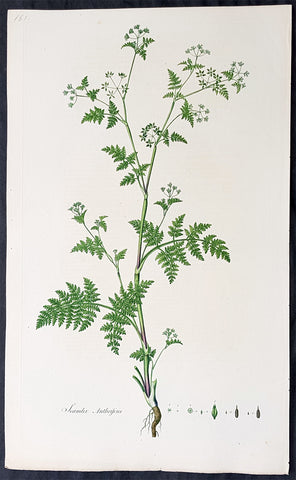
1777 W. Curtis Large Antique Botanical Print of Scandix Anthriscus Rough Chervil
Antique Map
- Title : Scandix Anthriscus. Rough Chervil
- Ref #: 93474
- Size: 19in x 11 1/2in (490mm x 295mm)
- Date : 1777 - 1798
- Condition: (A+) Fine Condition
Description:
This beautifully hand coloured original copper-plate engraved antique botanical print by William Curtis was published in his large 1st edition folio edition of his famous and most enduring 6 volumes of Flora Londinensis: or, plates and descriptions of such plants as grow wild in the environs of London: with their places of growth, and times of flowering, their several names according to Linnæus and other authors: with a particular description of each plant in Latin and English. To which are added, their several uses in medicine, agriculture, rural economy and other arts. published between 1777 & 1798.
Also accompanying the print is the original text page, giving an in-depth description of the plant and its attributes.
General Definitions:
Paper thickness and quality: - Heavy and stable
Paper color : - off white
Age of map color: - Original
Colors used: - Yellow, green, blue, pink
General color appearance: - Authentic
Paper size: - 19in x 11 1/2in (490mm x 295mm)
Plate size: - 9 1/2in x 6 1/2in (240mm x 165mm)
Margins: - Min 1in (25mm)
Imperfections:
Margins: - None
Plate area: - None
Verso: - None
Background:
Flora Londinensis is a book that described the flora found in the London region of the mid 18th century. The Flora was published by William Curtis in six large volumes. The descriptions of the plants included hand-coloured copperplate plates by botanical artists such as James Sowerby, Sydenham Edwards and William Kilburn.
The full title is Flora Londinensis: or, plates and descriptions of such plants as grow wild in the environs of London: with their places of growth, and times of flowering, their several names according to Linnæus and other authors: with a particular description of each plant in Latin and English. To which are added, their several uses in medicine, agriculture, rural œconomy and other arts.
The first volume was produced in 1777 and the final one, containing a title and an index, was published in 1798. A binary name is given for each species in the survey; common and other names are also provided. Previous works on the flora of Britain had been intended for scientists, apothecaries, and herbalists, while Flora Londinensis was written for the general reader. The appealing plates also provided botanical details which could assist in the identification of a species.
Curtis was praefectus horti (Director, Society of Apothecaries) at the Chelsea Physic Garden and a botanist with a broad knowledge of exotic species. However, Flora Londinensis covered the territory most familiar to him -- the flowering species within a 10-mile radius of London. He commissioned several painters to produce hand-coloured copper engravings to accompany the pages. Curtis wrote the descriptions and managed the publishing and sales of the volumes, producing six fascicles of twelve issues, each containing six plates. The final survey eventually came to include many species found in southern England and a few others.
Despite praise for the volumes, no more than 300 copies were produced. Many other works were to be issued but it was not yet economical to produce a more affordable volume. Curtiss The Botanical Magazine would be a greater financial success. Sowerby, who helped to publish the volumes and give over seventy of the plates, went on to produce natural history publications in a similar format.
The work was enlarged by William J. Hooker, who published an edition with his own text in 1817 and 1828. This enlargement was even more comprehensive, by including species from the other British Isles.
Curtis, William 1746 - 1799
Curtis was an English botanist and entomologist, who was born at Alton, Hampshire, site of the Curtis Museum.
Curtis began as an apothecary, before turning his attention to botany and other natural history. The publications he prepared reached a wider audience than early works on the subject had intended. At the age of 25 he produced Instructions for collecting and preserving insects; particularly moths and butterflies.
Curtis was demonstrator of plants and Praefectus Horti at the Chelsea Physic Garden from 1771 to 1777. He established his own London Botanic Garden at Lambeth in 1779, moving to Brompton in 1789. He published Flora Londinensis (6 volumes, 1777–1798), a pioneering work in that it devoted itself to urban nature. Financial success was not found, but he went on the publish The Botanical Magazine in 1787, a work that would also feature hand coloured plates by artists such as James Sowerby and Sydenham Edwards. (William Kilburn is often erroneously cited as having contributed plates to Curtis\\\' Botanical Magazine. Though he did provide illustrations to Flora Londinensis, his association with Curtis seems to have ended by 1977, 10 years before the first publication of the Botanical Magazine)
Curtis was to gain wealth from the ventures into publishing, short sales on Londinensis were offset by over 3,000 copies of the magazine. Curtis said they had each brought \\\'pudding or praise\\\'.
The genus Curtisia is named in his honour. His publication was continued as the esteemed botanical publication, Curtis\\\'s Botanical Magazine. The noted natural history illustrators, James Sowerby and Sydenham Edwards both found a start with the eminent magazine.
He is commemorated in a stained glass window at St. Mary\\\'s Church, Battersea, as many of his samples were collected from the churchyard there.
This botanist is denoted by the author abbreviation Curtis when citing a botanical name.
1777 William Curtis Large Antique Botanical Print of The Green Field-Speedwell
Antique Map
- Title : Veronica agrestis. Procumbent Speed. Well.
- Ref #: 93479
- Size: 19in x 11 1/2in (490mm x 295mm)
- Date : 1777 - 1798
- Condition: (A+) Fine Condition
Description:
This beautifully hand coloured original copper-plate engraved antique botanical print by William Curtis was published in his large 1st edition folio edition of his famous and most enduring 6 volumes of Flora Londinensis: or, plates and descriptions of such plants as grow wild in the environs of London: with their places of growth, and times of flowering, their several names according to Linnæus and other authors: with a particular description of each plant in Latin and English. To which are added, their several uses in medicine, agriculture, rural economy and other arts. published between 1777 & 1798.
Also accompanying the print is the original text page, giving an in-depth description of the plant and its attributes.
General Definitions:
Paper thickness and quality: - Heavy and stable
Paper color : - off white
Age of map color: - Original
Colors used: - Yellow, green, blue, pink
General color appearance: - Authentic
Paper size: - 19in x 11 1/2in (490mm x 295mm)
Plate size: - 9 1/2in x 6 1/2in (240mm x 165mm)
Margins: - Min 1in (25mm)
Imperfections:
Margins: - None
Plate area: - None
Verso: - None
Background:
Flora Londinensis is a book that described the flora found in the London region of the mid 18th century. The Flora was published by William Curtis in six large volumes. The descriptions of the plants included hand-coloured copperplate plates by botanical artists such as James Sowerby, Sydenham Edwards and William Kilburn.
The full title is Flora Londinensis: or, plates and descriptions of such plants as grow wild in the environs of London: with their places of growth, and times of flowering, their several names according to Linnæus and other authors: with a particular description of each plant in Latin and English. To which are added, their several uses in medicine, agriculture, rural œconomy and other arts.
The first volume was produced in 1777 and the final one, containing a title and an index, was published in 1798. A binary name is given for each species in the survey; common and other names are also provided. Previous works on the flora of Britain had been intended for scientists, apothecaries, and herbalists, while Flora Londinensis was written for the general reader. The appealing plates also provided botanical details which could assist in the identification of a species.
Curtis was praefectus horti (Director, Society of Apothecaries) at the Chelsea Physic Garden and a botanist with a broad knowledge of exotic species. However, Flora Londinensis covered the territory most familiar to him -- the flowering species within a 10-mile radius of London. He commissioned several painters to produce hand-coloured copper engravings to accompany the pages. Curtis wrote the descriptions and managed the publishing and sales of the volumes, producing six fascicles of twelve issues, each containing six plates. The final survey eventually came to include many species found in southern England and a few others.
Despite praise for the volumes, no more than 300 copies were produced. Many other works were to be issued but it was not yet economical to produce a more affordable volume. Curtiss The Botanical Magazine would be a greater financial success. Sowerby, who helped to publish the volumes and give over seventy of the plates, went on to produce natural history publications in a similar format.
The work was enlarged by William J. Hooker, who published an edition with his own text in 1817 and 1828. This enlargement was even more comprehensive, by including species from the other British Isles.
Curtis, William 1746 - 1799
Curtis was an English botanist and entomologist, who was born at Alton, Hampshire, site of the Curtis Museum.
Curtis began as an apothecary, before turning his attention to botany and other natural history. The publications he prepared reached a wider audience than early works on the subject had intended. At the age of 25 he produced Instructions for collecting and preserving insects; particularly moths and butterflies.
Curtis was demonstrator of plants and Praefectus Horti at the Chelsea Physic Garden from 1771 to 1777. He established his own London Botanic Garden at Lambeth in 1779, moving to Brompton in 1789. He published Flora Londinensis (6 volumes, 1777–1798), a pioneering work in that it devoted itself to urban nature. Financial success was not found, but he went on the publish The Botanical Magazine in 1787, a work that would also feature hand coloured plates by artists such as James Sowerby and Sydenham Edwards. (William Kilburn is often erroneously cited as having contributed plates to Curtis\\\' Botanical Magazine. Though he did provide illustrations to Flora Londinensis, his association with Curtis seems to have ended by 1977, 10 years before the first publication of the Botanical Magazine)
Curtis was to gain wealth from the ventures into publishing, short sales on Londinensis were offset by over 3,000 copies of the magazine. Curtis said they had each brought \\\'pudding or praise\\\'.
The genus Curtisia is named in his honour. His publication was continued as the esteemed botanical publication, Curtis\\\'s Botanical Magazine. The noted natural history illustrators, James Sowerby and Sydenham Edwards both found a start with the eminent magazine.
He is commemorated in a stained glass window at St. Mary\\\'s Church, Battersea, as many of his samples were collected from the churchyard there.
This botanist is denoted by the author abbreviation Curtis when citing a botanical name.
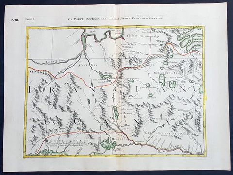
1778 Antonio Zatta & John Mitchell Antique Map of East Quebec & Western Ontario
Antique Map
- Title : La Parte Occidentale Della Nuova Francia o Canada
- Date : 1778
- Condition: (A+) Fine Condition
- Ref: 93512
- Size: 21in x 15 1/2in (535mm x 395mm)
Description:
Description:
This wonderfully executed original copper plate engraved hand coloured antique map of eastern Quebec and Western Ontario - from Lake Superior in the west to Montreal in the east and Hudson Bay in the North was published as Sheet 2, of 12, of Antonio Zattas 1778 re-issue of John Mitchells famous landmark map A Map of the British and French Dominions in North America, With the Roads, Distances, Limits, and Extent of the Settlements was published in Zattas Atlas Atlante Novissimo (1779-1785)
I have included an image of the complete 12 sheet joined map by Zatta as well as an image of Mitchells map.
General Definitions:
Paper thickness and quality: - Heavy and stable
Paper color : - off white
Age of map color: - Original
Colors used: - Yellow, green, blue, pink
General color appearance: - Authentic
Paper size: - 21in x 15 1/2in (535mm x 395mm)
Plate size: - 17 1/2in x 13 1/2in (445mm x 345mm)
Margins: - Min 1in (25mm)
Imperfections:
Margins: - None
Plate area: - None
Verso: - None
Background:
The Mitchell Map by John Mitchell (1711–1768) is considered the most famous map of North America both cartographically and historically, was reprinted several times during the second half of the 18th century. The Mitchell Map was used as a primary map source during the Treaty of Paris for defining the boundaries of the newly independent United States. The map remained important for resolving border disputes between the United States and Canada as recently as the 1980s dispute over the Gulf of Maine fisheries. The Mitchell Map is the most comprehensive map of eastern North America made during the colonial era. Its size is about 6.5 feet (2.0 m) wide by 4.5 feet (1.4 m) high.
John Mitchell was not a professional geographer or map-maker. Son of a wealthy Virginian family in Lancaster County, on Virginia's Northern Neck, he had been educated at Edinburgh University, Scotland; this education included the first two years of the three-year medical program. Returning to coastal Virginia, he practiced as a physician and studied the local botany. Ill health forced Mitchell and his wife to leave Virginia for London in 1746. There, he served as a consultant on exotic plants to noblemen interested in gardens. Also, it was there that Mitchell would make his famous map. Map historians have understandably been interested in why a physician and botanist who had shown no previous interest in map making should make such a large and detailed map.
Until recently, historians have argued that Mitchell was upset by the lack of interest shown by politicians in London about colonial affairs and so set out to warn them about the dangers posed to the British colonies by the French. Mitchell did so, on his own initiative, by making a first map of North America in 1750, which he then showed to the politicians he knew through his botanical and gardening activities. The map so impressed George Montagu-Dunk, 2nd Earl of Halifax, appointed president of the Board of Trade and Plantations in 1748, that Halifax opened up the official archives and solicited new maps from the colonies for Mitchell to make a new and better map. This was the map published in 1755. That is, the motive force for preparations against the French threat is understood to have come from a colonist who sought to take control of the colonies' future on behalf of the other colonists.
A re-examination of the archival evidence indicates, however, that Mitchell made his first map in 1750 at Halifax's behest. Halifax became president of the Board of Trade directly after the conclusion of the War of the Austrian Succession (1744–1748) and its North American component, King George's War. The war had ended in stalemate and a return to the Anglo-French status quo of the 1714 Treaty of Utrecht. In fact, it was a common conviction that it was only a matter of time before another global Anglo-French war would begin, and it was commonly expected that the spark of the new conflict would be the North American colonies. It was then that Halifax latched onto Mitchell as an expert informant on all things colonial; one of his requests, apparently, was for Mitchell to make a new map to show the territorial situation in North America. Certainly, it was only after 1749 that Mitchell's correspondence revealed his new interests in both geography and politics.
Mitchell compiled a first map in 1750 from the materials that he could find in London, in official archives and private hands. It proved to be inadequate. Halifax accordingly ordered the governors of the British colonies to send new maps, which most did. These became the basis, when fitted into the overall geographical frame provided by the maps of the French geographer Guillaume Delisle. Late in 1754, Halifax was using one manuscript copy of Mitchell's second map to successfully promote his political position (no compromise with the French) within the British cabinet in the build-up to the Seven Years' War aka French and Indian War. Halifax also permitted Mitchell to have the map published: it appeared in April 1755, engraved by Thomas Kitchin and published by Andrew Millar.
The published map bore the title A Map of the British and French Dominions in North America. It bore the copyright date of 13 February 1755, but the map was probably not sold to the public until April or even May. Minor corrections to the map's printing plates were made probably during the printing process.
The geographer John Green (né Braddock Mead) criticized Mitchell and his map soon after it appeared, emphasizing two failings with respect to Nova Scotia (an area of particular dispute with the French). Mitchell, Green noted, had used neither the astronomical observations for latitude and longitude made by Marquis Joseph Bernard de Chabert in the 1740s nor a 1715 chart of the Nova Scotia coast. In response, Mitchell released a new version of his map, now with two large blocks of text that described all of his data sources; the new version of the map also adjusted the coastline in line with Chabert's work but rejected the 1715 chart as deeply flawed. This version of the map, which Mitchell referred to as the "second edition," is commonly thought to have appeared sometime in 1757, but advertisements in the (London) Public Advertiser and Gazetteer and London Daily Advertiser on 23 April 1756 clearly indicate that this new map appeared at that time.
The map continued to be corrected and some boundaries updated, even after Mitchell's death in 1768.
Mitchell's map was printed in eight sheets; when assembled, it measures 136 cm by 195 cm (4 feet 6 inches by 6 feet 5 inches; height x width). The initial impressions printed in 1755 have a consistent coloring outlining British colonial claims. Mitchell extended the southern colonies across the entire continent, even over established Spanish territory west of the Mississippi. Mitchell divided up the Iroquois territories (as he understood them, reaching from Lake Champlain [Lac Irocoisia] to the Mississippi, and north of Lake Superior) between Virginia and New York, leaving only a much-reduced territory to the French.
Mitchell's map was expensive but it spawned many cheaper variants that trumpeted Halifax and Mitchell's powerful colonial vision to the British public. One of these, published in December 1755 by "a Society of Anti-Gallicans", restricted the French even further just to Quebec.
The map is liberally sprinkled with text describing and explaining various features, especially in regions that were relatively unknown or which were subject to political dispute. Many notes describe the natural resources and potential for settlement of frontier regions. Others describe Indian tribes. Many Indian settlements are shown, along with important Indian trails.
Since Mitchell's main objective was to show the French threat to the British colonies, there is a very strong pro-British bias in the map, especially with regard to the Iroquois. The map makes clear that the Iroquois were not just allies of Britain, but subjects, and that all Iroquois land was therefore British territory. Huge parts of the continent are noted as being British due to Iroquois conquest of one tribe or another. French activity within the Iroquois claimed lands is noted, explicitly or implicitly, as illegal.
In cases where the imperial claims of Britain and France were questionable, Mitchell always takes the British side. Thus many of his notes and boundaries seem like political propaganda today. Some of the claims seem to be outright falsehoods.
The map is very large and the notes are often very small, making it difficult to view online. Reduced scale copies result in unreadable notes. The following list gives a few examples of the kind of notes found on the map, with Mitchell's spelling:
- The region of today's central Tennessee and Kentucky (between the Tennessee and Cumberland Rivers): A Fine Level Fertile Country of great Extent, by Accounts of the Indians and our People
- In the area between the Mississippi River and the Tennessee River: This Country of the Cherokees which extends Westward to the Mississippi and Northward to the Confines of the Six Nations was formally surrendered to the Crown of Britain at Westminster 1729
- In the Great Plains: The Nadouessoians are reckoned one of the most Populous Nations of Indians in North America, altho' the number and situation of their Villages are not known nor laid down. (Reference to the Sioux)
- Along the coast of the Gulf of Mexico, present-day Texas: Wandering Savage Indians
- Southwest of Hudson Bay: The long and Barbarous Names lately given to some of these Northern Parts of Canada and the Lakes we have not inserted, as they are of no use, and uncertain Authority.
- North of Lake Huron: MESSESAGUES—Subdued by the Iroquois and now united with them making the 8th Nation in that League. (reference to the Mississaugas)
- Missouri River: Missouri River is reckoned to run Westward to the Mountains of New Mexico, as far as the Ohio does Eastward
- Present-day Iowa: Extensive Meadows full of Buffaloes
- Sandusky, Ohio: Sandoski—Canahogue—The seat of War, the Mart of Trade, & chief Hunting Grounds of the Six Nations, on the Lakes & the Ohio.
- Central Pennsylvania, north of present-day Harrisburg: St. Anthony's Wilderness
- Illinois region: The Antient Eriez were extirpated by the Iroquois upwards of 100 years ago, ever since which time they have been in Possession of L. Erie (reference to the Erie people)
- Along Illinois River and overland to the south end of Lake Michigan: Western Bounds of the Six Nations sold and Surrendered to Great Britain
- Illinois region: The Six Nations have extended their Territories to the River Illinois, ever since the Year 1672, when they subdued, and were incorporated with, the Antient Chaouanons, the Native Proprietors of these Countries, and the River Ohio. Besides which they likewise claim a Right of Conquest over the Illinois, and all the Mississippi as far as they extend. This is confirmed by their own Claims and Possessions in 1742, which include all the Bounds here laid down, and none have ever thought fit to dispute them. (reference to the Illiniwek)
- Just below the previous note: The Ohio Indians are a mixt Tribe of the Several Indians of our Colonies, settled here under the Six Nations, who have always been in Alliance and Subjection to the English. The most numerous of them are the Delaware and Shawnoes, who are Natives of Delaware River. Those about Philadelphia were called Sauwanoos whom we now call Shawanoes, or Shawnoes. The Mohickans and Minquaas were the Antient Inhabitants of Susquehanna R. (reference to the Lenape, Shawnee, and Susquehannock Indians)
- Southeast Missouri area: Mines of Marameg, which gave rise to the famous Mississippi Scheme 1719.
- North Florida: TIMOOQUA—Destroy'd by the Carolinians in 1706 (reference to the Timucua)
- South Georgia: COUNTRY OF THE APALACHEES—Conquered & surrendered to the Carolinians, after two memorable Victories obtain'd over them & the Spaniards in 1702 & 1703 at the Places marked thus [crossed-swords] (reference to the Apalachee)
- Alabama area: The English have Factories & Settlements in all the Towns of the Creek Indians of any note, except Albamas; which was usurped by the French in 1715 but established by the English 28 years before. (reference to the Creek people)
- Yazoo River: River of the Yasous—The Indians on this River were in Alliance with the English, for which they have been destroyed by the French (reference to the Yazoo tribe)
- Many geographic features are labeled with names no longer in use or oddly spelled, including:
Des Moines River: Moingona River
Kanawha and New River together: Gr. Conhaway called Wood R. or New R.
Kentucky River: Cuttawa or Catawba R.
Clinch River: Pelisipi River (a tributary is labeled Clinch's R.)
Tennessee River: River of the Cherakees, or Hogohegee R. Upstream another label says River Hogohegee or Callamaco
French Broad River: Agiqua R.
Little Tennessee River: Tannaſsee or Satico R.
Hiwassee River: Euphasee
Ohio River: Ohio or Splawacipiki R.
Altamaha River: Alatamaha or George R.
Minnesota River: Ouadebameniſsouté or R. St. Peter (reflecting the Dakota name Watpá Mnísota and the French name Rivière de St. Pierre)
Muskegon River: Maticon R.
The map also included non-existent features, such as Isle Phelipeaux in Lake Superior, found in earlier maps by Jacques-Nicolas Bellin.
The Mitchell Map remained the most detailed map of North America available in the later eighteenth century. Various impressions (and also French copies) were used to establish the boundaries of the new United States of America by diplomats at the 1783 Treaty of Paris that ended the American Revolutionary War. The map's inaccuracies subsequently led to a number of border disputes, such as in Maine. Its supposition that the Mississippi River extended north to the 50th parallel (into British territory) resulted in the treaty using it as a landmark for a geographically impossible definition of the border in that region. It was not until 1842, when the Webster-Ashburton Treaty resolved these inconsistencies with fixes such as the one that created Minnesota's Northwest Angle, that the U.S.–Canada border was clearly drawn from Maine to the Oregon Country.
Similarly, during the drafting of the Northwest Ordinance, the map's inaccuracy in depicting where an east–west line drawn through the southernmost point of Lake Michigan would intersect Lake Erie led to a long dispute over the Ohio–Michigan border that culminated in the Toledo War.
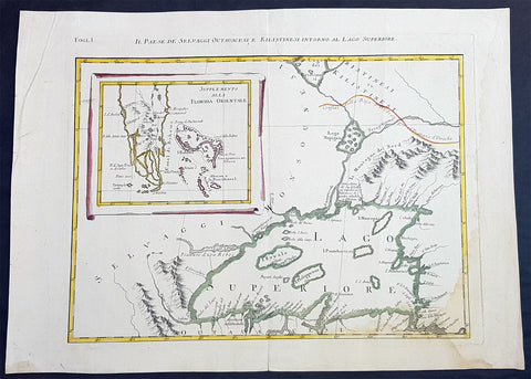
1778 Antonio Zatta & John Mitchell Antique Map of Lake Superior & Florida
Antique Map
- Title : Il Paese de Selvaggi Outauace si e Kilistinesi Intorno Al Lago Superiore; Supplemento alla Florida Orientale
- Date : 1778
- Condition: (A+) Fine Condition
- Ref: 93517
- Size: 21in x 15 1/2in (535mm x 395mm)
Description:
This wonderfully executed original copper plate engraved hand coloured antique map of Lake Superior, with an inset map of southern Florida, was published as Sheet 1, of 12, of Antonio Zattas 1778 re-issue of John Mitchells famous landmark map A Map of the British and French Dominions in North America, With the Roads, Distances, Limits, and Extent of the Settlements was published in Zattas Atlas Atlante Novissimo (1779-1785)
I have included an image of the complete 12 sheet joined map by Zatta as well as an image of Mitchells map.
General Definitions:
Paper thickness and quality: - Heavy and stable
Paper color : - off white
Age of map color: - Original
Colors used: - Yellow, green, blue, pink
General color appearance: - Authentic
Paper size: - 21in x 15 1/2in (535mm x 395mm)
Plate size: - 17 1/2in x 13 1/2in (445mm x 345mm)
Margins: - Min 1in (25mm)
Imperfections:
Margins: - None
Plate area: - None
Verso: - None
Background:
The Mitchell Map by John Mitchell (1711–1768) is considered the most famous map of North America both cartographically and historically, was reprinted several times during the second half of the 18th century. The Mitchell Map was used as a primary map source during the Treaty of Paris for defining the boundaries of the newly independent United States. The map remained important for resolving border disputes between the United States and Canada as recently as the 1980s dispute over the Gulf of Maine fisheries. The Mitchell Map is the most comprehensive map of eastern North America made during the colonial era. Its size is about 6.5 feet (2.0 m) wide by 4.5 feet (1.4 m) high.
John Mitchell was not a professional geographer or map-maker. Son of a wealthy Virginian family in Lancaster County, on Virginia's Northern Neck, he had been educated at Edinburgh University, Scotland; this education included the first two years of the three-year medical program. Returning to coastal Virginia, he practiced as a physician and studied the local botany. Ill health forced Mitchell and his wife to leave Virginia for London in 1746. There, he served as a consultant on exotic plants to noblemen interested in gardens. Also, it was there that Mitchell would make his famous map. Map historians have understandably been interested in why a physician and botanist who had shown no previous interest in map making should make such a large and detailed map.
Until recently, historians have argued that Mitchell was upset by the lack of interest shown by politicians in London about colonial affairs and so set out to warn them about the dangers posed to the British colonies by the French. Mitchell did so, on his own initiative, by making a first map of North America in 1750, which he then showed to the politicians he knew through his botanical and gardening activities. The map so impressed George Montagu-Dunk, 2nd Earl of Halifax, appointed president of the Board of Trade and Plantations in 1748, that Halifax opened up the official archives and solicited new maps from the colonies for Mitchell to make a new and better map. This was the map published in 1755. That is, the motive force for preparations against the French threat is understood to have come from a colonist who sought to take control of the colonies' future on behalf of the other colonists.
A re-examination of the archival evidence indicates, however, that Mitchell made his first map in 1750 at Halifax's behest. Halifax became president of the Board of Trade directly after the conclusion of the War of the Austrian Succession (1744–1748) and its North American component, King George's War. The war had ended in stalemate and a return to the Anglo-French status quo of the 1714 Treaty of Utrecht. In fact, it was a common conviction that it was only a matter of time before another global Anglo-French war would begin, and it was commonly expected that the spark of the new conflict would be the North American colonies. It was then that Halifax latched onto Mitchell as an expert informant on all things colonial; one of his requests, apparently, was for Mitchell to make a new map to show the territorial situation in North America. Certainly, it was only after 1749 that Mitchell's correspondence revealed his new interests in both geography and politics.
Mitchell compiled a first map in 1750 from the materials that he could find in London, in official archives and private hands. It proved to be inadequate. Halifax accordingly ordered the governors of the British colonies to send new maps, which most did. These became the basis, when fitted into the overall geographical frame provided by the maps of the French geographer Guillaume Delisle. Late in 1754, Halifax was using one manuscript copy of Mitchell's second map to successfully promote his political position (no compromise with the French) within the British cabinet in the build-up to the Seven Years' War aka French and Indian War. Halifax also permitted Mitchell to have the map published: it appeared in April 1755, engraved by Thomas Kitchin and published by Andrew Millar.
The published map bore the title A Map of the British and French Dominions in North America. It bore the copyright date of 13 February 1755, but the map was probably not sold to the public until April or even May. Minor corrections to the map's printing plates were made probably during the printing process.
The geographer John Green (né Braddock Mead) criticized Mitchell and his map soon after it appeared, emphasizing two failings with respect to Nova Scotia (an area of particular dispute with the French). Mitchell, Green noted, had used neither the astronomical observations for latitude and longitude made by Marquis Joseph Bernard de Chabert in the 1740s nor a 1715 chart of the Nova Scotia coast. In response, Mitchell released a new version of his map, now with two large blocks of text that described all of his data sources; the new version of the map also adjusted the coastline in line with Chabert's work but rejected the 1715 chart as deeply flawed. This version of the map, which Mitchell referred to as the "second edition," is commonly thought to have appeared sometime in 1757, but advertisements in the (London) Public Advertiser and Gazetteer and London Daily Advertiser on 23 April 1756 clearly indicate that this new map appeared at that time.
The map continued to be corrected and some boundaries updated, even after Mitchell's death in 1768.
Mitchell's map was printed in eight sheets; when assembled, it measures 136 cm by 195 cm (4 feet 6 inches by 6 feet 5 inches; height x width). The initial impressions printed in 1755 have a consistent coloring outlining British colonial claims. Mitchell extended the southern colonies across the entire continent, even over established Spanish territory west of the Mississippi. Mitchell divided up the Iroquois territories (as he understood them, reaching from Lake Champlain [Lac Irocoisia] to the Mississippi, and north of Lake Superior) between Virginia and New York, leaving only a much-reduced territory to the French.
Mitchell's map was expensive but it spawned many cheaper variants that trumpeted Halifax and Mitchell's powerful colonial vision to the British public. One of these, published in December 1755 by "a Society of Anti-Gallicans", restricted the French even further just to Quebec.
The map is liberally sprinkled with text describing and explaining various features, especially in regions that were relatively unknown or which were subject to political dispute. Many notes describe the natural resources and potential for settlement of frontier regions. Others describe Indian tribes. Many Indian settlements are shown, along with important Indian trails.
Since Mitchell's main objective was to show the French threat to the British colonies, there is a very strong pro-British bias in the map, especially with regard to the Iroquois. The map makes clear that the Iroquois were not just allies of Britain, but subjects, and that all Iroquois land was therefore British territory. Huge parts of the continent are noted as being British due to Iroquois conquest of one tribe or another. French activity within the Iroquois claimed lands is noted, explicitly or implicitly, as illegal.
In cases where the imperial claims of Britain and France were questionable, Mitchell always takes the British side. Thus many of his notes and boundaries seem like political propaganda today. Some of the claims seem to be outright falsehoods.
The map is very large and the notes are often very small, making it difficult to view online. Reduced scale copies result in unreadable notes. The following list gives a few examples of the kind of notes found on the map, with Mitchell's spelling:
- The region of today's central Tennessee and Kentucky (between the Tennessee and Cumberland Rivers): A Fine Level Fertile Country of great Extent, by Accounts of the Indians and our People
- In the area between the Mississippi River and the Tennessee River: This Country of the Cherokees which extends Westward to the Mississippi and Northward to the Confines of the Six Nations was formally surrendered to the Crown of Britain at Westminster 1729
- In the Great Plains: The Nadouessoians are reckoned one of the most Populous Nations of Indians in North America, altho' the number and situation of their Villages are not known nor laid down. (Reference to the Sioux)
- Along the coast of the Gulf of Mexico, present-day Texas: Wandering Savage Indians
- Southwest of Hudson Bay: The long and Barbarous Names lately given to some of these Northern Parts of Canada and the Lakes we have not inserted, as they are of no use, and uncertain Authority.
- North of Lake Huron: MESSESAGUES—Subdued by the Iroquois and now united with them making the 8th Nation in that League. (reference to the Mississaugas)
- Missouri River: Missouri River is reckoned to run Westward to the Mountains of New Mexico, as far as the Ohio does Eastward
- Present-day Iowa: Extensive Meadows full of Buffaloes
- Sandusky, Ohio: Sandoski—Canahogue—The seat of War, the Mart of Trade, & chief Hunting Grounds of the Six Nations, on the Lakes & the Ohio.
- Central Pennsylvania, north of present-day Harrisburg: St. Anthony's Wilderness
- Illinois region: The Antient Eriez were extirpated by the Iroquois upwards of 100 years ago, ever since which time they have been in Possession of L. Erie (reference to the Erie people)
- Along Illinois River and overland to the south end of Lake Michigan: Western Bounds of the Six Nations sold and Surrendered to Great Britain
- Illinois region: The Six Nations have extended their Territories to the River Illinois, ever since the Year 1672, when they subdued, and were incorporated with, the Antient Chaouanons, the Native Proprietors of these Countries, and the River Ohio. Besides which they likewise claim a Right of Conquest over the Illinois, and all the Mississippi as far as they extend. This is confirmed by their own Claims and Possessions in 1742, which include all the Bounds here laid down, and none have ever thought fit to dispute them. (reference to the Illiniwek)
- Just below the previous note: The Ohio Indians are a mixt Tribe of the Several Indians of our Colonies, settled here under the Six Nations, who have always been in Alliance and Subjection to the English. The most numerous of them are the Delaware and Shawnoes, who are Natives of Delaware River. Those about Philadelphia were called Sauwanoos whom we now call Shawanoes, or Shawnoes. The Mohickans and Minquaas were the Antient Inhabitants of Susquehanna R. (reference to the Lenape, Shawnee, and Susquehannock Indians)
- Southeast Missouri area: Mines of Marameg, which gave rise to the famous Mississippi Scheme 1719.
- North Florida: TIMOOQUA—Destroy'd by the Carolinians in 1706 (reference to the Timucua)
- South Georgia: COUNTRY OF THE APALACHEES—Conquered & surrendered to the Carolinians, after two memorable Victories obtain'd over them & the Spaniards in 1702 & 1703 at the Places marked thus [crossed-swords] (reference to the Apalachee)
- Alabama area: The English have Factories & Settlements in all the Towns of the Creek Indians of any note, except Albamas; which was usurped by the French in 1715 but established by the English 28 years before. (reference to the Creek people)
- Yazoo River: River of the Yasous—The Indians on this River were in Alliance with the English, for which they have been destroyed by the French (reference to the Yazoo tribe)
- Many geographic features are labeled with names no longer in use or oddly spelled, including:
Des Moines River: Moingona River
Kanawha and New River together: Gr. Conhaway called Wood R. or New R.
Kentucky River: Cuttawa or Catawba R.
Clinch River: Pelisipi River (a tributary is labeled Clinch's R.)
Tennessee River: River of the Cherakees, or Hogohegee R. Upstream another label says River Hogohegee or Callamaco
French Broad River: Agiqua R.
Little Tennessee River: Tannaſsee or Satico R.
Hiwassee River: Euphasee
Ohio River: Ohio or Splawacipiki R.
Altamaha River: Alatamaha or George R.
Minnesota River: Ouadebameniſsouté or R. St. Peter (reflecting the Dakota name Watpá Mnísota and the French name Rivière de St. Pierre)
Muskegon River: Maticon R.
The map also included non-existent features, such as Isle Phelipeaux in Lake Superior, found in earlier maps by Jacques-Nicolas Bellin.
The Mitchell Map remained the most detailed map of North America available in the later eighteenth century. Various impressions (and also French copies) were used to establish the boundaries of the new United States of America by diplomats at the 1783 Treaty of Paris that ended the American Revolutionary War. The map's inaccuracies subsequently led to a number of border disputes, such as in Maine. Its supposition that the Mississippi River extended north to the 50th parallel (into British territory) resulted in the treaty using it as a landmark for a geographically impossible definition of the border in that region. It was not until 1842, when the Webster-Ashburton Treaty resolved these inconsistencies with fixes such as the one that created Minnesota's Northwest Angle, that the U.S.–Canada border was clearly drawn from Maine to the Oregon Country.
Similarly, during the drafting of the Northwest Ordinance, the map's inaccuracy in depicting where an east–west line drawn through the southernmost point of Lake Michigan would intersect Lake Erie led to a long dispute over the Ohio–Michigan border that culminated in the Toledo War.
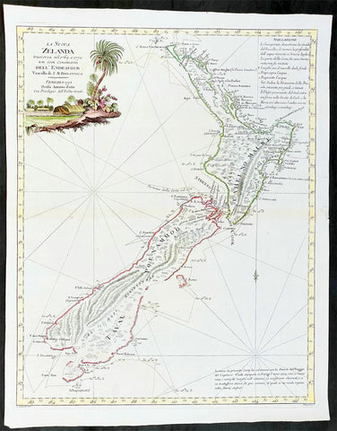
1778 Antonio Zatta Antique Map of New Zealand af. Captain James Cook - Beautiful
Antique Map
- Title : La Nuova Zelanda trascorsa nel 1769 e 1770 d'al Cook Comandante dell' Endeavour Vascello di S. M. Britannica . . . 1778
- Ref #: 93527
-
Condition: (A+) Fine Condition
- Size: 19 1/2in x 15 1/2in (495mm x 395mm)
- Date : 1778
Description:
This impressive original hand coloured copper-plate engraved very early antique map of New Zealand, after Captain James Cook, was engraved in 1778 (the first edition with a second dated 1791) was published by Antonio Zatta in his 1779 edition of Atlante Novissimo
This is a beautifully engraved map after Captain James Cooks surveys of 1769. Cook published the first compete map of NZ in 1774, with this more decorative map being published by Zatta some 4 years later. The map contains all of Cooks coastal survey detail with some details of the interior of the islands. Also included are the tracks of Cooks ship HMS Endeavour as he surveyed the coast as well as his approach and exit from New Zealand. Beautiful original hand colour, with a heavy impression denoting an early pressing.
The maps of Venetian publisher Antonio Zatta are noteworthy for their fine craftsmanship and high aesthetics. He was probably the most important Italian map publisher of the late eighteenth century and is responsible for a large number of atlases and single maps of considerable aesthetic and scientific merit.
General Definitions:
Paper thickness and quality: - Heavy and stable
Paper color : - off white
Age of map color: - Original
Colors used: - Yellow, green, blue, pink
General color appearance: - Authentic
Paper size: - 19 1/2in x 15 1/2in (495mm x 395mm)
Plate size: - 18in x 14in (455mm x 355mm)
Margins: - Min 1/2in (12mm)
Imperfections:
Margins: - None
Plate area: - None
Verso: - None
Background:
New Zealand (or Aotearoa, as the Maori call it) had been first encountered by Europeans in the early 1640s, when Dutch explorer Abel Tasman named the land "Nieuw Zeeland" after the Dutch province. Importantly, Tasman only sailed up the west coast of the North Island and had little notion as to the nature of the islands or their broader geographical context. A small number of Tasman's place names were preserved by Cook (and remain in place to this day), including 'Cape Maria van Diemen' (the northernmost point of the North Island) and the 'Three Kings' islets, where Cook and his men celebrated the Christmas of 1769-the first Europeans to visit the islands for nearly 130 years.
Captain James Cook (1728-1779) is considered to be the greatest explorer of the eighteenth century and was the finest maritime cartographer of the Age of Enlightenment. Having first worked on coal colliers and then distinguished himself as a surveyor in Eastern Canada, in 1768 he became the British Admiralty's choice to lead an unprecedented voyage of discovery. The central impetus for the expedition was to observe the Transit of Venus from Tahiti and then to proceed to explore Terra Australis Incognita, the supposedly rich southern continent. Whereas the first part of the voyage was to be conducted under the auspices of international scientific cooperation, the second part was entirely clandestine and was only communicated to Cook via "Secret Instructions" to be opened once at sea.
Cook's party left Plymouth in August 1768 aboard the converted coal collier HMS Endeavor and proceeded to Tahiti by way of Cape Horn. They arrived in time to observe the Transit of Venus, which occurred June 3, 1769. Cook then proceeded towards New Zealand, to the coordinates recorded by Tasman. As New Zealand was quite conceivably part of Terra Australis, it was Cook's intention to carefully explore and map the region.
On October 6, 1769, the Endeavor sighted the North Island (Te Ika a Maui) at Turanga Nui, which Cook renamed Poverty Bay. He and his crew had arrived on the opposite shore to where Tasman had met the island. Cook proceeded to the South Island (Te Wai Pounamu), carefully mapping both landmasses with a running survey. He used soundings, visual observations, and triangulation regulated by astronomical observations to create his manuscript charts.
Despite being constantly buffeted by wind and rain, and after having some hostile relations with the Maori that resulted in Maori deaths, Cook and his crew managed to circumnavigate both the North and South Islands, proving that they were separate islands divided by the Cook Strait. They also proved the islands were not connected to any southern continent. On March 31, 1770, Cook wrote in his journal that the Endeavour's voyage:
…must be allowed to have set a side the most, if not all, the arguments and proofs that have been advanced by different Authors to prove that there must be a Southern Continent; I mean to the northward of 40 degrees South, for what may lay to the Southward of that Latitude I know not (Cook, Journals I, 290).
The Endeavor left New Zealand at Cape Farewell, sailing west towards Australia, where Cook's crew would become the first Europeans to explore that region. In total, they had surveyed over 2,400 miles of New Zealand coastline in six months.
Upon the Endeavour's return to England in July 1771, Cook became a national hero. He would go on to lead two further voyages that would succeed in illuminating most of the Pacific Ocean to European eyes. On the second expedition, Cook would put to rest the myth of a southern continent. On the third, he kick started the fur trade in the Pacific Northwest of North America while searching for the Northwest Passage. He was killed by Hawaiians at Kealakekua Bay in 1779.
Cook returned to England with over 300 manuscript charts and coastal views. The original manuscript chart of New Zealand is now held by the British Library (Add MS 7085, f. 16-7). The chart was drawn, at least in part, by Isaac Smith (1752-1831), a draftsman of considerable skill who worked with Cook in Newfoundland, sailed on the Endeavour and Cook's second voyage, and was related to Cook's wife. Of the New Zealand chart, Cook wrote:
The Chart which I have drawn will best point out the figure and extent of these Islands…beginning at Cape Palliser and proceed round Aehei no mouwe (North Island) by the East Cape &ca. The Coast between these two Capes I believe to be laid down pretty accurate both in its figure and the Course and distance from point to point. The oppertunities I had and the methods I made use on to obtain these requesites were such as could hardly admit of an error… some few places however must be excepted and these are very doubtfull …(Cook, Journals I, 275-6)
The overall delineation is impressively accurate, correctly capturing many of the bays and promontories, and making insightful observations of the interior. Many of the names given by Cook survive to this day, including the Alps, (the great mountain chain of the South Island), Mount Egmont (the volcano on the North Island, also known as Mount Taranaki), the Bay of Islands, the Bay of Plenty, Hawke's Bay, and most intriguingly, Cape Kidnappers (a point on the North Island where Maori warriors attempted to abduct a member of the Endeavor's crew).
There are a few errors, conspicuous only because of the otherwise superb accuracy of the chart. Notably, Cook's "Banke's Island" is in fact a peninsula, part of the South Island. Further south, what looks like a possible peninsula is actually Stewart Island, with the "Isle Solander" to the west. Also, some portions of coast line remain un-surveyed due to adverse conditions or distraction. For example, the portion of coastline near Bankes Island is but a dotted line because Lieutenant Gore had thought he sighted land to the southeast. Upon sailing toward it, the promontory proved to be clouds. Despite such mistakes, the chart is remarkably thorough.
The present chart was printed as part of the official account of Cook's first voyage, which was edited by the literary critic John Hawkesworth and underwritten by the British Admiralty. An Account of the Voyages undertaken by the order of His Present Majesty for making Discoveries in the Southern Hemisphere… (London: W. Strahan and T. Cadell, 1773) recounted the voyages not only of Cook, but of Byron, Wallis, and Carteret who had also ventured to the Pacific for the Royal Navy earlier in the 1760s. It was engraved by John Abraham Bayly (fl. 1755-1794), a London-based engraver who specialized in cartographic work.
In 1816, the British Hydrographic Office began to reprint the map for its vessels. The chart was continuously consulted into the twentieth century. Due to this longevity, its extraordinary origins, and its important place in the founding of New Zealand as a British colony, Cook's chart is considered to be the most important single map in the history of New Zealand. Due to the complexity of the assignment and the great accuracy of the survey, it is also considered to be one of Cook's very finest maps, and one of the truly great achievements of Enlightenment cartography.
Zatta, Antonio fl. 1757 - 1797
Antonio Zatta was a prominent Italian editor, cartographer, and publisher. Little is known about his life beyond his many surviving published works. It is possible that he was born as early as 1722 and lived as late as 1804. He lived in Venice and his work flourished between 1757 and 1797. He is best known for his atlas, Atlante Novissimo (1779-1785), and for his prolific output of prints and books that were both precisely made and aesthetically pleasing. Zatta clearly had a large network from which to draw information; this is how he was able to publish the first glimpse of the islands visited by Captain Cook in the Atlante Novissimo.
Zattas maps are noteworthy for their fine craftsmanship and high aesthetics. His re-engraving and publication of John Mitchells famous map of North America A Map of the British and French Dominions in North America in 1778, is considered one of the best re-issues of this seminal, landmark map .
......He was probably the most important Italian map publisher of the late eighteenth century and is responsible for a large number of atlases and single maps of considerable aesthetic and scientific merit.... (Portinaro & Knirsch, The Cartography of North America, 1500-1800, p. 319).
Zatta was among the leaders in the eighteenth-century revival of fine printing in Italy and his choice of the text of Raynal to support his re-issue of Mitchells Map, is not surprising. Anne Palms Chalmers describes Zatta as a sardonic writer with the focus of a certain amount of political controversy (Venetian Book Design in the Eighteenth Century, The Metropolitan Museum of Art Bulletin, New Series, Vol. 29, No. 5, January 1971, pp. 226-235). Chalmers describes Zattas printing and design as harmonious in composition with ornament unified by style, quality of line, and tone of printing.
Please note all items auctioned are genuine, we do not sell reproductions. A Certificate of Authenticity (COA) can be issued on request.
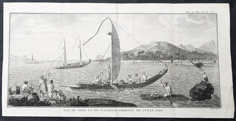
1778 Capt Cook Antique Print Matavia Bay & Boats in Tahiti French Polynesia 1773
- Title : Vue de Taiti et de plusieurs Pirogues De Cette Isle (View of the Island of Tahiti and canoes)
- Size: 15in x 7 1/2in (380mm x 190mm)
- Ref #: 21576
- Date : 1778
- Condition: (A+) Fine Condition
Description:
This large original copper-plate engraved antique print a view of
Matavia Bay, on the Island of Tahiti, with various canoes & boats, visited by Captain James Cook in August 1773, during his 2nd Voyage of Discovery to the South Seas, was engraved by Robert Benard - after William Hodges - and was published in the 1778 French edition of Capt. James Cooks 2nd Voyage of Discovery to the South Seas A voyage towards the South Pole, and round the World. Performed in His Majestys ships the Resolution and Adventure, in the years 1772, 1773, 1774, and 1775..... Paris : Hotel de Thou ......1778.
Cooks Journal 1773
On 20th Aug, wrote Cook, Nothing worthy of note happened till the Dusk of the evening when one of the Natives made off with a musquet belonging to the Guard on shore, I was present when this happen\'d and sent two or three of our people after him, this would have signified but little had not some of the natives pursued the thief, knock\'d him down and took from him the Musquet and return\'d it to us.
Three days later I set out accompanied by Captain Furneaux some of the Gentlemen and several of the Natives, we met the Chief... I knew him at first sight and he me, having seen each other several times in 1769 at which time he was but a boy. According to Wales the Capt returned from his Visit to the King, Owhyadoa, having with much difficulty, and expince in presents &c procured three Hogs.
Off to Matavai Bay
The next day, wrote Burney we hove our Anchors up & saild from this place, the Commodore leaving his Cutter behind to try if they could procure any more Hogs - the next day (25th) the Cutter returned about Noon with 10 which were divided between the 2 Ships - at 7 this Evening we Anchored in Matavia Bay in 10 fathoms & Moord with our Small Bower & Stream Anchors.
When the natives came aboard, Cook found several of whom I knew and almost all of them me... In the morning, after having given directions about erecting Tents for the reception of the Sick, Coopers and guard, I set out for Oparre accompanied by Captain Furneaux, some of the gentlemen... as soon as we landed we were conducted to Otoo [Tu], the chief.
When Cook returned, he had the Sick land, Twenty from the Adventure and one from the Resolution, landed a sufficient number of men to guard the Whole and left the command to Lieutt Edgcombe of the Marines. A party of Marines being sent on Shore as a Guard, wrote Wales, I landed my Observatory and Instruments and begun to put them up on the Spot where Mr Green Observed the Transit of Venus in 1769.
General Definitions:
Paper thickness and quality: - Heavy and stable
Paper color : - off white
Age of map color: -
Colors used: -
General color appearance: -
Paper size: - 15in x 7 1/2in (380mm x 190mm)
Plate size: - 14 1/2in x 7in (370mm x 180mm)
Margins: - Min 1/2in (12mm)
Imperfections:
Margins: - None
Plate area: - Folds as issued
Verso: - None
Background:
Tahiti previously also known as Otaheite is the largest island in the Windward group of French Polynesia. The island is located in the archipelago of the Society Islands in the central Southern Pacific Ocean.
The first European to have visited Tahiti according to existing records was lieutenant Samuel Wallis, who was circumnavigating the globe in HMS Dolphin, sighting the island on 18 June 1767, and eventually harboring in Matavai Bay. This bay was situated on the territory of the chiefdom of Pare-Arue, governed by Tu (Tu-nui-e-a a-i-te-Atua) and his regent Tutaha, and the chiefdom of Ha apape, governed by Amo and his wife Oberea (Purea). Wallis named the island King Georges Island. The first contacts were difficult, since on the 24 and 26 June 1767, Tahitian warriors in canoes showed aggression towards the British, hurling stones from their slings. In retaliation, the British sailors opened fire on the warriors in the canoes and on the hills. In reaction to this powerful counter-attack, the Tahitians laid down peace offerings for the British. Following this episode, Samuel Wallis was able to establish cordial relations with the female chieftain “Oberea “ (Purea) and remained on the island until 27 July 1767.
In July 1768, Captain James Cook was commissioned by the Royal Society and on orders from the Lords Commissioners of the Admiralty to observe the transit of Venus across the sun, a phenomenon that would be visible from Tahiti on 3 June 1769. He arrived in Tahitis Matavai Bay, commanding the HMS Endeavour on 12 April 1769. On 14 April, Cook met with Tutaha and Tepau. On 15 April, Cook picked the site for a fortified camp at Point Venus along with Banks, Parkinson, Daniel Solander, to protect Charles Greens observatory. The length of stay enabled them to undertake for the first time real ethnographic and scientific observations of the island. Assisted by the botanist Joseph Banks, and by the artist Sydney Parkinson, Cook gathered valuable information on the fauna and flora, as well as the native society, language and customs, including the proper name of the island, Otaheite. On 28 April, Cook met Purea and Tupaia, and Tupaia befriended Banks following the transit. On 21 June, Amo visited Cook, and then on 25 June, Pohuetea visited, signifying another chief seeking to ally himself with the British.
Cook and Banks circumnavigated the island from 26 June to 1 July. On the exploration, they met Ahio, chief of Ha apaiano o or Papenoo, Rita, chief of Hitia a, Pahairro, chief of Pueu, Vehiatua, chief of Tautra, Matahiapo, chief of Teahupo o, Tutea, chief of Vaira o, and Moe, chief of Afa Ahiti. In Papara, guided by Tupaia, they investigated the ruins of Mahaiatea marae, an impressive structure containing a stone pyramid or ahu, measuring 44 feet high, 267 feet long and 87 feet wide. Cook and the Endeavour departed Tahiti on 13 July 1769, taking Raiatean navigator Tupaia along for his geographic knowledge of the islands.
Cook returned to Tahiti between 15 August and 1 September 1773, greeted by the chiefs Tai and Puhi, besides the youg ari i Vehiatua II and his stepfather Ti itorea. Cook anchored in Vaitepiha Bay before returning to Point Venus where he met Tu, the paramount chief. Cook picked up two passengers from Tahiti during this trip, Porea and Mai, with Hitihiti later replacing Porea when Cook stopped at Raiatea. Cook took Hitihiti to Tahiti on 22 April, during his return leg. Then, Cook departed Tahiti on 14 May 1774.
During his final visit, Cook returned Mai to Tahiti on 12 Aug. 1777, after Mais long visit in England. Cook also brought two Maori from Queen Charlotte Sound, Te Weherua and Koa. Cook first harbored in Vaitepiha Bay, where he visited Vehiatua II s funeral bier and the prefabricated Spanish mission house. Cook also met Vehiatua III, and inscribed on the back of the Spanish cross, Georgius tertius Rex Annis 1767, 69, 73, 74 & 77, as a counterpoint to Christus Vincit Carolus III imperat 1774 on the front. On 23 Aug., Cook sailed for Matavai Bay, where he met Tu, his father Teu, his mother Tetupaia, his brothers Ari ipaea and Vaetua, and his sisters Ari ipaea-vahine, Tetua-te-ahamai, and Auo. Cook also observed a human sacrifice, taata tapu, at the Utu-ai-mahurau marae, and 49 skulls from previous victims.
On 29 Sept. 1777, Cook sailed for Papetoai Bay on Moorea. Cook met Mahine in an act of friendship on 3 Oct., though he was an enemy of Tu. When a goat kid was stolen on 6 Oct., Cook in a rampage, ordered the burning of houses and canoes until it was returned. Cook sailed for Huahine on 11 Oct., Raiatea on 2 Nov., and Borabora on 7 Dec.
On 26 October 1788, HMS Bounty, under the command of Captain William Bligh, landed in Tahiti with the mission of carrying Tahitian breadfruit trees (Tahitian: uru) to the Caribbean. Sir Joseph Banks, the botanist from James Cooks first expedition, had concluded that this plant would be ideal to feed the African slaves working in the Caribbean plantations at very little cost. The crew remained in Tahiti for about five months, the time needed to transplant the seedlings of the trees. Three weeks after leaving Tahiti, on 28 April 1789, the crew mutinied on the initiative of Fletcher Christian. The mutineers seized the ship and set the captain and most of those members of the crew who remained loyal to him adrift in a ships boat. A group of mutineers then went back to settle in Tahiti.
Although various explorers had refused to get involved in tribal conflicts, the mutineers from the Bounty offered their services as mercenaries and furnished arms to the family which became the Pōmare Dynasty. The chief Tū knew how to use their presence in the harbours favoured by sailors to his advantage. As a result of his alliance with the mutineers, he succeeded in considerably increasing his supremacy over the island of Tahiti.
William Hodges RA 1744 – 1797 was an English painter. He was a member of James Cooks second voyage to the Pacific Ocean, and is best known for the sketches and paintings of locations he visited on that voyage, including Table Bay, Tahiti, Easter Island, and the Antarctic.
Between 1772 and 1775 Hodges accompanied James Cook to the Pacific as the expeditions artist. Many of his sketches and wash paintings were adapted as engravings in the original published edition of Cooks journals from the voyage.
Most of the large-scale landscape oil paintings from his Pacific travels for which Hodges is best known were finished after his return to London; he received a salary from the Admiralty for the purposes of completing them. These paintings depicted a stronger light and shadow than had been usual in European landscape tradition. Contemporary art critics complained that his use of light and colour contrasts gave his paintings a rough and unfinished appearance.
Hodges also produced many valuable portrait sketches of Pacific islanders and scenes from the voyage involving members of the expedition..
Robert Bénard 1734 – 1777 was an 18th-century French engraver.
Specialized in the technique of engraving, Robert Ménard is mainly famous for having supplied a significant amount of plates (at least 1,800) to the Encyclopédie by Diderot & d\'Alembert from 1751.
Later, publisher Charles-Joseph Panckoucke reused many of his productions to illustrate the works of his catalog.
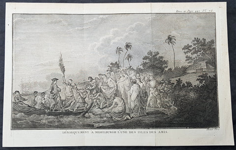
1778 Capt Cook Antique Print of Capt Cook Landing on Eua Island, Tonga in 1773
- Title : Debarquement A Middelburgh L une des Amis (Landing A Middelburgh one of the Friendly Islands)
- Size: 12in x 8in (305mm x 205mm)
- Ref #: 21357
- Date : 1778
- Condition: (A+) Fine Condition
Description:
This large original copper-plate engraved antique print of Captain Cook landing on the Island of Eua - with HMS Resolution in the background - (named Middelburg by the Dutch explorer Abel Tasman in 1643) a small island close the the main island of Tongatapu, in the Kingdom of Tonga, visited by Captain James Cook in 1773, during his 2nd Voyage of Discovery to the South Seas, was engraved by Robert Benard - after William Hodges - and was published in the 1778 French edition of Capt. James Cooks 2nd Voyage of Discovery to the South Seas A voyage towards the South Pole, and round the World. Performed in His Majestys ships the Resolution and Adventure, in the years 1772, 1773, 1774, and 1775..... Paris : Hotel de Thou ......1778.
As it was, Cook did not encounter the Tongan islands until his Second Voyage, when he stopped at both \'Eua and Tongatapu (or, by Tasman\'s nomenclature, Middleburg and Amsterdam respectively) in October of 1773. Here he was welcomed a shore by acclamations from an immence [sic] crowd of Men and Women not one of which had so much as a stick in their hands.
Indeed, Cook found the islanders to be so accommodating that he returned to the archipelago in 1774 on his way back from New Zealand. Stopping at the island of Nomuka, Cook was sought out by name, and with this proof that these people have a communication with Amsterdam, the cultural unity of the islands was established.
It was at this time that he famously named the island group the Friendly Archipelago, as a lasting friendship seems to subsist among the Inhabitants and their Courtesy to Strangers intitles [sic] them to that Name.
Cooks Third Voyage also included a visit to Tonga, this time for a stay of several months. Cook first dropped anchor at Nomuka in May, and then, at the invitation of the great chief Finau, travelled to another island, Lifuka. Here, Cook and his men were treated to such entertainments as whould [sic] have met with universal applause on a European Theatre.
General Definitions:
Paper thickness and quality: - Heavy and stable
Paper color : - off white
Age of map color: -
Colors used: -
General color appearance: -
Paper size: - 12in x 8in (305mm x 205mm)
Plate size: - 11 1/2in x 7in (295mm x 180mm)
Margins: - Min 1/2in (12mm)
Imperfections:
Margins: - None
Plate area: - Folds as issued
Verso: - None
Background:
Eua is a smaller but still major island in the kingdom of Tonga. It is close to Tongatapu, but forms a separate administrative division
Eua was put on the European maps by Abel Tasman who reached it and Tongatapu on 21 January 1643. He called it Middelburg Island, after the capital of the Dutch province of Zeeland. He did not go on land, but proceeded to the Hihifo district of Tongatapu, which he named Amsterdam Island after the capital of the Netherlands.
Tonga officially the Kingdom of Tonga, is a Polynesian sovereign state and archipelago comprising 169 islands, of which 36 are inhabited. The total surface area is about 750 square kilometres (290 sq mi) scattered over 700,000 square kilometres (270,000 sq mi) of the southern Pacific Ocean. It has a population of 107,122 people, of whom 70% reside on the main island of Tongatapu.
The Tongan people first encountered Europeans in 1616 when the Dutch vessel Eendracht, captained by Willem Schouten, made a short visit to trade. Later came other Dutch explorers, including Jacob Le Maire (who called on the northern island of Niuatoputapu); and in 1643 Abel Tasman (who visited Tongatapu and Haapai).
Later noteworthy European visitors included James Cook (Royal Navy) in 1773, 1774, and 1777; Alessandro Malaspina (Spanish Navy) in 1793; the first London missionaries in 1797; and the Wesleyan Methodist Reverend Walter Lawry in 1822.
Tonga became known in the West as the Friendly Islands because of the congenial reception accorded to Captain James Cook on his first visit in 1773. He arrived at the time of the inasi festival, the yearly donation of the First Fruits to the Tui Tonga (the islands paramount chief) and so received an invitation to the festivities. According to the writer William Mariner, the chiefs wanted to kill Cook during the gathering but could not agree on a plan.
William Hodges RA 1744 – 1797 was an English painter. He was a member of James Cooks second voyage to the Pacific Ocean, and is best known for the sketches and paintings of locations he visited on that voyage, including Table Bay, Tahiti, Easter Island, and the Antarctic.
Between 1772 and 1775 Hodges accompanied James Cook to the Pacific as the expeditions artist. Many of his sketches and wash paintings were adapted as engravings in the original published edition of Cooks journals from the voyage.
Most of the large-scale landscape oil paintings from his Pacific travels for which Hodges is best known were finished after his return to London; he received a salary from the Admiralty for the purposes of completing them. These paintings depicted a stronger light and shadow than had been usual in European landscape tradition. Contemporary art critics complained that his use of light and colour contrasts gave his paintings a rough and unfinished appearance.
Hodges also produced many valuable portrait sketches of Pacific islanders and scenes from the voyage involving members of the expedition..
Robert Bénard 1734 – 1777 was an 18th-century French engraver.
Specialized in the technique of engraving, Robert Ménard is mainly famous for having supplied a significant amount of plates (at least 1,800) to the Encyclopédie by Diderot & d\'Alembert from 1751.
Later, publisher Charles-Joseph Panckoucke reused many of his productions to illustrate the works of his catalog.
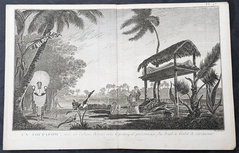
1778 Capt Cook Antique Print of Manao tupapau or Spirit Watching in Tahiti, 1773
- Title : Un Toupapow, avec un Cadavre dessus avec le principal personnage du deuil en habit de Ceremonie (Manao tupapau Ceremony with a corpse top with the main character of the mourning ceremony dress)
- Size: 15in x 10in (380mm x 255mm)
- Ref #: 21652
- Date : 1774
- Condition: (A+) Fine Condition
Description:
This large original copper-plate engraved antique print of the Spirit of the Dead Watching (Manao tupapau) in Tahiti with priest and mourners, visited by Captain James Cook in 1773, during his 2nd Voyage of Discovery to the South Seas, was engraved by Robert Benard - after William Hodges - and was published in the 1778 French edition of Capt. James Cooks 2nd Voyage of Discovery to the South Seas A voyage towards the South Pole, and round the World. Performed in His Majestys ships the Resolution and Adventure, in the years 1772, 1773, 1774, and 1775..... Paris : Hotel de Thou ......1778.
Ghosts in Polynesian culture
There was widespread belief in ghosts in Polynesian culture, some of which persists today. After death, a person\'s ghost would normally travel to the sky world or the underworld, but some could stay on earth. In many Polynesian legends, ghosts were often involved in the affairs of the living. Ghosts might also cause sickness or even invade the body of ordinary people, to be driven out through strong medicines.
In the reconstructed Proto-Polynesian language, the word qaitu refers to a ghost, the spirit of a dead person, while the word tupuqa has a broader meaning including all supernatural beings. Some of the ancient Māui legends that are common throughout the Polynesian islands include the idea of a double soul inhabiting the body. One was the soul which never forsakes man, and the other the soul that could be separated or charmed away from the body by incantations was the hau.
In some societies, the tattoo marks on the Polynesian\'s face indicated their cult. A spiral symbol meant that the man favoured the sky world, but before ascending there on a whirlwind his ghost had to travel to his people\'s homeland, situated in the navel of the world. Different markings indicated that the ghost chose to live in the underworld. The Hawaiians believed in aumakua, ghosts who did not go down into Po, the land of King Milu. These ghosts remained in the land of the living, guarding their former families.
Of his 1892 Tahitian painting Manao Tupapau, Paul Gauguin said according to Tahitian beliefs, the title Manao Tupapau has a double meaning . . . either she thinks of the ghost or the ghost thinks of her.
General Definitions:
Paper thickness and quality: - Heavy and stable
Paper color : - off white
Age of map color: -
Colors used: -
General color appearance: -
Paper size: - 15in x 10in (380mm x 255mm)
Plate size: - 15in x 9 1/2in (380mm x 245mm)
Margins: - Min 1/2in (12mm)
Imperfections:
Margins: - None
Plate area: - None
Verso: - None
Background:
Tahiti previously also known as Otaheite is the largest island in the Windward group of French Polynesia. The island is located in the archipelago of the Society Islands in the central Southern Pacific Ocean.
The first European to have visited Tahiti according to existing records was lieutenant Samuel Wallis, who was circumnavigating the globe in HMS Dolphin, sighting the island on 18 June 1767, and eventually harboring in Matavai Bay. This bay was situated on the territory of the chiefdom of Pare-Arue, governed by Tu (Tu-nui-e-a a-i-te-Atua) and his regent Tutaha, and the chiefdom of Ha apape, governed by Amo and his wife Oberea (Purea). Wallis named the island King Georges Island. The first contacts were difficult, since on the 24 and 26 June 1767, Tahitian warriors in canoes showed aggression towards the British, hurling stones from their slings. In retaliation, the British sailors opened fire on the warriors in the canoes and on the hills. In reaction to this powerful counter-attack, the Tahitians laid down peace offerings for the British. Following this episode, Samuel Wallis was able to establish cordial relations with the female chieftain “Oberea “ (Purea) and remained on the island until 27 July 1767.
In July 1768, Captain James Cook was commissioned by the Royal Society and on orders from the Lords Commissioners of the Admiralty to observe the transit of Venus across the sun, a phenomenon that would be visible from Tahiti on 3 June 1769. He arrived in Tahitis Matavai Bay, commanding the HMS Endeavour on 12 April 1769. On 14 April, Cook met with Tutaha and Tepau. On 15 April, Cook picked the site for a fortified camp at Point Venus along with Banks, Parkinson, Daniel Solander, to protect Charles Greens observatory. The length of stay enabled them to undertake for the first time real ethnographic and scientific observations of the island. Assisted by the botanist Joseph Banks, and by the artist Sydney Parkinson, Cook gathered valuable information on the fauna and flora, as well as the native society, language and customs, including the proper name of the island, Otaheite. On 28 April, Cook met Purea and Tupaia, and Tupaia befriended Banks following the transit. On 21 June, Amo visited Cook, and then on 25 June, Pohuetea visited, signifying another chief seeking to ally himself with the British.
Cook and Banks circumnavigated the island from 26 June to 1 July. On the exploration, they met Ahio, chief of Ha apaiano o or Papenoo, Rita, chief of Hitia a, Pahairro, chief of Pueu, Vehiatua, chief of Tautra, Matahiapo, chief of Teahupo o, Tutea, chief of Vaira o, and Moe, chief of Afa Ahiti. In Papara, guided by Tupaia, they investigated the ruins of Mahaiatea marae, an impressive structure containing a stone pyramid or ahu, measuring 44 feet high, 267 feet long and 87 feet wide. Cook and the Endeavour departed Tahiti on 13 July 1769, taking Raiatean navigator Tupaia along for his geographic knowledge of the islands.
Cook returned to Tahiti between 15 August and 1 September 1773, greeted by the chiefs Tai and Puhi, besides the youg ari i Vehiatua II and his stepfather Ti itorea. Cook anchored in Vaitepiha Bay before returning to Point Venus where he met Tu, the paramount chief. Cook picked up two passengers from Tahiti during this trip, Porea and Mai, with Hitihiti later replacing Porea when Cook stopped at Raiatea. Cook took Hitihiti to Tahiti on 22 April, during his return leg. Then, Cook departed Tahiti on 14 May 1774.
During his final visit, Cook returned Mai to Tahiti on 12 Aug. 1777, after Mais long visit in England. Cook also brought two Maori from Queen Charlotte Sound, Te Weherua and Koa. Cook first harbored in Vaitepiha Bay, where he visited Vehiatua II s funeral bier and the prefabricated Spanish mission house. Cook also met Vehiatua III, and inscribed on the back of the Spanish cross, Georgius tertius Rex Annis 1767, 69, 73, 74 & 77, as a counterpoint to Christus Vincit Carolus III imperat 1774 on the front. On 23 Aug., Cook sailed for Matavai Bay, where he met Tu, his father Teu, his mother Tetupaia, his brothers Ari ipaea and Vaetua, and his sisters Ari ipaea-vahine, Tetua-te-ahamai, and Auo. Cook also observed a human sacrifice, taata tapu, at the Utu-ai-mahurau marae, and 49 skulls from previous victims.
On 29 Sept. 1777, Cook sailed for Papetoai Bay on Moorea. Cook met Mahine in an act of friendship on 3 Oct., though he was an enemy of Tu. When a goat kid was stolen on 6 Oct., Cook in a rampage, ordered the burning of houses and canoes until it was returned. Cook sailed for Huahine on 11 Oct., Raiatea on 2 Nov., and Borabora on 7 Dec.
On 26 October 1788, HMS Bounty, under the command of Captain William Bligh, landed in Tahiti with the mission of carrying Tahitian breadfruit trees (Tahitian: uru) to the Caribbean. Sir Joseph Banks, the botanist from James Cooks first expedition, had concluded that this plant would be ideal to feed the African slaves working in the Caribbean plantations at very little cost. The crew remained in Tahiti for about five months, the time needed to transplant the seedlings of the trees. Three weeks after leaving Tahiti, on 28 April 1789, the crew mutinied on the initiative of Fletcher Christian. The mutineers seized the ship and set the captain and most of those members of the crew who remained loyal to him adrift in a ships boat. A group of mutineers then went back to settle in Tahiti.
Although various explorers had refused to get involved in tribal conflicts, the mutineers from the Bounty offered their services as mercenaries and furnished arms to the family which became the Pōmare Dynasty. The chief Tū knew how to use their presence in the harbours favoured by sailors to his advantage. As a result of his alliance with the mutineers, he succeeded in considerably increasing his supremacy over the island of Tahiti.
Captain James King FRS 1750 – 1784 was an officer of the Royal Navy. He served under James Cook on his last voyage around the world, specialising in taking important astronomical readings using a sextant. After Cook died he helped lead the ships on the remainder of their course, also completing Cooks account of the voyage. He continued his career in the Navy, reaching the rank of post-captain, commanding several ships and serving in the American War of Independence.
King joined HMS Resolution as second lieutenant, sharing the duties of astronomer with Cook, taking astronomical observations on board by sextant and with Larcum Kendals timekeeper K1, to establish the Resolutions position at sea and on shore by sextant or by astronomical quadrant to establish the geographical position of salient points during the course of Cooks surveys. Thus Kings geographical positions were an important contribution to the accuracy of the various surveys carried out during the voyage and his use of the early chronometers helped prove their use at sea for calculation of Longitude. .
Following the death of Cook, King remained in the Resolution but on the death of Charles Clerke, Cooks successor, King was appointed to command HMS Discovery, the Resolutions consort, remaining in her for the rest of the voyage. After his return to England King was very much involved in the publication of the official account of Cooks third voyage, writing the third volume at Woodstock, near Oxford, where his brother Thomas was rector of St Mary Magdalene. But shortly after his return King was promoted Post-captain and appointed commander of HMS Crocodile in the English Channel.
John Webber RA 1751 – 1793 was an English artist who accompanied Captain Cook on his third Pacific expedition. He is best known for his images of Australasia, Hawaii and Alaska.
Webber was born in London, educated in Bern and studied painting at Paris.His father was Abraham Wäber, a Swiss sculptor who had moved to London, and changed his name to Webber before marrying a Mrs Mary Quant in 1744.
Webber served as official artist on James Cooks third voyage of discovery around the Pacific (1776–80) aboard HMS Resolution. At Adventure Bay in January 1777 he did drawings of A Man of Van Diemens Land and A Woman of Van Diemens Land. He also did many drawings of scenes in New Zealand and the South Sea islands. On this voyage, during which Cook lost his life in a fight in Hawaii, Webber became the first European artist to make contact with Hawaii, then called the Sandwich Islands. He made numerous watercolor landscapes of the islands of Kauai and Hawaii, and also portrayed many of the Hawaiian people.
In April 1778, Captain Cooks ships Resolution and Discovery anchored at Ship Cove, now known as Nootka Sound, Vancouver Island, Canada to refit. The crew took observations and recorded encounters with the local people. Webber made watercolour landscapes including Resolution and Discovery in Ship Cove, 1778. His drawings and paintings were engraved for British Admiraltys account of the expedition, which was published in 1784.
Back in England in 1780 Webber exhibited around 50 works at Royal Academy exhibitions between 1784 and 1792, and was elected an associate of the Royal Academy in 1785 and R.A. in 1791. Most of his work were landscapes. Sometimes figures were included as in A Party from H.M.S. Resolution shooting sea horses, which was shown at the academy in 1784, and his The Death of Captain Cook became well known through an engraving of it. Another version of this picture is in the William Dixson gallery at Sydney
Robert Bénard 1734 – 1777 was an 18th-century French engraver.
Specialized in the technique of engraving, Robert Ménard is mainly famous for having supplied a significant amount of plates (at least 1,800) to the Encyclopédie by Diderot & d Alembert from 1751.
Later, publisher Charles-Joseph Panckoucke reused many of his productions to illustrate the works of his catalog.
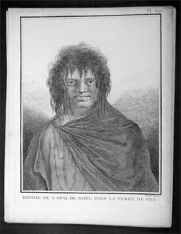
1778 Capt Cook Antique Print Portrait of a Man of Terra del Fuego, Chile in 1774
- Title : Homme du Canal de Noel Dans La Terre De Feu
- Ref : 16354
- Size: 10in x 8in (255mm x 205mm)
- Date : 1778
- Condition: (A+) Fine Condition
Description:
This fine original copper-plate engraved antique print, portrait of a Man of Christmas Sound on the S.W. Coast of Terra del Fuego Chile, visited by Captain James Cook during his 2nd Voyage of Discovery to the South Seas in December 1774, was engraved by Robert Benard - after William Hodges - and was published in the 1778 French edition of Capt. James Cooks 2nd Voyage of Discovery to the South Seas A voyage towards the South Pole, and round the World. Performed in His Majestys ships the Resolution and Adventure, in the years 1772, 1773, 1774, and 1775..... Paris : Hotel de Thou ......1778
Cook Journal
.......followed the coast of Tierra del Fuego (Chile) at the end of December 1774 making for Cape Horn. The coast comprised of hundreds of small islands, some of which were charted and named but many were not. The Resolution was kept at a safe distance from the shore and soon passed the Grafton Islands, Noir Island, Tower Rocks and the Gilbert Islands (named after the Master). On the 19th they passed a large inlet, which is now called Cook Bay. Cook needed provisions and to check the state of the Resolution,so he found an inlet suitable for this purpose on the 20th. They stayed there for eight days over Christmas, which earned the inlet the name Christmas Sound..........
General Definitions:
Paper thickness and quality: - Heavy and stable
Paper color : - off white
Age of map color: -
Colors used: -
General color appearance: -
Paper size: - 10in x 8in (255mm x 205mm)
Plate size: - 9 1/2in x 7 1/4in (240mm x 185mm)
Margins: - Min 1/2in (12mm)
Imperfections:
Margins: - Light soiling in margins
Plate area: - None
Verso: - None
Background:
Tierra del Fuego Spanish for Land of Fire is an archipelago off the southernmost tip of the South American mainland, across the Strait of Magellan. The archipelago consists of the main island, Isla Grande de Tierra del Fuego, with an area of 48,100 km2 and a group of many islands, including Cape Horn and Diego Ramírez Islands. Tierra del Fuego is divided between Chile and Argentina, with the latter controlling the eastern half of the main island and the former the western half plus the islands south of Beagle Channel.
The name Tierra del Fuego derives from the Portuguese explorer Ferdinand Magellan sailing for the Spanish Crown, in 1520 he was the first European to visit these lands. He believed he was seeing the many fires (fuego in Spanish) of the Yaghan, which were visible from the sea, and that the Indians were waiting in the forests to ambush his armada.
In 1525 Francisco de Hoces was the first to speculate that Tierra del Fuego was one or more islands rather than part of what was then called Terra Australis. Francis Drake in 1578 and a Dutch VOC expedition in 1616 learned more about the geography. The latter expedition named Cape Horn.
William Hodges RA 1744 – 1797 was an English painter. He was a member of James Cooks second voyage to the Pacific Ocean, and is best known for the sketches and paintings of locations he visited on that voyage, including Table Bay, Tahiti, Easter Island, and the Antarctic.
Between 1772 and 1775 Hodges accompanied James Cook to the Pacific as the expeditions artist. Many of his sketches and wash paintings were adapted as engravings in the original published edition of Cooks journals from the voyage.
Most of the large-scale landscape oil paintings from his Pacific travels for which Hodges is best known were finished after his return to London; he received a salary from the Admiralty for the purposes of completing them. These paintings depicted a stronger light and shadow than had been usual in European landscape tradition. Contemporary art critics complained that his use of light and colour contrasts gave his paintings a rough and unfinished appearance.
Hodges also produced many valuable portrait sketches of Pacific islanders and scenes from the voyage involving members of the expedition..
Robert Bénard 1734 – 1777 was an 18th-century French engraver.
Specialized in the technique of engraving, Robert Ménard is mainly famous for having supplied a significant amount of plates (at least 1,800) to the Encyclopédie by Diderot & d\'Alembert from 1751.
Later, publisher Charles-Joseph Panckoucke reused many of his productions to illustrate the works of his catalog.
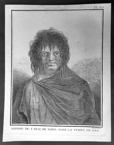
1778 Capt Cook Antique Print Portrait of a Man of Terra del Fuego, Chile in 1774
- Title : Homme du Canal de Noel Dans La Terre De Feu
- Ref : 31813
- Size: 10in x 8in (255mm x 205mm)
- Date : 1778
- Condition: (A+) Fine Condition
Description:
This fine original copper-plate engraved antique print, portrait of a Man of Christmas Sound on the S.W. Coast of Terra del Fuego Chile, visited by Captain James Cook during his 2nd Voyage of Discovery to the South Seas in December 1774, was engraved by Robert Benard - after William Hodges - and was published in the 1778 French edition of Capt. James Cooks 2nd Voyage of Discovery to the South Seas A voyage towards the South Pole, and round the World. Performed in His Majestys ships the Resolution and Adventure, in the years 1772, 1773, 1774, and 1775..... Paris : Hotel de Thou ......1778
Cook Journal
.......followed the coast of Tierra del Fuego (Chile) at the end of December 1774 making for Cape Horn. The coast comprised of hundreds of small islands, some of which were charted and named but many were not. The Resolution was kept at a safe distance from the shore and soon passed the Grafton Islands, Noir Island, Tower Rocks and the Gilbert Islands (named after the Master). On the 19th they passed a large inlet, which is now called Cook Bay. Cook needed provisions and to check the state of the Resolution,so he found an inlet suitable for this purpose on the 20th. They stayed there for eight days over Christmas, which earned the inlet the name Christmas Sound..........
General Definitions:
Paper thickness and quality: - Heavy and stable
Paper color : - off white
Age of map color: -
Colors used: -
General color appearance: -
Paper size: - 10in x 8in (255mm x 205mm)
Plate size: - 9 1/2in x 7 1/4in (240mm x 185mm)
Margins: - Min 1/2in (12mm)
Imperfections:
Margins: - Light soiling in margins
Plate area: - None
Verso: - None
Background:
Tierra del Fuego Spanish for Land of Fire is an archipelago off the southernmost tip of the South American mainland, across the Strait of Magellan. The archipelago consists of the main island, Isla Grande de Tierra del Fuego, with an area of 48,100 km2 and a group of many islands, including Cape Horn and Diego Ramírez Islands. Tierra del Fuego is divided between Chile and Argentina, with the latter controlling the eastern half of the main island and the former the western half plus the islands south of Beagle Channel.
The name Tierra del Fuego derives from the Portuguese explorer Ferdinand Magellan sailing for the Spanish Crown, in 1520 he was the first European to visit these lands. He believed he was seeing the many fires (fuego in Spanish) of the Yaghan, which were visible from the sea, and that the Indians were waiting in the forests to ambush his armada.
In 1525 Francisco de Hoces was the first to speculate that Tierra del Fuego was one or more islands rather than part of what was then called Terra Australis. Francis Drake in 1578 and a Dutch VOC expedition in 1616 learned more about the geography. The latter expedition named Cape Horn.
William Hodges RA 1744 – 1797 was an English painter. He was a member of James Cooks second voyage to the Pacific Ocean, and is best known for the sketches and paintings of locations he visited on that voyage, including Table Bay, Tahiti, Easter Island, and the Antarctic.
Between 1772 and 1775 Hodges accompanied James Cook to the Pacific as the expeditions artist. Many of his sketches and wash paintings were adapted as engravings in the original published edition of Cooks journals from the voyage.
Most of the large-scale landscape oil paintings from his Pacific travels for which Hodges is best known were finished after his return to London; he received a salary from the Admiralty for the purposes of completing them. These paintings depicted a stronger light and shadow than had been usual in European landscape tradition. Contemporary art critics complained that his use of light and colour contrasts gave his paintings a rough and unfinished appearance.
Hodges also produced many valuable portrait sketches of Pacific islanders and scenes from the voyage involving members of the expedition..
Robert Bénard 1734 – 1777 was an 18th-century French engraver.
Specialized in the technique of engraving, Robert Ménard is mainly famous for having supplied a significant amount of plates (at least 1,800) to the Encyclopédie by Diderot & d\'Alembert from 1751.
Later, publisher Charles-Joseph Panckoucke reused many of his productions to illustrate the works of his catalog.
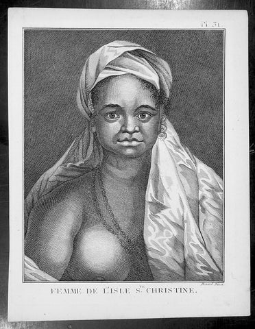
1778 Capt Cook Antique Print Portrait Princess of Tahuata, Marquesas Isles, 1774
- Title : Femme De L Isle de Ste. Christine
- Ref : 31806
- Size: 10in x 8in (255mm x 205mm)
- Date : 1778
- Condition: (A+) Fine Condition
Description:
This fine original copper-plate engraved antique print, a portrait of a Princess of Tahuata Island, Santa Cristina, in the Marquesas Islands, South Pacific, visited by Captain James Cook during his 2nd Voyage of Discovery in the South Seas in 1774, was engraved by Robert Benard - after William Hodges - and was published in the 1778 French edition of Capt. James Cooks 2nd Voyage of Discovery to the South Seas A voyage towards the South Pole, and round the World. Performed in His Majestys ships the Resolution and Adventure, in the years 1772, 1773, 1774, and 1775..... Paris : Hotel de Thou ......1778
Cook Diary (1774)
Apr. 7 Thu. Sights Hood’s Island (Fatu Huku), St. Pedro (Motare). La Dominica (Hiva Oa), St. Christina (Tahuata).
Apr 8 Fri. Sails along southern coast of Hiva Oa looking for anchorage. Anchors in Resolution (formerly Madre de Dios) Bay (Vaitahu Bay). Canoes arrive, gifts are exchanged. Natives killed after an iron stanchion is stolen.
Apr 9 Sat. Goes ashore, gifts exchanged, food obtained.
Apr 10 Sun. Goes ashore to south end of Bay and visits house of dead man. Gifts exchanged.
Apr 11 Mon. Goes ashore to south, again. Finds trade becoming expensive because of lavish gifts by his “gentlemen”.
Apr 12 Tue. Sails towards St. Dominica. No anchorage visible. Heads SW away from islands.
Apr 13 Wed. Sights last of the five main islands, Magdalena (Fatu Hiva).
General Definitions:
Paper thickness and quality: - Heavy and stable
Paper color : - off white
Age of map color: -
Colors used: -
General color appearance: -
Paper size: - 10in x 8in (255mm x 205mm)
Plate size: - 9 1/2in x 7 1/4in (240mm x 185mm)
Margins: - Min 1/2in (12mm)
Imperfections:
Margins: - Light soiling in margins
Plate area: - None
Verso: - None
Background:
Tahuata is the smallest of the inhabited Marquesas Islands, in French Polynesia, an overseas territory of France in the Pacific Ocean.
The first recorded sighting by Europeans was by the Spanish expedition of Álvaro de Mandaña on 22 July 1595. They charted the island as Santa Cristina. They landed at Vaitahu that they named Madre de Dios (Gods Mother in Spanish). According to the Spanish accounts Tahuata had fowls, fish, sugar cane, plantains, nuts and fruits. The existent town was built on two sides of a rectangular space, the houses being of timber and intertwined canes. A building which the Spaniards supposed to be a religious one stood outside the town, in a space enclosed by palisades, and containing some ill-carved images before which were offerings and provisions. The people had large and well constructed sailing canoes. Their tools were made of shells and fish bones. They used slings, stones, and lances as weapons.
Tahuata was visited by Captain James Cook in 1774 and Admiral Dupetit-Thouars in 1842, who signed the treaty annexing the Marquesas Islands to France.
The Marquesas Islands are a group of volcanic islands in French Polynesia, an overseas collective of France in the southern Pacific Ocean.
The first Europeans to reach the Marquesas may have been the crew of San Lesmes, a Spanish vessel which disappeared in a storm in June 1526; it was part of an expedition headed by García Jofre de Loaísa. The Spanish explorer Álvaro de Mendaña reached them seventy years later on 21 July 1595. He named them after his patron, García Hurtado de Mendoza, 5th Marquis of Cañete (Spanish: Marqués de Cañete), who served as Viceroy of Peru from 1590 to 1596. |Mendaña visited first Fatu Hiva and then Tahuata before continuing on to the Solomon Islands. His expedition charted the four southernmost Marquesas as Magdalena (Fatu Hiva), Dominica (Hiva ʻOa), San Pedro (Moho Tani), and Santa Cristina (Tahuata).
In the late 16th century European explorers estimated the population at more than 100,000. Europeans and Americans were impressed with how easy life appeared to be in the islands, which had a rich habitat and environment. In 1791 the American maritime fur trader Joseph Ingraham first visited the northern Marquesas while commanding the brig Hope. He named them the Washington Islands. In 1813 Commodore David Porter claimed Nuku Hiva for the United States, but the United States Congress never ratified that claim.
In 1842 France conducted a successful military operation on behalf of the native chief Iotete, who claimed he was king of the whole island of Tahuata. The government laid claim to the whole group and established a settlement on Nuku Hiva. That settlement was abandoned in 1857, but France re-established control over the group in 1870. It later incorporated the Marquesas into French Polynesia.
William Hodges RA 1744 – 1797 was an English painter. He was a member of James Cooks second voyage to the Pacific Ocean, and is best known for the sketches and paintings of locations he visited on that voyage, including Table Bay, Tahiti, Easter Island, and the Antarctic.
Between 1772 and 1775 Hodges accompanied James Cook to the Pacific as the expeditions artist. Many of his sketches and wash paintings were adapted as engravings in the original published edition of Cooks journals from the voyage.
Most of the large-scale landscape oil paintings from his Pacific travels for which Hodges is best known were finished after his return to London; he received a salary from the Admiralty for the purposes of completing them. These paintings depicted a stronger light and shadow than had been usual in European landscape tradition. Contemporary art critics complained that his use of light and colour contrasts gave his paintings a rough and unfinished appearance.
Hodges also produced many valuable portrait sketches of Pacific islanders and scenes from the voyage involving members of the expedition..
Robert Bénard 1734 – 1777 was an 18th-century French engraver.
Specialized in the technique of engraving, Robert Ménard is mainly famous for having supplied a significant amount of plates (at least 1,800) to the Encyclopédie by Diderot & d\'Alembert from 1751.
Later, publisher Charles-Joseph Panckoucke reused many of his productions to illustrate the works of his catalog.
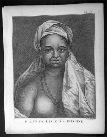
1778 Capt Cook Antique Print Portrait Princess of Tahuata, Marquesas Isles, 1774
- Title : Femme De L Isle de Ste. Christine
- Ref : 16349
- Size: 10in x 8in (255mm x 205mm)
- Date : 1778
- Condition: (A+) Fine Condition
Description:
This fine original copper-plate engraved antique print, a portrait of a Princess of Tahuata Island, Santa Cristina, in the Marquesas Islands, South Pacific, visited by Captain James Cook during his 2nd Voyage of Discovery in the South Seas in 1774, was engraved by Robert Benard - after William Hodges - and was published in the 1778 French edition of Capt. James Cooks 2nd Voyage of Discovery to the South Seas A voyage towards the South Pole, and round the World. Performed in His Majestys ships the Resolution and Adventure, in the years 1772, 1773, 1774, and 1775..... Paris : Hotel de Thou ......1778
Cook Diary (1774)
Apr. 7 Thu. Sights Hood’s Island (Fatu Huku), St. Pedro (Motare). La Dominica (Hiva Oa), St. Christina (Tahuata).
Apr 8 Fri. Sails along southern coast of Hiva Oa looking for anchorage. Anchors in Resolution (formerly Madre de Dios) Bay (Vaitahu Bay). Canoes arrive, gifts are exchanged. Natives killed after an iron stanchion is stolen.
Apr 9 Sat. Goes ashore, gifts exchanged, food obtained.
Apr 10 Sun. Goes ashore to south end of Bay and visits house of dead man. Gifts exchanged.
Apr 11 Mon. Goes ashore to south, again. Finds trade becoming expensive because of lavish gifts by his “gentlemen”.
Apr 12 Tue. Sails towards St. Dominica. No anchorage visible. Heads SW away from islands.
Apr 13 Wed. Sights last of the five main islands, Magdalena (Fatu Hiva).
General Definitions:
Paper thickness and quality: - Heavy and stable
Paper color : - off white
Age of map color: -
Colors used: -
General color appearance: -
Paper size: - 10in x 8in (255mm x 205mm)
Plate size: - 9 1/2in x 7 1/4in (240mm x 185mm)
Margins: - Min 1/2in (12mm)
Imperfections:
Margins: - Light soiling in margins
Plate area: - None
Verso: - None
Background:
Tahuata is the smallest of the inhabited Marquesas Islands, in French Polynesia, an overseas territory of France in the Pacific Ocean.
The first recorded sighting by Europeans was by the Spanish expedition of Álvaro de Mandaña on 22 July 1595. They charted the island as Santa Cristina. They landed at Vaitahu that they named Madre de Dios (Gods Mother in Spanish). According to the Spanish accounts Tahuata had fowls, fish, sugar cane, plantains, nuts and fruits. The existent town was built on two sides of a rectangular space, the houses being of timber and intertwined canes. A building which the Spaniards supposed to be a religious one stood outside the town, in a space enclosed by palisades, and containing some ill-carved images before which were offerings and provisions. The people had large and well constructed sailing canoes. Their tools were made of shells and fish bones. They used slings, stones, and lances as weapons.
Tahuata was visited by Captain James Cook in 1774 and Admiral Dupetit-Thouars in 1842, who signed the treaty annexing the Marquesas Islands to France.
The Marquesas Islands are a group of volcanic islands in French Polynesia, an overseas collective of France in the southern Pacific Ocean.
The first Europeans to reach the Marquesas may have been the crew of San Lesmes, a Spanish vessel which disappeared in a storm in June 1526; it was part of an expedition headed by García Jofre de Loaísa. The Spanish explorer Álvaro de Mendaña reached them seventy years later on 21 July 1595. He named them after his patron, García Hurtado de Mendoza, 5th Marquis of Cañete (Spanish: Marqués de Cañete), who served as Viceroy of Peru from 1590 to 1596. |Mendaña visited first Fatu Hiva and then Tahuata before continuing on to the Solomon Islands. His expedition charted the four southernmost Marquesas as Magdalena (Fatu Hiva), Dominica (Hiva ʻOa), San Pedro (Moho Tani), and Santa Cristina (Tahuata).
In the late 16th century European explorers estimated the population at more than 100,000. Europeans and Americans were impressed with how easy life appeared to be in the islands, which had a rich habitat and environment. In 1791 the American maritime fur trader Joseph Ingraham first visited the northern Marquesas while commanding the brig Hope. He named them the Washington Islands. In 1813 Commodore David Porter claimed Nuku Hiva for the United States, but the United States Congress never ratified that claim.
In 1842 France conducted a successful military operation on behalf of the native chief Iotete, who claimed he was king of the whole island of Tahuata. The government laid claim to the whole group and established a settlement on Nuku Hiva. That settlement was abandoned in 1857, but France re-established control over the group in 1870. It later incorporated the Marquesas into French Polynesia.
William Hodges RA 1744 – 1797 was an English painter. He was a member of James Cooks second voyage to the Pacific Ocean, and is best known for the sketches and paintings of locations he visited on that voyage, including Table Bay, Tahiti, Easter Island, and the Antarctic.
Between 1772 and 1775 Hodges accompanied James Cook to the Pacific as the expeditions artist. Many of his sketches and wash paintings were adapted as engravings in the original published edition of Cooks journals from the voyage.
Most of the large-scale landscape oil paintings from his Pacific travels for which Hodges is best known were finished after his return to London; he received a salary from the Admiralty for the purposes of completing them. These paintings depicted a stronger light and shadow than had been usual in European landscape tradition. Contemporary art critics complained that his use of light and colour contrasts gave his paintings a rough and unfinished appearance.
Hodges also produced many valuable portrait sketches of Pacific islanders and scenes from the voyage involving members of the expedition..
Robert Bénard 1734 – 1777 was an 18th-century French engraver.
Specialized in the technique of engraving, Robert Ménard is mainly famous for having supplied a significant amount of plates (at least 1,800) to the Encyclopédie by Diderot & d\'Alembert from 1751.
Later, publisher Charles-Joseph Panckoucke reused many of his productions to illustrate the works of his catalog.
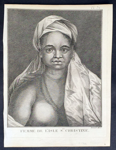
1778 Capt Cook Antique Print Portrait Princess of Tahuata, Marquesas Isles, 1774
- Title : Femme De L Isle de Ste. Christine
- Ref : 21399
- Size: 10in x 8in (255mm x 205mm)
- Date : 1778
- Condition: (A+) Fine Condition
Description:
This fine original copper-plate engraved antique print, a portrait of a Princess of Tahuata Island, Santa Cristina, in the Marquesas Islands, South Pacific, visited by Captain James Cook during his 2nd Voyage of Discovery in the South Seas in 1774, was engraved by Robert Benard - after William Hodges - and was published in the 1778 French edition of Capt. James Cooks 2nd Voyage of Discovery to the South Seas A voyage towards the South Pole, and round the World. Performed in His Majestys ships the Resolution and Adventure, in the years 1772, 1773, 1774, and 1775..... Paris : Hotel de Thou ......1778
Cook Diary (1774)
Apr. 7 Thu. Sights Hood’s Island (Fatu Huku), St. Pedro (Motare). La Dominica (Hiva Oa), St. Christina (Tahuata).
Apr 8 Fri. Sails along southern coast of Hiva Oa looking for anchorage. Anchors in Resolution (formerly Madre de Dios) Bay (Vaitahu Bay). Canoes arrive, gifts are exchanged. Natives killed after an iron stanchion is stolen.
Apr 9 Sat. Goes ashore, gifts exchanged, food obtained.
Apr 10 Sun. Goes ashore to south end of Bay and visits house of dead man. Gifts exchanged.
Apr 11 Mon. Goes ashore to south, again. Finds trade becoming expensive because of lavish gifts by his “gentlemen”.
Apr 12 Tue. Sails towards St. Dominica. No anchorage visible. Heads SW away from islands.
Apr 13 Wed. Sights last of the five main islands, Magdalena (Fatu Hiva).
General Definitions:
Paper thickness and quality: - Heavy and stable
Paper color : - off white
Age of map color: -
Colors used: -
General color appearance: -
Paper size: - 10in x 8in (255mm x 205mm)
Plate size: - 9 1/2in x 7 1/4in (240mm x 185mm)
Margins: - Min 1/2in (12mm)
Imperfections:
Margins: - Light soiling in margins
Plate area: - None
Verso: - None
Background:
Tahuata is the smallest of the inhabited Marquesas Islands, in French Polynesia, an overseas territory of France in the Pacific Ocean.
The first recorded sighting by Europeans was by the Spanish expedition of Álvaro de Mandaña on 22 July 1595. They charted the island as Santa Cristina. They landed at Vaitahu that they named Madre de Dios (Gods Mother in Spanish). According to the Spanish accounts Tahuata had fowls, fish, sugar cane, plantains, nuts and fruits. The existent town was built on two sides of a rectangular space, the houses being of timber and intertwined canes. A building which the Spaniards supposed to be a religious one stood outside the town, in a space enclosed by palisades, and containing some ill-carved images before which were offerings and provisions. The people had large and well constructed sailing canoes. Their tools were made of shells and fish bones. They used slings, stones, and lances as weapons.
Tahuata was visited by Captain James Cook in 1774 and Admiral Dupetit-Thouars in 1842, who signed the treaty annexing the Marquesas Islands to France.
The Marquesas Islands are a group of volcanic islands in French Polynesia, an overseas collective of France in the southern Pacific Ocean.
The first Europeans to reach the Marquesas may have been the crew of San Lesmes, a Spanish vessel which disappeared in a storm in June 1526; it was part of an expedition headed by García Jofre de Loaísa. The Spanish explorer Álvaro de Mendaña reached them seventy years later on 21 July 1595. He named them after his patron, García Hurtado de Mendoza, 5th Marquis of Cañete (Spanish: Marqués de Cañete), who served as Viceroy of Peru from 1590 to 1596. |Mendaña visited first Fatu Hiva and then Tahuata before continuing on to the Solomon Islands. His expedition charted the four southernmost Marquesas as Magdalena (Fatu Hiva), Dominica (Hiva ʻOa), San Pedro (Moho Tani), and Santa Cristina (Tahuata).
In the late 16th century European explorers estimated the population at more than 100,000. Europeans and Americans were impressed with how easy life appeared to be in the islands, which had a rich habitat and environment. In 1791 the American maritime fur trader Joseph Ingraham first visited the northern Marquesas while commanding the brig Hope. He named them the Washington Islands. In 1813 Commodore David Porter claimed Nuku Hiva for the United States, but the United States Congress never ratified that claim.
In 1842 France conducted a successful military operation on behalf of the native chief Iotete, who claimed he was king of the whole island of Tahuata. The government laid claim to the whole group and established a settlement on Nuku Hiva. That settlement was abandoned in 1857, but France re-established control over the group in 1870. It later incorporated the Marquesas into French Polynesia.
William Hodges RA 1744 – 1797 was an English painter. He was a member of James Cooks second voyage to the Pacific Ocean, and is best known for the sketches and paintings of locations he visited on that voyage, including Table Bay, Tahiti, Easter Island, and the Antarctic.
Between 1772 and 1775 Hodges accompanied James Cook to the Pacific as the expeditions artist. Many of his sketches and wash paintings were adapted as engravings in the original published edition of Cooks journals from the voyage.
Most of the large-scale landscape oil paintings from his Pacific travels for which Hodges is best known were finished after his return to London; he received a salary from the Admiralty for the purposes of completing them. These paintings depicted a stronger light and shadow than had been usual in European landscape tradition. Contemporary art critics complained that his use of light and colour contrasts gave his paintings a rough and unfinished appearance.
Hodges also produced many valuable portrait sketches of Pacific islanders and scenes from the voyage involving members of the expedition..
Robert Bénard 1734 – 1777 was an 18th-century French engraver.
Specialized in the technique of engraving, Robert Ménard is mainly famous for having supplied a significant amount of plates (at least 1,800) to the Encyclopédie by Diderot & d\'Alembert from 1751.
Later, publisher Charles-Joseph Panckoucke reused many of his productions to illustrate the works of his catalog.
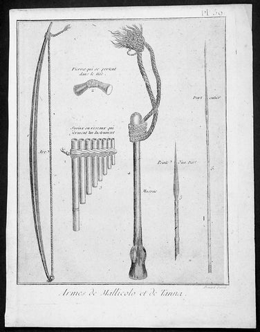
1778 Capt Cook Antique Print Weapons & Musical Instruments Vanuatu Islands, 1774
- Title : Armes de Mallicolo et de Tanna
- Ref : 91211
- Size: 10in x 8in (255mm x 205mm)
- Date : 1778
- Condition: (A+) Fine Condition
Description:
This fine original copper-plate engraved antique print of 6 different types of arms and musical instruments, from the Islands of Malakula (Mallicolo) & Tanna in the Vanuatu group of Islands in the South Pacific, visited by Captain James Cook during his 2nd Voyage of Discovery in the South Seas in September 1774, was engraved by Robert Benard - after William Hodges - and was published in the 1778 French edition of Capt. James Cooks 2nd Voyage of Discovery to the South Seas A voyage towards the South Pole, and round the World. Performed in His Majestys ships the Resolution and Adventure, in the years 1772, 1773, 1774, and 1775..... Paris : Hotel de Thou ......1778
The six objects engraved are;
1. Arc - Bow
2. Pierres qui seportent dans le nes - Stone used as a support
3. Syrinx ou roseaux quiserment un instrument - Multi tune flute
4. Massue - Club with rope attachment
5. peinte d un parl - Arrow head
6. Dart enier - Spear
Cook Journal July, 1774
Arrival at The New Hebrides
On 17th Cook saw land bearing SW and later on decided this was the Australia Del Espiritu Santo of Quiros or what M. D. Bougainville calls the Great Cyclades. The island was Maewo. The next day its northern end was rounded in a gale and the ship sailed south between it and the island called by Bougainville the Isle of Lepers - Omba.
On 20th they crossed Patteson Passage with a view of geting to the South to explore the lands which lies there, and sailed down the west coast of Pentecost Isle (Raga). To the south they saw the island of Ambrin and behind it Paama and Epi. On 22nd, approaching Mallicollo (Malekula) we perceived a creek which had the appearence of a good harbour. Cook sent Lieutt [Richard] Pickersgill and the Master [Joseph Gilbert] in two Armd boats to Sound and look for Anchorage. The following day a good many [natives] came round us, some came in Canoes and others swam off\\\'... four I took into the Cabbin and made them various presents. Later, after some misunder-standing some natives began to Shoot Arrows... a Musquet discharged in the air and a four pounder over their heads sent them all off in the utmost confusion; those in the Cabbin leaped out of the Windows... About 9 o\\\'Clock we landed in the face of about 4 or 500 Men who were assembled on the Shore, armd with Bows and Arrows, clubs and Spears, but they made not the least opposission, on the contrary one Man gave his Arms to a nother and Met us in the water with a green branch in his hand, which [he] exchanged for the one I held in my hand. Just before departing Cook remarked they have not so much as a name for a Dog, consequently can have none, for which reason we left them a Dog and a Bitch.
General Definitions:
Paper thickness and quality: - Heavy and stable
Paper color : - off white
Age of map color: -
Colors used: -
General color appearance: -
Paper size: - 10in x 8in (255mm x 205mm)
Plate size: - 9 1/2in x 7 1/4in (240mm x 185mm)
Margins: - Min 1/2in (12mm)
Imperfections:
Margins: - Light soiling in margins
Plate area: - None
Verso: - None
Background:
Malakula Island also spelled Malekula, is the second-largest island in the nation of Vanuatu, in the Pacific Ocean region of Melanesia.
Discovered by the Spanish expedition of Pedro Fernández de Quirós in 1606 and visited by Captain Cook in 1774.
Vanuatu officially the Republic of Vanuatu is a Pacific island nation located in the South Pacific Ocean. The archipelago, which is of volcanic origin, is 1,750 kilometres east of northern Australia, 540 kilometres northeast of New Caledonia, east of New Guinea, southeast of the Solomon Islands, and west of Fiji.
Vanuatu was first inhabited by Melanesian people. The first Europeans to visit the islands were a Spanish expedition led by Portuguese navigator Fernandes de Queirós, who arrived on the largest island in 1606. Since the Portuguese and Spanish monarchies had been unified under the king of Spain in 1580 (following the vacancy of the Portuguese throne, which lasted for sixty years, until 1640, when the Portuguese monarchy was restored), Queirós claimed the archipelago for Spain, as part of the colonial Spanish East Indies, and named it La Austrialia del Espiritu Santo.
The Vanuatu group of islands first had contact with Europeans in 1606, when the Portuguese explorer Pedro Fernandes de Queiros, sailing for the Spanish Crown, arrived on the largest island and called the group of islands La Austrialia del Espiritu Santo or The Southern Land of the Holy Spirit, believing he had arrived in Terra Australis or Australia. The Spanish established a short-lived settlement at Big Bay on the north side of the island. The name Espiritu Santo remains to this day.
Europeans did not return until 1768, when Louis Antoine de Bougainville rediscovered the islands on 22 May, naming them the Great Cyclades. In 1774, Captain Cook named the islands the New Hebrides, a name that would last until independence in 1980.
William Hodges RA 1744 – 1797 was an English painter. He was a member of James Cooks second voyage to the Pacific Ocean, and is best known for the sketches and paintings of locations he visited on that voyage, including Table Bay, Tahiti, Easter Island, and the Antarctic.
Between 1772 and 1775 Hodges accompanied James Cook to the Pacific as the expeditions artist. Many of his sketches and wash paintings were adapted as engravings in the original published edition of Cooks journals from the voyage.
Most of the large-scale landscape oil paintings from his Pacific travels for which Hodges is best known were finished after his return to London; he received a salary from the Admiralty for the purposes of completing them. These paintings depicted a stronger light and shadow than had been usual in European landscape tradition. Contemporary art critics complained that his use of light and colour contrasts gave his paintings a rough and unfinished appearance.
Hodges also produced many valuable portrait sketches of Pacific islanders and scenes from the voyage involving members of the expedition..
Robert Bénard 1734 – 1777 was an 18th-century French engraver.
Specialized in the technique of engraving, Robert Ménard is mainly famous for having supplied a significant amount of plates (at least 1,800) to the Encyclopédie by Diderot & d\'Alembert from 1751.
Later, publisher Charles-Joseph Panckoucke reused many of his productions to illustrate the works of his catalog.
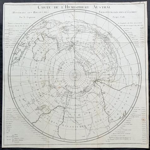
1778 Capt James Cook Antique Map The Southern Hemisphere, Australia, Antarctica
Antique Map
- Title : Carte De L Hemisphere Austral Montrant les Routes des Navigateurs les plus Celebree par le Capitaine Jacques Cook
- Ref : 42004
- Size: 22in x 21 1/2in (560mm x 545mm)
- Date : 1778
- Condition: (A) Very Good Condition
Description:
This fine original copper-plate engraved, antique map, a chart of the Southern Hemisphere, was engraved by Robert Benard and is dedicated to the discoveries in the South Seas and Antarctic Regions of Captain James Cook during his second Voyage of Discovery between 1772 & 1775. By comparison the tracks of 11 other explorers are included, from the 16th to the 18th centuries. The map by Captain James Cook was published in the 1778 French edition of A voyage towards the South Pole, and round the World. Performed in His Majestys ships the Resolution and Adventure, in the years 1772, 1773, 1774, and 1775..... Paris : Hotel de Thou ......1778
This map is unique in another way, as the English edition of this map was used as a prop, by Nathaniel Dance, in his 1776 portrait of Captain James Cook. Please also see above for the portrait.
The 11 other explorers and their tracks around the Southern Hemisphere are;
1. Mendana in 1595
2. Quiros in 1606
3. Le Maire & Schouten in 1616
4. Tasman in 1642
5. Halley in 1700
6. Roggewein in 1722
7. Bouvet in 1738-39
8. Byron in 1765
9. Wallis in 1767
10. Bougainville in 1768
11. Surville in 1769
12. Cooks first and second voyages.
General Definitions:
Paper thickness and quality: - Heavy and stable
Paper color : - off white
Age of map color: -
Colors used: -
General color appearance: -
Paper size: - 22in x 21 1/2in (560mm x 545mm)
Plate size: - 22in x 21 1/2in (560mm x 545mm)
Margins: - Min 1/2in (12mm)
Imperfections:
Margins: - Repair without loss to left of image
Plate area: - Folds as issued, light creasing along folds
Verso: - Folds as issued, light creasing along folds
Background:
This map by James Cook, was published as the premier map of his second voyage to the Southern Hemisphere, dispelling forever the myth of the Great Southern Land and showing the true cartographic nature of the southern hemisphere dominated by Australia & New Zealand. The map on a South Polar Projection also shows South America, the South Atlantic Ocean, South Africa, Madagascar, Australia - with Tasmania still joined to the mainland - New Zealand and the southern Pacific Ocean with islands.
Engraved within the explorer\\\'s tracks are the dates of their voyages and ships tracks are particularly noted around the Antarctic Circle with notations of ice fields seen during the voyages.
John Hawkesworth An English writer and journalist, Hawkesworth was commissioned by the British Admiralty to edit for publication the narratives of its officers’ circumnavigations. He was given full access to the journals of the commanders and the freedom to adapt and re-tell them in the first person. Cook was already on his way back from his second Pacific voyage, temporarily docked at Cape Town (South Africa), when he first saw the published volumes: he was mortified and furious to find that Hawkesworth claimed in the introduction that Cook had seen and blessed (with slight corrections) the resulting manuscript. (In his defense, Hawkesworth also had been a victim of misunderstanding.) Cook had trouble recognizing himself. Moreover, the work was full of errors and commentary introduced by Hawkesworth and, in Cook’s view, too full of Banks, who had promoted himself and the publication. Still, the work was popular; the first edition sold out in several months.
Robert Bénard 1734 – 1777 was an 18th-century French engraver.
Specialized in the technique of engraving, Robert Ménard is mainly famous for having supplied a significant amount of plates (at least 1,800) to the Encyclopédie by Diderot & d Alembert from 1751.
Later, publisher Charles-Joseph Panckoucke reused many of his productions to illustrate the works of his catalog.
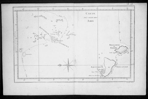
1778 Capt. Cook Antique Map HMS Resolution & Adventure in the Tonga Islands 1773
- Title : Carte Des Isles Des Amis ( Friendly Islands)
- Ref : 21764
- Size: 15 1/2in x 10in (395mm x 255mm)
- Date : 1778
- Condition: (A) Very Good Condition
Description:
This fine original copper-plate engraved antique map of the Tonga Islands with the routes taken by HMS Resolution & Adventure, during Captain James Cooks 2nd Voyage of Discovery in 1773, was engraved by Robert Benard - after Thomas Bowen - and was published in the 1778 French edition of Capt. James Cooks 2nd Voyage of Discovery to the South Seas A voyage towards the South Pole, and round the World. Performed in His Majestys ships the Resolution and Adventure, in the years 1772, 1773, 1774, and 1775..... Paris : Hotel de Thou ......1778.
Exert From Cooks diary A Voyage Towards the South Pole.........after leaving Raiatea (Society Islands) on 18 September 1773, Cook directed his course towards Amsterdam Island (Tongatapu), discovered by Tasman in 1643, intending to verify Tasmans charting against his own charts. The ships stayed for three days, thoroughly enjoying the reception they had received and called the group the Friendly Islands. On his second visit he headed for the Nomuka, the largest island of the south central group of Tonga.......
General Definitions:
Paper thickness and quality: - Heavy and stable
Paper color : - off white
Age of map color: -
Colors used: -
General color appearance: -
Paper size: - 15 1/2in x 10in (395mm x 255mm)
Plate size: - 13 1/2in x 9in (345mm x 230mm)
Margins: - Min 1/2in (12mm)
Imperfections:
Margins: - None
Plate area: - None
Verso: - None
Background:
Tonga officially the Kingdom of Tonga, is a Polynesian sovereign state and archipelago comprising 169 islands, of which 36 are inhabited. The total surface area is about 750 square kilometres (290 sq mi) scattered over 700,000 square kilometres (270,000 sq mi) of the southern Pacific Ocean. It has a population of 107,122 people, of whom 70% reside on the main island of Tongatapu.
The Tongan people first encountered Europeans in 1616 when the Dutch vessel Eendracht, captained by Willem Schouten, made a short visit to trade. Later came other Dutch explorers, including Jacob Le Maire (who called on the northern island of Niuatoputapu); and in 1643 Abel Tasman (who visited Tongatapu and Haapai).
Later noteworthy European visitors included James Cook (Royal Navy) in 1773, 1774, and 1777; Alessandro Malaspina (Spanish Navy) in 1793; the first London missionaries in 1797; and the Wesleyan Methodist Reverend Walter Lawry in 1822.
Tonga became known in the West as the Friendly Islands because of the congenial reception accorded to Captain James Cook on his first visit in 1773. He arrived at the time of the inasi festival, the yearly donation of the First Fruits to the Tui Tonga (the islands paramount chief) and so received an invitation to the festivities. According to the writer William Mariner, the chiefs wanted to kill Cook during the gathering but could not agree on a plan.
William Hodges RA 1744 – 1797 was an English painter. He was a member of James Cooks second voyage to the Pacific Ocean, and is best known for the sketches and paintings of locations he visited on that voyage, including Table Bay, Tahiti, Easter Island, and the Antarctic.
Between 1772 and 1775 Hodges accompanied James Cook to the Pacific as the expeditions artist. Many of his sketches and wash paintings were adapted as engravings in the original published edition of Cooks journals from the voyage.
Most of the large-scale landscape oil paintings from his Pacific travels for which Hodges is best known were finished after his return to London; he received a salary from the Admiralty for the purposes of completing them. These paintings depicted a stronger light and shadow than had been usual in European landscape tradition. Contemporary art critics complained that his use of light and colour contrasts gave his paintings a rough and unfinished appearance.
Hodges also produced many valuable portrait sketches of Pacific islanders and scenes from the voyage involving members of the expedition..
Robert Bénard 1734 – 1777 was an 18th-century French engraver.
Specialized in the technique of engraving, Robert Ménard is mainly famous for having supplied a significant amount of plates (at least 1,800) to the Encyclopédie by Diderot & d\'Alembert from 1751.
Later, publisher Charles-Joseph Panckoucke reused many of his productions to illustrate the works of his catalog.
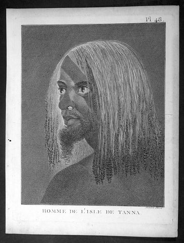
1778 Capt. Cook Antique Print of a Man of the Tanna Island, Vanuatu in 1774
- Title : Homme De L Isle de Tanna
- Ref : 16344-1
- Size: 10in x 8in (255mm x 205mm)
- Date : 1778
- Condition: (A+) Fine Condition
Description:
This fine original copper-plate engraved antique print, a portrait of a Man of the Island of Tanna in the Vanuatu group of Islands in the South Pacific, visited by Captain James Cook during his 2nd Voyage of Discovery in the South Seas in 1774, was engraved by Robert Benard - after William Hodges - and was published in the 1778 French edition of Capt. James Cooks 2nd Voyage of Discovery to the South Seas A voyage towards the South Pole, and round the World. Performed in His Majestys ships the Resolution and Adventure, in the years 1772, 1773, 1774, and 1775..... Paris : Hotel de Thou ......1778
Cook Diary, 6-20th August 1774
........the Women have all the same ornaments as Men, Nose-Stones, Earrings, Shells on the Breast & Bracelets...their heads covered with a kind of cap made of a Plantain leaf or a Mat-Basket. Few are covered, & even very young Girls have these Caps.......Cooks Journal II
General Definitions:
Paper thickness and quality: - Heavy and stable
Paper color : - off white
Age of map color: -
Colors used: -
General color appearance: -
Paper size: - 10in x 8in (255mm x 205mm)
Plate size: - 9 1/2in x 7 1/4in (240mm x 185mm)
Margins: - Min 1/2in (12mm)
Imperfections:
Margins: - Light soiling in margins
Plate area: - None
Verso: - None
Background:
Tanna (sometimes spelled Tana) is an island in Tafea Province of Vanuatu.
Tanna was first settled about 400 BC by Melanesians from the surrounding islands. The glowing light of Mount Yasur attracted James Cook, the first European to visit the island, in August 1774, where he landed in an inlet on the southeastern tip of the island that he named Port Resolution after his ship HMS Resolution. He gave the island the name of Tanna, probably from the local name for earth, tana in the Kwamera language.
Vanuatu is a Pacific island nation located in the South Pacific Ocean. The archipelago, which is of volcanic origin, is 1,750 kilometres east of northern Australia, 540 kilometres northeast of New Caledonia, east of New Guinea, southeast of the Solomon Islands, and west of Fiji.
The Vanuatu group of islands first had contact with Europeans in 1606, when the Portuguese explorer Pedro Fernandes de Queirós, sailing for the Spanish Crown, arrived on the largest island and called the group of islands La Austrialia del Espiritu Santo or The Southern Land of the Holy Spirit, believing he had arrived in Terra Australis or Australia. The Spanish established a short-lived settlement at Big Bay on the north side of the island. The name Espiritu Santo remains to this day.
Europeans did not return until 1768, when Louis Antoine de Bougainville rediscovered the islands on 22 May, naming them the Great Cyclades. In 1774, Captain Cook named the islands the New Hebrides, a name that would last until independence in 1980.
William Hodges RA 1744 – 1797 was an English painter. He was a member of James Cooks second voyage to the Pacific Ocean, and is best known for the sketches and paintings of locations he visited on that voyage, including Table Bay, Tahiti, Easter Island, and the Antarctic.
Between 1772 and 1775 Hodges accompanied James Cook to the Pacific as the expeditions artist. Many of his sketches and wash paintings were adapted as engravings in the original published edition of Cooks journals from the voyage.
Most of the large-scale landscape oil paintings from his Pacific travels for which Hodges is best known were finished after his return to London; he received a salary from the Admiralty for the purposes of completing them. These paintings depicted a stronger light and shadow than had been usual in European landscape tradition. Contemporary art critics complained that his use of light and colour contrasts gave his paintings a rough and unfinished appearance.
Hodges also produced many valuable portrait sketches of Pacific islanders and scenes from the voyage involving members of the expedition..
Robert Bénard 1734 – 1777 was an 18th-century French engraver.
Specialized in the technique of engraving, Robert Ménard is mainly famous for having supplied a significant amount of plates (at least 1,800) to the Encyclopédie by Diderot & d\'Alembert from 1751.
Later, publisher Charles-Joseph Panckoucke reused many of his productions to illustrate the works of his catalog.
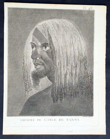
1778 Capt. Cook Antique Print of a Man of the Tanna Island, Vanuatu in 1774
- Title : Homme De L Isle de Tanna
- Ref : 21353
- Size: 10in x 8in (255mm x 205mm)
- Date : 1778
- Condition: (A+) Fine Condition
Description:
This fine original copper-plate engraved antique print, a portrait of a Man of the Island of Tanna in the Vanuatu group of Islands in the South Pacific, visited by Captain James Cook during his 2nd Voyage of Discovery in the South Seas in 1774, was engraved by Robert Benard - after William Hodges - and was published in the 1778 French edition of Capt. James Cooks 2nd Voyage of Discovery to the South Seas A voyage towards the South Pole, and round the World. Performed in His Majestys ships the Resolution and Adventure, in the years 1772, 1773, 1774, and 1775..... Paris : Hotel de Thou ......1778
Cook Diary, 6-20th August 1774
........the Women have all the same ornaments as Men, Nose-Stones, Earrings, Shells on the Breast & Bracelets...their heads covered with a kind of cap made of a Plantain leaf or a Mat-Basket. Few are covered, & even very young Girls have these Caps.......Cooks Journal II
General Definitions:
Paper thickness and quality: - Heavy and stable
Paper color : - off white
Age of map color: -
Colors used: -
General color appearance: -
Paper size: - 10in x 8in (255mm x 205mm)
Plate size: - 9 1/2in x 7 1/4in (240mm x 185mm)
Margins: - Min 1/2in (12mm)
Imperfections:
Margins: - Light soiling in margins
Plate area: - None
Verso: - None
Background:
Tanna (sometimes spelled Tana) is an island in Tafea Province of Vanuatu.
Tanna was first settled about 400 BC by Melanesians from the surrounding islands. The glowing light of Mount Yasur attracted James Cook, the first European to visit the island, in August 1774, where he landed in an inlet on the southeastern tip of the island that he named Port Resolution after his ship HMS Resolution. He gave the island the name of Tanna, probably from the local name for earth, tana in the Kwamera language.
Vanuatu is a Pacific island nation located in the South Pacific Ocean. The archipelago, which is of volcanic origin, is 1,750 kilometres east of northern Australia, 540 kilometres northeast of New Caledonia, east of New Guinea, southeast of the Solomon Islands, and west of Fiji.
The Vanuatu group of islands first had contact with Europeans in 1606, when the Portuguese explorer Pedro Fernandes de Queirós, sailing for the Spanish Crown, arrived on the largest island and called the group of islands La Austrialia del Espiritu Santo or The Southern Land of the Holy Spirit, believing he had arrived in Terra Australis or Australia. The Spanish established a short-lived settlement at Big Bay on the north side of the island. The name Espiritu Santo remains to this day.
Europeans did not return until 1768, when Louis Antoine de Bougainville rediscovered the islands on 22 May, naming them the Great Cyclades. In 1774, Captain Cook named the islands the New Hebrides, a name that would last until independence in 1980.
William Hodges RA 1744 – 1797 was an English painter. He was a member of James Cooks second voyage to the Pacific Ocean, and is best known for the sketches and paintings of locations he visited on that voyage, including Table Bay, Tahiti, Easter Island, and the Antarctic.
Between 1772 and 1775 Hodges accompanied James Cook to the Pacific as the expeditions artist. Many of his sketches and wash paintings were adapted as engravings in the original published edition of Cooks journals from the voyage.
Most of the large-scale landscape oil paintings from his Pacific travels for which Hodges is best known were finished after his return to London; he received a salary from the Admiralty for the purposes of completing them. These paintings depicted a stronger light and shadow than had been usual in European landscape tradition. Contemporary art critics complained that his use of light and colour contrasts gave his paintings a rough and unfinished appearance.
Hodges also produced many valuable portrait sketches of Pacific islanders and scenes from the voyage involving members of the expedition..
Robert Bénard 1734 – 1777 was an 18th-century French engraver.
Specialized in the technique of engraving, Robert Ménard is mainly famous for having supplied a significant amount of plates (at least 1,800) to the Encyclopédie by Diderot & d\'Alembert from 1751.
Later, publisher Charles-Joseph Panckoucke reused many of his productions to illustrate the works of his catalog.