Products
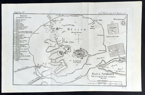
1784 Du Bocage Large Antique Map Plan of The City of Athens, Greece
- Title : Plan D Athenes...1784
- Ref #: 16460
- Size: 15 3/4in x 9 1/2in (400mm x 240mm)
- Date : 1784
- Condition: (A+) Fine Condition
Description:
This fine large original antique map a plan of Athens, Greece was engraved in 1784 - dated - and was published by Jean Denis Barbie du Bocage in his Voyage Anacharsis (The Travels of Anacharsis the Younger in Greece) publishedbetween 1781 - 1788.
Voyage Anacharsis is an illustrative account of the travels of Anacharsis the Younger in Greece, during the middle of the fourth century before the Christian era.
General Description:
Paper thickness and quality: - Heavy & stable
Paper color: - White
Age of map color: -
Colors used: -
General color appearance: -
Paper size: - 15 3/4in x 9 1/2in (400mm x 240mm)
Plate size: - 13 1/2in x 9in (350mm x 230mm)
Margins: - Min 1/2in (12mm)
Imperfections:
Margins: - None
Plate area: - Folds as issued
Verso: - None
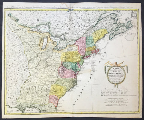
1784 Homann Large Antique Map of The Newly Formed United States of America
- Title : Charte uber die XIII vereinigte Staaten von Nord-Amerika...F L Guffefeld...A 1784
- Ref #: 61031
- Size: 23 1/4in x 19 1/4in (590mm x 490mm)
- Date : 1784
- Condition: (A) Very Good Condition
Description:
This large important & scarce fine beautifully hand coloured original antique map of the United States just after the War of Independence was engraved by F.J. Guttefeld in 1784 - dated - and published by the famous German firm of Homann Heirs.
Also known as the Stetson map, after the Stetson engraved in the title cartouche, this is one of the earliest maps to recognised the newly independent United States after the revolutionary war of Independence.
Background: An early and large map of the newly formed United States delineating all 13 states. The map extends west past the Mississippi River and north to the southern tip of Hudson Bay. The southern states are shown with their western boundaries on the Mississippi River, although the coloring shows only regions east of the Appalachians as being organized. As with many German maps of the period, there are some incorrect state boundaries; Vermont is shown as part of New Hampshire, and Maryland includes much of northern Virginia. A list of the principal German communities in New York, New Jersey and Pennsylvania are listed. The interior regions are shown with considerable topographical detail, locating numerous Indian tribes, topography, and watershed. The uncolored garland-style title cartouche is topped with a hat and crossed swords.
Each state is colored in a contrasting pastel and the states in the northern part are named by way of a lettered key given just below the attractive title cartouche. The treatment of the lands to the west of the Appalachian Mountains and up to the Mississippi River is quite interesting. This area is indicated as lands that came to the United States by the Treaty of 1783.French title outside top neat-line: Les XIII Etats Unis de l' Amerique Septentrionale. Ref: Tooley; M&B)
General Description:
Paper thickness and quality: - Heavy and stable
Paper color: - off white
Age of map color: - Original
Colors used: - Yellow, green, blue, pink
General color appearance: - Authentic
Paper size: - 23 1/4in x 19 1/4in (590mm x 490mm)
Plate size: - 23in x 18 1/4in (685mm x 465mm)
Margins: - Min 1/2in (12mm)
Imperfections:
Margins: - Light soiling in top margin,
Plate area: - Light creasing along centerfold, light soiling
Verso: - Re-enforced along centerfold

1785 Antonio Zatta Large Antique Map of Southern United States, Texas, Mexico
Antique Map
- Title : Messico ouvero Nuova Spagna che contiene Il Nuovo Messico La Californoa Con Una Partie de Paesi Adjacenti Venezi 1785
- Ref #: 93526
- Size: 21in x 15in (535mm x 385mm)
- Date : 1785
- Condition: (A+) Fine Condition
Description:
This large beautifully hand coloured original antique map of Mexico including Texas, California, and the Southern United States was engraved in 1785 - the date is engraved in the title cartouche - and was published by Antonio Zatta in his Atlas Atlante Novissimo. (Ref: Tooley; M&B)
General Definitions:
Paper thickness and quality: - Heavy and stable
Paper color : - off white
Age of map color: - Original
Colors used: - Blue, pink, red, green, yellow
General color appearance: - Authentic
Paper size: - 21in x 15in (535mm x 385mm)
Plate size: - 16in x 12 1/2in (405mm x 320mm)
Margins: - Min 1in (25mm)
Imperfections:
Margins: - None
Plate area: - None
Verso: - None
Background:
The capture of Tenochtitlan and refounding of Mexico City in 1521 was the beginning of a 286-year-long colonial era during which Mexico was known as Nueva España (New Spain). The Kingdom of New Spain was created from the remnants of the Aztec hegemonic empire. Subsequent enlargements, such as the conquest of the Tarascan state, resulted in the creation of the Viceroyalty of New Spain in 1535. The Viceroyalty at its greatest extent included the territories of modern Mexico, Central America as far south as Costa Rica, and the western United States. The Viceregal capital Mexico City also administrated the Spanish West Indies (the Caribbean), the Spanish East Indies (the Philippines), and Spanish Florida.
The indigenous population stabilized around one to one and a half million individuals in the 17th century from the most commonly accepted five to ten million pre-contact population. The population decline was primarily the result of communicable diseases, particularly smallpox, introduced during the Columbian Exchange. During the three hundred years of the colonial era, Mexico received between 400,000 and 500,000 Europeans, between 200,000 and 250,000 Africans and between 40,000 and 120,000 Asians. The 18th century saw a great increase in the percentage of mestizos.
Colonial law with Spanish roots was introduced and attached to native customs creating a hierarchy between local jurisdiction (the Cabildos) and the Spanish Crown. Upper administrative offices were closed to native-born people, even those of pure Spanish blood (criollos). Administration was based on the racial separation, among Republics of Spaniards, Amerindians and castas, autonomous and directly dependent on the king himself.
The Council of Indies and the mendicant religious orders, which arrived in Mesoamerica as early as 1524, labored to generate capital for the crown of Spain and convert the Amerindian populations to Catholicism. The 1531 Marian apparitions to Saint Juan Diego gave impetus to the evangelization of central Mexico. The Virgin of Guadalupe became a symbol of criollo patriotism and was used by the insurgents that followed Miguel Hidalgo during the War of Independence. Some Crypto-Jewish families emigrated to Mexico to escape the Spanish Inquisition.
The rich deposits of silver, particularly in Zacatecas and Guanajuato, resulted in silver extraction dominating the economy of New Spain. Taxes on silver production became a major source of income for Spain. Other important industries were the haciendas (functioning under the encomienda and repartimiento systems) and mercantile activities in the main cities and ports. Wealth created during the colonial era spurred the development of New Spanish Baroque.
As a result of its trade links with Asia, the rest of the Americas, Africa and Europe and the profound effect of New World silver, central Mexico was one of the first regions to be incorporated into a globalized economy. Being at the crossroads of trade, people and cultures, Mexico City has been called the first world city. The Nao de China (Manila Galleons) operated for two and a half centuries and connected New Spain with Asia. Goods were taken from Veracruz to Atlantic ports in the Americas and Spain. Veracruz was also the main port of entry in mainland New Spain for European goods, immigrants, and African slaves. The Camino Real de Tierra Adentro connected Mexico City with the interior of New Spain. Mexican silver pesos became the first globally used currency and the silver mined in Mexico were used to run commerce and wage crusades in two sides of globe, at the Mediterranean were Spain fought against the Ottoman Caliphate and at Southeast Asia where the Philippines fought against the Brunei Sultanate.
Due to the importance of New Spain administrative base, Mexico was the location of the first printing shop (1539), first university (1551), first public park (1592), and first public library (1646) in the Americas, amongst other institutions. Important artists of the colonial period, include the writers Juan Ruiz de Alarcón and Sor Juana Inés de la Cruz, painters Cristóbal de Villalpando and Miguel Cabrera, and architect Manuel Tolsá. The Academy of San Carlos was the first major school and museum of art in the Americas. Scientist Andrés Manuel del Río Fernández discovered the element vanadium.
Spanish forces, sometimes accompanied by native allies, led expeditions to conquer territory or quell rebellions through the colonial era. Notable Amerindian revolts in sporadically populated northern New Spain include the Chichimeca War (1576–1606), Tepehuán Revolt (1616–1620) and the Pueblo Revolt (1680). To protect Mexico from the attacks of English, French and Dutch pirates and protect the Crowns monopoly of revenue, only two ports were open to foreign trade—Veracruz on the Atlantic and Acapulco on the Pacific. Among the best-known pirate attacks are the 1663 Sack of Campeche and 1683 Attack on Veracruz.
Many Mexican cultural features including tequila, first distilled in the 16th century, charreria (17th), mariachi (18th) and Mexican cuisine, a fusion of American and European (particularly Spanish) cuisine, arose during the colonial era.
On September 16, 1810, a loyalist revolt against the ruling junta was declared by priest Miguel Hidalgo y Costilla, in the small town of Dolores, Guanajuato. This event, known as the Cry of Dolores (Spanish: Grito de Dolores) is commemorated each year, on September 16, as Mexicos independence day. The first insurgent group was formed by Hidalgo, the Spanish viceregal army captain Ignacio Allende, the militia captain Juan Aldama and La Corregidora Josefa Ortiz de Domínguez. Hidalgo and some of his soldiers were captured and executed by firing squad in Chihuahua, on July 31, 1811. Following his death, the leadership was assumed by priest José María Morelos, who occupied key southern cities.
In 1813 the Congress of Chilpancingo was convened and, on November 6, signed the Solemn Act of the Declaration of Independence of Northern America. Morelos was captured and executed on December 22, 1815.
In subsequent years, the insurgency was near collapse, but in 1820 Viceroy Juan Ruiz de Apodaca sent an army under the criollo general Agustín de Iturbide against the troops of Vicente Guerrero. Instead, Iturbide approached Guerrero to join forces, and on August 24, 1821 representatives of the Spanish Crown and Iturbide signed the Treaty of Córdoba and the Declaration of Independence of the Mexican Empire, which recognized the independence of Mexico under the terms of the Plan of Iguala.
Mexicos short recovery after the War of Independence was soon cut short again by the civil wars and institutional instability of the 1850s, which lasted until the government of Porfirio Díaz reestablished conditions that paved the way for economic growth. The conflicts that arose from the mid-1850s had a profound effect because they were widespread and made themselves perceptible in the vast rural areas of the countries, involved clashes between castes, different ethnic groups and haciendas, and entailed a deepening of the political and ideological divisions between republicans and monarchists.
Agustín de Iturbide became constitutional emperor of the First Mexican Empire in 1822. A revolt against him in 1823 established the United Mexican States. In 1824, a Republican Constitution was drafted and Guadalupe Victoria became the first president of the newly born country. Central America, including Chiapas, left the union. In 1829 president Guerrero abolished slavery. The first decades of the post-independence period were marked by economic instability, which led to the Pastry War in 1836. There was constant strife between Liberals, supporters of a federal form of government, and Conservatives, who proposed a hierarchical form of government.
During this period, the frontier borderlands to the north became quite isolated from the government in Mexico City, and its monopolistic economic policies caused suffering. With limited trade, the people had difficulty meeting tax payments and resented the central governments actions in collecting customs. Resentment built up from California to Texas. Both the mission system and the presidios had collapsed after the Spanish withdrew from the colony, causing great disruption especially in Alta California and New Mexico. The people in the borderlands had to raise local militias to protect themselves from hostile Native Americans. These areas developed in different directions from the center of the country.
Wanting to stabilize and develop the frontier, Mexico encouraged immigration into present-day Texas, as they were unable to persuade people from central Mexico to move into those areas. They allowed for religious freedom for the new settlers, who were primarily Protestant English speakers from the United States. Within several years, the Anglos far outnumbered the Tejano in the area. Itinerant traders traveled through the area, working by free market principles. The Tejano grew more separate from the government and due to its neglect, many supported the idea of independence and joined movements to that end, collaborating with the English-speaking Americans.
General Antonio López de Santa Anna, a centralist and two-time dictator, approved the Siete Leyes in 1836, a radical amendment that institutionalized the centralized form of government. When he suspended the 1824 Constitution, civil war spread across the country. Three new governments declared independence: the Republic of Texas, the Republic of the Rio Grande and the Republic of Yucatán.
The 1846 United States annexation of the Republic of Texas and subsequent American military incursion into territory that was part of Coahuila (also claimed by Texas) instigated the Mexican–American War. The war was settled in 1848 via the Treaty of Guadalupe Hidalgo. Mexico was forced to give up more than one-third of its land to the U.S., including Alta California, Santa Fe de Nuevo México and the territory claimed by Texas. A much smaller transfer of territory in what is today southern Arizona and southwestern New Mexico—known as the Gadsden Purchase—occurred in 1854.
The Caste War of Yucatán, the Maya uprising that began in 1847, was one of the most successful modern Native American revolts. Maya rebels, or Cruzob, maintained relatively independent enclaves in the peninsula until the 1930s.
Dissatisfaction with Santa Annas return to power led to the liberal Plan of Ayutla, initiating an era known as La Reforma. The new Constitution drafted in 1857 established a secular state, federalism as the form of government, and several freedoms. As the Conservatives refused to recognize it, the Reform War began in 1858, during which both groups had their own governments. The war ended in 1861 with victory by the Liberals, led by president Benito Juárez, who was an ethnic Zapotec.
In the 1860s Mexico was occupied by France, which established the Second Mexican Empire under the rule of the Habsburg Archduke Ferdinand Maximilian of Austria with support from the Roman Catholic clergy and the Conservatives. The latter switched sides and joined the Liberals. Maximilian surrendered, was tried on June 14, 1867, and was executed a few days later on June 19 in Querétaro.
Please note all items auctioned are genuine, we do not sell reproductions. A Certificate of Authenticity (COA) can be issued on request.
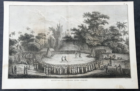
1785 Capt Cook Antique Print Cook Reception on Lifuka Island, Haapai Tonga, 1777
- Title : Reception Du Capitaine Cook a Hapaee (Reception for Captain Cook in Hapaee)
- Size: 15 1/2in x 10 1/2in (395mm x 265mm)
- Ref #: 21437
- Date : 1785
- Condition: (A+) Fine Condition
Description:
This fine original copper-plate engraved antique print of the reception for Captain Cook on the island of Lifuka, one of the islands of the Haapai group of Tonga Islands, visited by Captain Cook in 1777, during his 3rd & last Voyage of Discovery, was engraved by Robert Benard - after John Webber - and was published in the 1785 French edition of Capt. James Cook & Capt. James King publication A Voyage to the Pacific Ocean. Undertaken, by the Command of his Majesty, for making Discoveries in the Northern Hemisphere. To determine The Position and Extent of the West Side of North America; its Distance from Asia; and the Practicability of a Northern Passage to Europe. Performed under the direction of Captains Cook, Clerke, and Gore, In His Majestys Ships the Resolution and Discovery. In the Years 1776, 1777, 1778, 1779, and 1780. In Three Volumes. Vol. I and II written by James Cook, F.R.S. Vol. III by Captain James King, LL.D. and F.R.S. Paris, 1785.
Captain Cook seated with the chiefs, watching two pairs of combatants, one pair boxing, the other pair fighting with clubs within a large circle of spectators. Some men of Cook\'s company are on the left on the fringe of the crowd.
............presently after a number of men entered the Circle or Area before us, armed with Clubs made of the green branches of the Cocoanut tree, these paraded about for a few minutes and then retired the one half to one side and the other half to the other, and seated themselves before the spectators: but soon after went to single Combat, one or two steping forward from the one side and chalenging those on the other which was done more by actions than words; if the Challenge was expected, which was generally the case, each put himself in a proper attitude and began to engage and continued till one or the other gave out or their weapons were broke….there were Wristling and Boxing matches; the first were performed in the same m[an]ner as at Otahiete, and the second very little different from the method practiced in England. Cook Journals III, i, 107
General Definitions:
Paper thickness and quality: - Heavy and stable
Paper color : - off white
Age of map color: -
Colors used: -
General color appearance: -
Paper size: - 15 1/2in x 10 1/2in (395mm x 265mm)
Plate size: - 14 1/2in x 9 1/2in (370mm x 245mm)
Margins: - Min 1/2in (12mm)
Imperfections:
Margins: - Light soiling
Plate area: - None
Verso: - Light soiling
Background:
Lifuka is an island in the Kingdom of Tonga. It is located within the Haapai Group in the centre of the country, to northeast of the national capital of Nukualofa.
Lifuka is the place where Captain James Cook dubbed Tonga The Friendly Islands. Tofua is where the mutiny on the Bounty occurred in 1789; this active volcanic island lies approximately forty nautical miles west of Lifuka. The Cpt. Bligh voyage stands as the longest successful passage ever recorded in an open boat without modern navigational aids.
Haapai is a group of islands, islets, reefs and shoals with an area of 109.30 square kilometres in the central part of the Kingdom of Tonga, with the Tongatapu group to the south and the Vavau group to the north. Seventeen of the Ha apai islands are populated with altogether 6,616 people.
The first European to visit Ha apai, was Abel Tasman in 1643. Captain James Cook in 1774 and 1777, made several stops on the islands. He gave them the name of Friendly Islands in 1777.
On 18 May 1777, Cook arrived with Omai. They were greeted by Fatafehi Paulaho, King of the Isles or Tui Tonga, the most sacred chief in these islands.
Tonga officially the Kingdom of Tonga, is a Polynesian sovereign state and archipelago comprising 169 islands, of which 36 are inhabited. The total surface area is about 750 square kilometres (290 sq mi) scattered over 700,000 square kilometres (270,000 sq mi) of the southern Pacific Ocean. It has a population of 107,122 people, of whom 70% reside on the main island of Tongatapu.
The Tongan people first encountered Europeans in 1616 when the Dutch vessel Eendracht, captained by Willem Schouten, made a short visit to trade. Later came other Dutch explorers, including Jacob Le Maire (who called on the northern island of Niuatoputapu); and in 1643 Abel Tasman (who visited Tongatapu and Haapai).
Later noteworthy European visitors included James Cook (Royal Navy) in 1773, 1774, and 1777; Alessandro Malaspina (Spanish Navy) in 1793; the first London missionaries in 1797; and the Wesleyan Methodist Reverend Walter Lawry in 1822.
Tonga became known in the West as the Friendly Islands because of the congenial reception accorded to Captain James Cook on his first visit in 1773. He arrived at the time of the inasi festival, the yearly donation of the First Fruits to the Tui Tonga (the islands paramount chief) and so received an invitation to the festivities. According to the writer William Mariner, the chiefs wanted to kill Cook during the gathering but could not agree on a plan.
Captain James King FRS 1750 – 1784 was an officer of the Royal Navy. He served under James Cook on his last voyage around the world, specialising in taking important astronomical readings using a sextant. After Cook died he helped lead the ships on the remainder of their course, also completing Cooks account of the voyage. He continued his career in the Navy, reaching the rank of post-captain, commanding several ships and serving in the American War of Independence.
King joined HMS Resolution as second lieutenant, sharing the duties of astronomer with Cook, taking astronomical observations on board by sextant and with Larcum Kendals timekeeper K1, to establish the Resolutions position at sea and on shore by sextant or by astronomical quadrant to establish the geographical position of salient points during the course of Cooks surveys. Thus Kings geographical positions were an important contribution to the accuracy of the various surveys carried out during the voyage and his use of the early chronometers helped prove their use at sea for calculation of Longitude. .
Following the death of Cook, King remained in the Resolution but on the death of Charles Clerke, Cooks successor, King was appointed to command HMS Discovery, the Resolutions consort, remaining in her for the rest of the voyage. After his return to England King was very much involved in the publication of the official account of Cooks third voyage, writing the third volume at Woodstock, near Oxford, where his brother Thomas was rector of St Mary Magdalene. But shortly after his return King was promoted Post-captain and appointed commander of HMS Crocodile in the English Channel.
John Webber RA 1751 – 1793 was an English artist who accompanied Captain Cook on his third Pacific expedition. He is best known for his images of Australasia, Hawaii and Alaska.
Webber was born in London, educated in Bern and studied painting at Paris.His father was Abraham Wäber, a Swiss sculptor who had moved to London, and changed his name to Webber before marrying a Mrs Mary Quant in 1744.
Webber served as official artist on James Cooks third voyage of discovery around the Pacific (1776–80) aboard HMS Resolution. At Adventure Bay in January 1777 he did drawings of A Man of Van Diemens Land and A Woman of Van Diemens Land. He also did many drawings of scenes in New Zealand and the South Sea islands. On this voyage, during which Cook lost his life in a fight in Hawaii, Webber became the first European artist to make contact with Hawaii, then called the Sandwich Islands. He made numerous watercolor landscapes of the islands of Kauai and Hawaii, and also portrayed many of the Hawaiian people.
In April 1778, Captain Cooks ships Resolution and Discovery anchored at Ship Cove, now known as Nootka Sound, Vancouver Island, Canada to refit. The crew took observations and recorded encounters with the local people. Webber made watercolour landscapes including Resolution and Discovery in Ship Cove, 1778. His drawings and paintings were engraved for British Admiraltys account of the expedition, which was published in 1784.
Back in England in 1780 Webber exhibited around 50 works at Royal Academy exhibitions between 1784 and 1792, and was elected an associate of the Royal Academy in 1785 and R.A. in 1791. Most of his work were landscapes. Sometimes figures were included as in A Party from H.M.S. Resolution shooting sea horses, which was shown at the academy in 1784, and his The Death of Captain Cook became well known through an engraving of it. Another version of this picture is in the William Dixson gallery at Sydney
Robert Bénard 1734 – 1777 was an 18th-century French engraver.
Specialized in the technique of engraving, Robert Ménard is mainly famous for having supplied a significant amount of plates (at least 1,800) to the Encyclopédie by Diderot & d Alembert from 1751.
Later, publisher Charles-Joseph Panckoucke reused many of his productions to illustrate the works of his catalog.
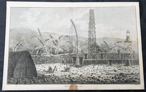
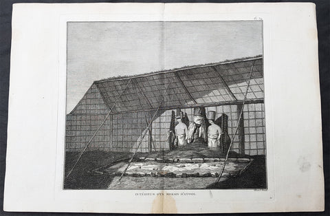
1785 Capt Cook Antique Print Interior of a Heiau, Island of Kauai Hawaii in 1778
- Title : Cimetiere D Atooi (Cemetery in Atooi)
- Size: 15 1/2in x 10in (390mm x 255mm)
- Ref #: 21441
- Date : 1785
- Condition: (A+) Fine Condition
Description:
This fine original copper-plate engraved antique print of the inside of a Hawaiian Heiau - temple - on the Island of Kauai (Atooi) Hawaii, visited by Captain Cook in 1778, during his 3rd & last Voyage of Discovery, was engraved by Robert Benard - after John Webber - and was published in the 1785 French edition of Capt. James Cook & Capt. James King publication A Voyage to the Pacific Ocean. Undertaken, by the Command of his Majesty, for making Discoveries in the Northern Hemisphere. To determine The Position and Extent of the West Side of North America; its Distance from Asia; and the Practicability of a Northern Passage to Europe. Performed under the direction of Captains Cook, Clerke, and Gore, In His Majestys Ships the Resolution and Discovery. In the Years 1776, 1777, 1778, 1779, and 1780. In Three Volumes. Vol. I and II written by James Cook, F.R.S. Vol. III by Captain James King, LL.D. and F.R.S. Paris, 1785.
Captain Cook arrived at Atooi (Kauai) on 19th January 1778 and stayed until 23rd January 1778.
On the 21st January, Cook accompanied by John Webber, proceeded inland from their beach side anchorage to Waimea, on the south coast of Kauai. Their intention was to examine elevated objects visible from the ship. It proved to be a morai, or temple similar to ones they had seen in Tahiti and other South Pacific islands. This structure was nearly 20-feet high and covered in a thin, light-grey cloth, which likely had ceremonial significance. The temple rested on a platform and consisted of thousands of rough-edged lava rock piled in a tight, mortarless fashion. In the center is the spindly-legged oracle tower, where the priest (kahuna) might seek counsel or pray. Carved figures with tapa and leaf offerings are seen outside thatched huts topped with pili, the tall grass that grew throughout the lowlands. In his journal, Cook took particular note of several stone objects he had observed:
...........about the middle of the Morai, there were three of these places in line. We were told three chiefs had been buried there, and before them was another that was oblong. This they called Tanga (taboo or kapu in Hawaiian) and gave us clearly to understand that three human sacrifices had been buried there, that is, one at the burial of each chief. Cooks Journals - January 21, 1778
General Definitions:
Paper thickness and quality: - Heavy and stable
Paper color : - off white
Age of map color: -
Colors used: -
General color appearance: -
Paper size: - 15 1/2in x 10in (390mm x 255mm)
Plate size: - 14 1/2in x 9 1/2in (370mm x 245mm)
Margins: - Min 1/2in (12mm)
Imperfections:
Margins: - Light soiling
Plate area: - None
Verso: - Light soiling
Background:
Kauai is geologically the oldest of the main Hawaiian Islands.
In 1778, Captain James Cook arrived at Waimea Bay, the first European known to have reached the Hawaiian islands. He named the archipelago after his patron the 6th Earl of Sandwich, George Montagu
Hawaii is the 50th and most recent state to have joined the United States of America, having received statehood on August 21, 1959. Hawaii is the only U.S. state located in Oceania and the only one composed entirely of islands. It is the northernmost island group in Polynesia, occupying most of an archipelago in the central Pacific Ocean. Hawaii is the only U.S. state located outside North America.
It is possible that Spanish explorers arrived in the Hawaiian Islands in the 16th century—200 years before Captain James Cook\\\'s first documented visit in 1778. Ruy López de Villalobos commanded a fleet of six ships that left Acapulco in 1542 bound for the Philippines with a Spanish sailor named Juan Gaetano aboard as pilot. Depending on the interpretation, Gaetanos reports describe an encounter with either Hawaii or the Marshall Islands. If de Villalobos crew spotted Hawaii, Gaetano would be considered the first European to see the islands. Some scholars have dismissed these claims due to a lack of credibility.
Spanish archives contain a chart that depicts islands at the same latitude as Hawaii but with a longitude ten degrees east of the islands. In this manuscript, the island of Maui is named La Desgraciada (The Unfortunate Island), and what appears to be Hawaii Island is named La Mesa (The Table). Islands resembling Kahoolawe, Lanai, and Molokai are named Los Monjes (The Monks). For two-and-a-half centuries, Spanish galleons crossed the Pacific from Mexico along a route that passed south of Hawaii on their way to Manila. The exact route was kept secret to protect the Spanish trade monopoly against competing powers.
The 1778 arrival of British explorer James Cook was the first documented contact by a European explorer with Hawaii. Cook named the archipelago as the Sandwich Islands in honor of his sponsor John Montagu, 4th Earl of Sandwich. Cook published the islands location and rendered the native name as Owyhee. This spelling lives on in Owyhee County, Idaho. It was named after three native Hawaiian members of a trapping party who went missing in that area. The Owyhee Mountains were also named for them
Cook visited the Hawaiian Islands twice. As he prepared for departure after his second visit in 1779, a quarrel ensued as Cook took temple idols and fencing as firewood and a minor chief and his men took a ship\\\'s boat. Cook abducted the King of Hawaii Island, Kalani ōpu u, and held him for ransom aboard his ship in order to gain return of Cook\\\'s boat. This tactic had worked in Tahiti and other islands. Instead, Kalani ōpu u s supporters fought back, killing Cook and four marines as Cooks party retreated along the beach to their ship. They departed without the ships boat.
Captain James King FRS 1750 – 1784 was an officer of the Royal Navy. He served under James Cook on his last voyage around the world, specialising in taking important astronomical readings using a sextant. After Cook died he helped lead the ships on the remainder of their course, also completing Cooks account of the voyage. He continued his career in the Navy, reaching the rank of post-captain, commanding several ships and serving in the American War of Independence.
King joined HMS Resolution as second lieutenant, sharing the duties of astronomer with Cook, taking astronomical observations on board by sextant and with Larcum Kendals timekeeper K1, to establish the Resolutions position at sea and on shore by sextant or by astronomical quadrant to establish the geographical position of salient points during the course of Cooks surveys. Thus Kings geographical positions were an important contribution to the accuracy of the various surveys carried out during the voyage and his use of the early chronometers helped prove their use at sea for calculation of Longitude. .
Following the death of Cook, King remained in the Resolution but on the death of Charles Clerke, Cooks successor, King was appointed to command HMS Discovery, the Resolutions consort, remaining in her for the rest of the voyage. After his return to England King was very much involved in the publication of the official account of Cooks third voyage, writing the third volume at Woodstock, near Oxford, where his brother Thomas was rector of St Mary Magdalene. But shortly after his return King was promoted Post-captain and appointed commander of HMS Crocodile in the English Channel.
John Webber RA 1751 – 1793 was an English artist who accompanied Captain Cook on his third Pacific expedition. He is best known for his images of Australasia, Hawaii and Alaska.
Webber was born in London, educated in Bern and studied painting at Paris.His father was Abraham Wäber, a Swiss sculptor who had moved to London, and changed his name to Webber before marrying a Mrs Mary Quant in 1744.
Webber served as official artist on James Cooks third voyage of discovery around the Pacific (1776–80) aboard HMS Resolution. At Adventure Bay in January 1777 he did drawings of A Man of Van Diemens Land and A Woman of Van Diemens Land. He also did many drawings of scenes in New Zealand and the South Sea islands. On this voyage, during which Cook lost his life in a fight in Hawaii, Webber became the first European artist to make contact with Hawaii, then called the Sandwich Islands. He made numerous watercolor landscapes of the islands of Kauai and Hawaii, and also portrayed many of the Hawaiian people.
In April 1778, Captain Cooks ships Resolution and Discovery anchored at Ship Cove, now known as Nootka Sound, Vancouver Island, Canada to refit. The crew took observations and recorded encounters with the local people. Webber made watercolour landscapes including Resolution and Discovery in Ship Cove, 1778. His drawings and paintings were engraved for British Admiraltys account of the expedition, which was published in 1784.
Back in England in 1780 Webber exhibited around 50 works at Royal Academy exhibitions between 1784 and 1792, and was elected an associate of the Royal Academy in 1785 and R.A. in 1791. Most of his work were landscapes. Sometimes figures were included as in A Party from H.M.S. Resolution shooting sea horses, which was shown at the academy in 1784, and his The Death of Captain Cook became well known through an engraving of it. Another version of this picture is in the William Dixson gallery at Sydney
Robert Bénard 1734 – 1777 was an 18th-century French engraver.
Specialized in the technique of engraving, Robert Ménard is mainly famous for having supplied a significant amount of plates (at least 1,800) to the Encyclopédie by Diderot & d Alembert from 1751.
Later, publisher Charles-Joseph Panckoucke reused many of his productions to illustrate the works of his catalog.
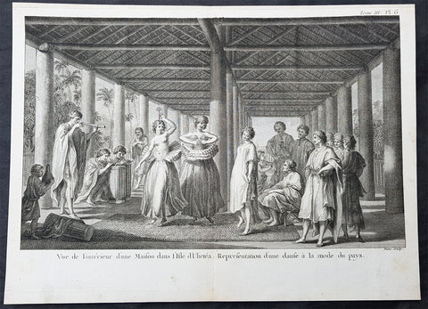
1785 Capt Cook Antique Print of Dancing Girls & Musicians Raiatea Island in 1777
- Title : Vue d L Interieur d une Maison dans i Isle d Ulietea. Representation d une danse a la mode du pays. (View of the inside a house in Isle of Ulieteai. Representation of a dance of the fashion of the country)
- Size: 14 1/2in x 9 1/2in (370mm x 245mm)
- Ref #: 16087
- Date : 1785
- Condition: (A+) Fine Condition
Description:
This fine original copper-plate engraved antique print of te interior of a long house, dancing girls and musicians on the Island of Raiatea (Ulietea) part of French Polynesia, visited by Captain Cook in 1777, during his 3rd & last Voyage of Discovery, was engraved by Robert Benard - after John Webber - and was published in the 1785 French edition of Capt. James Cook & Capt. James King publication A Voyage to the Pacific Ocean. Undertaken, by the Command of his Majesty, for making Discoveries in the Northern Hemisphere. To determine The Position and Extent of the West Side of North America; its Distance from Asia; and the Practicability of a Northern Passage to Europe. Performed under the direction of Captains Cook, Clerke, and Gore, In His Majestys Ships the Resolution and Discovery. In the Years 1776, 1777, 1778, 1779, and 1780. In Three Volumes. Vol. I and II written by James Cook, F.R.S. Vol. III by Captain James King, LL.D. and F.R.S. Paris, 1785.
Cooks Journal 1777
Sep. 29 Mon. Sails for Moorea (Eimeo).
30 Tue. Anchors at Tareu/Papetaai, Moorea.
Oct. 11 Sat. Sails for Fare, Huahine.
12 Sun. Lands at Fare and installs Omai ashore, builds house and plantation.
Nov. 2 Sun. Sails for Raiatea.
3 Mon. Anchors at Haamanino (also in July 1768 and May 1774). Sets up Observatory.
Dec. 8 Mon. Stands off Borabora but stands off and heads MS.
22 Mon. Crosses the Equator.
24 Wed. Sights Christmas Island. Anchors in atoll and collects turtles.
30 Tue. Observes eclipse of Sun (Cook Islet/Eclipse Island).
General Definitions:
Paper thickness and quality: - Heavy and stable
Paper color : - off white
Age of map color: -
Colors used: -
General color appearance: -
Paper size: - 14 1/2in x 9 1/2in (370mm x 245mm)
Plate size: - 14 1/2in x 9 1/2in (370mm x 245mm)
Margins: - Min 1/2in (12mm)
Imperfections:
Margins: - Light soiling
Plate area: - None
Verso: - Light soiling
Background:
Raiatea, is the second largest of the Society Islands, after Tahiti, in French Polynesia. The island is widely regarded as the centre of the eastern islands in ancient Polynesia and it is likely that the organised migrations to Hawaii, Aotearoa and other parts of East Polynesia started at Raiātea.
A traditional name for the island is Havaii, homeland of the Māori people.
The first European to record sighting Ra\\\\\\\'iātea was Pedro Fernandes de Queirós in 1606; it was charted as La Fugitiva The Polynesian navigator, Tupaia, who sailed with explorer James Cook, was born in Ra\\\\\\\'iātea around 1725.
Cook visited Raiatea in 1769 and again in 1773-1774. Omai (c.1751-1780), another young man from Raiātea, traveled with the European explorers to London in 1774 and also served as an interpreter to Captain Cook on his second and third journey.
King Tamatoa VI was the last monarch, reigning from 1884-1888.
Captain James King FRS 1750 – 1784 was an officer of the Royal Navy. He served under James Cook on his last voyage around the world, specialising in taking important astronomical readings using a sextant. After Cook died he helped lead the ships on the remainder of their course, also completing Cooks account of the voyage. He continued his career in the Navy, reaching the rank of post-captain, commanding several ships and serving in the American War of Independence.
King joined HMS Resolution as second lieutenant, sharing the duties of astronomer with Cook, taking astronomical observations on board by sextant and with Larcum Kendals timekeeper K1, to establish the Resolutions position at sea and on shore by sextant or by astronomical quadrant to establish the geographical position of salient points during the course of Cooks surveys. Thus Kings geographical positions were an important contribution to the accuracy of the various surveys carried out during the voyage and his use of the early chronometers helped prove their use at sea for calculation of Longitude. .
Following the death of Cook, King remained in the Resolution but on the death of Charles Clerke, Cooks successor, King was appointed to command HMS Discovery, the Resolutions consort, remaining in her for the rest of the voyage. After his return to England King was very much involved in the publication of the official account of Cooks third voyage, writing the third volume at Woodstock, near Oxford, where his brother Thomas was rector of St Mary Magdalene. But shortly after his return King was promoted Post-captain and appointed commander of HMS Crocodile in the English Channel.
John Webber RA 1751 – 1793 was an English artist who accompanied Captain Cook on his third Pacific expedition. He is best known for his images of Australasia, Hawaii and Alaska.
Webber was born in London, educated in Bern and studied painting at Paris.His father was Abraham Wäber, a Swiss sculptor who had moved to London, and changed his name to Webber before marrying a Mrs Mary Quant in 1744.
Webber served as official artist on James Cooks third voyage of discovery around the Pacific (1776–80) aboard HMS Resolution. At Adventure Bay in January 1777 he did drawings of A Man of Van Diemens Land and A Woman of Van Diemens Land. He also did many drawings of scenes in New Zealand and the South Sea islands. On this voyage, during which Cook lost his life in a fight in Hawaii, Webber became the first European artist to make contact with Hawaii, then called the Sandwich Islands. He made numerous watercolor landscapes of the islands of Kauai and Hawaii, and also portrayed many of the Hawaiian people.
In April 1778, Captain Cooks ships Resolution and Discovery anchored at Ship Cove, now known as Nootka Sound, Vancouver Island, Canada to refit. The crew took observations and recorded encounters with the local people. Webber made watercolour landscapes including Resolution and Discovery in Ship Cove, 1778. His drawings and paintings were engraved for British Admiraltys account of the expedition, which was published in 1784.
Back in England in 1780 Webber exhibited around 50 works at Royal Academy exhibitions between 1784 and 1792, and was elected an associate of the Royal Academy in 1785 and R.A. in 1791. Most of his work were landscapes. Sometimes figures were included as in A Party from H.M.S. Resolution shooting sea horses, which was shown at the academy in 1784, and his The Death of Captain Cook became well known through an engraving of it. Another version of this picture is in the William Dixson gallery at Sydney
Robert Bénard 1734 – 1777 was an 18th-century French engraver.
Specialized in the technique of engraving, Robert Ménard is mainly famous for having supplied a significant amount of plates (at least 1,800) to the Encyclopédie by Diderot & d Alembert from 1751.
Later, publisher Charles-Joseph Panckoucke reused many of his productions to illustrate the works of his catalog.
1785 Capt Cook Antique Print Statues in a Heiau, Island of Kauai Hawaii in 1778
- Title : Interieur D Un Morais D Atooi (Interior of a Morais in Atooi)
- Size: 16in x 10in (405mm x 260mm)
- Ref #: 21478
- Date : 1785
- Condition: (A+) Fine Condition
Description:
This fine original copper-plate engraved antique print of statues inside of a Hawaiian Heiau - temple - on the Island of Kauai (Atooi) Hawaii, visited by Captain Cook in 1778, during his 3rd & last Voyage of Discovery, was engraved by Robert Benard - after John Webber - and was published in the 1785 French edition of Capt. James Cook & Capt. James King publication A Voyage to the Pacific Ocean. Undertaken, by the Command of his Majesty, for making Discoveries in the Northern Hemisphere. To determine The Position and Extent of the West Side of North America; its Distance from Asia; and the Practicability of a Northern Passage to Europe. Performed under the direction of Captains Cook, Clerke, and Gore, In His Majestys Ships the Resolution and Discovery. In the Years 1776, 1777, 1778, 1779, and 1780. In Three Volumes. Vol. I and II written by James Cook, F.R.S. Vol. III by Captain James King, LL.D. and F.R.S. Paris, 1785.
Captain Cook arrived at Atooi (Kauai) on 19th January 1778 and stayed until 23rd January 1778.
On the 21st January, Cook accompanied by John Webber, proceeded inland from their beach side anchorage to Waimea, on the south coast of Kauai. Their intention was to examine elevated objects visible from the ship. It proved to be a morai, or temple similar to ones they had seen in Tahiti and other South Pacific islands. This structure was nearly 20-feet high and covered in a thin, light-grey cloth, which likely had ceremonial significance. The temple rested on a platform and consisted of thousands of rough-edged lava rock piled in a tight, mortarless fashion. In the center is the spindly-legged oracle tower, where the priest (kahuna) might seek counsel or pray. Carved figures with tapa and leaf offerings are seen outside thatched huts topped with pili, the tall grass that grew throughout the lowlands. In his journal, Cook took particular note of several stone objects he had observed:
...........about the middle of the Morai, there were three of these places in line. We were told three chiefs had been buried there, and before them was another that was oblong. This they called Tanga (taboo or kapu in Hawaiian) and gave us clearly to understand that three human sacrifices had been buried there, that is, one at the burial of each chief. Cooks Journals - January 21, 1778
General Definitions:
Paper thickness and quality: - Heavy and stable
Paper color : - off white
Age of map color: -
Colors used: -
General color appearance: -
Paper size: - 16in x 10in (405mm x 260mm)
Plate size: - 11in x 9 1/2in (280mm x 245mm)
Margins: - Min 1/2in (12mm)
Imperfections:
Margins: - Light soiling
Plate area: - None
Verso: - Light soiling
Background:
Kauai is geologically the oldest of the main Hawaiian Islands.
In 1778, Captain James Cook arrived at Waimea Bay, the first European known to have reached the Hawaiian islands. He named the archipelago after his patron the 6th Earl of Sandwich, George Montagu
Hawaii is the 50th and most recent state to have joined the United States of America, having received statehood on August 21, 1959. Hawaii is the only U.S. state located in Oceania and the only one composed entirely of islands. It is the northernmost island group in Polynesia, occupying most of an archipelago in the central Pacific Ocean. Hawaii is the only U.S. state located outside North America.
It is possible that Spanish explorers arrived in the Hawaiian Islands in the 16th century—200 years before Captain James Cook\\\'s first documented visit in 1778. Ruy López de Villalobos commanded a fleet of six ships that left Acapulco in 1542 bound for the Philippines with a Spanish sailor named Juan Gaetano aboard as pilot. Depending on the interpretation, Gaetanos reports describe an encounter with either Hawaii or the Marshall Islands. If de Villalobos crew spotted Hawaii, Gaetano would be considered the first European to see the islands. Some scholars have dismissed these claims due to a lack of credibility.
Spanish archives contain a chart that depicts islands at the same latitude as Hawaii but with a longitude ten degrees east of the islands. In this manuscript, the island of Maui is named La Desgraciada (The Unfortunate Island), and what appears to be Hawaii Island is named La Mesa (The Table). Islands resembling Kahoolawe, Lanai, and Molokai are named Los Monjes (The Monks). For two-and-a-half centuries, Spanish galleons crossed the Pacific from Mexico along a route that passed south of Hawaii on their way to Manila. The exact route was kept secret to protect the Spanish trade monopoly against competing powers.
The 1778 arrival of British explorer James Cook was the first documented contact by a European explorer with Hawaii. Cook named the archipelago as the Sandwich Islands in honor of his sponsor John Montagu, 4th Earl of Sandwich. Cook published the islands location and rendered the native name as Owyhee. This spelling lives on in Owyhee County, Idaho. It was named after three native Hawaiian members of a trapping party who went missing in that area. The Owyhee Mountains were also named for them
Cook visited the Hawaiian Islands twice. As he prepared for departure after his second visit in 1779, a quarrel ensued as Cook took temple idols and fencing as firewood and a minor chief and his men took a ship\\\'s boat. Cook abducted the King of Hawaii Island, Kalani ōpu u, and held him for ransom aboard his ship in order to gain return of Cook\\\'s boat. This tactic had worked in Tahiti and other islands. Instead, Kalani ōpu u s supporters fought back, killing Cook and four marines as Cooks party retreated along the beach to their ship. They departed without the ships boat.
Captain James King FRS 1750 – 1784 was an officer of the Royal Navy. He served under James Cook on his last voyage around the world, specialising in taking important astronomical readings using a sextant. After Cook died he helped lead the ships on the remainder of their course, also completing Cooks account of the voyage. He continued his career in the Navy, reaching the rank of post-captain, commanding several ships and serving in the American War of Independence.
King joined HMS Resolution as second lieutenant, sharing the duties of astronomer with Cook, taking astronomical observations on board by sextant and with Larcum Kendals timekeeper K1, to establish the Resolutions position at sea and on shore by sextant or by astronomical quadrant to establish the geographical position of salient points during the course of Cooks surveys. Thus Kings geographical positions were an important contribution to the accuracy of the various surveys carried out during the voyage and his use of the early chronometers helped prove their use at sea for calculation of Longitude. .
Following the death of Cook, King remained in the Resolution but on the death of Charles Clerke, Cooks successor, King was appointed to command HMS Discovery, the Resolutions consort, remaining in her for the rest of the voyage. After his return to England King was very much involved in the publication of the official account of Cooks third voyage, writing the third volume at Woodstock, near Oxford, where his brother Thomas was rector of St Mary Magdalene. But shortly after his return King was promoted Post-captain and appointed commander of HMS Crocodile in the English Channel.
John Webber RA 1751 – 1793 was an English artist who accompanied Captain Cook on his third Pacific expedition. He is best known for his images of Australasia, Hawaii and Alaska.
Webber was born in London, educated in Bern and studied painting at Paris.His father was Abraham Wäber, a Swiss sculptor who had moved to London, and changed his name to Webber before marrying a Mrs Mary Quant in 1744.
Webber served as official artist on James Cooks third voyage of discovery around the Pacific (1776–80) aboard HMS Resolution. At Adventure Bay in January 1777 he did drawings of A Man of Van Diemens Land and A Woman of Van Diemens Land. He also did many drawings of scenes in New Zealand and the South Sea islands. On this voyage, during which Cook lost his life in a fight in Hawaii, Webber became the first European artist to make contact with Hawaii, then called the Sandwich Islands. He made numerous watercolor landscapes of the islands of Kauai and Hawaii, and also portrayed many of the Hawaiian people.
In April 1778, Captain Cooks ships Resolution and Discovery anchored at Ship Cove, now known as Nootka Sound, Vancouver Island, Canada to refit. The crew took observations and recorded encounters with the local people. Webber made watercolour landscapes including Resolution and Discovery in Ship Cove, 1778. His drawings and paintings were engraved for British Admiraltys account of the expedition, which was published in 1784.
Back in England in 1780 Webber exhibited around 50 works at Royal Academy exhibitions between 1784 and 1792, and was elected an associate of the Royal Academy in 1785 and R.A. in 1791. Most of his work were landscapes. Sometimes figures were included as in A Party from H.M.S. Resolution shooting sea horses, which was shown at the academy in 1784, and his The Death of Captain Cook became well known through an engraving of it. Another version of this picture is in the William Dixson gallery at Sydney
Robert Bénard 1734 – 1777 was an 18th-century French engraver.
Specialized in the technique of engraving, Robert Ménard is mainly famous for having supplied a significant amount of plates (at least 1,800) to the Encyclopédie by Diderot & d Alembert from 1751.
Later, publisher Charles-Joseph Panckoucke reused many of his productions to illustrate the works of his catalog.
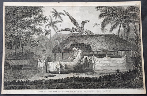
1785 Capt Cook Antique Print The Remains of Chief Vehiatua II (Tu) Tahiti, 1777
- Title : Le Corps De Thee, Chef De O Taiti, Tel Qu on le Conservoit Apres sa Mort. (The body of Thee, Chief of Tahiti Preserved after his death)
- Size: 14 1/2in x 9 1/2in (370mm x 245mm)
- Ref #: 31834
- Date : 1785
- Condition: (A) Very Good Condition
Description:
This fine original copper-plate engraved antique print of the mummified remains of Chief Vehiatua II (Tu), laying in state, on the island of Tahiti visited by Captain Cook in 1777, during his 3rd & last Voyage of Discovery, was engraved by Robert Benard - after John Webber - and was published in the 1785 French edition of Capt. James Cook & Capt. James King publication A Voyage to the Pacific Ocean. Undertaken, by the Command of his Majesty, for making Discoveries in the Northern Hemisphere. To determine The Position and Extent of the West Side of North America; its Distance from Asia; and the Practicability of a Northern Passage to Europe. Performed under the direction of Captains Cook, Clerke, and Gore, In His Majestys Ships the Resolution and Discovery. In the Years 1776, 1777, 1778, 1779, and 1780. In Three Volumes. Vol. I and II written by James Cook, F.R.S. Vol. III by Captain James King, LL.D. and F.R.S. Paris, 1785.
.....during his final visit, Cook returned Omai to Tahiti on 12 Aug. 1777, after Omais long visit in England. Cook also brought two Maori from Queen Charlotte Sound, Te Weherua and Koa. Cook first harbored in Vaitepiha Bay, where he visited Vehiatua IIs funeral bier and the prefabricated Spanish mission house. Cook also met Vehiatua III, and inscribed on the back of the Spanish cross, Georgius tertius Rex Annis 1767, 69, 73, 74 & 77, as a counterpoint to Christus Vincit Carolus III imperat 1774 on the front. On 23 Aug., Cook sailed for Matavai Bay, where he met Tu, his father Teu, his mother Tetupaia, his brothers Ariipaea and Vaetua, and his sisters Ariipaea-vahine, Tetua-te-ahamai, and Auo. Cook also observed a human sacrifice, taata tapu, at the Utu-ai-mahurau marae, and 49 skulls from previous victims....
General Definitions:
Paper thickness and quality: - Heavy and stable
Paper color : - off white
Age of map color: -
Colors used: -
General color appearance: -
Paper size: - 16in x 10 1/2in (405mm x 265mm)
Plate size: - 14 1/2in x 9 1/2in (370mm x 245mm)
Margins: - Min 1/2in (12mm)
Imperfections:
Margins: - Light soiling
Plate area: - None
Verso: - Light soiling
Background:
Tahiti previously also known as Otaheite is the largest island in the Windward group of French Polynesia. The island is located in the archipelago of the Society Islands in the central Southern Pacific Ocean.
The first European to have visited Tahiti according to existing records was lieutenant Samuel Wallis, who was circumnavigating the globe in HMS Dolphin, sighting the island on 18 June 1767, and eventually harboring in Matavai Bay. This bay was situated on the territory of the chiefdom of Pare-Arue, governed by Tu (Tu-nui-e-a a-i-te-Atua) and his regent Tutaha, and the chiefdom of Ha apape, governed by Amo and his wife Oberea (Purea). Wallis named the island King Georges Island. The first contacts were difficult, since on the 24 and 26 June 1767, Tahitian warriors in canoes showed aggression towards the British, hurling stones from their slings. In retaliation, the British sailors opened fire on the warriors in the canoes and on the hills. In reaction to this powerful counter-attack, the Tahitians laid down peace offerings for the British. Following this episode, Samuel Wallis was able to establish cordial relations with the female chieftain “Oberea “ (Purea) and remained on the island until 27 July 1767.
In July 1768, Captain James Cook was commissioned by the Royal Society and on orders from the Lords Commissioners of the Admiralty to observe the transit of Venus across the sun, a phenomenon that would be visible from Tahiti on 3 June 1769. He arrived in Tahitis Matavai Bay, commanding the HMS Endeavour on 12 April 1769. On 14 April, Cook met with Tutaha and Tepau. On 15 April, Cook picked the site for a fortified camp at Point Venus along with Banks, Parkinson, Daniel Solander, to protect Charles Greens observatory. The length of stay enabled them to undertake for the first time real ethnographic and scientific observations of the island. Assisted by the botanist Joseph Banks, and by the artist Sydney Parkinson, Cook gathered valuable information on the fauna and flora, as well as the native society, language and customs, including the proper name of the island, Otaheite. On 28 April, Cook met Purea and Tupaia, and Tupaia befriended Banks following the transit. On 21 June, Amo visited Cook, and then on 25 June, Pohuetea visited, signifying another chief seeking to ally himself with the British.
Cook and Banks circumnavigated the island from 26 June to 1 July. On the exploration, they met Ahio, chief of Ha apaiano o or Papenoo, Rita, chief of Hitia a, Pahairro, chief of Pueu, Vehiatua, chief of Tautra, Matahiapo, chief of Teahupo o, Tutea, chief of Vaira o, and Moe, chief of Afa Ahiti. In Papara, guided by Tupaia, they investigated the ruins of Mahaiatea marae, an impressive structure containing a stone pyramid or ahu, measuring 44 feet high, 267 feet long and 87 feet wide. Cook and the Endeavour departed Tahiti on 13 July 1769, taking Raiatean navigator Tupaia along for his geographic knowledge of the islands.
Cook returned to Tahiti between 15 August and 1 September 1773, greeted by the chiefs Tai and Puhi, besides the youg ari i Vehiatua II and his stepfather Ti itorea. Cook anchored in Vaitepiha Bay before returning to Point Venus where he met Tu, the paramount chief. Cook picked up two passengers from Tahiti during this trip, Porea and Mai, with Hitihiti later replacing Porea when Cook stopped at Raiatea. Cook took Hitihiti to Tahiti on 22 April, during his return leg. Then, Cook departed Tahiti on 14 May 1774.
During his final visit, Cook returned Mai to Tahiti on 12 Aug. 1777, after Mais long visit in England. Cook also brought two Maori from Queen Charlotte Sound, Te Weherua and Koa. Cook first harbored in Vaitepiha Bay, where he visited Vehiatua II s funeral bier and the prefabricated Spanish mission house. Cook also met Vehiatua III, and inscribed on the back of the Spanish cross, Georgius tertius Rex Annis 1767, 69, 73, 74 & 77, as a counterpoint to Christus Vincit Carolus III imperat 1774 on the front. On 23 Aug., Cook sailed for Matavai Bay, where he met Tu, his father Teu, his mother Tetupaia, his brothers Ari ipaea and Vaetua, and his sisters Ari ipaea-vahine, Tetua-te-ahamai, and Auo. Cook also observed a human sacrifice, taata tapu, at the Utu-ai-mahurau marae, and 49 skulls from previous victims.
On 29 Sept. 1777, Cook sailed for Papetoai Bay on Moorea. Cook met Mahine in an act of friendship on 3 Oct., though he was an enemy of Tu. When a goat kid was stolen on 6 Oct., Cook in a rampage, ordered the burning of houses and canoes until it was returned. Cook sailed for Huahine on 11 Oct., Raiatea on 2 Nov., and Borabora on 7 Dec.
On 26 October 1788, HMS Bounty, under the command of Captain William Bligh, landed in Tahiti with the mission of carrying Tahitian breadfruit trees (Tahitian: uru) to the Caribbean. Sir Joseph Banks, the botanist from James Cooks first expedition, had concluded that this plant would be ideal to feed the African slaves working in the Caribbean plantations at very little cost. The crew remained in Tahiti for about five months, the time needed to transplant the seedlings of the trees. Three weeks after leaving Tahiti, on 28 April 1789, the crew mutinied on the initiative of Fletcher Christian. The mutineers seized the ship and set the captain and most of those members of the crew who remained loyal to him adrift in a ships boat. A group of mutineers then went back to settle in Tahiti.
Although various explorers had refused to get involved in tribal conflicts, the mutineers from the Bounty offered their services as mercenaries and furnished arms to the family which became the Pōmare Dynasty. The chief Tū knew how to use their presence in the harbours favoured by sailors to his advantage. As a result of his alliance with the mutineers, he succeeded in considerably increasing his supremacy over the island of Tahiti.
Captain James King FRS 1750 – 1784 was an officer of the Royal Navy. He served under James Cook on his last voyage around the world, specialising in taking important astronomical readings using a sextant. After Cook died he helped lead the ships on the remainder of their course, also completing Cooks account of the voyage. He continued his career in the Navy, reaching the rank of post-captain, commanding several ships and serving in the American War of Independence.
King joined HMS Resolution as second lieutenant, sharing the duties of astronomer with Cook, taking astronomical observations on board by sextant and with Larcum Kendals timekeeper K1, to establish the Resolutions position at sea and on shore by sextant or by astronomical quadrant to establish the geographical position of salient points during the course of Cooks surveys. Thus Kings geographical positions were an important contribution to the accuracy of the various surveys carried out during the voyage and his use of the early chronometers helped prove their use at sea for calculation of Longitude. .
Following the death of Cook, King remained in the Resolution but on the death of Charles Clerke, Cooks successor, King was appointed to command HMS Discovery, the Resolutions consort, remaining in her for the rest of the voyage. After his return to England King was very much involved in the publication of the official account of Cooks third voyage, writing the third volume at Woodstock, near Oxford, where his brother Thomas was rector of St Mary Magdalene. But shortly after his return King was promoted Post-captain and appointed commander of HMS Crocodile in the English Channel.
John Webber RA 1751 – 1793 was an English artist who accompanied Captain Cook on his third Pacific expedition. He is best known for his images of Australasia, Hawaii and Alaska.
Webber was born in London, educated in Bern and studied painting at Paris.His father was Abraham Wäber, a Swiss sculptor who had moved to London, and changed his name to Webber before marrying a Mrs Mary Quant in 1744.
Webber served as official artist on James Cooks third voyage of discovery around the Pacific (1776–80) aboard HMS Resolution. At Adventure Bay in January 1777 he did drawings of A Man of Van Diemens Land and A Woman of Van Diemens Land. He also did many drawings of scenes in New Zealand and the South Sea islands. On this voyage, during which Cook lost his life in a fight in Hawaii, Webber became the first European artist to make contact with Hawaii, then called the Sandwich Islands. He made numerous watercolor landscapes of the islands of Kauai and Hawaii, and also portrayed many of the Hawaiian people.
In April 1778, Captain Cooks ships Resolution and Discovery anchored at Ship Cove, now known as Nootka Sound, Vancouver Island, Canada to refit. The crew took observations and recorded encounters with the local people. Webber made watercolour landscapes including Resolution and Discovery in Ship Cove, 1778. His drawings and paintings were engraved for British Admiraltys account of the expedition, which was published in 1784.
Back in England in 1780 Webber exhibited around 50 works at Royal Academy exhibitions between 1784 and 1792, and was elected an associate of the Royal Academy in 1785 and R.A. in 1791. Most of his work were landscapes. Sometimes figures were included as in A Party from H.M.S. Resolution shooting sea horses, which was shown at the academy in 1784, and his The Death of Captain Cook became well known through an engraving of it. Another version of this picture is in the William Dixson gallery at Sydney
Robert Bénard 1734 – 1777 was an 18th-century French engraver.
Specialized in the technique of engraving, Robert Ménard is mainly famous for having supplied a significant amount of plates (at least 1,800) to the Encyclopédie by Diderot & d Alembert from 1751.
Later, publisher Charles-Joseph Panckoucke reused many of his productions to illustrate the works of his catalog.
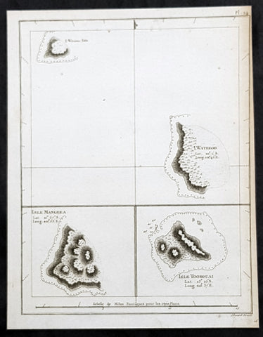
1785 Capt. Cook Antique Map 3 x Cook Islands & 1 x Society Island - Cook in 1777
- Title : I. Wenooa Ette; I. Wateeoo; Isle Mangeea; Isle Toobouai
- Size: 9 1/2in x 7 1/2in (245mm x 190mm)
- Ref #: 32164
- Date : 1785
- Condition: (A+) Fine Condition
Description:
This fine original copper-plate engraved antique map of three of the Cook Islands, Takutea (Wanooaette) Atiu (Wateeoo) and Mangaia (Mangeea) and a 4th map of the Island of Tubuai (Toobouai) in French Polynesia near Tahiti, visited by Captain Cook in HMS Resolution & Discovery in September 1777, during his 3rd & last Voyage of Discovery, was engraved by Robert Benard - after Thomas Bowen - and was published in the 1785 French edition of Capt. James Cook & Capt. James King publication A Voyage to the Pacific Ocean. Undertaken, by the Command of his Majesty, for making Discoveries in the Northern Hemisphere. To determine The Position and Extent of the West Side of North America; its Distance from Asia; and the Practicability of a Northen Passage to Europe. Performed under the direction of Captains Cook, Clerke, and Gore, In His Majesty\\\'s Ships the Resolution and Discovery. In the Years 1776, 1777, 1778, 1779, and 1780. In Three Volumes. Vol. I and II written by James Cook, F.R.S. Vol. III by Captain James King, LL.D. and F.R.S. Paris, 1785.
General Definitions:
Paper thickness and quality: - Heavy and stable
Paper color : - off white
Age of map color: -
Colors used: -
General color appearance: -
Paper size: - 9 1/2in x 7 1/2in (245mm x 190mm)
Plate size: - 9 1/2in x 7 1/2in (245mm x 190mm)
Margins: - Min 1/2in (12mm)
Imperfections:
Margins: - Bottom margin cropped into title
Plate area: - None
Verso: - None
Background:
The Cook Islands is a self-governing island country in the South Pacific Ocean in free association with New Zealand. It comprises 15 islands whose total land area is 240 square kilometres.
Spanish ships visited the islands in the 16th century; the first written record of contact with the islands came in 1595 with the sighting of Pukapuka by Spanish sailor Álvaro de Mendaña de Neira, who called it San Bernardo (Saint Bernard). Pedro Fernandes de Queirós, a Portuguese captain working for the Spanish crown, made the first recorded European landing in the islands when he set foot on Rakahanga in 1606, calling it Gente Hermosa.
British navigator Captain James Cook arrived in 1773 and 1777 and named the island of Manuae Hervey Island. Later, the name Hervey Islands came to be applied to the entire southern group; the name Cook Islands, in honour of Cook, first appeared on a Russian naval chart published in the 1820s
Takutea, in the Cook Islands, is a small uninhabited island 21 kilometres northwest of Atiu in the southern Cook Islands.
Takutea is the only island in the Cook Islands that never had a permanent population. When Captain James Cook sighted the island on 4 April 1777, and some crew members went ashore, they found some huts, but no evidence of a permanent settlement.
Atiu, also known as Enuamanu (meaning land of the birds), is an island 187 km northeast of Rarotonga, in the Southern Islands group of the Cook Islands Archipelago.
The first recorded European to arrive at Atiu was Captain Cook. He sighted the island on March 31, 1777 and made tentative contact with some of the people over the next few days.
Mangaia (traditionally known as A ua u Enua, which means terraced) is the most southerly of the Cook Islands and the second largest, after Rarotonga.
The first recorded European to arrive at Mangaia was Captain James Cook on 29 March 1777.
Tubuai part of the Society Islands is located 640 km south of Tahiti. Tubuai was first viewed by Europeans when it was mapped by Captain James Cook in 1777, although his party did not disembark. Cook discovered the islands name, Toobouai, from the natives who surrounded his ship in their canoes (a Tahitian named Omai, who was part of Cooks group, translated)
The next Europeans to arrive were the mutineers of the HMS Bounty in 1789. Mutineer Fletcher Christian, in looking for an island on which to permanently hide, had scoured Blighs maps and nautical charts and decided on Tubuai.
Upon arrival at Tubuai, a conflict arose while the mutineers were still on their ship and several islanders were killed in their canoes. The site of this event in the lagoon on the north side of the island is called Baie Sanglant (Bloody Bay)
Captain James King FRS 1750 – 1784 was an officer of the Royal Navy. He served under James Cook on his last voyage around the world, specialising in taking important astronomical readings using a sextant. After Cook died he helped lead the ships on the remainder of their course, also completing Cooks account of the voyage. He continued his career in the Navy, reaching the rank of post-captain, commanding several ships and serving in the American War of Independence.
King joined HMS Resolution as second lieutenant, sharing the duties of astronomer with Cook, taking astronomical observations on board by sextant and with Larcum Kendals timekeeper K1, to establish the Resolutions position at sea and on shore by sextant or by astronomical quadrant to establish the geographical position of salient points during the course of Cooks surveys. Thus Kings geographical positions were an important contribution to the accuracy of the various surveys carried out during the voyage and his use of the early chronometers helped prove their use at sea for calculation of Longitude. .
Following the death of Cook, King remained in the Resolution but on the death of Charles Clerke, Cooks successor, King was appointed to command HMS Discovery, the Resolutions consort, remaining in her for the rest of the voyage. After his return to England King was very much involved in the publication of the official account of Cooks third voyage, writing the third volume at Woodstock, near Oxford, where his brother Thomas was rector of St Mary Magdalene. But shortly after his return King was promoted Post-captain and appointed commander of HMS Crocodile in the English Channel.
John Webber RA 1751 – 1793 was an English artist who accompanied Captain Cook on his third Pacific expedition. He is best known for his images of Australasia, Hawaii and Alaska.
Webber was born in London, educated in Bern and studied painting at Paris.His father was Abraham Wäber, a Swiss sculptor who had moved to London, and changed his name to Webber before marrying a Mrs Mary Quant in 1744.
Webber served as official artist on James Cooks third voyage of discovery around the Pacific (1776–80) aboard HMS Resolution. At Adventure Bay in January 1777 he did drawings of A Man of Van Diemens Land and A Woman of Van Diemens Land. He also did many drawings of scenes in New Zealand and the South Sea islands. On this voyage, during which Cook lost his life in a fight in Hawaii, Webber became the first European artist to make contact with Hawaii, then called the Sandwich Islands. He made numerous watercolor landscapes of the islands of Kauai and Hawaii, and also portrayed many of the Hawaiian people.
In April 1778, Captain Cooks ships Resolution and Discovery anchored at Ship Cove, now known as Nootka Sound, Vancouver Island, Canada to refit. The crew took observations and recorded encounters with the local people. Webber made watercolour landscapes including Resolution and Discovery in Ship Cove, 1778. His drawings and paintings were engraved for British Admiraltys account of the expedition, which was published in 1784.
Back in England in 1780 Webber exhibited around 50 works at Royal Academy exhibitions between 1784 and 1792, and was elected an associate of the Royal Academy in 1785 and R.A. in 1791. Most of his work were landscapes. Sometimes figures were included as in A Party from H.M.S. Resolution shooting sea horses, which was shown at the academy in 1784, and his The Death of Captain Cook became well known through an engraving of it. Another version of this picture is in the William Dixson gallery at Sydney
Thomas Bowen (1767-1790) was an engraver and son of Emanuel Bowen, map and print seller, engraver to George II and to Louis XV of France who worked in London from 1714 producing some the best and most attractive maps of the 18th century. He had plans for completing a major County Atlas but, finding the task beyond his means, joined with Thomas Kitchin to publish “The Large English Atlas”. Many of the maps were issued individually from 1749 onwards and the whole atlas was not finally completed until 1760. With one or two exceptions they were the largest maps of the counties to appear up to that time (27” x 20”) and were unusual in that blank areas around each map are filled with historical and topographical detail which makes fascinating and amusing reading. The atlas was reissued later in reduced size. Apart from his county maps and atlases of different parts of the world he also issued (with John Owen) a book of road maps based, as was usual at that time, on Ogilby but again incorporating his own style of historical and heraldic detail. Thomas helped his father during his lifetime and produced many fine maps in his own right after his fathers death.
Robert Bénard 1734 – 1777 was an 18th-century French engraver.
Specialized in the technique of engraving, Robert Ménard is mainly famous for having supplied a significant amount of plates (at least 1,800) to the Encyclopédie by Diderot & d Alembert from 1751.
Later, publisher Charles-Joseph Panckoucke reused many of his productions to illustrate the works of his catalog.
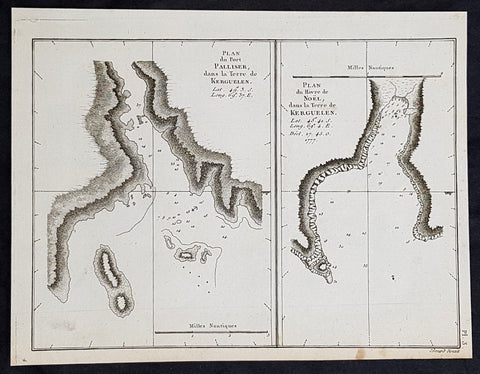
1785 Capt. Cook Antique Map of Kerguelen Island, South Indian Ocean Cook in 1776
- Title : Plan du Port Palliser dans la Terre de Kerguelen; Plan du du Havre de Noel dans la Terre de Kerguelen....1777
- Size: 9 1/2in x 7 1/2in (245mm x 190mm)
- Ref #: 32194
- Date : 1785
- Condition: (A+) Fine Condition
Description:
This fine original copper-plate engraved antique map of two maps on one sheet, the first of Port Palliser on the Island of Kerguelen and the second of Christmas Bay also located on the Island of Kerguelen in the very Southern Indian Ocean - midway between Africa, Antarctica and Australia - visited by Captain Cook in HMS Resolution & Discovery in December 25-30th 1776, during his 3rd & last Voyage of Discovery, was engraved by Robert Benard - after Thomas Bowen - and was published in the 1785 French edition of Capt. James Cook & Capt. James King publication A Voyage to the Pacific Ocean. Undertaken, by the Command of his Majesty, for making Discoveries in the Northern Hemisphere. To determine The Position and Extent of the West Side of North America; its Distance from Asia; and the Practicability of a Northen Passage to Europe. Performed under the direction of Captains Cook, Clerke, and Gore, In His Majesty\\\'s Ships the Resolution and Discovery. In the Years 1776, 1777, 1778, 1779, and 1780. In Three Volumes. Vol. I and II written by James Cook, F.R.S. Vol. III by Captain James King, LL.D. and F.R.S. Paris, 1785.
General Definitions:
Paper thickness and quality: - Heavy and stable
Paper color : - off white
Age of map color: -
Colors used: -
General color appearance: -
Paper size: - 9 1/2in x 7 1/2in (245mm x 190mm)
Plate size: - 9 1/2in x 7 1/2in (245mm x 190mm)
Margins: - Min 1/2in (12mm)
Imperfections:
Margins: - None
Plate area: - None
Verso: - None
Background:
The Kerguelen Islands, sometimes called the Desolation Islands, are located in the southern Indian Ocean and were discovered by the French navigator Yves de Kerguelen-Trémarec in 1772. On Christmas Day, 1776 Cooks ships Resolution and Discovery anchored in Oiseau Bay, which he named Christmas Harbour. Cooks men discovered a bottle containing a message in Latin left by Kerguelens men. Cook wrote in his log: I could have very properly called the island Desolation Island to signalise its sterility, but in order not to deprive M. de Kerguelen of the glory of having discovered it, I have called it Kerguelen Land.
The Kerguelen Islands or the Kerguelen Archipelago are located in the southern Indian Ocean. The main island, Grande Terre, is 6,675 km² and it is surrounded by another 300 smaller islands and islets, forming an archipelago of 7,215 km². The climate is cold and very windy and the seas are usually rough. The islands are part of a submarine large igneous province called the Kerguelen Plateau.
Captain James King FRS 1750 – 1784 was an officer of the Royal Navy. He served under James Cook on his last voyage around the world, specialising in taking important astronomical readings using a sextant. After Cook died he helped lead the ships on the remainder of their course, also completing Cooks account of the voyage. He continued his career in the Navy, reaching the rank of post-captain, commanding several ships and serving in the American War of Independence.
King joined HMS Resolution as second lieutenant, sharing the duties of astronomer with Cook, taking astronomical observations on board by sextant and with Larcum Kendals timekeeper K1, to establish the Resolutions position at sea and on shore by sextant or by astronomical quadrant to establish the geographical position of salient points during the course of Cooks surveys. Thus Kings geographical positions were an important contribution to the accuracy of the various surveys carried out during the voyage and his use of the early chronometers helped prove their use at sea for calculation of Longitude. .
Following the death of Cook, King remained in the Resolution but on the death of Charles Clerke, Cooks successor, King was appointed to command HMS Discovery, the Resolutions consort, remaining in her for the rest of the voyage. After his return to England King was very much involved in the publication of the official account of Cooks third voyage, writing the third volume at Woodstock, near Oxford, where his brother Thomas was rector of St Mary Magdalene. But shortly after his return King was promoted Post-captain and appointed commander of HMS Crocodile in the English Channel.
John Webber RA 1751 – 1793 was an English artist who accompanied Captain Cook on his third Pacific expedition. He is best known for his images of Australasia, Hawaii and Alaska.
Webber was born in London, educated in Bern and studied painting at Paris.His father was Abraham Wäber, a Swiss sculptor who had moved to London, and changed his name to Webber before marrying a Mrs Mary Quant in 1744.
Webber served as official artist on James Cooks third voyage of discovery around the Pacific (1776–80) aboard HMS Resolution. At Adventure Bay in January 1777 he did drawings of A Man of Van Diemens Land and A Woman of Van Diemens Land. He also did many drawings of scenes in New Zealand and the South Sea islands. On this voyage, during which Cook lost his life in a fight in Hawaii, Webber became the first European artist to make contact with Hawaii, then called the Sandwich Islands. He made numerous watercolor landscapes of the islands of Kauai and Hawaii, and also portrayed many of the Hawaiian people.
In April 1778, Captain Cooks ships Resolution and Discovery anchored at Ship Cove, now known as Nootka Sound, Vancouver Island, Canada to refit. The crew took observations and recorded encounters with the local people. Webber made watercolour landscapes including Resolution and Discovery in Ship Cove, 1778. His drawings and paintings were engraved for British Admiraltys account of the expedition, which was published in 1784.
Back in England in 1780 Webber exhibited around 50 works at Royal Academy exhibitions between 1784 and 1792, and was elected an associate of the Royal Academy in 1785 and R.A. in 1791. Most of his work were landscapes. Sometimes figures were included as in A Party from H.M.S. Resolution shooting sea horses, which was shown at the academy in 1784, and his The Death of Captain Cook became well known through an engraving of it. Another version of this picture is in the William Dixson gallery at Sydney
Thomas Bowen (1767-1790) was an engraver and son of Emanuel Bowen, map and print seller, engraver to George II and to Louis XV of France who worked in London from 1714 producing some the best and most attractive maps of the 18th century. He had plans for completing a major County Atlas but, finding the task beyond his means, joined with Thomas Kitchin to publish “The Large English Atlas”. Many of the maps were issued individually from 1749 onwards and the whole atlas was not finally completed until 1760. With one or two exceptions they were the largest maps of the counties to appear up to that time (27” x 20”) and were unusual in that blank areas around each map are filled with historical and topographical detail which makes fascinating and amusing reading. The atlas was reissued later in reduced size. Apart from his county maps and atlases of different parts of the world he also issued (with John Owen) a book of road maps based, as was usual at that time, on Ogilby but again incorporating his own style of historical and heraldic detail. Thomas helped his father during his lifetime and produced many fine maps in his own right after his fathers death.
Robert Bénard 1734 – 1777 was an 18th-century French engraver.
Specialized in the technique of engraving, Robert Ménard is mainly famous for having supplied a significant amount of plates (at least 1,800) to the Encyclopédie by Diderot & d Alembert from 1751.
Later, publisher Charles-Joseph Panckoucke reused many of his productions to illustrate the works of his catalog.
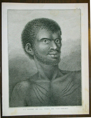
1785 Capt. Cook Antique Print Aboriginal Man of Bruny Island, Tasmania in 1777
- Title : Un Homme De La Terre De Van-Diemens
- Ref : 43195
- Size: 10in x 8in (255mm x 205mm)
- Date : 1785
- Condition: (A+) Fine Condition
Description:
This fine original copper-plate engraved antique print of an Indigenous Man of Adventure Bay, Bruny Island, Tasmania (Van Diemens Land) encountered by Captain Cook in during his 3rd & last Voyage of Discovery in 1777, was engraved by Robert Benard - after John Webber - and published in the 1785 French edition of Capt. James Cook & Capt. James King A Voyage to the Pacific Ocean. Undertaken, by the Command of his Majesty, for making Discoveries in the Northern Hemisphere. To determine The Position and Extent of the West Side of North America; its Distance from Asia; and the Practicability of a Northen Passage to Europe. Performed under the direction of Captains Cook, Clerke, and Gore, In His Majesty\'s Ships the Resolution and Discovery. In the Years 1776, 1777, 1778, 1779, and 1780. In Three Volumes. Vol. I and II written by James Cook, F.R.S. Vol. III by Captain James King, LL.D. and F.R.S. Paris, 1785.
Adventure Bay
from Cooks Journal......on the 24th (March 1777) at 3 AM we made the Coast of Van Diemen land wrote Cook. Anderson remarked that though now the middle of summer here a spot or two of snow was seen on the highest hills… At ten we passd a point supposd to be the boundary of Stone Bay where Abel Tasman anchord, i.e. Storm Bay. According to David Samwell, surgeons first mate on the Resolution, both Ships anchored in Adventure Bay in Van Diemens Land, this Bay was so called by Captn Furneaux who had anchored here in the Adventure last Voyage.
The next day Cook and Clerke sent parties, one to cut wood and the other grass. Clerke wrote of his party from the Discovery The Guard I had sent with the Parties on shore which consisted of the following Marines, Hamlet Thompson, Geo: Moody, Ben: Harriot, Jos: Pool & Willm Broom, stole some Liquor & made themselves exceedingly drunk, for which they receivd a dozen lashes each in the Morning. The Privates were all from the Plymouth division of marines. Hamlet Thompson was from the 6th Company, George Moody from the 70th, John Herriott the 12th, James Poole the 33rd and William Broom the 36th. According to Thomas Edgar, Master, they made themselves so Beastly Drunk that they were put motionless in the Boat, and when brought on board were oblig\'d to be hoisted into the Ship.
William Bayly, astronomer on the Discovery, wrote In the morning I carried my Tent observatory & Instruments on Shore & set all up, but was not able to get any observations it being cloudy all day, in the evening Capt Cook Sent for me & told me he had Altered his mind relative to his stay, & ordered me to pack all up & carry the whole on board again, as he intend[ed] to sail for New Zealand in a day or two.
John Henry Martin, seaman on the Discovery, described the natives. They have few, or no wants, & seemed perfectly Happy, if one might judge from their behaviour, for they frequently woud burst out, into the most immoderate fits of Laughter & when one Laughed every one followed his example Emediately.
General Definitions:
Paper thickness and quality: - Heavy and stable
Paper color : - off white
Age of map color: -
Colors used: -
General color appearance: -
Paper size: - 10in x 8in (255mm x 205mm)
Plate size: - 9 1/2in x 7 1/4in (240mm x 185mm)
Margins: - Min 1/2in (12mm)
Imperfections:
Margins: - None
Plate area: - None
Verso: - None
Background:
Adventure Bay is the name of both a township and a geographical feature on the eastern side of Bruny Island, Tasmania.
The first European to sight the bay was explorer Abel Tasman, who sought to anchor his vessel Heemskerck there in 1642. Instead, Heemskerck was driven back offshore by a storm, in token of which Tasman named the place Storm Bay. Captain Tobias Furneaux renamed it in March 1773, in honour of his ship HMS Adventure, which he had anchored in the bay for five days after becoming separated from Captain James Cook\'s HMS Resolution during Cook\'s second voyage to the Pacific search of Terra Australis Incognita. Furneaux\'s log made clear the bay was an excellent anchorage for resupplying vessels:....to the SW of the first watering place there is a large lagoon which I believe has plenty of fish in it for one of our Gentlemen caught upwards of 2 dozen trout, and shot a possum which was the only animal we saw. There are a great many gum trees and of a vast thickness and height, one of which measured in circumference 26 feet and the height under the branches was 20 feet.
Others among Furneaux\'s crew spotted evidence of what they believed were small deer but were more likely kangaroos. Furneaux also noted signs of an Aboriginal settlement in the form of several huts or wigwams on shore, with several bags of grass in which they carry their shellfish. - but the branches of which the huts were made were split and torn and there was not the least appearance of any people.
Reliably mapped and offering an abundance of water, fresh water and game, Adventure Bay quickly became a popular anchorage for European explorers. Cooks Resolution watered there in 1777, followed by William Bligh aboard HMS Bounty in 1788 and HMS Providence in 1792. Others who resupplied their vessels in the bay in this period included Bruni d Entrecasteaux aboard Recherché in 1792 and 1793, and Nicolas Baudin in the corvette Géographe in 1802. Matthew Flinders also tried to enter the bay with Norfolk in 1798.
John Hawkesworth 1715 – 1773 English writer and book editor.
He is said to have been clerk to an attorney, and was certainly self-educated. In 1744, he succeeded Samuel Johnson as compiler of the parliamentary debates for the Gentleman\\\'s Magazine, and from 1746 to 1749 he contributed poems signed Greville, or H Greville, to that journal. In company with Johnson and others he started a periodical called The Adventurer, which ran to 140 issues, of which 70 were from the pen of Hawkesworth himself.
On account of what was regarded as his powerful defense of morality and religion, Hawkesworth was rewarded by the archbishop of Canterbury with the degree of LL.D, In 1754–1755 he published an edition (12 vols) of Swifts works, with a life prefixed which Johnson praised in his Lives of the Poets. A larger edition (27 vols) appeared in 1766–1779. He adapted Dryden\\\'s Amphitryon for the Drury Lane stage in 1756, and Southernes Oronooko in 1759. He wrote the libretto of an oratorio Zimri in 1760, and the next year Edgar and Emmeline: a Fairy Tale was produced at Drury Lane. His Almoran and Hamet (1761) was first drafted as a play[citation needed], and a tragedy based on it by S J Pratt, The Fair Circassian (1781), met with some success.
He was commissioned by the Admiralty to edit Captain James Cooks papers relative to his first voyage. For this work, An Account of the Voyages undertaken ... for making discoveries in the Southern Hemisphere and performed by Commodore Byrone John Byron, Captain Wallis, Captain Carteret and Captain Cook (from 1702 to 1771) drawn up from the Journals ... (3 vols, 1773) Hawkesworth is said to have received from the publishers the sum of £6000. His descriptions of the manners and customs of the South Seas were, however, regarded by many critics as inexact and hurtful to the interests of morality, and the severity of their strictures is said to have hastened his death. He was buried in the parish church at Bromley, Kent, where he and his wife had kept a school.
Hawkesworth was a close imitator of Johnson both in style and thought, and was at one time on very friendly terms with him. It is said that he presumed on his success, and lost Johnsons friendship as early as 1756.
Captain James King FRS 1750 – 1784 was an officer of the Royal Navy. He served under James Cook on his last voyage around the world, specialising in taking important astronomical readings using a sextant. After Cook died he helped lead the ships on the remainder of their course, also completing Cook\\\'s account of the voyage. He continued his career in the Navy, reaching the rank of post-captain, commanding several ships and serving in the American War of Independence.
King joined HMS Resolution as second lieutenant, sharing the duties of astronomer with Cook, taking astronomical observations on board by sextant and with Larcum Kendals timekeeper K1, to establish the Resolutions position at sea and on shore by sextant or by astronomical quadrant to establish the geographical position of salient points during the course of Cooks surveys. Thus King\\\'s geographical positions were an important contribution to the accuracy of the various surveys carried out during the voyage and his use of the early chronometers helped prove their use at sea for calculation of Longitude. .
Following the death of Cook, King remained in the Resolution but on the death of Charles Clerke, Cooks successor, King was appointed to command HMS Discovery, the Resolution\\\'s consort, remaining in her for the rest of the voyage. After his return to England King was very much involved in the publication of the official account of Cooks third voyage, writing the third volume at Woodstock, near Oxford, where his brother Thomas was rector of St Mary Magdalene. But shortly after his return King was promoted Post-captain and appointed commander of HMS Crocodile in the English Channel.
John Webber RA 1751 – 1793 was an English artist who accompanied Captain Cook on his third Pacific expedition. He is best known for his images of Australasia, Hawaii and Alaska.
Webber was born in London, educated in Bern and studied painting at Paris.His father was Abraham Wäber, a Swiss sculptor who had moved to London, and changed his name to Webber before marrying a Mrs Mary Quant in 1744.
Webber served as official artist on James Cook\'s third voyage of discovery around the Pacific (1776–80) aboard HMS Resolution. At Adventure Bay in January 1777 he did drawings of A Man of Van Diemens Land and A Woman of Van Diemens Land. He also did many drawings of scenes in New Zealand and the South Sea islands. On this voyage, during which Cook lost his life in a fight in Hawaii, Webber became the first European artist to make contact with Hawaii, then called the Sandwich Islands. He made numerous watercolor landscapes of the islands of Kauai and Hawaii, and also portrayed many of the Hawaiian people.
In April 1778, Captain Cooks ships Resolution and Discovery anchored at Ship Cove, now known as Nootka Sound, Vancouver Island, Canada to refit. The crew took observations and recorded encounters with the local people. Webber made watercolour landscapes including Resolution and Discovery in Ship Cove, 1778. His drawings and paintings were engraved for British Admiraltys account of the expedition, which was published in 1784.
Back in England in 1780 Webber exhibited around 50 works at Royal Academy exhibitions between 1784 and 1792, and was elected an associate of the Royal Academy in 1785 and R.A. in 1791. Most of his work were landscapes. Sometimes figures were included as in A Party from H.M.S. Resolution shooting sea horses\", which was shown at the academy in 1784, and his The Death of Captain Cook became well known through an engraving of it. Another version of this picture is in the William Dixson gallery at Sydney
Robert Bénard 1734 – 1777 was an 18th-century French engraver.
Specialized in the technique of engraving, Robert Ménard is mainly famous for having supplied a significant amount of plates (at least 1,800) to the Encyclopédie by Diderot & d\'Alembert from 1751.
Later, publisher Charles-Joseph Panckoucke reused many of his productions to illustrate the works of his catalog.
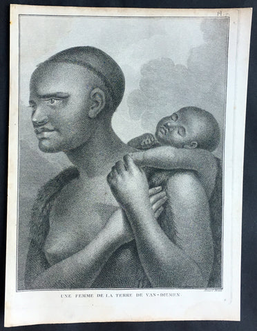
1785 Capt. Cook Antique Print Aboriginal Woman of Bruny Island, Tasmania in 1777
- Title : Une Femme De La Terre De Van-Diemens
- Ref : 50609
- Size: 10in x 8in (255mm x 205mm)
- Date : 1785
- Condition: (A+) Fine Condition
Description:
This fine original copper-plate engraved antique print of an Indigenous Woman & child of Adventure Bay, Bruny Island, Tasmania (Van Diemens Land) encountered by Captain Cook in during his 3rd & last Voyage of Discovery in 1777, was engraved by Robert Benard - after John Webber - and published in the 1785 French edition of Capt. James Cook & Capt. James King A Voyage to the Pacific Ocean. Undertaken, by the Command of his Majesty, for making Discoveries in the Northern Hemisphere. To determine The Position and Extent of the West Side of North America; its Distance from Asia; and the Practicability of a Northen Passage to Europe. Performed under the direction of Captains Cook, Clerke, and Gore, In His Majesty\'s Ships the Resolution and Discovery. In the Years 1776, 1777, 1778, 1779, and 1780. In Three Volumes. Vol. I and II written by James Cook, F.R.S. Vol. III by Captain James King, LL.D. and F.R.S. Paris, 1785.
Adventure Bay
from Cooks Journal......on the 24th (March 1777) at 3 AM we made the Coast of Van Diemen land wrote Cook. Anderson remarked that though now the middle of summer here a spot or two of snow was seen on the highest hills… At ten we passd a point supposd to be the boundary of Stone Bay where Abel Tasman anchord, i.e. Storm Bay. According to David Samwell, surgeons first mate on the Resolution, both Ships anchored in Adventure Bay in Van Diemens Land, this Bay was so called by Captn Furneaux who had anchored here in the Adventure last Voyage.
The next day Cook and Clerke sent parties, one to cut wood and the other grass. Clerke wrote of his party from the Discovery The Guard I had sent with the Parties on shore which consisted of the following Marines, Hamlet Thompson, Geo: Moody, Ben: Harriot, Jos: Pool & Willm Broom, stole some Liquor & made themselves exceedingly drunk, for which they receivd a dozen lashes each in the Morning. The Privates were all from the Plymouth division of marines. Hamlet Thompson was from the 6th Company, George Moody from the 70th, John Herriott the 12th, James Poole the 33rd and William Broom the 36th. According to Thomas Edgar, Master, they made themselves so Beastly Drunk that they were put motionless in the Boat, and when brought on board were oblig\'d to be hoisted into the Ship.
William Bayly, astronomer on the Discovery, wrote In the morning I carried my Tent observatory & Instruments on Shore & set all up, but was not able to get any observations it being cloudy all day, in the evening Capt Cook Sent for me & told me he had Altered his mind relative to his stay, & ordered me to pack all up & carry the whole on board again, as he intend[ed] to sail for New Zealand in a day or two.
John Henry Martin, seaman on the Discovery, described the natives. They have few, or no wants, & seemed perfectly Happy, if one might judge from their behaviour, for they frequently woud burst out, into the most immoderate fits of Laughter & when one Laughed every one followed his example Emediately.
General Definitions:
Paper thickness and quality: - Heavy and stable
Paper color : - off white
Age of map color: -
Colors used: -
General color appearance: -
Paper size: - 10in x 8in (255mm x 205mm)
Plate size: - 9 1/2in x 7 1/4in (240mm x 185mm)
Margins: - Min 1/2in (12mm)
Imperfections:
Margins: - None
Plate area: - None
Verso: - None
Background:
Adventure Bay is the name of both a township and a geographical feature on the eastern side of Bruny Island, Tasmania.
The first European to sight the bay was explorer Abel Tasman, who sought to anchor his vessel Heemskerck there in 1642. Instead, Heemskerck was driven back offshore by a storm, in token of which Tasman named the place Storm Bay. Captain Tobias Furneaux renamed it in March 1773, in honour of his ship HMS Adventure, which he had anchored in the bay for five days after becoming separated from Captain James Cook\'s HMS Resolution during Cook\'s second voyage to the Pacific search of Terra Australis Incognita. Furneaux\'s log made clear the bay was an excellent anchorage for resupplying vessels:....to the SW of the first watering place there is a large lagoon which I believe has plenty of fish in it for one of our Gentlemen caught upwards of 2 dozen trout, and shot a possum which was the only animal we saw. There are a great many gum trees and of a vast thickness and height, one of which measured in circumference 26 feet and the height under the branches was 20 feet.
Others among Furneaux\'s crew spotted evidence of what they believed were small deer but were more likely kangaroos. Furneaux also noted signs of an Aboriginal settlement in the form of several huts or wigwams on shore, with several bags of grass in which they carry their shellfish. - but the branches of which the huts were made were split and torn and there was not the least appearance of any people.
Reliably mapped and offering an abundance of water, fresh water and game, Adventure Bay quickly became a popular anchorage for European explorers. Cooks Resolution watered there in 1777, followed by William Bligh aboard HMS Bounty in 1788 and HMS Providence in 1792. Others who resupplied their vessels in the bay in this period included Bruni d Entrecasteaux aboard Recherché in 1792 and 1793, and Nicolas Baudin in the corvette Géographe in 1802. Matthew Flinders also tried to enter the bay with Norfolk in 1798.
John Hawkesworth 1715 – 1773 English writer and book editor.
He is said to have been clerk to an attorney, and was certainly self-educated. In 1744, he succeeded Samuel Johnson as compiler of the parliamentary debates for the Gentleman\\\'s Magazine, and from 1746 to 1749 he contributed poems signed Greville, or H Greville, to that journal. In company with Johnson and others he started a periodical called The Adventurer, which ran to 140 issues, of which 70 were from the pen of Hawkesworth himself.
On account of what was regarded as his powerful defense of morality and religion, Hawkesworth was rewarded by the archbishop of Canterbury with the degree of LL.D, In 1754–1755 he published an edition (12 vols) of Swifts works, with a life prefixed which Johnson praised in his Lives of the Poets. A larger edition (27 vols) appeared in 1766–1779. He adapted Dryden\\\'s Amphitryon for the Drury Lane stage in 1756, and Southernes Oronooko in 1759. He wrote the libretto of an oratorio Zimri in 1760, and the next year Edgar and Emmeline: a Fairy Tale was produced at Drury Lane. His Almoran and Hamet (1761) was first drafted as a play[citation needed], and a tragedy based on it by S J Pratt, The Fair Circassian (1781), met with some success.
He was commissioned by the Admiralty to edit Captain James Cooks papers relative to his first voyage. For this work, An Account of the Voyages undertaken ... for making discoveries in the Southern Hemisphere and performed by Commodore Byrone John Byron, Captain Wallis, Captain Carteret and Captain Cook (from 1702 to 1771) drawn up from the Journals ... (3 vols, 1773) Hawkesworth is said to have received from the publishers the sum of £6000. His descriptions of the manners and customs of the South Seas were, however, regarded by many critics as inexact and hurtful to the interests of morality, and the severity of their strictures is said to have hastened his death. He was buried in the parish church at Bromley, Kent, where he and his wife had kept a school.
Hawkesworth was a close imitator of Johnson both in style and thought, and was at one time on very friendly terms with him. It is said that he presumed on his success, and lost Johnsons friendship as early as 1756.
Captain James King FRS 1750 – 1784 was an officer of the Royal Navy. He served under James Cook on his last voyage around the world, specialising in taking important astronomical readings using a sextant. After Cook died he helped lead the ships on the remainder of their course, also completing Cook\\\'s account of the voyage. He continued his career in the Navy, reaching the rank of post-captain, commanding several ships and serving in the American War of Independence.
King joined HMS Resolution as second lieutenant, sharing the duties of astronomer with Cook, taking astronomical observations on board by sextant and with Larcum Kendals timekeeper K1, to establish the Resolutions position at sea and on shore by sextant or by astronomical quadrant to establish the geographical position of salient points during the course of Cooks surveys. Thus King\\\'s geographical positions were an important contribution to the accuracy of the various surveys carried out during the voyage and his use of the early chronometers helped prove their use at sea for calculation of Longitude. .
Following the death of Cook, King remained in the Resolution but on the death of Charles Clerke, Cooks successor, King was appointed to command HMS Discovery, the Resolution\\\'s consort, remaining in her for the rest of the voyage. After his return to England King was very much involved in the publication of the official account of Cooks third voyage, writing the third volume at Woodstock, near Oxford, where his brother Thomas was rector of St Mary Magdalene. But shortly after his return King was promoted Post-captain and appointed commander of HMS Crocodile in the English Channel.
John Webber RA 1751 – 1793 was an English artist who accompanied Captain Cook on his third Pacific expedition. He is best known for his images of Australasia, Hawaii and Alaska.
Webber was born in London, educated in Bern and studied painting at Paris.His father was Abraham Wäber, a Swiss sculptor who had moved to London, and changed his name to Webber before marrying a Mrs Mary Quant in 1744.
Webber served as official artist on James Cook\'s third voyage of discovery around the Pacific (1776–80) aboard HMS Resolution. At Adventure Bay in January 1777 he did drawings of A Man of Van Diemens Land and A Woman of Van Diemens Land. He also did many drawings of scenes in New Zealand and the South Sea islands. On this voyage, during which Cook lost his life in a fight in Hawaii, Webber became the first European artist to make contact with Hawaii, then called the Sandwich Islands. He made numerous watercolor landscapes of the islands of Kauai and Hawaii, and also portrayed many of the Hawaiian people.
In April 1778, Captain Cooks ships Resolution and Discovery anchored at Ship Cove, now known as Nootka Sound, Vancouver Island, Canada to refit. The crew took observations and recorded encounters with the local people. Webber made watercolour landscapes including Resolution and Discovery in Ship Cove, 1778. His drawings and paintings were engraved for British Admiraltys account of the expedition, which was published in 1784.
Back in England in 1780 Webber exhibited around 50 works at Royal Academy exhibitions between 1784 and 1792, and was elected an associate of the Royal Academy in 1785 and R.A. in 1791. Most of his work were landscapes. Sometimes figures were included as in A Party from H.M.S. Resolution shooting sea horses\", which was shown at the academy in 1784, and his The Death of Captain Cook became well known through an engraving of it. Another version of this picture is in the William Dixson gallery at Sydney
Robert Bénard 1734 – 1777 was an 18th-century French engraver.
Specialized in the technique of engraving, Robert Ménard is mainly famous for having supplied a significant amount of plates (at least 1,800) to the Encyclopédie by Diderot & d\'Alembert from 1751.
Later, publisher Charles-Joseph Panckoucke reused many of his productions to illustrate the works of his catalog.
1785 Capt. Cook Antique Print of a Man of Kamchatka Peninsula East Russia, 1779
- Title : Homme Du Kamtchatka
- Ref : 31798
- Size: 10in x 8in (255mm x 205mm)
- Date : 1785
- Condition: (A+) Fine Condition
Description:
This fine original copper-plate engraved antique print of a man of the Kamchatka Peninsula in Eastern Russia, drawn during a visit by Captain Clerke in 1779 (after Cooks death) during Captain Cooks 3rd and last Voyage of Discovery, was engraved by Robert Benard - after Cooks on-board artist, John Webber - and was published in the 1785 French edition of Capt. James Cook & Capt. James King A Voyage to the Pacific Ocean. Undertaken, by the Command of his Majesty, for making Discoveries in the Northern Hemisphere. To determine The Position and Extent of the West Side of North America; its Distance from Asia; and the Practicability of a Northen Passage to Europe. Performed under the direction of Captains Cook, Clerke, and Gore, In His Majesty\'s Ships the Resolution and Discovery. In the Years 1776, 1777, 1778, 1779, and 1780. In Three Volumes. Vol. I and II written by James Cook, F.R.S. Vol. III by Captain James King, LL.D. and F.R.S. Paris, 1785.
General Definitions:
Paper thickness and quality: - Heavy and stable
Paper color : - off white
Age of map color: -
Colors used: -
General color appearance: -
Paper size: - 10in x 8in (255mm x 205mm)
Plate size: - 9 1/2in x 7 1/4in (240mm x 185mm)
Margins: - Min 1/2in (12mm)
Imperfections:
Margins: - Light soiling in margins
Plate area: - None
Verso: - None
Background:
The Kamchatka Peninsula is a 1,250-kilometre-long peninsula in the Russian Far East.
After the death of James Cook in early 1779, Captain Charles Clerke took control of Cooks 3rd Voyage of Discovery. Clerke, who was dying of tuberculosis, sailed north of Hawaii, landing on the Kamchatka peninsula where the Russians helped him with supplies and to make repairs to the ships. He made a final attempt to pass beyond the Bering Strait and died on his return at Petropavlovsk on 22 August 1779. From here the ships\' reports were sent overland, reaching London five months later. Following the death of Clerke, Resolution and Discovery turned for home commanded by John Gore, a veteran of Cook\'s first voyage (and now in command of the expedition), and James King. After passing down the coast of Japan they reached Macao, in China in the first week of December and from there followed the East India trade route via Sunda Strait to Cape Town
Captain James King FRS 1750 – 1784 was an officer of the Royal Navy. He served under James Cook on his last voyage around the world, specialising in taking important astronomical readings using a sextant. After Cook died he helped lead the ships on the remainder of their course, also completing Cook\\\'s account of the voyage. He continued his career in the Navy, reaching the rank of post-captain, commanding several ships and serving in the American War of Independence.
King joined HMS Resolution as second lieutenant, sharing the duties of astronomer with Cook, taking astronomical observations on board by sextant and with Larcum Kendals timekeeper K1, to establish the Resolutions position at sea and on shore by sextant or by astronomical quadrant to establish the geographical position of salient points during the course of Cooks surveys. Thus King\\\'s geographical positions were an important contribution to the accuracy of the various surveys carried out during the voyage and his use of the early chronometers helped prove their use at sea for calculation of Longitude. .
Following the death of Cook, King remained in the Resolution but on the death of Charles Clerke, Cooks successor, King was appointed to command HMS Discovery, the Resolution\\\'s consort, remaining in her for the rest of the voyage. After his return to England King was very much involved in the publication of the official account of Cooks third voyage, writing the third volume at Woodstock, near Oxford, where his brother Thomas was rector of St Mary Magdalene. But shortly after his return King was promoted Post-captain and appointed commander of HMS Crocodile in the English Channel.
John Webber RA 1751 – 1793 was an English artist who accompanied Captain Cook on his third Pacific expedition. He is best known for his images of Australasia, Hawaii and Alaska.
Webber was born in London, educated in Bern and studied painting at Paris.His father was Abraham Wäber, a Swiss sculptor who had moved to London, and changed his name to Webber before marrying a Mrs Mary Quant in 1744.
Webber served as official artist on James Cook\'s third voyage of discovery around the Pacific (1776–80) aboard HMS Resolution. At Adventure Bay in January 1777 he did drawings of A Man of Van Diemens Land and A Woman of Van Diemens Land. He also did many drawings of scenes in New Zealand and the South Sea islands. On this voyage, during which Cook lost his life in a fight in Hawaii, Webber became the first European artist to make contact with Hawaii, then called the Sandwich Islands. He made numerous watercolor landscapes of the islands of Kauai and Hawaii, and also portrayed many of the Hawaiian people.
In April 1778, Captain Cooks ships Resolution and Discovery anchored at Ship Cove, now known as Nootka Sound, Vancouver Island, Canada to refit. The crew took observations and recorded encounters with the local people. Webber made watercolour landscapes including Resolution and Discovery in Ship Cove, 1778. His drawings and paintings were engraved for British Admiraltys account of the expedition, which was published in 1784.
Back in England in 1780 Webber exhibited around 50 works at Royal Academy exhibitions between 1784 and 1792, and was elected an associate of the Royal Academy in 1785 and R.A. in 1791. Most of his work were landscapes. Sometimes figures were included as in A Party from H.M.S. Resolution shooting sea horses\", which was shown at the academy in 1784, and his The Death of Captain Cook became well known through an engraving of it. Another version of this picture is in the William Dixson gallery at Sydney
Robert Bénard 1734 – 1777 was an 18th-century French engraver.
Specialized in the technique of engraving, Robert Ménard is mainly famous for having supplied a significant amount of plates (at least 1,800) to the Encyclopédie by Diderot & d\'Alembert from 1751.
Later, publisher Charles-Joseph Panckoucke reused many of his productions to illustrate the works of his catalog.
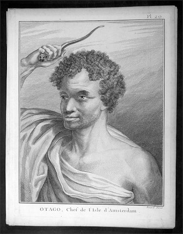
1785 Capt. Cook Antique Print of Chief Otago of Tongatapu, Tonga Islands in 1777
- Title : Otago, Chef de L Isle d Amersterdam
- Ref : 16358
- Size: 10in x 8in (255mm x 205mm)
- Date : 1785
- Condition: (A+) Fine Condition
Description:
This fine original copper-plate engraved antique print of Otago, Chief of the Island of Tongatapu (Amsterdam) the largest island in the Tonga Island, drawn during a visit by Captain Cook in 1777, during his 3rd and last Voyage of Discovery, was engraved by Robert Benard - after Cooks on-board artist, John Webber - and was published in the 1785 French edition of Capt. James Cook & Capt. James King A Voyage to the Pacific Ocean. Undertaken, by the Command of his Majesty, for making Discoveries in the Northern Hemisphere. To determine The Position and Extent of the West Side of North America; its Distance from Asia; and the Practicability of a Northen Passage to Europe. Performed under the direction of Captains Cook, Clerke, and Gore, In His Majesty\'s Ships the Resolution and Discovery. In the Years 1776, 1777, 1778, 1779, and 1780. In Three Volumes. Vol. I and II written by James Cook, F.R.S. Vol. III by Captain James King, LL.D. and F.R.S. Paris, 1785.
General Definitions:
Paper thickness and quality: - Heavy and stable
Paper color : - off white
Age of map color: -
Colors used: -
General color appearance: -
Paper size: - 10in x 8in (255mm x 205mm)
Plate size: - 9 1/2in x 7 1/4in (240mm x 185mm)
Margins: - Min 1/2in (12mm)
Imperfections:
Margins: - Light soiling in margins
Plate area: - None
Verso: - None
Background:
Tonga officially the Kingdom of Tonga, is a Polynesian sovereign state and archipelago comprising 169 islands, of which 36 are inhabited. The total surface area is about 750 square kilometres (290 sq mi) scattered over 700,000 square kilometres (270,000 sq mi) of the southern Pacific Ocean. It has a population of 107,122 people, of whom 70% reside on the main island of Tongatapu.
The Tongan people first encountered Europeans in 1616 when the Dutch vessel Eendracht, captained by Willem Schouten, made a short visit to trade. Later came other Dutch explorers, including Jacob Le Maire (who called on the northern island of Niuatoputapu); and in 1643 Abel Tasman (who visited Tongatapu and Haapai).
Later noteworthy European visitors included James Cook (Royal Navy) in 1773, 1774, and 1777; Alessandro Malaspina (Spanish Navy) in 1793; the first London missionaries in 1797; and the Wesleyan Methodist Reverend Walter Lawry in 1822.
Tonga became known in the West as the Friendly Islands because of the congenial reception accorded to Captain James Cook on his first visit in 1773. He arrived at the time of the inasi festival, the yearly donation of the First Fruits to the Tui Tonga (the islands paramount chief) and so received an invitation to the festivities. According to the writer William Mariner, the chiefs wanted to kill Cook during the gathering but could not agree on a plan.
Captain James King FRS 1750 – 1784 was an officer of the Royal Navy. He served under James Cook on his last voyage around the world, specialising in taking important astronomical readings using a sextant. After Cook died he helped lead the ships on the remainder of their course, also completing Cook\\\'s account of the voyage. He continued his career in the Navy, reaching the rank of post-captain, commanding several ships and serving in the American War of Independence.
King joined HMS Resolution as second lieutenant, sharing the duties of astronomer with Cook, taking astronomical observations on board by sextant and with Larcum Kendals timekeeper K1, to establish the Resolutions position at sea and on shore by sextant or by astronomical quadrant to establish the geographical position of salient points during the course of Cooks surveys. Thus King\\\'s geographical positions were an important contribution to the accuracy of the various surveys carried out during the voyage and his use of the early chronometers helped prove their use at sea for calculation of Longitude. .
Following the death of Cook, King remained in the Resolution but on the death of Charles Clerke, Cooks successor, King was appointed to command HMS Discovery, the Resolution\\\'s consort, remaining in her for the rest of the voyage. After his return to England King was very much involved in the publication of the official account of Cooks third voyage, writing the third volume at Woodstock, near Oxford, where his brother Thomas was rector of St Mary Magdalene. But shortly after his return King was promoted Post-captain and appointed commander of HMS Crocodile in the English Channel.
John Webber RA 1751 – 1793 was an English artist who accompanied Captain Cook on his third Pacific expedition. He is best known for his images of Australasia, Hawaii and Alaska.
Webber was born in London, educated in Bern and studied painting at Paris.His father was Abraham Wäber, a Swiss sculptor who had moved to London, and changed his name to Webber before marrying a Mrs Mary Quant in 1744.
Webber served as official artist on James Cook\'s third voyage of discovery around the Pacific (1776–80) aboard HMS Resolution. At Adventure Bay in January 1777 he did drawings of A Man of Van Diemens Land and A Woman of Van Diemens Land. He also did many drawings of scenes in New Zealand and the South Sea islands. On this voyage, during which Cook lost his life in a fight in Hawaii, Webber became the first European artist to make contact with Hawaii, then called the Sandwich Islands. He made numerous watercolor landscapes of the islands of Kauai and Hawaii, and also portrayed many of the Hawaiian people.
In April 1778, Captain Cooks ships Resolution and Discovery anchored at Ship Cove, now known as Nootka Sound, Vancouver Island, Canada to refit. The crew took observations and recorded encounters with the local people. Webber made watercolour landscapes including Resolution and Discovery in Ship Cove, 1778. His drawings and paintings were engraved for British Admiraltys account of the expedition, which was published in 1784.
Back in England in 1780 Webber exhibited around 50 works at Royal Academy exhibitions between 1784 and 1792, and was elected an associate of the Royal Academy in 1785 and R.A. in 1791. Most of his work were landscapes. Sometimes figures were included as in A Party from H.M.S. Resolution shooting sea horses\", which was shown at the academy in 1784, and his The Death of Captain Cook became well known through an engraving of it. Another version of this picture is in the William Dixson gallery at Sydney
Robert Bénard 1734 – 1777 was an 18th-century French engraver.
Specialized in the technique of engraving, Robert Ménard is mainly famous for having supplied a significant amount of plates (at least 1,800) to the Encyclopédie by Diderot & d\'Alembert from 1751.
Later, publisher Charles-Joseph Panckoucke reused many of his productions to illustrate the works of his catalog.
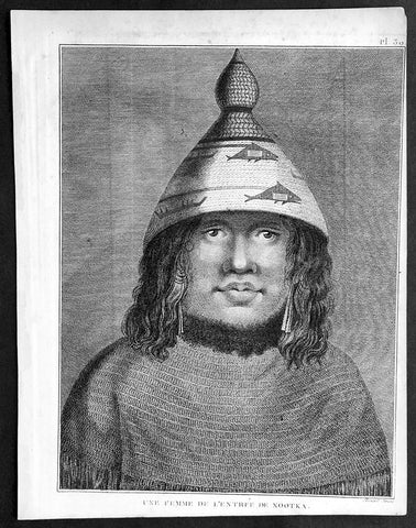
1785 Capt. Cook Antique Print Woman of Nootka Sound, Vancouver Isle Canada, 1778
- Title : Une Femme De L Entreee De Nootka
- Ref : 31768
- Size: 10in x 8in (255mm x 205mm)
- Date : 1785
- Condition: (A+) Fine Condition
Description:
This fine original copper-plate engraved antique print of a woman of Nootka Sound, on the West Coast of Vancouver Island, Canada, drawn during a visit by Captain Cook in 1778, during his 3rd and last Voyage of Discovery, was engraved by Robert Benard - after Cooks on-board artist, John Webber - and was published in the 1785 French edition of Capt. James Cook & Capt. James King A Voyage to the Pacific Ocean. Undertaken, by the Command of his Majesty, for making Discoveries in the Northern Hemisphere. To determine The Position and Extent of the West Side of North America; its Distance from Asia; and the Practicability of a Northen Passage to Europe. Performed under the direction of Captains Cook, Clerke, and Gore, In His Majesty\'s Ships the Resolution and Discovery. In the Years 1776, 1777, 1778, 1779, and 1780. In Three Volumes. Vol. I and II written by James Cook, F.R.S. Vol. III by Captain James King, LL.D. and F.R.S. Paris, 1785.
General Definitions:
Paper thickness and quality: - Heavy and stable
Paper color : - off white
Age of map color: -
Colors used: -
General color appearance: -
Paper size: - 10in x 8in (255mm x 205mm)
Plate size: - 9 1/2in x 7 1/4in (240mm x 185mm)
Margins: - Min 1/2in (12mm)
Imperfections:
Margins: - Light soiling in margins
Plate area: - None
Verso: - None
Background:
Nootka Sound is a sound of the Pacific Ocean, on the rugged west coast of Vancouver Island, in the Canadian province of British Columbia, historically known as King George\'s Sound. It separates Vancouver Island and Nootka Island.
On August 8, 1774, the Spanish Navy ship Santiago, under Juan Pérez, entered and anchored in the inlet. Although the Spanish did not land, natives paddled to the ship to trade furs for abalone shells from California. Pérez named the entrance to Nootka Sound Surgidero de San Lorenzo. The word surgidero means source. When Esteban José Martinez arrived in 1789 he gave Nootka Sound the name Puerto de San Lorenzo de Nuca. The Spanish establishment established at Friendly Cove he gave the name Santa Cruz de Nuca.
In March 1778, Captain James Cook of the Royal Navy landed on Bligh Island and named the inlet\"King George\'s Sound. He recorded that the native name was Nutka or Nootka, apparently misunderstanding his conversations at Friendly Cove/Yuquot; his informant may have been explaining that he was on an island (itchme nutka, a place you can go around). There may also have been confusion with Nuu-chah-nulth, the natives\' autonym (name for themselves). It may also have simply been based on Cook’s mis-pronunciation of Yuquot, the native name of the place. The earlier Spanish and British names for the Sound swiftly went out of use.
At the time, the Spanish monopolized the trade between Asia and North America, and had granted limited licenses to the Portuguese. The Russians had established a growing fur trading system in Alaska. The Spanish began to challenge the Russians, with Pérez\'s voyage being the first of many to the Pacific Northwest. The British also became increasingly active in the region.
The next European to visit Nootka Sound after James Cook was the British trader James Hanna in August 1785. Hanna traded iron bars for furs. He sold the furs in China for a handsome profit, beginning an era of the Maritime Fur Trade.
Captain James King FRS 1750 – 1784 was an officer of the Royal Navy. He served under James Cook on his last voyage around the world, specialising in taking important astronomical readings using a sextant. After Cook died he helped lead the ships on the remainder of their course, also completing Cook\\\'s account of the voyage. He continued his career in the Navy, reaching the rank of post-captain, commanding several ships and serving in the American War of Independence.
King joined HMS Resolution as second lieutenant, sharing the duties of astronomer with Cook, taking astronomical observations on board by sextant and with Larcum Kendals timekeeper K1, to establish the Resolutions position at sea and on shore by sextant or by astronomical quadrant to establish the geographical position of salient points during the course of Cooks surveys. Thus King\\\'s geographical positions were an important contribution to the accuracy of the various surveys carried out during the voyage and his use of the early chronometers helped prove their use at sea for calculation of Longitude. .
Following the death of Cook, King remained in the Resolution but on the death of Charles Clerke, Cooks successor, King was appointed to command HMS Discovery, the Resolution\\\'s consort, remaining in her for the rest of the voyage. After his return to England King was very much involved in the publication of the official account of Cooks third voyage, writing the third volume at Woodstock, near Oxford, where his brother Thomas was rector of St Mary Magdalene. But shortly after his return King was promoted Post-captain and appointed commander of HMS Crocodile in the English Channel.
John Webber RA 1751 – 1793 was an English artist who accompanied Captain Cook on his third Pacific expedition. He is best known for his images of Australasia, Hawaii and Alaska.
Webber was born in London, educated in Bern and studied painting at Paris.His father was Abraham Wäber, a Swiss sculptor who had moved to London, and changed his name to Webber before marrying a Mrs Mary Quant in 1744.
Webber served as official artist on James Cook\'s third voyage of discovery around the Pacific (1776–80) aboard HMS Resolution. At Adventure Bay in January 1777 he did drawings of A Man of Van Diemens Land and A Woman of Van Diemens Land. He also did many drawings of scenes in New Zealand and the South Sea islands. On this voyage, during which Cook lost his life in a fight in Hawaii, Webber became the first European artist to make contact with Hawaii, then called the Sandwich Islands. He made numerous watercolor landscapes of the islands of Kauai and Hawaii, and also portrayed many of the Hawaiian people.
In April 1778, Captain Cooks ships Resolution and Discovery anchored at Ship Cove, now known as Nootka Sound, Vancouver Island, Canada to refit. The crew took observations and recorded encounters with the local people. Webber made watercolour landscapes including Resolution and Discovery in Ship Cove, 1778. His drawings and paintings were engraved for British Admiraltys account of the expedition, which was published in 1784.
Back in England in 1780 Webber exhibited around 50 works at Royal Academy exhibitions between 1784 and 1792, and was elected an associate of the Royal Academy in 1785 and R.A. in 1791. Most of his work were landscapes. Sometimes figures were included as in A Party from H.M.S. Resolution shooting sea horses\", which was shown at the academy in 1784, and his The Death of Captain Cook became well known through an engraving of it. Another version of this picture is in the William Dixson gallery at Sydney
Robert Bénard 1734 – 1777 was an 18th-century French engraver.
Specialized in the technique of engraving, Robert Ménard is mainly famous for having supplied a significant amount of plates (at least 1,800) to the Encyclopédie by Diderot & d\'Alembert from 1751.
Later, publisher Charles-Joseph Panckoucke reused many of his productions to illustrate the works of his catalog.
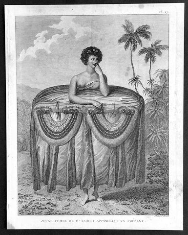
1785 Capt. Cook Visit to Tahiti in 1777 - Antique Print of Gifts for Cook & Men
- Title : Jeune Femme De O-Tahiti Apportant un Present
- Ref : 21348
- Size: 10in x 8in (255mm x 205mm)
- Date : 1785
- Condition: (A+) Fine Condition
Description:
This fine original copper-plate engraved antique print of a young Tahitian woman giving the ritual presentation of gifts of tapa cloth and two breast plates, along with food to Captain Cook and his crew, during a visit by Cook in 1777 during his 3rd and last Voyage of Discovery, was engraved by Robert Benard - after Cooks on-board artist, John Webber - and was published in the 1785 French edition of Capt. James Cook & Capt. James King A Voyage to the Pacific Ocean. Undertaken, by the Command of his Majesty, for making Discoveries in the Northern Hemisphere. To determine The Position and Extent of the West Side of North America; its Distance from Asia; and the Practicability of a Northen Passage to Europe. Performed under the direction of Captains Cook, Clerke, and Gore, In His Majesty\'s Ships the Resolution and Discovery. In the Years 1776, 1777, 1778, 1779, and 1780. In Three Volumes. Vol. I and II written by James Cook, F.R.S. Vol. III by Captain James King, LL.D. and F.R.S. Paris, 1785.
............Webber remarked on the ritual presentation of gifts of tapa cloth and two breast plates, along with food to Cook and his crew by two girls. The design of the girl’s attire recalls the wide panniers of eighteenth-century fashion, suggesting that the artist may have taken significant artistic license. However, the depiction is in concordance with Cook’s account. He describes seeing the girls dressed prior to their presentation, remarking on the “rather curious” manner in which one end of the cloth “was held up over the girls heads while the remainder was wraped round them under the armpits, then the upper ends were let fall and hung down in foulds to the ground over the other and looked something like a circular hooped petticoat. After ward round the out side of all were, were wraped several pieces of different Coloured cloth, which considerably increased the Size so that the whole was not less than five or six yards in circuit and was as much as the girls could support..............
General Definitions:
Paper thickness and quality: - Heavy and stable
Paper color : - off white
Age of map color: -
Colors used: -
General color appearance: -
Paper size: - 10in x 8in (255mm x 205mm)
Plate size: - 9 1/2in x 7 1/4in (240mm x 185mm)
Margins: - Min 1/2in (12mm)
Imperfections:
Margins: - Light soiling in margins
Plate area: - None
Verso: - None
Background:
Tahiti previously also known as Otaheite is the largest island in the Windward group of French Polynesia. The island is located in the archipelago of the Society Islands in the central Southern Pacific Ocean.
The first European to have visited Tahiti according to existing records was lieutenant Samuel Wallis, who was circumnavigating the globe in HMS Dolphin, sighting the island on 18 June 1767, and eventually harboring in Matavai Bay. This bay was situated on the territory of the chiefdom of Pare-Arue, governed by Tu (Tu-nui-e-a\\\\\\\'a-i-te-Atua) and his regent Tutaha, and the chiefdom of Ha apape, governed by Amo and his wife Oberea (Purea). Wallis named the island King Georges Island. The first contacts were difficult, since on the 24 and 26 June 1767, Tahitian warriors in canoes showed aggression towards the British, hurling stones from their slings. In retaliation, the British sailors opened fire on the warriors in the canoes and on the hills. In reaction to this powerful counter-attack, the Tahitians laid down peace offerings for the British. Following this episode, Samuel Wallis was able to establish cordial relations with the female chieftain “Oberea “ (Purea) and remained on the island until 27 July 1767.
In July 1768, Captain James Cook was commissioned by the Royal Society and on orders from the Lords Commissioners of the Admiralty to observe the transit of Venus across the sun, a phenomenon that would be visible from Tahiti on 3 June 1769. He arrived in Tahitis Matavai Bay, commanding the HMS Endeavour on 12 April 1769. On 14 April, Cook met with Tutaha and Tepau. On 15 April, Cook picked the site for a fortified camp at Point Venus along with Banks, Parkinson, Daniel Solander, to protect Charles Greens observatory. The length of stay enabled them to undertake for the first time real ethnographic and scientific observations of the island. Assisted by the botanist Joseph Banks, and by the artist Sydney Parkinson, Cook gathered valuable information on the fauna and flora, as well as the native society, language and customs, including the proper name of the island, Otaheite. On 28 April, Cook met Purea and Tupaia, and Tupaia befriended Banks following the transit. On 21 June, Amo visited Cook, and then on 25 June, Pohuetea visited, signifying another chief seeking to ally himself with the British.
Cook and Banks circumnavigated the island from 26 June to 1 July. On the exploration, they met Ahio, chief of Ha apaiano o or Papenoo, Rita, chief of Hitia a, Pahairro, chief of Pueu, Vehiatua, chief of Tautra, Matahiapo, chief of Teahupo o, Tutea, chief of Vaira o, and Moe, chief of Afa\\\\\\\'Ahiti. In Papara, guided by Tupaia, they investigated the ruins of Mahaiatea marae, an impressive structure containing a stone pyramid or ahu, measuring 44 feet high, 267 feet long and 87 feet wide. Cook and the Endeavour departed Tahiti on 13 July 1769, taking Raiatean navigator Tupaia along for his geographic knowledge of the islands.
Cook returned to Tahiti between 15 August and 1 September 1773, greeted by the chiefs Tai and Puhi, besides the youg ari i Vehiatua II and his stepfather Ti itorea. Cook anchored in Vaitepiha Bay before returning to Point Venus where he met Tu, the paramount chief. Cook picked up two passengers from Tahiti during this trip, Porea and Ma\\\\\\\'i, with Hitihiti later replacing Porea when Cook stopped at Raiatea. Cook took Hitihiti to Tahiti on 22 April, during his return leg. Then, Cook departed Tahiti on 14 May 1774.
During his final visit, Cook returned Mai to Tahiti on 12 Aug. 1777, after Mais long visit in England. Cook also brought two Maori from Queen Charlotte Sound, Te Weherua and Koa. Cook first harbored in Vaitepiha Bay, where he visited Vehiatua II s funeral bier and the prefabricated Spanish mission house. Cook also met Vehiatua III, and inscribed on the back of the Spanish cross, Georgius tertius Rex Annis 1767, 69, 73, 74 & 77, as a counterpoint to Christus Vincit Carolus III imperat 1774 on the front. On 23 Aug., Cook sailed for Matavai Bay, where he met Tu, his father Teu, his mother Tetupaia, his brothers Ari ipaea and Vaetua, and his sisters Ari ipaea-vahine, Tetua-te-ahamai, and Auo. Cook also observed a human sacrifice, taata tapu, at the Utu-ai-mahurau marae, and 49 skulls from previous victims.
On 29 Sept. 1777, Cook sailed for Papetoai Bay on Moorea. Cook met Mahine in an act of friendship on 3 Oct., though he was an enemy of Tu. When a goat kid was stolen on 6 Oct., Cook in a rampage, ordered the burning of houses and canoes until it was returned. Cook sailed for Huahine on 11 Oct., Raiatea on 2 Nov., and Borabora on 7 Dec.
On 26 October 1788, HMS Bounty, under the command of Captain William Bligh, landed in Tahiti with the mission of carrying Tahitian breadfruit trees (Tahitian: uru) to the Caribbean. Sir Joseph Banks, the botanist from James Cooks first expedition, had concluded that this plant would be ideal to feed the African slaves working in the Caribbean plantations at very little cost. The crew remained in Tahiti for about five months, the time needed to transplant the seedlings of the trees. Three weeks after leaving Tahiti, on 28 April 1789, the crew mutinied on the initiative of Fletcher Christian. The mutineers seized the ship and set the captain and most of those members of the crew who remained loyal to him adrift in a ship\\\\\\\'s boat. A group of mutineers then went back to settle in Tahiti.
Although various explorers had refused to get involved in tribal conflicts, the mutineers from the Bounty offered their services as mercenaries and furnished arms to the family which became the Pōmare Dynasty. The chief Tū knew how to use their presence in the harbours favoured by sailors to his advantage. As a result of his alliance with the mutineers, he succeeded in considerably increasing his supremacy over the island of Tahiti.
Captain James King FRS 1750 – 1784 was an officer of the Royal Navy. He served under James Cook on his last voyage around the world, specialising in taking important astronomical readings using a sextant. After Cook died he helped lead the ships on the remainder of their course, also completing Cook\\\'s account of the voyage. He continued his career in the Navy, reaching the rank of post-captain, commanding several ships and serving in the American War of Independence.
King joined HMS Resolution as second lieutenant, sharing the duties of astronomer with Cook, taking astronomical observations on board by sextant and with Larcum Kendals timekeeper K1, to establish the Resolutions position at sea and on shore by sextant or by astronomical quadrant to establish the geographical position of salient points during the course of Cooks surveys. Thus King\\\'s geographical positions were an important contribution to the accuracy of the various surveys carried out during the voyage and his use of the early chronometers helped prove their use at sea for calculation of Longitude. .
Following the death of Cook, King remained in the Resolution but on the death of Charles Clerke, Cooks successor, King was appointed to command HMS Discovery, the Resolution\\\'s consort, remaining in her for the rest of the voyage. After his return to England King was very much involved in the publication of the official account of Cooks third voyage, writing the third volume at Woodstock, near Oxford, where his brother Thomas was rector of St Mary Magdalene. But shortly after his return King was promoted Post-captain and appointed commander of HMS Crocodile in the English Channel.
John Webber RA 1751 – 1793 was an English artist who accompanied Captain Cook on his third Pacific expedition. He is best known for his images of Australasia, Hawaii and Alaska.
Webber was born in London, educated in Bern and studied painting at Paris.His father was Abraham Wäber, a Swiss sculptor who had moved to London, and changed his name to Webber before marrying a Mrs Mary Quant in 1744.
Webber served as official artist on James Cook\'s third voyage of discovery around the Pacific (1776–80) aboard HMS Resolution. At Adventure Bay in January 1777 he did drawings of A Man of Van Diemens Land and A Woman of Van Diemens Land. He also did many drawings of scenes in New Zealand and the South Sea islands. On this voyage, during which Cook lost his life in a fight in Hawaii, Webber became the first European artist to make contact with Hawaii, then called the Sandwich Islands. He made numerous watercolor landscapes of the islands of Kauai and Hawaii, and also portrayed many of the Hawaiian people.
In April 1778, Captain Cooks ships Resolution and Discovery anchored at Ship Cove, now known as Nootka Sound, Vancouver Island, Canada to refit. The crew took observations and recorded encounters with the local people. Webber made watercolour landscapes including Resolution and Discovery in Ship Cove, 1778. His drawings and paintings were engraved for British Admiraltys account of the expedition, which was published in 1784.
Back in England in 1780 Webber exhibited around 50 works at Royal Academy exhibitions between 1784 and 1792, and was elected an associate of the Royal Academy in 1785 and R.A. in 1791. Most of his work were landscapes. Sometimes figures were included as in A Party from H.M.S. Resolution shooting sea horses\", which was shown at the academy in 1784, and his The Death of Captain Cook became well known through an engraving of it. Another version of this picture is in the William Dixson gallery at Sydney
Robert Bénard 1734 – 1777 was an 18th-century French engraver.
Specialized in the technique of engraving, Robert Ménard is mainly famous for having supplied a significant amount of plates (at least 1,800) to the Encyclopédie by Diderot & d\'Alembert from 1751.
Later, publisher Charles-Joseph Panckoucke reused many of his productions to illustrate the works of his catalog.
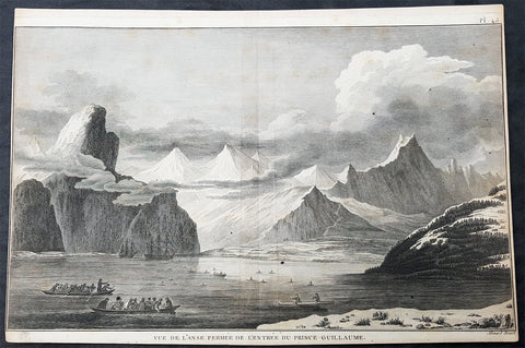
1785 Cook Antique Print HMS Resolution & Discovery, Prince William Sound, Alaska
- Title : Vue de Lanse Fermee de l entree Du Prince Guillaume (Entrance & view of the Prince William)
- Size: 14 1/2in x 10in (370mm x 255mm)
- Ref #: 31839
- Date : 1785
- Condition: (A) Very Good Condition
Description:
This fine original copper-plate engraved antique print of Captain Cooks ships HMS Resolution and Discovery anchored in Snug Corner Cove, Prince William Sound, Alaska, visited by Captain Cook in 1778, during his 3rd & last Voyage of Discovery, was engraved by Robert Benard - after John Webber - and was published in the 1785 French edition of Capt. James Cook & Capt. James King publication A Voyage to the Pacific Ocean. Undertaken, by the Command of his Majesty, for making Discoveries in the Northern Hemisphere. To determine The Position and Extent of the West Side of North America; its Distance from Asia; and the Practicability of a Northern Passage to Europe. Performed under the direction of Captains Cook, Clerke, and Gore, In His Majestys Ships the Resolution and Discovery. In the Years 1776, 1777, 1778, 1779, and 1780. In Three Volumes. Vol. I and II written by James Cook, F.R.S. Vol. III by Captain James King, LL.D. and F.R.S. Paris, 1785.
May 1778.........On the 12th at nine in the morning, wrote Ledyard, we entered an inlet… at six in the evening perceiving bad weather approaching… both ships anchored… The pinnace of the Resolution with the first lieutenant, some other gentlemen and myself went to the opposite shore to shoot some wild fowl. The first lieutenant was John Gore. The inlet was named Sandwich Sound by Cook, after the Earl of Sandwich, First Lord of the Admiralty, but in the published version of his journal the name appeared as Prince Williams Sound, after George IIIs third son, Duke of Clarence, later William IV. The ships had anchored off Cape Hinchinbrook, named after the country seat of the Earl of Sandwich.
Some local inhabitants appeared and came aboard the ships. Clerke gave them a Glass Bowl, with which they seem\'d much delighted, and toss\'d me, in spight of all my motions to the contrary, one of their Frocks, which was made of Water fowl Skins, and exceedingly well calculated, to keep out both Wet & Cold; then, both Boats put off and made for the Shore, paddling & singing with all the Jollity imaginable. We either found these good folks on of their Jubilee Days, or they are a very happy Race.
They sailed on until Cook found a fine bay or rather harbour which he later called a very snug place and named Snug Corner Bay. Samwell on 14th wrote we secured the Ship with the small Anchor; in carrying this out in the Launch one of the Sailors was so unfortunate as to get his Leg entangled in the Buoy rope which carried him down with the Anchor, however he disengaged himself when he got to the bottom & came up again & saved his Life tho\' he had his Leg broke in a very dangerous Manner.
We heeled the ship to port wrote Gilbert, to examine the leak on the starboard buttock… it being close below the wale and occasioned by some of the seems being very open and the oakum quite rotten and great part of it got out. In two days we repaired this defect being obliged to put two and half inch rope along the seams which were too wide for caulking.
On 18th King noted two boats, one with Mr Gore & the other with the Master, were sent away, the first to explore the Inlet to the Noward: the other to the N end of the Island near us to make observations on the tides. William Bligh was master on the Resolution. They returned by Dusk, Mr Gore had proceeded up the Inlet & perceivd that it took a direction to the NE, & he thought that it bid fair for opening a communication to some other Sea; but the mate that was with him form\'d a very contrary opinion… the Captn judg\'d it the Wisest way to lose no more time, being certain that if we were amongst Islands, we shoud soon come to more Passages. Henry Roberts was the masters mate referred to here. Cook had sent him and others to sketch out the parts they examined
General Definitions:
Paper thickness and quality: - Heavy and stable
Paper color : - off white
Age of map color: -
Colors used: -
General color appearance: -
Paper size: - 14 1/2in x 10in (370mm x 255mm)
Plate size: - 14in x 10in (365mm x 255mm)
Margins: - Min 1/2in (12mm)
Imperfections:
Margins: - L&R margins cropped close to borders
Plate area: - None
Verso: - Light soiling
Background:
Prince William Sound is located on the south coast of the U.S. state of Alaska. It is located on the east side of the Kenai Peninsula, its largest port is Valdez, at the southern terminus of the Trans-Alaska Pipeline System. Other settlements on the sound contain numerous small islands, including Cordova and Whittier plus the Alaska native villages of Chenega and Tatitlek.
James Cook entered Prince William Sound in 1778 and named it Sandwich Sound, after his patron the Earl of Sandwich. The name was changed to honour King George III third son, Prince William Henry, then aged 13 and serving as a midshipman in the Royal Navy.
Captain James King FRS 1750 – 1784 was an officer of the Royal Navy. He served under James Cook on his last voyage around the world, specialising in taking important astronomical readings using a sextant. After Cook died he helped lead the ships on the remainder of their course, also completing Cooks account of the voyage. He continued his career in the Navy, reaching the rank of post-captain, commanding several ships and serving in the American War of Independence.
King joined HMS Resolution as second lieutenant, sharing the duties of astronomer with Cook, taking astronomical observations on board by sextant and with Larcum Kendals timekeeper K1, to establish the Resolutions position at sea and on shore by sextant or by astronomical quadrant to establish the geographical position of salient points during the course of Cooks surveys. Thus Kings geographical positions were an important contribution to the accuracy of the various surveys carried out during the voyage and his use of the early chronometers helped prove their use at sea for calculation of Longitude. .
Following the death of Cook, King remained in the Resolution but on the death of Charles Clerke, Cooks successor, King was appointed to command HMS Discovery, the Resolutions consort, remaining in her for the rest of the voyage. After his return to England King was very much involved in the publication of the official account of Cooks third voyage, writing the third volume at Woodstock, near Oxford, where his brother Thomas was rector of St Mary Magdalene. But shortly after his return King was promoted Post-captain and appointed commander of HMS Crocodile in the English Channel.
John Webber RA 1751 – 1793 was an English artist who accompanied Captain Cook on his third Pacific expedition. He is best known for his images of Australasia, Hawaii and Alaska.
Webber was born in London, educated in Bern and studied painting at Paris.His father was Abraham Wäber, a Swiss sculptor who had moved to London, and changed his name to Webber before marrying a Mrs Mary Quant in 1744.
Webber served as official artist on James Cooks third voyage of discovery around the Pacific (1776–80) aboard HMS Resolution. At Adventure Bay in January 1777 he did drawings of A Man of Van Diemens Land and A Woman of Van Diemens Land. He also did many drawings of scenes in New Zealand and the South Sea islands. On this voyage, during which Cook lost his life in a fight in Hawaii, Webber became the first European artist to make contact with Hawaii, then called the Sandwich Islands. He made numerous watercolor landscapes of the islands of Kauai and Hawaii, and also portrayed many of the Hawaiian people.
In April 1778, Captain Cooks ships Resolution and Discovery anchored at Ship Cove, now known as Nootka Sound, Vancouver Island, Canada to refit. The crew took observations and recorded encounters with the local people. Webber made watercolour landscapes including Resolution and Discovery in Ship Cove, 1778. His drawings and paintings were engraved for British Admiraltys account of the expedition, which was published in 1784.
Back in England in 1780 Webber exhibited around 50 works at Royal Academy exhibitions between 1784 and 1792, and was elected an associate of the Royal Academy in 1785 and R.A. in 1791. Most of his work were landscapes. Sometimes figures were included as in A Party from H.M.S. Resolution shooting sea horses, which was shown at the academy in 1784, and his The Death of Captain Cook became well known through an engraving of it. Another version of this picture is in the William Dixson gallery at Sydney
Robert Bénard 1734 – 1777 was an 18th-century French engraver.
Specialized in the technique of engraving, Robert Ménard is mainly famous for having supplied a significant amount of plates (at least 1,800) to the Encyclopédie by Diderot & d Alembert from 1751.
Later, publisher Charles-Joseph Panckoucke reused many of his productions to illustrate the works of his catalog.
1785 De Vaugondy & Jefferson Antique Early Map of The United States of America
- Title : Etats-Unis de l'Amerique Septentrionale avec les Isles Royale, de Terre Neuve de St. Jean, l'Acadie &c. 1785 M. Robert de Vaugondy....Boudet....
- Date : 1785
- Condition: (A+) Fine Condition
- Ref: 93513
- Size: 26in x 20 1/2in (660mm x 520mm)
Description:
This large original hand coloured copper-plate engraved very important, early & scarce antique early map of the United States (Etats-Unis De L Amerique), during what is know as the Confederation Period, by Robert De Vaugondy was published by the French printer Antoine Boudet (1715 - 1787) for the supplement of de Vaugondys Atlas Universal
This scarce first state map is very important to the formation of the United States of America. The map is the first to describe what is know as the Jeffersonian Ordinance, showing the new international borders of the fledgling United States, the inclusion of the original 13 states in the bottom right text box (the first map to do so) along with the inclusion of Michigan, ratified under the Treaty of Paris in 1783.
The successor to De Vaugondy, Charles Francois Delamarche (1740 - 1817) was a known correspondent to Thomas Jefferson and along with the printer Boudet would have played an important part in the publication of this map. The Ordinance of 1784 was a plan to outline the new territories and states, that would eventually make up the foundation of the United States, ratified by the Treaty of Paris. Given that this map was engraved in 1785 or possibly earlier and that Delamarche was a friend of Jefferson, it is not a stretch to believe that he was one of the first, if not the first, to map the new country of the United States (Etats-Unis De L Amerique)
General Definitions:
Paper thickness and quality: - Heavy and stable
Paper color : - off white
Age of map color: - Original
Colors used: - Yellow, green, blue, pink
General color appearance: - Authentic
Paper size: - 26 1/2in x 20 1/2in (670mm x 520mm)
Plate size: - 25 1/2in x 19 1/2in (650mm x 500mm)
Margins: - Min 1/2in (12mm)
Imperfections:
Margins: - Light age toning in margins
Plate area: - Light creasing along centerfold
Verso: - None
Background:
The Confederation Period was the era of United States history in the 1780s after the American Revolution and prior to the ratification of the United States Constitution. In 1781, the United States ratified the Articles of Confederation and prevailed in the Battle of Yorktown, the last major land battle between British and American forces in the American Revolutionary War. American independence was confirmed with the 1783 signing of the Treaty of Paris. The fledgling United States faced several challenges, many of which stemmed from the lack of a strong national government and unified political culture. The period ended in 1789 following the ratification of the United States Constitution, which established a new, more powerful, national government.
The Articles of Confederation established a loose confederation of states with a weak federal government. An assembly of delegates acted on behalf of the states they represented. This unicameral body, officially referred to as the United States in Congress Assembled, had little authority, and could not accomplish anything independent of the states. It had no chief executive, and no court system. Congress lacked the power to levy taxes, regulate foreign or interstate commerce, or effectively negotiate with foreign powers. The weakness of Congress proved self-reinforcing, as the leading political figures of the day served in state governments or foreign posts. The failure of the national government to handle the challenges facing the United States led to calls for reform and frequent talk of secession.
The Treaty of Paris left the United States with a vast territory spanning from the Atlantic Ocean to the Mississippi River. Settlement of the trans-Appalachian territories proved difficult, in part due to the resistance of Native Americans and the neighboring foreign powers of Great Britain and Spain. The British refused to evacuate US territory, while the Spanish used their control of the Mississippi River to stymie Western settlement. In 1787, Congress passed the Northwest Ordinance, which set an important precedent by establishing the first organized territory under the control of the national government.
After Congressional efforts to amend the Articles failed, numerous national leaders met in Philadelphia in 1787 to establish a new constitution. The new constitution was ratified in 1788, and the new federal government began meeting in 1789, marking the end of the Confederation Period. Some historians believe that the 1780s were a bleak, terrible time for the US, while others have argued that the period was actually stable and relatively prosperous.
1785 Du Bocage & Barthelemy Antique Map of Phocis, Greece - Oracle of Delphi
- Title : La Phocide et La Doride...1787
- Size: 15in x 10in (380mm x 255mm)
- Ref #: 16457
- Date : 1787
- Condition: (A+) Fine Condition
Description:
This original copper-plate engraved map by Jean Denis Barbie du Bocage was engraved in 1787 - dated in the title - and was published in the 1787 edition of Jean-Jacques Barthelemy famous Voyage du jeune Anarcharsis en Grece or Travels of Anacharsis the younger in Greece in 4 volumes.
General Definitions:
Paper thickness and quality: - Heavy and stable
Paper color : - off white
Age of map color: -
Colors used: -
General color appearance: -
Paper size: - 15in x 10in (380mm x 255mm)
Plate size: - 8in x 7in (205mm x 180mm)
Margins: - Min 1in (25mm)
Imperfections:
Margins: - None
Plate area: - Folds as issued
Verso: - None
Background:
Jean-Jacques Barthelemy 1716 – 1795 was a French writer and numismatist.
Barthelemy was the author of a number of learned works on antiquarian subjects, but the great work on which his fame rests is Travels of Anacharsis the younger in Greece (French: Voyage du jeune Anarcharsis en Grece, 4 vols., 1787). He had begun it in 1757 and had been working on it for thirty years. The hero, a young Scythian descended from the famous philosopher Anacharsis, is supposed to repair to Greece for instruction in his early youth, and after making the tour of her republics, colonies and islands, to return to his native country and write this book in his old age, after the Macedonian hero had overturned the Persian empire. In the manner of modern travellers, he gives an account of the customs, government, and antiquities of the country he is supposed to have visited. A copious introduction supplies whatever may be wanting in respect to historical details, while various dissertations on the music of the Greeks, on the literature of the Athenians, and on the economy, pursuits, ruling passions, manners, and customs of the surrounding states supply ample information on the subjects of which they treat.
Modern scholarship has superseded most of the details in the Voyage, but the author himself did not imagine his book to be a register of accurately ascertained facts. Rather, he intended to afford to his countrymen, in an interesting form, some knowledge of Greek civilisation. The Charicles, or Illustrations of the Private Life of the Ancient Greeks of Wilhelm Adolf Becker is an attempt in a similar direction

1785 Du Bocage Large Antique Map of The Environs of Athens to Piraeus, Greece
- Title : Plan Des Environs D Athenes...1785
- Ref #: 16464
- Size: 15 3/4in x 9 1/2in (400mm x 240mm)
- Date : 1785
- Condition: (A+) Fine Condition
Description:
This fine large original antique map or plan of The Environs of Athens, Greece to Piraeus, was engraved in 1785 - dated - and was published by Jean Denis Barbie du Bocage in his Voyage Anacharsis (The Travels of Anacharsis the Younger in Greece) published between 1781 - 1788.
Voyage Anacharsis is an illustrative account of the travels of Anacharsis the Younger in Greece, during the middle of the fourth century before the Christian era.
General Description:
Paper thickness and quality: - Heavy & stable
Paper color: - White
Age of map color: -
Colors used: -
General color appearance: -
Paper size: - 15 3/4in x 9 1/2in (400mm x 240mm)
Plate size: - 8 1/2in x 7in (215mm x 180mm)
Margins: - Min 1in (25mm)
Imperfections:
Margins: - None
Plate area: - Folds as issued
Verso: - None
1785 Rigobert Bonne Antique Map of Australia, Botany Bay, Tasmania & Queensland
Antique Map
- Title : Nlle. Galles Merid. ou Cote Orientale de la Nouvelle Hollande Par M Bonne...Baie Botanique; Entree de la Riviere Endeavour; Esquisse de la Terre Van Diemen...
- Size: 17in x 11 1/2in (430mm x 285mm)
- Condition: (A+) Fine Condition
- Date : 1785
- Ref #: 93127
Description:
This original hand coloured antique copper-plate engraved map of the discoveries of Captain James Cook and the east coast of Australia in 1770 was published in 1785 edition of Atlas des toutes les parties connues du globe terrestre by Rigobert Bonne & Guillaume Raynal.
General Definitions:
Paper thickness and quality: - Heavy and stable
Paper color : - off white
Age of map color: - Original
Colors used: - Yellow, green, blue, pink
General color appearance: - Authentic
Paper size: - 17in x 11 1/2in (430mm x 285mm)
Plate size: - 14 1/2in x 10in (370mm x 255mm)
Margins: - Min 1/2in (12mm)
Imperfections:
Margins: - None
Plate area: - None
Verso: - None
Background:
Interesting map illustrating the discoveries in Australia by Captain Cook in 1770 and all the place names along the coastline. The map also 4 inset maps of Botany Bay, the Endeavour River QLD, the SE coast of Van Diemens Land or Tasmania and the northern coastline of QLD.
1786 (1794) Thomas Pownall & Sayer Large Revolutionary War Map North America
Antique Map
- Title : A New Map of North America with the West India Islands, divided according to the Preliminary Articles of Peace, Singed at Versailles, 20, jan 1783, wherein are particularly Distinguished The United States, and the Several Provinces, Governments & ca which Compose the British Dominions, Laid down according to the Latest Surveys, and Corrected from the Original Materials of Goverr. Pownall, Membr. of Parlimt....1794
- Size: 47in x 41in (1.20m x 1.050m)
- Condition: (A+) Fine Condition
- Date : 1794
- Ref #: 35672
Description:
A large, extraordinary important, original rare copper-plate engraved and hand coloured map of North America by Governor Thomas Pownell, was engraved and updated in 1786 and updated by Thomas Kitchin in 1794 - dated in cartouche - and published in "A general atlas, describing the whole universe: being a complete collection of the most approved maps extant; corrected with the greatest care, and augmented from the latest discoveries" by Robert Sayer, Laurie and Whittle.London.
This map was first issued by Emmanuel Bowen and John Gibson in 1755 and went through numerous iterations over the next 40 years. This edition was issued shortly after the end of the American Revolutionary War and the Treaty of Paris in 1783. The map details the newly formed United States of America in Green, the British & French dominions in Canada in Red, plus the extensive Spanish territories of from Florida, Louisiana Mexico and Central America. As one might expect from a map of this size, the detail throughout is extraordinary.
General Definitions:
Paper thickness and quality: - Heavy and stable
Paper color : - off white
Age of map color: - Original
Colors used: - Yellow, green, blue, pink
General color appearance: - Authentic
Paper size: - 47in x 41in (1.20m x 1.050m)
Plate size: - 46in x 40in (1.10m x 990mm)
Margins: - Min 1in (20mm)
Imperfections:
Margins: - None
Plate area: - Light toning & offsetting
Verso: - Light age toning.
Background:
This monumental 1794 map of North America by Governor Thomas Pownell was issued shortly after the end of the American Revolutionary War. The United States at this time extended from the Pacific to the Mississippi River and from Georgia to the Great Lakes and Maine. The early state boundaries roughly conform to their original colonial charters. Virginia, North Carolina, and South Carolina are drawn with indefinite western borders, suggesting claims to further unexplored land beyond the Appellation Mountains. By this time most of the boundary issues in the New England states had been resolved, though there remained some vagaries regarding the Massachusetts Connecticut border and, though Vermont is noted textually, its boundaries are not drawn in. At this time there were also some unresolved issues regarding the national borders between Maine and Nova Scotia. In Pennsylvania, the western border displays some surveying confusions that would not be resolved until the early 1800s and the creation of Ohio.
It is beyond the old colonial centers where this map really gets interesting. Pownall offers copious notations on the lands and territories between the Appellation range and this Mississippi River. In some cases he offers commentary on the various indigenous tribes including the Creeks, Chickasaws, Chocktaws, Senekas, Eriez, Delawares, Shawnee, Iroquois, Algonquians, Ottawas and others. The cartographer was clearly concerned with the development of these western regions and offers copious commentary on fit sites for factories, the alliances and temperaments of tribes, and the navigability of various river systems, particularly the Mississippi and Ohio.
The Great Lakes are mapped with considerable accuracy though several apocryphal islands do appear in Lake Superior. The most notable of these are Phelipeaux and Pontchartrain. Phelipeaux Island first appeared in French maps of this region in the 1740s. Later it was mentioned as a boundary marker in the 1783 Treaty of Paris which ended the American Revolutionary War. The nonexistence of these islands was not conclusively proven until about 1820.
To the west of the Mississippi we pass into the largely unknown lands of the Great Plains. In what is roughly modern day Missouri, between Memphis and St. Louis, there is an interesting note suggesting that this region is Full of Mines, with a secondary note suggesting that these mines gave rise to the Mississippi Scheme of 1719. This refers to the Mississippi Company (Compagnie du Mississippi) or, as it was more commonly known the Indies Company (Compagnie d Occident). This organization was part of a French investment plan comparable to the South Seas Company which was developing contemporaneously in England. The Mississippi Companys charter was to trade the riches of the Louisiana Territory. The main proponent of the Mississippi Company, John Law, greatly exaggerated the wealth of Louisiana by describing a rich mining region easily accessible along the Mississippi from New Orleans. This resulted in a stock buying rush which disproportionately overvalued Mississippi Company stock, resulting in one of the world's first Bubble Economies.
Further North, along the northern border between the United States and British America (Canada), Rain Lake, the Lake of the Woods, and Lake Winnepeg are noted. This region was a hotbed of exploration throughout the 18th century. French and English concerns in the New World were desperate for access to the Pacific and the rich Asian markets. These markets had long been dominated by the Spanish who had easy access to the Pacific via Mexico and South America. The French and English set their hopes on a Northwest Passage. By the late 18th century the search for a route through the high Arctic had long been abandoned. Instead, explorers and theoretical cartographers believed that a water route might be found among the elaborate network of lakes and rivers that meandered through central Canada. Our map shows evidence of some of this exploration, particularly the travels of the Quebec born Pierre de La Verendrye and his sons around Lake Alimipigon, the Lake of the Woods (Lake Minitti) and Lake Winnipeg (Lake Ouinipigon).
As we progress even further west, passing out of Louisiana into the Spanish holdings we begin to see significant mapping - both conjectural and factual. The Spanish had long been passively active in the exploration of New Mexico. Though no concerted effort had been put forth to map the region, various missionaries and territorial governors had, over roughly 200 years of occupation added considerable data, both fact and fiction to the cartographic picture. Numerous American Indian groups are noted including the Pimas, the Apaches ,the Navajo and others. Along the Rio del Norte or upper Rio Grande there are a quantity mission stations including the regional capital of Santa Fe.
Just to the west of these missions we begin to enter more mythical territory and both Cibola and Teguayo are noted. Cibola and Teguayo are both associated with the legendary Seven Cities of Gold. It was believed that in 1150 when Merida, Spain, was conquered by Moors ,the city's seven bishops fled to unknown lands taking with them much of the citys riches. Each Bishop supposedly founded a great city in a far away place. With the discovery of the New World and the fabulous riches plundered by Cortez and Pizarro, the Seven Cities became associated with New World legends. Coronado, hearing tales of the paradise-like mythical Aztec homeland of Azatlan somewhere to the north of Mexico , determined to hunt for these cities in what is today the American southwest. In time indigenous legends of rich and prosperous lands became attached to the seven cities. Two of these appear on our map - Cibola and Teguayo.
The gulf of Mexico, the West Indies, and the Caribbean are charted with considerable and typical accuracy. Notes numerous offshore shoals, reefs, and other dangers - especially around the Bahamas. Also describes several important shipping routes, particularly the former routes of Spanish galleons from Veracruz to Havana, the route from Cartagena to Havana, and the route from Cartagena to Europe.
There are also two particularly interesting insets. The first, in the upper left quadrant, depicts the Canadian arctic, particularly the Hudson and Baffin Bays. Notes all of the most recent discoveries in this region and offers interesting notes such as If there is Northwest Passage it appears to be through one of these inlets. In the northwestern quadrant of this inset, the supposed discoveries of Admiral de Fonte are included, despite a notation that they are Imaginary.
The second inset of interest in located in the lower left quadrant. This smaller maps depicts the northern parts of the Gulf of California and the Colorado River Delta based upon the explorations of the Jesuit Father Eusebius Francis Kino. The actual cartography of this region has been vague since the mid 17th century when it was postulated that California must be an Island. It was not until Kinos historic expedition, recorded here, that Baja California was conclusively proven to be a peninsula.
A magnificent title cartouche appears in the upper right quadrant. The cartouche, which angles around Bermuda, depicts two stylized American Indians surrounded by the presumed flora and fauna of the new world. These include a small monkey, a parrot, and a jaguar. Above the cartouche is a textual quotation from Article III of the Treaty of Paris, affirming the rights of the United States to access the rich cod fields of Newfoundlands Grand Banks.
The Treaty of Paris, signed in Paris by representatives of King George III of Great Britain and representatives of the United States of America on September 3, 1783, ended the American Revolutionary War. The treaty set the boundaries between the British Empire in North America and the United States, on lines exceedingly generous to the latter. Details included fishing rights and restoration of property and prisoners of war.
This treaty and the separate peace treaties between Great Britain and the nations that supported the American cause—France, Spain, and the Dutch Republic—are known collectively as the Peace of Paris. Only Article 1 of the treaty, which acknowledges the United States existence as free, sovereign, and independent states, remains in force.
Thomas Pownall 1722 - 1805 was a British scholar, statesman and soldier active in the colonial administration of North America just prior to the American Revolutionary War. Pownell was born in England and educated at Trinity College, Cambridge. After graduation he was employed by his brother, John Pownall, at the office of the Lords Commissioners of Trade and Plantations, which oversaw British economic interests in its North American colonies. In 1753, Pownall was appointed secretary to the governor of New York, Sir Danvers Osborne. Osborne, himself having be only recently appointed to the position, committed suicide shortly after taking office. Despite this setback, Pownall remained in America and devoted himself to studying and researching the colonies. In the process Pownall became close lifelong friends with Benjamin Franklin and other New World luminaries. He also published several notable works on the colonial administration of North America. In 1757 Pownall was appointed Governor of the Massachusetts Bay colony. In this position he frequently found himself at odds with the restrictive policies of the Board of Trade. It was not long before he was pushed out of office and, declining the governorship of Jamaica, reassigned to South Carolina. Despite nominally holding the governorship of South Carolina, Pownall never visited the colony. Instead he returned to England where he eventually became a member of Parliament. In Parliament, he advocated for reduced taxes towards the colonies - had he been heeded, the American Revolution may have never happened. Pownall retired from public life around 1780, but continued to pursue his scholarly interests. Pownalls research contributed significantly to several important maps and scholarly work on North America.
Laurie and Whittle 1794 - 1858 based in London, were map and atlas publishers active in the late 18th and early 19th century. Generally considered to be the successors to the Robert Sayer firm, Laurie and Whittle was founded by Robert Laurie (c. 1755 - 1836) and James Whittle (1757-1818). Robert Laurie was a skilled mezzotint engraver and is known to have worked with Robert Sayer on numerous projects. James Whittle was a well-known London socialite and print seller whose Fleet Street shop was a popular haunt for intellectual luminaries. The partnership began taking over the general management of Sayers firm around 1787; however, they did not alter the Sayer imprint until after Sayers death in 1794. Apparently Laurie did most of the work in managing the firm and hence his name appeared first in the Laurie and Whittle imprint. Together Laurie and Whittle published numerous maps and atlases, often bringing in other important cartographers of the day, including Kitchin, Faden, Jefferys and others to update and modify their existing Sayer plates. Robert Laurie retired in 1812, leaving the day to day management of the firm to his son, Richard Holmes Laurie (1777 - 1858). Under R. H. Laurie and James Whittle, the firm renamed itself Whittle and Laurie. Whittle diedin 1818, and thereafter the firm continued under the imprint of R. H. Laurie. After Lauries death the publishing house and its printing stock came under control of Alexander George Findlay, who had long been associated with Laurie and Whittle. Since, Laurie and Whittle has passed through numerous permeations, with part of the firm still extant as an English publisher of maritime or nautical charts, Imray, Laurie, Norie and Wilson Ltd. The firm remains the oldest surviving chart publisher in Europe.
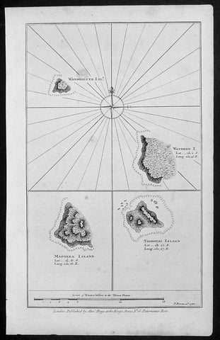
1786 Bowen Antique Map 3 x Cook Islands & 1 x Society Island - Cooks Voyage 1777
- Title : Wanooaette Isl; Wateeoo I; Mangeea Island Toobouai Island
- Size: 13 1/2in x 9 1/2in (345mm x 240mm)
- Ref #: 21697
- Date : 1786
- Condition: (A+) Fine Condition
Description:
This fine original copper-plate engraved antique map of three of the Cook Islands, Takutea (Wanooaette) Atiu (Wateeoo) and Mangaia (Mangeea) and a 4th map of the Island of Tubuai (Toobouai) in French Polynesia near Tahiti, visited by Captain Cook in HMS Resolution & Discovery in September 1777, during his 3rd & last Voyage of Discovery, was published in George Andersons A New, Authentic, and Complete Account of Voyages Round the World, Undertaken and Performed by Royal Authority. Containing a New, Authentic, Entertaining, Instructive, Full and Complete History of Captain Cooks First, Second, Third and Last Voyages.. ... published by Alexander Hogg, London 1786.
These maps of three Cook Islands :
1.Wanooaette, (Takutea)
2. Wateeoo (Atiu)
3. Mangeea ( Mangaia)
4. inset map of Toobouai (Tubuai) in the Society Islands in French Polynesia
All maps were charted by James Cook in 1777 while sailing for the Society Islands (French Polynesia) with livestock he carried aboard the Discovery and the Resolution. As he sailed toward Tahiti he discovered Toobouai (Tubuai) Island on 13 August 1777 where they stayed for 6 weeks. Relief shown by hachures and soundings.
General Definitions:
Paper thickness and quality: - Heavy and stable
Paper color : - off white
Age of map color: -
Colors used: -
General color appearance: -
Paper size: - 13 1/2in x 9 1/2in (345mm x 240mm)
Plate size: - 13 1/2in x 9 1/2in (345mm x 240mm)
Margins: - Min 1/2in (12mm)
Imperfections:
Margins: - None
Plate area: - None
Verso: - None
George William Anderson
A Collection of voyages round the world : performed by royal authority : containing a complete historical account of Captain Cooks first, second, third and last voyages, undertaken for making new discoveries, &c. ... : to which are added genuine narratives of other voyages of discovery round the world, &c. viz. those of Lord Byron, Capt. Wallis, Capt. Carteret, Lord Mulgrave, Lord Anson, Mr. Parkinson, Capt. Lutwidge, Mess. Ives, Middleton, Smith, &c published by Alex. Hogg, 1786.
Spanish ships visited the islands in the 16th century; the first written record of contact with the islands came in 1595 with the sighting of Pukapuka by Spanish sailor Álvaro de Mendaña de Neira, who called it San Bernardo (Saint Bernard). Pedro Fernandes de Queirós, a Portuguese captain working for the Spanish crown, made the first recorded European landing in the islands when he set foot on Rakahanga in 1606, calling it Gente Hermosa.
British navigator Captain James Cook arrived in 1773 and 1777 and named the island of Manuae Hervey Island. Later, the name Hervey Islands came to be applied to the entire southern group; the name Cook Islands, in honour of Cook, first appeared on a Russian naval chart published in the 1820s
Takutea, in the Cook Islands, is a small uninhabited island 21 kilometres northwest of Atiu in the southern Cook Islands.
Takutea is the only island in the Cook Islands that never had a permanent population. When Captain James Cook sighted the island on 4 April 1777, and some crew members went ashore, they found some huts, but no evidence of a permanent settlement.
Atiu, also known as Enuamanu (meaning land of the birds), is an island 187 km northeast of Rarotonga, in the Southern Islands group of the Cook Islands Archipelago.
The first recorded European to arrive at Atiu was Captain Cook. He sighted the island on March 31, 1777 and made tentative contact with some of the people over the next few days.
Mangaia (traditionally known as A ua u Enua, which means terraced) is the most southerly of the Cook Islands and the second largest, after Rarotonga.
The first recorded European to arrive at Mangaia was Captain James Cook on 29 March 1777.
Tubuai part of the Society Islands is located 640 km south of Tahiti. Tubuai was first viewed by Europeans when it was mapped by Captain James Cook in 1777, although his party did not disembark. Cook discovered the islands name, Toobouai, from the natives who surrounded his ship in their canoes (a Tahitian named Omai, who was part of Cooks group, translated)
The next Europeans to arrive were the mutineers of the HMS Bounty in 1789. Mutineer Fletcher Christian, in looking for an island on which to permanently hide, had scoured Blighs maps and nautical charts and decided on Tubuai.
Upon arrival at Tubuai, a conflict arose while the mutineers were still on their ship and several islanders were killed in their canoes. The site of this event in the lagoon on the north side of the island is called Baie Sanglant (Bloody Bay)
1786 Chris. Cellarius Old, Antique Atlas Geographia - w/ 27 Maps and Armillary
- Title : CHRISTOPHORI CELLARII SMALCALDENSIS GEOGRAPHIA ANTIQUA - Recognita denuo & ad veterum novorumque scriptorium fidem, historicorum maxime identidem castigate & Quinta Editione plurimis locis aucta & immutata
- Ref #: 61153
- Size: 8 1/2in x 5 1/2in (21.5cm x 13.5cm)
- Date : 1786
- Condition: (A) Good Condition
Description:
Scarce edition of the Christopher Cellarius unique 1786 Atlas Geographiawith 27 folding maps. Overall condition of the Atlas is Good (see below) with the contents in VG to Fine condition.
Beautiful example of this iconic Atlas complete.
Description: "CHRISTOPHORI CELLARII SMALCALDENSIS GEOGRAPHIA ANTIQUA - Recognita denuo & ad veterum novorumque scriptorium fidem, historicorum maxime identidem castigate & Quinta Editione plurimis locis aucta & immutata - Huic demum Sextae Editioni Tot CHARTAS ex majori auctoris Geographia antiqua quot ad minorem hanc illustrandam requirebantur, DUPLICEMQUE INDICEM QUORUM Priori vetera locorum nomina novis praeponuntur Posteriori nova veteribus, Addidit, totam recensuit & Scholarum usui accommodavit. SAMUEL PATRICK, L.L.D. EDITIO altera & castigatior.LONDINISumptibus J & T. POTE, E. BALLARD, C. BATHURST, J. F. & C. RIVINGTON, T. LONGMAN & G. GINGER M.DCC.LXXXVI" (1786)
Bound in full leather with five raised bands to spine. Volume measures approx. 21.5cm x 13.5cm x 2cm. The front and rear boards are cracked to spine edges and have some movement. Chipped to top and bottom of spine and corners, with small loss. There are a couple of chips to leather. The first page is the title page and last leaf is the last leaf of text. Fixed endpapers are browned.
The title page, and last leaf are browned to edges, and there is an ink mark to last leaf. Couple of leaves and a map are detached. One page has large corner chip, with loss. There are a couple of ink numbers/marks to rear of one of the maps, and the occasional ink mark and splash. Overall the majority of contents are in clean and tight condition.
There are 27 folding maps with armillary Sphere. Atlas content index (see images)
Background: Geographica was one of the most popular geographical publications of the 17th and 18th centuries lasting into the 19th century. (Ref: Tooley; M&B)
General Description:
Paper thickness and quality: - Heavy and stable
Paper color: - off white
Age of map color: -
Colors used: -
General color appearance: -
Atlas size: - 8 1/2in x 5 1/2in (21.5cm x 13.5cm)
Map size: - 9 1/2in x 8 1/2in (23cm x 21.5cm)
Margins: - Min 1/2in (12mm)
Imperfections:
Margins: - See above
Plate area: - See above
Verso: - See above
1786 Du Bocage & Barthelemy Antique Map of Elis Peloponnesos, Greece - Olympia
- Title : L Elide et La Triphylie....1786
- Size: 15in x 10in (380mm x 255mm)
- Ref #: 16451
- Date : 1786
- Condition: (A+) Fine Condition
Description:
This original copper-plate engraved map by Jean Denis Barbie du Bocage was engraved in 1785 - dated in the title - and was published in the 1787 edition of Jean-Jacques Barthelemy famous Voyage du jeune Anarcharsis en Grece or Travels of Anacharsis the younger in Greecein 4 volumes.
General Definitions:
Paper thickness and quality: - Heavy and stable
Paper color : - off white
Age of map color: -
Colors used: -
General color appearance: -
Paper size: - 15in x 10in (380mm x 255mm)
Plate size: - 8 1/2in x 7 1/2in (215mm x 190mm)
Margins: - Min 1in (25mm)
Imperfections:
Margins: - None
Plate area: - Folds as issued
Verso: - None
Background:
Jean-Jacques Barthelemy 1716 – 1795 was a French writer and numismatist.
Barthelemy was the author of a number of learned works on antiquarian subjects, but the great work on which his fame rests is Travels of Anacharsis the younger in Greece (French: Voyage du jeune Anarcharsis en Grece, 4 vols., 1787). He had begun it in 1757 and had been working on it for thirty years. The hero, a young Scythian descended from the famous philosopher Anacharsis, is supposed to repair to Greece for instruction in his early youth, and after making the tour of her republics, colonies and islands, to return to his native country and write this book in his old age, after the Macedonian hero had overturned the Persian empire. In the manner of modern travellers, he gives an account of the customs, government, and antiquities of the country he is supposed to have visited. A copious introduction supplies whatever may be wanting in respect to historical details, while various dissertations on the music of the Greeks, on the literature of the Athenians, and on the economy, pursuits, ruling passions, manners, and customs of the surrounding states supply ample information on the subjects of which they treat.
Modern scholarship has superseded most of the details in the Voyage, but the author himself did not imagine his book to be a register of accurately ascertained facts. Rather, he intended to afford to his countrymen, in an interesting form, some knowledge of Greek civilisation. The Charicles, or Illustrations of the Private Life of the Ancient Greeks of Wilhelm Adolf Becker is an attempt in a similar direction
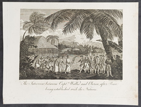
1787 Bankes Antique Print Capt. Wallis making peace with Queen Purea of Tahiti in 1767
- Title : The Interview bewteen Capt Wallis and Oberea after Peace being established with the Natives
- Size: 9 1/2in x 7 1/2in (240mm x 190mm)
- Ref #: 21662
- Date : 1787
- Condition: (A+) Fine Condition
Description:
This fine original cooper-plate engraved antique print of Captain Samuel Wallis negotiating Peace Terms with Queen Purea (Oberea) of Tahiti in 1767 (please read more below) was published in Thomas Bankes 1787 edition of A New, Royal and Authentic System of Universal Geography, Antient and Modern..... printed by Charles Cook, London.
General Definitions:
Paper thickness and quality: - Heavy and stable
Paper color : - off white
Age of map color: -
Colors used: -
General color appearance: -
Paper size: - 9 1/2in x 7 1/2in (240mm x 190mm)
Plate size: - 9 1/2in x 7 1/2in (240mm x 190mm)
Margins: - Min 1/2in (12mm)
Imperfections:
Margins: - None
Plate area: - None
Verso: - None
Background:
Tahiti previously also known as Otaheite is the largest island in the Windward group of French Polynesia. The island is located in the archipelago of the Society Islands in the central Southern Pacific Ocean.
The first European to have visited Tahiti according to existing records was lieutenant Samuel Wallis, who was circumnavigating the globe in HMS Dolphin, sighting the island on 18 June 1767, and eventually harboring in Matavai Bay. This bay was situated on the territory of the chiefdom of Pare-Arue, governed by Tu (Tu-nui-e-a\\\\\\\'a-i-te-Atua) and his regent Tutaha, and the chiefdom of Ha apape, governed by Amo and his wife Oberea (Purea). Wallis named the island King Georges Island. The first contacts were difficult, since on the 24 and 26 June 1767, Tahitian warriors in canoes showed aggression towards the British, hurling stones from their slings. In retaliation, the British sailors opened fire on the warriors in the canoes and on the hills. In reaction to this powerful counter-attack, the Tahitians laid down peace offerings for the British. Following this episode, Samuel Wallis was able to establish cordial relations with the female chieftain “Oberea “ (Purea) and remained on the island until 27 July 1767.
In July 1768, Captain James Cook was commissioned by the Royal Society and on orders from the Lords Commissioners of the Admiralty to observe the transit of Venus across the sun, a phenomenon that would be visible from Tahiti on 3 June 1769. He arrived in Tahitis Matavai Bay, commanding the HMS Endeavour on 12 April 1769. On 14 April, Cook met with Tutaha and Tepau. On 15 April, Cook picked the site for a fortified camp at Point Venus along with Banks, Parkinson, Daniel Solander, to protect Charles Greens observatory. The length of stay enabled them to undertake for the first time real ethnographic and scientific observations of the island. Assisted by the botanist Joseph Banks, and by the artist Sydney Parkinson, Cook gathered valuable information on the fauna and flora, as well as the native society, language and customs, including the proper name of the island, Otaheite. On 28 April, Cook met Purea and Tupaia, and Tupaia befriended Banks following the transit. On 21 June, Amo visited Cook, and then on 25 June, Pohuetea visited, signifying another chief seeking to ally himself with the British.
Cook and Banks circumnavigated the island from 26 June to 1 July. On the exploration, they met Ahio, chief of Ha apaiano o or Papenoo, Rita, chief of Hitia a, Pahairro, chief of Pueu, Vehiatua, chief of Tautra, Matahiapo, chief of Teahupo o, Tutea, chief of Vaira o, and Moe, chief of Afa\\\\\\\'Ahiti. In Papara, guided by Tupaia, they investigated the ruins of Mahaiatea marae, an impressive structure containing a stone pyramid or ahu, measuring 44 feet high, 267 feet long and 87 feet wide. Cook and the Endeavour departed Tahiti on 13 July 1769, taking Raiatean navigator Tupaia along for his geographic knowledge of the islands.
Cook returned to Tahiti between 15 August and 1 September 1773, greeted by the chiefs Tai and Puhi, besides the youg ari i Vehiatua II and his stepfather Ti itorea. Cook anchored in Vaitepiha Bay before returning to Point Venus where he met Tu, the paramount chief. Cook picked up two passengers from Tahiti during this trip, Porea and Ma\\\\\\\'i, with Hitihiti later replacing Porea when Cook stopped at Raiatea. Cook took Hitihiti to Tahiti on 22 April, during his return leg. Then, Cook departed Tahiti on 14 May 1774.
During his final visit, Cook returned Mai to Tahiti on 12 Aug. 1777, after Mais long visit in England. Cook also brought two Maori from Queen Charlotte Sound, Te Weherua and Koa. Cook first harbored in Vaitepiha Bay, where he visited Vehiatua II s funeral bier and the prefabricated Spanish mission house. Cook also met Vehiatua III, and inscribed on the back of the Spanish cross, Georgius tertius Rex Annis 1767, 69, 73, 74 & 77, as a counterpoint to Christus Vincit Carolus III imperat 1774 on the front. On 23 Aug., Cook sailed for Matavai Bay, where he met Tu, his father Teu, his mother Tetupaia, his brothers Ari ipaea and Vaetua, and his sisters Ari ipaea-vahine, Tetua-te-ahamai, and Auo. Cook also observed a human sacrifice, taata tapu, at the Utu-ai-mahurau marae, and 49 skulls from previous victims.
On 29 Sept. 1777, Cook sailed for Papetoai Bay on Moorea. Cook met Mahine in an act of friendship on 3 Oct., though he was an enemy of Tu. When a goat kid was stolen on 6 Oct., Cook in a rampage, ordered the burning of houses and canoes until it was returned. Cook sailed for Huahine on 11 Oct., Raiatea on 2 Nov., and Borabora on 7 Dec.
On 26 October 1788, HMS Bounty, under the command of Captain William Bligh, landed in Tahiti with the mission of carrying Tahitian breadfruit trees (Tahitian: uru) to the Caribbean. Sir Joseph Banks, the botanist from James Cooks first expedition, had concluded that this plant would be ideal to feed the African slaves working in the Caribbean plantations at very little cost. The crew remained in Tahiti for about five months, the time needed to transplant the seedlings of the trees. Three weeks after leaving Tahiti, on 28 April 1789, the crew mutinied on the initiative of Fletcher Christian. The mutineers seized the ship and set the captain and most of those members of the crew who remained loyal to him adrift in a ship\\\\\\\'s boat. A group of mutineers then went back to settle in Tahiti.
Although various explorers had refused to get involved in tribal conflicts, the mutineers from the Bounty offered their services as mercenaries and furnished arms to the family which became the Pōmare Dynasty. The chief Tū knew how to use their presence in the harbours favoured by sailors to his advantage. As a result of his alliance with the mutineers, he succeeded in considerably increasing his supremacy over the island of Tahiti.
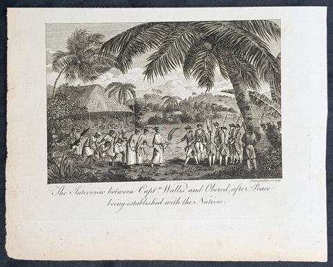
1787 Bankes Antique Print Capt. Wallis making peace with Queen Purea of Tahiti in 1767
- Title : The Interview bewteen Capt Wallis and Oberea after Peace being established with the Natives
- Size: 9 1/2in x 7 1/2in (240mm x 190mm)
- Ref #: 21553-1
- Date : 1787
- Condition: (A+) Fine Condition
Description:
This fine original cooper-plate engraved antique print of Captain Samuel Wallis negotiating Peace Terms with Queen Purea (Oberea) of Tahiti in 1767 (please read more below) was published in Thomas Bankes 1787 edition of A New, Royal and Authentic System of Universal Geography, Antient and Modern..... printed by Charles Cook, London.
General Definitions:
Paper thickness and quality: - Heavy and stable
Paper color : - off white
Age of map color: -
Colors used: -
General color appearance: -
Paper size: - 9 1/2in x 7 1/2in (240mm x 190mm)
Plate size: - 9 1/2in x 7 1/2in (240mm x 190mm)
Margins: - Min 1/2in (12mm)
Imperfections:
Margins: - None
Plate area: - None
Verso: - None
Background:
Tahiti previously also known as Otaheite is the largest island in the Windward group of French Polynesia. The island is located in the archipelago of the Society Islands in the central Southern Pacific Ocean.
The first European to have visited Tahiti according to existing records was lieutenant Samuel Wallis, who was circumnavigating the globe in HMS Dolphin, sighting the island on 18 June 1767, and eventually harboring in Matavai Bay. This bay was situated on the territory of the chiefdom of Pare-Arue, governed by Tu (Tu-nui-e-a\\\\\\\'a-i-te-Atua) and his regent Tutaha, and the chiefdom of Ha apape, governed by Amo and his wife Oberea (Purea). Wallis named the island King Georges Island. The first contacts were difficult, since on the 24 and 26 June 1767, Tahitian warriors in canoes showed aggression towards the British, hurling stones from their slings. In retaliation, the British sailors opened fire on the warriors in the canoes and on the hills. In reaction to this powerful counter-attack, the Tahitians laid down peace offerings for the British. Following this episode, Samuel Wallis was able to establish cordial relations with the female chieftain “Oberea “ (Purea) and remained on the island until 27 July 1767.
In July 1768, Captain James Cook was commissioned by the Royal Society and on orders from the Lords Commissioners of the Admiralty to observe the transit of Venus across the sun, a phenomenon that would be visible from Tahiti on 3 June 1769. He arrived in Tahitis Matavai Bay, commanding the HMS Endeavour on 12 April 1769. On 14 April, Cook met with Tutaha and Tepau. On 15 April, Cook picked the site for a fortified camp at Point Venus along with Banks, Parkinson, Daniel Solander, to protect Charles Greens observatory. The length of stay enabled them to undertake for the first time real ethnographic and scientific observations of the island. Assisted by the botanist Joseph Banks, and by the artist Sydney Parkinson, Cook gathered valuable information on the fauna and flora, as well as the native society, language and customs, including the proper name of the island, Otaheite. On 28 April, Cook met Purea and Tupaia, and Tupaia befriended Banks following the transit. On 21 June, Amo visited Cook, and then on 25 June, Pohuetea visited, signifying another chief seeking to ally himself with the British.
Cook and Banks circumnavigated the island from 26 June to 1 July. On the exploration, they met Ahio, chief of Ha apaiano o or Papenoo, Rita, chief of Hitia a, Pahairro, chief of Pueu, Vehiatua, chief of Tautra, Matahiapo, chief of Teahupo o, Tutea, chief of Vaira o, and Moe, chief of Afa\\\\\\\'Ahiti. In Papara, guided by Tupaia, they investigated the ruins of Mahaiatea marae, an impressive structure containing a stone pyramid or ahu, measuring 44 feet high, 267 feet long and 87 feet wide. Cook and the Endeavour departed Tahiti on 13 July 1769, taking Raiatean navigator Tupaia along for his geographic knowledge of the islands.
Cook returned to Tahiti between 15 August and 1 September 1773, greeted by the chiefs Tai and Puhi, besides the youg ari i Vehiatua II and his stepfather Ti itorea. Cook anchored in Vaitepiha Bay before returning to Point Venus where he met Tu, the paramount chief. Cook picked up two passengers from Tahiti during this trip, Porea and Ma\\\\\\\'i, with Hitihiti later replacing Porea when Cook stopped at Raiatea. Cook took Hitihiti to Tahiti on 22 April, during his return leg. Then, Cook departed Tahiti on 14 May 1774.
During his final visit, Cook returned Mai to Tahiti on 12 Aug. 1777, after Mais long visit in England. Cook also brought two Maori from Queen Charlotte Sound, Te Weherua and Koa. Cook first harbored in Vaitepiha Bay, where he visited Vehiatua II s funeral bier and the prefabricated Spanish mission house. Cook also met Vehiatua III, and inscribed on the back of the Spanish cross, Georgius tertius Rex Annis 1767, 69, 73, 74 & 77, as a counterpoint to Christus Vincit Carolus III imperat 1774 on the front. On 23 Aug., Cook sailed for Matavai Bay, where he met Tu, his father Teu, his mother Tetupaia, his brothers Ari ipaea and Vaetua, and his sisters Ari ipaea-vahine, Tetua-te-ahamai, and Auo. Cook also observed a human sacrifice, taata tapu, at the Utu-ai-mahurau marae, and 49 skulls from previous victims.
On 29 Sept. 1777, Cook sailed for Papetoai Bay on Moorea. Cook met Mahine in an act of friendship on 3 Oct., though he was an enemy of Tu. When a goat kid was stolen on 6 Oct., Cook in a rampage, ordered the burning of houses and canoes until it was returned. Cook sailed for Huahine on 11 Oct., Raiatea on 2 Nov., and Borabora on 7 Dec.
On 26 October 1788, HMS Bounty, under the command of Captain William Bligh, landed in Tahiti with the mission of carrying Tahitian breadfruit trees (Tahitian: uru) to the Caribbean. Sir Joseph Banks, the botanist from James Cooks first expedition, had concluded that this plant would be ideal to feed the African slaves working in the Caribbean plantations at very little cost. The crew remained in Tahiti for about five months, the time needed to transplant the seedlings of the trees. Three weeks after leaving Tahiti, on 28 April 1789, the crew mutinied on the initiative of Fletcher Christian. The mutineers seized the ship and set the captain and most of those members of the crew who remained loyal to him adrift in a ship\\\\\\\'s boat. A group of mutineers then went back to settle in Tahiti.
Although various explorers had refused to get involved in tribal conflicts, the mutineers from the Bounty offered their services as mercenaries and furnished arms to the family which became the Pōmare Dynasty. The chief Tū knew how to use their presence in the harbours favoured by sailors to his advantage. As a result of his alliance with the mutineers, he succeeded in considerably increasing his supremacy over the island of Tahiti.
1787 Bankes Antique Print Capt. Wallis making peace with Queen Purea of Tahiti in 1767
- Title : The Interview bewteen Capt Wallis and Oberea after Peace being established with the Natives
- Size: 9 1/2in x 7 1/2in (240mm x 190mm)
- Ref #: 21524
- Date : 1787
- Condition: (A+) Fine Condition
Description:
This fine original cooper-plate engraved antique print of Captain Samuel Wallis negotiating Peace Terms with Queen Purea (Oberea) of Tahiti in 1767 (please read more below) was published in Thomas Bankes 1787 edition of A New, Royal and Authentic System of Universal Geography, Antient and Modern..... printed by Charles Cook, London.
General Definitions:
Paper thickness and quality: - Heavy and stable
Paper color : - off white
Age of map color: -
Colors used: -
General color appearance: -
Paper size: - 9 1/2in x 7 1/2in (240mm x 190mm)
Plate size: - 9 1/2in x 7 1/2in (240mm x 190mm)
Margins: - Min 1/2in (12mm)
Imperfections:
Margins: - None
Plate area: - None
Verso: - None
Background:
Tahiti previously also known as Otaheite is the largest island in the Windward group of French Polynesia. The island is located in the archipelago of the Society Islands in the central Southern Pacific Ocean.
The first European to have visited Tahiti according to existing records was lieutenant Samuel Wallis, who was circumnavigating the globe in HMS Dolphin, sighting the island on 18 June 1767, and eventually harboring in Matavai Bay. This bay was situated on the territory of the chiefdom of Pare-Arue, governed by Tu (Tu-nui-e-a\\\\\\\'a-i-te-Atua) and his regent Tutaha, and the chiefdom of Ha apape, governed by Amo and his wife Oberea (Purea). Wallis named the island King Georges Island. The first contacts were difficult, since on the 24 and 26 June 1767, Tahitian warriors in canoes showed aggression towards the British, hurling stones from their slings. In retaliation, the British sailors opened fire on the warriors in the canoes and on the hills. In reaction to this powerful counter-attack, the Tahitians laid down peace offerings for the British. Following this episode, Samuel Wallis was able to establish cordial relations with the female chieftain “Oberea “ (Purea) and remained on the island until 27 July 1767.
In July 1768, Captain James Cook was commissioned by the Royal Society and on orders from the Lords Commissioners of the Admiralty to observe the transit of Venus across the sun, a phenomenon that would be visible from Tahiti on 3 June 1769. He arrived in Tahitis Matavai Bay, commanding the HMS Endeavour on 12 April 1769. On 14 April, Cook met with Tutaha and Tepau. On 15 April, Cook picked the site for a fortified camp at Point Venus along with Banks, Parkinson, Daniel Solander, to protect Charles Greens observatory. The length of stay enabled them to undertake for the first time real ethnographic and scientific observations of the island. Assisted by the botanist Joseph Banks, and by the artist Sydney Parkinson, Cook gathered valuable information on the fauna and flora, as well as the native society, language and customs, including the proper name of the island, Otaheite. On 28 April, Cook met Purea and Tupaia, and Tupaia befriended Banks following the transit. On 21 June, Amo visited Cook, and then on 25 June, Pohuetea visited, signifying another chief seeking to ally himself with the British.
Cook and Banks circumnavigated the island from 26 June to 1 July. On the exploration, they met Ahio, chief of Ha apaiano o or Papenoo, Rita, chief of Hitia a, Pahairro, chief of Pueu, Vehiatua, chief of Tautra, Matahiapo, chief of Teahupo o, Tutea, chief of Vaira o, and Moe, chief of Afa\\\\\\\'Ahiti. In Papara, guided by Tupaia, they investigated the ruins of Mahaiatea marae, an impressive structure containing a stone pyramid or ahu, measuring 44 feet high, 267 feet long and 87 feet wide. Cook and the Endeavour departed Tahiti on 13 July 1769, taking Raiatean navigator Tupaia along for his geographic knowledge of the islands.
Cook returned to Tahiti between 15 August and 1 September 1773, greeted by the chiefs Tai and Puhi, besides the youg ari i Vehiatua II and his stepfather Ti itorea. Cook anchored in Vaitepiha Bay before returning to Point Venus where he met Tu, the paramount chief. Cook picked up two passengers from Tahiti during this trip, Porea and Ma\\\\\\\'i, with Hitihiti later replacing Porea when Cook stopped at Raiatea. Cook took Hitihiti to Tahiti on 22 April, during his return leg. Then, Cook departed Tahiti on 14 May 1774.
During his final visit, Cook returned Mai to Tahiti on 12 Aug. 1777, after Mais long visit in England. Cook also brought two Maori from Queen Charlotte Sound, Te Weherua and Koa. Cook first harbored in Vaitepiha Bay, where he visited Vehiatua II s funeral bier and the prefabricated Spanish mission house. Cook also met Vehiatua III, and inscribed on the back of the Spanish cross, Georgius tertius Rex Annis 1767, 69, 73, 74 & 77, as a counterpoint to Christus Vincit Carolus III imperat 1774 on the front. On 23 Aug., Cook sailed for Matavai Bay, where he met Tu, his father Teu, his mother Tetupaia, his brothers Ari ipaea and Vaetua, and his sisters Ari ipaea-vahine, Tetua-te-ahamai, and Auo. Cook also observed a human sacrifice, taata tapu, at the Utu-ai-mahurau marae, and 49 skulls from previous victims.
On 29 Sept. 1777, Cook sailed for Papetoai Bay on Moorea. Cook met Mahine in an act of friendship on 3 Oct., though he was an enemy of Tu. When a goat kid was stolen on 6 Oct., Cook in a rampage, ordered the burning of houses and canoes until it was returned. Cook sailed for Huahine on 11 Oct., Raiatea on 2 Nov., and Borabora on 7 Dec.
On 26 October 1788, HMS Bounty, under the command of Captain William Bligh, landed in Tahiti with the mission of carrying Tahitian breadfruit trees (Tahitian: uru) to the Caribbean. Sir Joseph Banks, the botanist from James Cooks first expedition, had concluded that this plant would be ideal to feed the African slaves working in the Caribbean plantations at very little cost. The crew remained in Tahiti for about five months, the time needed to transplant the seedlings of the trees. Three weeks after leaving Tahiti, on 28 April 1789, the crew mutinied on the initiative of Fletcher Christian. The mutineers seized the ship and set the captain and most of those members of the crew who remained loyal to him adrift in a ship\\\\\\\'s boat. A group of mutineers then went back to settle in Tahiti.
Although various explorers had refused to get involved in tribal conflicts, the mutineers from the Bounty offered their services as mercenaries and furnished arms to the family which became the Pōmare Dynasty. The chief Tū knew how to use their presence in the harbours favoured by sailors to his advantage. As a result of his alliance with the mutineers, he succeeded in considerably increasing his supremacy over the island of Tahiti.
1787 Bankes Antique Print English or Nanwalek Bay Alaska, Cooks 3rd Voyage 1778
- Title : View of Oonalashka and the Inhabitants
- Size: 14in x 9in (355mm x 230mm)
- Ref #: 40213
- Date : 1787
- Condition: (A) Very Good Condition
Description:
This fine original cooper-plate engraved antique print a view of English or Nanwalek Bay, Alaska visited by Captain James Cook in June/July 1778, during his third voyage of discovery - after John Webber - was published in Thomas Bankes 1787 edition of A New, Royal and Authentic System of Universal Geography, Antient and Modern..... printed by Charles Cook, London.
Cooks Third Voyage (1776-1779)
In the course of his first two voyages, Cook circumnavigated the globe twice, sailed extensively into the Antarctic, and charted coastlines from Newfoundland to New Zealand. Following these achievements, Cook\'s third voyage was organized to seek an efficient route from England to southern and eastern Asia that would not entail rounding the Cape of Good Hope. The search for such a Northwest (or Northeast) Passage had been on the agenda of northern European mariners and merchants since the beginning of European expansion in the late fifteenth century. England\'s growing economic and colonial interests in India in the later eighteenth century provided the stimulus for the latest exploration for this route.
Cook, again in command of the Resolution, was to approach the Northwest Passage from the Pacific accompanied by a second ship, the Discovery, captained by Charles Clerke. The ships left England separately, regrouped at Cape Town, and continued on to Tasmania, New Zealand, and Tahiti. The expedition then sailed north and made landfall at Christmas Island and the Hawaiian Islands. Cook continued northward and charted the west coast of North America from Northern California as far as the Bering Strait. He returned to Hawaii for the winter and was killed in a skirmish with natives on February 14, 1779. Upon Cook\'s death, Clerke took command of the expedition but died six months later. The ships returned to England in 1780 under John Gore, who had commanded the Discovery after Cook\'s death. From start to finish, the voyage had lasted more than four years. (Ref Tooley; M&B; Clancy)
General Definitions:
Paper thickness and quality: - Heavy and stable
Paper color : - off white
Age of map color: -
Colors used: -
General color appearance: -
Paper size: - 14in x 9in (355mm x 230mm)
Plate size: - 12in x 7 1/2in (305mm x 190mm)
Margins: - Min 1/2in (12mm)
Imperfections:
Margins: - None
Plate area: - None
Verso: - None
Background:
Nanwalek, formerly Alexandrovsk and English Bay, Alaska is census-designated place (CDP) in the Kenai Peninsula Borough, Alaska, United States that contains a traditional Alutiiq village.
Cooks Diary.......English Bay, Unalaska......the next day, the 27th, wrote Cook the fog partly despersed. At 7 AM wieghed and steered to the North… the wind faild and obliged us to Anchor. They sailed on and anchored in a bay for a few days on 28th. According to Samwell the next day We hoisted out our launch sent her ashore to fill the empty Water Casks both Ships completed their water. On 30th Many Canoes trading about the Ship… We find many Notes written in the Russian Language among these People dated in the Year 1776. The weather was, wrote Samwell moderate & hazy
1787 Bankes Antique Print Human Sacrifice at Māori Tahiti - Cooks 3rd Voyage 1777
- Title : A Human Sacrifice in a Morai in Otaheite
- Size: 9 1/2in x 7 1/2in (240mm x 190mm)
- Ref #: 21624-1
- Date : 1787
- Condition: (A+) Fine Condition
Description:
This fine original cooper-plate engraved antique print of a Human Sacrifice at the Utu-ai-mahurau Marae on Tahiti witnessed by Captain Cooks during his 3rd Voyage of Discovery to the South Seas in 1777 was published in Thomas Bankes 1787 edition of A New, Royal and Authentic System of Universal Geography, Antient and Modern..... printed by Charles Cook, London.
General Definitions:
Paper thickness and quality: - Heavy and stable
Paper color : - off white
Age of map color: -
Colors used: -
General color appearance: -
Paper size: - 9 1/2in x 7 1/2in (240mm x 190mm)
Plate size: - 9 1/2in x 7 1/2in (240mm x 190mm)
Margins: - Min 1/2in (12mm)
Imperfections:
Margins: - None
Plate area: - None
Verso: - None
Background:
CooksThird Voyage (1776–79)
On his last voyage, Cook again commanded HMS Resolution, while Captain Charles Clerke commanded HMS Discovery. The voyage was ostensibly planned to return the Pacific Islander, Omai to Tahiti, or so the public were led to believe. The trip\\\'s principal goal was to locate a Northwest Passage around the American continent. After dropping Omai at Tahiti, Cook travelled north and in 1778 became the first European to begin formal contact with the Hawaiian Islands. After his initial landfall in January 1778 at Waimea harbour, Kauai, Cook named the archipelago the \\\"Sandwich Islands\\\" after the fourth Earl of Sandwich—the acting First Lord of the Admiralty.
From the Sandwich Islands Cook sailed north and then north-east to explore the west coast of North America north of the Spanish settlements in Alta California. He made landfall on the Oregon coast at approximately 44°30′ north latitude, naming his landing point Cape Foulweather. Bad weather forced his ships south to about 43° north before they could begin their exploration of the coast northward. He unknowingly sailed past the Strait of Juan de Fuca, and soon after entered Nootka Sound on Vancouver Island. He anchored near the First Nations village of Yuquot. Cook\\\'s two ships remained in Nootka Sound from 29 March to 26 April 1778, in what Cook called Ship Cove, now Resolution Cove, at the south end of Bligh Island, about 5 miles (8 km) east across Nootka Sound from Yuquot, lay a Nuu-chah-nulth village (whose chief Cook did not identify but may have been Maquinna). Relations between Cook\\\'s crew and the people of Yuquot were cordial if sometimes strained. In trading, the people of Yuquot demanded much more valuable items than the usual trinkets that had worked in Hawaii. Metal objects were much desired, but the lead, pewter, and tin traded at first soon fell into disrepute. The most valuable items which the British received in trade were sea otter pelts. During the stay, the Yuquot \\\"hosts\\\" essentially controlled the trade with the British vessels; the natives usually visited the British vessels at Resolution Cove instead of the British visiting the village of Yuquot at Friendly Cove.
After leaving Nootka Sound, Cook explored and mapped the coast all the way to the Bering Strait, on the way identifying what came to be known as Cook Inlet in Alaska. In a single visit, Cook charted the majority of the North American north-west coastline on world maps for the first time, determined the extent of Alaska, and closed the gaps in Russian (from the West) and Spanish (from the South) exploratory probes of the Northern limits of the Pacific.
By the second week of August 1778 Cook was through the Bering Strait, sailing into the Chukchi Sea. He headed north-east up the coast of Alaska until he was blocked by sea ice. His furthest north was 70 degrees 44 minutes. Cook then sailed west to the Siberian coast, and then south-east down the Siberian coast back to the Bering Strait. By early September 1778 he was back in the Bering Sea to begin the trip to the Sandwich (Hawaiian) Islands. He became increasingly frustrated on this voyage, and perhaps began to suffer from a stomach ailment; it has been speculated that this led to irrational behaviour towards his crew, such as forcing them to eat walrus meat, which they had pronounced inedible.
Cook returned to Hawaii in 1779. After sailing around the archipelago for some eight weeks, he made landfall at Kealakekua Bay, on \\\'Hawaii Island\\\', largest island in the Hawaiian Archipelago. Cook\\\'s arrival coincided with the Makahiki, a Hawaiian harvest festival of worship for the Polynesian god Lono. Coincidentally the form of Cook\\\'s ship, HMS Resolution, or more particularly the mast formation, sails and rigging, resembled certain significant artefacts that formed part of the season of worship. Similarly, Cook\\\'s clockwise route around the island of Hawaii before making landfall resembled the processions that took place in a clockwise direction around the island during the Lono festivals. It has been argued (most extensively by Marshall Sahlins) that such coincidences were the reasons for Cook\\\'s (and to a limited extent, his crew\\\'s) initial deification by some Hawaiians who treated Cook as an incarnation of Lono. Though this view was first suggested by members of Cook\\\'s expedition, the idea that any Hawaiians understood Cook to be Lono, and the evidence presented in support of it, were challenged in 1992.
After a month\\\'s stay, Cook attempted to resume his exploration of the Northern Pacific. Shortly after leaving Hawaii Island, however, the Resolution\\\'s foremast broke, so the ships returned to Kealakekua Bay for repairs.
Tensions rose, and a number of quarrels broke out between the Europeans and Hawaiians at Kealakekua Bay. An unknown group of Hawaiians took one of Cook\\\'s small boats. The evening when the cutter was taken, the people had become \\\"insolent\\\" even with threats to fire upon them. Cook was forced into a wild goose chase that ended with his return to the ship frustrated.[53] He attempted to kidnap and ransom the King of Hawaiʻi, Kalaniʻōpuʻu.
That following day, 14 February 1779, Cook marched through the village to retrieve the King. Cook took the King (aliʻi nui) by his own hand and led him willingly away. One of Kalaniʻōpuʻu\\\'s favorite wives, Kanekapolei and two chiefs approached the group as they were heading to boats. They pleaded with the king not to go until he stopped and sat where he stood. An old kahuna (priest), chanting rapidly while holding out a coconut, attempted to distract Cook and his men as a large crowd began to form at the shore. The king began to understand that Cook was his enemy. As Cook turned his back to help launch the boats, he was struck on the head by the villagers and then stabbed to death as he fell on his face in the surf. He was first struck on the head with a club by a chief named Kalaimanokahoʻowaha or Kanaʻina (namesake of Charles Kana\\\'ina) and then stabbed by one of the king\\\'s attendants, Nuaa. The Hawaiians carried his body away towards the back of the town, still visible to the ship through their spyglass. Four marines, Corporal James Thomas, Private Theophilus Hinks, Private Thomas Fatchett and Private John Allen, were also killed and two others were wounded in the confrontation.
The esteem which the islanders nevertheless held for Cook caused them to retain his body. Following their practice of the time, they prepared his body with funerary rituals usually reserved for the chiefs and highest elders of the society. The body was disembowelled, baked to facilitate removal of the flesh, and the bones were carefully cleaned for preservation as religious icons in a fashion somewhat reminiscent of the treatment of European saints in the Middle Ages. Some of Cook\\\'s remains, thus preserved, were eventually returned to his crew for a formal burial at sea.
Clerke assumed leadership of the expedition, and made a final attempt to pass through the Bering Strait. He died from tuberculosis on 22 August 1779 and John Gore, a veteran of Cook\\\'s first voyage, took command of Resolution and of the expedition. James King replaced Gore in command of Discovery. The expedition returned home, reaching England in October 1780. After their arrival in England, King completed Cook\\\'s account of the voyage.
David Samwell, who sailed with Cook on Resolution, wrote of him: \\\"He was a modest man, and rather bashful; of an agreeable lively conversation, sensible and intelligent. In temper he was somewhat hasty, but of a disposition the most friendly, benevolent and humane. His person was above six feet high: and, though a good looking man, he was plain both in dress and appearance. His face was full of expression: his nose extremely well shaped: his eyes which were small and of a brown cast, were quick and piercing; his eyebrows prominent, which gave his countenance altogether an air of austerity.
Tahiti previously also known as Otaheite is the largest island in the Windward group of French Polynesia. The island is located in the archipelago of the Society Islands in the central Southern Pacific Ocean.
The first European to have visited Tahiti according to existing records was lieutenant Samuel Wallis, who was circumnavigating the globe in HMS Dolphin, sighting the island on 18 June 1767, and eventually harboring in Matavai Bay. This bay was situated on the territory of the chiefdom of Pare-Arue, governed by Tu (Tu-nui-e-a\\\\\\\'a-i-te-Atua) and his regent Tutaha, and the chiefdom of Ha apape, governed by Amo and his wife Oberea (Purea). Wallis named the island King Georges Island. The first contacts were difficult, since on the 24 and 26 June 1767, Tahitian warriors in canoes showed aggression towards the British, hurling stones from their slings. In retaliation, the British sailors opened fire on the warriors in the canoes and on the hills. In reaction to this powerful counter-attack, the Tahitians laid down peace offerings for the British. Following this episode, Samuel Wallis was able to establish cordial relations with the female chieftain “Oberea “ (Purea) and remained on the island until 27 July 1767.
In July 1768, Captain James Cook was commissioned by the Royal Society and on orders from the Lords Commissioners of the Admiralty to observe the transit of Venus across the sun, a phenomenon that would be visible from Tahiti on 3 June 1769. He arrived in Tahitis Matavai Bay, commanding the HMS Endeavour on 12 April 1769. On 14 April, Cook met with Tutaha and Tepau. On 15 April, Cook picked the site for a fortified camp at Point Venus along with Banks, Parkinson, Daniel Solander, to protect Charles Greens observatory. The length of stay enabled them to undertake for the first time real ethnographic and scientific observations of the island. Assisted by the botanist Joseph Banks, and by the artist Sydney Parkinson, Cook gathered valuable information on the fauna and flora, as well as the native society, language and customs, including the proper name of the island, Otaheite. On 28 April, Cook met Purea and Tupaia, and Tupaia befriended Banks following the transit. On 21 June, Amo visited Cook, and then on 25 June, Pohuetea visited, signifying another chief seeking to ally himself with the British.
Cook and Banks circumnavigated the island from 26 June to 1 July. On the exploration, they met Ahio, chief of Ha apaiano o or Papenoo, Rita, chief of Hitia a, Pahairro, chief of Pueu, Vehiatua, chief of Tautra, Matahiapo, chief of Teahupo o, Tutea, chief of Vaira o, and Moe, chief of Afa\\\\\\\'Ahiti. In Papara, guided by Tupaia, they investigated the ruins of Mahaiatea marae, an impressive structure containing a stone pyramid or ahu, measuring 44 feet high, 267 feet long and 87 feet wide. Cook and the Endeavour departed Tahiti on 13 July 1769, taking Raiatean navigator Tupaia along for his geographic knowledge of the islands.
Cook returned to Tahiti between 15 August and 1 September 1773, greeted by the chiefs Tai and Puhi, besides the youg ari i Vehiatua II and his stepfather Ti itorea. Cook anchored in Vaitepiha Bay before returning to Point Venus where he met Tu, the paramount chief. Cook picked up two passengers from Tahiti during this trip, Porea and Ma\\\\\\\'i, with Hitihiti later replacing Porea when Cook stopped at Raiatea. Cook took Hitihiti to Tahiti on 22 April, during his return leg. Then, Cook departed Tahiti on 14 May 1774.
During his final visit, Cook returned Mai to Tahiti on 12 Aug. 1777, after Mais long visit in England. Cook also brought two Maori from Queen Charlotte Sound, Te Weherua and Koa. Cook first harbored in Vaitepiha Bay, where he visited Vehiatua II s funeral bier and the prefabricated Spanish mission house. Cook also met Vehiatua III, and inscribed on the back of the Spanish cross, Georgius tertius Rex Annis 1767, 69, 73, 74 & 77, as a counterpoint to Christus Vincit Carolus III imperat 1774 on the front. On 23 Aug., Cook sailed for Matavai Bay, where he met Tu, his father Teu, his mother Tetupaia, his brothers Ari ipaea and Vaetua, and his sisters Ari ipaea-vahine, Tetua-te-ahamai, and Auo. Cook also observed a human sacrifice, taata tapu, at the Utu-ai-mahurau marae, and 49 skulls from previous victims.
On 29 Sept. 1777, Cook sailed for Papetoai Bay on Moorea. Cook met Mahine in an act of friendship on 3 Oct., though he was an enemy of Tu. When a goat kid was stolen on 6 Oct., Cook in a rampage, ordered the burning of houses and canoes until it was returned. Cook sailed for Huahine on 11 Oct., Raiatea on 2 Nov., and Borabora on 7 Dec.
On 26 October 1788, HMS Bounty, under the command of Captain William Bligh, landed in Tahiti with the mission of carrying Tahitian breadfruit trees (Tahitian: uru) to the Caribbean. Sir Joseph Banks, the botanist from James Cooks first expedition, had concluded that this plant would be ideal to feed the African slaves working in the Caribbean plantations at very little cost. The crew remained in Tahiti for about five months, the time needed to transplant the seedlings of the trees. Three weeks after leaving Tahiti, on 28 April 1789, the crew mutinied on the initiative of Fletcher Christian. The mutineers seized the ship and set the captain and most of those members of the crew who remained loyal to him adrift in a ship\\\\\\\'s boat. A group of mutineers then went back to settle in Tahiti.
Although various explorers had refused to get involved in tribal conflicts, the mutineers from the Bounty offered their services as mercenaries and furnished arms to the family which became the Pōmare Dynasty. The chief Tū knew how to use their presence in the harbours favoured by sailors to his advantage. As a result of his alliance with the mutineers, he succeeded in considerably increasing his supremacy over the island of Tahiti.
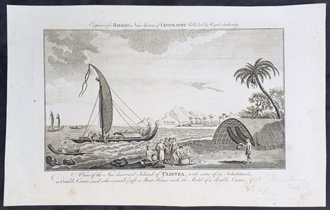
1787 Bankes Antique Print Island of Raiatea, French Polynesia Cooks Voyages 1769
- Title : View of the new discoverd island of Ulietea, with some of its inhabitants, a double canoe, and other small craft, a boat house with the model of a double canoe, & c.
- Size: 14in x 9in (355mm x 230mm)
- Ref #: 21479
- Date : 1787
- Condition: (A+) Fine Condition
Description:
This fine original cooper-plate engraved antique print of a view of the Island of Raiatea (Ulietea) during Captain Cooks 1st Voyage of discovery to the South Seas in 1769 was published in Thomas Bankes 1787 edition of A New, Royal and Authentic System of Universal Geography, Antient and Modern..... printed by Charles Cook, London.
General Definitions:
Paper thickness and quality: - Heavy and stable
Paper color : - off white
Age of map color: -
Colors used: -
General color appearance: -
Paper size: - 14in x 9in (355mm x 230mm)
Plate size: - 12in x 7 1/2in (305mm x 190mm)
Margins: - Min 1/2in (12mm)
Imperfections:
Margins: - None
Plate area: - None
Verso: - None
Raiatea, is the second largest of the Society Islands, after Tahiti, in French Polynesia. The island is widely regarded as the centre of the eastern islands in ancient Polynesia and it is likely that the organised migrations to Hawaii, Aotearoa and other parts of East Polynesia started at Raiātea.
A traditional name for the island is Havaii, homeland of the Māori people.
The first European to record sighting Ra\'iātea was Pedro Fernandes de Queirós in 1606; it was charted as La Fugitiva The Polynesian navigator, Tupaia, who sailed with explorer James Cook, was born in Ra\'iātea around 1725.
Cook visited Raiatea in 1769 and again in 1773-1774. Omai (c.1751-1780), another young man from Raiātea, traveled with the European explorers to London in 1774 and also served as an interpreter to Captain Cook on his second and third journey.
King Tamatoa VI was the last monarch, reigning from 1884-1888.
Cooks First Voyage (1768-1771)
The first voyage under Captain James Cooks command was primarily of a scientific nature. The expedition on the Endeavour initially sailed to Tahiti to observe the transit of the planet Venus in order to calculate the earth\'s distance from the sun. Cook landed on the South Pacific island in April of 1769 and in June of that year the astronomical observations were successfully completed. In addition to these labors, very good relations with the Tahitians were maintained and the naturalists Joseph Banks and Daniel C. Solander conducted extensive ethnological and botanical research.
Another purpose of the voyage was to explore the South Seas to determine if an inhabitable continent existed in the mid-latitudes of the Southern Hemisphere. Upon leaving Tahiti, Cook named and charted the Society Islands and then continued southwest to New Zealand. His circumnavigation and exploration of that country also resulted in a detailed survey. Cook proceeded to Australia, where he charted the eastern coast for 2,000 miles, naming the area New South Wales. As a result of these surveys, both Australia and New Zealand were annexed by Great Britain. In addition to these explorations, the Endeavour returned to England without a single death from scurvy among its men, an historic feat at the time. The combination of these accomplishments brought Cook prominence, promotion, and the opportunity to lead further expeditions.
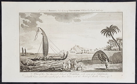
1787 Bankes Antique Print Island of Raiatea, French Polynesia Cooks Voyages 1769
- Title : View of the new discoverd island of Ulietea, with some of its inhabitants, a double canoe, and other small craft, a boat house with the model of a double canoe, & c.
- Size: 14in x 9in (355mm x 230mm)
- Ref #: 21703
- Date : 1787
- Condition: (A+) Fine Condition
Description:
This fine original cooper-plate engraved antique print of a view of the Island of Raiatea (Ulietea) during Captain Cooks 1st Voyage of discovery to the South Seas in 1769 was published in Thomas Bankes 1787 edition of A New, Royal and Authentic System of Universal Geography, Antient and Modern..... printed by Charles Cook, London.
General Definitions:
Paper thickness and quality: - Heavy and stable
Paper color : - off white
Age of map color: -
Colors used: -
General color appearance: -
Paper size: - 14in x 9in (355mm x 230mm)
Plate size: - 12in x 7 1/2in (305mm x 190mm)
Margins: - Min 1/2in (12mm)
Imperfections:
Margins: - None
Plate area: - None
Verso: - None
Raiatea, is the second largest of the Society Islands, after Tahiti, in French Polynesia. The island is widely regarded as the centre of the eastern islands in ancient Polynesia and it is likely that the organised migrations to Hawaii, Aotearoa and other parts of East Polynesia started at Raiātea.
A traditional name for the island is Havaii, homeland of the Māori people.
The first European to record sighting Ra\'iātea was Pedro Fernandes de Queirós in 1606; it was charted as La Fugitiva The Polynesian navigator, Tupaia, who sailed with explorer James Cook, was born in Ra\'iātea around 1725.
Cook visited Raiatea in 1769 and again in 1773-1774. Omai (c.1751-1780), another young man from Raiātea, traveled with the European explorers to London in 1774 and also served as an interpreter to Captain Cook on his second and third journey.
King Tamatoa VI was the last monarch, reigning from 1884-1888.
Cooks First Voyage (1768-1771)
The first voyage under Captain James Cooks command was primarily of a scientific nature. The expedition on the Endeavour initially sailed to Tahiti to observe the transit of the planet Venus in order to calculate the earth\'s distance from the sun. Cook landed on the South Pacific island in April of 1769 and in June of that year the astronomical observations were successfully completed. In addition to these labors, very good relations with the Tahitians were maintained and the naturalists Joseph Banks and Daniel C. Solander conducted extensive ethnological and botanical research.
Another purpose of the voyage was to explore the South Seas to determine if an inhabitable continent existed in the mid-latitudes of the Southern Hemisphere. Upon leaving Tahiti, Cook named and charted the Society Islands and then continued southwest to New Zealand. His circumnavigation and exploration of that country also resulted in a detailed survey. Cook proceeded to Australia, where he charted the eastern coast for 2,000 miles, naming the area New South Wales. As a result of these surveys, both Australia and New Zealand were annexed by Great Britain. In addition to these explorations, the Endeavour returned to England without a single death from scurvy among its men, an historic feat at the time. The combination of these accomplishments brought Cook prominence, promotion, and the opportunity to lead further expeditions.
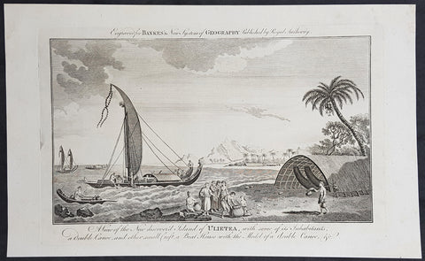
1787 Bankes Antique Print Island of Raiatea, French Polynesia Cooks Voyages 1769
- Title : View of the new discoverd island of Ulietea, with some of its inhabitants, a double canoe, and other small craft, a boat house with the model of a double canoe, & c.
- Size: 14in x 9in (355mm x 230mm)
- Ref #: 40221
- Date : 1787
- Condition: (A+) Fine Condition
Description:
This fine original cooper-plate engraved antique print of a view of the Island of Raiatea (Ulietea) during Captain Cooks 1st Voyage of discovery to the South Seas in 1769 was published in Thomas Bankes 1787 edition of A New, Royal and Authentic System of Universal Geography, Antient and Modern..... printed by Charles Cook, London.
General Definitions:
Paper thickness and quality: - Heavy and stable
Paper color : - off white
Age of map color: -
Colors used: -
General color appearance: -
Paper size: - 14in x 9in (355mm x 230mm)
Plate size: - 12in x 7 1/2in (305mm x 190mm)
Margins: - Min 1/2in (12mm)
Imperfections:
Margins: - None
Plate area: - None
Verso: - None
Raiatea, is the second largest of the Society Islands, after Tahiti, in French Polynesia. The island is widely regarded as the centre of the eastern islands in ancient Polynesia and it is likely that the organised migrations to Hawaii, Aotearoa and other parts of East Polynesia started at Raiātea.
A traditional name for the island is Havaii, homeland of the Māori people.
The first European to record sighting Ra\'iātea was Pedro Fernandes de Queirós in 1606; it was charted as La Fugitiva The Polynesian navigator, Tupaia, who sailed with explorer James Cook, was born in Ra\'iātea around 1725.
Cook visited Raiatea in 1769 and again in 1773-1774. Omai (c.1751-1780), another young man from Raiātea, traveled with the European explorers to London in 1774 and also served as an interpreter to Captain Cook on his second and third journey.
King Tamatoa VI was the last monarch, reigning from 1884-1888.
Cooks First Voyage (1768-1771)
The first voyage under Captain James Cooks command was primarily of a scientific nature. The expedition on the Endeavour initially sailed to Tahiti to observe the transit of the planet Venus in order to calculate the earth\'s distance from the sun. Cook landed on the South Pacific island in April of 1769 and in June of that year the astronomical observations were successfully completed. In addition to these labors, very good relations with the Tahitians were maintained and the naturalists Joseph Banks and Daniel C. Solander conducted extensive ethnological and botanical research.
Another purpose of the voyage was to explore the South Seas to determine if an inhabitable continent existed in the mid-latitudes of the Southern Hemisphere. Upon leaving Tahiti, Cook named and charted the Society Islands and then continued southwest to New Zealand. His circumnavigation and exploration of that country also resulted in a detailed survey. Cook proceeded to Australia, where he charted the eastern coast for 2,000 miles, naming the area New South Wales. As a result of these surveys, both Australia and New Zealand were annexed by Great Britain. In addition to these explorations, the Endeavour returned to England without a single death from scurvy among its men, an historic feat at the time. The combination of these accomplishments brought Cook prominence, promotion, and the opportunity to lead further expeditions.
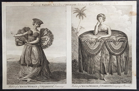
1787 Bankes Antique Print of Dancing Girls & Gifts in Tahiti During Cooks 3rd Voyage, 1777
- Title : Habit of a Young Woman of Otaheite Dancing; Habit of a Young Woman of Otaheite bringing a Present
- Size: 14in x 9in (355mm x 230mm)
- Ref #: 40216
- Date : 1787
- Condition: (A+) Fine Condition
Description:
This fine original cooper-plate engraved antique print of a view of the Island of Nomuka, a small island in the southern part of the Ha apai islands, in the Kingdom of Tonga, during Captain Cooks 3rd Voyage of discovery to the South Seas in 1777 was published in Thomas Bankes 1787 edition of A New, Royal and Authentic System of Universal Geography, Antient and Modern..... printed by Charles Cook, London.
General Definitions:
Paper thickness and quality: - Heavy and stable
Paper color : - off white
Age of map color: -
Colors used: -
General color appearance: -
Paper size: - 14in x 9in (355mm x 230mm)
Plate size: - 12in x 7 1/2in (305mm x 190mm)
Margins: - Min 1/2in (12mm)
Imperfections:
Margins: - None
Plate area: - None
Verso: - None
Background:
Nomuka is a small island in the southern part of the Ha apai group of islands in the Kingdom of Tonga. It is part of the Nomuka Group of islands, also called the Otu Muomua.
Nomuka, is 7 square kilometres in area and contains a large, brackish lake (Ano Lahi) in the middle, and also three other smaller lakes—Ano Haamea, Ano Fungalei, and Molou. There are approximately 400-500 inhabitants who subsist on fishing, farming, and remittances from family members abroad. The island has a secondary school, two primary schools, and a kindergarten. It also has seven churches.
The island is accessible by boat only. Boats leave weekly from Nukualofa and Lifuka, Haapai. There is one guesthouse on the island, and three or four small fale koloa, or convenience stores.
Notable historic visitors include Abel Tasman, Captain Cook, Captain Bligh, and William Mariner. The Dutch Abel Tasman made the first European discovery of the island on 24 January 1643. A party went ashore to get water, and the description of the huge lake they brought back afterwards leaves little doubt about the identification. Tasman called it Rotterdam island, after the city of Rotterdam, a major port in the Netherlands, and noted in his maps the indigenous name of Amamocka, a misspelling of ʻa Nomuka, ʻa being a subject indicating article. We also find the name of Amorkakij for Nomuka iki. Captain Bligh in the Bounty spent 3 days wooding and watering at Nomuka in April 1789. The Mutiny on the Bounty occurred the day after they left.
Cooks Diary.........as it was, Cook did not encounter the Tongan islands until his Second Voyage, when he stopped at both \'Eua and Tongatapu (or, by Tasman\'s nomenclature, Middleburg and Amsterdam respectively) in October of 1773. Here he was \"welcomed a shore by acclamations from an immence [sic] crowd of Men and Women not one of which had so much as a stick in their hands\".
Indeed, Cook found the islanders to be so accommodating that he returned to the archipelago in 1774 on his way back from New Zealand. Stopping at the island of Nomuka, Cook was sought out by name, and with this \"proof that these people have a communication with Amsterdam \", the cultural unity of the islands was established.
It was at this time that he famously named the island group the Friendly Archipelago, \"as a lasting friendship seems to subsist among the Inhabitants and their Courtesy to Strangers intitles [sic] them to that Name.\"
Cook\'s Third Voyage also included a visit to Tonga, this time for a stay of several months. Cook first dropped anchor at Nomuka in May, and then, at the invitation of the great chief Finau, travelled to another island, Lifuka. Here, Cook and his men were treated to such entertainments as \"whould [sic] have met with universal applause on a European Theatre.
Cook\'s Third Voyage (1776-1779)
In the course of his first two voyages, Cook circumnavigated the globe twice, sailed extensively into the Antarctic, and charted coastlines from Newfoundland to New Zealand. Following these achievements, Cook\'s third voyage was organized to seek an efficient route from England to southern and eastern Asia that would not entail rounding the Cape of Good Hope. The search for such a Northwest (or Northeast) Passage had been on the agenda of northern European mariners and merchants since the beginning of European expansion in the late fifteenth century. England\'s growing economic and colonial interests in India in the later eighteenth century provided the stimulus for the latest exploration for this route.
Cook, again in command of the Resolution, was to approach the Northwest Passage from the Pacific accompanied by a second ship, the Discovery, captained by Charles Clerke. The ships left England separately, regrouped at Cape Town, and continued on to Tasmania, New Zealand, and Tahiti. The expedition then sailed north and made landfall at Christmas Island and the Hawaiian Islands. Cook continued northward and charted the west coast of North America from Northern California as far as the Bering Strait. He returned to Hawaii for the winter and was killed in a skirmish with natives on February 14, 1779. Upon Cook\'s death, Clerke took command of the expedition but died six months later. The ships returned to England in 1780 under John Gore, who had commanded the Discovery after Cook\'s death. From start to finish, the voyage had lasted more than four years. (Ref Tooley; M&B; Clancy)
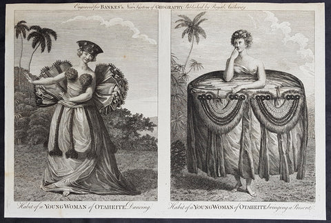
1787 Bankes Antique Print of Dancing Girls & Gifts in Tahiti During Cooks 3rd Voyage, 1777
- Title : Habit of a Young Woman of Otaheite Dancing; Habit of a Young Woman of Otaheite bringing a Present
- Size: 14in x 9in (355mm x 230mm)
- Ref #: 21526
- Date : 1787
- Condition: (A+) Fine Condition
Description:
This fine original cooper-plate engraved antique print of a view of the Island of Nomuka, a small island in the southern part of the Ha apai islands, in the Kingdom of Tonga, during Captain Cooks 3rd Voyage of discovery to the South Seas in 1777 was published in Thomas Bankes 1787 edition of A New, Royal and Authentic System of Universal Geography, Antient and Modern..... printed by Charles Cook, London.
General Definitions:
Paper thickness and quality: - Heavy and stable
Paper color : - off white
Age of map color: -
Colors used: -
General color appearance: -
Paper size: - 14in x 9in (355mm x 230mm)
Plate size: - 12in x 7 1/2in (305mm x 190mm)
Margins: - Min 1/2in (12mm)
Imperfections:
Margins: - None
Plate area: - None
Verso: - None
Background:
Nomuka is a small island in the southern part of the Ha apai group of islands in the Kingdom of Tonga. It is part of the Nomuka Group of islands, also called the Otu Muomua.
Nomuka, is 7 square kilometres in area and contains a large, brackish lake (Ano Lahi) in the middle, and also three other smaller lakes—Ano Haamea, Ano Fungalei, and Molou. There are approximately 400-500 inhabitants who subsist on fishing, farming, and remittances from family members abroad. The island has a secondary school, two primary schools, and a kindergarten. It also has seven churches.
The island is accessible by boat only. Boats leave weekly from Nukualofa and Lifuka, Haapai. There is one guesthouse on the island, and three or four small fale koloa, or convenience stores.
Notable historic visitors include Abel Tasman, Captain Cook, Captain Bligh, and William Mariner. The Dutch Abel Tasman made the first European discovery of the island on 24 January 1643. A party went ashore to get water, and the description of the huge lake they brought back afterwards leaves little doubt about the identification. Tasman called it Rotterdam island, after the city of Rotterdam, a major port in the Netherlands, and noted in his maps the indigenous name of Amamocka, a misspelling of ʻa Nomuka, ʻa being a subject indicating article. We also find the name of Amorkakij for Nomuka iki. Captain Bligh in the Bounty spent 3 days wooding and watering at Nomuka in April 1789. The Mutiny on the Bounty occurred the day after they left.
Cooks Diary.........as it was, Cook did not encounter the Tongan islands until his Second Voyage, when he stopped at both \'Eua and Tongatapu (or, by Tasman\'s nomenclature, Middleburg and Amsterdam respectively) in October of 1773. Here he was \"welcomed a shore by acclamations from an immence [sic] crowd of Men and Women not one of which had so much as a stick in their hands\".
Indeed, Cook found the islanders to be so accommodating that he returned to the archipelago in 1774 on his way back from New Zealand. Stopping at the island of Nomuka, Cook was sought out by name, and with this \"proof that these people have a communication with Amsterdam \", the cultural unity of the islands was established.
It was at this time that he famously named the island group the Friendly Archipelago, \"as a lasting friendship seems to subsist among the Inhabitants and their Courtesy to Strangers intitles [sic] them to that Name.\"
Cook\'s Third Voyage also included a visit to Tonga, this time for a stay of several months. Cook first dropped anchor at Nomuka in May, and then, at the invitation of the great chief Finau, travelled to another island, Lifuka. Here, Cook and his men were treated to such entertainments as \"whould [sic] have met with universal applause on a European Theatre.
Cook\'s Third Voyage (1776-1779)
In the course of his first two voyages, Cook circumnavigated the globe twice, sailed extensively into the Antarctic, and charted coastlines from Newfoundland to New Zealand. Following these achievements, Cook\'s third voyage was organized to seek an efficient route from England to southern and eastern Asia that would not entail rounding the Cape of Good Hope. The search for such a Northwest (or Northeast) Passage had been on the agenda of northern European mariners and merchants since the beginning of European expansion in the late fifteenth century. England\'s growing economic and colonial interests in India in the later eighteenth century provided the stimulus for the latest exploration for this route.
Cook, again in command of the Resolution, was to approach the Northwest Passage from the Pacific accompanied by a second ship, the Discovery, captained by Charles Clerke. The ships left England separately, regrouped at Cape Town, and continued on to Tasmania, New Zealand, and Tahiti. The expedition then sailed north and made landfall at Christmas Island and the Hawaiian Islands. Cook continued northward and charted the west coast of North America from Northern California as far as the Bering Strait. He returned to Hawaii for the winter and was killed in a skirmish with natives on February 14, 1779. Upon Cook\'s death, Clerke took command of the expedition but died six months later. The ships returned to England in 1780 under John Gore, who had commanded the Discovery after Cook\'s death. From start to finish, the voyage had lasted more than four years. (Ref Tooley; M&B; Clancy)
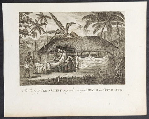
1787 Bankes Antique Print of Mummified Chief Tu of Tahiti During Cooks 3rd Voyage 1777
- Title : The Body of Tee a Chief as preserved after Death in Otaheite
- Size: 9 1/2in x 7 1/2in (240mm x 190mm)
- Ref #: 21624
- Date : 1787
- Condition: (A+) Fine Condition
Description:
This fine original cooper-plate engraved antique print of the mummified remains of the Tahitian Chief Tu visited by Captain James Cook during his 3rd Voyage of Discovery to the South Seas in 1777 was published in Thomas Bankes 1787 edition of A New, Royal and Authentic System of Universal Geography, Antient and Modern..... printed by Charles Cook, London.
General Definitions:
Paper thickness and quality: - Heavy and stable
Paper color : - off white
Age of map color: -
Colors used: -
General color appearance: -
Paper size: - 9 1/2in x 7 1/2in (240mm x 190mm)
Plate size: - 9 1/2in x 7 1/2in (240mm x 190mm)
Margins: - Min 1/2in (12mm)
Imperfections:
Margins: - None
Plate area: - None
Verso: - None
Background:
CooksThird Voyage (1776–79)
On his last voyage, Cook again commanded HMS Resolution, while Captain Charles Clerke commanded HMS Discovery. The voyage was ostensibly planned to return the Pacific Islander, Omai to Tahiti, or so the public were led to believe. The trip\\\'s principal goal was to locate a Northwest Passage around the American continent. After dropping Omai at Tahiti, Cook travelled north and in 1778 became the first European to begin formal contact with the Hawaiian Islands. After his initial landfall in January 1778 at Waimea harbour, Kauai, Cook named the archipelago the \\\"Sandwich Islands\\\" after the fourth Earl of Sandwich—the acting First Lord of the Admiralty.
From the Sandwich Islands Cook sailed north and then north-east to explore the west coast of North America north of the Spanish settlements in Alta California. He made landfall on the Oregon coast at approximately 44°30′ north latitude, naming his landing point Cape Foulweather. Bad weather forced his ships south to about 43° north before they could begin their exploration of the coast northward. He unknowingly sailed past the Strait of Juan de Fuca, and soon after entered Nootka Sound on Vancouver Island. He anchored near the First Nations village of Yuquot. Cook\\\'s two ships remained in Nootka Sound from 29 March to 26 April 1778, in what Cook called Ship Cove, now Resolution Cove, at the south end of Bligh Island, about 5 miles (8 km) east across Nootka Sound from Yuquot, lay a Nuu-chah-nulth village (whose chief Cook did not identify but may have been Maquinna). Relations between Cook\\\'s crew and the people of Yuquot were cordial if sometimes strained. In trading, the people of Yuquot demanded much more valuable items than the usual trinkets that had worked in Hawaii. Metal objects were much desired, but the lead, pewter, and tin traded at first soon fell into disrepute. The most valuable items which the British received in trade were sea otter pelts. During the stay, the Yuquot \\\"hosts\\\" essentially controlled the trade with the British vessels; the natives usually visited the British vessels at Resolution Cove instead of the British visiting the village of Yuquot at Friendly Cove.
After leaving Nootka Sound, Cook explored and mapped the coast all the way to the Bering Strait, on the way identifying what came to be known as Cook Inlet in Alaska. In a single visit, Cook charted the majority of the North American north-west coastline on world maps for the first time, determined the extent of Alaska, and closed the gaps in Russian (from the West) and Spanish (from the South) exploratory probes of the Northern limits of the Pacific.
By the second week of August 1778 Cook was through the Bering Strait, sailing into the Chukchi Sea. He headed north-east up the coast of Alaska until he was blocked by sea ice. His furthest north was 70 degrees 44 minutes. Cook then sailed west to the Siberian coast, and then south-east down the Siberian coast back to the Bering Strait. By early September 1778 he was back in the Bering Sea to begin the trip to the Sandwich (Hawaiian) Islands. He became increasingly frustrated on this voyage, and perhaps began to suffer from a stomach ailment; it has been speculated that this led to irrational behaviour towards his crew, such as forcing them to eat walrus meat, which they had pronounced inedible.
Cook returned to Hawaii in 1779. After sailing around the archipelago for some eight weeks, he made landfall at Kealakekua Bay, on \\\'Hawaii Island\\\', largest island in the Hawaiian Archipelago. Cook\\\'s arrival coincided with the Makahiki, a Hawaiian harvest festival of worship for the Polynesian god Lono. Coincidentally the form of Cook\\\'s ship, HMS Resolution, or more particularly the mast formation, sails and rigging, resembled certain significant artefacts that formed part of the season of worship. Similarly, Cook\\\'s clockwise route around the island of Hawaii before making landfall resembled the processions that took place in a clockwise direction around the island during the Lono festivals. It has been argued (most extensively by Marshall Sahlins) that such coincidences were the reasons for Cook\\\'s (and to a limited extent, his crew\\\'s) initial deification by some Hawaiians who treated Cook as an incarnation of Lono. Though this view was first suggested by members of Cook\\\'s expedition, the idea that any Hawaiians understood Cook to be Lono, and the evidence presented in support of it, were challenged in 1992.
After a month\\\'s stay, Cook attempted to resume his exploration of the Northern Pacific. Shortly after leaving Hawaii Island, however, the Resolution\\\'s foremast broke, so the ships returned to Kealakekua Bay for repairs.
Tensions rose, and a number of quarrels broke out between the Europeans and Hawaiians at Kealakekua Bay. An unknown group of Hawaiians took one of Cook\\\'s small boats. The evening when the cutter was taken, the people had become \\\"insolent\\\" even with threats to fire upon them. Cook was forced into a wild goose chase that ended with his return to the ship frustrated.[53] He attempted to kidnap and ransom the King of Hawaiʻi, Kalaniʻōpuʻu.
That following day, 14 February 1779, Cook marched through the village to retrieve the King. Cook took the King (aliʻi nui) by his own hand and led him willingly away. One of Kalaniʻōpuʻu\\\'s favorite wives, Kanekapolei and two chiefs approached the group as they were heading to boats. They pleaded with the king not to go until he stopped and sat where he stood. An old kahuna (priest), chanting rapidly while holding out a coconut, attempted to distract Cook and his men as a large crowd began to form at the shore. The king began to understand that Cook was his enemy. As Cook turned his back to help launch the boats, he was struck on the head by the villagers and then stabbed to death as he fell on his face in the surf. He was first struck on the head with a club by a chief named Kalaimanokahoʻowaha or Kanaʻina (namesake of Charles Kana\\\'ina) and then stabbed by one of the king\\\'s attendants, Nuaa. The Hawaiians carried his body away towards the back of the town, still visible to the ship through their spyglass. Four marines, Corporal James Thomas, Private Theophilus Hinks, Private Thomas Fatchett and Private John Allen, were also killed and two others were wounded in the confrontation.
The esteem which the islanders nevertheless held for Cook caused them to retain his body. Following their practice of the time, they prepared his body with funerary rituals usually reserved for the chiefs and highest elders of the society. The body was disembowelled, baked to facilitate removal of the flesh, and the bones were carefully cleaned for preservation as religious icons in a fashion somewhat reminiscent of the treatment of European saints in the Middle Ages. Some of Cook\\\'s remains, thus preserved, were eventually returned to his crew for a formal burial at sea.
Clerke assumed leadership of the expedition, and made a final attempt to pass through the Bering Strait. He died from tuberculosis on 22 August 1779 and John Gore, a veteran of Cook\\\'s first voyage, took command of Resolution and of the expedition. James King replaced Gore in command of Discovery. The expedition returned home, reaching England in October 1780. After their arrival in England, King completed Cook\\\'s account of the voyage.
David Samwell, who sailed with Cook on Resolution, wrote of him: \\\"He was a modest man, and rather bashful; of an agreeable lively conversation, sensible and intelligent. In temper he was somewhat hasty, but of a disposition the most friendly, benevolent and humane. His person was above six feet high: and, though a good looking man, he was plain both in dress and appearance. His face was full of expression: his nose extremely well shaped: his eyes which were small and of a brown cast, were quick and piercing; his eyebrows prominent, which gave his countenance altogether an air of austerity.
Tahiti previously also known as Otaheite is the largest island in the Windward group of French Polynesia. The island is located in the archipelago of the Society Islands in the central Southern Pacific Ocean.
The first European to have visited Tahiti according to existing records was lieutenant Samuel Wallis, who was circumnavigating the globe in HMS Dolphin, sighting the island on 18 June 1767, and eventually harboring in Matavai Bay. This bay was situated on the territory of the chiefdom of Pare-Arue, governed by Tu (Tu-nui-e-a\\\\\\\'a-i-te-Atua) and his regent Tutaha, and the chiefdom of Ha apape, governed by Amo and his wife Oberea (Purea). Wallis named the island King Georges Island. The first contacts were difficult, since on the 24 and 26 June 1767, Tahitian warriors in canoes showed aggression towards the British, hurling stones from their slings. In retaliation, the British sailors opened fire on the warriors in the canoes and on the hills. In reaction to this powerful counter-attack, the Tahitians laid down peace offerings for the British. Following this episode, Samuel Wallis was able to establish cordial relations with the female chieftain “Oberea “ (Purea) and remained on the island until 27 July 1767.
In July 1768, Captain James Cook was commissioned by the Royal Society and on orders from the Lords Commissioners of the Admiralty to observe the transit of Venus across the sun, a phenomenon that would be visible from Tahiti on 3 June 1769. He arrived in Tahitis Matavai Bay, commanding the HMS Endeavour on 12 April 1769. On 14 April, Cook met with Tutaha and Tepau. On 15 April, Cook picked the site for a fortified camp at Point Venus along with Banks, Parkinson, Daniel Solander, to protect Charles Greens observatory. The length of stay enabled them to undertake for the first time real ethnographic and scientific observations of the island. Assisted by the botanist Joseph Banks, and by the artist Sydney Parkinson, Cook gathered valuable information on the fauna and flora, as well as the native society, language and customs, including the proper name of the island, Otaheite. On 28 April, Cook met Purea and Tupaia, and Tupaia befriended Banks following the transit. On 21 June, Amo visited Cook, and then on 25 June, Pohuetea visited, signifying another chief seeking to ally himself with the British.
Cook and Banks circumnavigated the island from 26 June to 1 July. On the exploration, they met Ahio, chief of Ha apaiano o or Papenoo, Rita, chief of Hitia a, Pahairro, chief of Pueu, Vehiatua, chief of Tautra, Matahiapo, chief of Teahupo o, Tutea, chief of Vaira o, and Moe, chief of Afa\\\\\\\'Ahiti. In Papara, guided by Tupaia, they investigated the ruins of Mahaiatea marae, an impressive structure containing a stone pyramid or ahu, measuring 44 feet high, 267 feet long and 87 feet wide. Cook and the Endeavour departed Tahiti on 13 July 1769, taking Raiatean navigator Tupaia along for his geographic knowledge of the islands.
Cook returned to Tahiti between 15 August and 1 September 1773, greeted by the chiefs Tai and Puhi, besides the youg ari i Vehiatua II and his stepfather Ti itorea. Cook anchored in Vaitepiha Bay before returning to Point Venus where he met Tu, the paramount chief. Cook picked up two passengers from Tahiti during this trip, Porea and Ma\\\\\\\'i, with Hitihiti later replacing Porea when Cook stopped at Raiatea. Cook took Hitihiti to Tahiti on 22 April, during his return leg. Then, Cook departed Tahiti on 14 May 1774.
During his final visit, Cook returned Mai to Tahiti on 12 Aug. 1777, after Mais long visit in England. Cook also brought two Maori from Queen Charlotte Sound, Te Weherua and Koa. Cook first harbored in Vaitepiha Bay, where he visited Vehiatua II s funeral bier and the prefabricated Spanish mission house. Cook also met Vehiatua III, and inscribed on the back of the Spanish cross, Georgius tertius Rex Annis 1767, 69, 73, 74 & 77, as a counterpoint to Christus Vincit Carolus III imperat 1774 on the front. On 23 Aug., Cook sailed for Matavai Bay, where he met Tu, his father Teu, his mother Tetupaia, his brothers Ari ipaea and Vaetua, and his sisters Ari ipaea-vahine, Tetua-te-ahamai, and Auo. Cook also observed a human sacrifice, taata tapu, at the Utu-ai-mahurau marae, and 49 skulls from previous victims.
On 29 Sept. 1777, Cook sailed for Papetoai Bay on Moorea. Cook met Mahine in an act of friendship on 3 Oct., though he was an enemy of Tu. When a goat kid was stolen on 6 Oct., Cook in a rampage, ordered the burning of houses and canoes until it was returned. Cook sailed for Huahine on 11 Oct., Raiatea on 2 Nov., and Borabora on 7 Dec.
On 26 October 1788, HMS Bounty, under the command of Captain William Bligh, landed in Tahiti with the mission of carrying Tahitian breadfruit trees (Tahitian: uru) to the Caribbean. Sir Joseph Banks, the botanist from James Cooks first expedition, had concluded that this plant would be ideal to feed the African slaves working in the Caribbean plantations at very little cost. The crew remained in Tahiti for about five months, the time needed to transplant the seedlings of the trees. Three weeks after leaving Tahiti, on 28 April 1789, the crew mutinied on the initiative of Fletcher Christian. The mutineers seized the ship and set the captain and most of those members of the crew who remained loyal to him adrift in a ship\\\\\\\'s boat. A group of mutineers then went back to settle in Tahiti.
Although various explorers had refused to get involved in tribal conflicts, the mutineers from the Bounty offered their services as mercenaries and furnished arms to the family which became the Pōmare Dynasty. The chief Tū knew how to use their presence in the harbours favoured by sailors to his advantage. As a result of his alliance with the mutineers, he succeeded in considerably increasing his supremacy over the island of Tahiti.
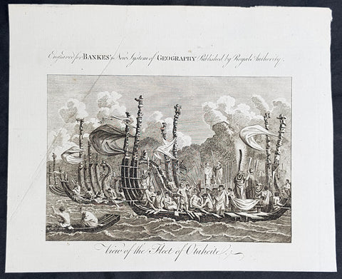
1787 Bankes Antique Print of The Tahitian Fleet - Capt Cooks 3rd Voyage in 1777
- Title : View of the Fleet of Otaheite
- Size: 9 1/2in x 7 1/2in (240mm x 190mm)
- Ref #: 21525-1
- Date : 1787
- Condition: (A+) Fine Condition
Description:
This fine original cooper-plate engraved antique print of Matavai Bay and the Island of Tahiti during Captain Cooks visit to the Island during his 3rd Voyage of Discovery to the South Seas in 1777 was published in Thomas Bankes 1787 edition of A New, Royal and Authentic System of Universal Geography, Antient and Modern..... printed by Charles Cook, London.
General Definitions:
Paper thickness and quality: - Heavy and stable
Paper color : - off white
Age of map color: -
Colors used: -
General color appearance: -
Paper size: - 9 1/2in x 7 1/2in (240mm x 190mm)
Plate size: - 9 1/2in x 7 1/2in (240mm x 190mm)
Margins: - Min 1/2in (12mm)
Imperfections:
Margins: - None
Plate area: - None
Verso: - None
Background:
CooksThird Voyage (1776–79)
On his last voyage, Cook again commanded HMS Resolution, while Captain Charles Clerke commanded HMS Discovery. The voyage was ostensibly planned to return the Pacific Islander, Omai to Tahiti, or so the public were led to believe. The trip\\\'s principal goal was to locate a Northwest Passage around the American continent. After dropping Omai at Tahiti, Cook travelled north and in 1778 became the first European to begin formal contact with the Hawaiian Islands. After his initial landfall in January 1778 at Waimea harbour, Kauai, Cook named the archipelago the \\\"Sandwich Islands\\\" after the fourth Earl of Sandwich—the acting First Lord of the Admiralty.
From the Sandwich Islands Cook sailed north and then north-east to explore the west coast of North America north of the Spanish settlements in Alta California. He made landfall on the Oregon coast at approximately 44°30′ north latitude, naming his landing point Cape Foulweather. Bad weather forced his ships south to about 43° north before they could begin their exploration of the coast northward. He unknowingly sailed past the Strait of Juan de Fuca, and soon after entered Nootka Sound on Vancouver Island. He anchored near the First Nations village of Yuquot. Cook\\\'s two ships remained in Nootka Sound from 29 March to 26 April 1778, in what Cook called Ship Cove, now Resolution Cove, at the south end of Bligh Island, about 5 miles (8 km) east across Nootka Sound from Yuquot, lay a Nuu-chah-nulth village (whose chief Cook did not identify but may have been Maquinna). Relations between Cook\\\'s crew and the people of Yuquot were cordial if sometimes strained. In trading, the people of Yuquot demanded much more valuable items than the usual trinkets that had worked in Hawaii. Metal objects were much desired, but the lead, pewter, and tin traded at first soon fell into disrepute. The most valuable items which the British received in trade were sea otter pelts. During the stay, the Yuquot \\\"hosts\\\" essentially controlled the trade with the British vessels; the natives usually visited the British vessels at Resolution Cove instead of the British visiting the village of Yuquot at Friendly Cove.
After leaving Nootka Sound, Cook explored and mapped the coast all the way to the Bering Strait, on the way identifying what came to be known as Cook Inlet in Alaska. In a single visit, Cook charted the majority of the North American north-west coastline on world maps for the first time, determined the extent of Alaska, and closed the gaps in Russian (from the West) and Spanish (from the South) exploratory probes of the Northern limits of the Pacific.
By the second week of August 1778 Cook was through the Bering Strait, sailing into the Chukchi Sea. He headed north-east up the coast of Alaska until he was blocked by sea ice. His furthest north was 70 degrees 44 minutes. Cook then sailed west to the Siberian coast, and then south-east down the Siberian coast back to the Bering Strait. By early September 1778 he was back in the Bering Sea to begin the trip to the Sandwich (Hawaiian) Islands. He became increasingly frustrated on this voyage, and perhaps began to suffer from a stomach ailment; it has been speculated that this led to irrational behaviour towards his crew, such as forcing them to eat walrus meat, which they had pronounced inedible.
Cook returned to Hawaii in 1779. After sailing around the archipelago for some eight weeks, he made landfall at Kealakekua Bay, on \\\'Hawaii Island\\\', largest island in the Hawaiian Archipelago. Cook\\\'s arrival coincided with the Makahiki, a Hawaiian harvest festival of worship for the Polynesian god Lono. Coincidentally the form of Cook\\\'s ship, HMS Resolution, or more particularly the mast formation, sails and rigging, resembled certain significant artefacts that formed part of the season of worship. Similarly, Cook\\\'s clockwise route around the island of Hawaii before making landfall resembled the processions that took place in a clockwise direction around the island during the Lono festivals. It has been argued (most extensively by Marshall Sahlins) that such coincidences were the reasons for Cook\\\'s (and to a limited extent, his crew\\\'s) initial deification by some Hawaiians who treated Cook as an incarnation of Lono. Though this view was first suggested by members of Cook\\\'s expedition, the idea that any Hawaiians understood Cook to be Lono, and the evidence presented in support of it, were challenged in 1992.
After a month\\\'s stay, Cook attempted to resume his exploration of the Northern Pacific. Shortly after leaving Hawaii Island, however, the Resolution\\\'s foremast broke, so the ships returned to Kealakekua Bay for repairs.
Tensions rose, and a number of quarrels broke out between the Europeans and Hawaiians at Kealakekua Bay. An unknown group of Hawaiians took one of Cook\\\'s small boats. The evening when the cutter was taken, the people had become \\\"insolent\\\" even with threats to fire upon them. Cook was forced into a wild goose chase that ended with his return to the ship frustrated.[53] He attempted to kidnap and ransom the King of Hawaiʻi, Kalaniʻōpuʻu.
That following day, 14 February 1779, Cook marched through the village to retrieve the King. Cook took the King (aliʻi nui) by his own hand and led him willingly away. One of Kalaniʻōpuʻu\\\'s favorite wives, Kanekapolei and two chiefs approached the group as they were heading to boats. They pleaded with the king not to go until he stopped and sat where he stood. An old kahuna (priest), chanting rapidly while holding out a coconut, attempted to distract Cook and his men as a large crowd began to form at the shore. The king began to understand that Cook was his enemy. As Cook turned his back to help launch the boats, he was struck on the head by the villagers and then stabbed to death as he fell on his face in the surf. He was first struck on the head with a club by a chief named Kalaimanokahoʻowaha or Kanaʻina (namesake of Charles Kana\\\'ina) and then stabbed by one of the king\\\'s attendants, Nuaa. The Hawaiians carried his body away towards the back of the town, still visible to the ship through their spyglass. Four marines, Corporal James Thomas, Private Theophilus Hinks, Private Thomas Fatchett and Private John Allen, were also killed and two others were wounded in the confrontation.
The esteem which the islanders nevertheless held for Cook caused them to retain his body. Following their practice of the time, they prepared his body with funerary rituals usually reserved for the chiefs and highest elders of the society. The body was disembowelled, baked to facilitate removal of the flesh, and the bones were carefully cleaned for preservation as religious icons in a fashion somewhat reminiscent of the treatment of European saints in the Middle Ages. Some of Cook\\\'s remains, thus preserved, were eventually returned to his crew for a formal burial at sea.
Clerke assumed leadership of the expedition, and made a final attempt to pass through the Bering Strait. He died from tuberculosis on 22 August 1779 and John Gore, a veteran of Cook\\\'s first voyage, took command of Resolution and of the expedition. James King replaced Gore in command of Discovery. The expedition returned home, reaching England in October 1780. After their arrival in England, King completed Cook\\\'s account of the voyage.
David Samwell, who sailed with Cook on Resolution, wrote of him: \\\"He was a modest man, and rather bashful; of an agreeable lively conversation, sensible and intelligent. In temper he was somewhat hasty, but of a disposition the most friendly, benevolent and humane. His person was above six feet high: and, though a good looking man, he was plain both in dress and appearance. His face was full of expression: his nose extremely well shaped: his eyes which were small and of a brown cast, were quick and piercing; his eyebrows prominent, which gave his countenance altogether an air of austerity.
Tahiti previously also known as Otaheite is the largest island in the Windward group of French Polynesia. The island is located in the archipelago of the Society Islands in the central Southern Pacific Ocean.
The first European to have visited Tahiti according to existing records was lieutenant Samuel Wallis, who was circumnavigating the globe in HMS Dolphin, sighting the island on 18 June 1767, and eventually harboring in Matavai Bay. This bay was situated on the territory of the chiefdom of Pare-Arue, governed by Tu (Tu-nui-e-a\\\\\\\'a-i-te-Atua) and his regent Tutaha, and the chiefdom of Ha apape, governed by Amo and his wife Oberea (Purea). Wallis named the island King Georges Island. The first contacts were difficult, since on the 24 and 26 June 1767, Tahitian warriors in canoes showed aggression towards the British, hurling stones from their slings. In retaliation, the British sailors opened fire on the warriors in the canoes and on the hills. In reaction to this powerful counter-attack, the Tahitians laid down peace offerings for the British. Following this episode, Samuel Wallis was able to establish cordial relations with the female chieftain “Oberea “ (Purea) and remained on the island until 27 July 1767.
In July 1768, Captain James Cook was commissioned by the Royal Society and on orders from the Lords Commissioners of the Admiralty to observe the transit of Venus across the sun, a phenomenon that would be visible from Tahiti on 3 June 1769. He arrived in Tahitis Matavai Bay, commanding the HMS Endeavour on 12 April 1769. On 14 April, Cook met with Tutaha and Tepau. On 15 April, Cook picked the site for a fortified camp at Point Venus along with Banks, Parkinson, Daniel Solander, to protect Charles Greens observatory. The length of stay enabled them to undertake for the first time real ethnographic and scientific observations of the island. Assisted by the botanist Joseph Banks, and by the artist Sydney Parkinson, Cook gathered valuable information on the fauna and flora, as well as the native society, language and customs, including the proper name of the island, Otaheite. On 28 April, Cook met Purea and Tupaia, and Tupaia befriended Banks following the transit. On 21 June, Amo visited Cook, and then on 25 June, Pohuetea visited, signifying another chief seeking to ally himself with the British.
Cook and Banks circumnavigated the island from 26 June to 1 July. On the exploration, they met Ahio, chief of Ha apaiano o or Papenoo, Rita, chief of Hitia a, Pahairro, chief of Pueu, Vehiatua, chief of Tautra, Matahiapo, chief of Teahupo o, Tutea, chief of Vaira o, and Moe, chief of Afa\\\\\\\'Ahiti. In Papara, guided by Tupaia, they investigated the ruins of Mahaiatea marae, an impressive structure containing a stone pyramid or ahu, measuring 44 feet high, 267 feet long and 87 feet wide. Cook and the Endeavour departed Tahiti on 13 July 1769, taking Raiatean navigator Tupaia along for his geographic knowledge of the islands.
Cook returned to Tahiti between 15 August and 1 September 1773, greeted by the chiefs Tai and Puhi, besides the youg ari i Vehiatua II and his stepfather Ti itorea. Cook anchored in Vaitepiha Bay before returning to Point Venus where he met Tu, the paramount chief. Cook picked up two passengers from Tahiti during this trip, Porea and Ma\\\\\\\'i, with Hitihiti later replacing Porea when Cook stopped at Raiatea. Cook took Hitihiti to Tahiti on 22 April, during his return leg. Then, Cook departed Tahiti on 14 May 1774.
During his final visit, Cook returned Mai to Tahiti on 12 Aug. 1777, after Mais long visit in England. Cook also brought two Maori from Queen Charlotte Sound, Te Weherua and Koa. Cook first harbored in Vaitepiha Bay, where he visited Vehiatua II s funeral bier and the prefabricated Spanish mission house. Cook also met Vehiatua III, and inscribed on the back of the Spanish cross, Georgius tertius Rex Annis 1767, 69, 73, 74 & 77, as a counterpoint to Christus Vincit Carolus III imperat 1774 on the front. On 23 Aug., Cook sailed for Matavai Bay, where he met Tu, his father Teu, his mother Tetupaia, his brothers Ari ipaea and Vaetua, and his sisters Ari ipaea-vahine, Tetua-te-ahamai, and Auo. Cook also observed a human sacrifice, taata tapu, at the Utu-ai-mahurau marae, and 49 skulls from previous victims.
On 29 Sept. 1777, Cook sailed for Papetoai Bay on Moorea. Cook met Mahine in an act of friendship on 3 Oct., though he was an enemy of Tu. When a goat kid was stolen on 6 Oct., Cook in a rampage, ordered the burning of houses and canoes until it was returned. Cook sailed for Huahine on 11 Oct., Raiatea on 2 Nov., and Borabora on 7 Dec.
On 26 October 1788, HMS Bounty, under the command of Captain William Bligh, landed in Tahiti with the mission of carrying Tahitian breadfruit trees (Tahitian: uru) to the Caribbean. Sir Joseph Banks, the botanist from James Cooks first expedition, had concluded that this plant would be ideal to feed the African slaves working in the Caribbean plantations at very little cost. The crew remained in Tahiti for about five months, the time needed to transplant the seedlings of the trees. Three weeks after leaving Tahiti, on 28 April 1789, the crew mutinied on the initiative of Fletcher Christian. The mutineers seized the ship and set the captain and most of those members of the crew who remained loyal to him adrift in a ship\\\\\\\'s boat. A group of mutineers then went back to settle in Tahiti.
Although various explorers had refused to get involved in tribal conflicts, the mutineers from the Bounty offered their services as mercenaries and furnished arms to the family which became the Pōmare Dynasty. The chief Tū knew how to use their presence in the harbours favoured by sailors to his advantage. As a result of his alliance with the mutineers, he succeeded in considerably increasing his supremacy over the island of Tahiti.
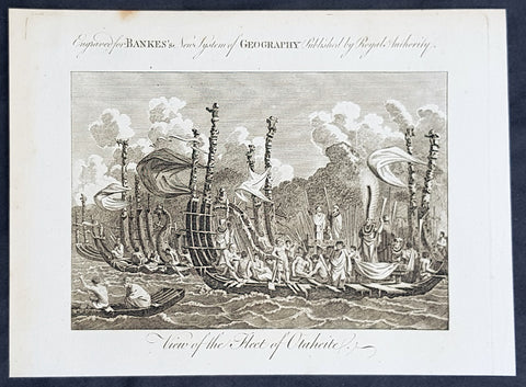
1787 Bankes Antique Print of The Tahitian Fleet - Capt Cooks 3rd Voyage in 1777
- Title : View of the Fleet of Otaheite
- Size: 9 1/2in x 7 1/2in (240mm x 190mm)
- Ref #: 40220-1
- Date : 1787
- Condition: (A+) Fine Condition
Description:
This fine original cooper-plate engraved antique print of Matavai Bay and the Island of Tahiti during Captain Cooks visit to the Island during his 3rd Voyage of Discovery to the South Seas in 1777 was published in Thomas Bankes 1787 edition of A New, Royal and Authentic System of Universal Geography, Antient and Modern..... printed by Charles Cook, London.
General Definitions:
Paper thickness and quality: - Heavy and stable
Paper color : - off white
Age of map color: -
Colors used: -
General color appearance: -
Paper size: - 9 1/2in x 7 1/2in (240mm x 190mm)
Plate size: - 9 1/2in x 7 1/2in (240mm x 190mm)
Margins: - Min 1/2in (12mm)
Imperfections:
Margins: - None
Plate area: - None
Verso: - None
Background:
CooksThird Voyage (1776–79)
On his last voyage, Cook again commanded HMS Resolution, while Captain Charles Clerke commanded HMS Discovery. The voyage was ostensibly planned to return the Pacific Islander, Omai to Tahiti, or so the public were led to believe. The trip\\\'s principal goal was to locate a Northwest Passage around the American continent. After dropping Omai at Tahiti, Cook travelled north and in 1778 became the first European to begin formal contact with the Hawaiian Islands. After his initial landfall in January 1778 at Waimea harbour, Kauai, Cook named the archipelago the \\\"Sandwich Islands\\\" after the fourth Earl of Sandwich—the acting First Lord of the Admiralty.
From the Sandwich Islands Cook sailed north and then north-east to explore the west coast of North America north of the Spanish settlements in Alta California. He made landfall on the Oregon coast at approximately 44°30′ north latitude, naming his landing point Cape Foulweather. Bad weather forced his ships south to about 43° north before they could begin their exploration of the coast northward. He unknowingly sailed past the Strait of Juan de Fuca, and soon after entered Nootka Sound on Vancouver Island. He anchored near the First Nations village of Yuquot. Cook\\\'s two ships remained in Nootka Sound from 29 March to 26 April 1778, in what Cook called Ship Cove, now Resolution Cove, at the south end of Bligh Island, about 5 miles (8 km) east across Nootka Sound from Yuquot, lay a Nuu-chah-nulth village (whose chief Cook did not identify but may have been Maquinna). Relations between Cook\\\'s crew and the people of Yuquot were cordial if sometimes strained. In trading, the people of Yuquot demanded much more valuable items than the usual trinkets that had worked in Hawaii. Metal objects were much desired, but the lead, pewter, and tin traded at first soon fell into disrepute. The most valuable items which the British received in trade were sea otter pelts. During the stay, the Yuquot \\\"hosts\\\" essentially controlled the trade with the British vessels; the natives usually visited the British vessels at Resolution Cove instead of the British visiting the village of Yuquot at Friendly Cove.
After leaving Nootka Sound, Cook explored and mapped the coast all the way to the Bering Strait, on the way identifying what came to be known as Cook Inlet in Alaska. In a single visit, Cook charted the majority of the North American north-west coastline on world maps for the first time, determined the extent of Alaska, and closed the gaps in Russian (from the West) and Spanish (from the South) exploratory probes of the Northern limits of the Pacific.
By the second week of August 1778 Cook was through the Bering Strait, sailing into the Chukchi Sea. He headed north-east up the coast of Alaska until he was blocked by sea ice. His furthest north was 70 degrees 44 minutes. Cook then sailed west to the Siberian coast, and then south-east down the Siberian coast back to the Bering Strait. By early September 1778 he was back in the Bering Sea to begin the trip to the Sandwich (Hawaiian) Islands. He became increasingly frustrated on this voyage, and perhaps began to suffer from a stomach ailment; it has been speculated that this led to irrational behaviour towards his crew, such as forcing them to eat walrus meat, which they had pronounced inedible.
Cook returned to Hawaii in 1779. After sailing around the archipelago for some eight weeks, he made landfall at Kealakekua Bay, on \\\'Hawaii Island\\\', largest island in the Hawaiian Archipelago. Cook\\\'s arrival coincided with the Makahiki, a Hawaiian harvest festival of worship for the Polynesian god Lono. Coincidentally the form of Cook\\\'s ship, HMS Resolution, or more particularly the mast formation, sails and rigging, resembled certain significant artefacts that formed part of the season of worship. Similarly, Cook\\\'s clockwise route around the island of Hawaii before making landfall resembled the processions that took place in a clockwise direction around the island during the Lono festivals. It has been argued (most extensively by Marshall Sahlins) that such coincidences were the reasons for Cook\\\'s (and to a limited extent, his crew\\\'s) initial deification by some Hawaiians who treated Cook as an incarnation of Lono. Though this view was first suggested by members of Cook\\\'s expedition, the idea that any Hawaiians understood Cook to be Lono, and the evidence presented in support of it, were challenged in 1992.
After a month\\\'s stay, Cook attempted to resume his exploration of the Northern Pacific. Shortly after leaving Hawaii Island, however, the Resolution\\\'s foremast broke, so the ships returned to Kealakekua Bay for repairs.
Tensions rose, and a number of quarrels broke out between the Europeans and Hawaiians at Kealakekua Bay. An unknown group of Hawaiians took one of Cook\\\'s small boats. The evening when the cutter was taken, the people had become \\\"insolent\\\" even with threats to fire upon them. Cook was forced into a wild goose chase that ended with his return to the ship frustrated.[53] He attempted to kidnap and ransom the King of Hawaiʻi, Kalaniʻōpuʻu.
That following day, 14 February 1779, Cook marched through the village to retrieve the King. Cook took the King (aliʻi nui) by his own hand and led him willingly away. One of Kalaniʻōpuʻu\\\'s favorite wives, Kanekapolei and two chiefs approached the group as they were heading to boats. They pleaded with the king not to go until he stopped and sat where he stood. An old kahuna (priest), chanting rapidly while holding out a coconut, attempted to distract Cook and his men as a large crowd began to form at the shore. The king began to understand that Cook was his enemy. As Cook turned his back to help launch the boats, he was struck on the head by the villagers and then stabbed to death as he fell on his face in the surf. He was first struck on the head with a club by a chief named Kalaimanokahoʻowaha or Kanaʻina (namesake of Charles Kana\\\'ina) and then stabbed by one of the king\\\'s attendants, Nuaa. The Hawaiians carried his body away towards the back of the town, still visible to the ship through their spyglass. Four marines, Corporal James Thomas, Private Theophilus Hinks, Private Thomas Fatchett and Private John Allen, were also killed and two others were wounded in the confrontation.
The esteem which the islanders nevertheless held for Cook caused them to retain his body. Following their practice of the time, they prepared his body with funerary rituals usually reserved for the chiefs and highest elders of the society. The body was disembowelled, baked to facilitate removal of the flesh, and the bones were carefully cleaned for preservation as religious icons in a fashion somewhat reminiscent of the treatment of European saints in the Middle Ages. Some of Cook\\\'s remains, thus preserved, were eventually returned to his crew for a formal burial at sea.
Clerke assumed leadership of the expedition, and made a final attempt to pass through the Bering Strait. He died from tuberculosis on 22 August 1779 and John Gore, a veteran of Cook\\\'s first voyage, took command of Resolution and of the expedition. James King replaced Gore in command of Discovery. The expedition returned home, reaching England in October 1780. After their arrival in England, King completed Cook\\\'s account of the voyage.
David Samwell, who sailed with Cook on Resolution, wrote of him: \\\"He was a modest man, and rather bashful; of an agreeable lively conversation, sensible and intelligent. In temper he was somewhat hasty, but of a disposition the most friendly, benevolent and humane. His person was above six feet high: and, though a good looking man, he was plain both in dress and appearance. His face was full of expression: his nose extremely well shaped: his eyes which were small and of a brown cast, were quick and piercing; his eyebrows prominent, which gave his countenance altogether an air of austerity.
Tahiti previously also known as Otaheite is the largest island in the Windward group of French Polynesia. The island is located in the archipelago of the Society Islands in the central Southern Pacific Ocean.
The first European to have visited Tahiti according to existing records was lieutenant Samuel Wallis, who was circumnavigating the globe in HMS Dolphin, sighting the island on 18 June 1767, and eventually harboring in Matavai Bay. This bay was situated on the territory of the chiefdom of Pare-Arue, governed by Tu (Tu-nui-e-a\\\\\\\'a-i-te-Atua) and his regent Tutaha, and the chiefdom of Ha apape, governed by Amo and his wife Oberea (Purea). Wallis named the island King Georges Island. The first contacts were difficult, since on the 24 and 26 June 1767, Tahitian warriors in canoes showed aggression towards the British, hurling stones from their slings. In retaliation, the British sailors opened fire on the warriors in the canoes and on the hills. In reaction to this powerful counter-attack, the Tahitians laid down peace offerings for the British. Following this episode, Samuel Wallis was able to establish cordial relations with the female chieftain “Oberea “ (Purea) and remained on the island until 27 July 1767.
In July 1768, Captain James Cook was commissioned by the Royal Society and on orders from the Lords Commissioners of the Admiralty to observe the transit of Venus across the sun, a phenomenon that would be visible from Tahiti on 3 June 1769. He arrived in Tahitis Matavai Bay, commanding the HMS Endeavour on 12 April 1769. On 14 April, Cook met with Tutaha and Tepau. On 15 April, Cook picked the site for a fortified camp at Point Venus along with Banks, Parkinson, Daniel Solander, to protect Charles Greens observatory. The length of stay enabled them to undertake for the first time real ethnographic and scientific observations of the island. Assisted by the botanist Joseph Banks, and by the artist Sydney Parkinson, Cook gathered valuable information on the fauna and flora, as well as the native society, language and customs, including the proper name of the island, Otaheite. On 28 April, Cook met Purea and Tupaia, and Tupaia befriended Banks following the transit. On 21 June, Amo visited Cook, and then on 25 June, Pohuetea visited, signifying another chief seeking to ally himself with the British.
Cook and Banks circumnavigated the island from 26 June to 1 July. On the exploration, they met Ahio, chief of Ha apaiano o or Papenoo, Rita, chief of Hitia a, Pahairro, chief of Pueu, Vehiatua, chief of Tautra, Matahiapo, chief of Teahupo o, Tutea, chief of Vaira o, and Moe, chief of Afa\\\\\\\'Ahiti. In Papara, guided by Tupaia, they investigated the ruins of Mahaiatea marae, an impressive structure containing a stone pyramid or ahu, measuring 44 feet high, 267 feet long and 87 feet wide. Cook and the Endeavour departed Tahiti on 13 July 1769, taking Raiatean navigator Tupaia along for his geographic knowledge of the islands.
Cook returned to Tahiti between 15 August and 1 September 1773, greeted by the chiefs Tai and Puhi, besides the youg ari i Vehiatua II and his stepfather Ti itorea. Cook anchored in Vaitepiha Bay before returning to Point Venus where he met Tu, the paramount chief. Cook picked up two passengers from Tahiti during this trip, Porea and Ma\\\\\\\'i, with Hitihiti later replacing Porea when Cook stopped at Raiatea. Cook took Hitihiti to Tahiti on 22 April, during his return leg. Then, Cook departed Tahiti on 14 May 1774.
During his final visit, Cook returned Mai to Tahiti on 12 Aug. 1777, after Mais long visit in England. Cook also brought two Maori from Queen Charlotte Sound, Te Weherua and Koa. Cook first harbored in Vaitepiha Bay, where he visited Vehiatua II s funeral bier and the prefabricated Spanish mission house. Cook also met Vehiatua III, and inscribed on the back of the Spanish cross, Georgius tertius Rex Annis 1767, 69, 73, 74 & 77, as a counterpoint to Christus Vincit Carolus III imperat 1774 on the front. On 23 Aug., Cook sailed for Matavai Bay, where he met Tu, his father Teu, his mother Tetupaia, his brothers Ari ipaea and Vaetua, and his sisters Ari ipaea-vahine, Tetua-te-ahamai, and Auo. Cook also observed a human sacrifice, taata tapu, at the Utu-ai-mahurau marae, and 49 skulls from previous victims.
On 29 Sept. 1777, Cook sailed for Papetoai Bay on Moorea. Cook met Mahine in an act of friendship on 3 Oct., though he was an enemy of Tu. When a goat kid was stolen on 6 Oct., Cook in a rampage, ordered the burning of houses and canoes until it was returned. Cook sailed for Huahine on 11 Oct., Raiatea on 2 Nov., and Borabora on 7 Dec.
On 26 October 1788, HMS Bounty, under the command of Captain William Bligh, landed in Tahiti with the mission of carrying Tahitian breadfruit trees (Tahitian: uru) to the Caribbean. Sir Joseph Banks, the botanist from James Cooks first expedition, had concluded that this plant would be ideal to feed the African slaves working in the Caribbean plantations at very little cost. The crew remained in Tahiti for about five months, the time needed to transplant the seedlings of the trees. Three weeks after leaving Tahiti, on 28 April 1789, the crew mutinied on the initiative of Fletcher Christian. The mutineers seized the ship and set the captain and most of those members of the crew who remained loyal to him adrift in a ship\\\\\\\'s boat. A group of mutineers then went back to settle in Tahiti.
Although various explorers had refused to get involved in tribal conflicts, the mutineers from the Bounty offered their services as mercenaries and furnished arms to the family which became the Pōmare Dynasty. The chief Tū knew how to use their presence in the harbours favoured by sailors to his advantage. As a result of his alliance with the mutineers, he succeeded in considerably increasing his supremacy over the island of Tahiti.
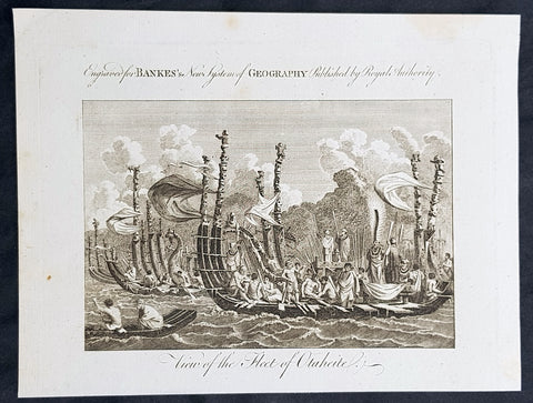
1787 Bankes Antique Print of The Tahitian Fleet - Capt Cooks 3rd Voyage in 1777
- Title : View of the Fleet of Otaheite
- Size: 9 1/2in x 7 1/2in (240mm x 190mm)
- Ref #: 31793-1
- Date : 1787
- Condition: (A+) Fine Condition
Description:
This fine original cooper-plate engraved antique print of Matavai Bay and the Island of Tahiti during Captain Cooks visit to the Island during his 3rd Voyage of Discovery to the South Seas in 1777 was published in Thomas Bankes 1787 edition of A New, Royal and Authentic System of Universal Geography, Antient and Modern..... printed by Charles Cook, London.
General Definitions:
Paper thickness and quality: - Heavy and stable
Paper color : - off white
Age of map color: -
Colors used: -
General color appearance: -
Paper size: - 9 1/2in x 7 1/2in (240mm x 190mm)
Plate size: - 9 1/2in x 7 1/2in (240mm x 190mm)
Margins: - Min 1/2in (12mm)
Imperfections:
Margins: - None
Plate area: - None
Verso: - None
Background:
CooksThird Voyage (1776–79)
On his last voyage, Cook again commanded HMS Resolution, while Captain Charles Clerke commanded HMS Discovery. The voyage was ostensibly planned to return the Pacific Islander, Omai to Tahiti, or so the public were led to believe. The trip\\\'s principal goal was to locate a Northwest Passage around the American continent. After dropping Omai at Tahiti, Cook travelled north and in 1778 became the first European to begin formal contact with the Hawaiian Islands. After his initial landfall in January 1778 at Waimea harbour, Kauai, Cook named the archipelago the \\\"Sandwich Islands\\\" after the fourth Earl of Sandwich—the acting First Lord of the Admiralty.
From the Sandwich Islands Cook sailed north and then north-east to explore the west coast of North America north of the Spanish settlements in Alta California. He made landfall on the Oregon coast at approximately 44°30′ north latitude, naming his landing point Cape Foulweather. Bad weather forced his ships south to about 43° north before they could begin their exploration of the coast northward. He unknowingly sailed past the Strait of Juan de Fuca, and soon after entered Nootka Sound on Vancouver Island. He anchored near the First Nations village of Yuquot. Cook\\\'s two ships remained in Nootka Sound from 29 March to 26 April 1778, in what Cook called Ship Cove, now Resolution Cove, at the south end of Bligh Island, about 5 miles (8 km) east across Nootka Sound from Yuquot, lay a Nuu-chah-nulth village (whose chief Cook did not identify but may have been Maquinna). Relations between Cook\\\'s crew and the people of Yuquot were cordial if sometimes strained. In trading, the people of Yuquot demanded much more valuable items than the usual trinkets that had worked in Hawaii. Metal objects were much desired, but the lead, pewter, and tin traded at first soon fell into disrepute. The most valuable items which the British received in trade were sea otter pelts. During the stay, the Yuquot \\\"hosts\\\" essentially controlled the trade with the British vessels; the natives usually visited the British vessels at Resolution Cove instead of the British visiting the village of Yuquot at Friendly Cove.
After leaving Nootka Sound, Cook explored and mapped the coast all the way to the Bering Strait, on the way identifying what came to be known as Cook Inlet in Alaska. In a single visit, Cook charted the majority of the North American north-west coastline on world maps for the first time, determined the extent of Alaska, and closed the gaps in Russian (from the West) and Spanish (from the South) exploratory probes of the Northern limits of the Pacific.
By the second week of August 1778 Cook was through the Bering Strait, sailing into the Chukchi Sea. He headed north-east up the coast of Alaska until he was blocked by sea ice. His furthest north was 70 degrees 44 minutes. Cook then sailed west to the Siberian coast, and then south-east down the Siberian coast back to the Bering Strait. By early September 1778 he was back in the Bering Sea to begin the trip to the Sandwich (Hawaiian) Islands. He became increasingly frustrated on this voyage, and perhaps began to suffer from a stomach ailment; it has been speculated that this led to irrational behaviour towards his crew, such as forcing them to eat walrus meat, which they had pronounced inedible.
Cook returned to Hawaii in 1779. After sailing around the archipelago for some eight weeks, he made landfall at Kealakekua Bay, on \\\'Hawaii Island\\\', largest island in the Hawaiian Archipelago. Cook\\\'s arrival coincided with the Makahiki, a Hawaiian harvest festival of worship for the Polynesian god Lono. Coincidentally the form of Cook\\\'s ship, HMS Resolution, or more particularly the mast formation, sails and rigging, resembled certain significant artefacts that formed part of the season of worship. Similarly, Cook\\\'s clockwise route around the island of Hawaii before making landfall resembled the processions that took place in a clockwise direction around the island during the Lono festivals. It has been argued (most extensively by Marshall Sahlins) that such coincidences were the reasons for Cook\\\'s (and to a limited extent, his crew\\\'s) initial deification by some Hawaiians who treated Cook as an incarnation of Lono. Though this view was first suggested by members of Cook\\\'s expedition, the idea that any Hawaiians understood Cook to be Lono, and the evidence presented in support of it, were challenged in 1992.
After a month\\\'s stay, Cook attempted to resume his exploration of the Northern Pacific. Shortly after leaving Hawaii Island, however, the Resolution\\\'s foremast broke, so the ships returned to Kealakekua Bay for repairs.
Tensions rose, and a number of quarrels broke out between the Europeans and Hawaiians at Kealakekua Bay. An unknown group of Hawaiians took one of Cook\\\'s small boats. The evening when the cutter was taken, the people had become \\\"insolent\\\" even with threats to fire upon them. Cook was forced into a wild goose chase that ended with his return to the ship frustrated.[53] He attempted to kidnap and ransom the King of Hawaiʻi, Kalaniʻōpuʻu.
That following day, 14 February 1779, Cook marched through the village to retrieve the King. Cook took the King (aliʻi nui) by his own hand and led him willingly away. One of Kalaniʻōpuʻu\\\'s favorite wives, Kanekapolei and two chiefs approached the group as they were heading to boats. They pleaded with the king not to go until he stopped and sat where he stood. An old kahuna (priest), chanting rapidly while holding out a coconut, attempted to distract Cook and his men as a large crowd began to form at the shore. The king began to understand that Cook was his enemy. As Cook turned his back to help launch the boats, he was struck on the head by the villagers and then stabbed to death as he fell on his face in the surf. He was first struck on the head with a club by a chief named Kalaimanokahoʻowaha or Kanaʻina (namesake of Charles Kana\\\'ina) and then stabbed by one of the king\\\'s attendants, Nuaa. The Hawaiians carried his body away towards the back of the town, still visible to the ship through their spyglass. Four marines, Corporal James Thomas, Private Theophilus Hinks, Private Thomas Fatchett and Private John Allen, were also killed and two others were wounded in the confrontation.
The esteem which the islanders nevertheless held for Cook caused them to retain his body. Following their practice of the time, they prepared his body with funerary rituals usually reserved for the chiefs and highest elders of the society. The body was disembowelled, baked to facilitate removal of the flesh, and the bones were carefully cleaned for preservation as religious icons in a fashion somewhat reminiscent of the treatment of European saints in the Middle Ages. Some of Cook\\\'s remains, thus preserved, were eventually returned to his crew for a formal burial at sea.
Clerke assumed leadership of the expedition, and made a final attempt to pass through the Bering Strait. He died from tuberculosis on 22 August 1779 and John Gore, a veteran of Cook\\\'s first voyage, took command of Resolution and of the expedition. James King replaced Gore in command of Discovery. The expedition returned home, reaching England in October 1780. After their arrival in England, King completed Cook\\\'s account of the voyage.
David Samwell, who sailed with Cook on Resolution, wrote of him: \\\"He was a modest man, and rather bashful; of an agreeable lively conversation, sensible and intelligent. In temper he was somewhat hasty, but of a disposition the most friendly, benevolent and humane. His person was above six feet high: and, though a good looking man, he was plain both in dress and appearance. His face was full of expression: his nose extremely well shaped: his eyes which were small and of a brown cast, were quick and piercing; his eyebrows prominent, which gave his countenance altogether an air of austerity.
Tahiti previously also known as Otaheite is the largest island in the Windward group of French Polynesia. The island is located in the archipelago of the Society Islands in the central Southern Pacific Ocean.
The first European to have visited Tahiti according to existing records was lieutenant Samuel Wallis, who was circumnavigating the globe in HMS Dolphin, sighting the island on 18 June 1767, and eventually harboring in Matavai Bay. This bay was situated on the territory of the chiefdom of Pare-Arue, governed by Tu (Tu-nui-e-a\\\\\\\'a-i-te-Atua) and his regent Tutaha, and the chiefdom of Ha apape, governed by Amo and his wife Oberea (Purea). Wallis named the island King Georges Island. The first contacts were difficult, since on the 24 and 26 June 1767, Tahitian warriors in canoes showed aggression towards the British, hurling stones from their slings. In retaliation, the British sailors opened fire on the warriors in the canoes and on the hills. In reaction to this powerful counter-attack, the Tahitians laid down peace offerings for the British. Following this episode, Samuel Wallis was able to establish cordial relations with the female chieftain “Oberea “ (Purea) and remained on the island until 27 July 1767.
In July 1768, Captain James Cook was commissioned by the Royal Society and on orders from the Lords Commissioners of the Admiralty to observe the transit of Venus across the sun, a phenomenon that would be visible from Tahiti on 3 June 1769. He arrived in Tahitis Matavai Bay, commanding the HMS Endeavour on 12 April 1769. On 14 April, Cook met with Tutaha and Tepau. On 15 April, Cook picked the site for a fortified camp at Point Venus along with Banks, Parkinson, Daniel Solander, to protect Charles Greens observatory. The length of stay enabled them to undertake for the first time real ethnographic and scientific observations of the island. Assisted by the botanist Joseph Banks, and by the artist Sydney Parkinson, Cook gathered valuable information on the fauna and flora, as well as the native society, language and customs, including the proper name of the island, Otaheite. On 28 April, Cook met Purea and Tupaia, and Tupaia befriended Banks following the transit. On 21 June, Amo visited Cook, and then on 25 June, Pohuetea visited, signifying another chief seeking to ally himself with the British.
Cook and Banks circumnavigated the island from 26 June to 1 July. On the exploration, they met Ahio, chief of Ha apaiano o or Papenoo, Rita, chief of Hitia a, Pahairro, chief of Pueu, Vehiatua, chief of Tautra, Matahiapo, chief of Teahupo o, Tutea, chief of Vaira o, and Moe, chief of Afa\\\\\\\'Ahiti. In Papara, guided by Tupaia, they investigated the ruins of Mahaiatea marae, an impressive structure containing a stone pyramid or ahu, measuring 44 feet high, 267 feet long and 87 feet wide. Cook and the Endeavour departed Tahiti on 13 July 1769, taking Raiatean navigator Tupaia along for his geographic knowledge of the islands.
Cook returned to Tahiti between 15 August and 1 September 1773, greeted by the chiefs Tai and Puhi, besides the youg ari i Vehiatua II and his stepfather Ti itorea. Cook anchored in Vaitepiha Bay before returning to Point Venus where he met Tu, the paramount chief. Cook picked up two passengers from Tahiti during this trip, Porea and Ma\\\\\\\'i, with Hitihiti later replacing Porea when Cook stopped at Raiatea. Cook took Hitihiti to Tahiti on 22 April, during his return leg. Then, Cook departed Tahiti on 14 May 1774.
During his final visit, Cook returned Mai to Tahiti on 12 Aug. 1777, after Mais long visit in England. Cook also brought two Maori from Queen Charlotte Sound, Te Weherua and Koa. Cook first harbored in Vaitepiha Bay, where he visited Vehiatua II s funeral bier and the prefabricated Spanish mission house. Cook also met Vehiatua III, and inscribed on the back of the Spanish cross, Georgius tertius Rex Annis 1767, 69, 73, 74 & 77, as a counterpoint to Christus Vincit Carolus III imperat 1774 on the front. On 23 Aug., Cook sailed for Matavai Bay, where he met Tu, his father Teu, his mother Tetupaia, his brothers Ari ipaea and Vaetua, and his sisters Ari ipaea-vahine, Tetua-te-ahamai, and Auo. Cook also observed a human sacrifice, taata tapu, at the Utu-ai-mahurau marae, and 49 skulls from previous victims.
On 29 Sept. 1777, Cook sailed for Papetoai Bay on Moorea. Cook met Mahine in an act of friendship on 3 Oct., though he was an enemy of Tu. When a goat kid was stolen on 6 Oct., Cook in a rampage, ordered the burning of houses and canoes until it was returned. Cook sailed for Huahine on 11 Oct., Raiatea on 2 Nov., and Borabora on 7 Dec.
On 26 October 1788, HMS Bounty, under the command of Captain William Bligh, landed in Tahiti with the mission of carrying Tahitian breadfruit trees (Tahitian: uru) to the Caribbean. Sir Joseph Banks, the botanist from James Cooks first expedition, had concluded that this plant would be ideal to feed the African slaves working in the Caribbean plantations at very little cost. The crew remained in Tahiti for about five months, the time needed to transplant the seedlings of the trees. Three weeks after leaving Tahiti, on 28 April 1789, the crew mutinied on the initiative of Fletcher Christian. The mutineers seized the ship and set the captain and most of those members of the crew who remained loyal to him adrift in a ship\\\\\\\'s boat. A group of mutineers then went back to settle in Tahiti.
Although various explorers had refused to get involved in tribal conflicts, the mutineers from the Bounty offered their services as mercenaries and furnished arms to the family which became the Pōmare Dynasty. The chief Tū knew how to use their presence in the harbours favoured by sailors to his advantage. As a result of his alliance with the mutineers, he succeeded in considerably increasing his supremacy over the island of Tahiti.
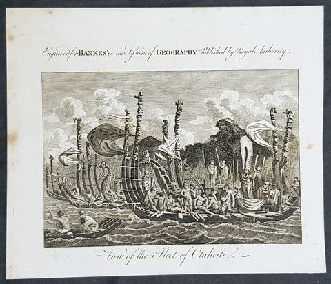
1787 Bankes Antique Print of The Tahitian Fleet - Capt Cooks 3rd Voyage in 1777
- Title : View of the Fleet of Otaheite
- Size: 9 1/2in x 7 1/2in (240mm x 190mm)
- Ref #: 21658-1
- Date : 1787
- Condition: (A+) Fine Condition
Description:
This fine original cooper-plate engraved antique print of Matavai Bay and the Island of Tahiti during Captain Cooks visit to the Island during his 3rd Voyage of Discovery to the South Seas in 1777 was published in Thomas Bankes 1787 edition of A New, Royal and Authentic System of Universal Geography, Antient and Modern..... printed by Charles Cook, London.
General Definitions:
Paper thickness and quality: - Heavy and stable
Paper color : - off white
Age of map color: -
Colors used: -
General color appearance: -
Paper size: - 9 1/2in x 7 1/2in (240mm x 190mm)
Plate size: - 9 1/2in x 7 1/2in (240mm x 190mm)
Margins: - Min 1/2in (12mm)
Imperfections:
Margins: - None
Plate area: - None
Verso: - None
Background:
CooksThird Voyage (1776–79)
On his last voyage, Cook again commanded HMS Resolution, while Captain Charles Clerke commanded HMS Discovery. The voyage was ostensibly planned to return the Pacific Islander, Omai to Tahiti, or so the public were led to believe. The trip\\\'s principal goal was to locate a Northwest Passage around the American continent. After dropping Omai at Tahiti, Cook travelled north and in 1778 became the first European to begin formal contact with the Hawaiian Islands. After his initial landfall in January 1778 at Waimea harbour, Kauai, Cook named the archipelago the \\\"Sandwich Islands\\\" after the fourth Earl of Sandwich—the acting First Lord of the Admiralty.
From the Sandwich Islands Cook sailed north and then north-east to explore the west coast of North America north of the Spanish settlements in Alta California. He made landfall on the Oregon coast at approximately 44°30′ north latitude, naming his landing point Cape Foulweather. Bad weather forced his ships south to about 43° north before they could begin their exploration of the coast northward. He unknowingly sailed past the Strait of Juan de Fuca, and soon after entered Nootka Sound on Vancouver Island. He anchored near the First Nations village of Yuquot. Cook\\\'s two ships remained in Nootka Sound from 29 March to 26 April 1778, in what Cook called Ship Cove, now Resolution Cove, at the south end of Bligh Island, about 5 miles (8 km) east across Nootka Sound from Yuquot, lay a Nuu-chah-nulth village (whose chief Cook did not identify but may have been Maquinna). Relations between Cook\\\'s crew and the people of Yuquot were cordial if sometimes strained. In trading, the people of Yuquot demanded much more valuable items than the usual trinkets that had worked in Hawaii. Metal objects were much desired, but the lead, pewter, and tin traded at first soon fell into disrepute. The most valuable items which the British received in trade were sea otter pelts. During the stay, the Yuquot \\\"hosts\\\" essentially controlled the trade with the British vessels; the natives usually visited the British vessels at Resolution Cove instead of the British visiting the village of Yuquot at Friendly Cove.
After leaving Nootka Sound, Cook explored and mapped the coast all the way to the Bering Strait, on the way identifying what came to be known as Cook Inlet in Alaska. In a single visit, Cook charted the majority of the North American north-west coastline on world maps for the first time, determined the extent of Alaska, and closed the gaps in Russian (from the West) and Spanish (from the South) exploratory probes of the Northern limits of the Pacific.
By the second week of August 1778 Cook was through the Bering Strait, sailing into the Chukchi Sea. He headed north-east up the coast of Alaska until he was blocked by sea ice. His furthest north was 70 degrees 44 minutes. Cook then sailed west to the Siberian coast, and then south-east down the Siberian coast back to the Bering Strait. By early September 1778 he was back in the Bering Sea to begin the trip to the Sandwich (Hawaiian) Islands. He became increasingly frustrated on this voyage, and perhaps began to suffer from a stomach ailment; it has been speculated that this led to irrational behaviour towards his crew, such as forcing them to eat walrus meat, which they had pronounced inedible.
Cook returned to Hawaii in 1779. After sailing around the archipelago for some eight weeks, he made landfall at Kealakekua Bay, on \\\'Hawaii Island\\\', largest island in the Hawaiian Archipelago. Cook\\\'s arrival coincided with the Makahiki, a Hawaiian harvest festival of worship for the Polynesian god Lono. Coincidentally the form of Cook\\\'s ship, HMS Resolution, or more particularly the mast formation, sails and rigging, resembled certain significant artefacts that formed part of the season of worship. Similarly, Cook\\\'s clockwise route around the island of Hawaii before making landfall resembled the processions that took place in a clockwise direction around the island during the Lono festivals. It has been argued (most extensively by Marshall Sahlins) that such coincidences were the reasons for Cook\\\'s (and to a limited extent, his crew\\\'s) initial deification by some Hawaiians who treated Cook as an incarnation of Lono. Though this view was first suggested by members of Cook\\\'s expedition, the idea that any Hawaiians understood Cook to be Lono, and the evidence presented in support of it, were challenged in 1992.
After a month\\\'s stay, Cook attempted to resume his exploration of the Northern Pacific. Shortly after leaving Hawaii Island, however, the Resolution\\\'s foremast broke, so the ships returned to Kealakekua Bay for repairs.
Tensions rose, and a number of quarrels broke out between the Europeans and Hawaiians at Kealakekua Bay. An unknown group of Hawaiians took one of Cook\\\'s small boats. The evening when the cutter was taken, the people had become \\\"insolent\\\" even with threats to fire upon them. Cook was forced into a wild goose chase that ended with his return to the ship frustrated.[53] He attempted to kidnap and ransom the King of Hawaiʻi, Kalaniʻōpuʻu.
That following day, 14 February 1779, Cook marched through the village to retrieve the King. Cook took the King (aliʻi nui) by his own hand and led him willingly away. One of Kalaniʻōpuʻu\\\'s favorite wives, Kanekapolei and two chiefs approached the group as they were heading to boats. They pleaded with the king not to go until he stopped and sat where he stood. An old kahuna (priest), chanting rapidly while holding out a coconut, attempted to distract Cook and his men as a large crowd began to form at the shore. The king began to understand that Cook was his enemy. As Cook turned his back to help launch the boats, he was struck on the head by the villagers and then stabbed to death as he fell on his face in the surf. He was first struck on the head with a club by a chief named Kalaimanokahoʻowaha or Kanaʻina (namesake of Charles Kana\\\'ina) and then stabbed by one of the king\\\'s attendants, Nuaa. The Hawaiians carried his body away towards the back of the town, still visible to the ship through their spyglass. Four marines, Corporal James Thomas, Private Theophilus Hinks, Private Thomas Fatchett and Private John Allen, were also killed and two others were wounded in the confrontation.
The esteem which the islanders nevertheless held for Cook caused them to retain his body. Following their practice of the time, they prepared his body with funerary rituals usually reserved for the chiefs and highest elders of the society. The body was disembowelled, baked to facilitate removal of the flesh, and the bones were carefully cleaned for preservation as religious icons in a fashion somewhat reminiscent of the treatment of European saints in the Middle Ages. Some of Cook\\\'s remains, thus preserved, were eventually returned to his crew for a formal burial at sea.
Clerke assumed leadership of the expedition, and made a final attempt to pass through the Bering Strait. He died from tuberculosis on 22 August 1779 and John Gore, a veteran of Cook\\\'s first voyage, took command of Resolution and of the expedition. James King replaced Gore in command of Discovery. The expedition returned home, reaching England in October 1780. After their arrival in England, King completed Cook\\\'s account of the voyage.
David Samwell, who sailed with Cook on Resolution, wrote of him: \\\"He was a modest man, and rather bashful; of an agreeable lively conversation, sensible and intelligent. In temper he was somewhat hasty, but of a disposition the most friendly, benevolent and humane. His person was above six feet high: and, though a good looking man, he was plain both in dress and appearance. His face was full of expression: his nose extremely well shaped: his eyes which were small and of a brown cast, were quick and piercing; his eyebrows prominent, which gave his countenance altogether an air of austerity.
Tahiti previously also known as Otaheite is the largest island in the Windward group of French Polynesia. The island is located in the archipelago of the Society Islands in the central Southern Pacific Ocean.
The first European to have visited Tahiti according to existing records was lieutenant Samuel Wallis, who was circumnavigating the globe in HMS Dolphin, sighting the island on 18 June 1767, and eventually harboring in Matavai Bay. This bay was situated on the territory of the chiefdom of Pare-Arue, governed by Tu (Tu-nui-e-a\\\\\\\'a-i-te-Atua) and his regent Tutaha, and the chiefdom of Ha apape, governed by Amo and his wife Oberea (Purea). Wallis named the island King Georges Island. The first contacts were difficult, since on the 24 and 26 June 1767, Tahitian warriors in canoes showed aggression towards the British, hurling stones from their slings. In retaliation, the British sailors opened fire on the warriors in the canoes and on the hills. In reaction to this powerful counter-attack, the Tahitians laid down peace offerings for the British. Following this episode, Samuel Wallis was able to establish cordial relations with the female chieftain “Oberea “ (Purea) and remained on the island until 27 July 1767.
In July 1768, Captain James Cook was commissioned by the Royal Society and on orders from the Lords Commissioners of the Admiralty to observe the transit of Venus across the sun, a phenomenon that would be visible from Tahiti on 3 June 1769. He arrived in Tahitis Matavai Bay, commanding the HMS Endeavour on 12 April 1769. On 14 April, Cook met with Tutaha and Tepau. On 15 April, Cook picked the site for a fortified camp at Point Venus along with Banks, Parkinson, Daniel Solander, to protect Charles Greens observatory. The length of stay enabled them to undertake for the first time real ethnographic and scientific observations of the island. Assisted by the botanist Joseph Banks, and by the artist Sydney Parkinson, Cook gathered valuable information on the fauna and flora, as well as the native society, language and customs, including the proper name of the island, Otaheite. On 28 April, Cook met Purea and Tupaia, and Tupaia befriended Banks following the transit. On 21 June, Amo visited Cook, and then on 25 June, Pohuetea visited, signifying another chief seeking to ally himself with the British.
Cook and Banks circumnavigated the island from 26 June to 1 July. On the exploration, they met Ahio, chief of Ha apaiano o or Papenoo, Rita, chief of Hitia a, Pahairro, chief of Pueu, Vehiatua, chief of Tautra, Matahiapo, chief of Teahupo o, Tutea, chief of Vaira o, and Moe, chief of Afa\\\\\\\'Ahiti. In Papara, guided by Tupaia, they investigated the ruins of Mahaiatea marae, an impressive structure containing a stone pyramid or ahu, measuring 44 feet high, 267 feet long and 87 feet wide. Cook and the Endeavour departed Tahiti on 13 July 1769, taking Raiatean navigator Tupaia along for his geographic knowledge of the islands.
Cook returned to Tahiti between 15 August and 1 September 1773, greeted by the chiefs Tai and Puhi, besides the youg ari i Vehiatua II and his stepfather Ti itorea. Cook anchored in Vaitepiha Bay before returning to Point Venus where he met Tu, the paramount chief. Cook picked up two passengers from Tahiti during this trip, Porea and Ma\\\\\\\'i, with Hitihiti later replacing Porea when Cook stopped at Raiatea. Cook took Hitihiti to Tahiti on 22 April, during his return leg. Then, Cook departed Tahiti on 14 May 1774.
During his final visit, Cook returned Mai to Tahiti on 12 Aug. 1777, after Mais long visit in England. Cook also brought two Maori from Queen Charlotte Sound, Te Weherua and Koa. Cook first harbored in Vaitepiha Bay, where he visited Vehiatua II s funeral bier and the prefabricated Spanish mission house. Cook also met Vehiatua III, and inscribed on the back of the Spanish cross, Georgius tertius Rex Annis 1767, 69, 73, 74 & 77, as a counterpoint to Christus Vincit Carolus III imperat 1774 on the front. On 23 Aug., Cook sailed for Matavai Bay, where he met Tu, his father Teu, his mother Tetupaia, his brothers Ari ipaea and Vaetua, and his sisters Ari ipaea-vahine, Tetua-te-ahamai, and Auo. Cook also observed a human sacrifice, taata tapu, at the Utu-ai-mahurau marae, and 49 skulls from previous victims.
On 29 Sept. 1777, Cook sailed for Papetoai Bay on Moorea. Cook met Mahine in an act of friendship on 3 Oct., though he was an enemy of Tu. When a goat kid was stolen on 6 Oct., Cook in a rampage, ordered the burning of houses and canoes until it was returned. Cook sailed for Huahine on 11 Oct., Raiatea on 2 Nov., and Borabora on 7 Dec.
On 26 October 1788, HMS Bounty, under the command of Captain William Bligh, landed in Tahiti with the mission of carrying Tahitian breadfruit trees (Tahitian: uru) to the Caribbean. Sir Joseph Banks, the botanist from James Cooks first expedition, had concluded that this plant would be ideal to feed the African slaves working in the Caribbean plantations at very little cost. The crew remained in Tahiti for about five months, the time needed to transplant the seedlings of the trees. Three weeks after leaving Tahiti, on 28 April 1789, the crew mutinied on the initiative of Fletcher Christian. The mutineers seized the ship and set the captain and most of those members of the crew who remained loyal to him adrift in a ship\\\\\\\'s boat. A group of mutineers then went back to settle in Tahiti.
Although various explorers had refused to get involved in tribal conflicts, the mutineers from the Bounty offered their services as mercenaries and furnished arms to the family which became the Pōmare Dynasty. The chief Tū knew how to use their presence in the harbours favoured by sailors to his advantage. As a result of his alliance with the mutineers, he succeeded in considerably increasing his supremacy over the island of Tahiti.
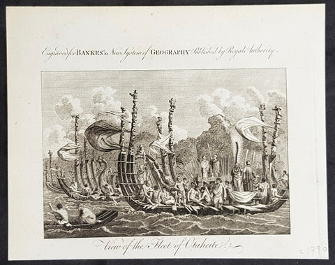
1787 Bankes Antique Print of The Tahitian Fleet - Capt Cooks 3rd Voyage in 1777
- Title : View of the Fleet of Otaheite
- Size: 9 1/2in x 7 1/2in (240mm x 190mm)
- Ref #: 21397-1
- Date : 1787
- Condition: (A+) Fine Condition
Description:
This fine original cooper-plate engraved antique print of Matavai Bay and the Island of Tahiti during Captain Cooks visit to the Island during his 3rd Voyage of Discovery to the South Seas in 1777 was published in Thomas Bankes 1787 edition of A New, Royal and Authentic System of Universal Geography, Antient and Modern..... printed by Charles Cook, London.
General Definitions:
Paper thickness and quality: - Heavy and stable
Paper color : - off white
Age of map color: -
Colors used: -
General color appearance: -
Paper size: - 9 1/2in x 7 1/2in (240mm x 190mm)
Plate size: - 9 1/2in x 7 1/2in (240mm x 190mm)
Margins: - Min 1/2in (12mm)
Imperfections:
Margins: - None
Plate area: - None
Verso: - None
Background:
CooksThird Voyage (1776–79)
On his last voyage, Cook again commanded HMS Resolution, while Captain Charles Clerke commanded HMS Discovery. The voyage was ostensibly planned to return the Pacific Islander, Omai to Tahiti, or so the public were led to believe. The trip\\\'s principal goal was to locate a Northwest Passage around the American continent. After dropping Omai at Tahiti, Cook travelled north and in 1778 became the first European to begin formal contact with the Hawaiian Islands. After his initial landfall in January 1778 at Waimea harbour, Kauai, Cook named the archipelago the \\\"Sandwich Islands\\\" after the fourth Earl of Sandwich—the acting First Lord of the Admiralty.
From the Sandwich Islands Cook sailed north and then north-east to explore the west coast of North America north of the Spanish settlements in Alta California. He made landfall on the Oregon coast at approximately 44°30′ north latitude, naming his landing point Cape Foulweather. Bad weather forced his ships south to about 43° north before they could begin their exploration of the coast northward. He unknowingly sailed past the Strait of Juan de Fuca, and soon after entered Nootka Sound on Vancouver Island. He anchored near the First Nations village of Yuquot. Cook\\\'s two ships remained in Nootka Sound from 29 March to 26 April 1778, in what Cook called Ship Cove, now Resolution Cove, at the south end of Bligh Island, about 5 miles (8 km) east across Nootka Sound from Yuquot, lay a Nuu-chah-nulth village (whose chief Cook did not identify but may have been Maquinna). Relations between Cook\\\'s crew and the people of Yuquot were cordial if sometimes strained. In trading, the people of Yuquot demanded much more valuable items than the usual trinkets that had worked in Hawaii. Metal objects were much desired, but the lead, pewter, and tin traded at first soon fell into disrepute. The most valuable items which the British received in trade were sea otter pelts. During the stay, the Yuquot \\\"hosts\\\" essentially controlled the trade with the British vessels; the natives usually visited the British vessels at Resolution Cove instead of the British visiting the village of Yuquot at Friendly Cove.
After leaving Nootka Sound, Cook explored and mapped the coast all the way to the Bering Strait, on the way identifying what came to be known as Cook Inlet in Alaska. In a single visit, Cook charted the majority of the North American north-west coastline on world maps for the first time, determined the extent of Alaska, and closed the gaps in Russian (from the West) and Spanish (from the South) exploratory probes of the Northern limits of the Pacific.
By the second week of August 1778 Cook was through the Bering Strait, sailing into the Chukchi Sea. He headed north-east up the coast of Alaska until he was blocked by sea ice. His furthest north was 70 degrees 44 minutes. Cook then sailed west to the Siberian coast, and then south-east down the Siberian coast back to the Bering Strait. By early September 1778 he was back in the Bering Sea to begin the trip to the Sandwich (Hawaiian) Islands. He became increasingly frustrated on this voyage, and perhaps began to suffer from a stomach ailment; it has been speculated that this led to irrational behaviour towards his crew, such as forcing them to eat walrus meat, which they had pronounced inedible.
Cook returned to Hawaii in 1779. After sailing around the archipelago for some eight weeks, he made landfall at Kealakekua Bay, on \\\'Hawaii Island\\\', largest island in the Hawaiian Archipelago. Cook\\\'s arrival coincided with the Makahiki, a Hawaiian harvest festival of worship for the Polynesian god Lono. Coincidentally the form of Cook\\\'s ship, HMS Resolution, or more particularly the mast formation, sails and rigging, resembled certain significant artefacts that formed part of the season of worship. Similarly, Cook\\\'s clockwise route around the island of Hawaii before making landfall resembled the processions that took place in a clockwise direction around the island during the Lono festivals. It has been argued (most extensively by Marshall Sahlins) that such coincidences were the reasons for Cook\\\'s (and to a limited extent, his crew\\\'s) initial deification by some Hawaiians who treated Cook as an incarnation of Lono. Though this view was first suggested by members of Cook\\\'s expedition, the idea that any Hawaiians understood Cook to be Lono, and the evidence presented in support of it, were challenged in 1992.
After a month\\\'s stay, Cook attempted to resume his exploration of the Northern Pacific. Shortly after leaving Hawaii Island, however, the Resolution\\\'s foremast broke, so the ships returned to Kealakekua Bay for repairs.
Tensions rose, and a number of quarrels broke out between the Europeans and Hawaiians at Kealakekua Bay. An unknown group of Hawaiians took one of Cook\\\'s small boats. The evening when the cutter was taken, the people had become \\\"insolent\\\" even with threats to fire upon them. Cook was forced into a wild goose chase that ended with his return to the ship frustrated.[53] He attempted to kidnap and ransom the King of Hawaiʻi, Kalaniʻōpuʻu.
That following day, 14 February 1779, Cook marched through the village to retrieve the King. Cook took the King (aliʻi nui) by his own hand and led him willingly away. One of Kalaniʻōpuʻu\\\'s favorite wives, Kanekapolei and two chiefs approached the group as they were heading to boats. They pleaded with the king not to go until he stopped and sat where he stood. An old kahuna (priest), chanting rapidly while holding out a coconut, attempted to distract Cook and his men as a large crowd began to form at the shore. The king began to understand that Cook was his enemy. As Cook turned his back to help launch the boats, he was struck on the head by the villagers and then stabbed to death as he fell on his face in the surf. He was first struck on the head with a club by a chief named Kalaimanokahoʻowaha or Kanaʻina (namesake of Charles Kana\\\'ina) and then stabbed by one of the king\\\'s attendants, Nuaa. The Hawaiians carried his body away towards the back of the town, still visible to the ship through their spyglass. Four marines, Corporal James Thomas, Private Theophilus Hinks, Private Thomas Fatchett and Private John Allen, were also killed and two others were wounded in the confrontation.
The esteem which the islanders nevertheless held for Cook caused them to retain his body. Following their practice of the time, they prepared his body with funerary rituals usually reserved for the chiefs and highest elders of the society. The body was disembowelled, baked to facilitate removal of the flesh, and the bones were carefully cleaned for preservation as religious icons in a fashion somewhat reminiscent of the treatment of European saints in the Middle Ages. Some of Cook\\\'s remains, thus preserved, were eventually returned to his crew for a formal burial at sea.
Clerke assumed leadership of the expedition, and made a final attempt to pass through the Bering Strait. He died from tuberculosis on 22 August 1779 and John Gore, a veteran of Cook\\\'s first voyage, took command of Resolution and of the expedition. James King replaced Gore in command of Discovery. The expedition returned home, reaching England in October 1780. After their arrival in England, King completed Cook\\\'s account of the voyage.
David Samwell, who sailed with Cook on Resolution, wrote of him: \\\"He was a modest man, and rather bashful; of an agreeable lively conversation, sensible and intelligent. In temper he was somewhat hasty, but of a disposition the most friendly, benevolent and humane. His person was above six feet high: and, though a good looking man, he was plain both in dress and appearance. His face was full of expression: his nose extremely well shaped: his eyes which were small and of a brown cast, were quick and piercing; his eyebrows prominent, which gave his countenance altogether an air of austerity.
Tahiti previously also known as Otaheite is the largest island in the Windward group of French Polynesia. The island is located in the archipelago of the Society Islands in the central Southern Pacific Ocean.
The first European to have visited Tahiti according to existing records was lieutenant Samuel Wallis, who was circumnavigating the globe in HMS Dolphin, sighting the island on 18 June 1767, and eventually harboring in Matavai Bay. This bay was situated on the territory of the chiefdom of Pare-Arue, governed by Tu (Tu-nui-e-a\\\\\\\'a-i-te-Atua) and his regent Tutaha, and the chiefdom of Ha apape, governed by Amo and his wife Oberea (Purea). Wallis named the island King Georges Island. The first contacts were difficult, since on the 24 and 26 June 1767, Tahitian warriors in canoes showed aggression towards the British, hurling stones from their slings. In retaliation, the British sailors opened fire on the warriors in the canoes and on the hills. In reaction to this powerful counter-attack, the Tahitians laid down peace offerings for the British. Following this episode, Samuel Wallis was able to establish cordial relations with the female chieftain “Oberea “ (Purea) and remained on the island until 27 July 1767.
In July 1768, Captain James Cook was commissioned by the Royal Society and on orders from the Lords Commissioners of the Admiralty to observe the transit of Venus across the sun, a phenomenon that would be visible from Tahiti on 3 June 1769. He arrived in Tahitis Matavai Bay, commanding the HMS Endeavour on 12 April 1769. On 14 April, Cook met with Tutaha and Tepau. On 15 April, Cook picked the site for a fortified camp at Point Venus along with Banks, Parkinson, Daniel Solander, to protect Charles Greens observatory. The length of stay enabled them to undertake for the first time real ethnographic and scientific observations of the island. Assisted by the botanist Joseph Banks, and by the artist Sydney Parkinson, Cook gathered valuable information on the fauna and flora, as well as the native society, language and customs, including the proper name of the island, Otaheite. On 28 April, Cook met Purea and Tupaia, and Tupaia befriended Banks following the transit. On 21 June, Amo visited Cook, and then on 25 June, Pohuetea visited, signifying another chief seeking to ally himself with the British.
Cook and Banks circumnavigated the island from 26 June to 1 July. On the exploration, they met Ahio, chief of Ha apaiano o or Papenoo, Rita, chief of Hitia a, Pahairro, chief of Pueu, Vehiatua, chief of Tautra, Matahiapo, chief of Teahupo o, Tutea, chief of Vaira o, and Moe, chief of Afa\\\\\\\'Ahiti. In Papara, guided by Tupaia, they investigated the ruins of Mahaiatea marae, an impressive structure containing a stone pyramid or ahu, measuring 44 feet high, 267 feet long and 87 feet wide. Cook and the Endeavour departed Tahiti on 13 July 1769, taking Raiatean navigator Tupaia along for his geographic knowledge of the islands.
Cook returned to Tahiti between 15 August and 1 September 1773, greeted by the chiefs Tai and Puhi, besides the youg ari i Vehiatua II and his stepfather Ti itorea. Cook anchored in Vaitepiha Bay before returning to Point Venus where he met Tu, the paramount chief. Cook picked up two passengers from Tahiti during this trip, Porea and Ma\\\\\\\'i, with Hitihiti later replacing Porea when Cook stopped at Raiatea. Cook took Hitihiti to Tahiti on 22 April, during his return leg. Then, Cook departed Tahiti on 14 May 1774.
During his final visit, Cook returned Mai to Tahiti on 12 Aug. 1777, after Mais long visit in England. Cook also brought two Maori from Queen Charlotte Sound, Te Weherua and Koa. Cook first harbored in Vaitepiha Bay, where he visited Vehiatua II s funeral bier and the prefabricated Spanish mission house. Cook also met Vehiatua III, and inscribed on the back of the Spanish cross, Georgius tertius Rex Annis 1767, 69, 73, 74 & 77, as a counterpoint to Christus Vincit Carolus III imperat 1774 on the front. On 23 Aug., Cook sailed for Matavai Bay, where he met Tu, his father Teu, his mother Tetupaia, his brothers Ari ipaea and Vaetua, and his sisters Ari ipaea-vahine, Tetua-te-ahamai, and Auo. Cook also observed a human sacrifice, taata tapu, at the Utu-ai-mahurau marae, and 49 skulls from previous victims.
On 29 Sept. 1777, Cook sailed for Papetoai Bay on Moorea. Cook met Mahine in an act of friendship on 3 Oct., though he was an enemy of Tu. When a goat kid was stolen on 6 Oct., Cook in a rampage, ordered the burning of houses and canoes until it was returned. Cook sailed for Huahine on 11 Oct., Raiatea on 2 Nov., and Borabora on 7 Dec.
On 26 October 1788, HMS Bounty, under the command of Captain William Bligh, landed in Tahiti with the mission of carrying Tahitian breadfruit trees (Tahitian: uru) to the Caribbean. Sir Joseph Banks, the botanist from James Cooks first expedition, had concluded that this plant would be ideal to feed the African slaves working in the Caribbean plantations at very little cost. The crew remained in Tahiti for about five months, the time needed to transplant the seedlings of the trees. Three weeks after leaving Tahiti, on 28 April 1789, the crew mutinied on the initiative of Fletcher Christian. The mutineers seized the ship and set the captain and most of those members of the crew who remained loyal to him adrift in a ship\\\\\\\'s boat. A group of mutineers then went back to settle in Tahiti.
Although various explorers had refused to get involved in tribal conflicts, the mutineers from the Bounty offered their services as mercenaries and furnished arms to the family which became the Pōmare Dynasty. The chief Tū knew how to use their presence in the harbours favoured by sailors to his advantage. As a result of his alliance with the mutineers, he succeeded in considerably increasing his supremacy over the island of Tahiti.
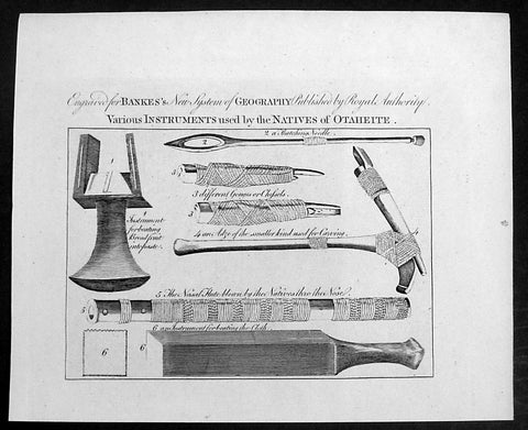
1787 Bankes Antique Print Tahitian Tools, Instruments & Flute - Capt Cook 1769
- Title : Various Instruments used by the Natives of Ohaheite
- Size: 9 1/2in x 7 1/2in (240mm x 190mm)
- Ref #: 21670-1
- Date : 1787
- Condition: (A+) Fine Condition
Description:
This fine original cooper-plate engraved antique print of various Instruments and tools of Tahiti and surrounding Islands visited by Captain James Cook in 1769, during his First Voyage of Discovery was published in Thomas Bankes 1787 edition of A New, Royal and Authentic System of Universal Geography, Antient and Modern..... printed by Charles Cook, London.
The tools & instruments listed are;
The tools & instruments listed are;
1. Instrument for beating Breadfruit into paste
2. Thatching Needle
3. 3. Different Gouges or Chisels
4. An Adze of the smaller kind used for carving
5. The Nasal Flute blown by the Natives thro the nose
6. An instrument for beating the cloth
General Definitions:
Paper thickness and quality: - Heavy and stable
Paper color : - off white
Age of map color: -
Colors used: -
General color appearance: -
Paper size: - 14in x 9in (355mm x 230mm)
Plate size: - 12in x 7 1/2in (305mm x 190mm)
Margins: - Min 1/2in (12mm)
Imperfections:
Margins: - None
Plate area: - None
Verso: - None
Background:
Cooks Voyages 1768–1779
First voyage (1768–71)
In 1766, the Admiralty engaged Cook to command a scientific voyage to the Pacific Ocean. The purpose of the voyage was to observe and record the transit of Venus across the Sun for the benefit of a Royal Society inquiry into a means of determining longitude. Cook, at the age of 39, was promoted to lieutenant to grant him sufficient status to take the command. For its part the Royal Society agreed that Cook would receive a one hundred guinea gratuity in addition to his Naval pay.
The expedition sailed aboard HMS Endeavour, departing England on 26 August 1768. Cook and his crew rounded Cape Horn and continued westward across the Pacific to arrive at Tahiti on 13 April 1769, where the observations of the Venus Transit were made. However, the result of the observations was not as conclusive or accurate as had been hoped. Once the observations were completed, Cook opened the sealed orders which were additional instructions from the Admiralty for the second part of his voyage: to search the south Pacific for signs of the postulated rich southern continent of Terra Australis. Cook then sailed to New Zealand and mapped the complete coastline, making only some minor errors. He then voyaged west, reaching the south-eastern coast of Australia on 19 April 1770, and in doing so his expedition became the first recorded Europeans to have encountered its eastern coastline.
On 23 April he made his first recorded direct observation of indigenous Australians at Brush Island near Bawley Point, noting in his journal: “...and were so near the Shore as to distinguish several people upon the Sea beach they appear\'d to be of a very dark or black Colour but whether this was the real colour of their skins or the Clothes they might have on I know not. On 29 April Cook and crew made their first landfall on the mainland of the continent at a place now known as the Kurnell Peninsula. Cook originally christened the area as \"Stingray Bay\", but later he crossed this out and named it Botany Bay after the unique specimens retrieved by the botanists Joseph Banks and Daniel Solander. It is here that James Cook made first contact with an aboriginal tribe known as the Gweagal.
After his departure from Botany Bay he continued northwards. He stopped at Bustard Bay (now known as Seventeen Seventy or 1770) at 8 o’clock on 23 May 1770. On 24 May Cook and Banks and others went ashore. Continuing north, on 11 June a mishap occurred when HMS Endeavour ran aground on a shoal of the Great Barrier Reef, and then nursed into a river mouth on 18 June 1770. The ship was badly damaged and his voyage was delayed almost seven weeks while repairs were carried out on the beach (near the docks of modern Cooktown, Queensland, at the mouth of the Endeavour River). The voyage then continued, sailing through Torres Strait and on 22 August Cook landed on Possession Island, where he claimed the entire coastline that he had just explored as British territory. He returned to England via Batavia (modern Jakarta, Indonesia), where many in his crew succumbed to malaria, and then the Cape of Good Hope, arriving at the island of Saint Helena on 12 July 1771.
Cook\'s journals were published upon his return, and he became something of a hero among the scientific community. Among the general public, however, the aristocratic botanist Joseph Banks was a greater hero. Banks even attempted to take command of Cook\'s second voyage, but removed himself from the voyage before it began, and Johann Reinhold Forster and his son Georg Forster were taken on as scientists for the voyage. Cook\'s son George was born five days before he left for his second voyage.
Tahiti previously also known as Otaheite is the largest island in the Windward group of French Polynesia. The island is located in the archipelago of the Society Islands in the central Southern Pacific Ocean.
The first European to have visited Tahiti according to existing records was lieutenant Samuel Wallis, who was circumnavigating the globe in HMS Dolphin, sighting the island on 18 June 1767, and eventually harboring in Matavai Bay. This bay was situated on the territory of the chiefdom of Pare-Arue, governed by Tu (Tu-nui-e-a\\\'a-i-te-Atua) and his regent Tutaha, and the chiefdom of Ha apape, governed by Amo and his wife Oberea (Purea). Wallis named the island King Georges Island. The first contacts were difficult, since on the 24 and 26 June 1767, Tahitian warriors in canoes showed aggression towards the British, hurling stones from their slings. In retaliation, the British sailors opened fire on the warriors in the canoes and on the hills. In reaction to this powerful counter-attack, the Tahitians laid down peace offerings for the British. Following this episode, Samuel Wallis was able to establish cordial relations with the female chieftain “Oberea “ (Purea) and remained on the island until 27 July 1767.
In July 1768, Captain James Cook was commissioned by the Royal Society and on orders from the Lords Commissioners of the Admiralty to observe the transit of Venus across the sun, a phenomenon that would be visible from Tahiti on 3 June 1769. He arrived in Tahitis Matavai Bay, commanding the HMS Endeavour on 12 April 1769. On 14 April, Cook met with Tutaha and Tepau. On 15 April, Cook picked the site for a fortified camp at Point Venus along with Banks, Parkinson, Daniel Solander, to protect Charles Greens observatory. The length of stay enabled them to undertake for the first time real ethnographic and scientific observations of the island. Assisted by the botanist Joseph Banks, and by the artist Sydney Parkinson, Cook gathered valuable information on the fauna and flora, as well as the native society, language and customs, including the proper name of the island, Otaheite. On 28 April, Cook met Purea and Tupaia, and Tupaia befriended Banks following the transit. On 21 June, Amo visited Cook, and then on 25 June, Pohuetea visited, signifying another chief seeking to ally himself with the British.
Cook and Banks circumnavigated the island from 26 June to 1 July. On the exploration, they met Ahio, chief of Ha apaiano o or Papenoo, Rita, chief of Hitia a, Pahairro, chief of Pueu, Vehiatua, chief of Tautra, Matahiapo, chief of Teahupo o, Tutea, chief of Vaira o, and Moe, chief of Afa\\\'Ahiti. In Papara, guided by Tupaia, they investigated the ruins of Mahaiatea marae, an impressive structure containing a stone pyramid or ahu, measuring 44 feet high, 267 feet long and 87 feet wide. Cook and the Endeavour departed Tahiti on 13 July 1769, taking Raiatean navigator Tupaia along for his geographic knowledge of the islands.
Cook returned to Tahiti between 15 August and 1 September 1773, greeted by the chiefs Tai and Puhi, besides the youg ari i Vehiatua II and his stepfather Ti itorea. Cook anchored in Vaitepiha Bay before returning to Point Venus where he met Tu, the paramount chief. Cook picked up two passengers from Tahiti during this trip, Porea and Ma\\\'i, with Hitihiti later replacing Porea when Cook stopped at Raiatea. Cook took Hitihiti to Tahiti on 22 April, during his return leg. Then, Cook departed Tahiti on 14 May 1774.
During his final visit, Cook returned Mai to Tahiti on 12 Aug. 1777, after Mais long visit in England. Cook also brought two Maori from Queen Charlotte Sound, Te Weherua and Koa. Cook first harbored in Vaitepiha Bay, where he visited Vehiatua II s funeral bier and the prefabricated Spanish mission house. Cook also met Vehiatua III, and inscribed on the back of the Spanish cross, Georgius tertius Rex Annis 1767, 69, 73, 74 & 77, as a counterpoint to Christus Vincit Carolus III imperat 1774 on the front. On 23 Aug., Cook sailed for Matavai Bay, where he met Tu, his father Teu, his mother Tetupaia, his brothers Ari ipaea and Vaetua, and his sisters Ari ipaea-vahine, Tetua-te-ahamai, and Auo. Cook also observed a human sacrifice, taata tapu, at the Utu-ai-mahurau marae, and 49 skulls from previous victims.
On 29 Sept. 1777, Cook sailed for Papetoai Bay on Moorea. Cook met Mahine in an act of friendship on 3 Oct., though he was an enemy of Tu. When a goat kid was stolen on 6 Oct., Cook in a rampage, ordered the burning of houses and canoes until it was returned. Cook sailed for Huahine on 11 Oct., Raiatea on 2 Nov., and Borabora on 7 Dec.
On 26 October 1788, HMS Bounty, under the command of Captain William Bligh, landed in Tahiti with the mission of carrying Tahitian breadfruit trees (Tahitian: uru) to the Caribbean. Sir Joseph Banks, the botanist from James Cooks first expedition, had concluded that this plant would be ideal to feed the African slaves working in the Caribbean plantations at very little cost. The crew remained in Tahiti for about five months, the time needed to transplant the seedlings of the trees. Three weeks after leaving Tahiti, on 28 April 1789, the crew mutinied on the initiative of Fletcher Christian. The mutineers seized the ship and set the captain and most of those members of the crew who remained loyal to him adrift in a ship\\\'s boat. A group of mutineers then went back to settle in Tahiti.
Although various explorers had refused to get involved in tribal conflicts, the mutineers from the Bounty offered their services as mercenaries and furnished arms to the family which became the Pōmare Dynasty. The chief Tū knew how to use their presence in the harbours favoured by sailors to his advantage. As a result of his alliance with the mutineers, he succeeded in considerably increasing his supremacy over the island of Tahiti.
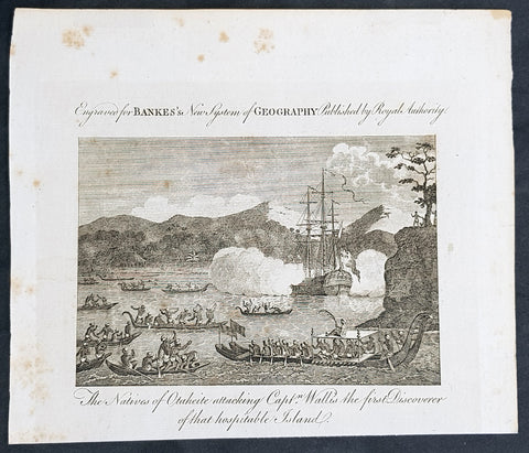
1787 Bankes Antique Print Tahitians Attacking Capt. Wallis, Matavai Bay Tahiti in 1767
- Title : The Natives of Ohaheite attacking Capt. Wallis the first Discoverer of that Hospitable Island
- Size: 9 1/2in x 7 1/2in (240mm x 190mm)
- Ref #: 21524-1
- Date : 1787
- Condition: (A+) Fine Condition
Description:
This fine original cooper-plate engraved antique print of Captain Samuel Wallis being attacked in Matavai Bay, Tahiti on 24th and 26th of June 1767 was published in Thomas Bankes 1787 edition of A New, Royal and Authentic System of Universal Geography, Antient and Modern..... printed by Charles Cook, London.
General Definitions:
Paper thickness and quality: - Heavy and stable
Paper color : - off white
Age of map color: -
Colors used: -
General color appearance: -
Paper size: - 9 1/2in x 7 1/2in (240mm x 190mm)
Plate size: - 9 1/2in x 7 1/2in (240mm x 190mm)
Margins: - Min 1/2in (12mm)
Imperfections:
Margins: - None
Plate area: - None
Verso: - None
Background:
Tahiti previously also known as Otaheite is the largest island in the Windward group of French Polynesia. The island is located in the archipelago of the Society Islands in the central Southern Pacific Ocean.
The first European to have visited Tahiti according to existing records was lieutenant Samuel Wallis, who was circumnavigating the globe in HMS Dolphin, sighting the island on 18 June 1767, and eventually harboring in Matavai Bay. This bay was situated on the territory of the chiefdom of Pare-Arue, governed by Tu (Tu-nui-e-a\\\\\\\'a-i-te-Atua) and his regent Tutaha, and the chiefdom of Ha apape, governed by Amo and his wife Oberea (Purea). Wallis named the island King Georges Island. The first contacts were difficult, since on the 24 and 26 June 1767, Tahitian warriors in canoes showed aggression towards the British, hurling stones from their slings. In retaliation, the British sailors opened fire on the warriors in the canoes and on the hills. In reaction to this powerful counter-attack, the Tahitians laid down peace offerings for the British. Following this episode, Samuel Wallis was able to establish cordial relations with the female chieftain “Oberea “ (Purea) and remained on the island until 27 July 1767.
In July 1768, Captain James Cook was commissioned by the Royal Society and on orders from the Lords Commissioners of the Admiralty to observe the transit of Venus across the sun, a phenomenon that would be visible from Tahiti on 3 June 1769. He arrived in Tahitis Matavai Bay, commanding the HMS Endeavour on 12 April 1769. On 14 April, Cook met with Tutaha and Tepau. On 15 April, Cook picked the site for a fortified camp at Point Venus along with Banks, Parkinson, Daniel Solander, to protect Charles Greens observatory. The length of stay enabled them to undertake for the first time real ethnographic and scientific observations of the island. Assisted by the botanist Joseph Banks, and by the artist Sydney Parkinson, Cook gathered valuable information on the fauna and flora, as well as the native society, language and customs, including the proper name of the island, Otaheite. On 28 April, Cook met Purea and Tupaia, and Tupaia befriended Banks following the transit. On 21 June, Amo visited Cook, and then on 25 June, Pohuetea visited, signifying another chief seeking to ally himself with the British.
Cook and Banks circumnavigated the island from 26 June to 1 July. On the exploration, they met Ahio, chief of Ha apaiano o or Papenoo, Rita, chief of Hitia a, Pahairro, chief of Pueu, Vehiatua, chief of Tautra, Matahiapo, chief of Teahupo o, Tutea, chief of Vaira o, and Moe, chief of Afa\\\\\\\'Ahiti. In Papara, guided by Tupaia, they investigated the ruins of Mahaiatea marae, an impressive structure containing a stone pyramid or ahu, measuring 44 feet high, 267 feet long and 87 feet wide. Cook and the Endeavour departed Tahiti on 13 July 1769, taking Raiatean navigator Tupaia along for his geographic knowledge of the islands.
Cook returned to Tahiti between 15 August and 1 September 1773, greeted by the chiefs Tai and Puhi, besides the youg ari i Vehiatua II and his stepfather Ti itorea. Cook anchored in Vaitepiha Bay before returning to Point Venus where he met Tu, the paramount chief. Cook picked up two passengers from Tahiti during this trip, Porea and Ma\\\\\\\'i, with Hitihiti later replacing Porea when Cook stopped at Raiatea. Cook took Hitihiti to Tahiti on 22 April, during his return leg. Then, Cook departed Tahiti on 14 May 1774.
During his final visit, Cook returned Mai to Tahiti on 12 Aug. 1777, after Mais long visit in England. Cook also brought two Maori from Queen Charlotte Sound, Te Weherua and Koa. Cook first harbored in Vaitepiha Bay, where he visited Vehiatua II s funeral bier and the prefabricated Spanish mission house. Cook also met Vehiatua III, and inscribed on the back of the Spanish cross, Georgius tertius Rex Annis 1767, 69, 73, 74 & 77, as a counterpoint to Christus Vincit Carolus III imperat 1774 on the front. On 23 Aug., Cook sailed for Matavai Bay, where he met Tu, his father Teu, his mother Tetupaia, his brothers Ari ipaea and Vaetua, and his sisters Ari ipaea-vahine, Tetua-te-ahamai, and Auo. Cook also observed a human sacrifice, taata tapu, at the Utu-ai-mahurau marae, and 49 skulls from previous victims.
On 29 Sept. 1777, Cook sailed for Papetoai Bay on Moorea. Cook met Mahine in an act of friendship on 3 Oct., though he was an enemy of Tu. When a goat kid was stolen on 6 Oct., Cook in a rampage, ordered the burning of houses and canoes until it was returned. Cook sailed for Huahine on 11 Oct., Raiatea on 2 Nov., and Borabora on 7 Dec.
On 26 October 1788, HMS Bounty, under the command of Captain William Bligh, landed in Tahiti with the mission of carrying Tahitian breadfruit trees (Tahitian: uru) to the Caribbean. Sir Joseph Banks, the botanist from James Cooks first expedition, had concluded that this plant would be ideal to feed the African slaves working in the Caribbean plantations at very little cost. The crew remained in Tahiti for about five months, the time needed to transplant the seedlings of the trees. Three weeks after leaving Tahiti, on 28 April 1789, the crew mutinied on the initiative of Fletcher Christian. The mutineers seized the ship and set the captain and most of those members of the crew who remained loyal to him adrift in a ship\\\\\\\'s boat. A group of mutineers then went back to settle in Tahiti.
Although various explorers had refused to get involved in tribal conflicts, the mutineers from the Bounty offered their services as mercenaries and furnished arms to the family which became the Pōmare Dynasty. The chief Tū knew how to use their presence in the harbours favoured by sailors to his advantage. As a result of his alliance with the mutineers, he succeeded in considerably increasing his supremacy over the island of Tahiti.
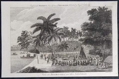
1787 Bankes Antique Print View of Nomuka Island, Tonga - Cooks Voyages in 1777
- Title : View in Anamooka and the Inhabitants
- Size: 14in x 9in (355mm x 230mm)
- Ref #: 21527
- Date : 1787
- Condition: (A+) Fine Condition
Description:
This fine original cooper-plate engraved antique print of a view of the Island of Nomuka, a small island in the southern part of the Ha apai islands, in the Kingdom of Tonga, during Captain Cooks 3rd Voyage of discovery to the South Seas in 1777 was published in Thomas Bankes 1787 edition of A New, Royal and Authentic System of Universal Geography, Antient and Modern..... printed by Charles Cook, London.
General Definitions:
Paper thickness and quality: - Heavy and stable
Paper color : - off white
Age of map color: -
Colors used: -
General color appearance: -
Paper size: - 14in x 9in (355mm x 230mm)
Plate size: - 12in x 7 1/2in (305mm x 190mm)
Margins: - Min 1/2in (12mm)
Imperfections:
Margins: - None
Plate area: - None
Verso: - None
Background:
Nomuka is a small island in the southern part of the Ha apai group of islands in the Kingdom of Tonga. It is part of the Nomuka Group of islands, also called the Otu Muomua.
Nomuka, is 7 square kilometres in area and contains a large, brackish lake (Ano Lahi) in the middle, and also three other smaller lakes—Ano Haamea, Ano Fungalei, and Molou. There are approximately 400-500 inhabitants who subsist on fishing, farming, and remittances from family members abroad. The island has a secondary school, two primary schools, and a kindergarten. It also has seven churches.
The island is accessible by boat only. Boats leave weekly from Nukualofa and Lifuka, Haapai. There is one guesthouse on the island, and three or four small fale koloa, or convenience stores.
Notable historic visitors include Abel Tasman, Captain Cook, Captain Bligh, and William Mariner. The Dutch Abel Tasman made the first European discovery of the island on 24 January 1643. A party went ashore to get water, and the description of the huge lake they brought back afterwards leaves little doubt about the identification. Tasman called it Rotterdam island, after the city of Rotterdam, a major port in the Netherlands, and noted in his maps the indigenous name of Amamocka, a misspelling of ʻa Nomuka, ʻa being a subject indicating article. We also find the name of Amorkakij for Nomuka iki. Captain Bligh in the Bounty spent 3 days wooding and watering at Nomuka in April 1789. The Mutiny on the Bounty occurred the day after they left.
Cooks Diary.........as it was, Cook did not encounter the Tongan islands until his Second Voyage, when he stopped at both \'Eua and Tongatapu (or, by Tasman\'s nomenclature, Middleburg and Amsterdam respectively) in October of 1773. Here he was \"welcomed a shore by acclamations from an immence [sic] crowd of Men and Women not one of which had so much as a stick in their hands\".
Indeed, Cook found the islanders to be so accommodating that he returned to the archipelago in 1774 on his way back from New Zealand. Stopping at the island of Nomuka, Cook was sought out by name, and with this \"proof that these people have a communication with Amsterdam \", the cultural unity of the islands was established.
It was at this time that he famously named the island group the Friendly Archipelago, \"as a lasting friendship seems to subsist among the Inhabitants and their Courtesy to Strangers intitles [sic] them to that Name.\"
Cook\'s Third Voyage also included a visit to Tonga, this time for a stay of several months. Cook first dropped anchor at Nomuka in May, and then, at the invitation of the great chief Finau, travelled to another island, Lifuka. Here, Cook and his men were treated to such entertainments as \"whould [sic] have met with universal applause on a European Theatre.
Cook\'s Third Voyage (1776-1779)
In the course of his first two voyages, Cook circumnavigated the globe twice, sailed extensively into the Antarctic, and charted coastlines from Newfoundland to New Zealand. Following these achievements, Cook\'s third voyage was organized to seek an efficient route from England to southern and eastern Asia that would not entail rounding the Cape of Good Hope. The search for such a Northwest (or Northeast) Passage had been on the agenda of northern European mariners and merchants since the beginning of European expansion in the late fifteenth century. England\'s growing economic and colonial interests in India in the later eighteenth century provided the stimulus for the latest exploration for this route.
Cook, again in command of the Resolution, was to approach the Northwest Passage from the Pacific accompanied by a second ship, the Discovery, captained by Charles Clerke. The ships left England separately, regrouped at Cape Town, and continued on to Tasmania, New Zealand, and Tahiti. The expedition then sailed north and made landfall at Christmas Island and the Hawaiian Islands. Cook continued northward and charted the west coast of North America from Northern California as far as the Bering Strait. He returned to Hawaii for the winter and was killed in a skirmish with natives on February 14, 1779. Upon Cook\'s death, Clerke took command of the expedition but died six months later. The ships returned to England in 1780 under John Gore, who had commanded the Discovery after Cook\'s death. From start to finish, the voyage had lasted more than four years. (Ref Tooley; M&B; Clancy)
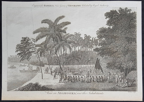
1787 Bankes Antique Print View of Nomuka Island, Tonga - Cooks Voyages in 1777
- Title : View in Anamooka and the Inhabitants
- Size: 14in x 9in (355mm x 230mm)
- Ref #: 21643
- Date : 1787
- Condition: (A+) Fine Condition
Description:
This fine original cooper-plate engraved antique print of a view of the Island of Nomuka, a small island in the southern part of the Ha apai islands, in the Kingdom of Tonga, during Captain Cooks 3rd Voyage of discovery to the South Seas in 1777 was published in Thomas Bankes 1787 edition of A New, Royal and Authentic System of Universal Geography, Antient and Modern..... printed by Charles Cook, London.
General Definitions:
Paper thickness and quality: - Heavy and stable
Paper color : - off white
Age of map color: -
Colors used: -
General color appearance: -
Paper size: - 14in x 9in (355mm x 230mm)
Plate size: - 12in x 7 1/2in (305mm x 190mm)
Margins: - Min 1/2in (12mm)
Imperfections:
Margins: - None
Plate area: - None
Verso: - None
Background:
Nomuka is a small island in the southern part of the Ha apai group of islands in the Kingdom of Tonga. It is part of the Nomuka Group of islands, also called the Otu Muomua.
Nomuka, is 7 square kilometres in area and contains a large, brackish lake (Ano Lahi) in the middle, and also three other smaller lakes—Ano Haamea, Ano Fungalei, and Molou. There are approximately 400-500 inhabitants who subsist on fishing, farming, and remittances from family members abroad. The island has a secondary school, two primary schools, and a kindergarten. It also has seven churches.
The island is accessible by boat only. Boats leave weekly from Nukualofa and Lifuka, Haapai. There is one guesthouse on the island, and three or four small fale koloa, or convenience stores.
Notable historic visitors include Abel Tasman, Captain Cook, Captain Bligh, and William Mariner. The Dutch Abel Tasman made the first European discovery of the island on 24 January 1643. A party went ashore to get water, and the description of the huge lake they brought back afterwards leaves little doubt about the identification. Tasman called it Rotterdam island, after the city of Rotterdam, a major port in the Netherlands, and noted in his maps the indigenous name of Amamocka, a misspelling of ʻa Nomuka, ʻa being a subject indicating article. We also find the name of Amorkakij for Nomuka iki. Captain Bligh in the Bounty spent 3 days wooding and watering at Nomuka in April 1789. The Mutiny on the Bounty occurred the day after they left.
Cooks Diary.........as it was, Cook did not encounter the Tongan islands until his Second Voyage, when he stopped at both \'Eua and Tongatapu (or, by Tasman\'s nomenclature, Middleburg and Amsterdam respectively) in October of 1773. Here he was \"welcomed a shore by acclamations from an immence [sic] crowd of Men and Women not one of which had so much as a stick in their hands\".
Indeed, Cook found the islanders to be so accommodating that he returned to the archipelago in 1774 on his way back from New Zealand. Stopping at the island of Nomuka, Cook was sought out by name, and with this \"proof that these people have a communication with Amsterdam \", the cultural unity of the islands was established.
It was at this time that he famously named the island group the Friendly Archipelago, \"as a lasting friendship seems to subsist among the Inhabitants and their Courtesy to Strangers intitles [sic] them to that Name.\"
Cook\'s Third Voyage also included a visit to Tonga, this time for a stay of several months. Cook first dropped anchor at Nomuka in May, and then, at the invitation of the great chief Finau, travelled to another island, Lifuka. Here, Cook and his men were treated to such entertainments as \"whould [sic] have met with universal applause on a European Theatre.
Cook\'s Third Voyage (1776-1779)
In the course of his first two voyages, Cook circumnavigated the globe twice, sailed extensively into the Antarctic, and charted coastlines from Newfoundland to New Zealand. Following these achievements, Cook\'s third voyage was organized to seek an efficient route from England to southern and eastern Asia that would not entail rounding the Cape of Good Hope. The search for such a Northwest (or Northeast) Passage had been on the agenda of northern European mariners and merchants since the beginning of European expansion in the late fifteenth century. England\'s growing economic and colonial interests in India in the later eighteenth century provided the stimulus for the latest exploration for this route.
Cook, again in command of the Resolution, was to approach the Northwest Passage from the Pacific accompanied by a second ship, the Discovery, captained by Charles Clerke. The ships left England separately, regrouped at Cape Town, and continued on to Tasmania, New Zealand, and Tahiti. The expedition then sailed north and made landfall at Christmas Island and the Hawaiian Islands. Cook continued northward and charted the west coast of North America from Northern California as far as the Bering Strait. He returned to Hawaii for the winter and was killed in a skirmish with natives on February 14, 1779. Upon Cook\'s death, Clerke took command of the expedition but died six months later. The ships returned to England in 1780 under John Gore, who had commanded the Discovery after Cook\'s death. From start to finish, the voyage had lasted more than four years. (Ref Tooley; M&B; Clancy)
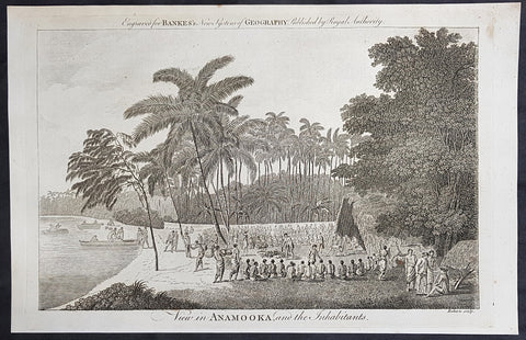
1787 Bankes Antique Print View of Nomuka Island, Tonga - Cooks Voyages in 1777
- Title : View in Anamooka and the Inhabitants
- Size: 14in x 9in (355mm x 230mm)
- Ref #: 40224
- Date : 1787
- Condition: (A+) Fine Condition
Description:
This fine original cooper-plate engraved antique print of a view of the Island of Nomuka, a small island in the southern part of the Ha apai islands, in the Kingdom of Tonga, during Captain Cooks 3rd Voyage of discovery to the South Seas in 1777 was published in Thomas Bankes 1787 edition of A New, Royal and Authentic System of Universal Geography, Antient and Modern..... printed by Charles Cook, London.
General Definitions:
Paper thickness and quality: - Heavy and stable
Paper color : - off white
Age of map color: -
Colors used: -
General color appearance: -
Paper size: - 14in x 9in (355mm x 230mm)
Plate size: - 12in x 7 1/2in (305mm x 190mm)
Margins: - Min 1/2in (12mm)
Imperfections:
Margins: - None
Plate area: - None
Verso: - None
Background:
Nomuka is a small island in the southern part of the Ha apai group of islands in the Kingdom of Tonga. It is part of the Nomuka Group of islands, also called the Otu Muomua.
Nomuka, is 7 square kilometres in area and contains a large, brackish lake (Ano Lahi) in the middle, and also three other smaller lakes—Ano Haamea, Ano Fungalei, and Molou. There are approximately 400-500 inhabitants who subsist on fishing, farming, and remittances from family members abroad. The island has a secondary school, two primary schools, and a kindergarten. It also has seven churches.
The island is accessible by boat only. Boats leave weekly from Nukualofa and Lifuka, Haapai. There is one guesthouse on the island, and three or four small fale koloa, or convenience stores.
Notable historic visitors include Abel Tasman, Captain Cook, Captain Bligh, and William Mariner. The Dutch Abel Tasman made the first European discovery of the island on 24 January 1643. A party went ashore to get water, and the description of the huge lake they brought back afterwards leaves little doubt about the identification. Tasman called it Rotterdam island, after the city of Rotterdam, a major port in the Netherlands, and noted in his maps the indigenous name of Amamocka, a misspelling of ʻa Nomuka, ʻa being a subject indicating article. We also find the name of Amorkakij for Nomuka iki. Captain Bligh in the Bounty spent 3 days wooding and watering at Nomuka in April 1789. The Mutiny on the Bounty occurred the day after they left.
Cooks Diary.........as it was, Cook did not encounter the Tongan islands until his Second Voyage, when he stopped at both \'Eua and Tongatapu (or, by Tasman\'s nomenclature, Middleburg and Amsterdam respectively) in October of 1773. Here he was \"welcomed a shore by acclamations from an immence [sic] crowd of Men and Women not one of which had so much as a stick in their hands\".
Indeed, Cook found the islanders to be so accommodating that he returned to the archipelago in 1774 on his way back from New Zealand. Stopping at the island of Nomuka, Cook was sought out by name, and with this \"proof that these people have a communication with Amsterdam \", the cultural unity of the islands was established.
It was at this time that he famously named the island group the Friendly Archipelago, \"as a lasting friendship seems to subsist among the Inhabitants and their Courtesy to Strangers intitles [sic] them to that Name.\"
Cook\'s Third Voyage also included a visit to Tonga, this time for a stay of several months. Cook first dropped anchor at Nomuka in May, and then, at the invitation of the great chief Finau, travelled to another island, Lifuka. Here, Cook and his men were treated to such entertainments as \"whould [sic] have met with universal applause on a European Theatre.
Cook\'s Third Voyage (1776-1779)
In the course of his first two voyages, Cook circumnavigated the globe twice, sailed extensively into the Antarctic, and charted coastlines from Newfoundland to New Zealand. Following these achievements, Cook\'s third voyage was organized to seek an efficient route from England to southern and eastern Asia that would not entail rounding the Cape of Good Hope. The search for such a Northwest (or Northeast) Passage had been on the agenda of northern European mariners and merchants since the beginning of European expansion in the late fifteenth century. England\'s growing economic and colonial interests in India in the later eighteenth century provided the stimulus for the latest exploration for this route.
Cook, again in command of the Resolution, was to approach the Northwest Passage from the Pacific accompanied by a second ship, the Discovery, captained by Charles Clerke. The ships left England separately, regrouped at Cape Town, and continued on to Tasmania, New Zealand, and Tahiti. The expedition then sailed north and made landfall at Christmas Island and the Hawaiian Islands. Cook continued northward and charted the west coast of North America from Northern California as far as the Bering Strait. He returned to Hawaii for the winter and was killed in a skirmish with natives on February 14, 1779. Upon Cook\'s death, Clerke took command of the expedition but died six months later. The ships returned to England in 1780 under John Gore, who had commanded the Discovery after Cook\'s death. From start to finish, the voyage had lasted more than four years. (Ref Tooley; M&B; Clancy)
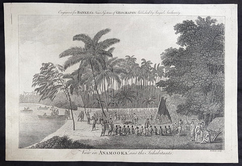
1787 Bankes Antique Print View of Nomuka Island, Tonga - Cooks Voyages in 1777
- Title : View in Anamooka and the Inhabitants
- Size: 14in x 9in (355mm x 230mm)
- Ref #: 21459
- Date : 1787
- Condition: (A+) Fine Condition
Description:
This fine original cooper-plate engraved antique print of a view of the Island of Nomuka, a small island in the southern part of the Ha apai islands, in the Kingdom of Tonga, during Captain Cooks 3rd Voyage of discovery to the South Seas in 1777 was published in Thomas Bankes 1787 edition of A New, Royal and Authentic System of Universal Geography, Antient and Modern..... printed by Charles Cook, London.
General Definitions:
Paper thickness and quality: - Heavy and stable
Paper color : - off white
Age of map color: -
Colors used: -
General color appearance: -
Paper size: - 14in x 9in (355mm x 230mm)
Plate size: - 12in x 7 1/2in (305mm x 190mm)
Margins: - Min 1/2in (12mm)
Imperfections:
Margins: - None
Plate area: - None
Verso: - None
Background:
Nomuka is a small island in the southern part of the Ha apai group of islands in the Kingdom of Tonga. It is part of the Nomuka Group of islands, also called the Otu Muomua.
Nomuka, is 7 square kilometres in area and contains a large, brackish lake (Ano Lahi) in the middle, and also three other smaller lakes—Ano Haamea, Ano Fungalei, and Molou. There are approximately 400-500 inhabitants who subsist on fishing, farming, and remittances from family members abroad. The island has a secondary school, two primary schools, and a kindergarten. It also has seven churches.
The island is accessible by boat only. Boats leave weekly from Nukualofa and Lifuka, Haapai. There is one guesthouse on the island, and three or four small fale koloa, or convenience stores.
Notable historic visitors include Abel Tasman, Captain Cook, Captain Bligh, and William Mariner. The Dutch Abel Tasman made the first European discovery of the island on 24 January 1643. A party went ashore to get water, and the description of the huge lake they brought back afterwards leaves little doubt about the identification. Tasman called it Rotterdam island, after the city of Rotterdam, a major port in the Netherlands, and noted in his maps the indigenous name of Amamocka, a misspelling of ʻa Nomuka, ʻa being a subject indicating article. We also find the name of Amorkakij for Nomuka iki. Captain Bligh in the Bounty spent 3 days wooding and watering at Nomuka in April 1789. The Mutiny on the Bounty occurred the day after they left.
Cooks Diary.........as it was, Cook did not encounter the Tongan islands until his Second Voyage, when he stopped at both \'Eua and Tongatapu (or, by Tasman\'s nomenclature, Middleburg and Amsterdam respectively) in October of 1773. Here he was \"welcomed a shore by acclamations from an immence [sic] crowd of Men and Women not one of which had so much as a stick in their hands\".
Indeed, Cook found the islanders to be so accommodating that he returned to the archipelago in 1774 on his way back from New Zealand. Stopping at the island of Nomuka, Cook was sought out by name, and with this \"proof that these people have a communication with Amsterdam \", the cultural unity of the islands was established.
It was at this time that he famously named the island group the Friendly Archipelago, \"as a lasting friendship seems to subsist among the Inhabitants and their Courtesy to Strangers intitles [sic] them to that Name.\"
Cook\'s Third Voyage also included a visit to Tonga, this time for a stay of several months. Cook first dropped anchor at Nomuka in May, and then, at the invitation of the great chief Finau, travelled to another island, Lifuka. Here, Cook and his men were treated to such entertainments as \"whould [sic] have met with universal applause on a European Theatre.
Cook\'s Third Voyage (1776-1779)
In the course of his first two voyages, Cook circumnavigated the globe twice, sailed extensively into the Antarctic, and charted coastlines from Newfoundland to New Zealand. Following these achievements, Cook\'s third voyage was organized to seek an efficient route from England to southern and eastern Asia that would not entail rounding the Cape of Good Hope. The search for such a Northwest (or Northeast) Passage had been on the agenda of northern European mariners and merchants since the beginning of European expansion in the late fifteenth century. England\'s growing economic and colonial interests in India in the later eighteenth century provided the stimulus for the latest exploration for this route.
Cook, again in command of the Resolution, was to approach the Northwest Passage from the Pacific accompanied by a second ship, the Discovery, captained by Charles Clerke. The ships left England separately, regrouped at Cape Town, and continued on to Tasmania, New Zealand, and Tahiti. The expedition then sailed north and made landfall at Christmas Island and the Hawaiian Islands. Cook continued northward and charted the west coast of North America from Northern California as far as the Bering Strait. He returned to Hawaii for the winter and was killed in a skirmish with natives on February 14, 1779. Upon Cook\'s death, Clerke took command of the expedition but died six months later. The ships returned to England in 1780 under John Gore, who had commanded the Discovery after Cook\'s death. From start to finish, the voyage had lasted more than four years. (Ref Tooley; M&B; Clancy)
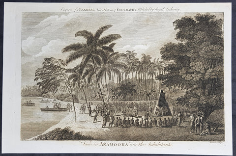
1787 Bankes Antique Print View of Nomuka Island, Tonga - Cooks Voyages in 1777
- Title : View in Anamooka and the Inhabitants
- Size: 14in x 9in (355mm x 230mm)
- Ref #: 21455
- Date : 1787
- Condition: (A+) Fine Condition
Description:
This fine original cooper-plate engraved antique print of a view of the Island of Nomuka, a small island in the southern part of the Ha apai islands, in the Kingdom of Tonga, during Captain Cooks 3rd Voyage of discovery to the South Seas in 1777 was published in Thomas Bankes 1787 edition of A New, Royal and Authentic System of Universal Geography, Antient and Modern..... printed by Charles Cook, London.
General Definitions:
Paper thickness and quality: - Heavy and stable
Paper color : - off white
Age of map color: -
Colors used: -
General color appearance: -
Paper size: - 14in x 9in (355mm x 230mm)
Plate size: - 12in x 7 1/2in (305mm x 190mm)
Margins: - Min 1/2in (12mm)
Imperfections:
Margins: - None
Plate area: - None
Verso: - None
Background:
Nomuka is a small island in the southern part of the Ha apai group of islands in the Kingdom of Tonga. It is part of the Nomuka Group of islands, also called the Otu Muomua.
Nomuka, is 7 square kilometres in area and contains a large, brackish lake (Ano Lahi) in the middle, and also three other smaller lakes—Ano Haamea, Ano Fungalei, and Molou. There are approximately 400-500 inhabitants who subsist on fishing, farming, and remittances from family members abroad. The island has a secondary school, two primary schools, and a kindergarten. It also has seven churches.
The island is accessible by boat only. Boats leave weekly from Nukualofa and Lifuka, Haapai. There is one guesthouse on the island, and three or four small fale koloa, or convenience stores.
Notable historic visitors include Abel Tasman, Captain Cook, Captain Bligh, and William Mariner. The Dutch Abel Tasman made the first European discovery of the island on 24 January 1643. A party went ashore to get water, and the description of the huge lake they brought back afterwards leaves little doubt about the identification. Tasman called it Rotterdam island, after the city of Rotterdam, a major port in the Netherlands, and noted in his maps the indigenous name of Amamocka, a misspelling of ʻa Nomuka, ʻa being a subject indicating article. We also find the name of Amorkakij for Nomuka iki. Captain Bligh in the Bounty spent 3 days wooding and watering at Nomuka in April 1789. The Mutiny on the Bounty occurred the day after they left.
Cooks Diary.........as it was, Cook did not encounter the Tongan islands until his Second Voyage, when he stopped at both \'Eua and Tongatapu (or, by Tasman\'s nomenclature, Middleburg and Amsterdam respectively) in October of 1773. Here he was \"welcomed a shore by acclamations from an immence [sic] crowd of Men and Women not one of which had so much as a stick in their hands\".
Indeed, Cook found the islanders to be so accommodating that he returned to the archipelago in 1774 on his way back from New Zealand. Stopping at the island of Nomuka, Cook was sought out by name, and with this \"proof that these people have a communication with Amsterdam \", the cultural unity of the islands was established.
It was at this time that he famously named the island group the Friendly Archipelago, \"as a lasting friendship seems to subsist among the Inhabitants and their Courtesy to Strangers intitles [sic] them to that Name.\"
Cook\'s Third Voyage also included a visit to Tonga, this time for a stay of several months. Cook first dropped anchor at Nomuka in May, and then, at the invitation of the great chief Finau, travelled to another island, Lifuka. Here, Cook and his men were treated to such entertainments as \"whould [sic] have met with universal applause on a European Theatre.
Cook\'s Third Voyage (1776-1779)
In the course of his first two voyages, Cook circumnavigated the globe twice, sailed extensively into the Antarctic, and charted coastlines from Newfoundland to New Zealand. Following these achievements, Cook\'s third voyage was organized to seek an efficient route from England to southern and eastern Asia that would not entail rounding the Cape of Good Hope. The search for such a Northwest (or Northeast) Passage had been on the agenda of northern European mariners and merchants since the beginning of European expansion in the late fifteenth century. England\'s growing economic and colonial interests in India in the later eighteenth century provided the stimulus for the latest exploration for this route.
Cook, again in command of the Resolution, was to approach the Northwest Passage from the Pacific accompanied by a second ship, the Discovery, captained by Charles Clerke. The ships left England separately, regrouped at Cape Town, and continued on to Tasmania, New Zealand, and Tahiti. The expedition then sailed north and made landfall at Christmas Island and the Hawaiian Islands. Cook continued northward and charted the west coast of North America from Northern California as far as the Bering Strait. He returned to Hawaii for the winter and was killed in a skirmish with natives on February 14, 1779. Upon Cook\'s death, Clerke took command of the expedition but died six months later. The ships returned to England in 1780 under John Gore, who had commanded the Discovery after Cook\'s death. From start to finish, the voyage had lasted more than four years. (Ref Tooley; M&B; Clancy)