On Sale (230)
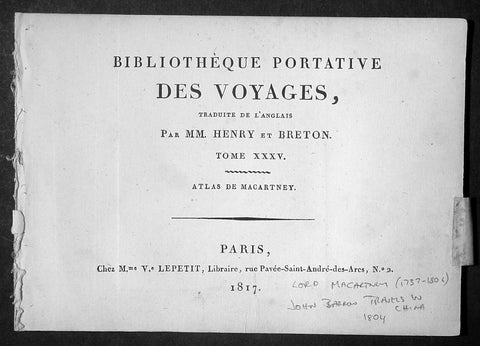
1817 Lord Macartney Antique Atlas of Travels in China in 1794 - 22 Illustrations
- Title: Bibliotheque Portative Des Voyages Traduite De L Anglais Par MM. Henry et Breton Tome XXV - 1817
- Date: 1817
- Condition: (A+) Fine Condition
- Ref : MACTP
- Size: 8vo
Description:
This fine original antique French edition Atlas of the travels of Ambassador Lord Macartney travels in China between 1792 & 1794 was translated and published in Paris by M Henry & Breton in the 1817 - dated - edition of Biblio Portative Des Voyages Traduite De L Anglais Par MM. Henry et Breton Tome XXXV (Portable Travel Library. Translated from the English by MM Henry and Breton Volume 35)
General Description:
Paper thickness and quality: - Heavy and stable
Paper color: - off white
Age of map color: -
Colors used: -
General color appearance: -
Page size: - 7in x 5in (180mm x 125mm)
Imperfections:
Margins: - Light age toning
Plate area: - None
Verso: - None
The atlas covers have been removed with front title page Pages are generally clean with light aging to borders, overall VG, 8vo, each page size is 7in x 5in (180mm x 125mm)
This atlas contains 22 B&W copper-plate engraved prints, listed below.
1. Lord Macartney
2. Arbe a pain de Singe (Monkey Tree)
3. Feuille de Nopal avec Cochenille qui s y Nourit
4. Barque Cochinchinoise (Chinese Barge)
5. Mandarin de Curon
6. Insects qui produisent la Cire de la Cochinchine (Insects that produce the wax of the Cochin China)
7. Maniere de lever les Filets (Net fishing)
8. Pieds des Dames Chinoisec (feet of Chinese Ladies)
9. Chaise a Porteurs (Chair Porters)
10. Maniere de transporter les Fardeaux (Carrying freight)
12. Vue de la Grande Muraille de la Chinese (Great Wall of China)
13. Portrait de l Empereur Cohien Long
14. Bourse et Sceptre de L Empereur (Money & Sceptre of Emperor)
15. Fondateur de l Empire Chinois (Founder of Chinese Empire)
16. Maniere de elever L Eau (Water irrigation)
17. Charrue Chinoise (Plough)
18. Pecheurs portant leur canot et les Oiseaux avec les quels ils prennent le poisson (Using ducks to catch fish)
19. Maniere de degager le Riz de sa pellicule (Rice farming)
20. Cha-wha ou Camellia sesanqua (Camilla flower)
21. Pompe a Chaine (Irrigation)
22. Grotte du Camoens...
Sir George, Earl Macartney, was born at Lissanoure, in the northern part of the County of Antrim, 14th May 1737. Having passed through Trinity College, he entered the Middle Temple, made an extended tour of Europe (becoming acquainted with Rousseau and other persons of eminence), and shortly after his return home in 1764, was, through an intimacy with Lord Holland, appointed a special envoy to negotiate a commercial treaty with Russia. His biographer says: "His knowledge of European politics alone fitted him for the undertaking; but a graceful person, with great suavity of manners, a conciliating disposition, and winning address, were considered as no slight recommendations at a female court, where such accomplishments, it was fair to conclude, might work their way, when great and unaccommodating talents alone would prove ineffectual."
From September 1792 to September 1794, he spent abroad as ambassador to China. The country was then little known, and Lord Macartney's published account of his embassy long continued the standard book of information on Chinese matters. Commenting on his mission, a writer says: "The amount of the benefit gained by this first diplomatic communication on the part of England with the Court of Pekin has been matter of dispute; but it is generally agreed that no other person could have accomplished more than was done by Lord MaCartney, whose conduct at least was well calculated to impress the subjects of the Celestial Empire with a respect for the country which he represented."[97] In 1795 he was sent on a confidential mission to Italy; and from November 1796 to November 1798 he was Governor of the Cape of Good Hope, then newly captured from the Dutch. "There is no praise," says Lord Melville, "to which he is not entitled on the score of his government of the Cape." All his nerve and tact were called forth in 1797 by an attempted mutiny of the British fleet in Simon's Bay, following the news of the mutiny at the Nore.
Impaired health obliged him to give up this, his last official post, and return home. The Union gave him unbounded satisfaction: writing during the negotiations, he said: "I bow with admiration and respect to those by whose wisdom this great and important object has been brought so near to its completion. Considering many things that have happened in my time, painful to recollect and invidious to mention, I little imagined to see this happy day. Thank God! I have seen it. I thank the Father of all mercies that he has been graciously pleased to prolong my days to this auspicious period. The measure before us has my dying voice. It will annihilate the vain hopes of a vain insidious foe from without, and, I trust, will contribute to defeat the projects of a dark and treacherous enemy within." His last years were passed in retirement at Chiswick; his enjoyment of the society of a large circle of eminent men being lessened by severe sufferings from gout. He died, childless, 31st March 1806, aged 68, and was buried at Chiswick. In 1792 he had been created a Viscount; in 1794 an Earl; and in 1796 a British peer. His features were regular and well proportioned, his countenance open, placid, and agreeable. He possessed all the dignity of the " old school," without its stiffness, and retained it in his dress, which he did not materially alter for the last forty years of his life. (Ref Clancy; Tooley; M&B)
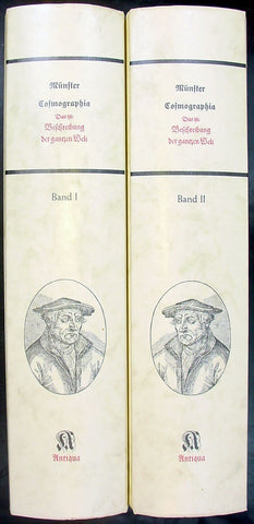
Sebastian Munster Reproduction 2 vol of Cosmographia
- Title: Munster Cosmographia
- Date: 1988
- Condition : (A+) Fine Condition
- Ref: Cosmo1
- Size: Folio
Description:
Two volume 1988 reprint of the 1628 edition of Sebastian Munster's Cosmographia Basel, Beyden Henripetrinischen. Until 1578, the editions of the Cosmographia were published by Munster's stepson, Heinrich Petri (1508 - 1579). Thereafter they were published by the latters son, Sebastian Petri.
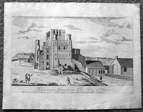
1718 Slezer Antique Print View of Kelso Abby & Township, Scotland
- Title : The Abby of Kelso
- Date : 1718
- Ref # : 24953
- Size : 18 ½in x 14 ½in (470mm x 360mm)
- Condition: (A+) Fine
Description:
This fine beautifully hand coloured original antique print a view of Kelso Abby & Kelso Town, Scotland was published in the 1718 edition of John Slezer's 'Theatrum Scotiae'.
Kelso Abbey is a ruined Scottish abbey in Kelso, Scotland. It was founded in the 12th century by a community of Tironensian monks first brought to Scotland in the reign of Alexander I. It occupies ground overlooking the confluence of the Tweed and Teviot waters, the site of what was once the Royal Burgh of Roxburgh and the intended southern centre for the developing Scottish kingdom at that time. Kelso thus became the seat of a pre-eminently powerful abbacy in the heart of the Scottish Borders.
In the 14th century, Roxburgh became a focus for periodic attack and occupation by English forces and Kelso's monastic community survived a number of fluctuations in control over the area, restoring the abbey infrastructure after episodes of destruction and ultimately retaining Scottish identity. From 1460 onwards, life for the abbey probably grew more settled, but came once again under attack in the early sixteenth century. By the mid-century, through a turbulent combination of events, the abbey effectively ceased to function and the building fell into ruin.
Although the site of Kelso Abbey has not been fully excavated in modern times, evidence suggests that it was a major building with two crossings. The only remains standing today are the west tower crossing and part of the infirmary. The massive design and solid romanesque style of the tower indicate a very large building of formidable, semi-military construction and appearance, evidence of the importance with which Roxburgh was regarded when the abbacy was at the height of its power.
This is an important and rare print as Slezer s Theatrum Scotiae is one of the earliest records of early Scottish towns & major buildings. (Ref: Tooley; M&B)
General Description:
Paper thickness and quality: - Heavy and stable
Paper color: - off white
Age of map color: -
Colors used: -
General color appearance: -
Paper size: - 18 ½in x 14 ½in (470mm x 360mm)
Plate size: - 16 ½in x 11in (420mm x 275mm)
Margins: - Min 1in (25mm)
Imperfections: Margins: - Light age toning
Plate area: - Light age toning
Verso: - Light age toning
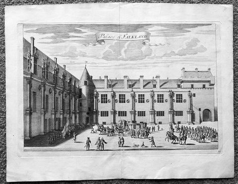
1718 Slezer Antique Print View of Falkland Palace, Fife, Scotland
- Title : Palace of Falkland
- Date : 1718
- Ref # : 24958
- Size : 18 ½in x 14 ½in (470mm x 360mm)
- Condition: (A+) Fine
Description:
This fine beautifully hand coloured original antique print a view of the internal courtyard of Falkland Palace, home of the Scottish Kings - was published in the 1718 edition of John Slezer's 'Theatrum Scotiae'.
Falkland Palace in Falkland, Fife, Scotland, is a former royal palace of the Scottish Kings. The Scottish Crown acquired Falkland Castle from MacDuff of Fife in the 14th century. In 1402 Robert Stewart, 1st Duke of Albany imprisoned his nephew David Stewart, Duke of Rothesay, the eldest son of King Robert III of Scotland, at Falkland. The incarcerated Duke eventually died there from neglect and starvation. Albany was exonerated from blame by Parliament, but suspicions of foul play persisted, suspicions which never left Rothesay's younger brother the future James I of Scotland, and which would eventually lead to the downfall of the Albany Stewarts. John Debrett, writing in 1805, was in no doubt of Duke Robert's motives and guilt. This Robert, Duke of Albany, having obtained the entire government from his brother, King Robert, he caused the Duke of Rothesay to be murdered, thinking to bring the Crown into his own family; but to avoid the like fate, King Robert resolved to send his younger son James, to France, then about nine years old, who being sea-sick, and forced to land on the English coast ... was detained a captive in England eighteen years. At these misfortunes King Robert died of grief in 1406. Between 1501 and 1541 Kings James IV and James V of Scotland transformed the old castle into a beautiful royal palace: with Stirling Castle it was one of only two Renaissance palaces in Scotland. To address the poor state of the garden and park, James V appointed a new Captain and Keeper, William Barclay, Master of Rhynd, in March 1527. Ten years later, James V extended his father's buildings in French renaissance style. He died at Falkland in December 1542 after hearing that his wife had given birth to a daughter—Mary, Queen of Scots. Falkland became a popular retreat with all the Stewart monarchs. They practised falconry there and used the vast surrounding forests for hawking and for hunting deer. Wild boar, imported from France, were kept in the Park, within a fence made by the Laird of Fernie. Nearby Myres Castle is the hereditary home of the Royal Macers and Sergeants at Arms who served Falkland Castle since at least the sixteenth century. John Scrimgeour of Myres supervised building at the Palace from 1532 to 1563. After the Union of the Crowns (1606), James VI and I, Charles I, and Charles II all visited Falkland. A fire partially destroyed the palace during its occupation by Cromwell's troops and it quickly fell into ruin.
This is an important and rare print as Slezer s Theatrum Scotiae is one of the earliest records of early Scottish towns & major buildings. (Ref: Tooley; M&B)
General Description:
Paper thickness and quality: - Heavy and stable
Paper color: - off white
Age of map color: -
Colors used: -
General color appearance: -
Paper size: - 18 ½in x 14 ½in (470mm x 360mm)
Plate size: - 16 ½in x 11in (420mm x 275mm)
Margins: - Min 1in (25mm)
Imperfections: Margins: - None
Plate area: - None
Verso: - None
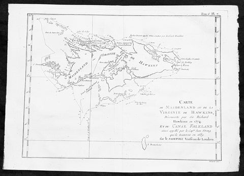
1747 Bellin Antique Map of the Falkland or Maldives Islands Argentina South America
- Title: Carte de Maidenland ou de la Virginie de Hawkins...Richard Hawkins 1574...Cap Jean Strong...1689
- Date: 1747
- Condition : (A+) Fine Condition
- Ref: 35488
- Size: 14in x 10in (360mm x 255mm)
Description:
This fine, original copper-plate engraved antique map of the Falkland Islands by Jacques Nicolas Bellin in 1750 was published in Antoine François Prevosts 15 volumes of Histoire Generale des Voyages written by Prevost & other authors between 1746-1790.
Although Fuegians from Patagonia may have visited the Falkland Islands in prehistoric times, the islands were uninhabited at the time of their discovery by Europeans. Claims of discovery date back to the 16th century, but no consensus exists on whether early explorers discovered the Falklands or other islands in the South Atlantic. The first recorded landing on the islands is attributed to English captain John Strong, who, en route to Peru\'s and Chile\'s littoral in 1690, discovered the Falkland Sound and noted the islands\' water and game.
The Falklands remained uninhabited until the 1764 establishment of Port Louis on East Falkland by French captain Louis Antoine de Bougainville, and the 1766 foundation of Port Egmont on Saunders Island by British captain John MacBride. Whether or not the settlements were aware of each other\'s existence is debated by historians. In 1766, France surrendered its claim on the Falklands to Spain, which renamed the French colony Puerto Soledad the following year. Problems began when Spain discovered and captured Port Egmont in 1770. War was narrowly avoided by its restitution to Britain in 1771.
Both the British and Spanish settlements coexisted in the archipelago until 1774, when Britain\'s new economic and strategic considerations led it to voluntarily withdraw from the islands, leaving a plaque claiming the Falklands for King George III. Spain\'s Viceroyalty of the Río de la Plata became the only governmental presence in the territory. West Falkland was left abandoned, and Puerto Soledad became mostly a prison camp.Amid the British invasions of the Río de la Plata during the Napoleonic Wars in Europe, the islands\' governor evacuated the archipelago in 1806; Spain\'s remaining colonial garrison followed suit in 1811, except for gauchos and fishermen who remained voluntarily.
General Definitions:
Paper thickness and quality: - Heavy and stable
Paper color : - off white
Age of map color: -
Colors used: -
General color appearance: -
Paper size: - 14in x 10in (355mm x 255mm)
Plate size: - 12in x 8in (305mm x 205mm)
Margins: - Min 1/2in (12mm)
Imperfections:
Margins: - None
Plate area: - None
Verso: - None
Background:
One of Antoine Francois Prevosts monumental undertakings was his history of exploration & discovery in 15 volumes titledHistoire Générale des Voyages written between 1746-1759 and was extended to 20 volumes after his death by various authors.
The 20 volumes cover the early explorations & discoveries on 3 continents: Africa (v. 1-5), Asia (v. 5-11), and America (v. 12-15) with material on the finding of the French, English, Dutch, and Portugese.
A number of notable cartographers and engravers contributed to the copper plate maps and views to the 20 volumes including Nicolas Bellin, Jan Schley, Chedel, Franc Aveline, Fessard, and many others.
The African volumes cover primarily coastal countries of West, Southern, and Eastern Africa, plus the Congo, Madagascar, Arabia and the Persian Gulf areas.
The Asian volumes cover China, Korea, Tibet, Japan, Philippines, and countries bordering the Indian Ocean.
Volume 11 includes Australia and Antarctica.
Volumes 12-15 cover voyages and discoveries in America, including the East Indies, South, Central and North America.
Volumes 16-20 include supplement volumes & tables along with continuation of voyages and discoveries in Russia, Northern Europe, America, Asia & Australia.
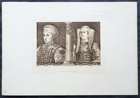
1870 Amand-Durand after Baccio Baldini Antique Print Ludovico Gonzaga III & Wife
- Title : Ludovico Gonzaga III and his Wife
- Date : 1870
- Condition: (A+) Fine Condition
- Ref: 22042
- Size: 13 1/2in x 9 1/2in (345mm x 240mm)
Description:
This fine, original antique Heliograph of Ludovico Gonzaga III and his Wife, Barbara of Brandenburg, by the Italian engraver Andrea Mantegna in the 15th century was re-engraved and published by Charles Amand-Durand in 1870.
These faithful re-engravings of classic and historical wood-cuts were faithfully re-issued by Amand-Durand in Paris in the mid to late 19th century. Such is the quality of his re-strikes that Durands prints are now in major institutional collections such a the Louvre, National Gallery, The Met and many other famous Galleries. Please see below for further background on Amand-Durand.
General Definitions:
Paper thickness and quality: - Heavy and stable
Paper color : - off white
Age of map color: -
Colors used: -
General color appearance: -
Paper size: - 13 1/2in x 9 1/2in (345mm x 240mm)
Plate size: - 8in x 6in (205mm x 1530mm)
Margins: - Min 1in (25mm)
Imperfections:
Margins: - None
Plate area: - None
Verso: - None
Background:
Andrea Mantegna 1431 – 1506 was an Italian painter, a student of Roman archeology, and son-in-law of Jacopo Bellini. Like other artists of the time, Mantegna experimented with perspective, e.g. by lowering the horizon in order to create a sense of greater monumentality. His flinty, metallic landscapes and somewhat stony figures give evidence of a fundamentally sculptural approach to painting. He also led a workshop that was the leading producer of prints in Venice before 1500.
Mantegna was no less eminent as an engraver, though his history in that respect is somewhat obscure, partly because he never signed or dated any of his plates, but for a single disputed instance of 1472. The account which has come down to us from Vasari (as usual keen to assert that everything flows from Florence) is that Mantegna began engraving in Rome, prompted by the engravings produced by the Florentine Baccio Baldini after Sandro Botticelli. This is now considered most unlikely as it would consign all the numerous and elaborate engravings made by Mantegna to the last sixteen or seventeen years of his life, which seems a scanty space for them, and besides the earlier engravings indicate an earlier period of his artistic style. He may have begun engraving while still in Padua, under the tuition of a distinguished goldsmith, Niccolò. He and his workshop engraved about thirty plates, according to the usual reckoning; large, full of figures, and highly studied. It is now considered either that he only engraved seven himself, or none. Another artist from the workshop who made several plates is usually identified as Giovanni Antonio da Brescia (aka Zoan Andrea).
Among the principal examples are: Battle of the Sea Monsters, Virgin and Child, a Bacchanal Festival, Hercules and Antaeus, Marine Gods, Judith with the Head of Holophernes, the Deposition from the Cross, the Entombment, the Resurrection, the Man of Sorrows, the Virgin in a Grotto, and several scenes from the Triumph of Julius Caesar after his paintings. Several of his engravings are supposed to be executed on some metal less hard than copper. The technique of himself and his followers is characterized by the strongly marked forms of the design, and by the parallel hatch marks to produce shadows. The closer the parallel marks, the darker the blacks were. The prints are frequently to be found in two states, or editions. In the first state the prints have been taken off with the roller, or even by handpressing, and they are weak in tint; in the second state the printing press has been used, and the ink is stronger.
Neither Mantegna or his workshop are now believed to have produced the so-called Mantegna Tarocchi cards.
Ludovico III Gonzaga of Mantua, also spelled Lodovico 1412 – 1478 was the ruler of the Italian city of Mantua from 1444 to his death in 1478.
Ludovico was the son of Gianfrancesco I Gonzaga and Paola Malatesta.
Ludovico followed the path of his father, Gianfrancesco, fighting as a condottiero from as early as 1432, when Gianfrancesco was vice-commander of Francesco Bussone\'s army. In 1433, he married Barbara of Brandenburg, niece of emperor Sigismund.
Starting from 1436 (perhaps without the approval of his father) he entered the service of the Visconti of the Duchy of Milan. The result was that Gianfrancesco exiled Ludovico from Mantua, together with his wife, naming Carlo Gonzaga as heir. However, in 1438 Gianfrancesco himself was hired by the Visconti, and reconciled with Ludovico in 1441. Ludovico succeeded to the marquisate of Mantua in 1444, although part of the family fiefs went to his brothers Carlo, Gianlucido and Alessandro. At the time, the Mantuan state was reduced in size and in poor conditions after years of war and large expenses.
From 1445 to 1450 Ludovico served as condottiero for Milan, Florence, Venice and Naples, switching his allegiance in order to grant the higher level of peace for his lands. In 1448 he took part in the battle of Caravaggio, and was forced to flee. In 1449 he entered the service of Venice in the league formed with Florence against Milan. In 1450 he received permission to lead an army for King Alfonso of Naples in Lombardy, with the intent of gaining some possessions for himself. However, Francesco Sforza, the new duke of Milan, enticed him with the promise of Lonato, Peschiera and Asola, formerly Mantuan territories but then part of Venice. Venice responded by sacking Castiglione delle Stiviere (1452) and hiring Ludovico\'s brother, Carlo.
On 14 June 1453 Ludovico routed the troops of Carlo at Goito, but Venetian troops under Niccolò Piccinino thwarted any attempt to regain Asola. The Peace of Lodi (1454) obliged Ludovico to give back all his conquests, and to renounce definitively his claim to the three cities. However, he obtained his brother\'s land after Carlos childless death in 1456.
The moment of highest prestige for Mantua was the Council, held in the city from 27 May 1459 to 19 January 1460, summoned by Pope Pius II to launch a crusade against the Ottoman Turks, who had conquered Constantinople some years earlier. However, the pope was not satisfied with the host city, writing: The place was marshy and unhealthy, and the heat burnt up everything; the wine was unpalatable and the food unpleasant. However, the council ended on a note of great personal prestige for Ludovico with the elevation of his son Francesco to the purple.
From 1466 Ludovico was more or less constantly at the service of the Sforza of Milan. He died in Goito in 1478, during a plague. He was buried in Mantua cathedral
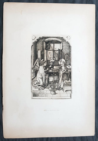
1870 Amand-Durand after Van Leyden Antique Print The Annunciation to Virgin Mary
- Title : Heliogravure et imp A. Durand...Paris
- Date : 1870
- Condition: (A+) Fine Condition
- Ref: 22445
- Size: 14in x 9 1/2in (350mm x 240mm)
Description:
This fine, original antique Heliograph of The Annunciation, the Virgin Mary visited by the Angel Gabriel by Lucas Van Leyden (1494 - 1533) in 1508 was re-engraved and published by Charles Amand-Durand in 1870.
These faithful re-engravings of classic and historical wood-cuts were faithfully re-issued by Amand-Durand in Paris in the mid to late 19th century. Such is the quality of his re-strikes that Durands prints are now in major institutional collections such a the Louvre, National Gallery, The Met and many other famous Galleries. Please see below for further background on Amand-Durand.
General Definitions:
Paper thickness and quality: - Heavy and stable
Paper color : - off white
Age of map color: -
Colors used: -
General color appearance: -
Paper size: - 13 1/2in x 9 1/2in (345mm x 240mm)
Plate size: - 8in x 6in (205mm x 1530mm)
Margins: - Min 1in (25mm)
Imperfections:
Margins: - None
Plate area: - None
Verso: - None
Lucas van Leyden (1494 – 1533), also named either Lucas Hugensz or Lucas Jacobsz, was a Dutch engraver and painter. He was among the first Dutch exponents of genre painting and is generally regarded as a very accomplished engraver.
Lucas was the son of Huygh Jacobsz. and was mainly active in Leiden.
Carel van Mander characterizes Lucas as a tireless artist, who as a child annoyed his mother by working long hours after nightfall, which she forbid not only for the cost of candlelight, but also because she felt that too much study was bad for his sensibilities. According to Van Mander, as a boy he only consorted with other young artists, such as painters, glass-etchers and goldsmiths, and was paid by the Heer van Lochorst (Johan van Lockhorst of Leiden, who died in 1510) a golden florin for each of his years at age 12 for a watercolor of St. Hubert.
From 1513 to 1517, Lucas created a series of woodcuts called The Power of Women which consisted of two large and small sets of prints. The series is one of a number of representations of the Power of Women theme, which was extremely popular in Renaissance art and literature. Artworks in the genre depict the traditional roles of men and women in inverse, with women dominating over men in various situations. The subjects illustrated often consist of legendary historical women who were considered to be virtuous heroines as well as women who were considered cunning, seductive, and manipulative of men. The purpose of the Power of Women theme was to demonstrate that even the strongest and wisest of men were not resistant to the sexuality of women.
The Annunciation (from Latin annuntiatio), also referred to as The Annunciation to the Blessed Virgin Mary, the Annunciation of Our Lady, or the Annunciation of the Lord, is the Christian celebration of the announcement by the angel Gabriel to the Virgin Mary that she would conceive and become the mother of Jesus, the Son of God, marking his Incarnation. Gabriel told Mary to name her son Yeshua, meaning YHWH is salvation.
According to Luke 1:26, the Annunciation occurred in the sixth month of Elizabeth\'s pregnancy with John the Baptist. Many Christians observe this event with the Feast of the Annunciation on 25 March, an approximation of the northern vernal equinox nine full months before Christmas, the ceremonial birthday of Jesus. The Annunciation is a key topic in Christian art in general, as well as in Marian art in the Catholic Church, particularly during the Middle Ages and Renaissance. A work of art depicting the Annunciation is sometimes itself called an Annunciation.
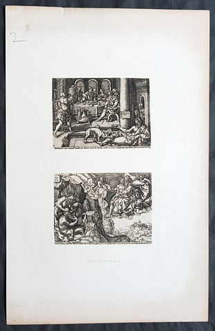
1870 Amand-Durand after Heinrich Aldegrever Antique Print - Parable of Lararus
- Title : Erumnos hic lazar iages ad ianva divitis/Dives epvlo elamis
- Date : 1870
- Condition: (A+) Fine Condition
- Ref: 22444
- Size: 13 1/2in x 9 1/2in (345mm x 240mm)
Description:
This fine, original antique Heliograph two panels of the parable of The Rich Man and Lazarus or Dives and Lazarus or Lazarus and Dives by the German engraver Heinrich Aldegrever or Aldegraf in the early 16th century was re-engraved and published by Charles Amand-Durand in 1870.
These faithful re-engravings of classic and historical wood-cuts were faithfully re-issued by Amand-Durand in Paris in the mid to late 19th century. Such is the quality of his re-strikes that Durands prints are now in major institutional collections such a the Louvre, National Gallery, The Met and many other famous Galleries. Please see below for further background on Amand-Durand.
General Definitions:
Paper thickness and quality: - Heavy and stable
Paper color : - off white
Age of map color: -
Colors used: -
General color appearance: -
Paper size: - 13 1/2in x 9 1/2in (345mm x 240mm)
Plate size: - 8in x 6in (205mm x 1530mm)
Margins: - Min 1in (25mm)
Imperfections:
Margins: - None
Plate area: - None
Verso: - None
Background:
Heinrich Aldegrever or Aldegraf (1502–1561) was a German painter and engraver. He was one of the Little Masters, the group of German artists making small old master prints in the generation after Dürer.
Painter, printmaker and goldsmith active in a Westphalia milieu. Born in Paderborn. His real name was Trippenmecker, which in Westphalian dialect means a clog-maker. It is not known where Aldegrever was taught. He probably worked in a workshop of one of the Soest goldsmiths. His early works show a strong Westphalian influence. Aldegrever made a journey to the Netherlands, where he became acquainted with works of Joos van Cleve, Barendt van Orley, Lucas van Leyden and Jacob Cornelisz.
Around 1525 he moved to Soest, where a year later he painted the wings and predella of the Mary altar for the church of St. Peter. His signature and symbolic clog show that he was still using his fathers name.
His first engravings appeared in 1527. They were signed with a monogram AG, resembling closely that of Albrecht Dürer. In 1531, influenced by surrounding religious fervour, he became a Lutheran. Because of lack of church commissions he devoted most of his time to portrait painting and printmaking. Aldegrevers some 290 engravings and woodcuts, chiefly from his own designs, are delicate and minute, though somewhat hard in style, and entitle him to a place in the front rank of the so-called Little Masters: Barthel Beham, his brother Hans Sebald Beham, and Georg Pencz, with whom he is often compared. Like them, he was also a skilled ornament designer. From the close resemblance of his style to that of Albrecht Dürer he has also sometimes been called the Albert of Westphalia.
About a third of his prints were ornamental engravings; they were used as models by artists and craftsmen well into the seventeenth century.
Aldegrever, who actively supported the Reformation, executed portraits of Martin Luther and Philip Melanchthon. Although he chose the Lutheran Church, he had friends among the Anabaptists. He was commissioned by the bishop of Münster in 1535–36 to engrave portraits of Anabaptist leaders Jan van Leyden and Bernhard Knipperdolling, although they were already imprisoned, and only caricatures of them circulated. In the cycle Power of Death, done under visible influence of Hans Holbein, he criticizes the vices of the Catholic Church.
Aldegrever was interested also in folk subjects. In 1538 and 1551 two series of prints depicting marriage dances were made. An important part of his oeuvre are prints on mythological subjects, the Deeds of Hercules being one of the best examples.
Only two paintings are firmly attributed to him: the wings and predella of the Marienaltar (c. 1525-6) in the Wiesenkirche in Soest, and a portrait of Graf Phillip von Waldeck (1837) in Schloss Aroldsen
The parable of the rich man and Lazarus(also called the Dives and Lazarus or Lazarus and Dives) is a well-known parable of Jesus appearing in the Gospel of Luke.
The Gospel of Luke (Luke 16:19–31) tells of the relationship, during life and after death, between an unnamed rich man and a poor beggar named Lazarus. The traditional name Dives is not actually a name, but instead a word for rich man, dives in the text of the Latin Bible, the Vulgate. The rich man was also given the names Neuēs (i.e. Nineveh) and Fineas (i.e. Phineas) in the 3rd and 4th centuries.
Along with the parables of the Ten Virgins, Prodigal Son, and Good Samaritan, it was one of the most frequently illustrated parables in medieval art, perhaps because of its vivid account of an afterlife.
1698 De Bruyn Antique Print of Cacao, Chinese lemon, Jaka Plants of Indonesia
- Title : Kakauw vrugt, Chineesche Citroen, Jaka or Soorsacke, Blim-Bing boom and Nam-Nam boom
- Date : 1698
- Condition: (A+) Fine Condition
- Ref: 23405
- Size: 18 1/2in x 16in (470mm x 405mm)
Description:
This beautifully hand coloured original antique print of Cacao fruit, Chinese lemon, Jaka or Soorsacke, Nam-Nam tree and a Blim-bing tree from Indonesia was published as part of Cornelis de Bruyn`s (1652 c.1726) monumental travel publication Reizen Door Klien Asia, 1698.
De Bruyn was a Dutch portrait painter and traveler. He painted for some years in Italy, where he was known, in Rome, as Adonis. Bruyn is remembered chiefly for the records of his extensive travels in Egypt, Persia, India, and other countries, illustrated with his own designs. (Ref: M&B, Tooley)
General Description:
Paper thickness and quality: - Heavy & stable
Paper color: - White Age of map color: - Early
Colors used: - Blue, yellow, green, red
General color appearance: - Authentic
Paper size: - 18 1/2in x 16in (470mm x 405mm)
Plate size: - 11 1/2in x 11 1/2in (290mm x 290mm)
Margins: - Min 2in (50mm)
Imperfections:
Margins: - None
Plate area: - None
Verso: - None
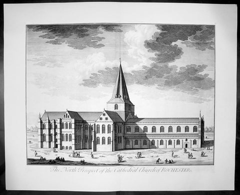
1724 Johannes Kip Large Antique Print of Rochester Cathedral, Kent, England
- Title : The North Prospect of the Cathedral Church of Rochester
- Date : 1724
- Condition: (A+) Fine Condition
- Ref: 40405
- Size: 26 1/2in x 22in (670mm x 560mm)
Description: This large original copper-plate engraved antique print by Johannes (Jan) Kip, after Leonard Knyff, was published in the 1724 Joseph Smith edition of Britannia Illustrata or Nouveau Theatre de la Grande Bretagne. This beautifully engraved original antique print is testimony to the fine, detailed work produced by Jan Kip.
Britannia Illustrata was first issued in 1707 by David Mortier as a single volume containing 80 topographical etchings by Johannes Kip, after drawings by Leonard Knyff. Many are birds eye views of country seats, but there are also a number of interesting London views. The series was first reissued and expanded into two volumes in 1708-1713, and provided with a second French title Nouveau Theatre de la Grande Bretagne.
An expanded edition of Britannia Illustrata was re-published by Joseph Smith in 1724 under its French title, Nouveau Theatre..., containing many of the plates from the original edition by Mortier and also containing may new plates of places, churches, cathedrals and architecture of the landed gentry.
Background:
Being the second oldest cathedral foundation in England, Rochester Cathedrals history goes back to AD604 when Augustine sent Bishop Justus to establish the house founded by King Ethelbert of Kent. Following several invasions by the Danes, the church was in a state of devastation by the time Bishop Gundulf was consecrated in 1077 but immediately he began a major building operation, and introduced a community of Benedictine monks in 1080.
The church suffered misfortune again in the mid 12th century with two serious fires, resulting in a further rebuilding programme. Since that time there has been continuous remodelling, refurbishments and restorations, mainly due to other historical events when the cathedral sustained damage. As a consequence of its very chequered history, Rochester Cathedral displays the varied building styles of each period, from the functional austerity of Gundulf's original structure, through the Romanesque, Gothic and Early English architectural periods, and continuing with renovation and restoration well into the 20th century following war damage.
The sturdy, squat Norman nave contrasts dramatically with the tall, narrow Gothic arches of the crossing. A superbly carved stone archway of the Decorated period (c1345), now enhanced with a solid oak door, leads to the chapter room and is a magnificent feat of craftsmanship. Quite unusually, the Lady Chapel is sited between the nave and the south transept as monastic outbuildings occupied the traditional location at the eastern end of the church when the chapel was added in the late 15th century. Beneath the quire transept is a beautifully preserved and vaulted crypt, with two bays surviving from the original Norman construction. There are also many fragments of medieval ceiling paintings to be found in this lower level sanctuary.
Though one of the smaller Norman cathedrals, Rochester was an important centre for pilgrimage during the 13th century, and even today attracts many visitors who are keen to learn more about its fascinating history. From a photographic perspective, a wonderful view of Rochester cathedral can be seen from the top of Rochester Castle, immediately opposite. We have visited both the Rochester Cathedral and Castle on many occasions, and still manage to uncover more information, or something interesting that we had previously overlooked. Earlier this year, we ventured for the first time into the cloister garth, discovering a substantial section of the ruined Chapter House. On the south side, the entrance arch to the monk's refectory survives and, looking behind it, the 13th century lavatorium and towel recess is still visible.
Johannes Kip was a draughtsman and engraver, who worked first in his native Amsterdam before moving to London at the end of the seventeenth century. He did portraits, views, and book illustrations. (Ref: Tooley; M&B)
General Description:
Paper thickness and quality: - Heavy and stable
Paper colour: - off white
Age of map colour: -
Colours used: -
General colour appearance: -
Paper size: - 26 1/2in x 22in (670mm x 560mm)
Plate size: - 23in x 18in (585mm x 460mm)
Margins: - min 1in (25mm)
Imperfections:
Margins: - None
Plate area: - None
Verso: - None
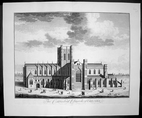
1724 Johannes Kip Large Antique Print of Chester Cathedral Church, Cheshire, England
- Title : The Cathedral Church of Chester
- Date : 1724
- Condition: (A+) Fine Condition
- Ref: 40412
- Size: 26 1/2in x 22in (670mm x 560mm)
Description: This large original copper-plate engraved antique print by Johannes (Jan) Kip, after Leonard Knyff, was published in the 1724 Joseph Smith edition of Britannia Illustrata or Nouveau Theatre de la Grande Bretagne. This beautifully engraved original antique print is testimony to the fine, detailed work produced by Jan Kip.
Britannia Illustrata was first issued in 1707 by David Mortier as a single volume containing 80 topographical etchings by Johannes Kip, after drawings by Leonard Knyff. Many are birds eye views of country seats, but there are also a number of interesting London views. The series was first reissued and expanded into two volumes in 1708-1713, and provided with a second French title Nouveau Theatre de la Grande Bretagne.
An expanded edition of Britannia Illustrata was re-published by Joseph Smith in 1724 under its French title, Nouveau Theatre..., containing many of the plates from the original edition by Mortier and also containing may new plates of places, churches, cathedrals and architecture of the landed gentry.
Background:
Standing on the site of a 10th century Saxon church, the present cathedral at Chester dates from the mid 13th century. Dedicated to St Werburgh, this Christian church was transformed into a Benedictine Abbey in 1092, colonised by a small group of monks from Normandy. Building of the new abbey church began immediately and took the best part of 150 years to complete but little evidence of the first church remains. The traditional sturdy Norman architecture was eventually replaced over the next two centuries by a more elegant Gothic style. Henry VIII dissolved the monastery in 1540 just as the monks of St Werburgh's Abbey were beginning to enjoy their new surroundings. A year later the abbey was given back as a cathedral, the last abbot of St Werburgh's becoming the first Dean of Chester Cathedral.
Over the next two hundred years the cathedral slipped into a bad state of disrepair but was eventually saved from total collapse by the efforts of Sir George Gilbert Scott. His 19th century restoration of Chester Cathedral, both externally and internally, not only put in place essential repairs but also enhanced the appearance of the great church immensely. Most of the stained glass comes from this period and highlights the abbey's dedication to St Werburgh, as well as the long history of the cathedral. On the northern aisle of the nave, at the side of one of the large windows, sits the 'Chester Imp'. A charming little figure in chains, carved by one of the medieval monks, to protect the church from evil spirits.
Most medieval cathedrals have beautifully carved stalls in the quire but the quality of oak carving at Chester Cathedral is quite exceptional. Each stall is topped with an elaborately carved canopy set above a row of small corbels, and below each seat a magnificently carved misericord. This area of the church is so richly carved with such a diverse array of religious artefacts, animals, birds and grotesque figures that it is quite overwhelming.
Apart from the main church many of the monastic buildings from the ancient Benedictine Abbey have been remarkably preserved. The original cloisters, although largely rebuilt during the first half of the 16th century and subsequently restored at the beginning of the 20th century, are a constant reminder of the important part they played in monastic life. All the bays of the undercroft, containing some wonderful vaulting, have been utilised to provide an exhibition centre, gift shop and workshop. The monks' dining room or refectory is still used regularly, as is the superb Chapter House. .
General Description:
Paper thickness and quality: - Heavy and stable
Paper colour: - off white
Age of map colour: -
Colours used: -
General colour appearance: -
Paper size: - 26 1/2in x 22in (670mm x 560mm)
Plate size: - 23in x 18in (585mm x 460mm)
Margins: - min 1in (25mm)
Imperfections:
Margins: - None
Plate area: - None
Verso: - None
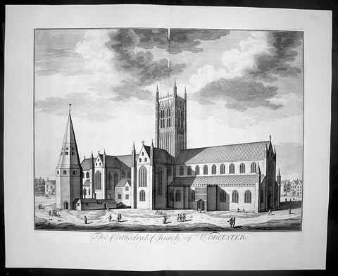
1724 Kip Large Folio Antique Print of Worcester Cathedral, England
- Title : The Cathedral Church of Worcester
- Date : 1724
- Condition: (A+) Fine Condition
- Ref: 40407
- Size: 26 1/2in x 22in (670mm x 560mm)
Description:
This finely engraved original large folio antique Cathedral print by Johannes Jan Kip, was engraved by James Collins was published in the 1724 by Joseph Smith monumental work Nouveau Theatre de la Grande Bretagne. This print also appeared in Britannia Illustrata by D. Mortier (brother of Pierre).
This is a finely engraved print being testimony to the beautiful and detailed work produced by Kip whose eye for detail was one of the most acknowledged of his day.
Background:
The history of Worcester goes back a long way. In 672, a council of the English Church was held, Worcester became the centre of five new dioceses formed. In the ninth century invasions from the Danes brought fighting to England, but Worcester being on the edge of the conflict escaped without much damage. In 983, Oswald founded a monastery at Worcester under the Benedictine rule, dedicated to St. Mary the Virgin. Wulfstan, in 1040 became a monk at Worcester and made such an impression, he became Bishop of Worcester in 1062. Wulfstan was the only Anglo-Saxon bishop to remain at his post after the Norman Conquest of 1066. In 1084, Wulfstan began rebuilding Worcester Cathedral, starting with the crypt, some of which still survives. He was canonised in 1203. Building work continued for some time, including rebuilding the two western bays of the nave in 1170 and around 1202 the central tower collapsed and there was a serious fire. In 1216, King John was buried at Worcester and he seems to have a devotion to St. Wulfstan. In 1224, Bishop William de Blois built the Lady Chapel, where he was buried when he died in 1236. In the fourteenth century the nave was completely rebuilt apart from the western bays. The central tower and the cloisters were completed built by 1374.
General Description:
Paper thickness and quality: - Heavy and stable
Paper colour: - off white
Age of map colour: -
Colours used: -
General colour appearance: -
Paper size: - 26 1/2in x 22in (670mm x 560mm)
Plate size: - 23in x 18in (585mm x 460mm)
Margins: - min 1in (25mm)
Imperfections:
Margins: - None
Plate area: - None
Verso: - None
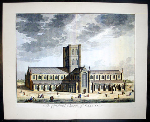
1724 Johannes Kip Large Antique Print a View of Carlisle Church in Cumbria, England
- Title : The Cathedral Church of Carlile
- Date : 1724
- Condition: (A+) Fine Condition
- Ref: 40406
- Size: 26 1/2in x 22in (670mm x 560mm)
Description: This large original copper-plate engraved antique print by Johannes (Jan) Kip, after Leonard Knyff, was published in the 1724 Joseph Smith edition of Britannia Illustrata or Nouveau Theatre de la Grande Bretagne. This beautifully engraved original antique print is testimony to the fine, detailed work produced by Jan Kip.
Britannia Illustrata was first issued in 1707 by David Mortier as a single volume containing 80 topographical etchings by Johannes Kip, after drawings by Leonard Knyff. Many are birds eye views of country seats, but there are also a number of interesting London views. The series was first reissued and expanded into two volumes in 1708-1713, and provided with a second French title Nouveau Theatre de la Grande Bretagne.
An expanded edition of Britannia Illustrata was re-published by Joseph Smith in 1724 under its French title, Nouveau Theatre..., containing many of the plates from the original edition by Mortier and also containing may new plates of places, churches, cathedrals and architecture of the landed gentry.
Background: Carlisle Cathedral bears the scars of 900 years spent in this most tumultuous of regions. The scarred exterior and tower, has the effect of making the cathedral look more like a Border castle than a church! The cathedral suffered badly in the Civil War, when Parliamentary troops under General Leslie almost destroyed the nave, leaving only two bays standing.
The original nave was built by secular canons in 1092 as a collegiate church. That early church was built, but by 1123 the Augustinian order had taken over. The choir aisles are late 13th century, but the body of the choir was not completed until a century later.
The transepts and tower date from the 15th century. The glories of Carlisle are the east window, one of the best examples of decorated tracery anywhere, and the delicately carved capitals in the choir, depicting the seasons. The east window is believed to be the work of Ivo de Ragheton, who was also responsible for the west front of York Minster.
The barrel-vaulted choir ceiling is painted in vivid blue with gold trim. Medieval paintings in the north and south aisles and the choir represent the lives of the Apostles and saints Anthony and Cuthbert. The choir stalls and misericords are decorated with wonderful carvings dating from the early 15th century.
This is a finely engraved print being testimony to the beautiful and detailed work produced by Kip whose eye for detail was one of the most acknowledged of his day.
Condition Report
Paper thickness and quality: - Heavy and stable
Paper colour: - off white
Age of map colour: - Early
Colours used: - Yellow, brown, green, red
General colour appearance: - Authentic
Paper size: - 24 1/2in x 19 1/2in (610mm x 495mm)
Plate size: - 23in x 18in (585mm x 470mm)
Margins: - min 1/4in (6mm)
Imperfections:
Margins: - None
Plate area: - None
Verso: - None
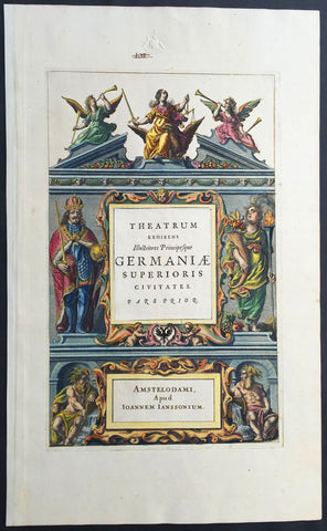
1640 Jansson Old, Antique German Atlas Title Page
- Title : Theatrum Exhibens Illustriores Principesque Germaniae
- Date : 1640
- Condition: (A+) Fine Condition
- Ref: 80014
- Size: 19 1/2in x 12in (495mm x 305mm)
Description:
This finely engraved beautifully hand coloured original antique Atlas Title Page was published by Jan Jansson for the in the 1640 edition of Jansson's German Atlas. (Ref Tooley M&B)
General Description:
Paper thickness and quality: - Heavy and stable
Paper color: - off white
Age of map color: - Original
Colors used: - Green, red, orange, yellow, blue
General color appearance: - Authentic
Paper size: - 19 1/2in x 12in (495mm x 305mm)
Plate size: - 14 1/2in x 9in (370mm x 230mm)
Margins: - Min 1in (25mm)
Imperfections:
Margins: - Blind stamp and old ink notation in top margin
Plate area: - None
Verso: - None

1817 Capt James Cook Antique Atlas of 1st Voyage to Australia - 22 Illustrations
- Title : Atlas Du Premier Voyage De Cook...Paris Chez M.me Lepetit....1817
- Date : 1817
- Condition: (A+) Fine Condition
- Ref: 91501
- Size: 8vo
Description:
This fine original antique Atlas of the 1st Voyage of Captain James Cooks Voyage of discovery to the South Seas was translated and published in Paris by M Henry & Breton in the 1817 - dated - edition of Biblio Portative Des Voyages Traduite De L Anglais Par MM. Henry et Breton Tome XVIII (Portable Travel Library. Translated from the English by MM Henry and Breton Volume 18)
General Description:
Paper thickness and quality: - Heavy and stable
Paper color: - off white
Age of map color: -
Colors used: -
General color appearance: -
Page size: - 7in x 5in (180mm x 125mm)
Imperfections:
Margins: - Light age toning
Plate area: - None
Verso: - None
This atlas contains 22 (of 23) copper-plate engraved prints, listed below.
The atlas covers have been removed with front title page partially detached. Pages are generally clean with light aging to borders, overall VG, 8vo, each page size is 7in x 5in (180mm x 125mm)
Cooks first voyage of discovery was his most important were he famously discovered and mapped the east coast of Australia and New Zealand. The prints in order are;
1. Patagonia
2. Dauphin in Tahiti
3. Captain Wallis in Tahiti
4. Indians in Terra Del Fuego
5. Bay of Matavia
6 & 21. Bread fruit & Maori War Instruments
7. View of Tahiti
8 & 9 Military dress of Tahiti
10 & 11 Military & everyday instruments from the south Seas
12. Way of burying the dead
13. N/A
14. View of Ulietea
15. House of Ulietea
16. View of Rocher Trove, NZ
17. Village on Rocher Trove, NZ
18 & 19. Jade Engraving & Maori warrior of New Zealand
20. War canoe of New Zealand
22. Endeavour River, Queensland
Cooks 1st Voyage:
The first voyage under Captain James Cook's command was primarily of a scientific nature. The expedition on the Endeavourinitially sailed to Tahiti to observe the transit of the planet Venus in order to calculate the earth's distance from the sun. Cook landed on the South Pacific island in April of 1769 and in June of that year the astronomical observations were successfully completed. In addition to these labors, very good relations with the Tahitians were maintained and the naturalists Joseph Banks and Daniel C. Solander conducted extensive ethnological and botanical research.
Another purpose of the voyage was to explore the South Seas to determine if an inhabitable continent existed in the mid-latitudes of the Southern Hemisphere. Upon leaving Tahiti, Cook named and charted the Society Islands and then continued southwest to New Zealand. His circumnavigation and exploration of that country also resulted in a detailed survey. Cook proceeded to Australia, where he charted the eastern coast for 2,000 miles, naming the area New South Wales. As a result of these surveys, both Australia and New Zealand were annexed by Great Britain. In addition to these explorations, the Endeavour returned to England without a single death from scurvy among its men, an historic feat at the time. The combination of these accomplishments brought Cook prominence, promotion, and the opportunity to lead further expeditions. (Ref Clancy; Tooley; M&B)
1817 John Barrow Original Antique Atlas of Travels in China in 1797 - 21 Prints
- Title : Bibliotheque Portative Des Voyages Traduite De L Anglais Par MM. Henry et Breton Tome XLII - Atlas De Barrow - Paris Chez M.Me V Lepetit....1817
- Date : 1817
- Condition: (A+) Fine Condition
- Ref: 91572
- Size: 8vo
Description:
This original antique Atlas of the travels of Sir John Barrow in China, who accompanied Ambassador Lord Macartney during his travelsin 1797, contains 21 coloured and B&W copper-plate engraved antique prints - was translated and published in Paris by M Henry & Breton in the 1817 - dated - edition of <i>Biblio Portative Des Voyages Traduite De L Anglais Par MM. Henry et Breton Tome XLII</i> (Portable Travel Library. Translated from the English by MM Henry and Breton Volume 42)
General Definitions:
Paper thickness and quality: - Heavy and stable
Paper color : - off white
Age of map color: - Original
Colors used: - Yellow, green, blue, pink
General color appearance: - Authentic
Paper size: - 7in x 5in (180mm x 125mm)
Plate size: - 7in x 5in (180mm x 125mm)
Margins: - Min 1/2in (12mm)
Imperfections:
Margins: - Light age toning
Plate area: - None
Verso: - None
The atlas covers have been removed with front title page - partially detached. The pages are generally clean with light aging to borders, overall VG, 8vo, each page size is 7in x 5in (180mm x 125mm)
This atlas contains 21 coloured & B&W copper-plate engraved prints, listed below.
1. Portrait de Van-ta-gin
2. Jonque pour les Voyages de long cours (Chinese Junks)
3. Chinois et Hottentot
4. Brouette a Voile (Wheelbarrow with sail)
5. Porte de Pakin
6. Palias de Yuen-min-Yuen
7. Parc oriental de Ge-hol
8. Jardins du Palais Imperial a Pekin
9. Caracteres Chinois & Medailles (Chinese Writing Characters & Money)
10. Artillerie, Mousquets &c. (Chinese Weapons)
11. Artillerie
13. Cloche de Pekin Gongs Cymbals &c.
14. Tcha ou Cangue, Exposition (Punishment of Prisoners)
15. Armes offensives & defensives (Chinese Weapons)
16. Ta ou Pagode (Chinese Pagoda)
17. Dame Chinoise avec son fils (Chinese Mother & Son)
18. Palais d un Mandarin
19. Village et Paysans (Village & Peasants)
20. Bateau passant sur un glacis (boats on a slipway)
21. Moulin a Riz (Rice thrasher)
Sir John Barrow (1764-1848),“Barrow'sTravels in China. an Investigation Into the Origin and Authenticity in "Travels in China, by J. Barrow" Preceded by a Inquiry Into the Nature of the "Powerful Motive" and Influence on His Duties at the Chinese Capital, in 1793”.
Barrow an English statesman, was born in the village of Dragley Beck in the parish of Ulverston in Lancashire, on the ,9th of June 1764. He started in life as superintending clerk of an iron foundry at Liverpool and afterwards taught mathematics at a school in Greenwich. Through the interest of Sir George Staunton, to whose son he taught mathematics, he was attached on the first British embassy to China as comptroller of the household to Lord Macartney. He soon acquired a good knowledge of the Chinese language, on which he subsequently contributed interesting articles to theQuarterly Review; and the account of the embassy published by Sir George Staunton records many of Barrow's valuable contributions to literature and science connected with China.
Although Barrow ceased to be officially connected with Chinese affairs after the return of the embassy in 1794, he always took much interest in them, and on critical occasions was frequently consulted by the British government. In 1797 he accompanied Lord Macartney, as private secretary, in his important and delicate mission to settle the government of the newly acquired colony of the Cape of Good Hope. Barrow was entrusted with the task of reconciling the Boers and Kaffirs and of reporting on the country in the interior. On his return from his journey, in the course of which he visited all parts of the colony, he was appointed auditor-general of public accounts. He now decided to settle in South Africa, married Anne Maria Triiter, and in 1800 bought a house in Cape Town. But the surrender of the colony at the peace of Amiens (1802) upset this plan. He returned to England in 1804, was appointed by Lord Melville second secretary to the admiralty, a post which he held for forty years. He enjoyed the esteem and confidence of all the eleven chief lords who successively presided at the admiralty board during that period, and more especially of King William IV. while lord high admiral, who honoured him with tokens of his personal regard. Barrow was a fellow of the Royal Society, and in 1821 received the degree of LL.D. from Edinburgh University. A baronetcy was conferred on him by Sir Robert Peel in 1835. He retired from public life in 1845 and devoted himself to writing a history of the modern Arctic voyages of discovery (1846), of which he was a great promoter, as well as his autobiography, published in 1847. He died suddenly on the 23rd of November 1848.
Besides the numerous articles in theQuarterly Review already mentioned, Barrow published among other works, Travels in China (1804); Travels into the Interior of South Africa (1806); and lives of Lord Macartney (1807), Lord Anson (1839), Lord Howe (1838). He was also the author of several valuable contributions to the seventh edition of the Encyclopaedia Britannica. Seememoir of John Barlow, by G. F. Staunton (1852). (Ref Clancy; Tooley; M&B)

1802 J B Lechevalier & Pierre Tardieu Large Antique Map of Corfu, Greece
- Title : Plan De L Ile De Corfou
- Date : 1802
- Condition: (A+) Fine Condition
- Ref: 70208
- Size: 21in x 14in (535mm x 355mm)
Description:
This original copper-plate engraved antique map of the Greek Island of Corfu was engraved by Pierre Tardieu and was published in the 1802 edition of Jean-Baptiste Lechevaliers of Voyage de la Troade, fait dans les années 1785 et 1786
General Definitions:
Paper thickness and quality: - Heavy and stable
Paper color : - off white
Age of map color: -
Colors used: -
General color appearance: -
Paper size: - 21in x 14in (535mm x 355mm)
Plate size: - 20 1/2in x 13in (520mm x 335mm)
Margins: - Min 1/2in (12mm)
Imperfections:
Margins: - Light soiling
Plate area: - Light soiling
Verso: - Light soiling
Background:
Corfu or Kerkyra is a Greek island in the Ionian Sea. It is the second largest of the Ionian Islands and, including its small satellite islands, forms the north-westernmost part of Greece. The island is part of the Corfu regional unit, and is administered as a single municipality, which also includes the smaller islands of Ereikoussa, Mathraki and Othonoi. The municipality has an area of 610,9 km2, the island proper 592,8 km2. The principal city of the island and seat of the municipality (pop. 32,095) is also named Corfu. Corfu is home to the Ionian University.
The island is bound up with the history of Greece from the beginnings of Greek mythology. Its history is full of battles and conquests. Ancient Korkyra took part in the Battle of Sybota which was a catalyst for the Peloponnesian War, and, according to Thucydides, the largest naval battle between Greek city states until that time. Thucydides also reports that Korkyra was one of the three great naval powers of fifth century BC Greece, along with Athens and Corinth. Medieval castles punctuating strategic locations across the island are a legacy of struggles in the Middle Ages against invasions by pirates and the Ottomans. Two of these castles enclose its capital, which is the only city in Greece to be surrounded in such a way. As a result, Corfu\'s capital has been officially declared a Kastropolis (castle city) by the Greek government. From medieval times and into the 17th century, the island, having successfully repulsed the Ottomans during several sieges, was recognised as a bulwark of the European States against the Ottoman Empire and became one of the most fortified places in Europe. The fortifications of the island were used by the Venetians to defend against Ottoman intrusion into the Adriatic. Corfu eventually fell under British rule following the Napoleonic Wars. Corfu was eventually ceded by the British Empire along with the remaining islands of the United States of the Ionian Islands, and unification with modern Greece was concluded in 1864 under the Treaty of London.
Jean-Baptiste Lechevalier was the secretary of the Ambassador of France in Constantinople. In the year 1788 he visited the plain of Troy, and was enthusiastically in favour of the theory that the site of Homers Troy was to be found at the village of Bunarbashi. His publication about Troy Voyage de la Troade.....was first published in 1799.
The Troad, also known as Troas, is the historical name of the Biga peninsula (Biga Yarımadası, Τρωάς) in the northwestern part of Anatolia, Turkey. This region now is part of the Çanakkale province of Turkey. Bounded by the Dardanelles to the northwest, by the Aegean Sea to the west and separated from the rest of Anatolia by the massif that forms Mount Ida, the Troad is drained by two main rivers, the Scamander (Karamenderes) and the Simois, which join at the area containing the ruins of Troy. Grenikos, Kebren, Simoeis, Rhesos, Rhodios, Heptaporos and Aisepos were seven rivers of the Troad and the names of the river gods that inhabited each river.
Troy (Ancient Greek: Τροία, Troia or Τροίας, Troias, Truva or Troya) was a city in the far northwest of the region known in late Classical antiquity as Asia Minor, now known as Anatolia in modern Turkey, just south of the southwest mouth of the Dardanelles strait and northwest of Mount Ida. The present-day location is known as Hisarlik. It was the setting of the Trojan War described in the Greek Epic Cycle, in particular in the Iliad, one of the two epic poems attributed to Homer. Metrical evidence from the Iliad and the Odyssey suggests that the name λιον (Ilion) formerly began with a digamma: Ϝίλιον (Wilion); this is also supported by the Hittite name for what is thought to be the same city, Wilusa.
A new capital called Ilium (from Greek: λιον, Ilion) was founded on the site in the reign of the Roman Emperor Augustus. It flourished until the establishment of Constantinople, became a bishopric and declined gradually in the Byzantine era, but is now a Latin Catholic titular see.
In 1865, English archaeologist Frank Calvert excavated trial trenches in a field he had bought from a local farmer at Hisarlik, and in 1868, Heinrich Schliemann, a wealthy German businessman and archaeologist, also began excavating in the area after a chance meeting with Calvert in Çanakkale. These excavations revealed several cities built in succession. Schliemann was at first skeptical about the identification of Hisarlik with Troy, but was persuaded by Calvert and took over Calverts excavations on the eastern half of the Hisarlik site, which was on Calvert\'s property. Troy VII has been identified with the city called Wilusa by the Hittites (the probable origin of the Greek λιον) and is generally (but not conclusively) identified with Homeric Troy.
Today, the hill at Hisarlik has given its name to a small village near the ruins, which supports the tourist trade visiting the Troia archaeological site. It lies within the province of Çanakkale, some 30 km south-west of the provincial capital, also called Çanakkale. The nearest village is Tevfikiye. The map here shows the adapted Scamander estuary with Ilium a little way inland across the Homeric plain. Due to Troys location near the Aegean Sea, the Sea of Marmara, and the Black Sea, it was a central hub for the military and trade(Ref: M&B; Tooley)
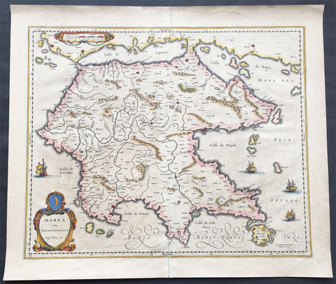
1640 Blaeu Antique Map of the Peloponnese or Morea Peninsula, Greece
- Title : Morea olim Peloponnesus..Guil. Blaeu exc.
- Date : 1640
- Condition: (A+) Fine Condition
- Ref: 70300
- Size: 22in x 19in (560mm x 485mm)
Description:
This beautifully engraved hand coloured original 1st edition antique map of the southern Greek peninsular of the Peloponnesusor Morea was published in the 1640 Latin edition of Joan Blaeu's Atlas Nouvs.
The peninsula has been inhabited since prehistoric times. Its modern name derives from ancient Greek mythology, specifically the legend of the hero Pelops who was said to have conquered the entire region. The namePeloponnesos means "Island of Pelops". During the Middle Ages, the peninsula was known as the Morea. According to folk etymology, this is because the Crusaders found it densely planted with mulberry trees (Greek: moreai) used by the flourishing silk industry.
Blaeu is one of the most revered map makers of all time and it is easy to see why in this beautiful original map. The high level of the topographical detail, the quality of the paper, the artistic professionalism of the engraving and the beauty of the original hand colouring combine to produce a work of art that is both functional and of exceptional beauty. (Ref: Koeman; M&B)
General Description:
Paper thickness and quality: - Heavy and stable
Paper color: - off white
Age of map color: - Original
Colors used: - Yellow, pink, red, blue, green
General color appearance: - Authentic
Paper size: - 22in x 19in (560mm x 485mm)
Plate size: - 22in x 19in (560mm x 485mm)
Margins: - Min 1in (25mm)
Imperfections:
Margins: - Bottom centerfold re-joined slight separation
Plate area: - Light brush marks across page
Verso: - Light brush marks across page
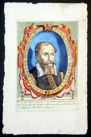
1632 Henricus David Large Antique Portrait of Cartographer Giovanni A Magini
- Title : Io. Antonius Maginus Pat. Mathemat. In Bonon. Gymn. Profess
- Date : 1632
- Condition: (A+) Fine Condition
- Ref: 92835
- Size: 17 1/2in x 11in (445mm x 280mm)
Description:
This fine beautifully hand coloured original antique portrait of the Italian Cartographer Giovanni Antonio Magini was engraved by Henricus David in 1632 - date is engraved below portrait.
Giovanni Antonio Magini (1555-1617) was an Italian mathematician, cartographer and Professor of Astronomy in Bologna. He is responsible for publishing an edition ofPtolemy's Geographia in 1596 that contained 27 maps of the ancient world drawn from the text of Claude Ptolemy, along with 27 contemporary or modern maps. His maps were used by Blaeu in 1640. (Ref: Tooley; M&B)
General Description:
Paper thickness and quality: - Heavy and stable
Paper color: - off white
Age of map color: - Original
Colors used: - Yellow, green, red, brown.
General color appearance: - Fresh
Paper size: - 17 1/2in x 11in (445mm x 280mm)
Plate size: - 12n x 8 1/2in (305mm x 215mm)
Margins: - Min 1in (25mm)
Imperfections:
Margins: - Light dis-colouration in top margin
Plate area: - None
Verso: - None
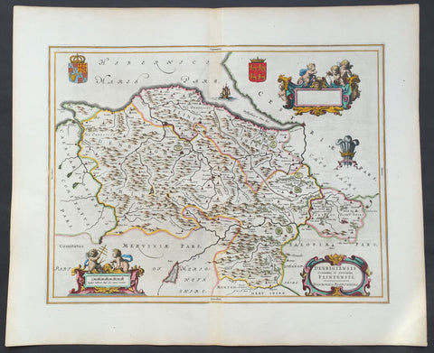
1647 Blaeu Antique Map of The Welsh Counties of Denbigh & Flintshire
- Title : Denbigiensis comitatus et Comitatus Flintensis - Denbigh et Flintshire
- Ref #: 31034
- Size: 24in x 20in (610mm x 510mm)
- Date : 1647
- Condition: (A+) Fine Condition
Description:
This beautifully hand coloured original antique map of the Welsh counties of Denbigh & Flintshire was published in the 1647 Dutch edition of Joan Blaeus Atlas Novus.
Blaeu's reference for the topographical data for this map derive from John Speeds maps of Great Britain from the 1611 Empire of Great Britaine - the beautiful decoration, though, is distinctly Blaeus.
Background: Blaeu is one of the most revered map makers of all time and it is easy to see why in this beautiful original map.
The high level of the topographical detail, the quality of the paper, the artistic professionalism of the engraving and the beauty of the original hand colouring combine to produce a work of art that is both functional and of exceptional beauty. (Ref: Koeman; M&B)
General Description:
Paper thickness and quality: - Heavy and stable
Paper color: - White
Age of map color: - Early
Colors used: - Yellow, pink, red, blue, green
General color appearance: - Authentic
Paper size: - 24in x 20in (610mm x 510mm)
Plate size: - 19 1/2in x 15in (495mm x 380mm)
Margins: - Min 1in (25mm)
Imperfections:
Margins: - None
Plate area: - None
Verso: - None
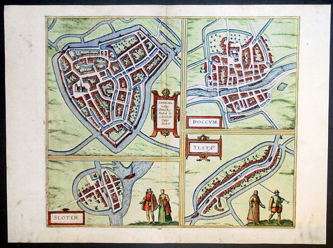
1575 Braun & Hogenberg Antique Print Sneek Dokkum Ylst Frisia Sloten Netherlands
- Title : Sneecha, vulgo Sneeck Frisiae Occidentalis Oppidum. - Doccum - Sloten - Ylsta
- Ref #: 30261
- Size: 21in x 16in (535mm x 410mm)
- Date : 1575
- Condition: (A+) Fine Condition
Description:
This fine beautifully hand coloured original antique map a birds-eye view of the towns of Sneek, Dokkum, Ylst and Sloten in Frisia, the Netherlands was published by Georg Braun & Frans Hogenberg for the 1575 atlas of town plans Civiates Orbis Terrarum Vol II (1572-1612) intended as a companion to Abraham Ortelius's master Atlas Theatrum Orbis Terrarum published in 1570.
Background of Civitates Orbis Terrarum
The first volume of the Civitates Orbis Terrarum was published in Cologne in 1572. The sixth and the final volume appeared in 1617.
This great city atlas, edited by Georg Braun and largely engraved by Franz Hogenberg, eventually contained 546 prospects, bird-eye views and map views of cities from all over the world. Braun (1541-1622), a cleric of Cologne, was the principal editor of the work, and was greatly assisted in his project by the close, and continued interest of Abraham Ortelius, whose Theatrum Orbis Terrarum of 1570 was, as a systematic and comprehensive collection of maps of uniform style, the first true atlas.
For a variety of reasons town plans were comparatively latecomers in the long history of cartography. Few cities in Europe in the middle ages had more than 20,00 inhabitants and even London in the late Elizabethan period had only 100-150,000 people which in itself was probably 10 times that of any other English city. The Nuremberg Chronicle in 1493 included one of the first town views of Jerusalem, thereafter, for most of the sixteenth century, German cartographers led the way in producing town plans in a modern sense. In 1544 Sebastian Munster issued in Basle his Cosmographia containing roughly sixty-six plans and views, some in the plan form, but many in the old panorama or birds eye view. (Ref: Tooley; M&B)
Condition Report:
Paper thickness and quality: - Heavy and stable
Paper color: - off white
Age of map color: - Early
Colors used: - Green, blue, red, yellow
General color appearance: - Authentic
Paper size: - 21in x 16in (535mm x 410mm)
Plate size: - 16 1/2in x 14in (420mm x 355mm)
Margins: - Min 1in (25mm)
Imperfections:
Margins: - Light soiling in margins
Plate area: - None
Verso: - None
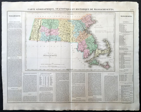
1825 Carey & Lea, Buchon Large Antique Map of the State of Massachusetts, USA
-
Title : Carte Geographique, Statistique et Historique Du Massachusetts
- Ref #: 70007
- Size: 27 1/2in x 21 1/2in (700mm x 545mm)
- Date : 1825
- Condition: (A+) Fine Condition
Description:
This large beautifully hand coloured original antique map was published in the 1825 French edition of Carey & Lea's American Atlas by Jean Alexandre Buchon.
This map is in exceptionally fine condition, on clean, sturdy and stable heavy paper, heavy engraving and beautiful original hand colour.
In 1822, Henry Charles Carey and Isaac Lea published their American Atlas. This volume was based on Emmanuel Las Cases' Atlas Historique of 1803, with updated maps and text modified by Carey, a political economist.
He considered himself an American foil to John Stuart Mill and the London economists who were proclaimers of "the gloomy science" influenced by Ricardo and Malthus. Instead of preaching overpopulation and degeneration of the human species, Carey illustrated the nations of the western hemisphere through maps that showed an expanding region with ample promise of developing into lands of great new opportunity and growth. The sheets from this atlas, which cover North America, Central America, South America and the West Indies, are comprised of an engraved map surrounded by text documenting the history, climate, population and so forth of the area depicted. The atlas is particularly known for its excellent early maps of the states and territories of the United States. Many of these maps were drawn by Fielding Lucas, Jr., an important Baltimore cartographer. All of the maps show excellent and very up-to-date detail, providing fine verbal and graphic pictures of states and territories in the early 19th century (Ref: M&B; Tooley)
General Description:
Paper thickness and quality: - Heavy and stable
Paper color: - white
Age of map color: - Original
Colors used: - Yellow, green, blue, pink
General color appearance: - Authentic
Paper size: - 27 1/2in x 21 1/2in (700mm x 545mm)
Margins: - min. 1in (25mm)
Imperfections:
Margins: - None
Plate area: None
Verso: - None
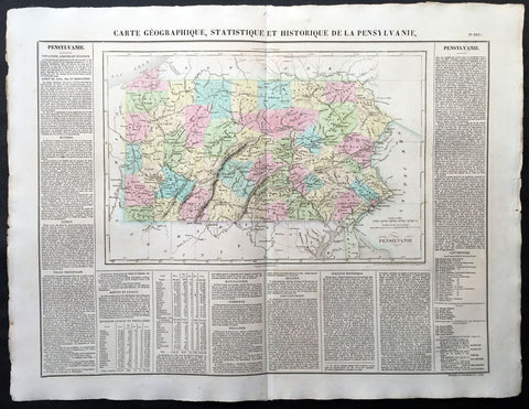
1825 Carey & Lea, Buchon Large Antique Map of the State of Pennsylvania, USA
-
Title : Carte Geographique, Statistique et Historique De la Pensylvanie
- Ref #: 70012
- Size: 27 1/2in x 21 1/2in (700mm x 545mm)
- Date : 1825
- Condition: (A+) Fine Condition
Description:
This large beautifully hand coloured original antique map was published in the 1825 French edition of Carey & Lea's American Atlas by Jean Alexandre Buchon.
This map is in exceptionally fine condition, on clean, sturdy and stable heavy paper, heavy engraving and beautiful original hand colour.
In 1822, Henry Charles Carey and Isaac Lea published their American Atlas. This volume was based on Emmanuel Las Cases' Atlas Historique of 1803, with updated maps and text modified by Carey, a political economist.
He considered himself an American foil to John Stuart Mill and the London economists who were proclaimers of "the gloomy science" influenced by Ricardo and Malthus. Instead of preaching overpopulation and degeneration of the human species, Carey illustrated the nations of the western hemisphere through maps that showed an expanding region with ample promise of developing into lands of great new opportunity and growth. The sheets from this atlas, which cover North America, Central America, South America and the West Indies, are comprised of an engraved map surrounded by text documenting the history, climate, population and so forth of the area depicted. The atlas is particularly known for its excellent early maps of the states and territories of the United States. Many of these maps were drawn by Fielding Lucas, Jr., an important Baltimore cartographer. All of the maps show excellent and very up-to-date detail, providing fine verbal and graphic pictures of states and territories in the early 19th century (Ref: M&B; Tooley)
General Description:
Paper thickness and quality: - Heavy and stable
Paper color: - white
Age of map color: - Original
Colors used: - Yellow, green, blue, pink
General color appearance: - Authentic
Paper size: - 27 1/2in x 21 1/2in (700mm x 545mm)
Margins: - min. 1in (25mm)
Imperfections:
Margins: - Light age toning
Plate area: Light age toning
Verso: - Light age toning
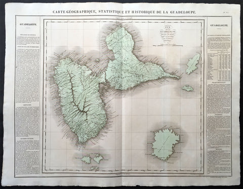
1825 Carey & Lea Buchon Large Map of the Island of Guadeloupe, Caribbean
-
Title : Carte Geographique, Statistique et Historique De La Guadeloupe
- Ref #: 70028
- Size: 27 1/2in x 21 1/2in (700mm x 545mm)
- Date : 1825
- Condition: (A+) Fine Condition
Description:
This large beautifully hand coloured original antique map was published in the 1825 French edition of Carey & Lea's American Atlas by Jean Alexandre Buchon.
This map is in exceptionally fine condition, on clean, sturdy and stable heavy paper, heavy engraving and beautiful original hand colour.
In 1822, Henry Charles Carey and Isaac Lea published their American Atlas. This volume was based on Emmanuel Las Cases' Atlas Historique of 1803, with updated maps and text modified by Carey, a political economist.
He considered himself an American foil to John Stuart Mill and the London economists who were proclaimers of "the gloomy science" influenced by Ricardo and Malthus. Instead of preaching overpopulation and degeneration of the human species, Carey illustrated the nations of the western hemisphere through maps that showed an expanding region with ample promise of developing into lands of great new opportunity and growth. The sheets from this atlas, which cover North America, Central America, South America and the West Indies, are comprised of an engraved map surrounded by text documenting the history, climate, population and so forth of the area depicted. The atlas is particularly known for its excellent early maps of the states and territories of the United States. Many of these maps were drawn by Fielding Lucas, Jr., an important Baltimore cartographer. All of the maps show excellent and very up-to-date detail, providing fine verbal and graphic pictures of states and territories in the early 19th century (Ref: M&B; Tooley)
General Description:
Paper thickness and quality: - Heavy and stable
Paper color: - white
Age of map color: - Original
Colors used: - Yellow, green, blue, pink
General color appearance: - Authentic
Paper size: - 27 1/2in x 21 1/2in (700mm x 545mm)
Margins: - min. 1in (25mm)
Imperfections:
Margins: - Light age toning
Plate area: Light age toning
Verso: - Light age toning
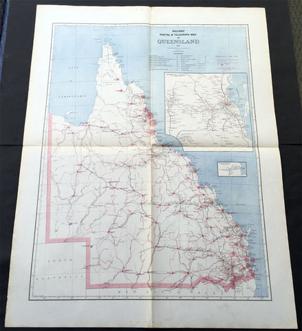
1888 Picturesque Atlas of Australia Large Antique Railway Map of Queensland
- Title : Railway Postal & Telegraph Map of Queensland
- Ref #: 50329
- Size: 34in x 26in (865mm x 660mm)
- Date : 1888
- Condition: (A+) Fine Condition
Description:
This very large fine original antique lithograph layered coloured map of Queensland showing the extent of Railway and postal lines, was engraved in 1888 - the date is engraved in the title - with index page - by Alex J Scally - was published in the extremely significant Australian & New Zealand publication The Picturesque Atlas of Australasia between 1886-88.
These maps were some of the best maps published at the time in the "Modern" look. The colour is bright, the engraving extremely fine and the paper heavy and stable.
General Description:
Paper thickness and quality: - Light & stable
Paper color: - White
Age of map color: - Original
Colors used: - Blue, red
General color appearance: - Authentic
Paper size: - 34in x 26in (865mm x 660mm)
Plate size: - 34in x 26in (865mm x 660mm)
Margins: - Min 1in (25mm)
Imperfections:
Margins: - None
Plate area: - Folds as issued
Verso: - None
1664 Blaeu Large Antique Map of The Welsh County of Breknock
- Title : Comitatus Brechiniae Breknoke
- Ref #: 01-4244
- Size: 25 1/2in x 21 1/2in (650mm x 545mm)
- Date : 1664
- Condition: (A+) Fine Condition
Description:
This beautifully hand coloured original antique map of the Welsh county of Brecknock was published in the 1664 Dutch edition of Joan Blaeus Atlas Major.
Blaeus reference for the topographical data is from John Speeds maps from the 1611 Empire of Great Britaine - the beautiful decoration, though, is distinctly Blaeus.
This is a beautiful map with a deep impression, original margins, wonderful hand colouring and strong, stable paper. (Ref: Koeman; Tooley; M&B)
General Description:
Paper thickness and quality: - Heavy and stable
Paper color: - White
Age of map color: - Later
Colors used: - Yellow, pink, red, blue, green
General color appearance: - Authentic
Paper size: - 25 1/2in x 21 1/2in (650mm x 545mm)
Plate size: - 20in x 15in (510mm x 380mm)
Margins: - Min 2in (50mm)
Imperfections:
Margins: - None
Plate area: - None
Verso: - None

1735 Homann Large Antique Map of Oran, Algeria, North Africa
- Title : Topographica Repræsentatio Barbarici Portus et Urbis Munitæ Oran... Nuremberg, 1732
- Ref #: 43187
- Size: 24 1/2in x 21 1/4in (620mm x 540mm)
- Date : 1735
- Condition: (A+) Fine Condition
Description:
This large fine beautifully hand coloured original antique map and view of the City of Oran & Environs in the North African country of Algeria, as it was being captured by the Spanish in 1732, was published by Homann Heirs in ca 1735.
Background: Chart of the environs of Oran in Algeria, with a panorama of the city and environs, decorated with several sailing battle ships. In 1509 Spain captured Oran from the Moors, but in 1708, with Spain disadvantaged by the War of the Spanish Succession, they were driven out by the Turkish Bey, Mustapha Ben Youssef. In 1732 José Carrillo de Albornoz, 1st Duke of Montemar (1671-1747), recaptured Oran, causing this map to be published, after which the Spanish held the city until 1792. When the Spanish saw no point in keeping it, when it was handed over to the Bey of Algiers(Ref: Tooley; M&B)
General Description:
Paper thickness and quality: - Heavy and stable
Paper color: - off white
Age of map color: - Original
Colors used: - Yellow, green, blue, pink
General color appearance: - Authentic
Paper size: - 24 1/2in x 21 1/4in (620mm x 540mm)
Plate size: - 22 1/2in x 19 1/2in (570mm x 500mm)
Margins: - Min 1/2in (12mm)
Imperfections:
Margins: - None
Plate area: - None
Verso: - None
1711 Claude Delisle Large Antique Map of Rome and Regions, Italy
- Title : Regionum Italiae Mediarum Tabula Geographica Par Guill. Delisle.....1711
- Ref #: 31904
- Size: 28in x 21in (660mm x 535mm)
- Date : 1711
- Condition: (A+) Fine Condition
Description:
This large beautifully engraved hand coloured original antique map of Rome and the regions surrounding the ancient capital was engraved in 1711 - the date is engraved at the foot of the map - and was published by Guillaume Delisle in the Atlas Nouveau. (Ref: M&B; Tooley)
Condition Report
Paper thickness and quality: - Very heavy and stable
Paper color: - Off white
Age of map color: - Original
Colors used: - Yellow, green, pink
General color appearance: - Authentic
Paper size: - 28in x 21in (660mm x 535mm)
Plate size: - 24in x 18 1/2in (610mm x 470mm)
Margins: - min. 1in (25mm)
Imperfections:
Margins: - Repair to bottom margin
Plate area: - Light creasing and slight discolouration to bottom centerold
Verso: - None
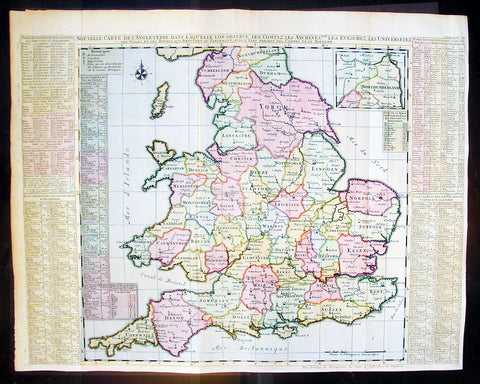
1720 Chatelain Antique Map of England & Wales
- Title : Nouvelle Carte De L Angleterre Dans Laquelle Lon Observe Lez Comtez Les Archives
- Ref #: 16370
- Size: 25 1/2in x 20 1/2in (650m x 430m)
- Date : 1720
- Condition: (A+) Fine Condition
Description:
This large fine beautifully hand coloured original antique map of England & Wales - with side text on all the different counties - by Henri Abraham Chatelain in 1720 was published in his famous Atlas Historique.
This is a magnificent map with bright hand colouring, clean strong sturdy paper and a heavy clear impression.
The Atlas Historique published by Henri Chatelain was part of a major work of its time, an encyclopedia in seven volumes, including geography as one of its main subjects. The text was by Nicholas Gueudeville and the maps by Chatelain. The Atlas included one of the finest map of America (four sheets) surrounded by vignettes and decorative insets. The Atlas Historique was completed between 1705 and 1720, further issues were published up to 1739. The series was published in Amsterdam, with Chatelain’s maps based on those of G. Delisle. (Ref: M&B; Tooley)
General Description:
Paper thickness and quality: - Heavy and stable
Paper color: - White
Age of map color: - Early
Colors used: - Pink, green, yellow, blue
General color appearance: - Authentic
Paper size: - 25 1/2in x 20 1/2in (650m x 430m)
Plate size: - 25in x 19 1/2in (635m x 495mm)
Margins: - min. 1/2in (10mm)
Imperfections:
Margins: - None
Plate area: - Folds as issued
Verso: - None
1574 Munster Large Antique Print View of The French City of Tours
- Title : Die Statt Tours
- Ref #: 22614
- Size: 16in x 13in (410mm x 330mm)
- Date : 1574
- Condition: (A+) Fine Condition
Description:
This large finely engraved original antique print a view of the French city of Tours was published by Sebastian Munster in the 1574 edition of Cosmographia.
Tours is a city located in the centre-west of France. It is the administrative centre of the Indre-et-Loire department and the largest city in the Centre-Val de Loire region of France (although it is not the capital, which is the region's second-largest city, Orléans). Tours stands on the lower reaches of the River Loire, between Orléans and the Atlantic coast. The surrounding district, the traditional province of Touraine, is known for its wines, for the alleged perfection (as perceived by some speakers) of its local spoken French, and for the Battle of Tours (732).
Background: For a variety of reasons town plans were comparatively latecomers in the long history of cartography. Few cities in Europe in the middle ages had more than 20,00 inhabitants and even London in the late Elizabethan period had only 100-150,000 people which in itself was probably 10 times that of any other English city. The Nuremberg Chronicle in 1493 included one of the first town views of Jerusalem, thereafter, for most of the sixteenth century, German cartographers led the way in producing town plans in a modern sense. In 1544 Sebastian Munster issued in Basle hisCosmographia containing roughly sixty-six plans and views, some in the plan form, but many in the old panorama or birds eye view.
Sebastian Münster (1488-1552) was a German cartographer, cosmographer, and Hebrew scholar whose work Cosmographia (1544; "Cosmography") was the earliest German description of the world and a major work in the revival of geographic thought in 16th-century Europe. It had numerous editions in different languages including Latin, French, Italian, English, and even Czech. Altogether, about 40 editions of the Cosmographiaappeared between 1544 and 1628 and was one of the most successful and popular books of the 16th century. Münster was a major influence in popular thinking in Europe for the next 200 years.
This success was due not only to the level of descriptive detail but also to the fascinating full page maps & views as well as smaller woodcuts that were included in the text. Many of the woodcuts were executed by famous engravers of the time including Hans Holbein the Younger, Urs Graf, Hans Rudolph Manuel Deutsch, and David Kandel.
Aside from the well-known maps present in the Cosmographia, the text is thickly sprinkled with vigorous views: portraits of kings and princes, costumes and occupations, habits and customs, flora and fauna, monsters, wonders, and horrors about the known -- and unknown -- world, and was undoubtedly one of the most widely read books of its time.
Münster acquired the material for his book in three ways. Firstly he researched all available literary sources across Germany, Switzerland and other parts of Europe. Secondly he obtained original manuscript material from locals all over Europe for description of the countryside, cities, villages, towns, rivers and local history. Finally, he obtained further material first hand on his travels (primarily in south-west Germany, Switzerland, and Alsace).
In 1588 Sebastian Petri re-released Cosomgraphia and re-issued many of Munsters maps and views in the "copperplate style". The maps in this release were more sophisticated than with earlier publications ofCosomgraphia and were based on the 1570 release of Abraham Ortelius monumental work Theatrum Orbis Terrarum.(Ref: Tooley; M&B)
General Description:
Paper thickness and quality: - Light and stable
Paper color: - off white
Age of map color: -
Colors used: -
General color appearance: -
Paper size: - 16in x 13in (410mm x 330mm)
Plate size: - 16in x 13in (410mm x 330mm)
Margins: - 1/2in (12mm)
Imperfections:
Margins: - None
Plate area: -None
Verso: - None
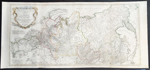
1762 D Anville Very Large Antique Map of Russia, Siberia, Mongolia, China, Japan
- Title : Troisieme Partie De La Carte D' Asia Contenant La Siberie...MDCCLII
- Ref #: 50604
- Size: 55in x 22 1/2in (1.25m x 570mm)
- Date : 1762
- Condition: (A+) Fine Condition
Description:
This very large beautifully engraved hand coloured original antique map of Russia, Siberia and Central Asia was engraved by Jean-Baptiste Bourguinon D'Anville in 1762 - the date is engraved in the title - and was published in the large elephant folio atlas Atlas Generale.
These maps are hard to find in such good condition and make fantastic historical reference tools due to the size and high level of detail as with all D'Anvilles work. (Ref: Tooley, M&B)
General Description:
Paper thickness and quality: - Heavy and stable
Paper color: - White
Age of map color: - Original
Colors used: - Yellow, pink, green
General color appearance: - Authentic
Paper size: - 55in x 22 1/2in (1.25m x 570mm)
Plate size: - 43in x 21in (1.10mm x 535mm)
Margins: - Min 1in (25mm)
Imperfections:
Margins: - None
Plate area: - Light creasing & soiling along L&R folds
Verso: - None
1683 Mallet Antique Map of Australia Cape York Peninsula Gulf of Carpenteria PNG
- Title : Nouvelle Guinee et Carpentarie
- Ref #: 50601
- Size: 8in x 6in (205mm x 152mm)
- Date : 1682
- Condition: (A+) Fine Condition
Description:
This hand coloured original antique very early map of Cape York Peninsula, the Gulf of Carpenteria and New Guinea - depicted before the Torres Strait was charted - was published as part of the 1683 edition of Alain Manesson Mallet's 1630 - 1706 Description de l' Univers.
Background:
The first detailed published map to show any part of Queensland (Tully). Shows New Guinea , the east coast of Cape York Peninsula and part of Arnhem Land.
Although not a particularly large map, the significance of Mallet's map of Carpentaria and New Guinea is underrated. It is essentially the first map to concentrate specifically on the Dutch discoveries in Queensland by Jan Cartenszoon in the Pera and the Arnhem that left Ambon on 21 January 1623 and reached the western side of Cape York Peninsula on 12 April. Although De Jode's rare and famous map 'Novae Guineae Forma & Situs', published almost a century earlier also charts the same area, it shows a fictitious Queensland based on the contemporary beliefs of a 'Terra Australis Incongita', or unknown southland.
Mallet names 'Coen R', one of the rivers discovered and named by Carstensz in 1623. No other Australian place names are shown except 'Carpentarie' on the Cape York Peninsula . Mallet places an interesting reference at the entrance of the Gulf of Carpentaria, "Les onze mille vierges", referring to the eleven thousand virgins of Cologne . A text carved into stone at the Church of Saint Ursula refers to the martyrdom of virgins.
Mallet was a French Engineer who in his early days took service with the Portuguese Army. He later returned to France and served Louis XIV. In 1683 he published Description de l' Univers which contained many hundreds of maps, plans and views. A German edition was published in 1686.
This is a beautifully engraved and hand coloured print in excellent condition. (Ref: Tooley; M&B)
Condition Report
Paper thickness and quality: - Heavy and stable
Paper color: - white
Age of map color: - Early
Colors used: - Yellow, green, blue, red
General color appearance: - Authentic
Paper size: - 8in x 6in (205mm x 152mm)
Plate size: - 6 1/2in x 5in (165mm x 127 mm)
Margins: - min. 1/2in (12mm)
Imperfections:
Margins: - None
Plate area: None
Verso: - None
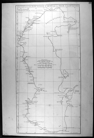
1754 D Anville Large Antique Map of The Caspian Sea
- Title : Essai D Une Nouvelle Carte de la Mer Caspienne...November 1754
- Ref #: 92317
- Size: 21 1/2in x 14 1/2in (550mm x 370mm)
- Date : 1754
- Condition: (A+) Fine Condition
Description:
This large original antique map of of the Caspian Sea by Jean Baptiste Bourguignon D'Anville was engraved in 1754 - dated - and was published in D Anville's large elephant folio Atlas Generale. (Ref: M&B; Tooley)
General Description:
Paper thickness and quality: - Heavy and stable
Paper color: - off white
Age of map color: -
Colors used: -
General color appearance: -
Paper size: - 21 1/2in x 14 1/2in (550mm x 370mm)
Plate size: - 20 3/4in x 10 1/2in (525mm x 270mm)
Margins: - Min 1/2in (12mm)
Imperfections:
Margins: - None
Plate area: - Two very small worm holes bottom left
Verso: - None

1647 Olivarius Vredius Antique Map of Roman Europe Flanders, Germany, France
- Title : Francorum Primae Sedes...Incisum Bruges a Joe F Jois...Olivario Vredio...1647
- Ref #: 60040
- Size: 16 1/2in x 14in (420mm x 355mm)
- Date : 1647
- Condition: (A+) Fine Condition
Description:
This fine scarce beautifully engraved original antique map of central & western Roman Europe centering on what is today Belgium, the Southern Netherlands, Northern France and Western Germany - was engraved in 1647 - dated - and published by Olivarius Vredius (Olivier de Wree)in the 1652 edition of Historiae Comitum Flandriae
Historiae Comitum Flandriae was an important historical work on the origin and early history of Flanders by the well-known historian Olivarius Vredius - Olivier de Wree - (1596-1652) from Bruges. Vredius belongs to the most prominent representatives of late-Belgian humanism and his historical works are still considered to be of high value. (Ref: M&B; Tooley)
General Description:
Paper thickness and quality: - Heavy & stable
Paper color: - White
Age of map color: -
Colors used: -
General color appearance: -
Paper size: - 16 1/2in x 14in (420mm x 355mm)
Plate size: - 12 1/2in x 11in (320mm x 280mm)
Margins: - Min 1in (25mm)
Imperfections:
Margins: - None
Plate area: - Light blue underlining some names, light creasing
Verso: - None
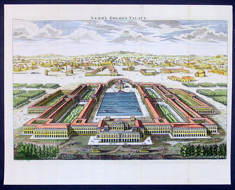
1650 Fuller Antique Print a View of Neros Palace Rome
- Title : Neros Golden Palace
- Ref : 24312
- Size: 17in X 13in (435mm x 330mm)
- Date : 1650
- Condition: (A+) Fine Condition
Description:
This finely engraved hand coloured original antique print a view of Neros Golden Palace in Rome was published in 1650 by Thomas Fuller in his unique book of the Holy Land A Pisagh-Sight of Palestine
Fuller, a loyalist during the English Civil War of the mid 17th century, wrote Pisagh-Sightduring a forced exile in Waltham.
The book was an early success and confirmed the genial divines contention the “the booksellers have always done well by me”. His earlier studies in poetry and history and his droll humor contribute to the geographical description in “Pisagh-Sight” while the cartography in the book is derived from that of Adrichom sixty years before.
The book contained 21 wonderfully engraved maps on the Holy Land and displayed unusual charm in their Vignettes and scenes. For all its lively and playful erudition, Pisagh-Sight is one of the great books on the topography of the Holy Land. (Ref: Nebenzahl; Tooley; M&B)
General Description:
Paper thickness and quality: - Heavy and stable
Paper color: - Off white
Age of map color: - Early
Colors used: - Yellow, pink, orange, green
General color appearance: - Authentic
Paper size: - 17in X 13in (435mm x 330mm)
Margins: - Min 1/2in (12mm)
Imperfections:
Margins: - None
Plate area: - Folds as issued
Verso: - None
1610 Johannes Kip Antique Map of the County of Flintshire, Wales, Great Britain
- Title : Flint Comitatus quem Ordovices olim Incolucrunt
- Ref #: 01-3604
- Size: 15in x 13in (380mm x 330mm)
- Date : 1610
- Condition: (A+) Fine Condition
Description:
A very attractive early original hand coloured antique map of Flintshire (Welsh: Sir y Fflint) Wales, based on the first survey of the county by Christopher Saxton, was engraved by William Kip for William Camden's Britannia* (London: 1607-1637).
As well as still being the earliest printed map of Flintshire at an 'affordable' price it is also the first detailed one dedicted solely to the county.
General Definitions:
Paper thickness and quality: - Heavy and stable
Paper color : - off white
Age of map color: - Early
Colors used: - Blue, yellow, green, brown
General color appearance: - Authentic
Paper size: - 15in x 13in (380mm x 330mm)
Plate size: - 13in x 11in (330mm x 280mm)
Margins: - Min 1in (25mm)
Imperfections:
Margins: - Light soiling to margin edges
Plate area: - None
Verso: - None
Background:
Britannia', was one of the most popular and influential books of the period. The work of the Elizabethan antiquarian, William Camden (1551-1623), it was a detailed historical and topographical description of Great Britain. Its patriotic sentiments, in particular, both appealed to and generated the growing sense of nationalism that was coursing through late Tudor / early Stuart society. Between 1607 and 1637, county maps engraved by William Kip and William Hole, and based largely on Saxton's surveys, were added. These maps have the distinction of being the first set to show each county individually as opposed to several being grouped together on one page. Camden's Britannia continued to be published well into the 19th century; from 1695 to 1772, county maps by Robert Morden were used, and from 1789 to c.1815, those by the renowned John Cary.
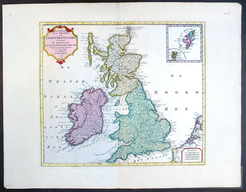
1750 Isaac Tirion Large Antique Map of Great Britain & Ireland
- Title : Nieuwe Kaaart van de Eilanden Groot Britannie behelsende Het Koningryk Engeland
- Ref #: 70087
- Size: 21 1/2in x 17in (545mm x 435mm)
- Date : 1750
- Condition: (A+) Fine Condition
Description:
This beautifully hand coloured original antique map of Great Britain & Ireland was published by Isaac Tirion in 1750.
Isaac Tirion was a successful publisher in Amsterdam during the 18th century who produced extensive volumes of Dutch town plans as well as a number of atlases with maps usually based on those of G. Delisle. His world atlases were finely engraved and beautifully colored as with this map for auction. (Ref: Tooley; M&B)
General Description:
Paper thickness and quality: - Heavy and stable
Paper color: - off white
Age of map color: - Original
Colors used: - Green, pink, yellow
General color appearance: - Authentic
Paper size: - 21 1/2in x 17in (545mm x 435mm)
Plate size: - 14 1/2in x 13in (370mm x 330mm)
Margins: - Min 1in (25mm)
Imperfections:
Margins: - None
Plate area: - None
Verso: - None
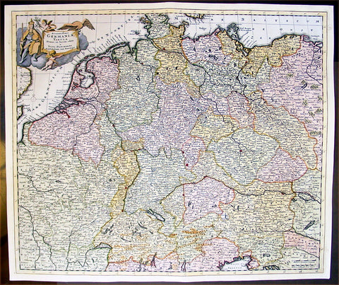
1699 Danckerts Antique Map of Germany & Central Europe Poland to France to Italy
- Title : Accuratissima Germaniae Tabula
- Ref #: 16295
- Size: 24in x 20 1/2in (610mm x 520mm)
- Date : 1699
- Condition: (A+) Fine Condition
Description:
This large beautifully hand coloured original antique map of central Europe - centering on the various German States but stretching from Poland in the east to France in the west and Venice to the south - by Justus Danckerts was published in 1699.
In the latter half of the fifteenth century Germany, though nominally still part of the Holy Roman Empire, was a fragmented land, split into a score of principalities and Imperial Cities, fiercely jealous of each other but having in common an extraordinary creative urge which produced builders of great churches and cathedrals, workers in stone and wood, metal engravers, painters and makers of scientific instruments, who were the envy of the world. Of all their achievements, the invention of movable-type printing was to have the most profound effect on human relationships. Printing industries soon grew up in many cities, including Nuremberg and Augsburg where wood engraving already flourished and which, with Basle and Strassburg, were also the centres of geographical knowledge. Not only were local and regional maps produced in considerable variety and quantity, but more particularly the geographers and mathematicians of Nuremberg are famous for their globes of the world, some of which are still preserved.
The most important map of the whole of Germany produced in this period was a manuscript dated c. 1464 by Nicholas Cusanus (Khryfts), Cardinal, humanist and scholar, friend of Toscanelli, the Italian geographer, and one of the most brilliant men of his day. The map covering Germany, Southern Scandinavia and the Baltic was printed in 1491, long after the author's death, and it served as a model for a similar map in the Nuremberg Chronicle. We have written in some detail in Chapter 4 of this famous book, first published in 1493, which contained a great number of woodcut views and maps, but as far as cartography is concerned the printing of Ptolemy's Geographia at Ulm in 1482 (and 1486) - the first edition with woodcut maps - was an event of the greatest importance. The most ambitious editions of the Ptolemy maps appeared in 1513 in Strassburg, containing not only maps of the ancient world but also twenty new ones, including one of the 'New World', based on the latest contemporary.
knowledge. This was produced under the guidance of Martin Waldseemuller, a German cartographer, at St Die' in Lorraine, at that time a noted centre of learning. Other editions followed in the years up to 1 541, overlapping with the newer work of Sebastian Mu'~nster, an eminent mathematician and linguist, who settled in Basle and whose prolific output of atlases and maps contained also many plans and views of the great cities of the time. These in turn were superseded by Braun and Hogenberg's Civitates Orbis Terrarumissued in Cologne between the years 1572 and 1618, which was one of the most famous publications of the period.
In the seventeenth century Dutch supremacy in map making and publishing overshadowed Germany no less than England and France and there was to be no revival until the foundation in Nuremberg about the year 1700 of the printing firm of J. B. Homann, whose business acumen started a resurgence of map publishing. He became a member of the Berlin Academy of Sciences and was appointed Geographer to the Emperor in 1715. The business was continued by his son, Johann Christoph, and was eventually bequeathed to the founder's son-in-law on condition that he continued the business under the name of Homann Heirs. Other notable publishing houses active during the century were run by Matthaus Seutter and Tobias Lotter in the rival city of Augsburg. (Ref: Tooley; M&B)
General Description:
Paper thickness and quality: - Heavy and stable
Paper color: - off white
Age of map color: - Early
Colors used: - Yellow, green, red, brown.
General color appearance: - Authentic and fresh
Paper size: - 24in x 20 1/2in (610mm x 520mm)
Plate size: - 23in x 19 1/2in (585mm x 495mm)
Margins: - Min 1/2in (10mm)
Imperfections:
Margins: - None
Plate area: - None
Verso: - Bottom centerfold re-joined, no loss.
1888 Pic Atlas Large Antique Map of the North Island of New Zealand
- Title : General Map of The North Island of New Zealand
- Ref #: 50321
- Size: 28in x 18in (710mm x 460mm)
- Date : 1888
- Condition: (A+) Fine Condition
Description:
This large original antique map of the North Island of New Zealand was engraved in 1888 - the date is engraved at the foot of the map - by Alex J Scally and was published in the extremely significant Australian & New Zealand publicationThe Picturesque Atlas of Australasia between 1886-88. Also includes an index to the map on the verso giving names and locations of places on the map.
These maps were some of the best maps published at the time in the "Modern" look. The colour is bright, the engraving extremely fine and the paper heavy and stable.
The Picturesque Atlas of Australasia was published in Sydney between 1886-88. Many of its over 700 wood-engraved illustrations were specially commissioned works by leading Australian artists.
It was released in 42 separate editions usually bound into three large volumes and sold a remarkable 50,000 copies.
Its publication was one of the most significant cultural projects in nineteenth-century Australia. Writers, artists, academics and politicians came together to prepare a book of unprecedented grandeur and ambition, and a publishing company was established to produce and publish it. The seven hundred engravings on steel and wood contained in the Picturesque Atlas were among the finest engravings to be found anywhere in the world at this time.
The Atlas was a collegial project, staffed by a large number of artists and garnering an unusual number of contributors for one work. Lightly supervised by the former Sydney Morning Herald editor Andrew Garran it was lavishly produced at the Wynyard Square headquarters of the Atlas company. It had the services of the Melburnian journalist and public figure James Smith who wrote much of the Victorian and Tasmanian material, and W.H. Traill wrote extensively about Queensland. It was not, of course, an Atlas is the usual sense of the word, maps playing a comparatively minor role. But use of Atlas in the title, Hughes-d'Aeth notes, gave a sense of the scale of the publication both in terms of comprehensiveness and format. As the author points out, calling it an Atlas carries a promise of the exactitude of the relationship between the subject and its representation, and also bears a sense of the acquisitiveness that shadows the imperial phase of cartography.
There were only thirty maps in the Atlas's 800 pages, but there were hundreds of pictures. This is where much of the ideological work of the Atlas was completed and this is where Paper Nation concentrates its analysis. Its first task is to unravel the linguistic ball of string that is the word 'picturesque'. Though Humphrey Repton and Uvedale Price had their opinions, Hughes-d'Aeth is quite right to pick William Gilpin out of the line-up of suspicious aesthetes, for it was he who really popularised the idea of travelling in search of picturesque views. Paper Nation's dissection of the term picturesque is particularly aware of the term's adaptation to colonial usage, and its mutations through time. The picturesque took on an increasingly acquisitive edge, as admiration of the beauty of the land was joined by a concern to exploit it. A 'deep reverence for production' can be seen in the Picturesque Atlas's many illustrations of mines, factories and agricultural processes. The slag heaps of a mine were now as 'picturesque' as a fern-filled valley, but this does mean that the term was evacuated of all meaning. Rather the aesthetic appropriation of the land and its material exploitation were part of a continuum of colonial attitudes, and it was the duty of the Picturesque Atlas to affirm and re-affirm the rightness of European habitation and progress. (Ref: M&B; Tooley)
General Description:
Paper thickness and quality: - Light & stable
Paper color: - White
Age of map color: - Original
Colors used: - Pink, yellow, green, blue
General color appearance: - Authentic
Paper size: - 28in x 18in (710mm x 460mm)
Plate size: - 28in x 18in (710mm x 460mm)
Margins: - Min 1in (25mm)
Imperfections:
Margins: - None
Plate area: - None
Verso: - None
1695 Morden Antique Map The Welsh County of Monmouth
- Title : The County of Monmouth by Robert. Morden
- Ref #: 40869
- Size: 17 1/2in x 15in (445mm x 380mm)
- Date : 1695
- Condition: (A+) Fine Condition
Description:
This fine beautifully hand coloured original antique map of the Welsh county of Monmouth was engraved by Robert Morden & published by Abel Swale & John Churchil for the 1695 edition of Willam Camden's Britannia.
William Camden was an historian who first published his Britannia, a description and history of Britain, in 1586. Written in Latin, the book contained only a general map of the country but had a wide circulation and eventually in 1607 an edition (the sixth) was published with a series of maps with Latin text on the reverse.
Further editions in English were published in 1610 and 1637 but without text. (Many more editions were published up until 1806 with map contributions from Blaeu in 1617, John Bill 1626, Robert Morden 1695-1772 and John Cary 1789-1806)
In the 1610 & 1617 editions the maps were mostly engraved by William Kip and William Hole and were based on those of Christopher Saxton, but six were copied from John Norden.
The map of Pembroke is by George Owen and the general maps of England/Wales, Scotland and Ireland were probably taken from Mercator. Kip reduced the size of each map for Britannia from the originals published by Christopher Saxton in 1579. (Ref: Tooley; M&B)
General Description:
Paper thickness and quality: - Light and stable
Paper color: - off white
Age of map color: - Early
Colors used: - Red, yellow, blue, green, blue
General color appearance: - Authentic
Paper size: - 17 1/2in x 15in (445mm x 380mm)
Plate size: - 16 1/2in x 14in (420mm x 355mm)
Margins: - Min 1/2in (12mm)
Imperfections:
Margins: - 4 small repairs to bottom margin
Plate area: - None
Verso: - None
1817 Tavernier & Lepetit Antique Atlas of Turkey Persia Vietnam, Asia - 22 Prints
- Title : Atlas de Tavernier...Chez M.Me Lepetit...1817
- Ref #: 91592
- Size: 8vo
- Date : 1817
- Condition: (A) Very Good Condition
Description:
This fine original antique of the travels from Turkey, Persia, Central Asia, Vietnam of Jean Baptist Tavernier's was translated from the English by M Henry & M Breton and published by V Lepetit. Paris in 1817 - dated.
This atlas contains 22 copper-plate engraved prints, as listed below.
The atlas covers have been removed with front title page partially detached. Pages are generally clean with light aging to borders, Print V detached, light toning to pages, overall VG, 8vo, each page size is 7in x 5in (180mm x 125mm)
- J B Tavernier
2. Vue de Constantinople
3. Point de Serail a Constantionople
4. Le Trois Eglises
5. Ervan
6. Caravanserail de Cachen
7. Village Camouk ou Circassien
8. Mosquee Persane
9. Pont d' Ispahan
10. Costumes Persan
11. Femmes Persans
12. Bas-reliefs de Persepolis
13. Diamonds
13 (repeat). Animal qui produit le Musc
14. Serpent
15. Diverses Monaies Asie
16. Poignard Indien
17. Marche du Roi de Tonquin lorsqu il va a laguerre
18. Costumes Tonquinois
19. Spectacle Tonquinois
20.
21. Pompe funebre du Roi de Tonquin
22. Convoi de provisions a l enterrement du Roi de Tonquin
Jean-Baptiste Tavernier (1605 – 1689) was a 17th-century French gem merchant and traveller. Tavernier, a private individual and merchant travelling at his own expense, covered, by his own account, 60,000 leagues in making six voyages to Persia and India between the years 1630 and 1668. In 1675, Tavernier, at the behest of his patron Louis XIV, published Les Six Voyages de Jean-Baptiste Tavernier (Six Voyages, 1676).
Tavernier was born in Paris of a French or Flemish Huguenot family that had emigrated to Antwerp, to escape persecution, and which subsequently returned to Paris after the publication of the Edict of Nantes, which promised protection for French Protestants. Both his father Gabriel and his uncle Melchior were cartographers. Though it is clear from the accuracy of his drawings that Tavernier received some instruction in the art of cartography/engraving, he was possessed of a wanderlust. While still a teenager, he traveled extensively through Europe and achieved a working knowledge of its major languages.
Tavernier is best known for his 1666 discovery/purchase of the 116-carat Tavernier Blue diamond that he subsequently sold to Louis XIV of France in 1668 for 120,000 livres, the equivalent of 172,000 ounces of pure gold, and a letter of ennoblement. (Five years later, Louis had his court jeweler Jean Pitau recut the stone into the 68 carat French Blue and had it set as a hatpin. The gem was reset by his great-grandson Louis XV in The Medal of The Order of the Golden Fleece, stolen in 1792, and was recut and re-emerged in London 30 years later as the Hope Diamond).
In 1669, Tavernier purchased for 60,000 livres the Seigneury of Aubonne, located in the Duchy of Savoy near the city of Geneva, and became Baron of Aubonne.
Tavernier's writings show that he was a keen observer, as well as a remarkable cultural anthropologist. His Six Voyages became a best seller and was translated into German, Dutch, Italian, and English during his lifetime. The work is frequently quoted by modern scholars writing about the period. (Ref Tooley M&B)
General Description:
Paper thickness and quality: - Heavy, stable canvas backed
Paper color: - off white
Age of map color: -
Colors used: -
General color appearance: -
Atlas size: - 8vo
Imperfections:
Margins: - Age toning
Plate area: - Plate V detached, age toning
Verso: - Age toning
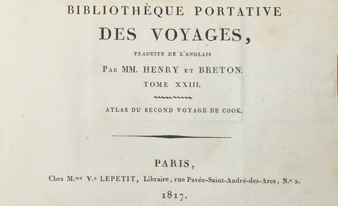
1817 James Cook Antique Atlas, 2nd Voyage Pacific & Antartica - 1 Map 21 Prints
- Title : Atlas Du Second Voyage de Cook...Chez M.Me Lepetit...1817
- Ref #: 91518
- Size: 8vo
- Date : 1817
- Condition: (A) Very Good Condition
Description:
This fine original antique Atlas of Captain James Cooks 2nd Voyage of discovery to the Pacific, The Great South land - Antarctica, translated from the English by M Henry & M Breton, was published by V Lepetit. Paris in 1817 - dated.
This atlas contains 22 (of 27) copper-plate engraved prints & map, listed below, sold as a collection of prints.
The atlas covers have been removed. Pages are generally clean with light aging to borders, overall VG, 8vo, each page size is 7in x 5in (180mm x 125mm)
- Carte des Decouvertes saites dans la Mer Pacifique...Capitaine Cook...1774
2. Isles de Glacee
3. Crombes de mer
4.
5.
6. Coupapow
7.
8. Cimetierre de L Isle d Amesterdam
9. Homme de Lisle de Paques
10. Femme de Lisle de Paques
11. Monumens de Isle de Paques
12. Baie de la Resolution
13. Flotte d'Oparee
14. Cynaimai
15. Ohedidee
16. Ile de Rotterdam
17. Pirogues des Isles des Aimes
18. Debarquement a Erramanga
19. Ile de Tanna
20. Hommes de la Nouvelle Caledonie
21. Femme de la nouvelle Caledone
22. Ornemens et armes de la nouvelle Caledonie
23. Isle des pines Norfolk
24.
25.
26. Canal de Noel
27. Baie de la Possession
Cook's Second Voyage (1772-1775)
Two ships were employed with Cook commanding the Resolution and Captain Tobias Furneaux in charge of the Adventure. The purpose was to circumnavigate the globe as far south as possible to confirm the location of a southern continent. Cook proved that there was no "Terra Australis," which supposedly was located between New Zealand and South America. Cook was convinced, however, that there was land beyond the southern ice fields. In his pursuit of this idea, this expedition was the first European voyage to cross the Antarctic Circle.
Captain James Cook navigator, was born on 27 October 1728 at Marton-in-Cleveland, Yorkshire, England, the son of a Scottish labourer and his Yorkshire wife. He grew up on a farm at Great Ayton, attending the village school, and at 17 was apprenticed to a shopkeeper at Staithes. After eighteen months, with the consent of all concerned, he gave this up for a more enticing apprenticeship of three years under John Walker, a Quaker coal-shipper of Whitby. Here he made some headway with mathematics and navigation and served two years before the mast in the Baltic trade. In 1755 Walker offered him a command, but instead Cook joined H.M.S. Eagle and within a month was master's mate. After two years on the Channel service, he was promoted master of the Pembroke, and in 1758 crossed the Atlantic in her and took part in the siege of Louisburg and the survey of the St Lawrence River that led to the capture of Quebec. Transferred to the Northumberland, he began surveying the coasts of Nova Scotia and Newfoundland, in the winter months at Halifax reading solidly in his chosen subjects.
Back in England late in 1762 he married Elizabeth Batts (1742-1832?) of Shadwell, but soon returned to the Newfoundland survey, in 1764 winning his first command in the Grenville. The acquaintance he made here with the future Admiral Sir Hugh Palliser, then governor of Newfoundland and Labrador, the publication of his Newfoundland charts and his observation of a solar eclipse brought him to the attention of the Royal Society and the Admiralty. Although the society recommended Alexander Dalrymple as leader of the expedition to the South Seas to observe the transit of Venus, the Admiralty chose Cook, promoted him from master to lieutenant and gave him command of the Endeavour Bark, 368 tons. He sailed from Plymouth on 26 August 1768 with a complement of ninety-four, including Joseph Banks and his retinue. By way of Cape Horn, they reached Tahiti on 13 April 1769 and duly made their observations on 3 June, meanwhile charting the islands and collecting natural history specimens.
Cook also had secret instructions to determine the existence of a southern continent propounded by geographical philosophers. Accordingly he sailed for New Zealand in August, circumnavigated the islands, charted its coast and took formal possession. This work finished, Cook decided 'to steer to the Westward until we fall in with the E coast of New Holland'. At 6 p.m. on 19 April 1770 Lieutenant Hicks saw land, and a point at the south-east of the Australian mainland was named after him. Cook sailed north, charting the coast and seeking a harbour where the Endeavour's fouled bottom could be scraped. On 29 April he landed at Stingray Bay, where Banks and his naturalists collected such varied specimens that the anchorage was renamed Botany Bay. After a week they sailed again, making their second landing at Bustard Bay and a third near Cape Townshend. Further north Cook found himself within the Barrier Reef amidst dangerous shoals. Sounding their way and often preceded by the long-boat, they crept north, making two more landings in search of water, but at 10 p.m. on 11 June the Endeavour struck fast on a coral reef at high tide. Ballast, guns and decayed stores were jettisoned; then, two tides later she was hauled off with windlass and anchors, and after three days beached in the Endeavour River. Repairs and gales delayed them for seven weeks but, after rounding and naming Cape York, on 22 August at Possession Island, Cook once more 'hoisted English Coulers' and took possession of the whole eastern coast, later adding the name, New South Wales, in his journal. Satisfied that New Guinea and New Holland were separate islands, he sailed for Batavia, arriving on 11 October. Repairs and refitting delayed his departure until 26 December, and he did not reach England until 13 July 1771.
Not even the modesty of Cook's report could obscure the extent or importance of his achievements. His discoveries, apart from New South Wales, were not new, yet without a chronometer he had charted 5000 miles (8047 km) of coast with unusual accuracy. But he lamented his failure to find the southern continent and pleaded for another opportunity to seek it. He was promoted commander and given charge of an expedition, himself in the Resolution and Tobias Furneaux captain of the Adventure. On this second voyage in 1772-75, Cook circumnavigated the world in high southern latitudes. Its chief importance for Australian discovery was in February and March 1773 when the Adventure, parted from the Resolution by fog and gales, made for the south coast of Van Diemen's Land. Here Furneaux renamed Adventure Bay on Bruny Island, sailed round Tasman Peninsula and up the east coast to Flinders Island, but through bad weather failed to reach Point Hicks before proceeding to rendezvous with the Resolution in New Zealand. On his third voyage Cook, now post-captain and fellow of the Royal Society, visited Adventure Bay himself on 26 January 1777, on his way to New Zealand and Tahiti. He went on to explore the Pacific coasts of North America and Siberia. In November 1778 he was at the Sandwich Islands (Hawaii), where at Kealakekua (Karakakooa) Bay he was killed on 14 February 1779.
Cook's strength was his self-confidence. He drove himself as hard as his men yet they followed him loyally, though they sometimes grumbled at his rules of hygiene and at the diet necessary to prevent scurvy, which were singularly successful in preserving the health of his crews. He was also severe on uncompliant natives whom he met on his voyages, and his readiness to use force contributed to his untimely death. His greatest achievements were negative, for they proved where land was not, but his coastal charting set high standards and many of his discoveries helped to create a second British empire.
General Description:
Paper thickness and quality: - Heavy, stable
Paper color: - off white
Age of map color: -
Colors used: -
General color appearance: -
Atlas size: - 8vo
Imperfections:
Margins: - Age toning
Plate area: - Age toning
Verso: - Age toning
1980 R V Tooley The Mapping of America 1st Edition, Signed
- Title : The Mapping of America
- Ref #: 91439
- Size: 4to
- Date : 1980
- Condition: (A+) Fine Condition
Description:
Signed first edition of R V Tooley's The Mapping of America by RV Tooley, London: Holland Press, 1980, hardcover. Copy #49 from an edition of 300 specially bound copies, Cartographica 2.
Includes numerous black and white maps and an index by Douglas Matthews. A close to near fine copy in three quarter leather binding with marbled paper covered boards and all page edges gilt but with a tiny rub to the spine and some light rubbing to bottom of boards, else fine.
Signed under frontispiece photograph of Tooley.
Ronald Vere Tooley (1898 - 1986) was an English map dealer, an authority on early maps and cartographers, a noted compiler of catalogues on maps, cartography and antiquarian books, author of Maps and Map-makers, and founder of the Map Collectors' Circle which published a series of monographs on historical cartography in the period 1963-1975. He is considered the founder of the antiquarian map trade.
Tooley was born on Michaelmas and adopted the nickname "Mick"
Tooley was born and raised in Islington, London, and educated at the City of London School. Towards the end of World War I he enlisted in the Queen’s Westminster Rifles. After his basic training he left for France and took part in the Battle of Cambrai, where he was one of 120 survivors from an initial force of 400 men. On being demobilised in 1919 and having no definite career plans, he came across an illustrated catalogue of antiquarian books, published by James Tregaskis of Great Russell Street. The idea of working in the bookselling field appealed to him, and armed with a letter of introduction he made the acquaintance of Francis Edwards Ltd., and was summarily employed.
After World War I the book trade enjoyed a time of relative prosperity, but with the Wall Street collapse in 1929, economic depression hit the commercial sector in many countries, the secondhand book trade being no exception. In the 1930s Tooley left Francis Edwards Ltd and opened The Atlas Bookshop, just off Charing Cross Road, and started dealing almost exclusively in antiquarian maps. Between 1932 and 1934 he collaborated with a Mr M. Sinelnikoff of Orion Booksellers Ltd. Sinelnikoff’s passion was old maps, charts and globes, and with Tooley's interest, a fertile conjunction of scholarly minds was created. Tooley had always been interested in Colour Plate books, and in 1935 Batsford published his first book on the subject Some English Books with Coloured Plates. When The Atlas Bookshop closed in 1936 Tooley started work at the Parker Gallery in Albemarle Street - the firm specialising in military and sporting prints as well as old maps. With the outbreak of World War II in 1939 Tooley found work as a telephone operator, but still worked with old books and maps in his spare time.
In 1946 the management of Francis Edwards Ltd, keenly aware of Tooley's considerable business expertise and knowledge of old maps, invited him to rejoin the firm. Here he continued his research, spending long hours in the Map Room of the British Museum. His talents soon led to his being appointed a director of the firm. In 1949 his second book Maps & Map-makers was published, praised as a sound introduction and guide to a complex field, and running to many editions.[3] Tooley retired from Francis Edwards Ltd in 1975 and in 1979 joined Peter Scott and Peter Kalms in setting up a new company R.V.Tooley Ltd, he was joined by his stepson Douglas Adams and in October 1979 his stepson Stephen Luck joined them, first trading at Tring, Hertfordshire and then in the Spring of 1980 33 Museum Street, this company closed in 1982 and became Tooley Adams & Co. Together they developed the firm into one of the leading antique map dealers, supplying maps to dealers, museums and libraries all over the world.
"The Map Collector’s Series" is widely regarded as the greatest of Tooley's achievements. The idea of producing a series of monographs on maps was first discussed in 1960 with Robert Stockwell. The interest generated by this idea was widespread and led to The Map Collector’s Circle being formed in April 1963 under Tooley and David Schrire. The series was acclaimed throughout the world, and seen as an important contribution to cartography. It also led to the founding of the Carta Press, aimed at publishing authoritative works on cartography. The first publication, in 1968, was Maps of the African Continent and Southern Africa, and was followed in 1970 by County Atlases of the British Isles by R.A. Skelton of the Map Room of the British Museum. The Map Collector magazine was started by Tooley in 1977 when the Map Collector’s Circle ceased publishing. Each issue of The Map Collector consisted of articles and information provided by respected authorities, collectors and dealers. (Ref: M&B; Tooley)
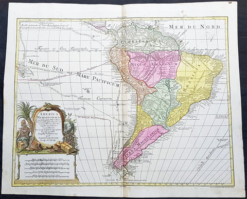
1772 Tobias Lotter Large Antique Map of South America, Magellan, Drake, Le Maire
- Title : America Meridionalis ...Tobiam Conr. Lotter...1772
- Date : 1772
- Size: 25 1/2in x 21in (650mm x 535mm)
- Ref #: 61139
- Condition: (A+) Fine Condition
Description:
This large original beautifully hand coloured copper plate engraved antique map of South America was engraved by Gustav Conrad Lotter in 1772 - dated at the foot of the map - and published by his father Tobias Conrad Lotter.
The map shows the routes of the voyages by various famous explorers to South America including: Magellan (1520), Drake (1577), le Maire & Schouten (1616), Sarmineto (1570) and others. The map also illustrates various river systems and other speculative information about the unexplored interior of the Continent. (Ref: Tooley, M&B)
General Definitions:
Paper thickness and quality: - Heavy and stable
Paper color : - off white
Age of map color: - Original
Colors used: - Blue, pink, red, green, yellow
General color appearance: - Authentic
Paper size: - 25 1/2in x 21in (650mm x 535mm)
Plate size: - 23 1/2in x 19 1/2in (595mm x 495mm)
Margins: - Min 1in (25mm)
Imperfections:
Margins: - None
Plate area: - None
Verso: - None
Background:
In 1494, Portugal and Spain, the two great maritime European powers of that time, on the expectation of new lands being discovered in the west, signed the Treaty of Tordesillas, by which they agreed, with the support of the Pope, that all the land outside Europe should be an exclusive duopoly between the two countries.
The treaty established an imaginary line along a north-south meridian 370 leagues west of the Cape Verde Islands, roughly 46° 37\\\\\\\\\\\\\\\\\\\\\\\\\\\\\\\\\\\\\\\\\\\\\\\\\\\\\\\\\\\\\\\' W. In terms of the treaty, all land to the west of the line (known to comprise most of the South American soil) would belong to Spain, and all land to the east, to Portugal. As accurate measurements of longitude were impossible at that time, the line was not strictly enforced, resulting in a Portuguese expansion of Brazil across the meridian.
Beginning in the 1530s, the people and natural resources of South America were repeatedly exploited by foreign conquistadors, first from Spain and later from Portugal. These competing colonial nations claimed the land and resources as their own and divided it in colonies.
European infectious diseases (smallpox, influenza, measles, and typhus) – to which the native populations had no immune resistance – caused large-scale depopulation of the native population under Spanish control. Systems of forced labor, such as the haciendas and mining industry\\\\\\\\\\\\\\\\\\\\\\\\\\\\\\\\\\\\\\\\\\\\\\\\\\\\\\\\\\\\\\\'s mita also contributed to the depopulation. After this, African slaves, who had developed immunities to these diseases, were quickly brought in to replace them.
The Spaniards were committed to converting their native subjects to Christianity and were quick to purge any native cultural practices that hindered this end; however, many initial attempts at this were only partially successful, as native groups simply blended Catholicism with their established beliefs and practices. Furthermore, the Spaniards brought their language to the degree they did with their religion, although the Roman Catholic Churchs evangelization in Quechua, Aymara, and Guaraní actually contributed to the continuous use of these native languages albeit only in the oral form.
Eventually, the natives and the Spaniards interbred, forming a mestizo class. At the beginning, many mestizos of the Andean region were offspring of Amerindian mothers and Spanish fathers. After independence, most mestizos had native fathers and European or mestizo mothers.
Many native artworks were considered pagan idols and destroyed by Spanish explorers; this included many gold and silver sculptures and other artifacts found in South America, which were melted down before their transport to Spain or Portugal. Spaniards and Portuguese brought the western European architectural style to the continent, and helped to improve infrastructures like bridges, roads, and the sewer system of the cities they discovered or conquered. They also significantly increased economic and trade relations, not just between the old and new world but between the different South American regions and peoples. Finally, with the expansion of the Portuguese and Spanish languages, many cultures that were previously separated became united through that of Latin American.
Guyana was first a Dutch, and then a British colony, though there was a brief period during the Napoleonic Wars when it was colonized by the French. The country was once partitioned into three parts, each being controlled by one of the colonial powers until the country was finally taken over fully by the British.
The European Peninsular War (1807–1814), a theater of the Napoleonic Wars, changed the political situation of both the Spanish and Portuguese colonies. First, Napoleon invaded Portugal, but the House of Braganza avoided capture by escaping to Brazil. Napoleon also captured King Ferdinand VII of Spain, and appointed his own brother instead. This appointment provoked severe popular resistance, which created Juntas to rule in the name of the captured king.
Many cities in the Spanish colonies, however, considered themselves equally authorized to appoint local Juntas like those of Spain. This began the Spanish American wars of independence between the patriots, who promoted such autonomy, and the royalists, who supported Spanish authority over the Americas. The Juntas, in both Spain and the Americas, promoted the ideas of the Enlightenment. Five years after the beginning of the war, Ferdinand VII returned to the throne and began the Absolutist Restoration as the royalists got the upper hand in the conflict.
The independence of South America was secured by Simón Bolívar (Venezuela) and José de San Martín (Argentina), the two most important Libertadores. Bolívar led a great uprising in the north, then led his army southward towards Lima, the capital of the Viceroyalty of Peru. Meanwhile, San Martín led an army across the Andes Mountains, along with Chilean expatriates, and liberated Chile. He organized a fleet to reach Peru by sea, and sought the military support of various rebels from the Vice-royalty of Peru. The two armies finally met in Guayaquil, Ecuador, where they cornered the Royal Army of the Spanish Crown and forced its surrender.
In the Portuguese Kingdom of Brazil, Dom Pedro I (also Pedro IV of Portugal), son of the Portuguese King Dom João VI, proclaimed the independent Kingdom of Brazil in 1822, which later became the Empire of Brazil. Despite the Portuguese loyalties of garrisons in Bahia, Cisplatina and Pará, independence was diplomatically accepted by the crown in Portugal in 1825, on condition of a high compensation paid by Brazil mediatized by the United Kingdom.
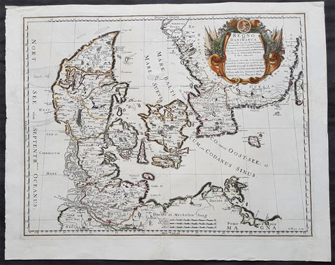
1677 De Rossi Large Original Antique Map of Denmark & Sweden, Schleswig Holstein
- Title : Regno di Danimarca Diuiso nelle Sue due Iutlandie Cioe settentrionale in quattro Diocesi Et Australe, e` il Ducato di...Gio Giacomo De Rossi....L Anno 1677
- Date : 1677
- Size: 22 1/2in x 18in (575mm x 460mm)
- Ref #: 50610
- Condition: (A) Very Good Condition
Description:
A beautiful and quite scarce original 1677 antique map of Denmark and southern Sweden, was engraved in 1677 - dated in the title - and was published in the 1692 edition of de Rossi's world atlas Mercurio Geografico
General Definitions:
Paper thickness and quality: - Heavy and stable
Paper color : - off white
Age of map color: - Early
Colors used: - Yellow, green, blue, pink
General color appearance: - Authentic
Paper size: - 22 1/2in x 18in (575mm x 460mm)
Plate size: - 20 1/2in x 16in (420mm x 405mm)
Margins: - Min 1in (25mm)
Imperfections:
Margins: - Professional repairs to top & bottom margins
Plate area: - Professional repairs to centerfold
Verso: - Repairs as noted
Background:
Before the fifteenth century the people of Southern Europe had little geographical knowledge of the Scandinavian World except from sketchy detail shown in the Catalan Atlas (1375) and on a number of " portolani" embracing Denmark and the southern tip of Norway. It was not until 1427 that a manuscript map prepared about that time by Claudius Clavus (b.1388) a Dane who spent some time in Rome, made available to scholars a tolerable outline of the northern countries and Greenland. That was to remain the best map available for the rest of the century and it was used as the basis for maps of Scandinavia in early printed editions of Ptolemy. Others by Nicolaus Cusanus (1491) and Ehrhard Etzlaub (c. 1492) followed but, needless to say, these are extremely rare; even the later maps by Olaus Magnus and Marcus Jordan, where they have survived at all , are known only by a very few examples. In fact, apart from the rare appearance of an early Ptolemy map, the oldest of Scandinavia which a collector is likely to find are those of Munster's Cosmograhy first published in 1544. In the following centuries the few maps and charts complied in Scandinavia were usually published in Amsterdam, Antwerp, Paris or Nuremberg, the most important maps often being incorporated in the major Dutch, French & German Atlases. (Ref: Tooley; M&B)
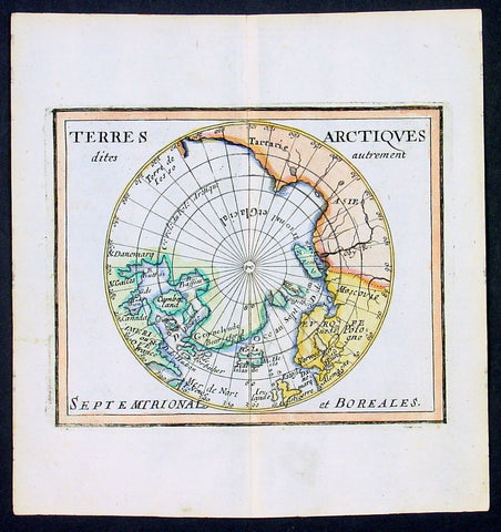
1682 Du Val Original Antique Map of North Pole, North America, Europe, Russia
- Title : Terres Arctiques.. Septemtrional et Boreales.
- Date : 1682
- Size: 6 1/2in x 6in (160mm x 155mm)
- Ref #: 22138
- Condition: (A+) Fine Condition
Description:
This beautifully hand coloured original 1682 antique map of the North Pole by Pierre Du Val was published in his 1682 miniature atlas, 'Géographie Universelle'.Jacques Nicholas Bellindu
General Definitions:
Paper thickness and quality: - Heavy and stable
Paper color : - off white
Age of map color: - Original
Colors used: - Yellow, green, blue, pink
General color appearance: - Authentic
Paper size: - 6 1/2in x 6in (160mm x 155mm)
Plate size: - 5in x 4in (125mm x 100mm)
Margins: - Min 1/2in (12mm)
Imperfections:
Margins: - None
Plate area: - None
Verso: - None
Background:
A driving force for the exploration of the Arctic was the desire of European monarchs to find an alternate trading route to China, via either a Northwest Passage along the coast of North America, or a Northeast Passage along the coast of Siberia. A number of expeditions sought such routes in the 1500-1700s, which resulted in the discovery of much of northern North America, but no viable passage.
In 1524, under the direction of the king of France, Giovanni da Verrazano took the entrance to Hudson River (now New York City) to be the entrance for the passage, and ten years later Jacques Cartier likewise discovered the St. Lawrence estuary. The first Englishman to seek the passage was Martin Frobisher in three voyages up to 60°N between 1576 and 1578. On his first voyage, relations with the natives quickly became hostile, and a prisoner was brought back to England. John Davis followed in 1585, 1586, and 1587 charting the strait west of Greenland that now bears his name.
Financed by the Dutch, in 1609 the Englishman Henry Hudson followed Verrazano's course, and explored the river that now bears his name. The following year he discovered the vast inlet (now called Hudson Bay) beyond Davis Strait. Robert Bylot and navigator William Baffin undertook two expeditions in 1615 and 1616, exploring the north coast of Greenland up to 78°N and then along the Canadian archipelago to Lancaster Sound. Convinced it was only a bay, Baffin concluded that no Northwest Passage existed, and interest in searching for one waned for the next 200 years.
Other explorers were drawn to search for a Northeast Passage connecting the White Sea and Bering Sea. The Dutch navigator William Barents led three expeditions east of Novaya Zemlya, and on the third expedition in 1596 claimed Spitsbergen. From the early 16th century, Russian navigators used shallow draft vessels with reinforced bottoms (kochi) to cross the Kara Sea and explore the Ob and Yenisey rivers. Yermak's Cossacks expanded the Russian presence eastward, crossing the Ural Mountains in 1581. In 1601, Mangazeya town was founded at Taz River between the Ob and Yenisey rivers, and dozens of boats from Pomor lands began annual navigations.
Throughout the first quarter of the 17th century, a great number of merchants, trappers and Cossacks moved east and north, settled East Siberia and explored the northern Siberian coast. In 1610, the Yenisey River was navigated to its northern estuary and the coast to the estuary of the Pyasina was explored. Cape Chelyuskin was overtaken from the west in 1617, Yakutian Cossacks Ivan Rebrov and Ilya Perfilyev headed down to the Lena River estuary and made the first sea voyage to the Yana River in 1633, and in 1639, the Pacific shore was reached by Ivan Moskvitin and his detachment of Cossacks. In a 15-year timespan, all Siberian river estuaries from Khatanga to Kolyma had been discovered and a large part of the Northeast Passage from the White Sea to Kolyma estuary had been covered. Semen Dezhnev traversed the final segment in 1648, leading 90 Cossacks on a journey from the Kolyma to Anadyr Rivers, discovering the strait between Asia and America (proving that they were different continents) and passing the cape which now bears his name.
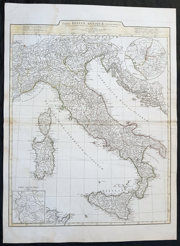
1764 J B D Anville Large Original Antique Map of Italy inset plan of Rome
- Title : Tabula Italiae Antiqua Geographica...MDCCLXIV
- Date : 1764
- Size: 29in x 21in (740mm x 535mm)
- Ref #: 92297
- Condition: (A+) Fine Condition
Description:
This large finely engraved and highly detailed original antique map of Italy by Jean Baptiste Bourguignon D\'Anville was engraved in 1764 - dated in the tile cartouche - and was published in Jean-Baptiste Bourguinon D\'Anville\'s large elephant folio atlas Atlas Generale.
General Definitions:
Paper thickness and quality: - Heavy and stable
Paper color : - off white
Age of map color: - Original
Colors used: - Yellow, green, pink, blue
General color appearance: - Authentic
Paper size: - 29in x 21in (740mm x 535mm)
Plate size: - 25in x 20in (635mm x 510mm)
Margins: - Min 1/2in (12mm)
Imperfections:
Margins: - Age toning along centerfold
Plate area: - Age toning along centerfold
Verso: - Age toning along centerfold
Background:
Since classical times, ancient Phoenicians, Carthaginians and Greeks established settlements in the south of Italy, with Etruscans and Celts inhabiting the centre and the north of Italy respectively and various ancient Italian tribes and Italic peoples dispersed throughout the Italian Peninsula and insular Italy. The Italic tribe known as the Latins formed the Roman Kingdom, which eventually became a republic that conquered and assimilated other nearby civilisations. Ultimately the Roman Empire emerged as the dominant power in the Mediterranean basin, conquering much of the ancient world and becoming the leading cultural, political and religious centre of Western civilisation. The legacy of the Roman Empire is widespread and can be observed in the global distribution of civilian law, republican governments, Christianity and the Latin script.
During the Early Middle Ages Italy suffered sociopolitical collapse amid calamitous barbarian invasions, but by the 11th century, numerous rival city-states and maritime republics, mainly in the northern and central regions of Italy, rose to great prosperity through shipping, commerce and banking, laying down the groundwork for modern capitalism.These mostly independent statelets, acting as Europe\'s main spice trade hubs with Asia and the Near East, often enjoyed a greater degree of democracy and wealth in comparison to the larger feudal monarchies that were consolidating throughout Europe at the time, though much of central Italy remained under the control of the theocratic Papal States, while Southern Italy remained largely feudal until the 19th century, partially as a result of a succession of Byzantine, Arab, Norman and Spanish conquests of the region.
The Renaissance began in Italy and spread to the rest of Europe, bringing a renewed interest in humanism, science, exploration and art. Italian culture flourished at this time, producing famous scholars, artists and polymaths such as Leonardo da Vinci, Galileo, Michelangelo and Machiavelli. Italian explorers such as Marco Polo, Christopher Columbus, Amerigo Vespucci and Giovanni da Verrazzano discovered new routes to the Far East and the New World, helping to usher in the European Age of Discovery. Nevertheless, Italy\'s commercial and political power significantly waned with the opening of the Atlantic trade route and the route to the Indian Ocean via the Cape of Good Hope, both of which bypassed the Mediterranean. Furthermore, the Italian city-states constantly engaged one another in bloody warfare, culminating in the Italian Wars of the 15th and 16th centuries that left them exhausted, with no one emerging as a dominant power. The weakened Italian sovereigns soon fell victim to conquest by European powers such as France, Spain and Austria.
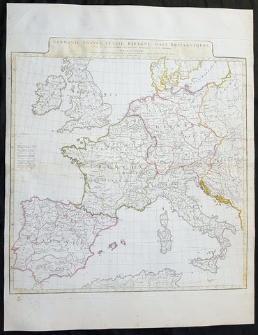
1771 J B D Anville Large Original Antique Map of Western Europe & Britain
- Title : Germanie, France, Italie, Espagne, Isles Britanniques...MDCCLXXI
- Size: 25 1/2in x 20in (650mm x 525mm)
- Ref #: 92305
- Date : 1771
- Condition: (A) Very Good Condition
Description:
This large finely engraved and highly detailed original antique map of Western Europe and The British Isles by Jean Baptiste Bourguignon D\'Anville was engraved in 1771 - dated in the tile cartouche - and was published in Jean-Baptiste Bourguinon D\'Anville\'s large elephant folio atlas Atlas Generale.
General Definitions:
Paper thickness and quality: - Heavy and stable
Paper color : - off white
Age of map color: - Original
Colors used: - Yellow
General color appearance: - Authentic
Paper size: - 25 1/2in x 20in (650mm x 525mm)
Plate size: - 21in x 19 1/2in (535mm x 495mm)
Margins: - Min 1/2in (12mm)
Imperfections:
Margins: - Creasing along centerfold
Plate area: - Creasing along centerfold
Verso: - Creasing along centerfold