On Sale (5)
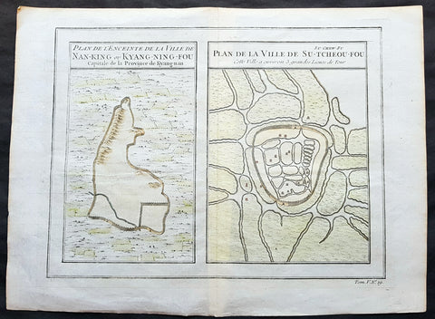
1755 Prevost & Schley Antique Map, View of Nanking or Nanjing in Jiangsu, China
- Title: Plan De L Enceinte de la Ville De Nan-King ou Kyang-Ning-Fou Capitale de la Province de Kyang-nan; Plan de la Ville De Su-Tcheou-Fou
- Date: 1755
- Condition : (A+) Fine Condition
- Ref: 15844
- Size: 13 1/2in x 10in (345mm x 255mm)
Description:
This fine, original copper-plate engraved antique map a birds-eye view of the walled cities of Nanjing & Zhenzhou, in the Jiangsu Province of China by Jakob van Schley in 1755 was published in Antoine François Prevosts 15 volumes of Histoire Generale des Voyageswritten by Prevost & other authors between 1746-1790.
Nanjing formerly romanized as Nanking and Nankin, is the capital of Jiangsu province of the People\'s Republic of China and the second largest city in the East China region, with an administrative area of 6,600 km2 (2,500 sq mi) and a total population of 8,270,500.
Situated in the Yangtze River Delta region, Nanjing has a prominent place in Chinese history and culture, having served as the capital of various Chinese dynasties, kingdoms and republican governments dating from the 3rd century to 1949, and has thus long been a major center of culture, education, research, politics, economy, transport networks and tourism, being the home to one of the world\'s largest inland ports.
Nanjing, one of the nation\'s most important cities for over a thousand years, is recognized as one of the Four Great Ancient Capitals of China. It has been one of the world\'s largest cities, enjoying peace and prosperity despite wars and disasters. Nanjing served as the capital of Eastern Wu, one of the three major states in the Three Kingdoms period (211–280); the Eastern Jin and each of the Southern Dynasties (Liu Song, Southern Qi, Liang and Chen), which successively ruled southern China from 317–589; the Southern Tang, one of the Ten Kingdoms (937–76); the Ming dynasty when, for the first time, all of China was ruled from the city (1368–1421);[15] and the Republic of China (1927–37, 1945–49) prior to its flight to Taiwan during the Chinese Civil War. The city also served as the seat of the rebel Taiping Heavenly Kingdom (1851–64) and the Japanese puppet regime of Wang Jingwei (1940–45) during the Second Sino-Japanese War. It suffered appalling atrocities in both conflicts, including the Nanjing Massacre.
General Definitions:
Paper thickness and quality: - Heavy and stable
Paper color : - off white
Age of map color: - Early
Colors used: - Yellow, green, orange
General color appearance: - Authentic
Paper size: - 13 1/2in x 10in (345mm x 255mm)
Plate size: - 11 1/2in x 9in (295mm x 230mm)
Margins: - Min 1/2in (12mm)
Imperfections:
Margins: - None
Plate area: - None
Verso: - None
Background:
One of Antoine Francois Prevosts monumental undertakings was his history of exploration & discovery in 15 volumes titledHistoire Générale des Voyages written between 1746-1759 and was extended to 20 volumes after his death by various authors.
The 20 volumes cover the early explorations & discoveries on 3 continents: Africa (v. 1-5), Asia (v. 5-11), and America (v. 12-15) with material on the finding of the French, English, Dutch, and Portugese.
A number of notable cartographers and engravers contributed to the copper plate maps and views to the 20 volumes including Nicolas Bellin, Jan Schley, Chedel, Franc Aveline, Fessard, and many others.
The African volumes cover primarily coastal countries of West, Southern, and Eastern Africa, plus the Congo, Madagascar, Arabia and the Persian Gulf areas.
The Asian volumes cover China, Korea, Tibet, Japan, Philippines, and countries bordering the Indian Ocean.
Volume 11 includes Australia and Antarctica.
Volumes 12-15 cover voyages and discoveries in America, including the East Indies, South, Central and North America.
Volumes 16-20 include supplement volumes & tables along with continuation of voyages and discoveries in Russia, Northern Europe, America, Asia & Australia.
Jakob van der Schley aka Jakob van Schley (1715 - 1779) was a Dutch draughtsman and engraver. He studied under Bernard Picart (1673-1733) whose style he subsequently copied. His main interests were engraving portraits and producing illustrations for \\\"La Vie de Marianne\\\" by Pierre Carlet de Chamblain de Marivaux (1688-1763) published in The Hague between 1735 and 1747.
He also engraved the frontispieces for a 15-volume edition of the complete works of Pierre de Brantôme (1540-1614), Oeuvres du seigneur de Brantôme, published in The Hague in 1740.
He is also responsible for most of the plates in the Hague edition of Prévosts Histoire générale des voyages. (Ref: Tooley; M&B)
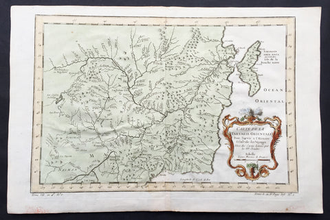
1760 Bellin Antique Map of Manchurian Empire, Mongolia, China, Sakhalin Islands
- Title: Carte De la Tartarie Orientale...P.P Jesuits
- Date: 17560
- Condition : (A+) Fine Condition
- Ref: 60927
- Size: 15in x 10in (380mm x 255mm)
Description:
This fine, original copper-plate engraved antique map of old Manchurian Empire - now NE China, Mongolia & Russia stretching from Beijing to the Sakhalin Islands by Jacques Nicolas Bellin in 1760 was published in Antoine François Prevosts 15 volumes of Histoire Generale des Voyages written by Prevost & other authors between 1746-1790.
General Definitions:
Paper thickness and quality: - Heavy and stable
Paper color : - off white
Age of map color: - Early
Colors used: - Green, yellow, red
General color appearance: - Authentic
Paper size: - 15in x 10in (380mm x 255mm)
Plate size: - 13in x 9in (330mm x 230mm)
Margins: - Min 1/2in (6mm)
Imperfections:
Margins: - None
Plate area: - Folds as issued
Verso: - None
Background:
One of Antoine Francois Prevosts monumental undertakings was his history of exploration & discovery in 15 volumes titledHistoire Générale des Voyages written between 1746-1759 and was extended to 20 volumes after his death by various authors.
The 20 volumes cover the early explorations & discoveries on 3 continents: Africa (v. 1-5), Asia (v. 5-11), and America (v. 12-15) with material on the finding of the French, English, Dutch, and Portugese.
A number of notable cartographers and engravers contributed to the copper plate maps and views to the 20 volumes including Nicolas Bellin, Jan Schley, Chedel, Franc Aveline, Fessard, and many others.
The African volumes cover primarily coastal countries of West, Southern, and Eastern Africa, plus the Congo, Madagascar, Arabia and the Persian Gulf areas.
The Asian volumes cover China, Korea, Tibet, Japan, Philippines, and countries bordering the Indian Ocean.
Volume 11 includes Australia and Antarctica.
Volumes 12-15 cover voyages and discoveries in America, including the East Indies, South, Central and North America.
Volumes 16-20 include supplement volumes & tables along with continuation of voyages and discoveries in Russia, Northern Europe, America, Asia & Australia.

1755 Prevost & Schley Antique City Map of Hangzhou in Zhejiang Province, China
- Title: Plan De la Ville de Hang-Tcheou-Fou ou Hang chew Fu Capitale de la Province de Che-Kiang
- Date: 1755
- Condition : (A+) Fine Condition
- Ref: 25812
- Size: 15in x 10in (385mm x 255mm)
Description:
This fine, original copper-plate engraved antique map a plan of the city of Hangzhou (here Hang Chew Fu) in the Zhejiang province of China by Jakob van Schley in 1755 - after Jean-Baptiste Du Halde - was published in Antoine François Prevosts 15 volumes of Histoire Generale des Voyages written by Prevost & other authors between 1746-1789.
Jean-Baptiste Du Halde, born in Paris on 1 February 1674 and died 18 August 1743, was a French Jesuit historian specializing in China. He did not travel to China, but collected seventeen Jesuit missionaries\\\' reports and provided an encyclopedic survey of the history, culture and society of China and Chinese Tartary, that is, Manchuria.
General Definitions:
Paper thickness and quality: - Heavy and stable
Paper color : - off white
Age of map color: - Original
Colors used: - Yellow, green, blue, pink
General color appearance: - Authentic
Paper size: - 10in x 7 1/2in (255mm x 190mm)
Plate size: - 10in x 7 1/2in (255mm x 190mm)
Margins: - Min 1/2in (12mm)
Imperfections:
Margins: - None
Plate area: - None
Verso: - None
Background:
Hangzhou romanization Hang-chou, conventional Hangchow, city and capital of Zhejiang sheng (province), China. The city is located in the northern part of the province on the north bank of the Qiantang River estuary at the head of Hangzhou Bay. It has water communications with the interior of Zhejiang to the south, is the southern terminus of the Grand Canal, and is linked to the network of canals and waterways that cover the Yangtze River (Chang Jiang) delta area to the north. The city stands at the eastern foot of a scenic range of hills, the Tianmu (“Eye of Heaven”) Mountains, and on the shore of the famous Xi (West) Lake, celebrated in poetry and paintings for its beauty and a favourite imperial retreat.
The county of Qiantang was first established at this site under the Qin dynasty (221–207 BCE) but did not start developing until the 4th and 5th centuries CE, when the Yangtze River delta area began to be settled. A prefecture named Hangzhou was created there in 589, during the Sui dynasty (581–618), which is the source of the city’s name. It became a major local centre with the completion of the Jiangnan Canal (then the southern section of the Grand Canal) in 609. During the Ten Kingdoms (Shiguo) period (907–960), Hangzhou was the capital of the state of Wu-Yue. In the later Song period (960–1279), northern China fell to the Jin (Juchen) dynasty (1115–1234); from 1127 the Song rulers were confined to southern China, and they made Hangzhou (then known as Lin’an) their capital. A centre of commerce, it was visited in the late 13th century by the Venetian traveler Marco Polo, who called it Kinsai, or Quinsay; it then had an estimated population of 1 million to 1.5 million.
Although it never again reached the peak of importance that it had achieved as capital of the Nan (Southern) Song, Hangzhou remained important. Under the Ming (1368–1644) and Qing (1644–1911/12) dynasties, it was a superior prefecture, in addition to being the provincial capital of Zhejiang. It became immensely wealthy, being at the centre of a fertile rice-growing area as well as being the site of the most important silk industries in China. It also was famous as a centre of culture, producing numerous writers, painters, and poets. Its importance as a port dwindled, however, as Hangzhou Bay gradually silted up and as its outport, Ganpu, became useless. From the 14th century its trade gradually shifted to Ningbo to the southeast on the southern shore of the bay and, in the 19th century, to the new city of Shanghai, some 100 miles (160 km) to the northeast at the mouth of the Yangtze. In 1861, during the Taiping Rebellion (1850–64), the city fell to the rebels and suffered severe damage.
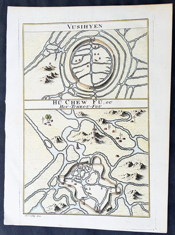
1755 Prevost Antique Plans Cities of Jinhua & Pinghu in Zhejiang Province, China
- Title: Vusihyen; Hou-Tcheou-Fou
- Date: 1747
- Condition : (A+) Fine Condition
- Ref: 01-9784
- Size: 10in x 8in (255mm x 205mm)
Description:
This fine, original copper-plate engraved antique map, plans of the cities of Jinhua & Pinghu in the eastern Chinese province of Zhejiang by Jakob van Schley in 1755 - after Jean-Baptiste Du Halde - was published in Antoine François Prevosts 15 volumes of Histoire Generale des Voyages written by Prevost & other authors between 1746-1789.
Jean-Baptiste Du Halde, born in Paris on 1 February 1674 and died 18 August 1743, was a French Jesuit historian specializing in China. He did not travel to China, but collected seventeen Jesuit missionaries\\\' reports and provided an encyclopedic survey of the history, culture and society of China and Chinese Tartary, that is, Manchuria.
General Definitions:
Paper thickness and quality: - Heavy and stable
Paper color : - off white
Age of map color: - Original
Colors used: - Yellow, green, blue, pink
General color appearance: - Authentic
Paper size: - 10in x 7 1/2in (255mm x 190mm)
Plate size: - 10in x 7 1/2in (255mm x 190mm)
Margins: - Min 1/2in (12mm)
Imperfections:
Margins: - None
Plate area: - None
Verso: - None
Background:
Zhejiang formerly romanized as Chekiang, is an eastern coastal province of China. Zhejiang is bordered by the Jiangsu province and the Shanghai municipality to the north, the Anhui province to the northwest, the Jiangxi province to the west, and the Fujian province to the south. To the east is the East China Sea, beyond which lies the Ryukyu Islands of Japan.
Zhejiang was finally conquered by the Mongols in the late 13th century who later established the short lived Yuan Dynasty.
The Ming dynasty, which drove out the Mongols in 1368, finally established the present day province of Zhejiang with its borders having little changes since this establishment.
As in other coastal provinces, number of fortresses were constructed along the Zhejiang coast during the early Ming to defend the land against pirate incursions. Some of them have been preserved or restored, such as Pucheng in the south of the province (Cangnan County).
Under the late Ming dynasty and the Qing dynasty that followed it, Zhejiang\'s ports were important centers of international trade.
In 1727 the to-min or \'idle people\' of Cheh Kiang province (a Ningpo name still existing), the yoh-hu or \'music people\' of Shanxi province, the si-min or \'small people\' of Kiang Su (Jiangsu) province, and the Tanka people or \'egg-people\' of Canton (to this day the boat population there), were all freed from their social disabilities, and allowed to count as free men. Cheh Kiang is another romanization for Zhejiang. The Duomin are a caste of outcasts in this province.
During the First Opium War, the British navy defeated Eight Banners forces at Ningboand Dinghai. Under the terms of the Treaty of Nanking, signed in 1843, Ningbo became one of the five Chinese treaty ports opened to virtually unrestricted foreign trade. Much of Zhejiang came under the control of the Taiping Heavenly Kingdom during the Taiping Rebellion, which resulted in a considerable loss of life in the north-western and central parts of the province, sparing the rest of Zhejiang from the disastrous depopulation that occurred. In 1876, Wenzhou became Zhejiang\'s second treaty port. Jianghuai Mandarin speakers later came to settle in these depopulated regions of northern Zhejiang.
Jinhua is a prefecture-level city in central Zhejiang province in eastern China. It borders the provincial capital of Hangzhou to the northwest, Quzhou to the southwest, Lishui to the south, Taizhou to the east, and Shaoxing to the northeast.
The history of Jinhua dates back to the 2nd century BC, when it was a county subordinate to Shaoxing. It was given the name Jinhua under the Sui dynasty in AD 598 and later became the seat of a prefecture. The present city and its walls date to the time of the Mongol emperors in 1352.
The most famous native of Jinhua is Huang Chuping, a Daoist holy man of the 4th century and reputed immortal whose descendants still live in the area. Wuyang Shan (Reclining Sheep Mountain) is said to be a sheep which was turned to stone by Huang, a trick which he learned through his years of diligently studying Daoism.
Economically Jinhua has always prospered from its position as the regional collecting and processing center for agricultural and forestry products (chiefly rice and bamboo). It is currently the second most important grain producing area in Zhejiang. In 1985 Jinhua was promoted to City status, and now is responsible for administering four cities, four counties and a district. Animals raised there include dairy cattle, meat hogs (for the production of Jinhua ham, a famous local product for 900 years) and honeybees. Jinhua\'s industrial sector has developed more recently, producing machinery, metallurgy, pharmaceuticals, building supplies and electrical and electronic equipment.
The Tang dynasty painter Guan Xiu (Kuan-hsiu) was born in Jinhua. He is known for his paintings of Buddhist holy men.
There are numerous scenic and historical sites in the Jinhua region, including many places associated with the Immortal Huang, and a palace of the Dukes of the Taiping Heavenly Kingdom.
Pinghu is a county-level city in northeast Zhejiang Province, just outside Shanghai. It sits next to the East China Sea and the north shore of Hangzhou Bay. Prior to the Ming Dynasty, Pinghu was part of Haiyan County. In 1430 Pinghu County was established. In 1991 Pinghu became a county-level city under the administration of the prefecture-level city of Jiaxing.
Zhapu, the site of a deepwater harbor, was the principal site of China\'s foreign trade with Korea and Japan during the 18th and 19th century.
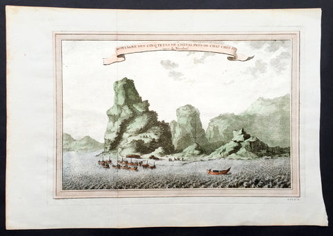
1750 Prevost & Nieuhoff Antique Print View of the Zoushan Archip. Zhejiang China
- Title: Montagne Des Cinq Tetes De Cheval Pres De Chau Cheu Fu
- Date: 1747
- Condition : (A+) Fine Condition
- Ref: 15850
- Size: 14in x 10in (355mm x 255mm)
Description:
This fine original copper-plate engraved antique print a view of the Islands of Zoushan in the in north-eastern Zhejiang Province of eastern China was engraved by Jakob van Schley - after Johannes Nieuhoff - and was published in Antoine François Prevosts 15 volumes of Histoire Generale des Voyageswritten by Prevost & other authors between 1746-1790.
Johannes Nieuhoff (1618-72) was a Dutch diplomat and adventurer, who was perhaps the most widely traveled individual of the seventeenth-century. His experiences included important expeditions to various locations in Brazil, Africa, India, Indonesia, and China. From 1655-57, Nieuhoff made an epic 2,400 trek through China, from Canton to Beijing.
During his Chinese expedition he made numerous drawings of the sites he encountered, including the port town of Chau Cheu Fu in the southern province of Guandong, which was the basis for the present print. Nieuhoff’s important written account, along with engravings of his drawings was first published as Legatio batavica ad magnum Tartariæ chamum Sungteium, modernum Sinæ imperatorem (Amsterdam, 1668). His illustrations proved to be highly influential, as they did much to spawn the genre of chinoiserie in European art and design.
General Definitions:
Paper thickness and quality: - Heavy and stable
Paper color : - off white
Age of map color: - Ewarly
Colors used: - Green, yellow, pink
General color appearance: - Authentic
Paper size: - 14in x 10in (365mm x 250mm)
Plate size: - 12in x 8in (305mm x 205mm)
Margins: - Min 1/2in (12mm)
Imperfections:
Margins: - None
Plate area: - Folds as issued
Verso: - None
Background:
One of Antoine Francois Prevosts monumental undertakings was his history of exploration & discovery in 15 volumes titledHistoire Générale des Voyages written between 1746-1759 and was extended to 20 volumes after his death by various authors.
The 20 volumes cover the early explorations & discoveries on 3 continents: Africa (v. 1-5), Asia (v. 5-11), and America (v. 12-15) with material on the finding of the French, English, Dutch, and Portugese.
A number of notable cartographers and engravers contributed to the copper plate maps and views to the 20 volumes including Nicolas Bellin, Jan Schley, Chedel, Franc Aveline, Fessard, and many others.
The African volumes cover primarily coastal countries of West, Southern, and Eastern Africa, plus the Congo, Madagascar, Arabia and the Persian Gulf areas.
The Asian volumes cover China, Korea, Tibet, Japan, Philippines, and countries bordering the Indian Ocean.
Volume 11 includes Australia and Antarctica.
Volumes 12-15 cover voyages and discoveries in America, including the East Indies, South, Central and North America.
Volumes 16-20 include supplement volumes & tables along with continuation of voyages and discoveries in Russia, Northern Europe, America, Asia & Australia.
Jakob van der Schley aka Jakob van Schley (1715 - 1779) was a Dutch draughtsman and engraver. He studied under Bernard Picart (1673-1733) whose style he subsequently copied. His main interests were engraving portraits and producing illustrations for \"La Vie de Marianne\" by Pierre Carlet de Chamblain de Marivaux (1688-1763) published in The Hague between 1735 and 1747.
He also engraved the frontispieces for a 15-volume edition of the complete works of Pierre de Brantôme (1540-1614), \"Oeuvres du seigneur de Brantôme\", published in The Hague in 1740.
He is also responsible for most of the plates in the Hague edition of Prévost\'s Histoire générale des voyages. (Ref: Tooley; M&B)