On Sale (50)
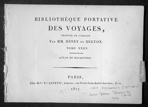
1817 Lord Macartney Antique Atlas of Travels in China in 1794 - 22 Illustrations
- Title: Bibliotheque Portative Des Voyages Traduite De L Anglais Par MM. Henry et Breton Tome XXV - 1817
- Date: 1817
- Condition: (A+) Fine Condition
- Ref : MACTP
- Size: 8vo
Description:
This fine original antique French edition Atlas of the travels of Ambassador Lord Macartney travels in China between 1792 & 1794 was translated and published in Paris by M Henry & Breton in the 1817 - dated - edition of Biblio Portative Des Voyages Traduite De L Anglais Par MM. Henry et Breton Tome XXXV (Portable Travel Library. Translated from the English by MM Henry and Breton Volume 35)
General Description:
Paper thickness and quality: - Heavy and stable
Paper color: - off white
Age of map color: -
Colors used: -
General color appearance: -
Page size: - 7in x 5in (180mm x 125mm)
Imperfections:
Margins: - Light age toning
Plate area: - None
Verso: - None
The atlas covers have been removed with front title page Pages are generally clean with light aging to borders, overall VG, 8vo, each page size is 7in x 5in (180mm x 125mm)
This atlas contains 22 B&W copper-plate engraved prints, listed below.
1. Lord Macartney
2. Arbe a pain de Singe (Monkey Tree)
3. Feuille de Nopal avec Cochenille qui s y Nourit
4. Barque Cochinchinoise (Chinese Barge)
5. Mandarin de Curon
6. Insects qui produisent la Cire de la Cochinchine (Insects that produce the wax of the Cochin China)
7. Maniere de lever les Filets (Net fishing)
8. Pieds des Dames Chinoisec (feet of Chinese Ladies)
9. Chaise a Porteurs (Chair Porters)
10. Maniere de transporter les Fardeaux (Carrying freight)
12. Vue de la Grande Muraille de la Chinese (Great Wall of China)
13. Portrait de l Empereur Cohien Long
14. Bourse et Sceptre de L Empereur (Money & Sceptre of Emperor)
15. Fondateur de l Empire Chinois (Founder of Chinese Empire)
16. Maniere de elever L Eau (Water irrigation)
17. Charrue Chinoise (Plough)
18. Pecheurs portant leur canot et les Oiseaux avec les quels ils prennent le poisson (Using ducks to catch fish)
19. Maniere de degager le Riz de sa pellicule (Rice farming)
20. Cha-wha ou Camellia sesanqua (Camilla flower)
21. Pompe a Chaine (Irrigation)
22. Grotte du Camoens...
Sir George, Earl Macartney, was born at Lissanoure, in the northern part of the County of Antrim, 14th May 1737. Having passed through Trinity College, he entered the Middle Temple, made an extended tour of Europe (becoming acquainted with Rousseau and other persons of eminence), and shortly after his return home in 1764, was, through an intimacy with Lord Holland, appointed a special envoy to negotiate a commercial treaty with Russia. His biographer says: "His knowledge of European politics alone fitted him for the undertaking; but a graceful person, with great suavity of manners, a conciliating disposition, and winning address, were considered as no slight recommendations at a female court, where such accomplishments, it was fair to conclude, might work their way, when great and unaccommodating talents alone would prove ineffectual."
From September 1792 to September 1794, he spent abroad as ambassador to China. The country was then little known, and Lord Macartney's published account of his embassy long continued the standard book of information on Chinese matters. Commenting on his mission, a writer says: "The amount of the benefit gained by this first diplomatic communication on the part of England with the Court of Pekin has been matter of dispute; but it is generally agreed that no other person could have accomplished more than was done by Lord MaCartney, whose conduct at least was well calculated to impress the subjects of the Celestial Empire with a respect for the country which he represented."[97] In 1795 he was sent on a confidential mission to Italy; and from November 1796 to November 1798 he was Governor of the Cape of Good Hope, then newly captured from the Dutch. "There is no praise," says Lord Melville, "to which he is not entitled on the score of his government of the Cape." All his nerve and tact were called forth in 1797 by an attempted mutiny of the British fleet in Simon's Bay, following the news of the mutiny at the Nore.
Impaired health obliged him to give up this, his last official post, and return home. The Union gave him unbounded satisfaction: writing during the negotiations, he said: "I bow with admiration and respect to those by whose wisdom this great and important object has been brought so near to its completion. Considering many things that have happened in my time, painful to recollect and invidious to mention, I little imagined to see this happy day. Thank God! I have seen it. I thank the Father of all mercies that he has been graciously pleased to prolong my days to this auspicious period. The measure before us has my dying voice. It will annihilate the vain hopes of a vain insidious foe from without, and, I trust, will contribute to defeat the projects of a dark and treacherous enemy within." His last years were passed in retirement at Chiswick; his enjoyment of the society of a large circle of eminent men being lessened by severe sufferings from gout. He died, childless, 31st March 1806, aged 68, and was buried at Chiswick. In 1792 he had been created a Viscount; in 1794 an Earl; and in 1796 a British peer. His features were regular and well proportioned, his countenance open, placid, and agreeable. He possessed all the dignity of the " old school," without its stiffness, and retained it in his dress, which he did not materially alter for the last forty years of his life. (Ref Clancy; Tooley; M&B)
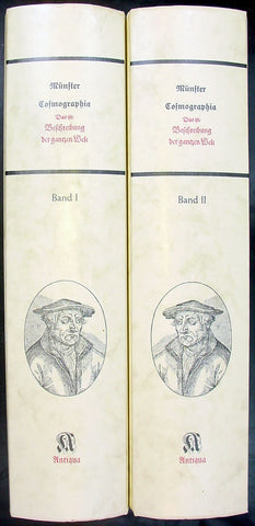
Sebastian Munster Reproduction 2 vol of Cosmographia
- Title: Munster Cosmographia
- Date: 1988
- Condition : (A+) Fine Condition
- Ref: Cosmo1
- Size: Folio
Description:
Two volume 1988 reprint of the 1628 edition of Sebastian Munster's Cosmographia Basel, Beyden Henripetrinischen. Until 1578, the editions of the Cosmographia were published by Munster's stepson, Heinrich Petri (1508 - 1579). Thereafter they were published by the latters son, Sebastian Petri.
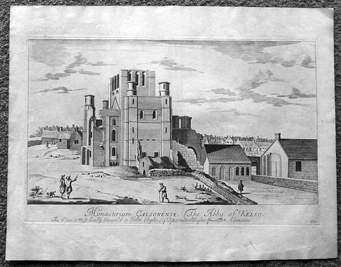
1718 Slezer Antique Print View of Kelso Abby & Township, Scotland
- Title : The Abby of Kelso
- Date : 1718
- Ref # : 24953
- Size : 18 ½in x 14 ½in (470mm x 360mm)
- Condition: (A+) Fine
Description:
This fine beautifully hand coloured original antique print a view of Kelso Abby & Kelso Town, Scotland was published in the 1718 edition of John Slezer's 'Theatrum Scotiae'.
Kelso Abbey is a ruined Scottish abbey in Kelso, Scotland. It was founded in the 12th century by a community of Tironensian monks first brought to Scotland in the reign of Alexander I. It occupies ground overlooking the confluence of the Tweed and Teviot waters, the site of what was once the Royal Burgh of Roxburgh and the intended southern centre for the developing Scottish kingdom at that time. Kelso thus became the seat of a pre-eminently powerful abbacy in the heart of the Scottish Borders.
In the 14th century, Roxburgh became a focus for periodic attack and occupation by English forces and Kelso's monastic community survived a number of fluctuations in control over the area, restoring the abbey infrastructure after episodes of destruction and ultimately retaining Scottish identity. From 1460 onwards, life for the abbey probably grew more settled, but came once again under attack in the early sixteenth century. By the mid-century, through a turbulent combination of events, the abbey effectively ceased to function and the building fell into ruin.
Although the site of Kelso Abbey has not been fully excavated in modern times, evidence suggests that it was a major building with two crossings. The only remains standing today are the west tower crossing and part of the infirmary. The massive design and solid romanesque style of the tower indicate a very large building of formidable, semi-military construction and appearance, evidence of the importance with which Roxburgh was regarded when the abbacy was at the height of its power.
This is an important and rare print as Slezer s Theatrum Scotiae is one of the earliest records of early Scottish towns & major buildings. (Ref: Tooley; M&B)
General Description:
Paper thickness and quality: - Heavy and stable
Paper color: - off white
Age of map color: -
Colors used: -
General color appearance: -
Paper size: - 18 ½in x 14 ½in (470mm x 360mm)
Plate size: - 16 ½in x 11in (420mm x 275mm)
Margins: - Min 1in (25mm)
Imperfections: Margins: - Light age toning
Plate area: - Light age toning
Verso: - Light age toning
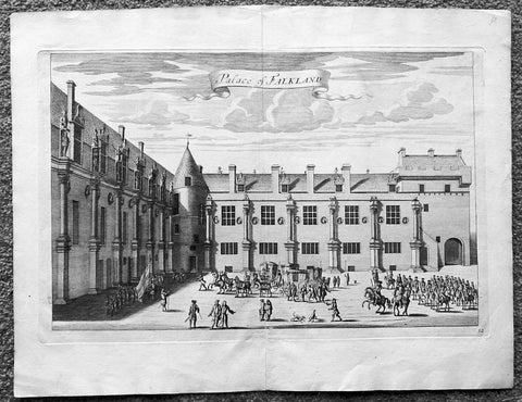
1718 Slezer Antique Print View of Falkland Palace, Fife, Scotland
- Title : Palace of Falkland
- Date : 1718
- Ref # : 24958
- Size : 18 ½in x 14 ½in (470mm x 360mm)
- Condition: (A+) Fine
Description:
This fine beautifully hand coloured original antique print a view of the internal courtyard of Falkland Palace, home of the Scottish Kings - was published in the 1718 edition of John Slezer's 'Theatrum Scotiae'.
Falkland Palace in Falkland, Fife, Scotland, is a former royal palace of the Scottish Kings. The Scottish Crown acquired Falkland Castle from MacDuff of Fife in the 14th century. In 1402 Robert Stewart, 1st Duke of Albany imprisoned his nephew David Stewart, Duke of Rothesay, the eldest son of King Robert III of Scotland, at Falkland. The incarcerated Duke eventually died there from neglect and starvation. Albany was exonerated from blame by Parliament, but suspicions of foul play persisted, suspicions which never left Rothesay's younger brother the future James I of Scotland, and which would eventually lead to the downfall of the Albany Stewarts. John Debrett, writing in 1805, was in no doubt of Duke Robert's motives and guilt. This Robert, Duke of Albany, having obtained the entire government from his brother, King Robert, he caused the Duke of Rothesay to be murdered, thinking to bring the Crown into his own family; but to avoid the like fate, King Robert resolved to send his younger son James, to France, then about nine years old, who being sea-sick, and forced to land on the English coast ... was detained a captive in England eighteen years. At these misfortunes King Robert died of grief in 1406. Between 1501 and 1541 Kings James IV and James V of Scotland transformed the old castle into a beautiful royal palace: with Stirling Castle it was one of only two Renaissance palaces in Scotland. To address the poor state of the garden and park, James V appointed a new Captain and Keeper, William Barclay, Master of Rhynd, in March 1527. Ten years later, James V extended his father's buildings in French renaissance style. He died at Falkland in December 1542 after hearing that his wife had given birth to a daughter—Mary, Queen of Scots. Falkland became a popular retreat with all the Stewart monarchs. They practised falconry there and used the vast surrounding forests for hawking and for hunting deer. Wild boar, imported from France, were kept in the Park, within a fence made by the Laird of Fernie. Nearby Myres Castle is the hereditary home of the Royal Macers and Sergeants at Arms who served Falkland Castle since at least the sixteenth century. John Scrimgeour of Myres supervised building at the Palace from 1532 to 1563. After the Union of the Crowns (1606), James VI and I, Charles I, and Charles II all visited Falkland. A fire partially destroyed the palace during its occupation by Cromwell's troops and it quickly fell into ruin.
This is an important and rare print as Slezer s Theatrum Scotiae is one of the earliest records of early Scottish towns & major buildings. (Ref: Tooley; M&B)
General Description:
Paper thickness and quality: - Heavy and stable
Paper color: - off white
Age of map color: -
Colors used: -
General color appearance: -
Paper size: - 18 ½in x 14 ½in (470mm x 360mm)
Plate size: - 16 ½in x 11in (420mm x 275mm)
Margins: - Min 1in (25mm)
Imperfections: Margins: - None
Plate area: - None
Verso: - None
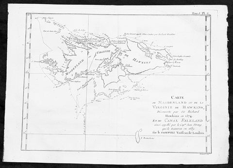
1747 Bellin Antique Map of the Falkland or Maldives Islands Argentina South America
- Title: Carte de Maidenland ou de la Virginie de Hawkins...Richard Hawkins 1574...Cap Jean Strong...1689
- Date: 1747
- Condition : (A+) Fine Condition
- Ref: 35488
- Size: 14in x 10in (360mm x 255mm)
Description:
This fine, original copper-plate engraved antique map of the Falkland Islands by Jacques Nicolas Bellin in 1750 was published in Antoine François Prevosts 15 volumes of Histoire Generale des Voyages written by Prevost & other authors between 1746-1790.
Although Fuegians from Patagonia may have visited the Falkland Islands in prehistoric times, the islands were uninhabited at the time of their discovery by Europeans. Claims of discovery date back to the 16th century, but no consensus exists on whether early explorers discovered the Falklands or other islands in the South Atlantic. The first recorded landing on the islands is attributed to English captain John Strong, who, en route to Peru\'s and Chile\'s littoral in 1690, discovered the Falkland Sound and noted the islands\' water and game.
The Falklands remained uninhabited until the 1764 establishment of Port Louis on East Falkland by French captain Louis Antoine de Bougainville, and the 1766 foundation of Port Egmont on Saunders Island by British captain John MacBride. Whether or not the settlements were aware of each other\'s existence is debated by historians. In 1766, France surrendered its claim on the Falklands to Spain, which renamed the French colony Puerto Soledad the following year. Problems began when Spain discovered and captured Port Egmont in 1770. War was narrowly avoided by its restitution to Britain in 1771.
Both the British and Spanish settlements coexisted in the archipelago until 1774, when Britain\'s new economic and strategic considerations led it to voluntarily withdraw from the islands, leaving a plaque claiming the Falklands for King George III. Spain\'s Viceroyalty of the Río de la Plata became the only governmental presence in the territory. West Falkland was left abandoned, and Puerto Soledad became mostly a prison camp.Amid the British invasions of the Río de la Plata during the Napoleonic Wars in Europe, the islands\' governor evacuated the archipelago in 1806; Spain\'s remaining colonial garrison followed suit in 1811, except for gauchos and fishermen who remained voluntarily.
General Definitions:
Paper thickness and quality: - Heavy and stable
Paper color : - off white
Age of map color: -
Colors used: -
General color appearance: -
Paper size: - 14in x 10in (355mm x 255mm)
Plate size: - 12in x 8in (305mm x 205mm)
Margins: - Min 1/2in (12mm)
Imperfections:
Margins: - None
Plate area: - None
Verso: - None
Background:
One of Antoine Francois Prevosts monumental undertakings was his history of exploration & discovery in 15 volumes titledHistoire Générale des Voyages written between 1746-1759 and was extended to 20 volumes after his death by various authors.
The 20 volumes cover the early explorations & discoveries on 3 continents: Africa (v. 1-5), Asia (v. 5-11), and America (v. 12-15) with material on the finding of the French, English, Dutch, and Portugese.
A number of notable cartographers and engravers contributed to the copper plate maps and views to the 20 volumes including Nicolas Bellin, Jan Schley, Chedel, Franc Aveline, Fessard, and many others.
The African volumes cover primarily coastal countries of West, Southern, and Eastern Africa, plus the Congo, Madagascar, Arabia and the Persian Gulf areas.
The Asian volumes cover China, Korea, Tibet, Japan, Philippines, and countries bordering the Indian Ocean.
Volume 11 includes Australia and Antarctica.
Volumes 12-15 cover voyages and discoveries in America, including the East Indies, South, Central and North America.
Volumes 16-20 include supplement volumes & tables along with continuation of voyages and discoveries in Russia, Northern Europe, America, Asia & Australia.
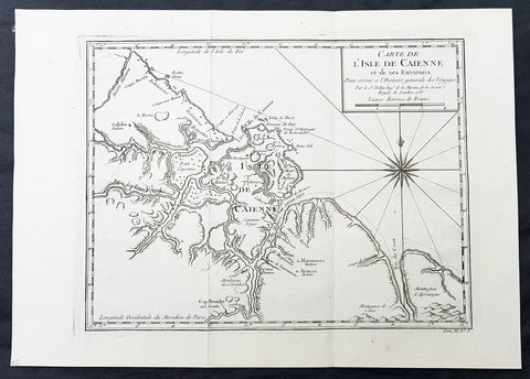
1753 Bellin Antique Map of The Island of Cayenne French Guyana, South America
- Title: Carte de L Isle De Caienne et de ses Environs...1753
- Date: 1753
- Condition : (A+) Fine Condition
- Ref: 92015
- Size: 15in x 11in (390mm x 275mm)
Description:
This fine, original copper-plate engraved antique map of the City Island of Cayenne in French Guyana, South America by Jacques Nicolas Bellin was engraved in 1753 - dated - and was published in Antoine François Prevosts 15 volumes of Histoire Generale des Voyages written by Prevost & other authors between 1746-1790.
Cayenne is the capital city of French Guiana, an overseas region and department of France located in South America. The city stands on a former island at the mouth of the Cayenne River on the Atlantic coast. The city\'s motto is fert aurum industria, which means \"work brings wealth.
Ignored by Spanish explorers, who found the region too hot and poor to be claimed, the region was not colonized until 1604, when a French settlement was founded. However, it was soon destroyed by the Portuguese, who were determined to enforce the provisions of the Treaty of Tordesillas. French colonists returned in 1643 and founded Cayenne, but they were forced to leave once more following Amerindian attacks. In 1664, France finally succeeded at establishing a permanent settlement at Cayenne. Over the next decade the colony changed hands between the French, Dutch, and English, before being restored to France. It was captured by an Anglo-Portuguese force at the invasion of Cayenne in 1809 and administered from Brazil until 1814, when it was returned to French control. It was used as a French penal colony from 1854 to 1938.
General Definitions:
Paper thickness and quality: - Heavy and stable
Paper color : - off white
Age of map color: -
Colors used: -
General color appearance: -
Paper size: - 13in x 10in (330mm x 255mm)
Plate size: - 12in x 9in (305mm x 230mm)
Margins: - Min 1/2in (12mm)
Imperfections:
Margins: - None
Plate area: - None
Verso: - None
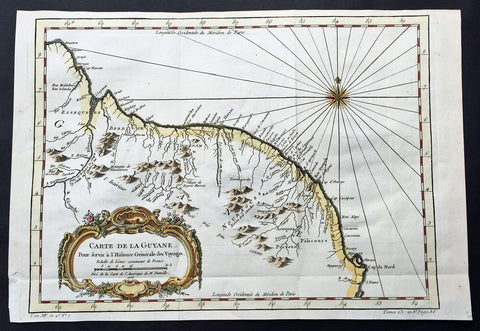
1757 Bellin Large Antique Map of Guyana, South America
- Title: Carte de la Guyana...1757
- Date: 1757
- Condition : (A+) Fine Condition
- Ref: 60940
- Size: 15in x 10in (380mm x 255mm)
Description:
This fine, original copper-plate engraved antique map of Guyana, South America by Jacques Nicolas Bellin was engraved in 1757 - dated - and was published in Antoine François Prevosts 15 volumes of Histoire Generale des Voyages written by Prevost & other authors between 1746-1790.
Guyana officially the Co-operative Republic of Guyana, is a sovereign state on the northern mainland of South America. It is, however, often considered part of the Caribbean region because of its strong cultural, historical, and political ties with other Anglo Caribbean countries and the Caribbean Community (CARICOM). Guyana is bordered by the Atlantic Ocean to the north, Brazil to the south and southwest, Suriname to the east and Venezuela to the west.
There are nine indigenous tribes residing in Guyana: the Wai Wai, Macushi, Patamona, Lokono, Kalina, Wapishana, Pemon, Akawaio and Warao. Historically the Lokono and Kalina tribes dominated Guyana. Although Christopher Columbus sighted Guyana during his third voyage (in 1498), and Sir Walter Raleigh wrote an account of its discovery in 1596, the Dutch were the first to establish colonies: Essequibo (1616), Berbice (1627), and Demerara (1752). After the British assumed control in 1796, the Dutch formally ceded the area in 1814. In 1831 the three separate colonies became a single British colony known as British Guiana.
General Definitions:
Paper thickness and quality: - Heavy and stable
Paper color : - off white
Age of map color: - Early
Colors used: - Green, yellow, orange
General color appearance: - Authentic
Paper size: - 15in x 10in (380mm x 255mm)
Plate size: - 13in x 9 1/2in (330mm x 245mm)
Margins: - Min 1/2in (12mm)
Imperfections:
Margins: - None
Plate area: - Folds as issued
Verso: - None
One of Antoine Francois Prevosts monumental undertakings was his history of exploration & discovery in 15 volumes titledHistoire Générale des Voyages written between 1746-1759 and was extended to 20 volumes after his death by various authors.
The 20 volumes cover the early explorations & discoveries on 3 continents: Africa (v. 1-5), Asia (v. 5-11), and America (v. 12-15) with material on the finding of the French, English, Dutch, and Portugese.
A number of notable cartographers and engravers contributed to the copper plate maps and views to the 20 volumes including Nicolas Bellin, Jan Schley, Chedel, Franc Aveline, Fessard, and many others.
The African volumes cover primarily coastal countries of West, Southern, and Eastern Africa, plus the Congo, Madagascar, Arabia and the Persian Gulf areas.
The Asian volumes cover China, Korea, Tibet, Japan, Philippines, and countries bordering the Indian Ocean.
Volume 11 includes Australia and Antarctica.
Volumes 12-15 cover voyages and discoveries in America, including the East Indies, South, Central and North America.
Volumes 16-20 include supplement volumes & tables along with continuation of voyages and discoveries in Russia, Northern Europe, America, Asia & Australia.
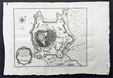
1753 Bellin Antique Map Plan of the City of Cayenne French Guyana, South America
- Title: La Ville De Cayenne...1753
- Date: 1753
- Condition : (A+) Fine Condition
- Ref: 92016
- Size: 15in x 11in (390mm x 275mm)
Description:
This beautifully engraved original antique map a plan of the city of Cayenne capital of French Guyana, South America was engraved by Jacques Nicolas Bellin in 1753 - the date is engraved in the title cartouche - and was published by Jacques Nicolas Bellin for Antoine-François Prevosts 20 volume edition of L`Histoire Generale des Voyages published by Pierre de Hondt, The Hague in 1747. (Ref: Tooley; M&B)
General Description:
Paper thickness and quality: - Heavy and stable
Paper color: - white
Age of map color: -
Colors used: -
General color appearance: -
Paper size: - 15in x 11in (390mm x 275mm)
Plate size: - 11 1/2in x 9 1/2in (290mm x 245mm)
Margins: - min. 1in (25mm)
Imperfections:
Margins: - None
Plate area: - Folds as issued
Verso: - None
Condition : (A+) Fine Condition

1760 Bellin Antique Map The Entrance to the Sierra Leone River, Africa
- Title: Carte De L Entrée De La Riviere De Sierra Leona...
- Date: 1760
- Condition : (A+) Fine Condition
- Ref: 25836
- Size: 10in x 7 1/2in (255mm x 190mm)
Description:
This beautifully hand coloured original antique map of the Sierra Leone River estuary by J N Bellin in 1760 was published in Antoine-François Prevosts 20 volume edition of L`Histoire Generale des Voyages published by Pierre de Hondt, The Hague between 1747 & 1785.
The Sierra Leone River is a river estuary on the Atlantic Ocean in Western Sierra Leone. It is formed by the Port Loko Creek and Rokel River and is between 4 and 10 miles wide (6–16 km) and 25 miles (40 km) long. It is the largest natural harbour in the African continent. Several islands, including Tasso Island (the largest), Tombo Island, and the historically important Bunce Island, are located in the estuary. (Ref: Tooley; M&B)
General Description: Paper thickness and quality: - Heavy and stable
Paper color: - white
Age of map color: - Early
Colors used: - Green, yellow, red
General color appearance: - Authentic
Paper size: - 10in x 7 1/2in (255mm x 190mm)
Plate size: - 9in x 7in (230mm x 180mm)
Margins: - min. 1/4in (10mm)
Imperfections: Margins: - None
Plate area: - None
Verso: - None
Condition : (A+) Fine Condition
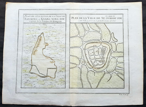
1755 Prevost & Schley Antique Map, View of Nanking or Nanjing in Jiangsu, China
- Title: Plan De L Enceinte de la Ville De Nan-King ou Kyang-Ning-Fou Capitale de la Province de Kyang-nan; Plan de la Ville De Su-Tcheou-Fou
- Date: 1755
- Condition : (A+) Fine Condition
- Ref: 15844
- Size: 13 1/2in x 10in (345mm x 255mm)
Description:
This fine, original copper-plate engraved antique map a birds-eye view of the walled cities of Nanjing & Zhenzhou, in the Jiangsu Province of China by Jakob van Schley in 1755 was published in Antoine François Prevosts 15 volumes of Histoire Generale des Voyageswritten by Prevost & other authors between 1746-1790.
Nanjing formerly romanized as Nanking and Nankin, is the capital of Jiangsu province of the People\'s Republic of China and the second largest city in the East China region, with an administrative area of 6,600 km2 (2,500 sq mi) and a total population of 8,270,500.
Situated in the Yangtze River Delta region, Nanjing has a prominent place in Chinese history and culture, having served as the capital of various Chinese dynasties, kingdoms and republican governments dating from the 3rd century to 1949, and has thus long been a major center of culture, education, research, politics, economy, transport networks and tourism, being the home to one of the world\'s largest inland ports.
Nanjing, one of the nation\'s most important cities for over a thousand years, is recognized as one of the Four Great Ancient Capitals of China. It has been one of the world\'s largest cities, enjoying peace and prosperity despite wars and disasters. Nanjing served as the capital of Eastern Wu, one of the three major states in the Three Kingdoms period (211–280); the Eastern Jin and each of the Southern Dynasties (Liu Song, Southern Qi, Liang and Chen), which successively ruled southern China from 317–589; the Southern Tang, one of the Ten Kingdoms (937–76); the Ming dynasty when, for the first time, all of China was ruled from the city (1368–1421);[15] and the Republic of China (1927–37, 1945–49) prior to its flight to Taiwan during the Chinese Civil War. The city also served as the seat of the rebel Taiping Heavenly Kingdom (1851–64) and the Japanese puppet regime of Wang Jingwei (1940–45) during the Second Sino-Japanese War. It suffered appalling atrocities in both conflicts, including the Nanjing Massacre.
General Definitions:
Paper thickness and quality: - Heavy and stable
Paper color : - off white
Age of map color: - Early
Colors used: - Yellow, green, orange
General color appearance: - Authentic
Paper size: - 13 1/2in x 10in (345mm x 255mm)
Plate size: - 11 1/2in x 9in (295mm x 230mm)
Margins: - Min 1/2in (12mm)
Imperfections:
Margins: - None
Plate area: - None
Verso: - None
Background:
One of Antoine Francois Prevosts monumental undertakings was his history of exploration & discovery in 15 volumes titledHistoire Générale des Voyages written between 1746-1759 and was extended to 20 volumes after his death by various authors.
The 20 volumes cover the early explorations & discoveries on 3 continents: Africa (v. 1-5), Asia (v. 5-11), and America (v. 12-15) with material on the finding of the French, English, Dutch, and Portugese.
A number of notable cartographers and engravers contributed to the copper plate maps and views to the 20 volumes including Nicolas Bellin, Jan Schley, Chedel, Franc Aveline, Fessard, and many others.
The African volumes cover primarily coastal countries of West, Southern, and Eastern Africa, plus the Congo, Madagascar, Arabia and the Persian Gulf areas.
The Asian volumes cover China, Korea, Tibet, Japan, Philippines, and countries bordering the Indian Ocean.
Volume 11 includes Australia and Antarctica.
Volumes 12-15 cover voyages and discoveries in America, including the East Indies, South, Central and North America.
Volumes 16-20 include supplement volumes & tables along with continuation of voyages and discoveries in Russia, Northern Europe, America, Asia & Australia.
Jakob van der Schley aka Jakob van Schley (1715 - 1779) was a Dutch draughtsman and engraver. He studied under Bernard Picart (1673-1733) whose style he subsequently copied. His main interests were engraving portraits and producing illustrations for \\\"La Vie de Marianne\\\" by Pierre Carlet de Chamblain de Marivaux (1688-1763) published in The Hague between 1735 and 1747.
He also engraved the frontispieces for a 15-volume edition of the complete works of Pierre de Brantôme (1540-1614), Oeuvres du seigneur de Brantôme, published in The Hague in 1740.
He is also responsible for most of the plates in the Hague edition of Prévosts Histoire générale des voyages. (Ref: Tooley; M&B)
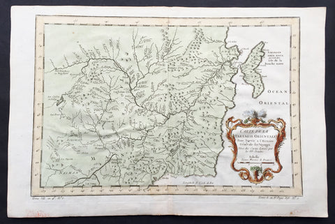
1760 Bellin Antique Map of Manchurian Empire, Mongolia, China, Sakhalin Islands
- Title: Carte De la Tartarie Orientale...P.P Jesuits
- Date: 17560
- Condition : (A+) Fine Condition
- Ref: 60927
- Size: 15in x 10in (380mm x 255mm)
Description:
This fine, original copper-plate engraved antique map of old Manchurian Empire - now NE China, Mongolia & Russia stretching from Beijing to the Sakhalin Islands by Jacques Nicolas Bellin in 1760 was published in Antoine François Prevosts 15 volumes of Histoire Generale des Voyages written by Prevost & other authors between 1746-1790.
General Definitions:
Paper thickness and quality: - Heavy and stable
Paper color : - off white
Age of map color: - Early
Colors used: - Green, yellow, red
General color appearance: - Authentic
Paper size: - 15in x 10in (380mm x 255mm)
Plate size: - 13in x 9in (330mm x 230mm)
Margins: - Min 1/2in (6mm)
Imperfections:
Margins: - None
Plate area: - Folds as issued
Verso: - None
Background:
One of Antoine Francois Prevosts monumental undertakings was his history of exploration & discovery in 15 volumes titledHistoire Générale des Voyages written between 1746-1759 and was extended to 20 volumes after his death by various authors.
The 20 volumes cover the early explorations & discoveries on 3 continents: Africa (v. 1-5), Asia (v. 5-11), and America (v. 12-15) with material on the finding of the French, English, Dutch, and Portugese.
A number of notable cartographers and engravers contributed to the copper plate maps and views to the 20 volumes including Nicolas Bellin, Jan Schley, Chedel, Franc Aveline, Fessard, and many others.
The African volumes cover primarily coastal countries of West, Southern, and Eastern Africa, plus the Congo, Madagascar, Arabia and the Persian Gulf areas.
The Asian volumes cover China, Korea, Tibet, Japan, Philippines, and countries bordering the Indian Ocean.
Volume 11 includes Australia and Antarctica.
Volumes 12-15 cover voyages and discoveries in America, including the East Indies, South, Central and North America.
Volumes 16-20 include supplement volumes & tables along with continuation of voyages and discoveries in Russia, Northern Europe, America, Asia & Australia.
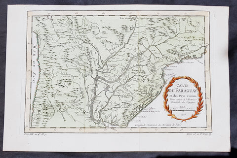
1756 Bellin Antique Map of Paraguay & Brazil, South America
- Title: Carte Du Paraguay...1756
-
Date: 1756
Condition : (A+) Fine Condition - Ref: 60939
- Size: 15in x 10in (380mm x 255mm)
Description:
This fine, original copper-plate engraved antique map of Paraguay South America, by Jacques Nicolas Bellin in 1756 was published in Antoine François Prevosts 15 volumes of Histoire Generale des Voyages written by Prevost & other authors between 1746-1790.
The first Europeansto explore the country were Spanish explorers in 1516. The Spanish explorer Juan de Salazar de Espinosa founded the settlement of Asunción on 15 August 1537. The city eventually became the center of a Spanish colonial province of Paraguay.
An attempt to create an autonomous Christian Indian nation was undertaken by Jesuit missions and settlements in this part of South America in the eighteenth century, which included portions of Uruguay, Argentina, and Brazil. They developed Jesuit reductions to bring Guarani populations together at Spanish missions and protect them from virtual slavery by Spanish settlers and Portuguese slave raiders, the Bandeirantes. In addition to seeking their conversion to Christianity. Catholicism in Paraguay was influenced by the indigenous peoples; the syncretic religion has absorbed native elements. The reducciones flourished in eastern Paraguay for about 150 years, until the expulsion of the Jesuits by the Spanish Crown in 1767. The ruins of two 18th-century Jesuit Missions of La Santísima Trinidad de Paraná and Jesús de Tavarangue have been designated as World Heritage Sites by UNESCO.
In western Paraguay Spanish settlement and Christianity were strongly resisted by the nomadic Guaycuru and other nomads from the 16th century onward. Most of these peoples were absorbed into the mestizo population in the 18th and 19th centuries.
General Definitions:
Paper thickness and quality: - Heavy and stable
Paper color : - off white
Age of map color: - Early
Colors used: - Yellow, green, red
General color appearance: - Authentic
Paper size: - 15in x 10in (380mm x 255mm)
Plate size: - 13in x 8 1/2in (330mm x 215mm)
Margins: - Min 1/2in (12mm)
Imperfections:
Margins: - None
Plate area: - Folds as issued
Verso: - None
Background:
One of Antoine Francois Prevosts monumental undertakings was his history of exploration & discovery in 15 volumes titledHistoire Générale des Voyages written between 1746-1759 and was extended to 20 volumes after his death by various authors.
The 20 volumes cover the early explorations & discoveries on 3 continents: Africa (v. 1-5), Asia (v. 5-11), and America (v. 12-15) with material on the finding of the French, English, Dutch, and Portugese.
A number of notable cartographers and engravers contributed to the copper plate maps and views to the 20 volumes including Nicolas Bellin, Jan Schley, Chedel, Franc Aveline, Fessard, and many others.
The African volumes cover primarily coastal countries of West, Southern, and Eastern Africa, plus the Congo, Madagascar, Arabia and the Persian Gulf areas.
The Asian volumes cover China, Korea, Tibet, Japan, Philippines, and countries bordering the Indian Ocean.
Volume 11 includes Australia and Antarctica.
Volumes 12-15 cover voyages and discoveries in America, including the East Indies, South, Central and North America.
Volumes 16-20 include supplement volumes & tables along with continuation of voyages and discoveries in Russia, Northern Europe, America, Asia & Australia.
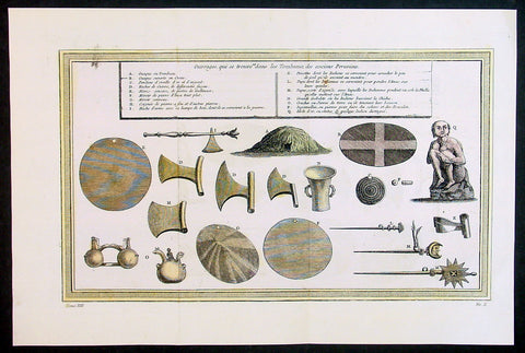
1755 Prevost & Schley Antique Print of Artifacts Recovered from Inca Burial Tomb
- Title: Puvrages qui se trouvent dans les Tombeaux des anciens Peruviens
- Date: 1755
- Condition : (A+) Fine Condition
- Ref: 34132
- Size: 15in x 10in (385mm x 255mm)
Description:
This fine, original copper-plate engraved antique print of artifacts found in an Inca Tomb in Peru by Jakob van Schley in 1755 - after De Bry - was published in Antoine François Prevosts 15 volumes of Histoire Generale des Voyages written by Prevost & other authors between 1746-1790.
The Inca Empire also known as the Incan Empire and the Inka Empire, was the largest empire in pre-Columbian America, and possibly the largest empire in the world in the early 16th century. Its political and administrative structure \"was the most sophisticated found among native peoples\" in the Americas.The administrative, political and military center of the empire was located in Cusco in modern-day Peru. The Inca civilization arose from the highlands of Peru sometime in the early 13th century. Its last stronghold was conquered by the Spanish in 1572.
From 1438 to 1533, the Incas incorporated a large portion of western South America, centered on the Andean Mountains, using conquest and peaceful assimilation, among other methods. At its largest, the empire joined Peru, large parts of modern Ecuador, western and south central Bolivia, northwest Argentina, north and central Chile and a small part of southwest Colombia into a state comparable to the historical empires of Eurasia. Its official language was Quechua.Many local forms of worship persisted in the empire, most of them concerning local sacred Huacas, but the Inca leadership encouraged the worship of Inti – their sun god – and imposed its sovereignty above other cults such as that of Pachamama. The Incas considered their king, the Sapa Inca, to be the \"son of the sun.\"
The Inca Empire was unique in that it lacked many features associated with civilization in the Old World. In the words of one scholar, \"The Incas lacked the use of wheeled vehicles. They lacked animals to ride and draft animals that could pull wagons and plows... [They] lacked the knowledge of iron and steel... Above all, they lacked a system of writing... Despite these supposed handicaps, the Incas were still able to construct one of the greatest imperial states in human history\". Notable features of the Inca Empire include its monumental architecture, especially stonework, extensive road network reaching all corners of the empire, finely-woven textiles, use of knotted strings (quipu) for record keeping and communication, agricultural innovations in a difficult environment, and the organization and management fostered or imposed on its people and their labor.
The Incan economy has been described in contradictory ways by scholars: as \"feudal, slave, socialist (here one may choose between socialist paradise or socialist tyranny)\". The Inca empire functioned largely without money and without markets. Instead, exchange of goods and services was based on reciprocity between individuals and among individuals, groups, and Inca rulers. \"Taxes\" consisted of a labor obligation of a person to the Empire. The Inca rulers (who theoretically owned all the means of production) reciprocated by granting access to land and goods and providing food and drink in celebratory feasts for their subjects.
General Definitions:
Paper thickness and quality: - Heavy and stable
Paper color : - off white
Age of map color: - Early
Colors used: - Yellow, green, red
General color appearance: - Authentic
Paper size: - 15in x 10in (385mm x 255mm)
Plate size: - 14in x 8 1/2in (355mm x 220mm)
Margins: - Min 1in (25mm)
Imperfections:
Margins: - None
Plate area: - Folds as issued
Verso: - None
Background:
One of Antoine Francois Prevosts monumental undertakings was his history of exploration & discovery in 15 volumes titledHistoire Générale des Voyages written between 1746-1759 and was extended to 20 volumes after his death by various authors.
The 20 volumes cover the early explorations & discoveries on 3 continents: Africa (v. 1-5), Asia (v. 5-11), and America (v. 12-15) with material on the finding of the French, English, Dutch, and Portugese.
A number of notable cartographers and engravers contributed to the copper plate maps and views to the 20 volumes including Nicolas Bellin, Jan Schley, Chedel, Franc Aveline, Fessard, and many others.
The African volumes cover primarily coastal countries of West, Southern, and Eastern Africa, plus the Congo, Madagascar, Arabia and the Persian Gulf areas.
The Asian volumes cover China, Korea, Tibet, Japan, Philippines, and countries bordering the Indian Ocean.
Volume 11 includes Australia and Antarctica.
Volumes 12-15 cover voyages and discoveries in America, including the East Indies, South, Central and North America.
Volumes 16-20 include supplement volumes & tables along with continuation of voyages and discoveries in Russia, Northern Europe, America, Asia & Australia.
Jakob van der Schley aka Jakob van Schley (1715 - 1779) was a Dutch draughtsman and engraver. He studied under Bernard Picart (1673-1733) whose style he subsequently copied. His main interests were engraving portraits and producing illustrations for \\\"La Vie de Marianne\\\" by Pierre Carlet de Chamblain de Marivaux (1688-1763) published in The Hague between 1735 and 1747.
He also engraved the frontispieces for a 15-volume edition of the complete works of Pierre de Brantôme (1540-1614), \\\"Oeuvres du seigneur de Brantôme\\\", published in The Hague in 1740.
He is also responsible for most of the plates in the Hague edition of Prévosts Histoire générale des voyages. (Ref: Tooley; M&B)
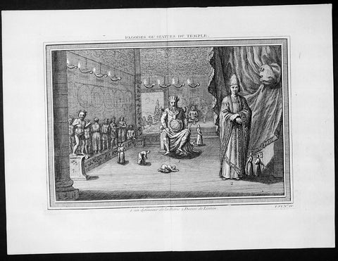
1755 Prevost & Schley Antique Print Dharmapala the Defender Buddhist Gods Pagoda
- Title: Pagodes ou Statues Du Temple
- Date: 1755
- Condition : (A+) Fine Condition
- Ref: 25935
- Size: 15in x 10in (385mm x 255mm)
Description:
This fine, original copper-plate engraved antique print of Dharmapala the defender Buddhist God & Goddess in a Pagoda Temple by Jakob van Schley in 1755 was published in Antoine François Prevosts 15 volumes of Histoire Generale des Voyages written by Prevost & other authors between 1746-1790.
A protector of Buddhist dharma is called a Dharmapala in Buddhism. They are typically divinities, usually depicted with wrathful iconography in the Mahayana and tantric traditions of Buddhism. The wrath depicts their believed willingness to defend and guard Buddhist followers from dangers and enemies. The Astasena, or eight nonhuman super beings, for example are one of the list of dharmapalas. The Astasena dharmapala include, state Buswell and Lopez, Garuda, Deva, Naga, Yaksa, Gandharva, Asura, Kimnara and Mahoraga.
In Vajrayana iconography and thangka depictions, dharmapālas are fearsome beings, often with many heads, many hands, or many feet. Dharmapālas often have blue, black or red skin, and a fierce expression with protruding fangs. Though dharmapālas have a terrifying appearance and countenance, they are all bodhisattvas or buddhas, meaning that they are embodiments of compassion that act in a wrathful way for the benefit of sentient beings.
The devotional worship of dharmapalas in the Tibetan tradition is traceable to early 8th-century
General Definitions:
Paper thickness and quality: - Heavy and stable
Paper color : - off white
Age of map color: -
Colors used: -
General color appearance: -
Paper size: - 15in x 10in (385mm x 255mm)
Plate size: - 14in x 8 1/2in (355mm x 220mm)
Margins: - Min 1in (25mm)
Imperfections:
Margins: - None
Plate area: - None
Verso: - None
Background:
One of Antoine Francois Prevosts monumental undertakings was his history of exploration & discovery in 15 volumes titledHistoire Générale des Voyages written between 1746-1759 and was extended to 20 volumes after his death by various authors.
The 20 volumes cover the early explorations & discoveries on 3 continents: Africa (v. 1-5), Asia (v. 5-11), and America (v. 12-15) with material on the finding of the French, English, Dutch, and Portugese.
A number of notable cartographers and engravers contributed to the copper plate maps and views to the 20 volumes including Nicolas Bellin, Jan Schley, Chedel, Franc Aveline, Fessard, and many others.
The African volumes cover primarily coastal countries of West, Southern, and Eastern Africa, plus the Congo, Madagascar, Arabia and the Persian Gulf areas.
The Asian volumes cover China, Korea, Tibet, Japan, Philippines, and countries bordering the Indian Ocean.
Volume 11 includes Australia and Antarctica.
Volumes 12-15 cover voyages and discoveries in America, including the East Indies, South, Central and North America.
Volumes 16-20 include supplement volumes & tables along with continuation of voyages and discoveries in Russia, Northern Europe, America, Asia & Australia.
Jakob van der Schley aka Jakob van Schley (1715 - 1779) was a Dutch draughtsman and engraver. He studied under Bernard Picart (1673-1733) whose style he subsequently copied. His main interests were engraving portraits and producing illustrations for \\\"La Vie de Marianne\\\" by Pierre Carlet de Chamblain de Marivaux (1688-1763) published in The Hague between 1735 and 1747.
He also engraved the frontispieces for a 15-volume edition of the complete works of Pierre de Brantôme (1540-1614), \\\"Oeuvres du seigneur de Brantôme\\\", published in The Hague in 1740.
He is also responsible for most of the plates in the Hague edition of Prévosts Histoire générale des voyages. (Ref: Tooley; M&B)
1755 Prevost & Schley Antique City Map of Hangzhou in Zhejiang Province, China
- Title: Plan De la Ville de Hang-Tcheou-Fou ou Hang chew Fu Capitale de la Province de Che-Kiang
- Date: 1755
- Condition : (A+) Fine Condition
- Ref: 25812
- Size: 15in x 10in (385mm x 255mm)
Description:
This fine, original copper-plate engraved antique map a plan of the city of Hangzhou (here Hang Chew Fu) in the Zhejiang province of China by Jakob van Schley in 1755 - after Jean-Baptiste Du Halde - was published in Antoine François Prevosts 15 volumes of Histoire Generale des Voyages written by Prevost & other authors between 1746-1789.
Jean-Baptiste Du Halde, born in Paris on 1 February 1674 and died 18 August 1743, was a French Jesuit historian specializing in China. He did not travel to China, but collected seventeen Jesuit missionaries\\\' reports and provided an encyclopedic survey of the history, culture and society of China and Chinese Tartary, that is, Manchuria.
General Definitions:
Paper thickness and quality: - Heavy and stable
Paper color : - off white
Age of map color: - Original
Colors used: - Yellow, green, blue, pink
General color appearance: - Authentic
Paper size: - 10in x 7 1/2in (255mm x 190mm)
Plate size: - 10in x 7 1/2in (255mm x 190mm)
Margins: - Min 1/2in (12mm)
Imperfections:
Margins: - None
Plate area: - None
Verso: - None
Background:
Hangzhou romanization Hang-chou, conventional Hangchow, city and capital of Zhejiang sheng (province), China. The city is located in the northern part of the province on the north bank of the Qiantang River estuary at the head of Hangzhou Bay. It has water communications with the interior of Zhejiang to the south, is the southern terminus of the Grand Canal, and is linked to the network of canals and waterways that cover the Yangtze River (Chang Jiang) delta area to the north. The city stands at the eastern foot of a scenic range of hills, the Tianmu (“Eye of Heaven”) Mountains, and on the shore of the famous Xi (West) Lake, celebrated in poetry and paintings for its beauty and a favourite imperial retreat.
The county of Qiantang was first established at this site under the Qin dynasty (221–207 BCE) but did not start developing until the 4th and 5th centuries CE, when the Yangtze River delta area began to be settled. A prefecture named Hangzhou was created there in 589, during the Sui dynasty (581–618), which is the source of the city’s name. It became a major local centre with the completion of the Jiangnan Canal (then the southern section of the Grand Canal) in 609. During the Ten Kingdoms (Shiguo) period (907–960), Hangzhou was the capital of the state of Wu-Yue. In the later Song period (960–1279), northern China fell to the Jin (Juchen) dynasty (1115–1234); from 1127 the Song rulers were confined to southern China, and they made Hangzhou (then known as Lin’an) their capital. A centre of commerce, it was visited in the late 13th century by the Venetian traveler Marco Polo, who called it Kinsai, or Quinsay; it then had an estimated population of 1 million to 1.5 million.
Although it never again reached the peak of importance that it had achieved as capital of the Nan (Southern) Song, Hangzhou remained important. Under the Ming (1368–1644) and Qing (1644–1911/12) dynasties, it was a superior prefecture, in addition to being the provincial capital of Zhejiang. It became immensely wealthy, being at the centre of a fertile rice-growing area as well as being the site of the most important silk industries in China. It also was famous as a centre of culture, producing numerous writers, painters, and poets. Its importance as a port dwindled, however, as Hangzhou Bay gradually silted up and as its outport, Ganpu, became useless. From the 14th century its trade gradually shifted to Ningbo to the southeast on the southern shore of the bay and, in the 19th century, to the new city of Shanghai, some 100 miles (160 km) to the northeast at the mouth of the Yangtze. In 1861, during the Taiping Rebellion (1850–64), the city fell to the rebels and suffered severe damage.
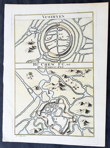
1755 Prevost Antique Plans Cities of Jinhua & Pinghu in Zhejiang Province, China
- Title: Vusihyen; Hou-Tcheou-Fou
- Date: 1747
- Condition : (A+) Fine Condition
- Ref: 01-9784
- Size: 10in x 8in (255mm x 205mm)
Description:
This fine, original copper-plate engraved antique map, plans of the cities of Jinhua & Pinghu in the eastern Chinese province of Zhejiang by Jakob van Schley in 1755 - after Jean-Baptiste Du Halde - was published in Antoine François Prevosts 15 volumes of Histoire Generale des Voyages written by Prevost & other authors between 1746-1789.
Jean-Baptiste Du Halde, born in Paris on 1 February 1674 and died 18 August 1743, was a French Jesuit historian specializing in China. He did not travel to China, but collected seventeen Jesuit missionaries\\\' reports and provided an encyclopedic survey of the history, culture and society of China and Chinese Tartary, that is, Manchuria.
General Definitions:
Paper thickness and quality: - Heavy and stable
Paper color : - off white
Age of map color: - Original
Colors used: - Yellow, green, blue, pink
General color appearance: - Authentic
Paper size: - 10in x 7 1/2in (255mm x 190mm)
Plate size: - 10in x 7 1/2in (255mm x 190mm)
Margins: - Min 1/2in (12mm)
Imperfections:
Margins: - None
Plate area: - None
Verso: - None
Background:
Zhejiang formerly romanized as Chekiang, is an eastern coastal province of China. Zhejiang is bordered by the Jiangsu province and the Shanghai municipality to the north, the Anhui province to the northwest, the Jiangxi province to the west, and the Fujian province to the south. To the east is the East China Sea, beyond which lies the Ryukyu Islands of Japan.
Zhejiang was finally conquered by the Mongols in the late 13th century who later established the short lived Yuan Dynasty.
The Ming dynasty, which drove out the Mongols in 1368, finally established the present day province of Zhejiang with its borders having little changes since this establishment.
As in other coastal provinces, number of fortresses were constructed along the Zhejiang coast during the early Ming to defend the land against pirate incursions. Some of them have been preserved or restored, such as Pucheng in the south of the province (Cangnan County).
Under the late Ming dynasty and the Qing dynasty that followed it, Zhejiang\'s ports were important centers of international trade.
In 1727 the to-min or \'idle people\' of Cheh Kiang province (a Ningpo name still existing), the yoh-hu or \'music people\' of Shanxi province, the si-min or \'small people\' of Kiang Su (Jiangsu) province, and the Tanka people or \'egg-people\' of Canton (to this day the boat population there), were all freed from their social disabilities, and allowed to count as free men. Cheh Kiang is another romanization for Zhejiang. The Duomin are a caste of outcasts in this province.
During the First Opium War, the British navy defeated Eight Banners forces at Ningboand Dinghai. Under the terms of the Treaty of Nanking, signed in 1843, Ningbo became one of the five Chinese treaty ports opened to virtually unrestricted foreign trade. Much of Zhejiang came under the control of the Taiping Heavenly Kingdom during the Taiping Rebellion, which resulted in a considerable loss of life in the north-western and central parts of the province, sparing the rest of Zhejiang from the disastrous depopulation that occurred. In 1876, Wenzhou became Zhejiang\'s second treaty port. Jianghuai Mandarin speakers later came to settle in these depopulated regions of northern Zhejiang.
Jinhua is a prefecture-level city in central Zhejiang province in eastern China. It borders the provincial capital of Hangzhou to the northwest, Quzhou to the southwest, Lishui to the south, Taizhou to the east, and Shaoxing to the northeast.
The history of Jinhua dates back to the 2nd century BC, when it was a county subordinate to Shaoxing. It was given the name Jinhua under the Sui dynasty in AD 598 and later became the seat of a prefecture. The present city and its walls date to the time of the Mongol emperors in 1352.
The most famous native of Jinhua is Huang Chuping, a Daoist holy man of the 4th century and reputed immortal whose descendants still live in the area. Wuyang Shan (Reclining Sheep Mountain) is said to be a sheep which was turned to stone by Huang, a trick which he learned through his years of diligently studying Daoism.
Economically Jinhua has always prospered from its position as the regional collecting and processing center for agricultural and forestry products (chiefly rice and bamboo). It is currently the second most important grain producing area in Zhejiang. In 1985 Jinhua was promoted to City status, and now is responsible for administering four cities, four counties and a district. Animals raised there include dairy cattle, meat hogs (for the production of Jinhua ham, a famous local product for 900 years) and honeybees. Jinhua\'s industrial sector has developed more recently, producing machinery, metallurgy, pharmaceuticals, building supplies and electrical and electronic equipment.
The Tang dynasty painter Guan Xiu (Kuan-hsiu) was born in Jinhua. He is known for his paintings of Buddhist holy men.
There are numerous scenic and historical sites in the Jinhua region, including many places associated with the Immortal Huang, and a palace of the Dukes of the Taiping Heavenly Kingdom.
Pinghu is a county-level city in northeast Zhejiang Province, just outside Shanghai. It sits next to the East China Sea and the north shore of Hangzhou Bay. Prior to the Ming Dynasty, Pinghu was part of Haiyan County. In 1430 Pinghu County was established. In 1991 Pinghu became a county-level city under the administration of the prefecture-level city of Jiaxing.
Zhapu, the site of a deepwater harbor, was the principal site of China\'s foreign trade with Korea and Japan during the 18th and 19th century.
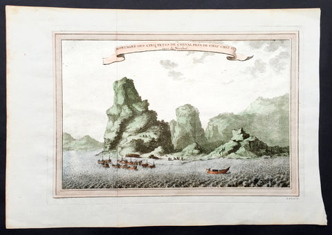
1750 Prevost & Nieuhoff Antique Print View of the Zoushan Archip. Zhejiang China
- Title: Montagne Des Cinq Tetes De Cheval Pres De Chau Cheu Fu
- Date: 1747
- Condition : (A+) Fine Condition
- Ref: 15850
- Size: 14in x 10in (355mm x 255mm)
Description:
This fine original copper-plate engraved antique print a view of the Islands of Zoushan in the in north-eastern Zhejiang Province of eastern China was engraved by Jakob van Schley - after Johannes Nieuhoff - and was published in Antoine François Prevosts 15 volumes of Histoire Generale des Voyageswritten by Prevost & other authors between 1746-1790.
Johannes Nieuhoff (1618-72) was a Dutch diplomat and adventurer, who was perhaps the most widely traveled individual of the seventeenth-century. His experiences included important expeditions to various locations in Brazil, Africa, India, Indonesia, and China. From 1655-57, Nieuhoff made an epic 2,400 trek through China, from Canton to Beijing.
During his Chinese expedition he made numerous drawings of the sites he encountered, including the port town of Chau Cheu Fu in the southern province of Guandong, which was the basis for the present print. Nieuhoff’s important written account, along with engravings of his drawings was first published as Legatio batavica ad magnum Tartariæ chamum Sungteium, modernum Sinæ imperatorem (Amsterdam, 1668). His illustrations proved to be highly influential, as they did much to spawn the genre of chinoiserie in European art and design.
General Definitions:
Paper thickness and quality: - Heavy and stable
Paper color : - off white
Age of map color: - Ewarly
Colors used: - Green, yellow, pink
General color appearance: - Authentic
Paper size: - 14in x 10in (365mm x 250mm)
Plate size: - 12in x 8in (305mm x 205mm)
Margins: - Min 1/2in (12mm)
Imperfections:
Margins: - None
Plate area: - Folds as issued
Verso: - None
Background:
One of Antoine Francois Prevosts monumental undertakings was his history of exploration & discovery in 15 volumes titledHistoire Générale des Voyages written between 1746-1759 and was extended to 20 volumes after his death by various authors.
The 20 volumes cover the early explorations & discoveries on 3 continents: Africa (v. 1-5), Asia (v. 5-11), and America (v. 12-15) with material on the finding of the French, English, Dutch, and Portugese.
A number of notable cartographers and engravers contributed to the copper plate maps and views to the 20 volumes including Nicolas Bellin, Jan Schley, Chedel, Franc Aveline, Fessard, and many others.
The African volumes cover primarily coastal countries of West, Southern, and Eastern Africa, plus the Congo, Madagascar, Arabia and the Persian Gulf areas.
The Asian volumes cover China, Korea, Tibet, Japan, Philippines, and countries bordering the Indian Ocean.
Volume 11 includes Australia and Antarctica.
Volumes 12-15 cover voyages and discoveries in America, including the East Indies, South, Central and North America.
Volumes 16-20 include supplement volumes & tables along with continuation of voyages and discoveries in Russia, Northern Europe, America, Asia & Australia.
Jakob van der Schley aka Jakob van Schley (1715 - 1779) was a Dutch draughtsman and engraver. He studied under Bernard Picart (1673-1733) whose style he subsequently copied. His main interests were engraving portraits and producing illustrations for \"La Vie de Marianne\" by Pierre Carlet de Chamblain de Marivaux (1688-1763) published in The Hague between 1735 and 1747.
He also engraved the frontispieces for a 15-volume edition of the complete works of Pierre de Brantôme (1540-1614), \"Oeuvres du seigneur de Brantôme\", published in The Hague in 1740.
He is also responsible for most of the plates in the Hague edition of Prévost\'s Histoire générale des voyages. (Ref: Tooley; M&B)
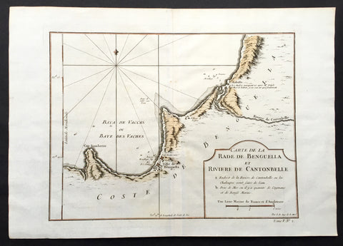
1750 Bellin Antique Map of the Benguela province of Angola, Africa
- Title: Carte de la Rade de Benguella et Riviere de Cantonbelle
- Date: 1750
- Condition : (A+) Fine Condition
- Ref: 25550
- Size: 11 1/2in x 11in (295mm x 280mm)
Description:
This fine large, original copper-plate engraved antique map of the Benguela province of Angola by Jacques Nicolas Bellin in 1750 was published in Antoine François Prevosts 15 volumes of Histoire Generale des Voyageswritten by Prevost & other authors between 1746-1790.
The Portuguese crown created the Kingdom of Benguela in 1615 to improve the conditions to develop the desired land route to Mozambique across Africa. The trading post founded here did not meet the expectations of the Portuguese in mineral resources and soil quality, so a village was only established for the slave trade, under the name of Mbaka
General Definitions:
Paper thickness and quality: - Heavy and stable
Paper color : - off white
Age of map color: - Early
Colors used: - Green, Yellow,
General color appearance: - Authentic
Paper size: - 14in x 10in (355mm x 255mm)
Plate size: - 12in x 9in (305mm x 230mm)
Margins: - Min 1/2in (6mm)
Imperfections:
Margins: - None
Plate area: - Folds as issued
Verso: - None
Background:
One of Antoine Francois Prevosts monumental undertakings was his history of exploration & discovery in 15 volumes titledHistoire Générale des Voyages written between 1746-1759 and was extended to 20 volumes after his death by various authors.
The 20 volumes cover the early explorations & discoveries on 3 continents: Africa (v. 1-5), Asia (v. 5-11), and America (v. 12-15) with material on the finding of the French, English, Dutch, and Portugese.
A number of notable cartographers and engravers contributed to the copper plate maps and views to the 20 volumes including Nicolas Bellin, Jan Schley, Chedel, Franc Aveline, Fessard, and many others.
The African volumes cover primarily coastal countries of West, Southern, and Eastern Africa, plus the Congo, Madagascar, Arabia and the Persian Gulf areas.
The Asian volumes cover China, Korea, Tibet, Japan, Philippines, and countries bordering the Indian Ocean.
Volume 11 includes Australia and Antarctica.
Volumes 12-15 cover voyages and discoveries in America, including the East Indies, South, Central and North America.
Volumes 16-20 include supplement volumes & tables along with continuation of voyages and discoveries in Russia, Northern Europe, America, Asia & Australia.
1747 Bellin Antique Map Plan Cape Coast Castle in Ghana West Africa - Slavery
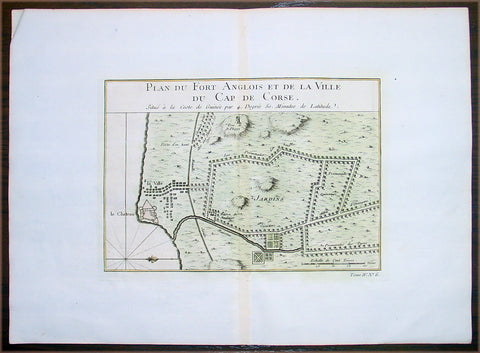
- Title: Plan Du Fort Anglois et de la Ville du Cap De Corse
- Date: 1747
- Condition : (A+) Fine Condition
- Ref: 25657
- Size: 11 1/2in x 11in (295mm x 280mm)
Description:
This beautifully hand coloured original antique map a plan of the Cape Coast Castle - the notorious Slave Castle - situated in the West African country of Ghana was published in 1747 by Jacques Nicolas Bellin for Antoine-François Prevosts 20 volume edition of L`Histoire Generale des Voyages published by Pierre de Hondt, The Hague between 1747 & 1785.
Background: Cape Coast Castle is one of a number of "slave castles", fortifications in Ghana built by Swedish traders, originally for trade in timber and gold, later used in the trans-Atlantic slave trade. Other Ghanaian slave castles include the Portuguese foundation of Elmina Castle (later Dutch) and Fort Christiansborg. They were used to hold slaves before they were loaded onto ships and traded in the Americas and the Caribbean. This “gate of no return” was the last stop before crossing the great Atlantic Ocean (Ref: Tooley; M&B)
General Description:
Paper thickness and quality: - Heavy and stable
Paper color: - off white
Age of map color: - Early
Colors used: - Red, green, yellow
General color appearance: - Authentic
Paper size: - 14in x 10in (380mm x 255mm)
Plate size: - 9in x 6 1/2in (230mm x 165mm)
Margins: - Min 1in (25mm)
Imperfections:
Margins: - None
Plate area: - None
Verso: - None
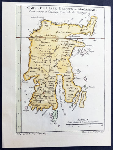
1752 Bellin Antique Map of the Island of Sulawesi, formerly Celebes, Indonesia
- Title: Carte De L'Isle Celebes ou Macassar...S Bellin
- Date: 1752
- Condition : (A+) Fine Condition
- Ref: 60919
- Size: 10in x 7 1/2in (255m x 190mm)
Description:
This fine, original copper-plate engraved antique map of the Indonesian Island of Sulawesi, formerly known as Celebes, by Jacques Nicolas Bellin in 1752 was published in Antoine François Prevosts 15 volumes of Histoire Generale des Voyages written by Prevost & other authors between 1746-1790.
Sulawesi, formerly known as Celebes, is one of the four Greater Sunda Islands, and the world\'s eleventh-largest island, it is situated east of Borneo, west of the Maluku Islands, and south of Mindanao and the Sulu Archipelago. Within Indonesia, only Sumatra, Borneo and Papua are larger in territory, and only Java and Sumatra have larger populations.
Starting in the 13th century, access to prestige trade goods and to sources of iron started to alter long-standing cultural patterns and to permit ambitious individuals to build larger political units. It is not known why these two ingredients appeared together; one was perhaps the product of the other.
In 1367, several identified polities, located on the island, were mentioned in the Javanese manuscript Nagarakretagama dated from the Majapahit period. Canto 14 mentioned polities including Gowa, Makassar, Luwu and Banggai. It seems that by the 14th century, polities in the island were connected in an archipelagic maritime trading network, centered in the Majapahit port in East Java. By 1400, a number of nascent agricultural principalities had arisen in the western Cenrana valley, as well as on the south coast and on the west coast near modern Parepare.
The first Europeans to visit the island (which they believed to be an archipelago due to its contorted shape) were the Portuguese sailors Simão de Abreu, in 1523, and Gomes de Sequeira (among others) in 1525, sent from the Moluccas in search of gold, which the islands had the reputation of producing. A Portuguese base was installed in Makassar in the first decades of the 16th century, lasting until 1665, when it was taken by the Dutch. The Dutch had arrived in Sulawesi in 1605 and were quickly followed by the English, who established a factory in Makassar. From 1660, the Dutch were at war with Gowa, the major Makasar west coast power. In 1669, Admiral Speelman forced the ruler, Sultan Hasanuddin, to sign the Treaty of Bongaya, which handed control of trade to the Dutch East India Company. The Dutch were aided in their conquest by the Bugis warlord Arung Palakka, ruler of the Bugis kingdom of Bone. The Dutch built a fort at Ujung Pandang, while Arung Palakka became the regional overlord and Bone the dominant kingdom. Political and cultural development seems to have slowed as a result of the status quo.
General Definitions:
Paper thickness and quality: - Heavy and stable
Paper color : - off white
Age of map color: - Early
Colors used: - Green, Yellow,
General color appearance: - Authentic
Paper size: - 10in x 7 1/2in (255m x 190mm)
Plate size: - 9in x 6 1/2in (230mm x 160mm)
Margins: - Min 1/2in (6mm)
Imperfections:
Margins: - None
Plate area: - None
Verso: - None
Background:
One of Antoine Francois Prevosts monumental undertakings was his history of exploration & discovery in 15 volumes titledHistoire Générale des Voyages written between 1746-1759 and was extended to 20 volumes after his death by various authors.
The 20 volumes cover the early explorations & discoveries on 3 continents: Africa (v. 1-5), Asia (v. 5-11), and America (v. 12-15) with material on the finding of the French, English, Dutch, and Portugese.
A number of notable cartographers and engravers contributed to the copper plate maps and views to the 20 volumes including Nicolas Bellin, Jan Schley, Chedel, Franc Aveline, Fessard, and many others.
The African volumes cover primarily coastal countries of West, Southern, and Eastern Africa, plus the Congo, Madagascar, Arabia and the Persian Gulf areas.
The Asian volumes cover China, Korea, Tibet, Japan, Philippines, and countries bordering the Indian Ocean.
Volume 11 includes Australia and Antarctica.
Volumes 12-15 cover voyages and discoveries in America, including the East Indies, South, Central and North America.
Volumes 16-20 include supplement volumes & tables along with continuation of voyages and discoveries in Russia, Northern Europe, America, Asia & Australia.
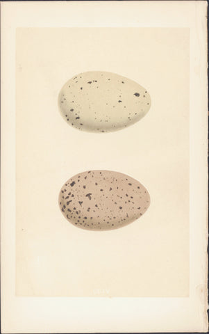
1856 Morris Antique Ornithogical Print Eggs of Black Throated & Red Throated Diver
- Title : CCIV
- Date : 1856
- Condition: (A+) Fine Condition
- Ref: 90418
- Size: 9 3/4in x 6 1/4in (250mm x 160mm)
Description:
This fine original, antique hand coloured engraved print, the Eggs of Morris Birds - (top) Black-Throated Diver (below) Red Throated Diver ; Plate CCIV from Volume III, was published in the 1856 edition of Francis Morris 'A Natural History of the Nest and Eggs of British Birds'
A History of British Birds - The inspiration for Francis Orpen Morris' A History of British Birds actually came from the renowned English printer, Benjamion Fawcett, who approached Morris to write the text when Morris became Vicar of Nafferton. Morris had a reputation as a popular writer on natural history in general and birds in particular. His first book had appeared as early as 1834, a guide to an arrangement of British birds. However, his association with Benjamin Fawcett was to have remarkable results, particularly for the study of ornithology.
History of British Birds was entirely printed and bound in the small North Country village of Driffield, Fawcett’s residence and shop, and shipped in tea chests to London. It was a resounding success.
Work on A History of British Birds probably began in 1848. Publication, which took over seven years to complete from June 1850, was undertaken in monthly parts costing one shilling. Each part contained 24 pages of letterpress and 4 hand-coloured plates. The final six volume work contained 358 coloured plates. One thousand copies of the first part were initially produced, but such was the demand that Fawcett quickly had to move into larger premises.
Alexander Francis Lydon was one of Fawcett’s principal engravers, contributing much in technique and design A team of women colourists under very strict scrutiny first from Fawcett then his wife (a former colourist herself) hand coloured each plate. Morris became an early advocate for conservation and was instrumental in founding the Royal Society for the Protection of Birds.
General Description: Paper thickness and quality: - Heavy & stable
Paper color: - White
Age of map color: - Original
Colors used: - Yellow, brown,
General color appearance: - Authentic
Paper size: - 9 3/4in x 6 1/4in (250mm x 160mm)
Plate size: - 9 3/4in x 6 1/4in (250mm x 160mm)
Margins: - Min 1/2in (12mm)
Imperfections:
Margins: - None
Plate area: - None
Verso: - None
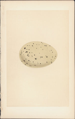
1856 Morris Antique Ornithogical Print The Eggs of Great Northern Diver or Loon
- Title : CCII
- Date : 1856
- Condition: (A+) Fine Condition
- Ref: 90418
- Size: 9 3/4in x 6 1/4in (250mm x 160mm)
Description:
This fine original, antique hand coloured engraved print, the Eggs of Great Northern Diver or Loon; Plate CCIII from Volume III, was published in the 1856 edition of Francis Morris 'A Natural History of the Nest and Eggs of British Birds'
A History of British Birds - The inspiration for Francis Orpen Morris' A History of British Birds actually came from the renowned English printer, Benjamion Fawcett, who approached Morris to write the text when Morris became Vicar of Nafferton. Morris had a reputation as a popular writer on natural history in general and birds in particular. His first book had appeared as early as 1834, a guide to an arrangement of British birds. However, his association with Benjamin Fawcett was to have remarkable results, particularly for the study of ornithology.
History of British Birds was entirely printed and bound in the small North Country village of Driffield, Fawcett’s residence and shop, and shipped in tea chests to London. It was a resounding success.
Work on A History of British Birds probably began in 1848. Publication, which took over seven years to complete from June 1850, was undertaken in monthly parts costing one shilling. Each part contained 24 pages of letterpress and 4 hand-coloured plates. The final six volume work contained 358 coloured plates. One thousand copies of the first part were initially produced, but such was the demand that Fawcett quickly had to move into larger premises.
Alexander Francis Lydon was one of Fawcett’s principal engravers, contributing much in technique and design A team of women colourists under very strict scrutiny first from Fawcett then his wife (a former colourist herself) hand coloured each plate. Morris became an early advocate for conservation and was instrumental in founding the Royal Society for the Protection of Birds.
General Description: Paper thickness and quality: - Heavy & stable
Paper color: - White
Age of map color: - Original
Colors used: - Yellow, brown,
General color appearance: - Authentic
Paper size: - 9 3/4in x 6 1/4in (250mm x 160mm)
Plate size: - 9 3/4in x 6 1/4in (250mm x 160mm)
Margins: - Min 1/2in (12mm)
Imperfections:
Margins: - None
Plate area: - None
Verso: - None
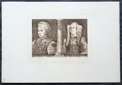
1870 Amand-Durand after Baccio Baldini Antique Print Ludovico Gonzaga III & Wife
- Title : Ludovico Gonzaga III and his Wife
- Date : 1870
- Condition: (A+) Fine Condition
- Ref: 22042
- Size: 13 1/2in x 9 1/2in (345mm x 240mm)
Description:
This fine, original antique Heliograph of Ludovico Gonzaga III and his Wife, Barbara of Brandenburg, by the Italian engraver Andrea Mantegna in the 15th century was re-engraved and published by Charles Amand-Durand in 1870.
These faithful re-engravings of classic and historical wood-cuts were faithfully re-issued by Amand-Durand in Paris in the mid to late 19th century. Such is the quality of his re-strikes that Durands prints are now in major institutional collections such a the Louvre, National Gallery, The Met and many other famous Galleries. Please see below for further background on Amand-Durand.
General Definitions:
Paper thickness and quality: - Heavy and stable
Paper color : - off white
Age of map color: -
Colors used: -
General color appearance: -
Paper size: - 13 1/2in x 9 1/2in (345mm x 240mm)
Plate size: - 8in x 6in (205mm x 1530mm)
Margins: - Min 1in (25mm)
Imperfections:
Margins: - None
Plate area: - None
Verso: - None
Background:
Andrea Mantegna 1431 – 1506 was an Italian painter, a student of Roman archeology, and son-in-law of Jacopo Bellini. Like other artists of the time, Mantegna experimented with perspective, e.g. by lowering the horizon in order to create a sense of greater monumentality. His flinty, metallic landscapes and somewhat stony figures give evidence of a fundamentally sculptural approach to painting. He also led a workshop that was the leading producer of prints in Venice before 1500.
Mantegna was no less eminent as an engraver, though his history in that respect is somewhat obscure, partly because he never signed or dated any of his plates, but for a single disputed instance of 1472. The account which has come down to us from Vasari (as usual keen to assert that everything flows from Florence) is that Mantegna began engraving in Rome, prompted by the engravings produced by the Florentine Baccio Baldini after Sandro Botticelli. This is now considered most unlikely as it would consign all the numerous and elaborate engravings made by Mantegna to the last sixteen or seventeen years of his life, which seems a scanty space for them, and besides the earlier engravings indicate an earlier period of his artistic style. He may have begun engraving while still in Padua, under the tuition of a distinguished goldsmith, Niccolò. He and his workshop engraved about thirty plates, according to the usual reckoning; large, full of figures, and highly studied. It is now considered either that he only engraved seven himself, or none. Another artist from the workshop who made several plates is usually identified as Giovanni Antonio da Brescia (aka Zoan Andrea).
Among the principal examples are: Battle of the Sea Monsters, Virgin and Child, a Bacchanal Festival, Hercules and Antaeus, Marine Gods, Judith with the Head of Holophernes, the Deposition from the Cross, the Entombment, the Resurrection, the Man of Sorrows, the Virgin in a Grotto, and several scenes from the Triumph of Julius Caesar after his paintings. Several of his engravings are supposed to be executed on some metal less hard than copper. The technique of himself and his followers is characterized by the strongly marked forms of the design, and by the parallel hatch marks to produce shadows. The closer the parallel marks, the darker the blacks were. The prints are frequently to be found in two states, or editions. In the first state the prints have been taken off with the roller, or even by handpressing, and they are weak in tint; in the second state the printing press has been used, and the ink is stronger.
Neither Mantegna or his workshop are now believed to have produced the so-called Mantegna Tarocchi cards.
Ludovico III Gonzaga of Mantua, also spelled Lodovico 1412 – 1478 was the ruler of the Italian city of Mantua from 1444 to his death in 1478.
Ludovico was the son of Gianfrancesco I Gonzaga and Paola Malatesta.
Ludovico followed the path of his father, Gianfrancesco, fighting as a condottiero from as early as 1432, when Gianfrancesco was vice-commander of Francesco Bussone\'s army. In 1433, he married Barbara of Brandenburg, niece of emperor Sigismund.
Starting from 1436 (perhaps without the approval of his father) he entered the service of the Visconti of the Duchy of Milan. The result was that Gianfrancesco exiled Ludovico from Mantua, together with his wife, naming Carlo Gonzaga as heir. However, in 1438 Gianfrancesco himself was hired by the Visconti, and reconciled with Ludovico in 1441. Ludovico succeeded to the marquisate of Mantua in 1444, although part of the family fiefs went to his brothers Carlo, Gianlucido and Alessandro. At the time, the Mantuan state was reduced in size and in poor conditions after years of war and large expenses.
From 1445 to 1450 Ludovico served as condottiero for Milan, Florence, Venice and Naples, switching his allegiance in order to grant the higher level of peace for his lands. In 1448 he took part in the battle of Caravaggio, and was forced to flee. In 1449 he entered the service of Venice in the league formed with Florence against Milan. In 1450 he received permission to lead an army for King Alfonso of Naples in Lombardy, with the intent of gaining some possessions for himself. However, Francesco Sforza, the new duke of Milan, enticed him with the promise of Lonato, Peschiera and Asola, formerly Mantuan territories but then part of Venice. Venice responded by sacking Castiglione delle Stiviere (1452) and hiring Ludovico\'s brother, Carlo.
On 14 June 1453 Ludovico routed the troops of Carlo at Goito, but Venetian troops under Niccolò Piccinino thwarted any attempt to regain Asola. The Peace of Lodi (1454) obliged Ludovico to give back all his conquests, and to renounce definitively his claim to the three cities. However, he obtained his brother\'s land after Carlos childless death in 1456.
The moment of highest prestige for Mantua was the Council, held in the city from 27 May 1459 to 19 January 1460, summoned by Pope Pius II to launch a crusade against the Ottoman Turks, who had conquered Constantinople some years earlier. However, the pope was not satisfied with the host city, writing: The place was marshy and unhealthy, and the heat burnt up everything; the wine was unpalatable and the food unpleasant. However, the council ended on a note of great personal prestige for Ludovico with the elevation of his son Francesco to the purple.
From 1466 Ludovico was more or less constantly at the service of the Sforza of Milan. He died in Goito in 1478, during a plague. He was buried in Mantua cathedral
1870 Amand-Durand after Van Leyden Antique Print The Annunciation to Virgin Mary
- Title : Heliogravure et imp A. Durand...Paris
- Date : 1870
- Condition: (A+) Fine Condition
- Ref: 22445
- Size: 14in x 9 1/2in (350mm x 240mm)
Description:
This fine, original antique Heliograph of The Annunciation, the Virgin Mary visited by the Angel Gabriel by Lucas Van Leyden (1494 - 1533) in 1508 was re-engraved and published by Charles Amand-Durand in 1870.
These faithful re-engravings of classic and historical wood-cuts were faithfully re-issued by Amand-Durand in Paris in the mid to late 19th century. Such is the quality of his re-strikes that Durands prints are now in major institutional collections such a the Louvre, National Gallery, The Met and many other famous Galleries. Please see below for further background on Amand-Durand.
General Definitions:
Paper thickness and quality: - Heavy and stable
Paper color : - off white
Age of map color: -
Colors used: -
General color appearance: -
Paper size: - 13 1/2in x 9 1/2in (345mm x 240mm)
Plate size: - 8in x 6in (205mm x 1530mm)
Margins: - Min 1in (25mm)
Imperfections:
Margins: - None
Plate area: - None
Verso: - None
Lucas van Leyden (1494 – 1533), also named either Lucas Hugensz or Lucas Jacobsz, was a Dutch engraver and painter. He was among the first Dutch exponents of genre painting and is generally regarded as a very accomplished engraver.
Lucas was the son of Huygh Jacobsz. and was mainly active in Leiden.
Carel van Mander characterizes Lucas as a tireless artist, who as a child annoyed his mother by working long hours after nightfall, which she forbid not only for the cost of candlelight, but also because she felt that too much study was bad for his sensibilities. According to Van Mander, as a boy he only consorted with other young artists, such as painters, glass-etchers and goldsmiths, and was paid by the Heer van Lochorst (Johan van Lockhorst of Leiden, who died in 1510) a golden florin for each of his years at age 12 for a watercolor of St. Hubert.
From 1513 to 1517, Lucas created a series of woodcuts called The Power of Women which consisted of two large and small sets of prints. The series is one of a number of representations of the Power of Women theme, which was extremely popular in Renaissance art and literature. Artworks in the genre depict the traditional roles of men and women in inverse, with women dominating over men in various situations. The subjects illustrated often consist of legendary historical women who were considered to be virtuous heroines as well as women who were considered cunning, seductive, and manipulative of men. The purpose of the Power of Women theme was to demonstrate that even the strongest and wisest of men were not resistant to the sexuality of women.
The Annunciation (from Latin annuntiatio), also referred to as The Annunciation to the Blessed Virgin Mary, the Annunciation of Our Lady, or the Annunciation of the Lord, is the Christian celebration of the announcement by the angel Gabriel to the Virgin Mary that she would conceive and become the mother of Jesus, the Son of God, marking his Incarnation. Gabriel told Mary to name her son Yeshua, meaning YHWH is salvation.
According to Luke 1:26, the Annunciation occurred in the sixth month of Elizabeth\'s pregnancy with John the Baptist. Many Christians observe this event with the Feast of the Annunciation on 25 March, an approximation of the northern vernal equinox nine full months before Christmas, the ceremonial birthday of Jesus. The Annunciation is a key topic in Christian art in general, as well as in Marian art in the Catholic Church, particularly during the Middle Ages and Renaissance. A work of art depicting the Annunciation is sometimes itself called an Annunciation.
1870 Amand-Durand after Heinrich Aldegrever Antique Print - Parable of Lararus
- Title : Erumnos hic lazar iages ad ianva divitis/Dives epvlo elamis
- Date : 1870
- Condition: (A+) Fine Condition
- Ref: 22444
- Size: 13 1/2in x 9 1/2in (345mm x 240mm)
Description:
This fine, original antique Heliograph two panels of the parable of The Rich Man and Lazarus or Dives and Lazarus or Lazarus and Dives by the German engraver Heinrich Aldegrever or Aldegraf in the early 16th century was re-engraved and published by Charles Amand-Durand in 1870.
These faithful re-engravings of classic and historical wood-cuts were faithfully re-issued by Amand-Durand in Paris in the mid to late 19th century. Such is the quality of his re-strikes that Durands prints are now in major institutional collections such a the Louvre, National Gallery, The Met and many other famous Galleries. Please see below for further background on Amand-Durand.
General Definitions:
Paper thickness and quality: - Heavy and stable
Paper color : - off white
Age of map color: -
Colors used: -
General color appearance: -
Paper size: - 13 1/2in x 9 1/2in (345mm x 240mm)
Plate size: - 8in x 6in (205mm x 1530mm)
Margins: - Min 1in (25mm)
Imperfections:
Margins: - None
Plate area: - None
Verso: - None
Background:
Heinrich Aldegrever or Aldegraf (1502–1561) was a German painter and engraver. He was one of the Little Masters, the group of German artists making small old master prints in the generation after Dürer.
Painter, printmaker and goldsmith active in a Westphalia milieu. Born in Paderborn. His real name was Trippenmecker, which in Westphalian dialect means a clog-maker. It is not known where Aldegrever was taught. He probably worked in a workshop of one of the Soest goldsmiths. His early works show a strong Westphalian influence. Aldegrever made a journey to the Netherlands, where he became acquainted with works of Joos van Cleve, Barendt van Orley, Lucas van Leyden and Jacob Cornelisz.
Around 1525 he moved to Soest, where a year later he painted the wings and predella of the Mary altar for the church of St. Peter. His signature and symbolic clog show that he was still using his fathers name.
His first engravings appeared in 1527. They were signed with a monogram AG, resembling closely that of Albrecht Dürer. In 1531, influenced by surrounding religious fervour, he became a Lutheran. Because of lack of church commissions he devoted most of his time to portrait painting and printmaking. Aldegrevers some 290 engravings and woodcuts, chiefly from his own designs, are delicate and minute, though somewhat hard in style, and entitle him to a place in the front rank of the so-called Little Masters: Barthel Beham, his brother Hans Sebald Beham, and Georg Pencz, with whom he is often compared. Like them, he was also a skilled ornament designer. From the close resemblance of his style to that of Albrecht Dürer he has also sometimes been called the Albert of Westphalia.
About a third of his prints were ornamental engravings; they were used as models by artists and craftsmen well into the seventeenth century.
Aldegrever, who actively supported the Reformation, executed portraits of Martin Luther and Philip Melanchthon. Although he chose the Lutheran Church, he had friends among the Anabaptists. He was commissioned by the bishop of Münster in 1535–36 to engrave portraits of Anabaptist leaders Jan van Leyden and Bernhard Knipperdolling, although they were already imprisoned, and only caricatures of them circulated. In the cycle Power of Death, done under visible influence of Hans Holbein, he criticizes the vices of the Catholic Church.
Aldegrever was interested also in folk subjects. In 1538 and 1551 two series of prints depicting marriage dances were made. An important part of his oeuvre are prints on mythological subjects, the Deeds of Hercules being one of the best examples.
Only two paintings are firmly attributed to him: the wings and predella of the Marienaltar (c. 1525-6) in the Wiesenkirche in Soest, and a portrait of Graf Phillip von Waldeck (1837) in Schloss Aroldsen
The parable of the rich man and Lazarus(also called the Dives and Lazarus or Lazarus and Dives) is a well-known parable of Jesus appearing in the Gospel of Luke.
The Gospel of Luke (Luke 16:19–31) tells of the relationship, during life and after death, between an unnamed rich man and a poor beggar named Lazarus. The traditional name Dives is not actually a name, but instead a word for rich man, dives in the text of the Latin Bible, the Vulgate. The rich man was also given the names Neuēs (i.e. Nineveh) and Fineas (i.e. Phineas) in the 3rd and 4th centuries.
Along with the parables of the Ten Virgins, Prodigal Son, and Good Samaritan, it was one of the most frequently illustrated parables in medieval art, perhaps because of its vivid account of an afterlife.
1870 Charles Amand-Durand after Johann Ladenspelder Antique Print #49 Tarot Card
- Title : Primo Mobile XXXXVIIII
- Date : 1870
- Condition: (A+) Fine Condition
- Ref: 22400
- Size: 13 1/2in x 9 1/2in (345mm x 240mm)
Description:
This fine, original antique Heliograph of card #49 of the Mantegna Tarocchi or Tarot Cards by the German engraver Johann Ladenspelder in the mid 16th century was re-engraved and published by Charles Amand-Durand in 1870.
These faithful re-engravings of classic and historical wood-cuts were faithfully re-issued by Amand-Durand in Paris in the mid to late 19th century. Such is the quality of his re-strikes that Durands prints are now in major institutional collections such a the Louvre, National Gallery, The Met and many other famous Galleries. Please see below for further background on Amand-Durand.
General Definitions:
Paper thickness and quality: - Heavy and stable
Paper color : - off white
Age of map color: -
Colors used: -
General color appearance: -
Paper size: - 13 1/2in x 9 1/2in (345mm x 240mm)
Plate size: - 8in x 6in (205mm x 1530mm)
Margins: - Min 1in (25mm)
Imperfections:
Margins: - None
Plate area: - None
Verso: - None
Background:
Johann (Hans) Ladenspelder 1512 - 1574 (aka Hans of Essen) was a german printmaker and engraver. He is particularly known for engraving a copy of a complete set (E series) of Mantegna Tarocchi cards, one of the earliest complete sets still extant.
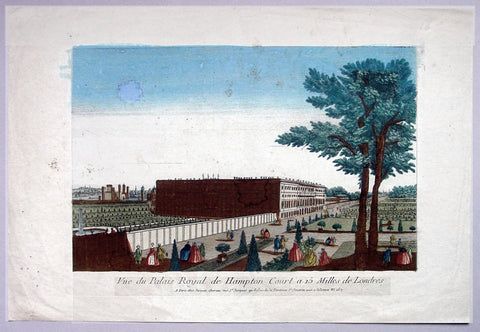
1760 Vue D Optic Antique Print View of Hampton Court Palace, Richmond London
- Title : Vue du Palias Royal de Hampton Court a 15 Milles de Londres
- Date : 1760
- Condition: (A) Very Good Condition
- Ref: 92704
- Size: 19in x 12 3/4in (480mm x 325mm)
Description:
This hand coloured original antique print, a view of Hampton Court Palace was published as part of the Vues d’Optique in 1760.
Hampton Court Palace: is a royal palace in the London Borough of Richmond upon Thames, Greater London, in the historic county of Middlesex, and within the postal town East Molesey, Surrey. It has not been inhabited by the British Royal Family since the 18th century. The palace is 11.7 miles (18.8 kilometres) south west of Charing Cross and upstream of central London on the River Thames. It was originally built in 1514 for Cardinal Thomas Wolsey, a favourite of King Henry VIII. In 1529, as Wolsey fell from favour, the King seized the palace for himself and later enlarged it. Along with St. James's Palace, it is one of only two surviving palaces out of the many owned by King Henry VIII.
In the following century, King William III's massive rebuilding and expansion project was intended to rival Versailles. Work ceased in 1694, leaving the palace in two distinct contrasting architectural styles, domestic Tudor and Baroque. While the palace's styles are an accident of fate, a unity exists due to the use of pink bricks and a symmetrical, if vague, balancing of successive low wings.
Vues d' Optique or Perspective Views: Perspective views, or "vues d'optique," are a special type of popular print published in Europe during the 18th century. These prints provided a form of entertainment when viewed through a device called an "optical machine" or an "optique." The most characteristic feature of the perspective views is their emphasized linear perspective, done to further intensify the enhanced appearance of depth and illusionistic space in the prints when viewed through an optique. When displayed in the optique, the prints might transport the viewer into a far away place---an unknown city, or perhaps into the midst of a dramatic bit of contemporary history. Another attribute of these prints is their bright, often heavy hand coloring, applied boldly so as to show the tints when viewed through the lens.
A number of perspective prints depicted American scenes at the time of the Revolution for a European audience hungry for news of the events in the British colonies. As documents of American history and European printmaking, these are unusual and appealing eighteenth-century prints.
General Description:
Paper thickness and quality: - Heavy & stable
Paper color: - Off white
Age of map color: - Original
Colors used: - Blue, yellow, green, red
General color appearance: - Authentic & bright
Paper size: - 19in x 12 3/4in (480mm x 325mm)
Plate size: - 14 1/2in x 9 1/2in (370mm x 240mm)
Margins: - Min 2in (50mm)
Imperfections:
Margins: - Light soiling
Plate area: - Small smudge & toning to sky
Verso: - Small repair, no loss
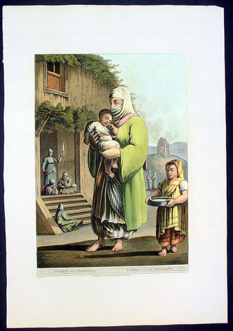
1803 Mayer Large Antique Print of a Woman & Child of Karaman, Turkey
- Title : Woman of Caramania
- Date : 1803
- Condition: (A+) Fine Condition
- Ref: 92705
- Size: 19 1/2in x 13in (485mm x 330mm)
Description:
This large fine beautifully coloured original early antique aquatint of a woman and children of the ancient southern Turkish region of Caramania (Karaman) was engraved in 1803 - the date is engraved at the foot of the image - and was published in Luigi Mayer's "Views in Egypt, Palestine and Other Parts of the Ottoman Empire" R Bowyer, Historic Gallery Pall Mall.
This engraving is characteristic of those made during Regency period, a time of exploration of the Middle East spurred by Napoleon's explorations and conquests in Egypt. Often these expeditions were published as books, containing descriptions and illustrations of the ancient architecture, customs and culture of indigenous peoples.
Italian orientalist Luigi Mayer, active in the 18th and begin 19th century travelled extensively in the middle east. His work "Views in Egypt, Palestine and Other Parts of the Ottoman Empire" was published between 1801 and 1804 with historical observations, and incidental illustrations of the manners and customs of the natives of that country. During Mayer’s time, while Britain and France were vying for control of colonial territories, Views in Egypt captivated and informed audiences in Europe about the country’s prevailing culture and even political structures. "Mamalukes exercising in the Square of Muurad Bey’s Palace," for instance, provides a valuable visual record of the military elite’s training exercises, and perhaps a hint of the Ottoman ruler’s efforts to impose centralized authority. Such highly descriptive drawings continue to make the volume an invaluable primary source.
The aquatint engraver, Thomas Milton studied under William Woollett, and was extolled by scholar W. Bell Scott as having "a unique power of distinguishing the foliage of trees and the texture of bodies, especially water, as it never had been done before, and never will be done again." (Ref: Abbey, Travel, 369. Blackmer 1097. Colas 2018-2022. Gay 2145. Hiler, pp. 577-8. HBS 15571)
General Description:
Paper thickness and quality: - Haevy and stable
Paper color: - off white
Age of map color: - Early
Colors used: - Yellow, green, pink, orange
General color appearance: - Authentic
Paper size: - 18 1/2 in x 13in (460mm x 330mm)
Plate size: - 15 in x 12in (380mm x 305mm)
Margins: - Min 1in (25mm)
Imperfections:
Margins: None
Plate area: None
Verso: None
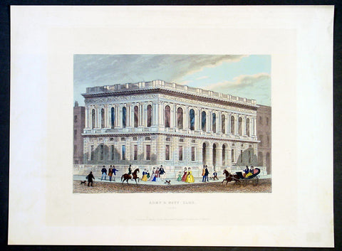
1851 Shepherd Antique Print of The Army & Navy Club, London
- Title : Army & Navy Club, Pall Mall
- Date : 1851
- Condition: (A+) Fine Condition
- Ref: 92679
- Size: 14 1/2in x 11in (370mm x 280mm)
Description:
This finely engraved beautifully hand coloured original antique print of the Army & Navy Club, or The Rag as it is known, in Pall Mall, London was engraved John Shepherd and published in the The World's Metropolis, or Mighty London, Illustrated by a Series of Views Beautifully Engraved on Steel, London 1851-1855.
Founded in August 1837, the year Queen Victoria acceded to the Throne, the Club was formed to meet the needs of the many army officers wanting to join a Service Club, most of which were already full. The great Duke of Wellington said he would become neither a patron nor a Member unless membership was also offered to officers of the Royal Navy and Royal Marines. Hence, the "Army Club" became the Army and Navy Club.
The Club's distinguished forebears include Lieutenant General Sir Edward Barnes, the first President who, as Adjutant General, fought, sword in hand, at the Battle of Waterloo, and Admiral Sir Philip Durham, one of Nelson's "Band of Brothers" who commanded HMS Defiance at the Battle of Trafalgar. Shortly after opening, the Club acquired its famous nickname, when Captain William (Billy) Higginson Duff, a colourful character with a brief and undistinguished military career was offended by the spartan nature of the fare offered to him on returning from a spree. He described the Club as a ‘Rag and Famish affair’ which was intended as a great insult, since the ‘Rag and Famish’ was a squalid gaming house ‘for broken down gamblers who played for coppers’. The Members were amused rather than insulted by this and formed a ‘Rag and Famish’ dining club. The name was gradually adopted as the Club’s nickname, eventually being reduced to ‘The Rag’. Captain Duff’s behaviour did not improve and he was later sentenced to six months in jail for assaulting a constable
General Description:
Paper thickness and quality: - Heavy & stable
Paper color: - White
Age of map color: - Original
Colors used: - Yellow, brown
General color appearance: - Authentic
Paper size: - 14 1/2in x 11in (370mm x 280mm)
Margins: - Min 1in (25mm)
Imperfections:
Margins: - None
Plate area: - None
Verso: - None
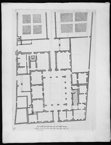
1665 De Rossi Original Antique Architectural Plan, Print of Galleria Spada, Rome Italy
- Title : Pianta Del Palazzo Del Em. Sigre Cardle Spada
- Date : 1665
- Condition: (A+) Fine Condition
- Ref: 91178
- Size: 18in x 14in (460mm x 360mm)
Description:
This finely engraved original 1655 antique architectural engraving a plan of the Galleria Spada Museum in Rome, Italy by Giovanni Battistaa Falda was published by Giacomo de Rossi in the 1665 edition of Il nuovo teatro delle fabriche, et edificii, in prospettiva di Roma moderna, 1665-1699.
These original prints are published on beautiful heavy clean original 17th century laid Italian made paper.
Galleria Spada is a museum in Rome (Italy), which is housed in the Palazzo Spada of the same name, located in the Piazza Capo di Ferro. The palazzo is also famous for its façade and for the forced perspective gallery by Francesco Borromini. The gallery exhibits paintings from the 16th and 17th century.
It was originally built in 1540 for Cardinal Girolamo Capodiferro. Bartolomeo Baronino, of Casale Monferrato, was the architect, while Giulio Mazzoni and a team provided lavish stuccowork inside and out. The palazzo was purchased by Cardinal Spada in 1632. He commissioned the Baroque architect Francesco Borromini to modify it for him, and it was Borromini who created the masterpiece of forced perspective optical illusion in the arcaded courtyard, in which diminishing rows of columns and a rising floor create the visual illusion of a gallery 37 meters long (it is 8 meters) with a lifesize sculpture at the end of the vista, in daylight beyond: the sculpture is 60 cm high. Borromini was aided in his perspective trick by a mathematician. The building was purchased in November 1926 by the Italian State to house the gallery and the State Council. The Galleria was opened in 1927 in the Palazzo Spada. It closed during the 1940s, but reopened in 1951 thanks to the efforts of the Conservator of the Galleries of Rome, Anchille Bertini Calosso and the Director, Frederico Zeri. Zeri was committed to locating the remaining artwork that had been scattered during the war, as he intended to recreate the original layout of the 16th-17th version of the gallery, including the placement of the pictures, the furniture and the sculptures. Most of the exhibited artwork comes predominantly from the private collection of Bernardino Spada, supplemented by smaller collections such as that of Virgilio Spada
General Definitions:
Paper thickness and quality: - Heavy and stable
Paper color : - off white
Age of map color: -
Colors used: -
General color appearance: -
Paper size: - 18in x 14in (460mm x 360mm)
Plate size: - 11 1/2in x 9in (290mm x 230mm)
Margins: - Min 1/2in (12mm)
Imperfections:
Margins: - None
Plate area: - None
Verso: - None
Background:
Il Nuovo Teatro: One of the most important architectural projects of the seventeenth century was the urban renovation of Rome. Under the brilliant leadership of Pope Alessandro VII (1655-1667), Rome dramatically emerged as one of the most modern and beautiful cities of the new Baroque age. Within several decades spacious roadways were constructed, monumental buildings arose, and many public squares appeared with elaborate fountains and monuments. To be sure, this massive undertaking was meant to underline the absolute power of the Papacy but it also brought forth a new flowering of Italian art and architecture.
The Nuovo Teatro was initiated in 1665 to depict the new Rome in a series of etchings. What it gave to future generations was a magnificent historical record of views etched by two of Italy's greatest architectural artists. The printing and publishing of these important etchings was entrusted to Giacomo de Rossi (1626-1691), the head of the most dominant Roman publishing house. Sons and nephews of de Rossi, in fact, continued the publishing house until 1738 when the business was sold to Pope Clement XII to form the basis of the Regia Calcografia.) Altogether, four sets of Nuovo Teatro were created during the seventeenth century. Volumes one (35 etchings) and two (17 etchings) were both published in the year of 1665 and dealt mainly in views of the new piazzas, gardens, terraces and their surrounding buildings. Volume 3 (38 etchings) was published in 1669 and concentrated upon the newly constructed churches of Rome. Every plate from the first three sets was both designed and etched by the influential architectural artist, Giovanni Battista Falda (1643-1678). For reasons unknown the fourth and final volume (52 etchings) did not appear until 1699. It was published by Giacomo's successor, Domenico de Rossi, and featured views of the palaces and stately homes of Rome. Each plate was designed and etched by the famous architect and etcher, Alessandro Specchi (1668-1729)
1665 De Rossi Original Antique Architectural Plan, Print of Poli Palace, Trevi Rome, Italy
- Title : Pianta Del Palazzo Del Duca Di Cere Alla Fontana Di Trevi
- Date : 1665
- Condition: (A+) Fine Condition
- Ref: 91179
- Size: 18in x 14in (460mm x 360mm)
Description:
This finely engraved original 1665 antique architectural plan of the Palace of the Dukes of Poli fronting the great Trevi Fountain located in Rome, Italy by Giovanni Battistaa Falda, was published by Giacomo de Rossi in the 1665 edition of Il nuovo teatro delle fabriche, et edificii, in prospettiva di Roma modernapublished between 1665-1699.
These original prints are published on beautiful heavy clean original 17th century laid Italian made paper.
The Palazzo Poli is a palace in Rome, Italy, forming the backdrop to the famous Trevi Fountain. Luigi Vanvitelli gave it a monumental facade as a setting for the fountain. It was there that Princess Zinaida Volkonskaya threw her lavish parties in the 1830s. The central portion of the palace was demolished to provide room for the large fountain in 1730.[1] The Palazzo Poli houses an important collection of copper engraving plates from the 16th century to the present.[2] The Palazzo also houses the Istituto Nazionale per la Grafica.
General Definitions:
Paper thickness and quality: - Heavy and stable
Paper color : - off white
Age of map color: -
Colors used: -
General color appearance: -
Paper size: - 18in x 14in (460mm x 360mm)
Plate size: - 11 1/2in x 9in (290mm x 230mm)
Margins: - Min 1/2in (12mm)
Imperfections:
Margins: - None
Plate area: - None
Verso: - None
Background:
Il Nuovo Teatro: One of the most important architectural projects of the seventeenth century was the urban renovation of Rome. Under the brilliant leadership of Pope Alessandro VII (1655-1667), Rome dramatically emerged as one of the most modern and beautiful cities of the new Baroque age. Within several decades spacious roadways were constructed, monumental buildings arose, and many public squares appeared with elaborate fountains and monuments. To be sure, this massive undertaking was meant to underline the absolute power of the Papacy but it also brought forth a new flowering of Italian art and architecture.
The Nuovo Teatro was initiated in 1665 to depict the new Rome in a series of etchings. What it gave to future generations was a magnificent historical record of views etched by two of Italy's greatest architectural artists. The printing and publishing of these important etchings was entrusted to Giacomo de Rossi (1626-1691), the head of the most dominant Roman publishing house. Sons and nephews of de Rossi, in fact, continued the publishing house until 1738 when the business was sold to Pope Clement XII to form the basis of the Regia Calcografia.) Altogether, four sets of Nuovo Teatro were created during the seventeenth century. Volumes one (35 etchings) and two (17 etchings) were both published in the year of 1665 and dealt mainly in views of the new piazzas, gardens, terraces and their surrounding buildings. Volume 3 (38 etchings) was published in 1669 and concentrated upon the newly constructed churches of Rome. Every plate from the first three sets was both designed and etched by the influential architectural artist, Giovanni Battista Falda (1643-1678). For reasons unknown the fourth and final volume (52 etchings) did not appear until 1699. It was published by Giacomo's successor, Domenico de Rossi, and featured views of the palaces and stately homes of Rome. Each plate was designed and etched by the famous architect and etcher, Alessandro Specchi (1668-1729)
1665 De Rossi Original Antique Architectural Plan, Print of Villa Medici Monte Pincio Italy Rome
- Title : Pianta Del Palazzo Del sermo gran Duca Di Toscana nel monte Pincio
- Date : 1665
- Condition: (A+) Fine Condition
- Ref: 91180
- Size: 18in x 14in (460mm x 360mm)
Description:
This finely engraved original 1655 antique architectural engraving a plan part of the Villa Medici on the Pincian Hill founded by Ferdinando I de' Medici, Grand Duke of Tuscany in Rome, Italy by Giovanni Battistaa Falda was published by Giacomo de Rossi in the 1665 edition of Il nuovo teatro delle fabriche, et edificii, in prospettiva di Roma moderna, 1665-1699.
These original prints are published on beautiful heavy clean original 17th century laid Italian made paper.
The Villa Medici is a mannerist villa and an architectural complex with a garden contiguous with the larger Borghese gardens, on the Pincian Hill next to Trinità dei Monti in Rome, Italy. The Villa Medici, founded by Ferdinando I de' Medici, Grand Duke of Tuscany and now property of the French State has housed the French Academy in Rome since 1803. In ancient times, the site of the Villa Medici was part of the gardens of Lucullus, which passed into the hands of the Imperial family with Messalina, who was murdered in the villa.
In 1564, when the nephews of Cardinal Giovanni Ricci of Montepulciano acquired the property, it had long been abandoned to viticulture. The sole dwelling was the Casina of Cardinale Marcello Crescenzi, who had maintained a vineyard here and had begun improvements to the villa under the direction of the Florentine Nanni Lippi, who had died however, before work had proceeded far. The new proprietors commissioned Annibale Lippi, the late architect's son, to continue work. Interventions by Michelangelo are a tradition.
In 1576, the property was acquired by Cardinal Ferdinando de' Medici, who finished the structure to designs by Bartolomeo Ammanati. The Villa Medici became at once the first among Medici properties in Rome, intended to give concrete expression to the ascendancy of the Medici among Italian princes and assert their permanent presence in Rome. Under the Cardinal's insistence, Ammanati incorporated into the design Roman bas-reliefs and statues that were coming to sight with almost every spadeful of earth, with the result that the facades of the Villa Medici, as it now was, became a virtual open-air museum. A series of grand gardens recalled the botanical gardens created at Pisa and at Florence by the Cardinal's father Cosimo I de' Medici, sheltered in plantations of pines, cypresses and oaks. Ferdinando de' Medici had a studiolo, a retreat for study and contemplation, built to the north east of the garden above the Aurelian wall. Now these rooms look onto Borghese gardens but would then have had views over the Roman countryside. These two rooms were only uncovered in 1985 by the restorer Geraldine Albers: the concealing whitewash had protected and conserved the superb fresco decoration carried out by Jacopo Zucchi 1576 and 1577.
Among the striking assemblage of Roman sculptures in the villa were some one hundred seventy pieces bought from two Roman collections that had come together through marriage, the Capranica and the della Valle collections. An engraving detailing the arrangement of statues prior to 1562 was documented by Galassi Alghisi. Three works that arrived at the Villa Medici under Cardinal Fernando, ranked with the most famous in the city: the Niobe Group and the Wrestlers, both discovered in 1583 and immediately purchased by Cardinal Ferdinando, and the Arrotino. When the Cardinal succeeded as Grand Duke of Tuscany in 1587, his elder brother having died, he satisfied himself with plaster copies of his Niobe Group, in full knowledge of the prestige that accrued to the Medici by keeping such a magnificent collection in the European city whose significance far surpassed that of their own capital. The Medici lions were completed in 1598, and the Medici Vase entered the collection at the Villa, followed by the Venus de' Medici by the 1630s; the Medici sculptures were not removed to Florence until the eighteenth century. Then the antiquities from the Villa Medici formed the nucleus of the collection of antiquities in the Uffizi, and Florence began to figure on the European Grand Tour.
The fountain in the front of the Villa Medici is formed from a red granite vase from ancient Rome. It was designed by Annibale Lippi in 1589. The view from the Villa looking over the fountain towards St Peter's in the distance has been much painted, but the trees in the foreground have now obscured the view.
Like the Villa Borghese that adjoins them, the villa's gardens were far more accessible than the formal palaces such as Palazzo Farnese in the heart of the city. For a century and a half the Villa Medici was one of the most elegant and worldly settings in Rome, the seat of the Grand Dukes' embassy to the Holy See. When the male line of the Medici died out in 1737, the villa passed to the house of Lorraine and, briefly in Napoleonic times, to the Kingdom of Etruria. In this manner Napoleon Bonaparte came into possession of the Villa Medici, which he transferred to the French Academy at Rome.
General Definitions:
Paper thickness and quality: - Heavy and stable
Paper color : - off white
Age of map color: -
Colors used: -
General color appearance: -
Paper size: - 18in x 14in (460mm x 360mm)
Plate size: - 11 1/2in x 9in (290mm x 230mm)
Margins: - Min 1/2in (12mm)
Imperfections:
Margins: - None
Plate area: - None
Verso: - None
Background:
Il Nuovo Teatro: One of the most important architectural projects of the seventeenth century was the urban renovation of Rome. Under the brilliant leadership of Pope Alessandro VII (1655-1667), Rome dramatically emerged as one of the most modern and beautiful cities of the new Baroque age. Within several decades spacious roadways were constructed, monumental buildings arose, and many public squares appeared with elaborate fountains and monuments. To be sure, this massive undertaking was meant to underline the absolute power of the Papacy but it also brought forth a new flowering of Italian art and architecture.
The Nuovo Teatro was initiated in 1665 to depict the new Rome in a series of etchings. What it gave to future generations was a magnificent historical record of views etched by two of Italy's greatest architectural artists. The printing and publishing of these important etchings was entrusted to Giacomo de Rossi (1626-1691), the head of the most dominant Roman publishing house. Sons and nephews of de Rossi, in fact, continued the publishing house until 1738 when the business was sold to Pope Clement XII to form the basis of the Regia Calcografia.) Altogether, four sets of Nuovo Teatro were created during the seventeenth century. Volumes one (35 etchings) and two (17 etchings) were both published in the year of 1665 and dealt mainly in views of the new piazzas, gardens, terraces and their surrounding buildings. Volume 3 (38 etchings) was published in 1669 and concentrated upon the newly constructed churches of Rome. Every plate from the first three sets was both designed and etched by the influential architectural artist, Giovanni Battista Falda (1643-1678). For reasons unknown the fourth and final volume (52 etchings) did not appear until 1699. It was published by Giacomo's successor, Domenico de Rossi, and featured views of the palaces and stately homes of Rome. Each plate was designed and etched by the famous architect and etcher, Alessandro Specchi (1668-1729)
1665 De Rossi Original Antique Architectural Plan, Print of Palazzo Madama Rome, Italy
- Title : Pianta Del Palazzo Del Ser G Duca Di Toscana in Piazza Madama
- Date : 1665
- Condition: (A+) Fine Condition
- Ref: 91182
- Size: 18in x 14in (460mm x 360mm)
Description:
This finely engraved original antique architectural print of the Madama Palace in Rome, Italy by Giovanni Battista Falda was published by Giacomo de Rossi in the 1665 edition of Il nuovo teatro delle fabriche, et edificii, in prospettiva di Roma moderna, 1665-1699
These original prints are published on beautiful heavy clean original 17th century laid Italian made paper.
Palazzo Madama in Rome is the seat of the Senate of the Italian Republic. It was built atop the ruins of the ancient baths of Nero, next to Piazza Navona. The terrain had been acquired in the Middle Ages by the monks of the Abbey of Farfa, who later ceded it to France.
The new building was begun at the end of the 15th century and completed in 1505, for the Medici family. It housed two Medici cardinals and cousins, Giovanni and Giulio, who both later became popes as Leo X and Clement VII, respectively. Catherine de' Medici, Clement VII's niece, also lived here before she was married to Henry, son of King Francis I of France in 1533. Cardinal Francesco Maria Del Monte, patron of the artist Caravaggio, lived there until his death in 1627.
The palace takes its name from Madama Margherita of Austria, illegitimate daughter of Emperor Charles V, who married another illegitimate son, Alessandro de' Medici and, after his death, Ottavio Farnese. Thus part of the art collection of the Florentine Medici family was inherited by the Farnese family.
The current façade was built in the mid-1650s by both Cigoliand Paolo Maruccelli. The latter added the ornate cornice and whimsical decorative urns on the roof.
After the extinction of the Medici in 1743, the palace was handed over to the House of Lorraine and, later, to Pope Benedict XIV, who made it the seat of the Papal Government. In 1849, Pius IX moved here the Ministries of Finances and of the Public Debt, as well as the Papal Post Offices. In 1871, after the conquest of Rome by the newly formed Kingdom of Italy, the palazzo became the seat of the Senato del Regno.
General Definitions:
Paper thickness and quality: - Heavy and stable
Paper color : - off white
Age of map color: -
Colors used: -
General color appearance: -
Paper size: - 18in x 14in (460mm x 360mm)
Plate size: - 11 1/2in x 9in (290mm x 230mm)
Margins: - Min 1/2in (12mm)
Imperfections:
Margins: - None
Plate area: - None
Verso: - None
Background:
Il Nuovo Teatro: One of the most important architectural projects of the seventeenth century was the urban renovation of Rome. Under the brilliant leadership of Pope Alessandro VII (1655-1667), Rome dramatically emerged as one of the most modern and beautiful cities of the new Baroque age. Within several decades spacious roadways were constructed, monumental buildings arose, and many public squares appeared with elaborate fountains and monuments. To be sure, this massive undertaking was meant to underline the absolute power of the Papacy but it also brought forth a new flowering of Italian art and architecture.
The Nuovo Teatro was initiated in 1665 to depict the new Rome in a series of etchings. What it gave to future generations was a magnificent historical record of views etched by two of Italy's greatest architectural artists. The printing and publishing of these important etchings was entrusted to Giacomo de Rossi (1626-1691), the head of the most dominant Roman publishing house. Sons and nephews of de Rossi, in fact, continued the publishing house until 1738 when the business was sold to Pope Clement XII to form the basis of the Regia Calcografia.) Altogether, four sets of Nuovo Teatro were created during the seventeenth century. Volumes one (35 etchings) and two (17 etchings) were both published in the year of 1665 and dealt mainly in views of the new piazzas, gardens, terraces and their surrounding buildings. Volume 3 (38 etchings) was published in 1669 and concentrated upon the newly constructed churches of Rome. Every plate from the first three sets was both designed and etched by the influential architectural artist, Giovanni Battista Falda (1643-1678). For reasons unknown the fourth and final volume (52 etchings) did not appear until 1699. It was published by Giacomo's successor, Domenico de Rossi, and featured views of the palaces and stately homes of Rome. Each plate was designed and etched by the famous architect and etcher, Alessandro Specchi (1668-1729)
1665 De Rossi Original Antique Architectural Plan, Print of Sachetti Palace Rome, Italy
- Title : Pianta Del Palazzo De Signori Sachetti
- Date : 1665
- Condition: (A+) Fine Condition
- Ref: 91191
- Size: 18in x 14in (460mm x 360mm)
Description:
This finely engraved original 1665 antique architectural print of the Sachetti Palace in Rome, Italy by Giovanni Battista Falda was published by Giacomo de Rossi in the 1665 edition of Il nuovo teatro delle fabriche, et edificii, in prospettiva di Roma moderna, 1665-1699.
These original prints are published on beautiful heavy clean original 17th century laid Italian made paper.
Sacchetti palace is located in Via Giulia in Rome.
Its construction was carried out by Antonio da Sangallo , who wanted to make his own home, obtaining in 1542 the land and a pre-existing unfinished house owned by the Vatican Chapter III , his principal, if not exclusive, client, to whom he dedicated The coat of arms still existing but rubbed on the main facade. At the building, the architect, who used to call the "perfect palace", spent the last years of his life especially for design until 1545 ; When he died in 1546, he went to his son Horace, and the construction was completed by Nanni of Baccio Bigio .Acquired by the Ricci di Montepulciano, who took large sums for extensions and decorative works, he later passed to the Cevoli or Ceuli family, from which he took the adjoining Alley of Cefalo; In 1608 it was bought by Cardinal Ottavio Acquaviva d'Aragona Archbishop of Napleswho before 1612, the year of his death, built the chapel frescoed by Agostino Ciampelli . In 1648 Acquaviva sold the palace to the Sacchettimarquis from Florence , who owned it in full until 2015 when part of it was sold to other owners.
The palace houses some of the most significant cycles of Mannerism , with works byFrancesco Salviati , to which the splendid frescoes of the Audience Hall (1553-1555) Pietro da Cortona andJacopino del Conte are to be found . Palazzo Sacchetti is used for the film The Great Beauty : "Viola, the rich and depressed friend, lives alone with her psychopathic son at Palazzo Sacchetti , in via Giulia, where she organizes a lunch where no one will be present
General Definitions:
Paper thickness and quality: - Heavy and stable
Paper color : - off white
Age of map color: -
Colors used: -
General color appearance: -
Paper size: - 18in x 14in (460mm x 360mm)
Plate size: - 11 1/2in x 9in (290mm x 230mm)
Margins: - Min 1/2in (12mm)
Imperfections:
Margins: - None
Plate area: - None
Verso: - None
Background:
Il Nuovo Teatro: One of the most important architectural projects of the seventeenth century was the urban renovation of Rome. Under the brilliant leadership of Pope Alessandro VII (1655-1667), Rome dramatically emerged as one of the most modern and beautiful cities of the new Baroque age. Within several decades spacious roadways were constructed, monumental buildings arose, and many public squares appeared with elaborate fountains and monuments. To be sure, this massive undertaking was meant to underline the absolute power of the Papacy but it also brought forth a new flowering of Italian art and architecture.
The Nuovo Teatro was initiated in 1665 to depict the new Rome in a series of etchings. What it gave to future generations was a magnificent historical record of views etched by two of Italy's greatest architectural artists. The printing and publishing of these important etchings was entrusted to Giacomo de Rossi (1626-1691), the head of the most dominant Roman publishing house. Sons and nephews of de Rossi, in fact, continued the publishing house until 1738 when the business was sold to Pope Clement XII to form the basis of the Regia Calcografia.) Altogether, four sets of Nuovo Teatro were created during the seventeenth century. Volumes one (35 etchings) and two (17 etchings) were both published in the year of 1665 and dealt mainly in views of the new piazzas, gardens, terraces and their surrounding buildings. Volume 3 (38 etchings) was published in 1669 and concentrated upon the newly constructed churches of Rome. Every plate from the first three sets was both designed and etched by the influential architectural artist, Giovanni Battista Falda (1643-1678). For reasons unknown the fourth and final volume (52 etchings) did not appear until 1699. It was published by Giacomo's successor, Domenico de Rossi, and featured views of the palaces and stately homes of Rome. Each plate was designed and etched by the famous architect and etcher, Alessandro Specchi (1668-1729)
1665 De Rossi Original Antique Architectural Plan, Print of Silvestri Palace Milan, Italy
- Title : Pianta Del Palazzo Dell Sig Marchese Silvestri
- Date : 1665
- Condition: (A+) Fine Condition
- Ref: 91190
- Size: 18in x 14in (460mm x 360mm)
Description:
This finely engraved original antique architectural print of the Casa Fontana Silvestri Palace in Milan, Italy by Giovanni Battistaa Falda was published by Giacomo de Rossi in the 1665 edition of Il nuovo teatro delle fabriche, et edificii, in prospettiva di Roma moderna, 1665-1699.
These original prints are published on beautiful heavy clean original 17th century laid Italian made paper.
Casa Fontana-Silvestri is one of the few Renaissance buildings surviving in Milan, Italy. The main structure dates back to the 12th century, but its current form is due to a thorough modification that were made at the end of the 14th century, in a style that mixes Renaissance and Gothic elements.
The facade was originally decorated with frescos that scholars credit to Bramante or Bramantino; most of these painting have disappeared, with just a few remnants now visible under the cornice. It has also been suggested that Bramante may have designed the cotto decorations, also on the facade.
General Definitions:
Paper thickness and quality: - Heavy and stable
Paper color : - off white
Age of map color: -
Colors used: -
General color appearance: -
Paper size: - 18in x 14in (460mm x 360mm)
Plate size: - 11 1/2in x 9in (290mm x 230mm)
Margins: - Min 1/2in (12mm)
Imperfections:
Margins: - None
Plate area: - None
Verso: - None
Background:
Il Nuovo Teatro: One of the most important architectural projects of the seventeenth century was the urban renovation of Rome. Under the brilliant leadership of Pope Alessandro VII (1655-1667), Rome dramatically emerged as one of the most modern and beautiful cities of the new Baroque age. Within several decades spacious roadways were constructed, monumental buildings arose, and many public squares appeared with elaborate fountains and monuments. To be sure, this massive undertaking was meant to underline the absolute power of the Papacy but it also brought forth a new flowering of Italian art and architecture.
The Nuovo Teatro was initiated in 1665 to depict the new Rome in a series of etchings. What it gave to future generations was a magnificent historical record of views etched by two of Italy's greatest architectural artists. The printing and publishing of these important etchings was entrusted to Giacomo de Rossi (1626-1691), the head of the most dominant Roman publishing house. Sons and nephews of de Rossi, in fact, continued the publishing house until 1738 when the business was sold to Pope Clement XII to form the basis of the Regia Calcografia.) Altogether, four sets of Nuovo Teatro were created during the seventeenth century. Volumes one (35 etchings) and two (17 etchings) were both published in the year of 1665 and dealt mainly in views of the new piazzas, gardens, terraces and their surrounding buildings. Volume 3 (38 etchings) was published in 1669 and concentrated upon the newly constructed churches of Rome. Every plate from the first three sets was both designed and etched by the influential architectural artist, Giovanni Battista Falda (1643-1678). For reasons unknown the fourth and final volume (52 etchings) did not appear until 1699. It was published by Giacomo's successor, Domenico de Rossi, and featured views of the palaces and stately homes of Rome. Each plate was designed and etched by the famous architect and etcher, Alessandro Specchi (1668-1729)
1665 De Rossi Original Antique Architectural Plan, Print of Alfieri, Asti Palace Monferrato, Italy
- Title : Pianta Del Palazzo De Sig. D ' Asti
- Date : 1665
- Condition: (A+) Fine Condition
- Ref: 91195
- Size: 18in x 14in (460mm x 360mm)
Description:
This finely engraved original antique architectural engraving a plan of the Alfieri (Asti) Palace in Monferrato, Italy by Giovanni Battistaa Falda was published by Giacomo de Rossi in the 1665 edition of Il nuovo teatro delle fabriche, et edificii, in prospettiva di Roma moderna, 1665-1699.
These original prints are published on beautiful heavy clean original 17th century laid Italian made paper.
Palazzo Alfieri (Asti)An ancient noble home from the 13th century. In 1738, the owner, Antonio Amedeo Alfieri, decided to alter the size and restore the property, an assignment which he entrusted to his illustrious cousin, Benedetto Alfieri, who had become, in the meantime, the royal architect. Benedetto began to work on the building, transforming it into a grandiose and complex palace with a trapezoid courtyard, a garden, and an imposing façade. Eleven years later, in this very palace, the great poet Vittorio Alfieri was born, who spent part of this life here until he decided to leave the sleepy province in search of more meaningful experiences.
The palace was acquired in 1901 by Conte Ottolenghi, who then donated it to the city, which turned it into a Museo in order to give the Museo Alfieriano a seat. Today, the Centro Nazionale di Studi Alfieriani (National Center of Alfierian Studies), the Biblioteca Astense (Asti Library), and the Istituto per la Storia della Resistenza (Institute for the History of the Resistance) all have their seats here.
General Definitions:
Paper thickness and quality: - Heavy and stable
Paper color : - off white
Age of map color: -
Colors used: -
General color appearance: -
Paper size: - 18in x 14in (460mm x 360mm)
Plate size: - 11 1/2in x 9in (290mm x 230mm)
Margins: - Min 1/2in (12mm)
Imperfections:
Margins: - None
Plate area: - None
Verso: - None
Background:
Il Nuovo Teatro: One of the most important architectural projects of the seventeenth century was the urban renovation of Rome. Under the brilliant leadership of Pope Alessandro VII (1655-1667), Rome dramatically emerged as one of the most modern and beautiful cities of the new Baroque age. Within several decades spacious roadways were constructed, monumental buildings arose, and many public squares appeared with elaborate fountains and monuments. To be sure, this massive undertaking was meant to underline the absolute power of the Papacy but it also brought forth a new flowering of Italian art and architecture.
The Nuovo Teatro was initiated in 1665 to depict the new Rome in a series of etchings. What it gave to future generations was a magnificent historical record of views etched by two of Italy's greatest architectural artists. The printing and publishing of these important etchings was entrusted to Giacomo de Rossi (1626-1691), the head of the most dominant Roman publishing house. Sons and nephews of de Rossi, in fact, continued the publishing house until 1738 when the business was sold to Pope Clement XII to form the basis of the Regia Calcografia.) Altogether, four sets of Nuovo Teatro were created during the seventeenth century. Volumes one (35 etchings) and two (17 etchings) were both published in the year of 1665 and dealt mainly in views of the new piazzas, gardens, terraces and their surrounding buildings. Volume 3 (38 etchings) was published in 1669 and concentrated upon the newly constructed churches of Rome. Every plate from the first three sets was both designed and etched by the influential architectural artist, Giovanni Battista Falda (1643-1678). For reasons unknown the fourth and final volume (52 etchings) did not appear until 1699. It was published by Giacomo's successor, Domenico de Rossi, and featured views of the palaces and stately homes of Rome. Each plate was designed and etched by the famous architect and etcher, Alessandro Specchi (1668-1729)
1665 De Rossi Original Antique Architectural Plan, Print of Falconieri Palace, Rome, Italy
- Title : Pianta Del Palazzo De Sig. Falconieri
- Date : 1665
- Condition: (A+) Fine Condition
- Ref: 91192
- Size: 18in x 14in (460mm x 360mm)
Description:
This finely engraved original antique architectural engraving a plan of the Falconieri Palace Rome, Italy by Giovanni Battistaa Falda was published by Giacomo de Rossi in the 1665 edition of Il nuovo teatro delle fabriche, et edificii, in prospettiva di Roma moderna, 1665-1699.
These original prints are published on beautiful heavy clean original 17th century laid Italian made paper.
Palazzo Falconieri is a palace in Rome, Italy formed in the seventeenth century as a result of remodelling by the Baroque architect Francesco Borromini. It is the home of the Hungarian Academy Rome(which is the Rome office of the Balassi Institute), since its foundation in 1927. It is located between Via Giulia and Lugotevere, with entrances to both; it is near Plazzo Farnese and a few houses down and across Via Giulia from the church of Santa Caterina a Magnanapoli in the Rione of Regola. From 1814, it was occupied by cardinal Joseph Fesch, Napoleon's uncle.
In 1638, Orazio Falconieri purchased a palace on the Via Giulia which had a small courtyard facing the River Tiber. He bought an adjacent property in 1645 and in 1646 and appointed the architect Francesco Borromini to remodel and refurbish the two. Some of Borromini’s work was lost in the nineteenth century development of Lungotevere, the embankment and road between the Tiber and the buildings which overlook it, but parts remain.
The surviving parts of Borromini’s work include the façade to the Via Giulia, the Belvedere overlooking the Tiber and the decorative work in several rooms. On the façade, the number of bays was increased from seven to eleven and at either end, tall inverted fluted pilasters were placed terminating in falcons heads, a reference to the family name, that each look back at the façade. Overlooking the Tiber, Borromini added a Belvedere, a three bay loggia with Serliana openings, that stands above the surrounding buildings. On the interior, some of the rooms are ornamented with stucco work designed by Borromini, with the frequent use of heraldic devices and symbolic motifs
General Definitions:
Paper thickness and quality: - Heavy and stable
Paper color : - off white
Age of map color: -
Colors used: -
General color appearance: -
Paper size: - 18in x 14in (460mm x 360mm)
Plate size: - 11 1/2in x 9in (290mm x 230mm)
Margins: - Min 1/2in (12mm)
Imperfections:
Margins: - None
Plate area: - None
Verso: - None
Background:
Il Nuovo Teatro: One of the most important architectural projects of the seventeenth century was the urban renovation of Rome. Under the brilliant leadership of Pope Alessandro VII (1655-1667), Rome dramatically emerged as one of the most modern and beautiful cities of the new Baroque age. Within several decades spacious roadways were constructed, monumental buildings arose, and many public squares appeared with elaborate fountains and monuments. To be sure, this massive undertaking was meant to underline the absolute power of the Papacy but it also brought forth a new flowering of Italian art and architecture.
The Nuovo Teatro was initiated in 1665 to depict the new Rome in a series of etchings. What it gave to future generations was a magnificent historical record of views etched by two of Italy's greatest architectural artists. The printing and publishing of these important etchings was entrusted to Giacomo de Rossi (1626-1691), the head of the most dominant Roman publishing house. Sons and nephews of de Rossi, in fact, continued the publishing house until 1738 when the business was sold to Pope Clement XII to form the basis of the Regia Calcografia.) Altogether, four sets of Nuovo Teatro were created during the seventeenth century. Volumes one (35 etchings) and two (17 etchings) were both published in the year of 1665 and dealt mainly in views of the new piazzas, gardens, terraces and their surrounding buildings. Volume 3 (38 etchings) was published in 1669 and concentrated upon the newly constructed churches of Rome. Every plate from the first three sets was both designed and etched by the influential architectural artist, Giovanni Battista Falda (1643-1678). For reasons unknown the fourth and final volume (52 etchings) did not appear until 1699. It was published by Giacomo's successor, Domenico de Rossi, and featured views of the palaces and stately homes of Rome. Each plate was designed and etched by the famous architect and etcher, Alessandro Specchi (1668-1729)
1665 De Rossi Original Antique Architectural Plan, Print of Barberini Palace, Rome Italy
- Title : Pianta Del Palazz Del'Gli Ecc Sig, Barberini
- Date : 1665
- Condition: (A+) Fine Condition
- Ref: 91184
- Size: 18in x 14in (460mm x 360mm)
Description:
This finely engraved original antique architectural engraving a plan of Barberini Palace Rome, Italy by Giovanni Battistaa Falda was published by Giacomo de Rossi in the 1665 edition of Il nuovo teatro delle fabriche, et edificii, in prospettiva di Roma moderna, 1665-1699.
These original prints are published on beautiful heavy clean original 17th century laid Italian made paper inlaid with a Fleur-de-Lis watermark.
The Palazzo Barberini is a 17th-century palace in Rome, facing the Piazza Barberini in Rione Trevi. It houses the Galleria Nazionale d'Arte Antica.
The sloping site had formerly been occupied by a garden-vineyard of the Sforza family, in which a palazzetto had been built in 1549. The sloping site passed from one cardinal to another during the sixteenth century, with no project fully getting off the ground.
When Cardinal Alessandro Sforza met financial hardships, the still semi-urban site was purchased in 1625 by Maffeo Barberini, of the Barberini family, who became Pope Urban VIII.
Three great architects worked to create the Palazzo, each contributing his own style and character to the building. Carlo Maderno, then at work extending the nave of St Peter's, was commissioned to enclose the Villa Sforza within a vast Renaissance block along the lines of Palazzo Farnese; however, the design quickly evolved into a precedent-setting combination of an urban seat of princely power combined with a garden front that had the nature of a suburban villa with a semi-enclosed garden.
Maderno began in 1627, assisted by his nephew Francesco Borromini. When Maderno died in 1629, Borromini was passed over and the commission was awarded to Bernini, a young prodigy then better known as a sculptor. Borromini stayed on regardless and the two architects worked together, albeit briefly, on this project and at the Palazzo Spada. Works were completed by Bernini in 1633.
After the Wars of Castro and the death of Urban VIII, the palace was confiscated by Pamphili Pope Innocent X and was only returned to the Barberini in 1653.
General Definitions:
Paper thickness and quality: - Heavy and stable
Paper color : - off white
Age of map color: -
Colors used: -
General color appearance: -
Paper size: - 18in x 14in (460mm x 360mm)
Plate size: - 11 1/2in x 9in (290mm x 230mm)
Margins: - Min 1/2in (12mm)
Imperfections:
Margins: - None
Plate area: - None
Verso: - None
Background:
Il Nuovo Teatro: One of the most important architectural projects of the seventeenth century was the urban renovation of Rome. Under the brilliant leadership of Pope Alessandro VII (1655-1667), Rome dramatically emerged as one of the most modern and beautiful cities of the new Baroque age. Within several decades spacious roadways were constructed, monumental buildings arose, and many public squares appeared with elaborate fountains and monuments. To be sure, this massive undertaking was meant to underline the absolute power of the Papacy but it also brought forth a new flowering of Italian art and architecture.
The Nuovo Teatro was initiated in 1665 to depict the new Rome in a series of etchings. What it gave to future generations was a magnificent historical record of views etched by two of Italy's greatest architectural artists. The printing and publishing of these important etchings was entrusted to Giacomo de Rossi (1626-1691), the head of the most dominant Roman publishing house. Sons and nephews of de Rossi, in fact, continued the publishing house until 1738 when the business was sold to Pope Clement XII to form the basis of the Regia Calcografia.) Altogether, four sets of Nuovo Teatro were created during the seventeenth century. Volumes one (35 etchings) and two (17 etchings) were both published in the year of 1665 and dealt mainly in views of the new piazzas, gardens, terraces and their surrounding buildings. Volume 3 (38 etchings) was published in 1669 and concentrated upon the newly constructed churches of Rome. Every plate from the first three sets was both designed and etched by the influential architectural artist, Giovanni Battista Falda (1643-1678). For reasons unknown the fourth and final volume (52 etchings) did not appear until 1699. It was published by Giacomo's successor, Domenico de Rossi, and featured views of the palaces and stately homes of Rome. Each plate was designed and etched by the famous architect and etcher, Alessandro Specchi (1668-1729)
1665 De Rossi Original Antique Architectural Plan, Print of Palazzo Valentini Rome, Italy
- Title : Pianta Del Palazzo Del Cardinale Alesandrino a SS Apostoli
- Date : 1665
- Condition: (A+) Fine Condition
- Ref: 91183
- Size: 18in x 14in (460mm x 360mm)
Description:
This finely engraved original antique architectural engraving a plan of Palazzo Valentini in central Rome, Italy by Giovanni Battistaa Falda was published by Giacomo de Rossi in the 1665 edition of Il nuovo teatro delle fabriche, et edificii, in prospettiva di Roma moderna, 1665-1699.
These original prints are published on beautiful heavy clean original 17th century laid Italian made paper inlaid with a Fleur-de-Lis watermark.
Palazzo Valentini is a palazzo in central Rome, Italy, not far from Piazza Venezia that was the residence of Carlo Michele Bonelli, Cardinal Alessandrino and his hiers in the 17th century.
The palazzo was first built by cardinal Michele Bonelli, nephew of pope Pius V, who, in 1585, acquired a pre-existing palazzo from Giacomo Boncompagni at the extremity of what was then piazza dei Santi Apostoli. Today the palazzo is separated from that piazza by via Quattro Novembre, opened later to connect the new via Nazionale with piazza Venezia. The cardinal was also the owner of a large part of the area which extended, behind the palazzo, above the ruins of the imperial foraof Trajan and Augustus, known by the name "Pantano" due to being subject to impaludamenti or flooding. Over the same years the district on the ruins of the imperial fora was subjected to a general development of the land and to a systematic urbanisation, with the creation of the "quartiere Alessandrino" in the cardinal's honour (he was nicknamed "cardinale alessandrino" after his origins in a village in the province of Alessandria). The quarter was destroyed in the 1920s and 1930s to open via dei Fori Imperiali.
The trapezoidal plan of the palazzo was designed by Domenico Paganelli. Thanks to substantial funds ploughed into the project by the cardinal, the palazzo was quickly completed within 3 years after building started. In the 17th century the building was then subject to a series of major renovations and expansions, carried out on behalf of cardinals Carlo Bonelli and Michele Ferdinando Bonelli. The palazzo was partially demolished and rebuilt by Francesco Peparelli for its new owner, cardinal Renato Imperiali, who organised the important family library (the "Imperiali") of around 24,000 volumes.
At the start of the 18th century, the palazzo was leased to several prominent personalities, including marchese Francesco Maria Ruspoli from 1705 to 1713, who made it the site for a private theatre and hosted illustrious musicians of the time such as Handel, Alessandro Scarlatti and Arcangelo Corelli. The entire building was then acquired in 1752 by cardinal Giuseppe Spinelli, who realised a new decorative scheme for the first floor and systematised the library (meant by him for public use, and frequented by Johann Joachim Winckelmann) on the ground floor.
In 1827 the Prussian banker and consul general Vincenzo Valentini acquired the palazzo, in which he settled and to which he gave his name. The palazzo was later expanded and rebuilt at great expense, and its new owner used it to house his own collection of paintings as well as increasing the palazzo's own substantial library and archaeological collection. Completion of the works at the back of the palazzo, overlooking the column of Trajan, was entrusted to the architects Filippo Navone and Giovanni Battista Benedetti. Between 1861 and 1865 Vincenzo's son Gioacchino Valentini commissioned two further expansions on the left side, along via di Sant'Eufemia, designed by the architect Luigi Gabet. The provincial deputation of Rome acquired the palazzo as their base in 1873, commissioning the architect Gabet to complete the right side on via de’ Fornari, at the top of vicolo di San Bernardo.
General Definitions:
Paper thickness and quality: - Heavy and stable
Paper color : - off white
Age of map color: -
Colors used: -
General color appearance: -
Paper size: - 18in x 14in (460mm x 360mm)
Plate size: - 11 1/2in x 9in (290mm x 230mm)
Margins: - Min 1/2in (12mm)
Imperfections:
Margins: - None
Plate area: - None
Verso: - None
Background:
Il Nuovo Teatro: One of the most important architectural projects of the seventeenth century was the urban renovation of Rome. Under the brilliant leadership of Pope Alessandro VII (1655-1667), Rome dramatically emerged as one of the most modern and beautiful cities of the new Baroque age. Within several decades spacious roadways were constructed, monumental buildings arose, and many public squares appeared with elaborate fountains and monuments. To be sure, this massive undertaking was meant to underline the absolute power of the Papacy but it also brought forth a new flowering of Italian art and architecture.
The Nuovo Teatro was initiated in 1665 to depict the new Rome in a series of etchings. What it gave to future generations was a magnificent historical record of views etched by two of Italy's greatest architectural artists. The printing and publishing of these important etchings was entrusted to Giacomo de Rossi (1626-1691), the head of the most dominant Roman publishing house. Sons and nephews of de Rossi, in fact, continued the publishing house until 1738 when the business was sold to Pope Clement XII to form the basis of the Regia Calcografia.) Altogether, four sets of Nuovo Teatro were created during the seventeenth century. Volumes one (35 etchings) and two (17 etchings) were both published in the year of 1665 and dealt mainly in views of the new piazzas, gardens, terraces and their surrounding buildings. Volume 3 (38 etchings) was published in 1669 and concentrated upon the newly constructed churches of Rome. Every plate from the first three sets was both designed and etched by the influential architectural artist, Giovanni Battista Falda (1643-1678). For reasons unknown the fourth and final volume (52 etchings) did not appear until 1699. It was published by Giacomo's successor, Domenico de Rossi, and featured views of the palaces and stately homes of Rome. Each plate was designed and etched by the famous architect and etcher, Alessandro Specchi (1668-1729)
1665 De Rossi Original Antique Architectural Plan, Print of the Giustiniani Palace in Venice, Italy
- Title : Pianta Del Palazzo Dell Ecc. Sig. Prencipe Giustiniani
- Date : 1665
- Condition: (A+) Fine Condition
- Ref: 91188
- Size: 18in x 14in (460mm x 360mm)
Description:
This finely engraved original 1665 antique architectural print of the Giustiniani Palace in Venice, Italy by Giovanni Battistaa Falda was published by Giacomo de Rossi in the 1665 edition of Il nuovo teatro delle fabriche, et edificii, in prospettiva di Roma moderna, 1665-1699.
These original prints are published on beautiful heavy clean original 17th century laid Italian made paper inlaid with a Fleur-de-Lis watermark.
Palazzo Giustinian is a palace in Venice, northern Italy, situated in the Dorsoduro district and overlooking the Grand Canal next to Ca' Foscari. It is among the best examples of the late Venetian Gothic and was the final residence of Princess Louise Marie Thérèse of France.
The edifice was built in the late 15th century, perhaps with the participation of Bartolomeo Bon. The palace consisted originally of two separated sectors, one for each branch of the family, which were later harmonized through a central section in the façade; these are known as Ca' Giustinian dei Vescovi(now housing part of the Ca' Foscari University) and Ca' Giustinian dalle Zogie (now privately owned). Behind the façade, they are separated by an alley which, through a sottoportego, or portico-tunnel, connects to the central portal.
The two sub-palaces share numerous decorative features with the annexed Ca' Foscari. They have an L-shaped plan with four floors, the upper ones having mullioned windows. At the piano nobile they form a six-arches arcade with an interwoven motif of multi-lobes circles. The single windows are ogival, or decorated with a three-lobe motif. Ca' Giustinian dei Vescovi has in the rear a court with a Gothic staircase, while Ca' Giustinian delle Zogie has a large garden.
The family sold the palazzo in the 19th century. Since then, personalities such as painter Natale Schiavoni, German composer Richard Wagner (who wrote the second act of Tristan und Isolde here between 1858 and 1859), the last Duchess of Parma, Louise d'Artois, and Hungarian violinist Franz von Vecsey have lived here
General Definitions:
Paper thickness and quality: - Heavy and stable
Paper color : - off white
Age of map color: -
Colors used: -
General color appearance: -
Paper size: - 18in x 14in (460mm x 360mm)
Plate size: - 11 1/2in x 9in (290mm x 230mm)
Margins: - Min 1/2in (12mm)
Imperfections:
Margins: - None
Plate area: - None
Verso: - None
Background:
Il Nuovo Teatro: One of the most important architectural projects of the seventeenth century was the urban renovation of Rome. Under the brilliant leadership of Pope Alessandro VII (1655-1667), Rome dramatically emerged as one of the most modern and beautiful cities of the new Baroque age. Within several decades spacious roadways were constructed, monumental buildings arose, and many public squares appeared with elaborate fountains and monuments. To be sure, this massive undertaking was meant to underline the absolute power of the Papacy but it also brought forth a new flowering of Italian art and architecture.
The Nuovo Teatro was initiated in 1665 to depict the new Rome in a series of etchings. What it gave to future generations was a magnificent historical record of views etched by two of Italy's greatest architectural artists. The printing and publishing of these important etchings was entrusted to Giacomo de Rossi (1626-1691), the head of the most dominant Roman publishing house. Sons and nephews of de Rossi, in fact, continued the publishing house until 1738 when the business was sold to Pope Clement XII to form the basis of the Regia Calcografia.) Altogether, four sets of Nuovo Teatro were created during the seventeenth century. Volumes one (35 etchings) and two (17 etchings) were both published in the year of 1665 and dealt mainly in views of the new piazzas, gardens, terraces and their surrounding buildings. Volume 3 (38 etchings) was published in 1669 and concentrated upon the newly constructed churches of Rome. Every plate from the first three sets was both designed and etched by the influential architectural artist, Giovanni Battista Falda (1643-1678). For reasons unknown the fourth and final volume (52 etchings) did not appear until 1699. It was published by Giacomo's successor, Domenico de Rossi, and featured views of the palaces and stately homes of Rome. Each plate was designed and etched by the famous architect and etcher, Alessandro Specchi (1668-1729)
1665 De Rossi Original Antique Architectural Plan, Print of Lancellotti Palace, Rome Italy
- Title : Pianta Del Palazzo De Sig. Lancello
- Date : 1665
- Condition: (A+) Fine Condition
- Ref: 91196
- Size: 18in x 14in (460mm x 360mm)
Description:
This finely engraved original 1665 antique architectural plan of the Lancellotti Palace, also known as de Torres, in Rome, Italy by Giovanni Battistaa Falda, was published by Giacomo de Rossi in the 1665 edition of Il nuovo teatro delle fabriche, et edificii, in prospettiva di Roma moderna published in its between 1665-1699.
These original prints are published on beautiful heavy clean original 17th century laid Italian made paper inlaid with a Fleur-de-Lis watermark.
Palazzo Torres Massimo Lancellotti(Lancellotti Palace, also known as de Torres) was built for the Spanish family Torres by P.Ligorio in 1560. The palace is irregular and has ten sides with the longest one on Via della Posta Vecchia. The main facades are one the Piazza Navona and Via della Cuccagna. The windows on the noble floor are of the 15th century type, while in the rest of the palace, of the 16th century.
The Palazzo Torres Lancellotti was designed by Francesco da Volterra, and completed by Carlo Maderno. The latter was most probably also responsible for the decorative scheme of the courtyard of which the collection of sculpture forms an integral part. Palazzo Mattei, also a work of Carlo Maderno, reflects similar decorative features in the courtyard and similar ideas.
Interior is characterized by beautiful halls with the carved ceilings. In the end of the 18th century the main hall was used as a theatre; and several decades before the palace housed Chamber printing-office.
The building, an example of late-Renaissance architecture, features an interesting main façade with three orders of eleven travertine windows, decorated by and topped by a cornice. The building is accessed through an imposing portal sided by columns and topped by a balcony, leading to a courtyard that has columns on one side and is decorated with plants, ancient reliefs and stuccoes.
The loggia features some statues that represent the remains of a great collection: it included the statue of Pudicitia, Diana Efesina and the bas-relief of Medea, now hosted in the Vatican Museums. Inside the palace, it is possible to admire the wonderful frescoes by Agostino Tassi and Guercino con landscapes, allegories and views.
General Definitions:
Paper thickness and quality: - Heavy and stable
Paper color : - off white
Age of map color: -
Colors used: -
General color appearance: -
Paper size: - 18in x 14in (460mm x 360mm)
Plate size: - 11 1/2in x 9in (290mm x 230mm)
Margins: - Min 1/2in (12mm)
Imperfections:
Margins: - None
Plate area: - None
Verso: - None
Background:
Il Nuovo Teatro: One of the most important architectural projects of the seventeenth century was the urban renovation of Rome. Under the brilliant leadership of Pope Alessandro VII (1655-1667), Rome dramatically emerged as one of the most modern and beautiful cities of the new Baroque age. Within several decades spacious roadways were constructed, monumental buildings arose, and many public squares appeared with elaborate fountains and monuments. To be sure, this massive undertaking was meant to underline the absolute power of the Papacy but it also brought forth a new flowering of Italian art and architecture.
The Nuovo Teatro was initiated in 1665 to depict the new Rome in a series of etchings. What it gave to future generations was a magnificent historical record of views etched by two of Italy's greatest architectural artists. The printing and publishing of these important etchings was entrusted to Giacomo de Rossi (1626-1691), the head of the most dominant Roman publishing house. Sons and nephews of de Rossi, in fact, continued the publishing house until 1738 when the business was sold to Pope Clement XII to form the basis of the Regia Calcografia.) Altogether, four sets of Nuovo Teatro were created during the seventeenth century. Volumes one (35 etchings) and two (17 etchings) were both published in the year of 1665 and dealt mainly in views of the new piazzas, gardens, terraces and their surrounding buildings. Volume 3 (38 etchings) was published in 1669 and concentrated upon the newly constructed churches of Rome. Every plate from the first three sets was both designed and etched by the influential architectural artist, Giovanni Battista Falda (1643-1678). For reasons unknown the fourth and final volume (52 etchings) did not appear until 1699. It was published by Giacomo's successor, Domenico de Rossi, and featured views of the palaces and stately homes of Rome. Each plate was designed and etched by the famous architect and etcher, Alessandro Specchi (1668-1729)
1665 De Rossi Original Antique Architectural Plan, Print of Millini Palace, Rome, Italy
- Title : Pianta Del Palazzo De Sig. Mellini
- Date : 1665
- Condition: (A+) Fine Condition
- Ref: 91194
- Size: 18in x 14in (460mm x 360mm)
Description:
This finely engraved original antique architectural engraving a plan of the Palace owned by the Mellini or Millini family in Rome, Italy by Giovanni Battistaa Falda was published by Giacomo de Rossi in the 1665 edition of Il nuovo teatro delle fabriche, et edificii, in prospettiva di Roma moderna, 1665-1699.
These original prints are published on beautiful heavy clean original 17th century laid Italian made paper.
General Definitions:
Paper thickness and quality: - Heavy and stable
Paper color : - off white
Age of map color: -
Colors used: -
General color appearance: -
Paper size: - 18in x 14in (460mm x 360mm)
Plate size: - 11 1/2in x 9in (290mm x 230mm)
Margins: - Min 1/2in (12mm)
Imperfections:
Margins: - None
Plate area: - None
Verso: - None
Background:
Il Nuovo Teatro: One of the most important architectural projects of the seventeenth century was the urban renovation of Rome. Under the brilliant leadership of Pope Alessandro VII (1655-1667), Rome dramatically emerged as one of the most modern and beautiful cities of the new Baroque age. Within several decades spacious roadways were constructed, monumental buildings arose, and many public squares appeared with elaborate fountains and monuments. To be sure, this massive undertaking was meant to underline the absolute power of the Papacy but it also brought forth a new flowering of Italian art and architecture.
The Nuovo Teatro was initiated in 1665 to depict the new Rome in a series of etchings. What it gave to future generations was a magnificent historical record of views etched by two of Italy's greatest architectural artists. The printing and publishing of these important etchings was entrusted to Giacomo de Rossi (1626-1691), the head of the most dominant Roman publishing house. Sons and nephews of de Rossi, in fact, continued the publishing house until 1738 when the business was sold to Pope Clement XII to form the basis of the Regia Calcografia.) Altogether, four sets of Nuovo Teatro were created during the seventeenth century. Volumes one (35 etchings) and two (17 etchings) were both published in the year of 1665 and dealt mainly in views of the new piazzas, gardens, terraces and their surrounding buildings. Volume 3 (38 etchings) was published in 1669 and concentrated upon the newly constructed churches of Rome. Every plate from the first three sets was both designed and etched by the influential architectural artist, Giovanni Battista Falda (1643-1678). For reasons unknown the fourth and final volume (52 etchings) did not appear until 1699. It was published by Giacomo's successor, Domenico de Rossi, and featured views of the palaces and stately homes of Rome. Each plate was designed and etched by the famous architect and etcher, Alessandro Specchi (1668-1729)
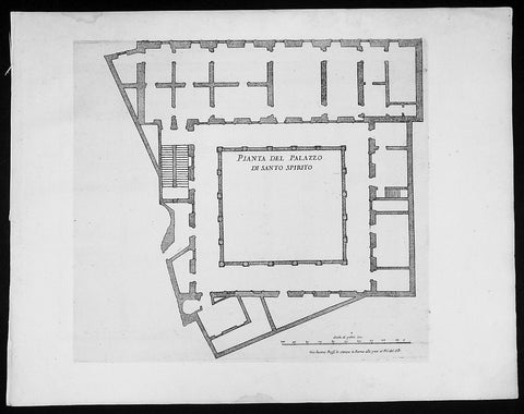
1665 De Rossi Original Antique Architectural Plan, Print of Santo Spirito Palace Florence
- Title : Pianta Del Palazzo Di Santo Spirito
- Date : 1665
- Condition: (A+) Fine Condition
- Ref: 91193
- Size: 18in x 14in (460mm x 360mm)
Description:
This finely engraved original antique architectural print of Palace Santo Spirito in the Oltrarno quarter of Florence, Italy by Giovanni Battistaa Falda was published by Giacomo de Rossi in the 1665 edition of Il nuovo teatro delle fabriche, et edificii, in prospettiva di Roma moderna, 1665-1699.
These original prints are published on beautiful heavy clean original 17th century laid Italian made paper.
General Definitions:
Paper thickness and quality: - Heavy and stable
Paper color : - off white
Age of map color: -
Colors used: -
General color appearance: -
Paper size: - 18in x 14in (460mm x 360mm)
Plate size: - 11 1/2in x 9in (290mm x 230mm)
Margins: - Min 1/2in (12mm)
Imperfections:
Margins: - None
Plate area: - None
Verso: - None
Background:
Il Nuovo Teatro: One of the most important architectural projects of the seventeenth century was the urban renovation of Rome. Under the brilliant leadership of Pope Alessandro VII (1655-1667), Rome dramatically emerged as one of the most modern and beautiful cities of the new Baroque age. Within several decades spacious roadways were constructed, monumental buildings arose, and many public squares appeared with elaborate fountains and monuments. To be sure, this massive undertaking was meant to underline the absolute power of the Papacy but it also brought forth a new flowering of Italian art and architecture.
The Nuovo Teatro was initiated in 1665 to depict the new Rome in a series of etchings. What it gave to future generations was a magnificent historical record of views etched by two of Italy's greatest architectural artists. The printing and publishing of these important etchings was entrusted to Giacomo de Rossi (1626-1691), the head of the most dominant Roman publishing house. Sons and nephews of de Rossi, in fact, continued the publishing house until 1738 when the business was sold to Pope Clement XII to form the basis of the Regia Calcografia.) Altogether, four sets of Nuovo Teatro were created during the seventeenth century. Volumes one (35 etchings) and two (17 etchings) were both published in the year of 1665 and dealt mainly in views of the new piazzas, gardens, terraces and their surrounding buildings. Volume 3 (38 etchings) was published in 1669 and concentrated upon the newly constructed churches of Rome. Every plate from the first three sets was both designed and etched by the influential architectural artist, Giovanni Battista Falda (1643-1678). For reasons unknown the fourth and final volume (52 etchings) did not appear until 1699. It was published by Giacomo's successor, Domenico de Rossi, and featured views of the palaces and stately homes of Rome. Each plate was designed and etched by the famous architect and etcher, Alessandro Specchi (1668-1729)
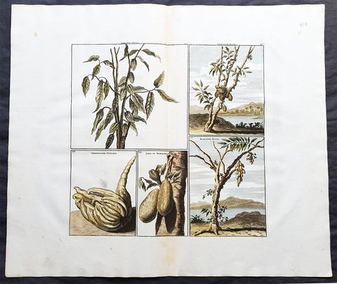
1698 De Bruyn Antique Print of Cacao, Chinese lemon, Jaka Plants of Indonesia
- Title : Kakauw vrugt, Chineesche Citroen, Jaka or Soorsacke, Blim-Bing boom and Nam-Nam boom
- Date : 1698
- Condition: (A+) Fine Condition
- Ref: 23405
- Size: 18 1/2in x 16in (470mm x 405mm)
Description:
This beautifully hand coloured original antique print of Cacao fruit, Chinese lemon, Jaka or Soorsacke, Nam-Nam tree and a Blim-bing tree from Indonesia was published as part of Cornelis de Bruyn`s (1652 c.1726) monumental travel publication Reizen Door Klien Asia, 1698.
De Bruyn was a Dutch portrait painter and traveler. He painted for some years in Italy, where he was known, in Rome, as Adonis. Bruyn is remembered chiefly for the records of his extensive travels in Egypt, Persia, India, and other countries, illustrated with his own designs. (Ref: M&B, Tooley)
General Description:
Paper thickness and quality: - Heavy & stable
Paper color: - White Age of map color: - Early
Colors used: - Blue, yellow, green, red
General color appearance: - Authentic
Paper size: - 18 1/2in x 16in (470mm x 405mm)
Plate size: - 11 1/2in x 11 1/2in (290mm x 290mm)
Margins: - Min 2in (50mm)
Imperfections:
Margins: - None
Plate area: - None
Verso: - None
1819 Gainsborough & Wells Antique Print of an English Country Farming Scene
- Title : From the Original in the Collection of the Rt. Hon. ble Baroness Lucas...T Gainsborough del. W.F. Wells sculpt.
- Date : 1801
- Condition: (A+) Fine Condition
- Ref: 91222
- Size: 17 1/4in x 11 1/2in (440mm x 290mm)
Description:
This large beautiful executed original antique soft ground etched print with hand tint colour, of a English country scene after Thomas Gainsborough, was engraved by William Frederick Wells and published in A Collection of Prints Illustrative of English Scenery From the Drawings and Sketches of Thos. Gainsborough, R.A. in the various collections of The Baroness Lucas; Viscount Palmerston; George Herbert, Esq.; Dr. Monro by John and Josiah Boydell, London in 1819.
The English painter Thomas Gainsborough (1727-1788) ranks as one of the principal masters and innovators of the English school of landscape painting. Thomas Gainsborough was baptized in Sudbury, Suffolk, on May 14, 1727. His father, a substantial cloth merchant, recognized Thomas's precocious artistic gifts and sent him at an early age, possibly 12, to London. Gainsborough was connected with the artists Francis Hayman and Hubert François Gravelot, possibly as apprentice to the former and assistant to the latter. Gainsborough is reported to have copied and restored Dutch landscapes for dealers. At the age of 19 he married Margaret Burr, reputedly a natural daughter of the Duke of Beaufort, who is said to have brought him an income of £200 a year.
At the age of 21 Gainsborough was so much admired as a landscape painter that he was invited with the leading artists of the day to present a picture to the Foundling Hospital in London. His painting, The Charterhouse, shows a mature observation of reality and handling of light. From Hayman the scene painter and Gravelot the rococo decorator Gainsborough learned to approach pictorial composition on inventive principles, and the alternation between observation and invention henceforth became the basis of his artistic growth. The two approaches may be illustrated by comparing Mr. and Mrs. Robert Andrews (ca. 1749), with a deliciously observed Suffolk landscape dappled by sunlight and shadow of cloud, and Henéage Lloyd and His Sister (ca. 1750), shown against a limpid background of stage scenery.
Gainsborough's art after his early London studies falls into three main divisions: the Suffolk period, 1748-1759; the Bath period, 1759-1774; and the years of fame in London, 1774-1788. In Suffolk he combined the charms of the modern conversation piece with those of realistic landscape, thus making a strong appeal to the country gentry. Here too he painted the Suffolk countryside as faithfully and freshly as if he were a Dutch painter reborn in the 18th century.
William Frederick Wells (1762 - 10 Nov 1836) was an English watercolour landscape painter and etcher. Wells was born in London in 1762. Wells studied art in London under John James Barralet (1747–1815). On 20 November 1804, Wells initiated the founding of the Society of Painters in Watercolours (now the Royal Watercolour Society), at a meeting held at the Stratford Coffee House, Oxford St, London. He served as President of the fledgling association from 1806 to 1807.
He travelled and painted extensively in England and Europe, particularly in Norway and Sweden. Wells' art was annually exhibited at the Royal Academy from 1795 to 1813. He held the post of Professor of Drawing at Addiscombe Military Seminary for officers of the East India Company Army over twenty years from 1813 until his retirement, immediately before his death, in November 1836.[1] Wells was an intimate friend of Joseph Mallord William Turner. Among his works as an etcher are two fine sets in soft ground; Thomas Gainsborough's English Scenery (1819) and Select Views in Cumberland (1810).
General Description:
Paper thickness and quality: - Heavy and stable
Paper color: - off white
Age of map color: - Original
Colors used: - Blue, orange, green, brown
General color appearance: - Authentic
Paper size: - 17 1/4in x 11 1/2in (440mm x 290mm)
Plate size: - 12 1/2in x 9 1/2in (315mm x 245mm)
Margins: - Min 2in (50mm)
Imperfections:
Margins: - None
Plate area: - None
Verso: - None
1757 Abraham Swan Large Antique Print of 18th century Architect Design
- Title : Ab. Swan Archt. Published aaccording to Act July 1757. Thomas Miller Sculpt.
- Date : 1757
- Condition: (A+) Fine Condition
- Ref: 70538
- Size: 15 1/2in x 10in (395mm x 255mm)
Description:
This fine original antique print of two interior architectural designs by the 18th century architect Abraham Swan was engraved by Thomas Miller in 1757 - the date is engraved at the foot of the print - and was published in Swans A collection of designs in architecture : containing new plans and elevations of houses, for general use. 1757(Ref: M&B; Tooley)
General Description:
Paper thickness and quality: - Heavy & stable
Paper color: - White
Age of map color: -
Colors used: -
General color appearance: -
Paper size: - 15 1/2in x 10in (395mm x 255mm)
Plate size: - 14in x 8in (355mm x 205mm)
Margins: - Min 1/2in (12mm)
Imperfections:
Margins: - None
Plate area: - None
Verso: - None
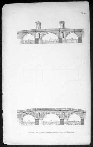
1757 Abraham Swan Antique Architect Print of Ornate 18th century Bridges
- Title : Ab. Swan Archt. Published aaccording to Act Nov 14th 1757. In. Addison Sculpt.
- Date : 1757
- Condition: (A) Very Good Condition
- Ref: 70539
- Size: 15 1/2in x 10in (395mm x 255mm)
Description:
This fine original antique print of two interior architectural designs by the 18th century architect Abraham Swan was engraved by Thomas Miller in 1757 - the date is engraved at the foot of the print - and was published in Swans A collection of designs in architecture : containing new plans and elevations of houses, for general use. 1757(Ref: M&B; Tooley)
General Description:
Paper thickness and quality: - Heavy & stable
Paper color: - White
Age of map color: -
Colors used: -
General color appearance: -
Paper size: - 15 1/2in x 10in (395mm x 255mm)
Plate size: - 14in x 8in (355mm x 205mm)
Margins: - Min 1/2in (12mm)
Imperfections:
Margins: - None
Plate area: - None
Verso: - None
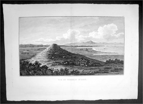
1802 J B Lechevalier Antique Print View of Tomb of Ajax Troy in Troad, NW Turkey
- Title : Vue Du Tombeau D'Ajax
- Date : 1802
- Condition: (A+) Fine Condition
- Ref: 70224
- Size: 19 1/4in x 14in (495mm x 355mm)
Description:
This original copper-plate engraved antique print view of the Tomb of Ajax the Great near in the ancient Greek city of Troy in the Troad region of NW Turkey was published in the 1802 edition of Jean-Baptiste Lechevaliers of Voyage de la Troade, fait dans les années 1785 et 1786
General Definitions:
Paper thickness and quality: - Heavy and stable
Paper color : - off white
Age of map color: -
Colors used: -
General color appearance: -
Paper size: - 20in x 14in (510mm x 360mm)
Plate size: - 17 1/2in x 11in (445mm x 280mm)
Margins: - Min 1/2in (12mm)
Imperfections:
Margins: - None
Plate area: - Light toning along centerfold
Verso: - None
Background:
Ajax or Aiasis a Greek hero, the son of King Telamon and Periboea, and the half-brother of Teucer. He plays an important role, and is portrayed as a towering figure and a warrior of great courage in Homers Iliad and in the Epic Cycle, a series of epic poems about the Trojan War. He is also referred to as Telamonian Ajax (Αἴας ὁ Τελαμώνιος, in Etruscan recorded as Aivas Tlamunus), Greater Ajax, or Ajax the Great, which distinguishes him from Ajax, son of Oileus (Ajax the Lesser).
Jean-Baptiste Lechevalier was the secretary of the Ambassador of France in Constantinople. In the year 1788 he visited the plain of Troy, and was enthusiastically in favour of the theory that the site of Homers Troy was to be found at the village of Bunarbashi. His publication about Troy Voyage de la Troade.....was first published in 1799.
The Troad, also known as Troas, is the historical name of the Biga peninsula (Biga Yarımadası, Τρωάς) in the northwestern part of Anatolia, Turkey. This region now is part of the Çanakkale province of Turkey. Bounded by the Dardanelles to the northwest, by the Aegean Sea to the west and separated from the rest of Anatolia by the massif that forms Mount Ida, the Troad is drained by two main rivers, the Scamander (Karamenderes) and the Simois, which join at the area containing the ruins of Troy. Grenikos, Kebren, Simoeis, Rhesos, Rhodios, Heptaporos and Aisepos were seven rivers of the Troad and the names of the river gods that inhabited each river.
Troy (Ancient Greek: Τροία, Troia or Τροίας, Troias, Truva or Troya) was a city in the far northwest of the region known in late Classical antiquity as Asia Minor, now known as Anatolia in modern Turkey, just south of the southwest mouth of the Dardanelles strait and northwest of Mount Ida. The present-day location is known as Hisarlik. It was the setting of the Trojan War described in the Greek Epic Cycle, in particular in the Iliad, one of the two epic poems attributed to Homer. Metrical evidence from the Iliad and the Odyssey suggests that the name λιον (Ilion) formerly began with a digamma: Ϝίλιον (Wilion); this is also supported by the Hittite name for what is thought to be the same city, Wilusa.
A new capital called Ilium (from Greek: λιον, Ilion) was founded on the site in the reign of the Roman Emperor Augustus. It flourished until the establishment of Constantinople, became a bishopric and declined gradually in the Byzantine era, but is now a Latin Catholic titular see.
In 1865, English archaeologist Frank Calvert excavated trial trenches in a field he had bought from a local farmer at Hisarlik, and in 1868, Heinrich Schliemann, a wealthy German businessman and archaeologist, also began excavating in the area after a chance meeting with Calvert in Çanakkale. These excavations revealed several cities built in succession. Schliemann was at first skeptical about the identification of Hisarlik with Troy, but was persuaded by Calvert and took over Calverts excavations on the eastern half of the Hisarlik site, which was on Calvert\'s property. Troy VII has been identified with the city called Wilusa by the Hittites (the probable origin of the Greek λιον) and is generally (but not conclusively) identified with Homeric Troy.
Today, the hill at Hisarlik has given its name to a small village near the ruins, which supports the tourist trade visiting the Troia archaeological site. It lies within the province of Çanakkale, some 30 km south-west of the provincial capital, also called Çanakkale. The nearest village is Tevfikiye. The map here shows the adapted Scamander estuary with Ilium a little way inland across the Homeric plain. Due to Troys location near the Aegean Sea, the Sea of Marmara, and the Black Sea, it was a central hub for the military and trade(Ref: M&B; Tooley)