On Sale (6)
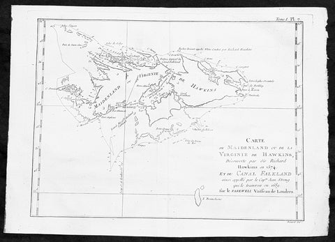
1747 Bellin Antique Map of the Falkland or Maldives Islands Argentina South America
- Title: Carte de Maidenland ou de la Virginie de Hawkins...Richard Hawkins 1574...Cap Jean Strong...1689
- Date: 1747
- Condition : (A+) Fine Condition
- Ref: 35488
- Size: 14in x 10in (360mm x 255mm)
Description:
This fine, original copper-plate engraved antique map of the Falkland Islands by Jacques Nicolas Bellin in 1750 was published in Antoine François Prevosts 15 volumes of Histoire Generale des Voyages written by Prevost & other authors between 1746-1790.
Although Fuegians from Patagonia may have visited the Falkland Islands in prehistoric times, the islands were uninhabited at the time of their discovery by Europeans. Claims of discovery date back to the 16th century, but no consensus exists on whether early explorers discovered the Falklands or other islands in the South Atlantic. The first recorded landing on the islands is attributed to English captain John Strong, who, en route to Peru\'s and Chile\'s littoral in 1690, discovered the Falkland Sound and noted the islands\' water and game.
The Falklands remained uninhabited until the 1764 establishment of Port Louis on East Falkland by French captain Louis Antoine de Bougainville, and the 1766 foundation of Port Egmont on Saunders Island by British captain John MacBride. Whether or not the settlements were aware of each other\'s existence is debated by historians. In 1766, France surrendered its claim on the Falklands to Spain, which renamed the French colony Puerto Soledad the following year. Problems began when Spain discovered and captured Port Egmont in 1770. War was narrowly avoided by its restitution to Britain in 1771.
Both the British and Spanish settlements coexisted in the archipelago until 1774, when Britain\'s new economic and strategic considerations led it to voluntarily withdraw from the islands, leaving a plaque claiming the Falklands for King George III. Spain\'s Viceroyalty of the Río de la Plata became the only governmental presence in the territory. West Falkland was left abandoned, and Puerto Soledad became mostly a prison camp.Amid the British invasions of the Río de la Plata during the Napoleonic Wars in Europe, the islands\' governor evacuated the archipelago in 1806; Spain\'s remaining colonial garrison followed suit in 1811, except for gauchos and fishermen who remained voluntarily.
General Definitions:
Paper thickness and quality: - Heavy and stable
Paper color : - off white
Age of map color: -
Colors used: -
General color appearance: -
Paper size: - 14in x 10in (355mm x 255mm)
Plate size: - 12in x 8in (305mm x 205mm)
Margins: - Min 1/2in (12mm)
Imperfections:
Margins: - None
Plate area: - None
Verso: - None
Background:
One of Antoine Francois Prevosts monumental undertakings was his history of exploration & discovery in 15 volumes titledHistoire Générale des Voyages written between 1746-1759 and was extended to 20 volumes after his death by various authors.
The 20 volumes cover the early explorations & discoveries on 3 continents: Africa (v. 1-5), Asia (v. 5-11), and America (v. 12-15) with material on the finding of the French, English, Dutch, and Portugese.
A number of notable cartographers and engravers contributed to the copper plate maps and views to the 20 volumes including Nicolas Bellin, Jan Schley, Chedel, Franc Aveline, Fessard, and many others.
The African volumes cover primarily coastal countries of West, Southern, and Eastern Africa, plus the Congo, Madagascar, Arabia and the Persian Gulf areas.
The Asian volumes cover China, Korea, Tibet, Japan, Philippines, and countries bordering the Indian Ocean.
Volume 11 includes Australia and Antarctica.
Volumes 12-15 cover voyages and discoveries in America, including the East Indies, South, Central and North America.
Volumes 16-20 include supplement volumes & tables along with continuation of voyages and discoveries in Russia, Northern Europe, America, Asia & Australia.
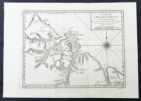
1753 Bellin Antique Map of The Island of Cayenne French Guyana, South America
- Title: Carte de L Isle De Caienne et de ses Environs...1753
- Date: 1753
- Condition : (A+) Fine Condition
- Ref: 92015
- Size: 15in x 11in (390mm x 275mm)
Description:
This fine, original copper-plate engraved antique map of the City Island of Cayenne in French Guyana, South America by Jacques Nicolas Bellin was engraved in 1753 - dated - and was published in Antoine François Prevosts 15 volumes of Histoire Generale des Voyages written by Prevost & other authors between 1746-1790.
Cayenne is the capital city of French Guiana, an overseas region and department of France located in South America. The city stands on a former island at the mouth of the Cayenne River on the Atlantic coast. The city\'s motto is fert aurum industria, which means \"work brings wealth.
Ignored by Spanish explorers, who found the region too hot and poor to be claimed, the region was not colonized until 1604, when a French settlement was founded. However, it was soon destroyed by the Portuguese, who were determined to enforce the provisions of the Treaty of Tordesillas. French colonists returned in 1643 and founded Cayenne, but they were forced to leave once more following Amerindian attacks. In 1664, France finally succeeded at establishing a permanent settlement at Cayenne. Over the next decade the colony changed hands between the French, Dutch, and English, before being restored to France. It was captured by an Anglo-Portuguese force at the invasion of Cayenne in 1809 and administered from Brazil until 1814, when it was returned to French control. It was used as a French penal colony from 1854 to 1938.
General Definitions:
Paper thickness and quality: - Heavy and stable
Paper color : - off white
Age of map color: -
Colors used: -
General color appearance: -
Paper size: - 13in x 10in (330mm x 255mm)
Plate size: - 12in x 9in (305mm x 230mm)
Margins: - Min 1/2in (12mm)
Imperfections:
Margins: - None
Plate area: - None
Verso: - None
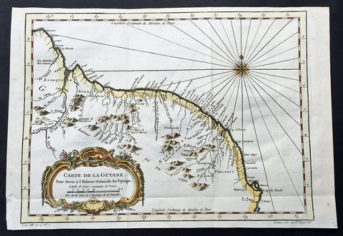
1757 Bellin Large Antique Map of Guyana, South America
- Title: Carte de la Guyana...1757
- Date: 1757
- Condition : (A+) Fine Condition
- Ref: 60940
- Size: 15in x 10in (380mm x 255mm)
Description:
This fine, original copper-plate engraved antique map of Guyana, South America by Jacques Nicolas Bellin was engraved in 1757 - dated - and was published in Antoine François Prevosts 15 volumes of Histoire Generale des Voyages written by Prevost & other authors between 1746-1790.
Guyana officially the Co-operative Republic of Guyana, is a sovereign state on the northern mainland of South America. It is, however, often considered part of the Caribbean region because of its strong cultural, historical, and political ties with other Anglo Caribbean countries and the Caribbean Community (CARICOM). Guyana is bordered by the Atlantic Ocean to the north, Brazil to the south and southwest, Suriname to the east and Venezuela to the west.
There are nine indigenous tribes residing in Guyana: the Wai Wai, Macushi, Patamona, Lokono, Kalina, Wapishana, Pemon, Akawaio and Warao. Historically the Lokono and Kalina tribes dominated Guyana. Although Christopher Columbus sighted Guyana during his third voyage (in 1498), and Sir Walter Raleigh wrote an account of its discovery in 1596, the Dutch were the first to establish colonies: Essequibo (1616), Berbice (1627), and Demerara (1752). After the British assumed control in 1796, the Dutch formally ceded the area in 1814. In 1831 the three separate colonies became a single British colony known as British Guiana.
General Definitions:
Paper thickness and quality: - Heavy and stable
Paper color : - off white
Age of map color: - Early
Colors used: - Green, yellow, orange
General color appearance: - Authentic
Paper size: - 15in x 10in (380mm x 255mm)
Plate size: - 13in x 9 1/2in (330mm x 245mm)
Margins: - Min 1/2in (12mm)
Imperfections:
Margins: - None
Plate area: - Folds as issued
Verso: - None
One of Antoine Francois Prevosts monumental undertakings was his history of exploration & discovery in 15 volumes titledHistoire Générale des Voyages written between 1746-1759 and was extended to 20 volumes after his death by various authors.
The 20 volumes cover the early explorations & discoveries on 3 continents: Africa (v. 1-5), Asia (v. 5-11), and America (v. 12-15) with material on the finding of the French, English, Dutch, and Portugese.
A number of notable cartographers and engravers contributed to the copper plate maps and views to the 20 volumes including Nicolas Bellin, Jan Schley, Chedel, Franc Aveline, Fessard, and many others.
The African volumes cover primarily coastal countries of West, Southern, and Eastern Africa, plus the Congo, Madagascar, Arabia and the Persian Gulf areas.
The Asian volumes cover China, Korea, Tibet, Japan, Philippines, and countries bordering the Indian Ocean.
Volume 11 includes Australia and Antarctica.
Volumes 12-15 cover voyages and discoveries in America, including the East Indies, South, Central and North America.
Volumes 16-20 include supplement volumes & tables along with continuation of voyages and discoveries in Russia, Northern Europe, America, Asia & Australia.
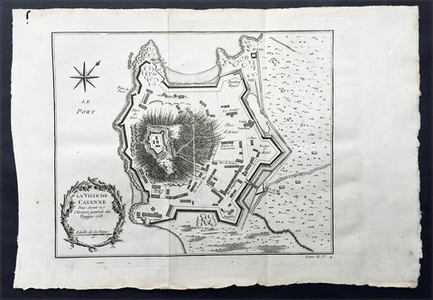
1753 Bellin Antique Map Plan of the City of Cayenne French Guyana, South America
- Title: La Ville De Cayenne...1753
- Date: 1753
- Condition : (A+) Fine Condition
- Ref: 92016
- Size: 15in x 11in (390mm x 275mm)
Description:
This beautifully engraved original antique map a plan of the city of Cayenne capital of French Guyana, South America was engraved by Jacques Nicolas Bellin in 1753 - the date is engraved in the title cartouche - and was published by Jacques Nicolas Bellin for Antoine-François Prevosts 20 volume edition of L`Histoire Generale des Voyages published by Pierre de Hondt, The Hague in 1747. (Ref: Tooley; M&B)
General Description:
Paper thickness and quality: - Heavy and stable
Paper color: - white
Age of map color: -
Colors used: -
General color appearance: -
Paper size: - 15in x 11in (390mm x 275mm)
Plate size: - 11 1/2in x 9 1/2in (290mm x 245mm)
Margins: - min. 1in (25mm)
Imperfections:
Margins: - None
Plate area: - Folds as issued
Verso: - None
Condition : (A+) Fine Condition
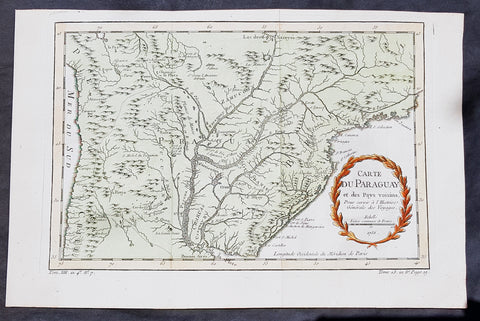
1756 Bellin Antique Map of Paraguay & Brazil, South America
- Title: Carte Du Paraguay...1756
-
Date: 1756
Condition : (A+) Fine Condition - Ref: 60939
- Size: 15in x 10in (380mm x 255mm)
Description:
This fine, original copper-plate engraved antique map of Paraguay South America, by Jacques Nicolas Bellin in 1756 was published in Antoine François Prevosts 15 volumes of Histoire Generale des Voyages written by Prevost & other authors between 1746-1790.
The first Europeansto explore the country were Spanish explorers in 1516. The Spanish explorer Juan de Salazar de Espinosa founded the settlement of Asunción on 15 August 1537. The city eventually became the center of a Spanish colonial province of Paraguay.
An attempt to create an autonomous Christian Indian nation was undertaken by Jesuit missions and settlements in this part of South America in the eighteenth century, which included portions of Uruguay, Argentina, and Brazil. They developed Jesuit reductions to bring Guarani populations together at Spanish missions and protect them from virtual slavery by Spanish settlers and Portuguese slave raiders, the Bandeirantes. In addition to seeking their conversion to Christianity. Catholicism in Paraguay was influenced by the indigenous peoples; the syncretic religion has absorbed native elements. The reducciones flourished in eastern Paraguay for about 150 years, until the expulsion of the Jesuits by the Spanish Crown in 1767. The ruins of two 18th-century Jesuit Missions of La Santísima Trinidad de Paraná and Jesús de Tavarangue have been designated as World Heritage Sites by UNESCO.
In western Paraguay Spanish settlement and Christianity were strongly resisted by the nomadic Guaycuru and other nomads from the 16th century onward. Most of these peoples were absorbed into the mestizo population in the 18th and 19th centuries.
General Definitions:
Paper thickness and quality: - Heavy and stable
Paper color : - off white
Age of map color: - Early
Colors used: - Yellow, green, red
General color appearance: - Authentic
Paper size: - 15in x 10in (380mm x 255mm)
Plate size: - 13in x 8 1/2in (330mm x 215mm)
Margins: - Min 1/2in (12mm)
Imperfections:
Margins: - None
Plate area: - Folds as issued
Verso: - None
Background:
One of Antoine Francois Prevosts monumental undertakings was his history of exploration & discovery in 15 volumes titledHistoire Générale des Voyages written between 1746-1759 and was extended to 20 volumes after his death by various authors.
The 20 volumes cover the early explorations & discoveries on 3 continents: Africa (v. 1-5), Asia (v. 5-11), and America (v. 12-15) with material on the finding of the French, English, Dutch, and Portugese.
A number of notable cartographers and engravers contributed to the copper plate maps and views to the 20 volumes including Nicolas Bellin, Jan Schley, Chedel, Franc Aveline, Fessard, and many others.
The African volumes cover primarily coastal countries of West, Southern, and Eastern Africa, plus the Congo, Madagascar, Arabia and the Persian Gulf areas.
The Asian volumes cover China, Korea, Tibet, Japan, Philippines, and countries bordering the Indian Ocean.
Volume 11 includes Australia and Antarctica.
Volumes 12-15 cover voyages and discoveries in America, including the East Indies, South, Central and North America.
Volumes 16-20 include supplement volumes & tables along with continuation of voyages and discoveries in Russia, Northern Europe, America, Asia & Australia.
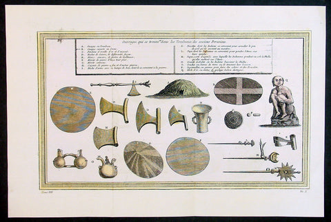
1755 Prevost & Schley Antique Print of Artifacts Recovered from Inca Burial Tomb
- Title: Puvrages qui se trouvent dans les Tombeaux des anciens Peruviens
- Date: 1755
- Condition : (A+) Fine Condition
- Ref: 34132
- Size: 15in x 10in (385mm x 255mm)
Description:
This fine, original copper-plate engraved antique print of artifacts found in an Inca Tomb in Peru by Jakob van Schley in 1755 - after De Bry - was published in Antoine François Prevosts 15 volumes of Histoire Generale des Voyages written by Prevost & other authors between 1746-1790.
The Inca Empire also known as the Incan Empire and the Inka Empire, was the largest empire in pre-Columbian America, and possibly the largest empire in the world in the early 16th century. Its political and administrative structure \"was the most sophisticated found among native peoples\" in the Americas.The administrative, political and military center of the empire was located in Cusco in modern-day Peru. The Inca civilization arose from the highlands of Peru sometime in the early 13th century. Its last stronghold was conquered by the Spanish in 1572.
From 1438 to 1533, the Incas incorporated a large portion of western South America, centered on the Andean Mountains, using conquest and peaceful assimilation, among other methods. At its largest, the empire joined Peru, large parts of modern Ecuador, western and south central Bolivia, northwest Argentina, north and central Chile and a small part of southwest Colombia into a state comparable to the historical empires of Eurasia. Its official language was Quechua.Many local forms of worship persisted in the empire, most of them concerning local sacred Huacas, but the Inca leadership encouraged the worship of Inti – their sun god – and imposed its sovereignty above other cults such as that of Pachamama. The Incas considered their king, the Sapa Inca, to be the \"son of the sun.\"
The Inca Empire was unique in that it lacked many features associated with civilization in the Old World. In the words of one scholar, \"The Incas lacked the use of wheeled vehicles. They lacked animals to ride and draft animals that could pull wagons and plows... [They] lacked the knowledge of iron and steel... Above all, they lacked a system of writing... Despite these supposed handicaps, the Incas were still able to construct one of the greatest imperial states in human history\". Notable features of the Inca Empire include its monumental architecture, especially stonework, extensive road network reaching all corners of the empire, finely-woven textiles, use of knotted strings (quipu) for record keeping and communication, agricultural innovations in a difficult environment, and the organization and management fostered or imposed on its people and their labor.
The Incan economy has been described in contradictory ways by scholars: as \"feudal, slave, socialist (here one may choose between socialist paradise or socialist tyranny)\". The Inca empire functioned largely without money and without markets. Instead, exchange of goods and services was based on reciprocity between individuals and among individuals, groups, and Inca rulers. \"Taxes\" consisted of a labor obligation of a person to the Empire. The Inca rulers (who theoretically owned all the means of production) reciprocated by granting access to land and goods and providing food and drink in celebratory feasts for their subjects.
General Definitions:
Paper thickness and quality: - Heavy and stable
Paper color : - off white
Age of map color: - Early
Colors used: - Yellow, green, red
General color appearance: - Authentic
Paper size: - 15in x 10in (385mm x 255mm)
Plate size: - 14in x 8 1/2in (355mm x 220mm)
Margins: - Min 1in (25mm)
Imperfections:
Margins: - None
Plate area: - Folds as issued
Verso: - None
Background:
One of Antoine Francois Prevosts monumental undertakings was his history of exploration & discovery in 15 volumes titledHistoire Générale des Voyages written between 1746-1759 and was extended to 20 volumes after his death by various authors.
The 20 volumes cover the early explorations & discoveries on 3 continents: Africa (v. 1-5), Asia (v. 5-11), and America (v. 12-15) with material on the finding of the French, English, Dutch, and Portugese.
A number of notable cartographers and engravers contributed to the copper plate maps and views to the 20 volumes including Nicolas Bellin, Jan Schley, Chedel, Franc Aveline, Fessard, and many others.
The African volumes cover primarily coastal countries of West, Southern, and Eastern Africa, plus the Congo, Madagascar, Arabia and the Persian Gulf areas.
The Asian volumes cover China, Korea, Tibet, Japan, Philippines, and countries bordering the Indian Ocean.
Volume 11 includes Australia and Antarctica.
Volumes 12-15 cover voyages and discoveries in America, including the East Indies, South, Central and North America.
Volumes 16-20 include supplement volumes & tables along with continuation of voyages and discoveries in Russia, Northern Europe, America, Asia & Australia.
Jakob van der Schley aka Jakob van Schley (1715 - 1779) was a Dutch draughtsman and engraver. He studied under Bernard Picart (1673-1733) whose style he subsequently copied. His main interests were engraving portraits and producing illustrations for \\\"La Vie de Marianne\\\" by Pierre Carlet de Chamblain de Marivaux (1688-1763) published in The Hague between 1735 and 1747.
He also engraved the frontispieces for a 15-volume edition of the complete works of Pierre de Brantôme (1540-1614), \\\"Oeuvres du seigneur de Brantôme\\\", published in The Hague in 1740.
He is also responsible for most of the plates in the Hague edition of Prévosts Histoire générale des voyages. (Ref: Tooley; M&B)