Welcome to Classical Images!
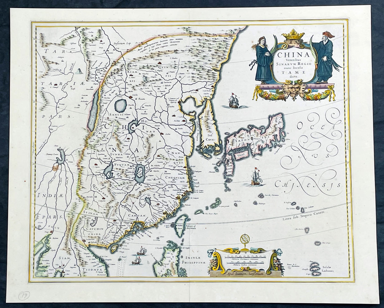
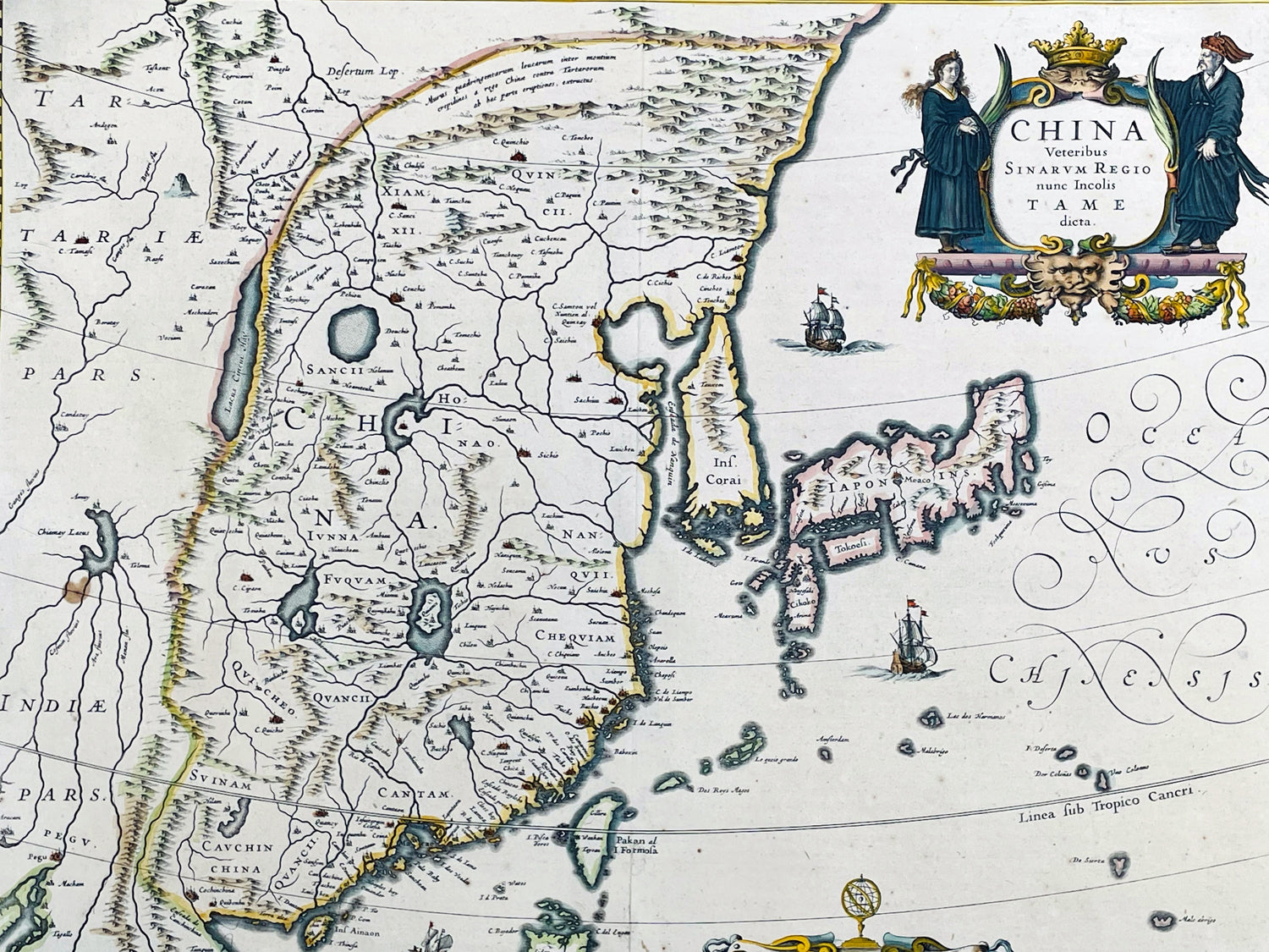
Description:This incredibly important, original hand coloured copper plate engraved antique map of China by Jan Jansson was published in the 1646 French edition of Janssonius Atlas NouvsThis antique map Jansson is a stunning example of 17th-century cartography. The map depicts China, Taiwan, and parts of Korea and Japan in intricate detail, with mountains, rivers, and cities clearly labeled and illustrated. The map is adorned with decorative elements, including a detailed cartouche featuring a Chinese dragon and two figures in traditional dress. The title of the map, translated as "China, formerly known as Sina, now inhabited by the Tame," highlights the historical significance of the region and its changing cultural identity over time. Overall, this map is a beautiful and informative representation of China during a pivotal period in its history.
General Definitions:Paper thickness and quality: - Heavy and stablePaper color : - off whiteAge of map color: - OriginalColors used: - Yellow, green, blue, pinkGeneral color appearance: - AuthenticPaper size: - 22 1/2in x 18in (570mm x 455mm)Plate size: - 20in x 16 1/2in (508mm x 415mm)Margins: - Min 1/2in (12mm)
Imperfections:Margins: - NonePlate area: - NoneVerso: - Bottom centerfold re-joined, not affecting the image
Background:This antique map of China, Japan & Korea was created by Johannes Janssonius (Jansson), a prominent Dutch cartographer of the 17th century. The map was published in Amsterdam in the mid 17th century and is considered one of the most important early maps of China.The map shows China as it was known at the time, including its various provinces, rivers, and mountain ranges. It also depicts neighboring regions such as Korea, Japan, and parts of Southeast Asia. The map is rich in detail and includes various cities and towns, as well as important landmarks such as the Great Wall of China.Jansson based his map on earlier maps of China, including those produced by the Jesuit missionary Matteo Ricci and the Dutch explorer Jan Huygen van Linschoten. However, Jansson added his own cartographic touches, such as more precise depictions of the rivers and mountain ranges.The map's title, China Veteribus Sinarum Regio nune Incolis Tame dicta, translates to China, the ancient land of the Sinae, now known to its inhabitants as Tame. The term Sinae was a term used by ancient Greek and Roman geographers to refer to the Chinese people, while Tame was the name used by the Chinese themselves to refer to their country.This Map was highly prized by collectors and scholars in Europe during the 17th century. It remains a valuable resource for historians, geographers, and anyone interested in the history of China and cartography.
Jansson, Jan (Janssonius) 1588-1664Johannes Janssonius, more commonly known to us as Jan Jansson, was a Dutch cartographer and publisher who made significant contributions to the field of cartography during the 17th century.Born in Arnhem, Netherlands, Janssonius was the son of a bookseller and publisher, who introduced him to the world of publishing and cartography. After studying in Amsterdam, Janssonius took over his father's business and began to publish maps and atlases, many of which were based on the work of famous cartographers like Gerard Mercator.In 1621, Janssonius formed a partnership with his brother-in-law, Henricus Hondius, and together they published atlases, maps, and globes under the name "Hondius-Janssonius". This partnership lasted until Hondius' death in 1651, after which Janssonius continued to publish under his own name.Janssonius' maps and atlases were highly regarded for their accuracy and detail, and his work was widely distributed throughout Europe. His maps covered a wide range of regions, including Europe, Asia, Africa, and the Americas.Janssonius also contributed to the development of the engraving and printing techniques used in cartography, which allowed for more precise and detailed maps to be produced.Jan Janssonius died in Amsterdam in 1664, but his legacy lived on through his maps and atlases, which remained popular among cartographers and collectors for centuries to come. Today, Janssonius is remembered as one of the most important cartographers of the 17th century, and his work continues to be studied and admired by scholars and enthusiasts around the world.Please note all items auctioned are genuine, we do not sell reproductions. A Certificate of Authenticity (COA) can be issued on request.