Products
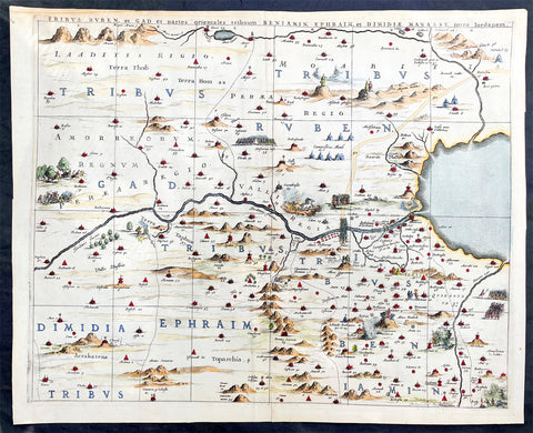
1662 Hornius & Jansson Antique Holy Land Map Tribes Ruben, Gad, Benjamin, Ephraim & Manasseh
Antique Map
- Title : Tribus Ruben, et Gad parties orientales tribumum Beniamin, Ephraim, et Dimidiae, Manasse, intra Jordanem
- Ref #: 17016
- Size: 23in x 18 1/2in (580mm x 470mm)
- Date : 1662
- Condition: (A+) Fine Condition
Description:
This large, important & scarce hand coloured original copper-plate engraved antique map, one of six, of the Tribes of Ruben, Gad, Benjamin, Ephraim & Manasseh located to the north and east of the Dead Sea was published by Jan Jansson & Georguis Hornius (1620-1670) in the 1662 French Edition of Atlas Major, based on the 1590 map of Christian van Adricham, Situs Terrae Promissionis.
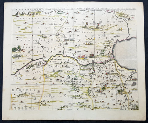
This map is #1 of 6 published by Jansson that combined measures 66in long by 37in wide (1.68m x 940mm) Please see the B&W image to see combined maps.
Tribus Ruben, et Gad et partes orientales tribuum Beniamin, Ephraim, et dimidiae Manasse intra Iordenem. This is usually thought to the be the first panel in the series. It includes several vignettes, such as Jesus and Satan arguing on a mountaintop, Moses looking across the Jordan, the entry point of the Hebrews into the land of Milk and Honey, and a stairway ascending to heaven. This panel shows the lands controlled by Ruben and Gad, as well as the eastern lands of Benjamin, Ephraim, and part of Manasseh beyond the Jordan River. It also shows the western part of the Dead Sea.
General Definitions:
Paper thickness and quality: - Heavy and stable
Paper color : - off white
Age of map color: - Original
Colors used: - Yellow, green, blue, pink
General color appearance: - Authentic
Paper size: - 23in x 18 1/2in (580mm x 470mm)
Plate size: - 22in x 17 1/2in (560mm x 445mm)
Margins: - Min 1in (25mm)
Imperfections:
Margins: - Light age toning
Plate area: - None
Verso: - None
Background:
Jan Jansson based his map on Christian van Adrichams Situs Terrae Promissionis of ca. 1590. This version is both expanded and carries additional vignettes and details. Georgius Hornius wrote the text that accompanied the map in volume six of Janssons Novus Atlas, Accuratissimia Orbis Antiqui Delineatio.
The map shows the region divided into domains of the Twelve Tribes of Israel on both sides of the Jordan River, with the shoreline running from Sidon to Alexandria. The Cison Torrens (Kishon River) is shown as connecting the Sea of Galilee with the Mediterranean Sea, and there are many rivers, some of which do not exist; for example, there is a river connecting Jerusalem with the Dead Sea. In the Dead Sea, four burning cities are shown: Sodom, Gomorra, Seboim, and Adama.
The map is intricately engraved to show topographical features, major roads, towns and villages. It is also richly embellished with dozens of biblical illustrations. Inset maps in the top corners depict Abrahams journey (left) and the wandering of the Israelites through the desert (right).
Maps of the Holy Land, a popular genre in the early modern period, allowed users to better understand events from religious traditions. For the mapmaker, the relationship between religion and geography acted as a powerful storytelling tool, allowing viewers to spatialize religious stories. The maps show the centrality of religion to early modern European culture, as well as an enduring interest in historical geography.
According to the Hebrew Bible, the Twelve Tribes of Israel, shown here, descended from the twelve sons of Jacob. According to Deuteronomy, the twelve sons were Reuben, Simeon, Judah, Issachar, Zebulun, Benjamin, Dan, Naphtali, Gad, Asher, Ephraim, and Manasseh..
In the tenth century BCE, the Israelites made up of about 300 highland villages with a population of approximately 40,000 people. These villages would begin to conglomerate in the ninth century BCE. The kingdom formed by their joining was referred to by its neighbors as the House of David. After the kingdoms of Samaria and Judah were destroyed, the resulting Babylonian captivity caused a merging of the south Levantine groups into a unified cultural identity.
This unified kingdom would ultimately not last, however. Tensions between the tribes of Israel mounted over a disagreement as to the location of the mountain on which Moses attempted to sacrifice Isaac. Eventually, the tensions exploded when the Hasmonean King destroyed the temple of another tribe, which caused the lower Levant to devolve into chaos. This civil conflict would last until the Roman Empire invaded, with future emperor Vespasian leading an army into Israel under the pretense of restoring order. This resulted in Roman dominance over the lower Levant until the Muslim conquests of the seventh century CE.
Although published by Jan Jansson, the map was made in collaboration with Georgius Hornius (1620-1670). Indeed, it is often called the Hornius Map. Hornius was a renowned cartographer and historian who published maps as well. His family was forced to flee to Nuremberg during the religious violence of the Thirty Years War. He would eventually attend the University of Altdorf, studying religion and medicine there.
Horniuss first notable work was a history of the English Civil War, which he witnessed firsthand as a traveler. In 1648 he completed his doctorate in Leiden; by this time, his historical works had drawn the attention of many universities which sought him as a professor. He eventually decided to accept a professorship at the University of Harderwijk where he quickly became rector in 1652, a position he would hold until his death in 1670.
Horniuss historical works were influential, propagating the idea of universal history, which was an understanding of history as a whole, concurrent unit. He also prepared the text for portions of Janssons Novus Atlas, Accuratissimia Orbis Antiqui Delineatio, including the text that accompanied this map. Horniuss works would continue to be relevant after his death, with many posthumous editions of his writings published.
1662 Hornius & Jansson Antique Holy Land Map Tribes Ruben, Gad, Benjamin, Ephraim & Manasseh
Antique Map
- Title : Tribus Ruben, et Gad parties orientales tribumum Beniamin, Ephraim, et Dimidiae, Manasse, intra Jordanem
- Ref #: 61037
- Size: 24in x 20in (610mm x 510mm)
- Date : 1662
- Condition: (A+) Fine Condition
Description:
This large, important & scarce hand coloured original copper-plate engraved antique map, one of six, of the Tribes of Ruben, Gad, Benjamin, Ephraim & Manasseh located to the north and east of the Dead Sea was published by Jan Jansson & Georguis Hornius (1620-1670) in the 1662 French Edition of Atlas Major, based on the 1590 map of Christian van Adricham, Situs Terrae Promissionis.
This map is #1 of 6 published by Jansson that combined measures 66in long by 37in wide (1.68m x 940mm) Please see the B&W image to see combined maps.
Tribus Ruben, et Gad et partes orientales tribuum Beniamin, Ephraim, et dimidiae Manasse intra Iordenem. This is usually thought to the be the first panel in the series. It includes several vignettes, such as Jesus and Satan arguing on a mountaintop, Moses looking across the Jordan, the entry point of the Hebrews into the land of Milk and Honey, and a stairway ascending to heaven. This panel shows the lands controlled by Ruben and Gad, as well as the eastern lands of Benjamin, Ephraim, and part of Manasseh beyond the Jordan River. It also shows the western part of the Dead Sea.
General Definitions:
Paper thickness and quality: - Heavy and stable
Paper color : - off white
Age of map color: - Original
Colors used: - Yellow, green, blue, pink
General color appearance: - Authentic
Paper size: - 24in x 20in (610mm x 510mm)
Plate size: - 22in x 17 1/2in (560mm x 445mm)
Margins: - Min 1in (25mm)
Imperfections:
Margins: - None
Plate area: - None
Verso: - None
Background:
Jan Jansson based his map on Christian van Adrichams Situs Terrae Promissionis of ca. 1590. This version is both expanded and carries additional vignettes and details. Georgius Hornius wrote the text that accompanied the map in volume six of Janssons Novus Atlas, Accuratissimia Orbis Antiqui Delineatio.
The map shows the region divided into domains of the Twelve Tribes of Israel on both sides of the Jordan River, with the shoreline running from Sidon to Alexandria. The Cison Torrens (Kishon River) is shown as connecting the Sea of Galilee with the Mediterranean Sea, and there are many rivers, some of which do not exist; for example, there is a river connecting Jerusalem with the Dead Sea. In the Dead Sea, four burning cities are shown: Sodom, Gomorra, Seboim, and Adama.
The map is intricately engraved to show topographical features, major roads, towns and villages. It is also richly embellished with dozens of biblical illustrations. Inset maps in the top corners depict Abrahams journey (left) and the wandering of the Israelites through the desert (right).
Maps of the Holy Land, a popular genre in the early modern period, allowed users to better understand events from religious traditions. For the mapmaker, the relationship between religion and geography acted as a powerful storytelling tool, allowing viewers to spatialize religious stories. The maps show the centrality of religion to early modern European culture, as well as an enduring interest in historical geography.
According to the Hebrew Bible, the Twelve Tribes of Israel, shown here, descended from the twelve sons of Jacob. According to Deuteronomy, the twelve sons were Reuben, Simeon, Judah, Issachar, Zebulun, Benjamin, Dan, Naphtali, Gad, Asher, Ephraim, and Manasseh..
In the tenth century BCE, the Israelites made up of about 300 highland villages with a population of approximately 40,000 people. These villages would begin to conglomerate in the ninth century BCE. The kingdom formed by their joining was referred to by its neighbors as the House of David. After the kingdoms of Samaria and Judah were destroyed, the resulting Babylonian captivity caused a merging of the south Levantine groups into a unified cultural identity.
This unified kingdom would ultimately not last, however. Tensions between the tribes of Israel mounted over a disagreement as to the location of the mountain on which Moses attempted to sacrifice Isaac. Eventually, the tensions exploded when the Hasmonean King destroyed the temple of another tribe, which caused the lower Levant to devolve into chaos. This civil conflict would last until the Roman Empire invaded, with future emperor Vespasian leading an army into Israel under the pretense of restoring order. This resulted in Roman dominance over the lower Levant until the Muslim conquests of the seventh century CE.
Although published by Jan Jansson, the map was made in collaboration with Georgius Hornius (1620-1670). Indeed, it is often called the Hornius Map. Hornius was a renowned cartographer and historian who published maps as well. His family was forced to flee to Nuremberg during the religious violence of the Thirty Years War. He would eventually attend the University of Altdorf, studying religion and medicine there.
Horniuss first notable work was a history of the English Civil War, which he witnessed firsthand as a traveler. In 1648 he completed his doctorate in Leiden; by this time, his historical works had drawn the attention of many universities which sought him as a professor. He eventually decided to accept a professorship at the University of Harderwijk where he quickly became rector in 1652, a position he would hold until his death in 1670.
Horniuss historical works were influential, propagating the idea of universal history, which was an understanding of history as a whole, concurrent unit. He also prepared the text for portions of Janssons Novus Atlas, Accuratissimia Orbis Antiqui Delineatio, including the text that accompanied this map. Horniuss works would continue to be relevant after his death, with many posthumous editions of his writings published.
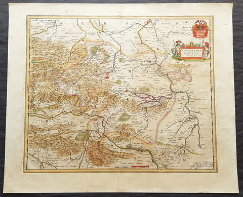
1662 Joan Blaeu Antique Map of Mansfeld Land, in SW Saxony-Anhalt, Germany
- Title : Mansfelda Comitatus Auctore Tilemanno Stella Sig.
- Ref #: 50180
- Size: 23 1/2in x 19 1/2in (600mm x 495mm)
- Date : 1662
- Condition: (A) Very Good Condition
Description:
This beautifully hand coloured original copper-plate engraved antique map of the ancient region of Mansfeld Land located in the in southwestern region of Saxony-Anhalt, Germany - centering on the city of Mansfeld - by was published in the 1662 Latin edition edition of Joan Blaeus Atlas Major.
General Definitions:
Paper thickness and quality: - Heavy and stable
Paper color : - off white
Age of map color: - Original
Colors used: - Blue, pink, red, green, yellow
General color appearance: - Authentic
Paper size: - 23 1/2in x 19 1/2in (600mm x 495mm)
Plate size: - 19 1/2in x 16 1/2in (495mm x 420mm)
Margins: - Min 1in (25mm)
Imperfections:
Margins: - Light age toning
Plate area: - Light age toning
Verso: - Light age toning
Background:
Mansfeld Land is a region in the southwestern corner of the German state of Saxony-Anhalt. The region derives its name from the counts of Mansfeld, who ruled this region for about 1,000 years.
The House of Mansfeld, whose members belonged to the Saxon nobility and served as counts in the Hassegau, was first documented in a 973 deed. The counts built Mansfeld Castle, whose foundations date back to the late 11th century, when one Hoyer of Mansfeld served as field marshal to Emperor Henry V. The first reference of the fortress coincides with the extinction of the elder line in 1229. The estates were inherited by the Lords of Querfurt, who also adopted the comital title, calling themselves Counts of Mansfeld from that time on.
The settlement of Mansfeld received town privileges in 1400, and grew through the development of copper and silver mining, an activity in which Hans Luder from Möhra, father to Martin Luther and Mansfeld citizen from 1484, was employed as a master smelter. Luthers family had arrived into a modest prosperity, he himself attended the local school between 1488 and 1496. The building known as Luther\'s School had to be torn down and rebuilt in 2000 due to structural problems. His parents house is preserved and today a museum. Luther also acted as an altar server at the St George parish church.
The Counts of Mansfeld had already lost Imperial immediacy in 1580. When the comital line finally became extinct in 1780, the estates around Mansfeld were incorporated into the Prussian Duchy of Magdeburg. The town retained the status of an independent city (Immediatstadt), it was temporarily part of the Napoleonic Kingdom of Westphalia and after the 1815 Congress of Vienna belonged to the Prussian Province of Saxony.
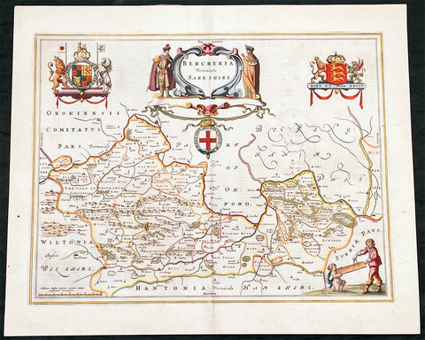
1662 Joan Blaeu Antique Map of the English County of Berkshire
Antique Map
- Title : Bercheria Vernaeule Barkshire
- Ref #: 27013
- Size: 22 1/4in x 18 1/2in (565mm x 470mm)
- Date : 1662
- Condition: (A) Very Good Condition
Description:
This original beautifully hand coloured antique map of the English County of Berkshire by Joan Blaeu was published in the 1662 edition of Atlas Major. (Ref: Tooley; M&B)
General Definitions:
Paper thickness and quality: - Heavy and stable
Paper color : - off white
Age of map color: - Original
Colors used: - Yellow, green, blue, pink
General color appearance: - Authentic
Paper size: - 22 1/4in x 18 1/2in (565mm x 470mm)
Plate size: - 19 3/4in x 15in (500mm x 380mm)
Margins: - Min 1/2in (10mm)
Imperfections:
Margins: - None
Plate area: - Small abrasion to right of map image
Verso: - Age toning
Please note all items auctioned are genuine, we do not sell reproductions. A Certificate of Authenticity (COA) can be issued on request.
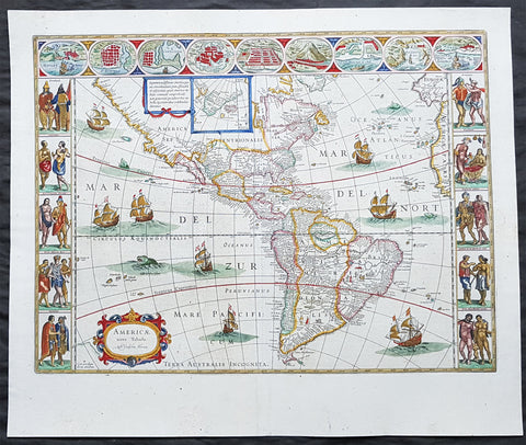
1662 Joan Blaeu Antique Map of the New World, America - Magnificent
- Title : Americae nova Tabula Auct: Guiljesino Blaeuw
- Size: 24in x 20in (610mm x 510mm)
- Condition: (A+) Fine Condition
- Date : 1662
- Ref #: 3007
Description:
This beautiful, original, hand coloured copper-plate engraved antique map, the quintessential 17th century image of America, The New World, was published in arguably the greatest atlas ever published, the 11th volume of Joan Blaeus 1662 edition of Atlas Major, or Great Atlas, Latin 1st edition.
This map was printed from a plate first produced by Joan Blaeus father, Willem in 1617 and was published in Atlas Major for only 10 years, prior to the disastrous 1672 fire that wiped out the Blaeu publishing house.
The original colouring is also extremely rare to find and this colouring is exceptional, along with heavy paper, a strong impression and original margins.
The New World, originally issued by Joan Blaeus father, Willem,. as early as 1617, this general map of the Americas was one of the longest lived plates in all the Blaeu\'s atlases, having been used as an atlas map from 1630.
Here is the general seventeenth century European view of the Western Hemisphere: the delineation of the coasts and the nomenclature of the Pacific as well as the Atlantic coasts are basically Spanish in origin and follow the maps of the Fleming Abraham Ortelius and his countryman Cornelis Wytfliet. To these, Willem Blaeu inserted, on the east coast, the English names given by the Roanoke colonists in Virginia, and by Martin Frobisher, John Davis and Henry Hudson in the far north. In Florida and along the St Lawrence, Blaeu added the names given by the French settlers, almost the only memorials to their ill-fated venture in Florida during the latter part of the sixteenth century.
When Blaeu first made his map in the early years of the seventeenth century, Europeans still had no real knowledge of the nature of the Mississippi system. From the expedition journals of Hernando de Soto (1539 - 1543) they had inferred an extensive range of mountains trending eastwards to the north of the Gulf of Mexico in la Florida apparently precluding a great river system. The Great Lakes were as yet unknown although by the time Blaeu issued this map in its atlas form in the Huron region together with the hearsay accounts from Coral Indians were becoming well known through his 1632 map of the region. Evidently, this appears to have been unknown to Blaeu at the time, but surprisingly, he never incorporated the information on later printings of the map. The same applies to Manhattan and Long Island as well, despite the fact that only a short distance from Amsterdam, the Leiden academic Johannes D Late had published the first edition of his monumental work on the Americas which provided source material for any number of maps of the Americas throughout the remainder of the century and beyond.
In common with the other general continental maps in Blaeus atlas\'s, he has provided perspective plans or views of settlements in the Americas, including Havana, St Domingo, Cartagena, Mexico, Cusco, Potisi, I.la Moca in Chile, Rio Janeiro and Olianda in Pharnambucco, as well as the vignette illustrations of native figures taken from the accounts of John White (Virginia) or Hans Staden (Brazil) and others. (Ref: Burden; RGS; Koeman; Tooley)
General Definitions:
Paper thickness and quality: - Heavy and stable
Paper color : - off white
Age of map color: - Original
Colors used: - Yellow, green, blue, pink
General color appearance: - Authentic
Paper size: - 24in x 20in (610mm x 510mm)
Plate size: - 21 1/2in x 16 1/4in (545mm x 415mm)
Margins: - Min 1in (25mm)
Imperfections:
Margins: - None
Plate area: - Light printer crease along left side of page
Verso: - Light age toning
Background:
Atlas Major or Great Atlas - During the early hours of the 23rd of February 1672, a fire broke out and engulfed a building on Gravenstraat, in the centre of Amsterdam. Such an event at the time was unremarkable, until it was recognised that the fire had brought to an end of one of the greatest publishing houses of all time. Dr Joan Blaeus family were responsible for printing and publishing some of the most important maps, atlases, religious and philosophical books, that are recognised even today, as remarkable. The fire was described in suitably vivid terms in the annual review publication, De Hollandtse Mercurius for 1672-1673
.............the disaster occurred at 3.30 on the morning of the 23rd of February because of the dryness of the timbers, or perhaps the carelessness of the apprentices; the magnificent establishment caught fire, and with it printing type, presses, plates and paper, were all burnt and sparks were sent flying as far as the Tol-heck (Toll Gate). One report put the financial cost of the damage at fl. 27, 000 for the buildings and some fl 355,000 for the plate-stock in the printing works and shop premises, to give total estimated losses of fl. 382, 000 (or about $25milUS in modern terms) together with some four or five thousand reams of paper, five or six thousand sheets, 88 thousand kg. printing type and so on...................
The fire precipitated the end of a publishing house established over 40 years before, and very probably contributed to the death of its proprietor, Alderman Dr Joan Blaeu, a year later, effectively ending the reign of one of the greatest producers of printed maps and atlases in publishing history. Only 10 years previously, in 1662, the house had reached its zenith with the publication of its greatest achievement, the Atlas Major or Great Atlas, containing 11 volumes with geographical detail reflecting many of the achievements of the Golden Ageof the United Netherlands.
Joan Blaeus 11 volume Atlas Major is considered by many to be the greatest atlas ever published, both in its own time and even today. It excels in comprehensiveness, engraving, color, and overall production. The first Latin edition was published in 1662 and was subsequently published in French, Dutch, German, and Spanish.
Most of the surviving copies of the Atlas Major are bound in what might be termed as Standard bindings, in other words, uniform cream-coloured vellum with gilt tooling and lettering. Wealthy clients for the atlas could commission a binder to bind their sets in morocco or even velvet, embellished with their crests of other decorative devices. Such bindings were carried out by the celebrated binder Albert Magnus, who flourished in Amsterdam from the 1660s to 1680. As it appears that Joan Blaeu had no bindery on his premises, it is very likely that Magnus also bound copies in the standard binding.
Colour was also a very important consideration. Although the atlas was published in black and white, and could be bought so (without hand colouring) many clients buying the atlas for display in their houses proffered their copies illuminated with rich hand colouring and sometime with gold high lightening. This of course was considerably more expensive, and there were in Amsterdam at the time artists who carried out such work. One of these was Dirk Janszoon van Santen who coloured and gilded maps and atlases to order, examples of which have survived and may be seen in institutional collections.
Blaeus atlas was the most expensive printed book in the 17th century. Blaeus catalogue of 1670, his Catalogue des Atlas, Theatre des Citez, quoted prices for the 12 volume French Text edition of the atlas at fl. 450 for a coloured set, and fl. 350 for a black and white set. This is the equivalent of paying around $70,000 today (although to purchase today at auction could be well over $250,000)
The original 11 volumes of Atlas Majorcontained the following contents:
v 1. Arctica --Europa, liber 1-2:. Norvegia. Dania. Sleswic
v. 2. Europa, liber 3-7: Suecia. Russia. Polonia. Regiones orientales ultra Germaniam circa Danubium. Graecia
v. 3. Europa, liber 8: Germania
v. 4. Europa, liber 9-10: Belgica regia
v. 5. Europa, liber 11: Anglia
v. 6. Europa, liber 12-13: Scotia. Hibernia
v. 7. Europa, liber 14-15: Gallia. Helvetia
v. 8. Europa, liber 16: Italia
v. 9. Europa, liber 17: Hispania. Africa
v. 10. Asia
v. 11. America.
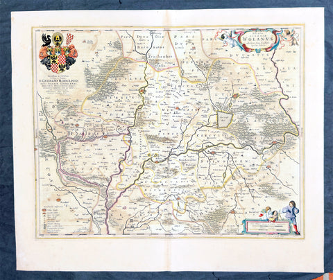
1662 Joan Blaeu Antique Map of Wołow County, Lower Silesia Voivodeship SW Poland
Antique Map
- Title : Ducatus Silesiae Wolanus Authore Jona Sculteto Sprotta Silesio
- Ref #: 93430
- Size: 24in x 20in (610mm x 510mm)
- Date : 1662
- Condition: (A) Very Good Condition
Description:
This beautifully hand coloured original copper-plate engraved antique, rare map of Wolow County, located at the time of publication in the Duchy of Głogow, in Lower Silesia, today SW Poland, was published in Joan Blaeu greatest publication, the first 1662 French edition of Atlas Major,.
As this map was only published over a 10 year period, as most of the plates were destroyed in the disasterous 1672 fire that wiped out the Blaeu publishing house, this map is extremely rare especially with original hand colour, such as this map.
General Definitions:
Paper thickness and quality: - Heavy and stable
Paper color : - off white
Age of map color: - Original
Colors used: - Yellow, green, blue, pink
General color appearance: - Authentic
Paper size: - 24in x 20in (610mm x 510mm)
Plate size: - 21in x 16 1/2in (535mm x 420mm)
Margins: - Min 1in (25mm)
Imperfections:
Margins: - Light soiling
Plate area: - Offsetting
Verso: - Offsetting
Background:
Wolow is a town in Lower Silesian Voivodeship in south-western Poland. It is the seat of Wołów County and Gmina Wołów. It lies approximately 38 kilometres north-west of the regional capital Wrocław.
The area around Wołów has been settled since prehistoric times. It became part of the emerging Polish state in the late 10th century under Mieszko I of Poland. The town was first mentioned in 1157 when a wooden castle founded by Senior Duke of Poland Władysław II the Exile is documented, which developed into a castle complex, which was again mentioned in 1202. Two villages developed near the castle, one of them called Wołowo. Probably in the second half of the 13th century the town was founded near Wołowo and partially on the soil of the second village. Wołów received Magdeburg town rights about 1285 at the time of German Ostsiedlung in the region; a Vogt is mentioned in 1288.
At that time Wołów belonged to the Duchy of Głogów, after 1312 to the Duchy of Oleśnica. With the duchy it came under the suzerainty of Bohemia in 1328. From 1473 dates the oldest known seal of the town, which already shows an ox, as do all later seals. Wołów was ruled by local Polish dukes until 1492, and soon after, in 1495, it came into the possession of the Czech Podiebrad family, then in 1517 it came into the hands the Hungarian magnate Johann Thurzó, before returning to Piast rule in 1523, by passing to the Duchy of Legnica. It remained there until the Piast dukes of Legnica-Brzeg-Wołów died out in 1675. As a result of the Thirty Years War, the towns population fell by half.
The Protestant Reformation was introduced to the town in 1522 by duke Frederick II. After the extinction of the local Piasts the duchy passed to the House of Habsburg, which opposed the Protestant denomination in the town, as part of the Counter-Reformation. In 1682 the towns parish church was closed and given to the Catholics. According to the Treaty of Altranstädt the church however was already returned to the Protestants in 1707 and stayed Protestant until 1945. The small Catholic minority in return received a Josephinian curacy.
In 1742 Wołów was annexed by Prussia. The duchy was divided into two districts and the town became county seat of one of the districts. The structure of the town was, until 1700, defined by craft, especially clothiers. As the seat of a duchy and a district administrative function however became more and more important. The industrialization played only a minor role and mostly affected smaller companies of the timber industry. In 1781 the city suffered a fire.
The town was part of Germany from 1871 to 1945. In January 1945 – just before town was taken by the Red Army – the Wehrmacht evacuated the German population westwards.

1662 Joan Blaeu Complete Set of 9 Antique Maps of North America from Atlas Major, 1st Edition
Antique Map
- Titles:
1. Extrema Americae....Terra Nova Francia;
2. Nova Belgica Et Anglia Nova;
3. Nova Virginiae Tabula;
4. Virginiae partis australis, et Floridae;
5. Nova Hispania;
6. Yucatan...Guatimala;
7. Insulae Americanae;
8. Canibales Insulae;
9. Mappa Aestivarum Insularum Alias Barmudas - Sizes: 24in x 20 1/2in (610mm x 520mm)ea
- Condition: (A+) Fine Condition
- Date: 1662
- Ref #: BlaeuNA 1662
Description:
This is a unique opportunity to acquire a complete set of 9 maps of North America published by Joan Blaeus in the monumental & rare 1st 1662 Latin edition of Atlas Major. The maps cover the geographical detail of Canada, North America, Mexico, The Caribbean & Central America. Please see the background section below for details of each map. All maps have wide original margins & colour on strong sturdy paper.
Joan Blaeus 11 volumes of Atlas Major, is considered by many to be the greatest atlas set ever published. It excels in comprehensiveness, engraving, color, and overall production. The first edition was published in Latin in 1662 and was subsequently published in French, Dutch, German, and Spanish over the next 10 years.
On the 23rd of February 1672, a fire broke out in central Amsterdam, that ended the reign of one of the greatest & most prolific publishers of printed maps and atlases in publishing history. The Blaeu family had reached its zenith 10 years previously, with the publication of its greatest achievement, the Atlas Major or Great Atlas, consisting of 11 volumes, with geographical detail reflecting many of the achievements of the Golden Age of the United Netherlands. Blaeus Atlas Major were the most expensive books printed in the 17th century.
General Definitions:
Paper thickness and quality: - Heavy and stable
Paper color : - off white
Age of map color: - Original
Colors used: - Blue, pink, red, green, yellow
General color appearance: - Authentic
Paper size: - 24in x 20 1/2in (610mm x 520mm)
Plate size: - Various, pls see below
Margins: - Min 1in (25mm) min
Imperfections:
Margins: - Pls see below
Plate area: - Pls see below
Verso: - Pls see below
Background:
1. Extrema Americae ( Eastern Canada) - Rare only published in Atlas Major. Derived mainly from the Samuel de Champlain Nouvelle France map of 1632, this map reflects the growing financial importance of the waters of New France to Europe.
Plate: 22 1/2in x 17 3/4in.
Condition: Age toning, text show-through & browning to image.
2. Nova Belgica Et Anglia Nova (New England) - NE America, centering on New York and Manhattan from Virginia to the St Lawrence River. This map is noted for the fact that its primary source is the first manuscript figurative map of Adriaen Block from 1614. Indeed it is the first full representation of it in print. It is one of the earliest to name Nieu Amsterdam. Block, a Dutch fur trader, explored the area between Cape Cod and Manhattan, examining the bays and rivers along the way.
Plate: 19 1/2in x 15 1/2in
Condition: Age toning, text show-through & browning to image.
3. Nova Virginiae Tabula (John Smiths Virginia & Chesapeake Bay) This map was printed from a plate engraved by Dirk Grijp from a previous plates by Henricus Hondius.
Plate: 19in x 15in
Condition: Light age toning
4. Virginiae partis australis, et Floridae Virginia, the Carolinas & Georgia.
Plate: 20in x 15in
Condition: Light age toning
5. Nova Hispania et Nova Galicia Western Mexico
Plate: 19 1/2in x 15 1/2in
Condition: Light age toning
6. Yucatan...Guatimala (Yucatan, Central America) Rare only published in Atlas Major.
Plate: 20 1/2in x 16 1/2in
Condition: Light age toning
7. Insulae Americana (GOM, Caribbean)
Plate: 20 1/2in x 15in
Condition: Light age toning
8. Canibales Insulae (Lesser Antilles Islands) Rare, printed only in Atlas Major
Plate: 21in x 16 1/2in
Condition: Age toning
9. Mappa Aestivarum Insularum Alias Barmudas Dictarum Bermuda. Like all 17th century maps of Bermuda this map is based ultimately on the survey made by John Norwood, of the Bermuda Company, in 1618 in the form as published by the English map-maker John Speed in 1627.
Plate: 21in x 16in
Condition: Light age toning
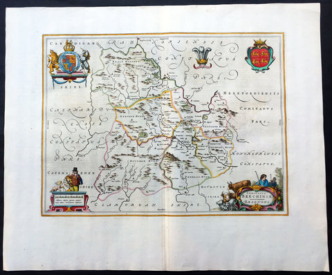
1664 Blaeu Large Antique Map of The Welsh County of Breknock
- Title : Comitatus Brechiniae Breknoke
- Ref #: 01-4244
- Size: 25 1/2in x 21 1/2in (650mm x 545mm)
- Date : 1664
- Condition: (A+) Fine Condition
Description:
This beautifully hand coloured original antique map of the Welsh county of Brecknock was published in the 1664 Dutch edition of Joan Blaeus Atlas Major.
Blaeus reference for the topographical data is from John Speeds maps from the 1611 Empire of Great Britaine - the beautiful decoration, though, is distinctly Blaeus.
This is a beautiful map with a deep impression, original margins, wonderful hand colouring and strong, stable paper. (Ref: Koeman; Tooley; M&B)
General Description:
Paper thickness and quality: - Heavy and stable
Paper color: - White
Age of map color: - Later
Colors used: - Yellow, pink, red, blue, green
General color appearance: - Authentic
Paper size: - 25 1/2in x 21 1/2in (650mm x 545mm)
Plate size: - 20in x 15in (510mm x 380mm)
Margins: - Min 2in (50mm)
Imperfections:
Margins: - None
Plate area: - None
Verso: - None
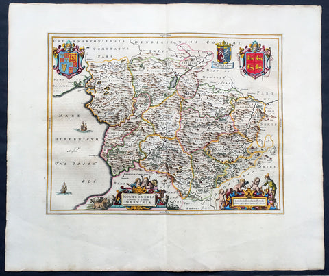
1664 Joan Blaeu Large Antqiue Map The Welsh County of Montgomery
Antique Map
-
Title : Montgomeria Comitatus et Comitatus Mervinia
- Date : 1664
- Condition: (A+) Fine Condition
- Ref: 01-4004
- Size: 25 1/2in x 21 1/2in (650mm x 545mm)
Description:
This beautifully hand coloured original antique map of the Welsh County of Montgomery was published in the 1664 Dutch edition of Joan Blaeus Atlas Major.
Blaeus reference for the topographical data is from John Speeds maps from the 1611 Empire of Great Britaine - the beautiful decoration, though, is distinctly Blaeus. (Ref: Koeman; Tooley; M&B)
General Description:
Paper thickness and quality: - Heavy and stable
Paper color: - White
Age of map color: - Early
Colors used: - Yellow, pink, red, blue, green
General color appearance: - Authentic
Paper size: - 25 1/2in x 21 1/2in (650mm x 545mm)
Plate size: - 20in x 16 1/2in (510mm x 420mm)
Margins: - Min 2in (50mm)
Imperfections:
Margins: - None
Plate area: - None
Verso: - None
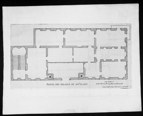
1665 De Rossi Original Antique Architectural Plan, Print of Alfieri, Asti Palace Monferrato, Italy
- Title : Pianta Del Palazzo De Sig. D ' Asti
- Date : 1665
- Condition: (A+) Fine Condition
- Ref: 91195
- Size: 18in x 14in (460mm x 360mm)
Description:
This finely engraved original antique architectural engraving a plan of the Alfieri (Asti) Palace in Monferrato, Italy by Giovanni Battistaa Falda was published by Giacomo de Rossi in the 1665 edition of Il nuovo teatro delle fabriche, et edificii, in prospettiva di Roma moderna, 1665-1699.
These original prints are published on beautiful heavy clean original 17th century laid Italian made paper.
Palazzo Alfieri (Asti)An ancient noble home from the 13th century. In 1738, the owner, Antonio Amedeo Alfieri, decided to alter the size and restore the property, an assignment which he entrusted to his illustrious cousin, Benedetto Alfieri, who had become, in the meantime, the royal architect. Benedetto began to work on the building, transforming it into a grandiose and complex palace with a trapezoid courtyard, a garden, and an imposing façade. Eleven years later, in this very palace, the great poet Vittorio Alfieri was born, who spent part of this life here until he decided to leave the sleepy province in search of more meaningful experiences.
The palace was acquired in 1901 by Conte Ottolenghi, who then donated it to the city, which turned it into a Museo in order to give the Museo Alfieriano a seat. Today, the Centro Nazionale di Studi Alfieriani (National Center of Alfierian Studies), the Biblioteca Astense (Asti Library), and the Istituto per la Storia della Resistenza (Institute for the History of the Resistance) all have their seats here.
General Definitions:
Paper thickness and quality: - Heavy and stable
Paper color : - off white
Age of map color: -
Colors used: -
General color appearance: -
Paper size: - 18in x 14in (460mm x 360mm)
Plate size: - 11 1/2in x 9in (290mm x 230mm)
Margins: - Min 1/2in (12mm)
Imperfections:
Margins: - None
Plate area: - None
Verso: - None
Background:
Il Nuovo Teatro: One of the most important architectural projects of the seventeenth century was the urban renovation of Rome. Under the brilliant leadership of Pope Alessandro VII (1655-1667), Rome dramatically emerged as one of the most modern and beautiful cities of the new Baroque age. Within several decades spacious roadways were constructed, monumental buildings arose, and many public squares appeared with elaborate fountains and monuments. To be sure, this massive undertaking was meant to underline the absolute power of the Papacy but it also brought forth a new flowering of Italian art and architecture.
The Nuovo Teatro was initiated in 1665 to depict the new Rome in a series of etchings. What it gave to future generations was a magnificent historical record of views etched by two of Italy's greatest architectural artists. The printing and publishing of these important etchings was entrusted to Giacomo de Rossi (1626-1691), the head of the most dominant Roman publishing house. Sons and nephews of de Rossi, in fact, continued the publishing house until 1738 when the business was sold to Pope Clement XII to form the basis of the Regia Calcografia.) Altogether, four sets of Nuovo Teatro were created during the seventeenth century. Volumes one (35 etchings) and two (17 etchings) were both published in the year of 1665 and dealt mainly in views of the new piazzas, gardens, terraces and their surrounding buildings. Volume 3 (38 etchings) was published in 1669 and concentrated upon the newly constructed churches of Rome. Every plate from the first three sets was both designed and etched by the influential architectural artist, Giovanni Battista Falda (1643-1678). For reasons unknown the fourth and final volume (52 etchings) did not appear until 1699. It was published by Giacomo's successor, Domenico de Rossi, and featured views of the palaces and stately homes of Rome. Each plate was designed and etched by the famous architect and etcher, Alessandro Specchi (1668-1729)
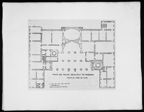
1665 De Rossi Original Antique Architectural Plan, Print of Barberini Palace, Rome Italy
- Title : Pianta Del Palazz Del'Gli Ecc Sig, Barberini
- Date : 1665
- Condition: (A+) Fine Condition
- Ref: 91184
- Size: 18in x 14in (460mm x 360mm)
Description:
This finely engraved original antique architectural engraving a plan of Barberini Palace Rome, Italy by Giovanni Battistaa Falda was published by Giacomo de Rossi in the 1665 edition of Il nuovo teatro delle fabriche, et edificii, in prospettiva di Roma moderna, 1665-1699.
These original prints are published on beautiful heavy clean original 17th century laid Italian made paper inlaid with a Fleur-de-Lis watermark.
The Palazzo Barberini is a 17th-century palace in Rome, facing the Piazza Barberini in Rione Trevi. It houses the Galleria Nazionale d'Arte Antica.
The sloping site had formerly been occupied by a garden-vineyard of the Sforza family, in which a palazzetto had been built in 1549. The sloping site passed from one cardinal to another during the sixteenth century, with no project fully getting off the ground.
When Cardinal Alessandro Sforza met financial hardships, the still semi-urban site was purchased in 1625 by Maffeo Barberini, of the Barberini family, who became Pope Urban VIII.
Three great architects worked to create the Palazzo, each contributing his own style and character to the building. Carlo Maderno, then at work extending the nave of St Peter's, was commissioned to enclose the Villa Sforza within a vast Renaissance block along the lines of Palazzo Farnese; however, the design quickly evolved into a precedent-setting combination of an urban seat of princely power combined with a garden front that had the nature of a suburban villa with a semi-enclosed garden.
Maderno began in 1627, assisted by his nephew Francesco Borromini. When Maderno died in 1629, Borromini was passed over and the commission was awarded to Bernini, a young prodigy then better known as a sculptor. Borromini stayed on regardless and the two architects worked together, albeit briefly, on this project and at the Palazzo Spada. Works were completed by Bernini in 1633.
After the Wars of Castro and the death of Urban VIII, the palace was confiscated by Pamphili Pope Innocent X and was only returned to the Barberini in 1653.
General Definitions:
Paper thickness and quality: - Heavy and stable
Paper color : - off white
Age of map color: -
Colors used: -
General color appearance: -
Paper size: - 18in x 14in (460mm x 360mm)
Plate size: - 11 1/2in x 9in (290mm x 230mm)
Margins: - Min 1/2in (12mm)
Imperfections:
Margins: - None
Plate area: - None
Verso: - None
Background:
Il Nuovo Teatro: One of the most important architectural projects of the seventeenth century was the urban renovation of Rome. Under the brilliant leadership of Pope Alessandro VII (1655-1667), Rome dramatically emerged as one of the most modern and beautiful cities of the new Baroque age. Within several decades spacious roadways were constructed, monumental buildings arose, and many public squares appeared with elaborate fountains and monuments. To be sure, this massive undertaking was meant to underline the absolute power of the Papacy but it also brought forth a new flowering of Italian art and architecture.
The Nuovo Teatro was initiated in 1665 to depict the new Rome in a series of etchings. What it gave to future generations was a magnificent historical record of views etched by two of Italy's greatest architectural artists. The printing and publishing of these important etchings was entrusted to Giacomo de Rossi (1626-1691), the head of the most dominant Roman publishing house. Sons and nephews of de Rossi, in fact, continued the publishing house until 1738 when the business was sold to Pope Clement XII to form the basis of the Regia Calcografia.) Altogether, four sets of Nuovo Teatro were created during the seventeenth century. Volumes one (35 etchings) and two (17 etchings) were both published in the year of 1665 and dealt mainly in views of the new piazzas, gardens, terraces and their surrounding buildings. Volume 3 (38 etchings) was published in 1669 and concentrated upon the newly constructed churches of Rome. Every plate from the first three sets was both designed and etched by the influential architectural artist, Giovanni Battista Falda (1643-1678). For reasons unknown the fourth and final volume (52 etchings) did not appear until 1699. It was published by Giacomo's successor, Domenico de Rossi, and featured views of the palaces and stately homes of Rome. Each plate was designed and etched by the famous architect and etcher, Alessandro Specchi (1668-1729)
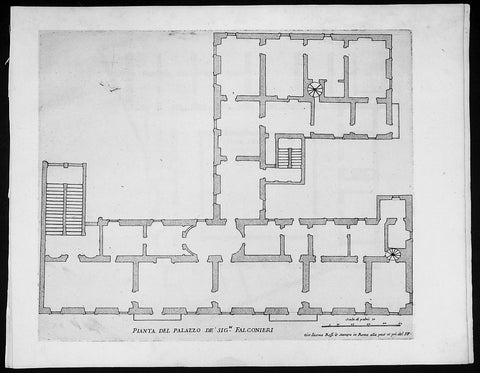
1665 De Rossi Original Antique Architectural Plan, Print of Falconieri Palace, Rome, Italy
- Title : Pianta Del Palazzo De Sig. Falconieri
- Date : 1665
- Condition: (A+) Fine Condition
- Ref: 91192
- Size: 18in x 14in (460mm x 360mm)
Description:
This finely engraved original antique architectural engraving a plan of the Falconieri Palace Rome, Italy by Giovanni Battistaa Falda was published by Giacomo de Rossi in the 1665 edition of Il nuovo teatro delle fabriche, et edificii, in prospettiva di Roma moderna, 1665-1699.
These original prints are published on beautiful heavy clean original 17th century laid Italian made paper.
Palazzo Falconieri is a palace in Rome, Italy formed in the seventeenth century as a result of remodelling by the Baroque architect Francesco Borromini. It is the home of the Hungarian Academy Rome(which is the Rome office of the Balassi Institute), since its foundation in 1927. It is located between Via Giulia and Lugotevere, with entrances to both; it is near Plazzo Farnese and a few houses down and across Via Giulia from the church of Santa Caterina a Magnanapoli in the Rione of Regola. From 1814, it was occupied by cardinal Joseph Fesch, Napoleon's uncle.
In 1638, Orazio Falconieri purchased a palace on the Via Giulia which had a small courtyard facing the River Tiber. He bought an adjacent property in 1645 and in 1646 and appointed the architect Francesco Borromini to remodel and refurbish the two. Some of Borromini’s work was lost in the nineteenth century development of Lungotevere, the embankment and road between the Tiber and the buildings which overlook it, but parts remain.
The surviving parts of Borromini’s work include the façade to the Via Giulia, the Belvedere overlooking the Tiber and the decorative work in several rooms. On the façade, the number of bays was increased from seven to eleven and at either end, tall inverted fluted pilasters were placed terminating in falcons heads, a reference to the family name, that each look back at the façade. Overlooking the Tiber, Borromini added a Belvedere, a three bay loggia with Serliana openings, that stands above the surrounding buildings. On the interior, some of the rooms are ornamented with stucco work designed by Borromini, with the frequent use of heraldic devices and symbolic motifs
General Definitions:
Paper thickness and quality: - Heavy and stable
Paper color : - off white
Age of map color: -
Colors used: -
General color appearance: -
Paper size: - 18in x 14in (460mm x 360mm)
Plate size: - 11 1/2in x 9in (290mm x 230mm)
Margins: - Min 1/2in (12mm)
Imperfections:
Margins: - None
Plate area: - None
Verso: - None
Background:
Il Nuovo Teatro: One of the most important architectural projects of the seventeenth century was the urban renovation of Rome. Under the brilliant leadership of Pope Alessandro VII (1655-1667), Rome dramatically emerged as one of the most modern and beautiful cities of the new Baroque age. Within several decades spacious roadways were constructed, monumental buildings arose, and many public squares appeared with elaborate fountains and monuments. To be sure, this massive undertaking was meant to underline the absolute power of the Papacy but it also brought forth a new flowering of Italian art and architecture.
The Nuovo Teatro was initiated in 1665 to depict the new Rome in a series of etchings. What it gave to future generations was a magnificent historical record of views etched by two of Italy's greatest architectural artists. The printing and publishing of these important etchings was entrusted to Giacomo de Rossi (1626-1691), the head of the most dominant Roman publishing house. Sons and nephews of de Rossi, in fact, continued the publishing house until 1738 when the business was sold to Pope Clement XII to form the basis of the Regia Calcografia.) Altogether, four sets of Nuovo Teatro were created during the seventeenth century. Volumes one (35 etchings) and two (17 etchings) were both published in the year of 1665 and dealt mainly in views of the new piazzas, gardens, terraces and their surrounding buildings. Volume 3 (38 etchings) was published in 1669 and concentrated upon the newly constructed churches of Rome. Every plate from the first three sets was both designed and etched by the influential architectural artist, Giovanni Battista Falda (1643-1678). For reasons unknown the fourth and final volume (52 etchings) did not appear until 1699. It was published by Giacomo's successor, Domenico de Rossi, and featured views of the palaces and stately homes of Rome. Each plate was designed and etched by the famous architect and etcher, Alessandro Specchi (1668-1729)
1665 De Rossi Original Antique Architectural Plan, Print of Galleria Spada, Rome Italy
- Title : Pianta Del Palazzo Del Em. Sigre Cardle Spada
- Date : 1665
- Condition: (A+) Fine Condition
- Ref: 91178
- Size: 18in x 14in (460mm x 360mm)
Description:
This finely engraved original 1655 antique architectural engraving a plan of the Galleria Spada Museum in Rome, Italy by Giovanni Battistaa Falda was published by Giacomo de Rossi in the 1665 edition of Il nuovo teatro delle fabriche, et edificii, in prospettiva di Roma moderna, 1665-1699.
These original prints are published on beautiful heavy clean original 17th century laid Italian made paper.
Galleria Spada is a museum in Rome (Italy), which is housed in the Palazzo Spada of the same name, located in the Piazza Capo di Ferro. The palazzo is also famous for its façade and for the forced perspective gallery by Francesco Borromini. The gallery exhibits paintings from the 16th and 17th century.
It was originally built in 1540 for Cardinal Girolamo Capodiferro. Bartolomeo Baronino, of Casale Monferrato, was the architect, while Giulio Mazzoni and a team provided lavish stuccowork inside and out. The palazzo was purchased by Cardinal Spada in 1632. He commissioned the Baroque architect Francesco Borromini to modify it for him, and it was Borromini who created the masterpiece of forced perspective optical illusion in the arcaded courtyard, in which diminishing rows of columns and a rising floor create the visual illusion of a gallery 37 meters long (it is 8 meters) with a lifesize sculpture at the end of the vista, in daylight beyond: the sculpture is 60 cm high. Borromini was aided in his perspective trick by a mathematician. The building was purchased in November 1926 by the Italian State to house the gallery and the State Council. The Galleria was opened in 1927 in the Palazzo Spada. It closed during the 1940s, but reopened in 1951 thanks to the efforts of the Conservator of the Galleries of Rome, Anchille Bertini Calosso and the Director, Frederico Zeri. Zeri was committed to locating the remaining artwork that had been scattered during the war, as he intended to recreate the original layout of the 16th-17th version of the gallery, including the placement of the pictures, the furniture and the sculptures. Most of the exhibited artwork comes predominantly from the private collection of Bernardino Spada, supplemented by smaller collections such as that of Virgilio Spada
General Definitions:
Paper thickness and quality: - Heavy and stable
Paper color : - off white
Age of map color: -
Colors used: -
General color appearance: -
Paper size: - 18in x 14in (460mm x 360mm)
Plate size: - 11 1/2in x 9in (290mm x 230mm)
Margins: - Min 1/2in (12mm)
Imperfections:
Margins: - None
Plate area: - None
Verso: - None
Background:
Il Nuovo Teatro: One of the most important architectural projects of the seventeenth century was the urban renovation of Rome. Under the brilliant leadership of Pope Alessandro VII (1655-1667), Rome dramatically emerged as one of the most modern and beautiful cities of the new Baroque age. Within several decades spacious roadways were constructed, monumental buildings arose, and many public squares appeared with elaborate fountains and monuments. To be sure, this massive undertaking was meant to underline the absolute power of the Papacy but it also brought forth a new flowering of Italian art and architecture.
The Nuovo Teatro was initiated in 1665 to depict the new Rome in a series of etchings. What it gave to future generations was a magnificent historical record of views etched by two of Italy's greatest architectural artists. The printing and publishing of these important etchings was entrusted to Giacomo de Rossi (1626-1691), the head of the most dominant Roman publishing house. Sons and nephews of de Rossi, in fact, continued the publishing house until 1738 when the business was sold to Pope Clement XII to form the basis of the Regia Calcografia.) Altogether, four sets of Nuovo Teatro were created during the seventeenth century. Volumes one (35 etchings) and two (17 etchings) were both published in the year of 1665 and dealt mainly in views of the new piazzas, gardens, terraces and their surrounding buildings. Volume 3 (38 etchings) was published in 1669 and concentrated upon the newly constructed churches of Rome. Every plate from the first three sets was both designed and etched by the influential architectural artist, Giovanni Battista Falda (1643-1678). For reasons unknown the fourth and final volume (52 etchings) did not appear until 1699. It was published by Giacomo's successor, Domenico de Rossi, and featured views of the palaces and stately homes of Rome. Each plate was designed and etched by the famous architect and etcher, Alessandro Specchi (1668-1729)
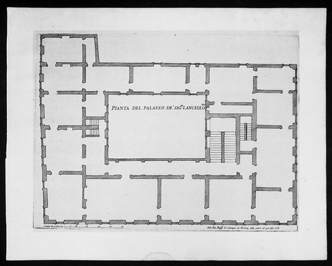
1665 De Rossi Original Antique Architectural Plan, Print of Lancellotti Palace, Rome Italy
- Title : Pianta Del Palazzo De Sig. Lancello
- Date : 1665
- Condition: (A+) Fine Condition
- Ref: 91196
- Size: 18in x 14in (460mm x 360mm)
Description:
This finely engraved original 1665 antique architectural plan of the Lancellotti Palace, also known as de Torres, in Rome, Italy by Giovanni Battistaa Falda, was published by Giacomo de Rossi in the 1665 edition of Il nuovo teatro delle fabriche, et edificii, in prospettiva di Roma moderna published in its between 1665-1699.
These original prints are published on beautiful heavy clean original 17th century laid Italian made paper inlaid with a Fleur-de-Lis watermark.
Palazzo Torres Massimo Lancellotti(Lancellotti Palace, also known as de Torres) was built for the Spanish family Torres by P.Ligorio in 1560. The palace is irregular and has ten sides with the longest one on Via della Posta Vecchia. The main facades are one the Piazza Navona and Via della Cuccagna. The windows on the noble floor are of the 15th century type, while in the rest of the palace, of the 16th century.
The Palazzo Torres Lancellotti was designed by Francesco da Volterra, and completed by Carlo Maderno. The latter was most probably also responsible for the decorative scheme of the courtyard of which the collection of sculpture forms an integral part. Palazzo Mattei, also a work of Carlo Maderno, reflects similar decorative features in the courtyard and similar ideas.
Interior is characterized by beautiful halls with the carved ceilings. In the end of the 18th century the main hall was used as a theatre; and several decades before the palace housed Chamber printing-office.
The building, an example of late-Renaissance architecture, features an interesting main façade with three orders of eleven travertine windows, decorated by and topped by a cornice. The building is accessed through an imposing portal sided by columns and topped by a balcony, leading to a courtyard that has columns on one side and is decorated with plants, ancient reliefs and stuccoes.
The loggia features some statues that represent the remains of a great collection: it included the statue of Pudicitia, Diana Efesina and the bas-relief of Medea, now hosted in the Vatican Museums. Inside the palace, it is possible to admire the wonderful frescoes by Agostino Tassi and Guercino con landscapes, allegories and views.
General Definitions:
Paper thickness and quality: - Heavy and stable
Paper color : - off white
Age of map color: -
Colors used: -
General color appearance: -
Paper size: - 18in x 14in (460mm x 360mm)
Plate size: - 11 1/2in x 9in (290mm x 230mm)
Margins: - Min 1/2in (12mm)
Imperfections:
Margins: - None
Plate area: - None
Verso: - None
Background:
Il Nuovo Teatro: One of the most important architectural projects of the seventeenth century was the urban renovation of Rome. Under the brilliant leadership of Pope Alessandro VII (1655-1667), Rome dramatically emerged as one of the most modern and beautiful cities of the new Baroque age. Within several decades spacious roadways were constructed, monumental buildings arose, and many public squares appeared with elaborate fountains and monuments. To be sure, this massive undertaking was meant to underline the absolute power of the Papacy but it also brought forth a new flowering of Italian art and architecture.
The Nuovo Teatro was initiated in 1665 to depict the new Rome in a series of etchings. What it gave to future generations was a magnificent historical record of views etched by two of Italy's greatest architectural artists. The printing and publishing of these important etchings was entrusted to Giacomo de Rossi (1626-1691), the head of the most dominant Roman publishing house. Sons and nephews of de Rossi, in fact, continued the publishing house until 1738 when the business was sold to Pope Clement XII to form the basis of the Regia Calcografia.) Altogether, four sets of Nuovo Teatro were created during the seventeenth century. Volumes one (35 etchings) and two (17 etchings) were both published in the year of 1665 and dealt mainly in views of the new piazzas, gardens, terraces and their surrounding buildings. Volume 3 (38 etchings) was published in 1669 and concentrated upon the newly constructed churches of Rome. Every plate from the first three sets was both designed and etched by the influential architectural artist, Giovanni Battista Falda (1643-1678). For reasons unknown the fourth and final volume (52 etchings) did not appear until 1699. It was published by Giacomo's successor, Domenico de Rossi, and featured views of the palaces and stately homes of Rome. Each plate was designed and etched by the famous architect and etcher, Alessandro Specchi (1668-1729)
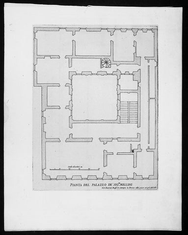
1665 De Rossi Original Antique Architectural Plan, Print of Millini Palace, Rome, Italy
- Title : Pianta Del Palazzo De Sig. Mellini
- Date : 1665
- Condition: (A+) Fine Condition
- Ref: 91194
- Size: 18in x 14in (460mm x 360mm)
Description:
This finely engraved original antique architectural engraving a plan of the Palace owned by the Mellini or Millini family in Rome, Italy by Giovanni Battistaa Falda was published by Giacomo de Rossi in the 1665 edition of Il nuovo teatro delle fabriche, et edificii, in prospettiva di Roma moderna, 1665-1699.
These original prints are published on beautiful heavy clean original 17th century laid Italian made paper.
General Definitions:
Paper thickness and quality: - Heavy and stable
Paper color : - off white
Age of map color: -
Colors used: -
General color appearance: -
Paper size: - 18in x 14in (460mm x 360mm)
Plate size: - 11 1/2in x 9in (290mm x 230mm)
Margins: - Min 1/2in (12mm)
Imperfections:
Margins: - None
Plate area: - None
Verso: - None
Background:
Il Nuovo Teatro: One of the most important architectural projects of the seventeenth century was the urban renovation of Rome. Under the brilliant leadership of Pope Alessandro VII (1655-1667), Rome dramatically emerged as one of the most modern and beautiful cities of the new Baroque age. Within several decades spacious roadways were constructed, monumental buildings arose, and many public squares appeared with elaborate fountains and monuments. To be sure, this massive undertaking was meant to underline the absolute power of the Papacy but it also brought forth a new flowering of Italian art and architecture.
The Nuovo Teatro was initiated in 1665 to depict the new Rome in a series of etchings. What it gave to future generations was a magnificent historical record of views etched by two of Italy's greatest architectural artists. The printing and publishing of these important etchings was entrusted to Giacomo de Rossi (1626-1691), the head of the most dominant Roman publishing house. Sons and nephews of de Rossi, in fact, continued the publishing house until 1738 when the business was sold to Pope Clement XII to form the basis of the Regia Calcografia.) Altogether, four sets of Nuovo Teatro were created during the seventeenth century. Volumes one (35 etchings) and two (17 etchings) were both published in the year of 1665 and dealt mainly in views of the new piazzas, gardens, terraces and their surrounding buildings. Volume 3 (38 etchings) was published in 1669 and concentrated upon the newly constructed churches of Rome. Every plate from the first three sets was both designed and etched by the influential architectural artist, Giovanni Battista Falda (1643-1678). For reasons unknown the fourth and final volume (52 etchings) did not appear until 1699. It was published by Giacomo's successor, Domenico de Rossi, and featured views of the palaces and stately homes of Rome. Each plate was designed and etched by the famous architect and etcher, Alessandro Specchi (1668-1729)
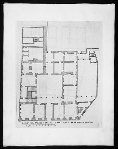
1665 De Rossi Original Antique Architectural Plan, Print of Palazzo Madama Rome, Italy
- Title : Pianta Del Palazzo Del Ser G Duca Di Toscana in Piazza Madama
- Date : 1665
- Condition: (A+) Fine Condition
- Ref: 91182
- Size: 18in x 14in (460mm x 360mm)
Description:
This finely engraved original antique architectural print of the Madama Palace in Rome, Italy by Giovanni Battista Falda was published by Giacomo de Rossi in the 1665 edition of Il nuovo teatro delle fabriche, et edificii, in prospettiva di Roma moderna, 1665-1699
These original prints are published on beautiful heavy clean original 17th century laid Italian made paper.
Palazzo Madama in Rome is the seat of the Senate of the Italian Republic. It was built atop the ruins of the ancient baths of Nero, next to Piazza Navona. The terrain had been acquired in the Middle Ages by the monks of the Abbey of Farfa, who later ceded it to France.
The new building was begun at the end of the 15th century and completed in 1505, for the Medici family. It housed two Medici cardinals and cousins, Giovanni and Giulio, who both later became popes as Leo X and Clement VII, respectively. Catherine de' Medici, Clement VII's niece, also lived here before she was married to Henry, son of King Francis I of France in 1533. Cardinal Francesco Maria Del Monte, patron of the artist Caravaggio, lived there until his death in 1627.
The palace takes its name from Madama Margherita of Austria, illegitimate daughter of Emperor Charles V, who married another illegitimate son, Alessandro de' Medici and, after his death, Ottavio Farnese. Thus part of the art collection of the Florentine Medici family was inherited by the Farnese family.
The current façade was built in the mid-1650s by both Cigoliand Paolo Maruccelli. The latter added the ornate cornice and whimsical decorative urns on the roof.
After the extinction of the Medici in 1743, the palace was handed over to the House of Lorraine and, later, to Pope Benedict XIV, who made it the seat of the Papal Government. In 1849, Pius IX moved here the Ministries of Finances and of the Public Debt, as well as the Papal Post Offices. In 1871, after the conquest of Rome by the newly formed Kingdom of Italy, the palazzo became the seat of the Senato del Regno.
General Definitions:
Paper thickness and quality: - Heavy and stable
Paper color : - off white
Age of map color: -
Colors used: -
General color appearance: -
Paper size: - 18in x 14in (460mm x 360mm)
Plate size: - 11 1/2in x 9in (290mm x 230mm)
Margins: - Min 1/2in (12mm)
Imperfections:
Margins: - None
Plate area: - None
Verso: - None
Background:
Il Nuovo Teatro: One of the most important architectural projects of the seventeenth century was the urban renovation of Rome. Under the brilliant leadership of Pope Alessandro VII (1655-1667), Rome dramatically emerged as one of the most modern and beautiful cities of the new Baroque age. Within several decades spacious roadways were constructed, monumental buildings arose, and many public squares appeared with elaborate fountains and monuments. To be sure, this massive undertaking was meant to underline the absolute power of the Papacy but it also brought forth a new flowering of Italian art and architecture.
The Nuovo Teatro was initiated in 1665 to depict the new Rome in a series of etchings. What it gave to future generations was a magnificent historical record of views etched by two of Italy's greatest architectural artists. The printing and publishing of these important etchings was entrusted to Giacomo de Rossi (1626-1691), the head of the most dominant Roman publishing house. Sons and nephews of de Rossi, in fact, continued the publishing house until 1738 when the business was sold to Pope Clement XII to form the basis of the Regia Calcografia.) Altogether, four sets of Nuovo Teatro were created during the seventeenth century. Volumes one (35 etchings) and two (17 etchings) were both published in the year of 1665 and dealt mainly in views of the new piazzas, gardens, terraces and their surrounding buildings. Volume 3 (38 etchings) was published in 1669 and concentrated upon the newly constructed churches of Rome. Every plate from the first three sets was both designed and etched by the influential architectural artist, Giovanni Battista Falda (1643-1678). For reasons unknown the fourth and final volume (52 etchings) did not appear until 1699. It was published by Giacomo's successor, Domenico de Rossi, and featured views of the palaces and stately homes of Rome. Each plate was designed and etched by the famous architect and etcher, Alessandro Specchi (1668-1729)
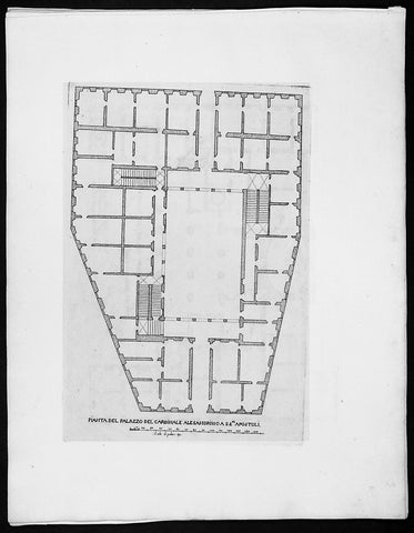
1665 De Rossi Original Antique Architectural Plan, Print of Palazzo Valentini Rome, Italy
- Title : Pianta Del Palazzo Del Cardinale Alesandrino a SS Apostoli
- Date : 1665
- Condition: (A+) Fine Condition
- Ref: 91183
- Size: 18in x 14in (460mm x 360mm)
Description:
This finely engraved original antique architectural engraving a plan of Palazzo Valentini in central Rome, Italy by Giovanni Battistaa Falda was published by Giacomo de Rossi in the 1665 edition of Il nuovo teatro delle fabriche, et edificii, in prospettiva di Roma moderna, 1665-1699.
These original prints are published on beautiful heavy clean original 17th century laid Italian made paper inlaid with a Fleur-de-Lis watermark.
Palazzo Valentini is a palazzo in central Rome, Italy, not far from Piazza Venezia that was the residence of Carlo Michele Bonelli, Cardinal Alessandrino and his hiers in the 17th century.
The palazzo was first built by cardinal Michele Bonelli, nephew of pope Pius V, who, in 1585, acquired a pre-existing palazzo from Giacomo Boncompagni at the extremity of what was then piazza dei Santi Apostoli. Today the palazzo is separated from that piazza by via Quattro Novembre, opened later to connect the new via Nazionale with piazza Venezia. The cardinal was also the owner of a large part of the area which extended, behind the palazzo, above the ruins of the imperial foraof Trajan and Augustus, known by the name "Pantano" due to being subject to impaludamenti or flooding. Over the same years the district on the ruins of the imperial fora was subjected to a general development of the land and to a systematic urbanisation, with the creation of the "quartiere Alessandrino" in the cardinal's honour (he was nicknamed "cardinale alessandrino" after his origins in a village in the province of Alessandria). The quarter was destroyed in the 1920s and 1930s to open via dei Fori Imperiali.
The trapezoidal plan of the palazzo was designed by Domenico Paganelli. Thanks to substantial funds ploughed into the project by the cardinal, the palazzo was quickly completed within 3 years after building started. In the 17th century the building was then subject to a series of major renovations and expansions, carried out on behalf of cardinals Carlo Bonelli and Michele Ferdinando Bonelli. The palazzo was partially demolished and rebuilt by Francesco Peparelli for its new owner, cardinal Renato Imperiali, who organised the important family library (the "Imperiali") of around 24,000 volumes.
At the start of the 18th century, the palazzo was leased to several prominent personalities, including marchese Francesco Maria Ruspoli from 1705 to 1713, who made it the site for a private theatre and hosted illustrious musicians of the time such as Handel, Alessandro Scarlatti and Arcangelo Corelli. The entire building was then acquired in 1752 by cardinal Giuseppe Spinelli, who realised a new decorative scheme for the first floor and systematised the library (meant by him for public use, and frequented by Johann Joachim Winckelmann) on the ground floor.
In 1827 the Prussian banker and consul general Vincenzo Valentini acquired the palazzo, in which he settled and to which he gave his name. The palazzo was later expanded and rebuilt at great expense, and its new owner used it to house his own collection of paintings as well as increasing the palazzo's own substantial library and archaeological collection. Completion of the works at the back of the palazzo, overlooking the column of Trajan, was entrusted to the architects Filippo Navone and Giovanni Battista Benedetti. Between 1861 and 1865 Vincenzo's son Gioacchino Valentini commissioned two further expansions on the left side, along via di Sant'Eufemia, designed by the architect Luigi Gabet. The provincial deputation of Rome acquired the palazzo as their base in 1873, commissioning the architect Gabet to complete the right side on via de’ Fornari, at the top of vicolo di San Bernardo.
General Definitions:
Paper thickness and quality: - Heavy and stable
Paper color : - off white
Age of map color: -
Colors used: -
General color appearance: -
Paper size: - 18in x 14in (460mm x 360mm)
Plate size: - 11 1/2in x 9in (290mm x 230mm)
Margins: - Min 1/2in (12mm)
Imperfections:
Margins: - None
Plate area: - None
Verso: - None
Background:
Il Nuovo Teatro: One of the most important architectural projects of the seventeenth century was the urban renovation of Rome. Under the brilliant leadership of Pope Alessandro VII (1655-1667), Rome dramatically emerged as one of the most modern and beautiful cities of the new Baroque age. Within several decades spacious roadways were constructed, monumental buildings arose, and many public squares appeared with elaborate fountains and monuments. To be sure, this massive undertaking was meant to underline the absolute power of the Papacy but it also brought forth a new flowering of Italian art and architecture.
The Nuovo Teatro was initiated in 1665 to depict the new Rome in a series of etchings. What it gave to future generations was a magnificent historical record of views etched by two of Italy's greatest architectural artists. The printing and publishing of these important etchings was entrusted to Giacomo de Rossi (1626-1691), the head of the most dominant Roman publishing house. Sons and nephews of de Rossi, in fact, continued the publishing house until 1738 when the business was sold to Pope Clement XII to form the basis of the Regia Calcografia.) Altogether, four sets of Nuovo Teatro were created during the seventeenth century. Volumes one (35 etchings) and two (17 etchings) were both published in the year of 1665 and dealt mainly in views of the new piazzas, gardens, terraces and their surrounding buildings. Volume 3 (38 etchings) was published in 1669 and concentrated upon the newly constructed churches of Rome. Every plate from the first three sets was both designed and etched by the influential architectural artist, Giovanni Battista Falda (1643-1678). For reasons unknown the fourth and final volume (52 etchings) did not appear until 1699. It was published by Giacomo's successor, Domenico de Rossi, and featured views of the palaces and stately homes of Rome. Each plate was designed and etched by the famous architect and etcher, Alessandro Specchi (1668-1729)
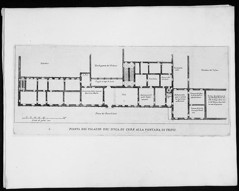
1665 De Rossi Original Antique Architectural Plan, Print of Poli Palace, Trevi Rome, Italy
- Title : Pianta Del Palazzo Del Duca Di Cere Alla Fontana Di Trevi
- Date : 1665
- Condition: (A+) Fine Condition
- Ref: 91179
- Size: 18in x 14in (460mm x 360mm)
Description:
This finely engraved original 1665 antique architectural plan of the Palace of the Dukes of Poli fronting the great Trevi Fountain located in Rome, Italy by Giovanni Battistaa Falda, was published by Giacomo de Rossi in the 1665 edition of Il nuovo teatro delle fabriche, et edificii, in prospettiva di Roma modernapublished between 1665-1699.
These original prints are published on beautiful heavy clean original 17th century laid Italian made paper.
The Palazzo Poli is a palace in Rome, Italy, forming the backdrop to the famous Trevi Fountain. Luigi Vanvitelli gave it a monumental facade as a setting for the fountain. It was there that Princess Zinaida Volkonskaya threw her lavish parties in the 1830s. The central portion of the palace was demolished to provide room for the large fountain in 1730.[1] The Palazzo Poli houses an important collection of copper engraving plates from the 16th century to the present.[2] The Palazzo also houses the Istituto Nazionale per la Grafica.
General Definitions:
Paper thickness and quality: - Heavy and stable
Paper color : - off white
Age of map color: -
Colors used: -
General color appearance: -
Paper size: - 18in x 14in (460mm x 360mm)
Plate size: - 11 1/2in x 9in (290mm x 230mm)
Margins: - Min 1/2in (12mm)
Imperfections:
Margins: - None
Plate area: - None
Verso: - None
Background:
Il Nuovo Teatro: One of the most important architectural projects of the seventeenth century was the urban renovation of Rome. Under the brilliant leadership of Pope Alessandro VII (1655-1667), Rome dramatically emerged as one of the most modern and beautiful cities of the new Baroque age. Within several decades spacious roadways were constructed, monumental buildings arose, and many public squares appeared with elaborate fountains and monuments. To be sure, this massive undertaking was meant to underline the absolute power of the Papacy but it also brought forth a new flowering of Italian art and architecture.
The Nuovo Teatro was initiated in 1665 to depict the new Rome in a series of etchings. What it gave to future generations was a magnificent historical record of views etched by two of Italy's greatest architectural artists. The printing and publishing of these important etchings was entrusted to Giacomo de Rossi (1626-1691), the head of the most dominant Roman publishing house. Sons and nephews of de Rossi, in fact, continued the publishing house until 1738 when the business was sold to Pope Clement XII to form the basis of the Regia Calcografia.) Altogether, four sets of Nuovo Teatro were created during the seventeenth century. Volumes one (35 etchings) and two (17 etchings) were both published in the year of 1665 and dealt mainly in views of the new piazzas, gardens, terraces and their surrounding buildings. Volume 3 (38 etchings) was published in 1669 and concentrated upon the newly constructed churches of Rome. Every plate from the first three sets was both designed and etched by the influential architectural artist, Giovanni Battista Falda (1643-1678). For reasons unknown the fourth and final volume (52 etchings) did not appear until 1699. It was published by Giacomo's successor, Domenico de Rossi, and featured views of the palaces and stately homes of Rome. Each plate was designed and etched by the famous architect and etcher, Alessandro Specchi (1668-1729)
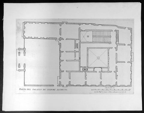
1665 De Rossi Original Antique Architectural Plan, Print of Sachetti Palace Rome, Italy
- Title : Pianta Del Palazzo De Signori Sachetti
- Date : 1665
- Condition: (A+) Fine Condition
- Ref: 91191
- Size: 18in x 14in (460mm x 360mm)
Description:
This finely engraved original 1665 antique architectural print of the Sachetti Palace in Rome, Italy by Giovanni Battista Falda was published by Giacomo de Rossi in the 1665 edition of Il nuovo teatro delle fabriche, et edificii, in prospettiva di Roma moderna, 1665-1699.
These original prints are published on beautiful heavy clean original 17th century laid Italian made paper.
Sacchetti palace is located in Via Giulia in Rome.
Its construction was carried out by Antonio da Sangallo , who wanted to make his own home, obtaining in 1542 the land and a pre-existing unfinished house owned by the Vatican Chapter III , his principal, if not exclusive, client, to whom he dedicated The coat of arms still existing but rubbed on the main facade. At the building, the architect, who used to call the "perfect palace", spent the last years of his life especially for design until 1545 ; When he died in 1546, he went to his son Horace, and the construction was completed by Nanni of Baccio Bigio .Acquired by the Ricci di Montepulciano, who took large sums for extensions and decorative works, he later passed to the Cevoli or Ceuli family, from which he took the adjoining Alley of Cefalo; In 1608 it was bought by Cardinal Ottavio Acquaviva d'Aragona Archbishop of Napleswho before 1612, the year of his death, built the chapel frescoed by Agostino Ciampelli . In 1648 Acquaviva sold the palace to the Sacchettimarquis from Florence , who owned it in full until 2015 when part of it was sold to other owners.
The palace houses some of the most significant cycles of Mannerism , with works byFrancesco Salviati , to which the splendid frescoes of the Audience Hall (1553-1555) Pietro da Cortona andJacopino del Conte are to be found . Palazzo Sacchetti is used for the film The Great Beauty : "Viola, the rich and depressed friend, lives alone with her psychopathic son at Palazzo Sacchetti , in via Giulia, where she organizes a lunch where no one will be present
General Definitions:
Paper thickness and quality: - Heavy and stable
Paper color : - off white
Age of map color: -
Colors used: -
General color appearance: -
Paper size: - 18in x 14in (460mm x 360mm)
Plate size: - 11 1/2in x 9in (290mm x 230mm)
Margins: - Min 1/2in (12mm)
Imperfections:
Margins: - None
Plate area: - None
Verso: - None
Background:
Il Nuovo Teatro: One of the most important architectural projects of the seventeenth century was the urban renovation of Rome. Under the brilliant leadership of Pope Alessandro VII (1655-1667), Rome dramatically emerged as one of the most modern and beautiful cities of the new Baroque age. Within several decades spacious roadways were constructed, monumental buildings arose, and many public squares appeared with elaborate fountains and monuments. To be sure, this massive undertaking was meant to underline the absolute power of the Papacy but it also brought forth a new flowering of Italian art and architecture.
The Nuovo Teatro was initiated in 1665 to depict the new Rome in a series of etchings. What it gave to future generations was a magnificent historical record of views etched by two of Italy's greatest architectural artists. The printing and publishing of these important etchings was entrusted to Giacomo de Rossi (1626-1691), the head of the most dominant Roman publishing house. Sons and nephews of de Rossi, in fact, continued the publishing house until 1738 when the business was sold to Pope Clement XII to form the basis of the Regia Calcografia.) Altogether, four sets of Nuovo Teatro were created during the seventeenth century. Volumes one (35 etchings) and two (17 etchings) were both published in the year of 1665 and dealt mainly in views of the new piazzas, gardens, terraces and their surrounding buildings. Volume 3 (38 etchings) was published in 1669 and concentrated upon the newly constructed churches of Rome. Every plate from the first three sets was both designed and etched by the influential architectural artist, Giovanni Battista Falda (1643-1678). For reasons unknown the fourth and final volume (52 etchings) did not appear until 1699. It was published by Giacomo's successor, Domenico de Rossi, and featured views of the palaces and stately homes of Rome. Each plate was designed and etched by the famous architect and etcher, Alessandro Specchi (1668-1729)
1665 De Rossi Original Antique Architectural Plan, Print of Santo Spirito Palace Florence
- Title : Pianta Del Palazzo Di Santo Spirito
- Date : 1665
- Condition: (A+) Fine Condition
- Ref: 91193
- Size: 18in x 14in (460mm x 360mm)
Description:
This finely engraved original antique architectural print of Palace Santo Spirito in the Oltrarno quarter of Florence, Italy by Giovanni Battistaa Falda was published by Giacomo de Rossi in the 1665 edition of Il nuovo teatro delle fabriche, et edificii, in prospettiva di Roma moderna, 1665-1699.
These original prints are published on beautiful heavy clean original 17th century laid Italian made paper.
General Definitions:
Paper thickness and quality: - Heavy and stable
Paper color : - off white
Age of map color: -
Colors used: -
General color appearance: -
Paper size: - 18in x 14in (460mm x 360mm)
Plate size: - 11 1/2in x 9in (290mm x 230mm)
Margins: - Min 1/2in (12mm)
Imperfections:
Margins: - None
Plate area: - None
Verso: - None
Background:
Il Nuovo Teatro: One of the most important architectural projects of the seventeenth century was the urban renovation of Rome. Under the brilliant leadership of Pope Alessandro VII (1655-1667), Rome dramatically emerged as one of the most modern and beautiful cities of the new Baroque age. Within several decades spacious roadways were constructed, monumental buildings arose, and many public squares appeared with elaborate fountains and monuments. To be sure, this massive undertaking was meant to underline the absolute power of the Papacy but it also brought forth a new flowering of Italian art and architecture.
The Nuovo Teatro was initiated in 1665 to depict the new Rome in a series of etchings. What it gave to future generations was a magnificent historical record of views etched by two of Italy's greatest architectural artists. The printing and publishing of these important etchings was entrusted to Giacomo de Rossi (1626-1691), the head of the most dominant Roman publishing house. Sons and nephews of de Rossi, in fact, continued the publishing house until 1738 when the business was sold to Pope Clement XII to form the basis of the Regia Calcografia.) Altogether, four sets of Nuovo Teatro were created during the seventeenth century. Volumes one (35 etchings) and two (17 etchings) were both published in the year of 1665 and dealt mainly in views of the new piazzas, gardens, terraces and their surrounding buildings. Volume 3 (38 etchings) was published in 1669 and concentrated upon the newly constructed churches of Rome. Every plate from the first three sets was both designed and etched by the influential architectural artist, Giovanni Battista Falda (1643-1678). For reasons unknown the fourth and final volume (52 etchings) did not appear until 1699. It was published by Giacomo's successor, Domenico de Rossi, and featured views of the palaces and stately homes of Rome. Each plate was designed and etched by the famous architect and etcher, Alessandro Specchi (1668-1729)
1665 De Rossi Original Antique Architectural Plan, Print of Silvestri Palace Milan, Italy
- Title : Pianta Del Palazzo Dell Sig Marchese Silvestri
- Date : 1665
- Condition: (A+) Fine Condition
- Ref: 91190
- Size: 18in x 14in (460mm x 360mm)
Description:
This finely engraved original antique architectural print of the Casa Fontana Silvestri Palace in Milan, Italy by Giovanni Battistaa Falda was published by Giacomo de Rossi in the 1665 edition of Il nuovo teatro delle fabriche, et edificii, in prospettiva di Roma moderna, 1665-1699.
These original prints are published on beautiful heavy clean original 17th century laid Italian made paper.
Casa Fontana-Silvestri is one of the few Renaissance buildings surviving in Milan, Italy. The main structure dates back to the 12th century, but its current form is due to a thorough modification that were made at the end of the 14th century, in a style that mixes Renaissance and Gothic elements.
The facade was originally decorated with frescos that scholars credit to Bramante or Bramantino; most of these painting have disappeared, with just a few remnants now visible under the cornice. It has also been suggested that Bramante may have designed the cotto decorations, also on the facade.
General Definitions:
Paper thickness and quality: - Heavy and stable
Paper color : - off white
Age of map color: -
Colors used: -
General color appearance: -
Paper size: - 18in x 14in (460mm x 360mm)
Plate size: - 11 1/2in x 9in (290mm x 230mm)
Margins: - Min 1/2in (12mm)
Imperfections:
Margins: - None
Plate area: - None
Verso: - None
Background:
Il Nuovo Teatro: One of the most important architectural projects of the seventeenth century was the urban renovation of Rome. Under the brilliant leadership of Pope Alessandro VII (1655-1667), Rome dramatically emerged as one of the most modern and beautiful cities of the new Baroque age. Within several decades spacious roadways were constructed, monumental buildings arose, and many public squares appeared with elaborate fountains and monuments. To be sure, this massive undertaking was meant to underline the absolute power of the Papacy but it also brought forth a new flowering of Italian art and architecture.
The Nuovo Teatro was initiated in 1665 to depict the new Rome in a series of etchings. What it gave to future generations was a magnificent historical record of views etched by two of Italy's greatest architectural artists. The printing and publishing of these important etchings was entrusted to Giacomo de Rossi (1626-1691), the head of the most dominant Roman publishing house. Sons and nephews of de Rossi, in fact, continued the publishing house until 1738 when the business was sold to Pope Clement XII to form the basis of the Regia Calcografia.) Altogether, four sets of Nuovo Teatro were created during the seventeenth century. Volumes one (35 etchings) and two (17 etchings) were both published in the year of 1665 and dealt mainly in views of the new piazzas, gardens, terraces and their surrounding buildings. Volume 3 (38 etchings) was published in 1669 and concentrated upon the newly constructed churches of Rome. Every plate from the first three sets was both designed and etched by the influential architectural artist, Giovanni Battista Falda (1643-1678). For reasons unknown the fourth and final volume (52 etchings) did not appear until 1699. It was published by Giacomo's successor, Domenico de Rossi, and featured views of the palaces and stately homes of Rome. Each plate was designed and etched by the famous architect and etcher, Alessandro Specchi (1668-1729)
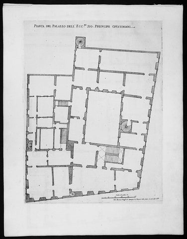
1665 De Rossi Original Antique Architectural Plan, Print of the Giustiniani Palace in Venice, Italy
- Title : Pianta Del Palazzo Dell Ecc. Sig. Prencipe Giustiniani
- Date : 1665
- Condition: (A+) Fine Condition
- Ref: 91188
- Size: 18in x 14in (460mm x 360mm)
Description:
This finely engraved original 1665 antique architectural print of the Giustiniani Palace in Venice, Italy by Giovanni Battistaa Falda was published by Giacomo de Rossi in the 1665 edition of Il nuovo teatro delle fabriche, et edificii, in prospettiva di Roma moderna, 1665-1699.
These original prints are published on beautiful heavy clean original 17th century laid Italian made paper inlaid with a Fleur-de-Lis watermark.
Palazzo Giustinian is a palace in Venice, northern Italy, situated in the Dorsoduro district and overlooking the Grand Canal next to Ca' Foscari. It is among the best examples of the late Venetian Gothic and was the final residence of Princess Louise Marie Thérèse of France.
The edifice was built in the late 15th century, perhaps with the participation of Bartolomeo Bon. The palace consisted originally of two separated sectors, one for each branch of the family, which were later harmonized through a central section in the façade; these are known as Ca' Giustinian dei Vescovi(now housing part of the Ca' Foscari University) and Ca' Giustinian dalle Zogie (now privately owned). Behind the façade, they are separated by an alley which, through a sottoportego, or portico-tunnel, connects to the central portal.
The two sub-palaces share numerous decorative features with the annexed Ca' Foscari. They have an L-shaped plan with four floors, the upper ones having mullioned windows. At the piano nobile they form a six-arches arcade with an interwoven motif of multi-lobes circles. The single windows are ogival, or decorated with a three-lobe motif. Ca' Giustinian dei Vescovi has in the rear a court with a Gothic staircase, while Ca' Giustinian delle Zogie has a large garden.
The family sold the palazzo in the 19th century. Since then, personalities such as painter Natale Schiavoni, German composer Richard Wagner (who wrote the second act of Tristan und Isolde here between 1858 and 1859), the last Duchess of Parma, Louise d'Artois, and Hungarian violinist Franz von Vecsey have lived here
General Definitions:
Paper thickness and quality: - Heavy and stable
Paper color : - off white
Age of map color: -
Colors used: -
General color appearance: -
Paper size: - 18in x 14in (460mm x 360mm)
Plate size: - 11 1/2in x 9in (290mm x 230mm)
Margins: - Min 1/2in (12mm)
Imperfections:
Margins: - None
Plate area: - None
Verso: - None
Background:
Il Nuovo Teatro: One of the most important architectural projects of the seventeenth century was the urban renovation of Rome. Under the brilliant leadership of Pope Alessandro VII (1655-1667), Rome dramatically emerged as one of the most modern and beautiful cities of the new Baroque age. Within several decades spacious roadways were constructed, monumental buildings arose, and many public squares appeared with elaborate fountains and monuments. To be sure, this massive undertaking was meant to underline the absolute power of the Papacy but it also brought forth a new flowering of Italian art and architecture.
The Nuovo Teatro was initiated in 1665 to depict the new Rome in a series of etchings. What it gave to future generations was a magnificent historical record of views etched by two of Italy's greatest architectural artists. The printing and publishing of these important etchings was entrusted to Giacomo de Rossi (1626-1691), the head of the most dominant Roman publishing house. Sons and nephews of de Rossi, in fact, continued the publishing house until 1738 when the business was sold to Pope Clement XII to form the basis of the Regia Calcografia.) Altogether, four sets of Nuovo Teatro were created during the seventeenth century. Volumes one (35 etchings) and two (17 etchings) were both published in the year of 1665 and dealt mainly in views of the new piazzas, gardens, terraces and their surrounding buildings. Volume 3 (38 etchings) was published in 1669 and concentrated upon the newly constructed churches of Rome. Every plate from the first three sets was both designed and etched by the influential architectural artist, Giovanni Battista Falda (1643-1678). For reasons unknown the fourth and final volume (52 etchings) did not appear until 1699. It was published by Giacomo's successor, Domenico de Rossi, and featured views of the palaces and stately homes of Rome. Each plate was designed and etched by the famous architect and etcher, Alessandro Specchi (1668-1729)
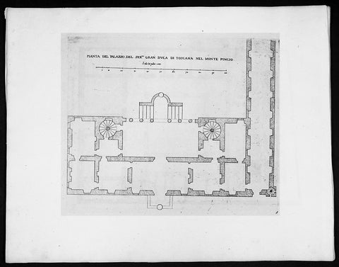
1665 De Rossi Original Antique Architectural Plan, Print of Villa Medici Monte Pincio Italy Rome
- Title : Pianta Del Palazzo Del sermo gran Duca Di Toscana nel monte Pincio
- Date : 1665
- Condition: (A+) Fine Condition
- Ref: 91180
- Size: 18in x 14in (460mm x 360mm)
Description:
This finely engraved original 1655 antique architectural engraving a plan part of the Villa Medici on the Pincian Hill founded by Ferdinando I de' Medici, Grand Duke of Tuscany in Rome, Italy by Giovanni Battistaa Falda was published by Giacomo de Rossi in the 1665 edition of Il nuovo teatro delle fabriche, et edificii, in prospettiva di Roma moderna, 1665-1699.
These original prints are published on beautiful heavy clean original 17th century laid Italian made paper.
The Villa Medici is a mannerist villa and an architectural complex with a garden contiguous with the larger Borghese gardens, on the Pincian Hill next to Trinità dei Monti in Rome, Italy. The Villa Medici, founded by Ferdinando I de' Medici, Grand Duke of Tuscany and now property of the French State has housed the French Academy in Rome since 1803. In ancient times, the site of the Villa Medici was part of the gardens of Lucullus, which passed into the hands of the Imperial family with Messalina, who was murdered in the villa.
In 1564, when the nephews of Cardinal Giovanni Ricci of Montepulciano acquired the property, it had long been abandoned to viticulture. The sole dwelling was the Casina of Cardinale Marcello Crescenzi, who had maintained a vineyard here and had begun improvements to the villa under the direction of the Florentine Nanni Lippi, who had died however, before work had proceeded far. The new proprietors commissioned Annibale Lippi, the late architect's son, to continue work. Interventions by Michelangelo are a tradition.
In 1576, the property was acquired by Cardinal Ferdinando de' Medici, who finished the structure to designs by Bartolomeo Ammanati. The Villa Medici became at once the first among Medici properties in Rome, intended to give concrete expression to the ascendancy of the Medici among Italian princes and assert their permanent presence in Rome. Under the Cardinal's insistence, Ammanati incorporated into the design Roman bas-reliefs and statues that were coming to sight with almost every spadeful of earth, with the result that the facades of the Villa Medici, as it now was, became a virtual open-air museum. A series of grand gardens recalled the botanical gardens created at Pisa and at Florence by the Cardinal's father Cosimo I de' Medici, sheltered in plantations of pines, cypresses and oaks. Ferdinando de' Medici had a studiolo, a retreat for study and contemplation, built to the north east of the garden above the Aurelian wall. Now these rooms look onto Borghese gardens but would then have had views over the Roman countryside. These two rooms were only uncovered in 1985 by the restorer Geraldine Albers: the concealing whitewash had protected and conserved the superb fresco decoration carried out by Jacopo Zucchi 1576 and 1577.
Among the striking assemblage of Roman sculptures in the villa were some one hundred seventy pieces bought from two Roman collections that had come together through marriage, the Capranica and the della Valle collections. An engraving detailing the arrangement of statues prior to 1562 was documented by Galassi Alghisi. Three works that arrived at the Villa Medici under Cardinal Fernando, ranked with the most famous in the city: the Niobe Group and the Wrestlers, both discovered in 1583 and immediately purchased by Cardinal Ferdinando, and the Arrotino. When the Cardinal succeeded as Grand Duke of Tuscany in 1587, his elder brother having died, he satisfied himself with plaster copies of his Niobe Group, in full knowledge of the prestige that accrued to the Medici by keeping such a magnificent collection in the European city whose significance far surpassed that of their own capital. The Medici lions were completed in 1598, and the Medici Vase entered the collection at the Villa, followed by the Venus de' Medici by the 1630s; the Medici sculptures were not removed to Florence until the eighteenth century. Then the antiquities from the Villa Medici formed the nucleus of the collection of antiquities in the Uffizi, and Florence began to figure on the European Grand Tour.
The fountain in the front of the Villa Medici is formed from a red granite vase from ancient Rome. It was designed by Annibale Lippi in 1589. The view from the Villa looking over the fountain towards St Peter's in the distance has been much painted, but the trees in the foreground have now obscured the view.
Like the Villa Borghese that adjoins them, the villa's gardens were far more accessible than the formal palaces such as Palazzo Farnese in the heart of the city. For a century and a half the Villa Medici was one of the most elegant and worldly settings in Rome, the seat of the Grand Dukes' embassy to the Holy See. When the male line of the Medici died out in 1737, the villa passed to the house of Lorraine and, briefly in Napoleonic times, to the Kingdom of Etruria. In this manner Napoleon Bonaparte came into possession of the Villa Medici, which he transferred to the French Academy at Rome.
General Definitions:
Paper thickness and quality: - Heavy and stable
Paper color : - off white
Age of map color: -
Colors used: -
General color appearance: -
Paper size: - 18in x 14in (460mm x 360mm)
Plate size: - 11 1/2in x 9in (290mm x 230mm)
Margins: - Min 1/2in (12mm)
Imperfections:
Margins: - None
Plate area: - None
Verso: - None
Background:
Il Nuovo Teatro: One of the most important architectural projects of the seventeenth century was the urban renovation of Rome. Under the brilliant leadership of Pope Alessandro VII (1655-1667), Rome dramatically emerged as one of the most modern and beautiful cities of the new Baroque age. Within several decades spacious roadways were constructed, monumental buildings arose, and many public squares appeared with elaborate fountains and monuments. To be sure, this massive undertaking was meant to underline the absolute power of the Papacy but it also brought forth a new flowering of Italian art and architecture.
The Nuovo Teatro was initiated in 1665 to depict the new Rome in a series of etchings. What it gave to future generations was a magnificent historical record of views etched by two of Italy's greatest architectural artists. The printing and publishing of these important etchings was entrusted to Giacomo de Rossi (1626-1691), the head of the most dominant Roman publishing house. Sons and nephews of de Rossi, in fact, continued the publishing house until 1738 when the business was sold to Pope Clement XII to form the basis of the Regia Calcografia.) Altogether, four sets of Nuovo Teatro were created during the seventeenth century. Volumes one (35 etchings) and two (17 etchings) were both published in the year of 1665 and dealt mainly in views of the new piazzas, gardens, terraces and their surrounding buildings. Volume 3 (38 etchings) was published in 1669 and concentrated upon the newly constructed churches of Rome. Every plate from the first three sets was both designed and etched by the influential architectural artist, Giovanni Battista Falda (1643-1678). For reasons unknown the fourth and final volume (52 etchings) did not appear until 1699. It was published by Giacomo's successor, Domenico de Rossi, and featured views of the palaces and stately homes of Rome. Each plate was designed and etched by the famous architect and etcher, Alessandro Specchi (1668-1729)
1665 Johan Nieuhof Large Antique Print of Chinese Mounted Cavalry, Archery
Antique Map
- Title : Kryghs-Ordre in Het Marseren; L Ordre de la Cavallerie en Marchant
- Ref #: 17056
- Size: 15in x 12 1/2in (380mm x 310mm)
- Date : 1665
- Condition: (A+) Fine Condition
Description:
This original copper-plate engraved antique print of Chinese Mounted Cavalry in formation by Johan Nieuhof was published by Jacob van Meurs in the 1665 edition of L’Ambassade de la Compagnie Orientale des Provinces Unies vers l’Empereur de la Chine, ou Grand Cam de Tartarie, faite par les sieurs Pierre de Goyer et Jacob de Keyser illustrée d’une très-exacte description des villes, bourgs, villages, ports de mer et autres lieux plus considérables de la Chine....1665. Title in English: An embassy from the East-India Company (1669).
General Definitions:
Paper thickness and quality: - Heavy and stable
Paper color : - off white
Age of map color: -
Colors used: -
General color appearance: -
Paper size: - 15in x 12 1/2in (380mm x 310mm)
Plate size: - 12 1/2in x 7 1/2in (310mm x 195mm)
Margins: - Min 1in (25mm)
Imperfections:
Margins: - None
Plate area: - None
Verso: - None
Background:
The vast, immediate success of the book which was published in Johan Nieuhof's name in 1665 in Dutch language was every publisher's dream. In this time and age, his report on his journey to China, compiled of the material he had sent to his brother, was a bestseller! In the 17th century alone, six Dutch editions were published. Within the same year of its release it was translated to French – the very same edition we have here – and shortly after it was also translated to German, Latin and English.
This huge interest in the book by the global public was not by chance! At the time, China was the dream country of every merchant and especially of every investor in Europe. China had the goods European markets were longing for. Firstly there was tea, but also the incredibly modern porcelain and the wonderfully soft silk. In addition, the spices and remedies from the Chinese market were promising great profit!
Since individual people of the 17th century could not finance successful trading companies of this size any longer, ambitious men had cooperated with the government and founded trading companies due to royal privileges. One can imagine a sort of incorporated company whose capital was provided by a market of investors. These resources were used to fit out fleets, establish local strongpoints and pay permanent employees whose work should bring investors great profit on their deposits.
The area called East India at the time was particularly popular for such investments. This wasn't just India and the Spice Islands, but also China and Japan. In 1600 the British founded their East India Company. In 1602 the Dutch East India Company followed, and Johan Nieuhof was allowed to accompany the imperial embassy. But other countries wanted to participate in the trade, too and founded companies: Denmark, Sweden, Portugal – and also France in 1665. Louis XIV had first privileged an East India Company on the initiative of his minister of finance Colbert, which competed for funds in 1665. Therefore Nieuhof's book was just in time!
What made Nieuhof's report especially interesting, were the 150 copper engravings that carried the reader off into the exotic worlds of the Far East. Nieuhof's book thus started the China-trend. There could be no rococo castle without a porcelain cabinet. No bourgeois household without chinoiseries. But Johan Nieuhof did not know which goods were desired by China in exchange. Consequently tea and silk had to be paid with silver. The negative trade balance was troubling to all European governments until the English had the delinquent idea to import opium on a large scale. It was only then that the trade balance turned around. But surely Johan Nieuhof cannot be made responsible for this.
Nieuhof, Johan (1618 – 1672)
Nieuhof was a Dutch traveler who wrote about his journeys to Brazil, China and India. The most famous of these was a trip of 2,400 kilometers from Canton to Peking in 1655-1657, which enabled him to become an authoritative Western writer on China. He wrote An embassy from the East-India Company containing the written account of this journey.
Johan Nieuhof was born in Uelsen, a town in the county of Bentheim, Lower Saxony, sitting just across the Dutch-German border. His father (originally from Zwolle) was mayor of the town, and was later succeeded by one of Johans brothers and brother-in-law. By the grace of Cornelis Jan Witsen, a leading figure within the Dutch West India Company (or WIC), Nieuhof left for Dutch Brazil in 1640 as a reserve officer-candidate. From then on, barring two short family visits in 1658 and 1671, he spent all the rest of his life abroad.
Nieuhof was employed in Brazil to explore the regions between Maranhão and the São Francisco Rivers, made a particular study of the neighborhood of Pernambuco. He left Brazil in 1649, after the Portuguese victory in the Second Battle of Guararapes. Upon his return, Nieuhof joined the service of the Dutch East India Company (or VOC). In service of the VOC he resided several years in Batavia, and then was appointed in 1654 steward of an embassy to the relatively new Qing emperor China under Peter de Goyer and Jacob de Keyser, which aimed to gain trading rights on Chinas southern coast.
He remained in China until 1657. In 1663 he operated as an ambassador in Quilon, after the occupation of the Malabar Coast by Rijckloff van Goens. During this period he visited several chiefs of indigenous tribes in order to secure trade relations with them. Afterwards, he was offered a post on Ceylon where he was stationed between 1663 and 1667. He was imprisoned for seven months because of illegal trade in pearls. Nieuhof was sent to Batavia by Hendrik van Rheede and fired by the Dutch East India Company.
On returning to the Indies from a trip home in 1672, he stopped on the isle of Madagascar. On October 8 1672, Nieuhof traveled inland along with the first mate, in search of the local tribes in order to trade with them, as well as secure water for his crew. Upon hearing several gunshots, the captain sent a second ship towards the island in order to await Nieuhofs return. After three days of waiting, the captain presumed Nieuhof and his company to be murdered and sailed onwards towards Mauritius. On order of the governing council in Amsterdam, a ship was sent from the Cape of Good Hope to retrieve Nieuhof and his fellows, but no trace of them could be found.
In the first half of the 17th century, the VOC tried to break the Portuguese monopoly position on trade to Macau. When they did not succeed, they sent six embassies to Peking between 1655 and 1685. Their aim was to convince the Qing emperor to open up trade relations on the southern coast, in favor of the VOC, although they ultimately failed. Nieuhof was appointed to the position of steward on one of these embassies by Joan Maetsuycker, which traveled from Canton to Peking between 1655 and 1658. They were the second embassy to try and gain the emperors favor, the first was led by Zacharias Wagenaer. Nieuhofs duties as part of the embassy primarily consisted of ceremonial matters as well as securing lodgings. He was, however, specifically appointed to illustrate any and all of the cities, palaces, temples, rivers and other noteworthy buildings in their true to nature form.
On March 17 1656, after months of negotiations and discussions of tributes to be paid to the Chinese emperor and viceroy, the embassy left Canton by barge, to travel towards Peking. The embassy arrived at the emperors court in Peking on July 18 the same year. The hired the jesuit scholar Johann Adam Schall von Bell to be their translator, who warned them of the possible dangers and required ceremonies to approach the emperor. On September 24, the embassy was received by the Shunzhi Emperor. As dictated by their translator, the party performed the traditional kowtow, as failing to do so would most likely result in immediate refusal by the emperor. As a result, the emperor allowed Dutch embassies to visit the court once every eight years, in parties consisting of no more than 100 men. Any trading rights were not discussed nor granted at this point. On October 16 the embassy was asked to leave the city of Peking within two hours. Their return trip took three months; putting the entire length of the embassy at 20 months and 6 days.
At his homecoming in 1658, he had entrusted his notes and annotations to his brother Hendrik, whom Johan thanked when finally (in 1665) Hendrik produced an ample study of China, with many images, text and explanation of the latest events. The work was published by Jacob van Meurs in 1665, titled Het Gezandtschap der Neêrlandtsche Oost-Indische Compagnie, aan den grooten Tartarischen Cham, den tegenwoordigen Keizer van China: Waarin de gedenkwaerdigste Geschiedenissen, die onder het reizen door de Sineesche landtschappen, Quantung, Kiangsi, Nanking, Xantung en Peking, en aan het Keizerlijke Hof te Peking, sedert den jaren 1655 tot 1657 zijn voorgevallen, op het bondigste verhandelt worden. Beneffens een Naukeurige Beschrijvinge der Sineesche Steden, Dorpen, Regeering, Weetenschappen, Hantwerken, Zeden, Godsdiensten, Gebouwen, Drachten, Schepen, Bergen, Gewassen, Dieren, et cetera en oorlogen tegen de Tartar : verçiert men over de 150 afbeeltsels, nat leven in Sina getekent. Hendrik dedicated the work to Hendrik Spiegel and Cornelis Jan Witsen (Nicolaes Witsens father), administrators of the East and West India Companies respectively. Translations into French (1665), German (1666), Latin (1668) and English (1669) were also published, each going into at least two editions. More of Nieuhoffs material, on Chinese ships, appeared in Nicolaes Witsens Scheepsbouw (1671).
The reports from these embassies and the reports of the Jesuits formed the only reliable source of information on China available in Western Europe. As mentioned, being the purser of the VOC embassy to Peking, Johan Nieuhof in 1655 had special instructions to observe all farms, towns, palaces, rivers, ... [and other] buildings that he might pass by, drawing them in straight form and figure, as well as remains of the historical victory of the Tartars (Manchus) that brought an end to the reign of the Ming dynasty. The inclusion of approximately 150 illustrations in the book marked the first time that literature on China contained images that were true to nature. In previously published works, belonging to the imaginative fantastic tradition where fact and fiction were hardly discernible, the Chinese were depicted as creatures of fantasy. Nieuhofs illustrations, as opposed to these previous works, depicted the Chinese and their culture as they were observed by the illustrator himself, without fanciful additions.
The 150 illustrations of the Nieuhoffs book were one inspiration for chinoiserie, which became especially popular in the 18th century. Many artists and architects based their designs on the pictures in the book. The original drawings were rediscovered in 1984 in the collection of prince Roland Bonaparte, an anthropologist who collected material about Madagascar, Lapland and the Native Americans.
Publications:
- Johannes Nieuhof (1668), Legatio batavica ad magnum Tartariæ chamum Sungteium, modernum Sinæ imperatorem; Historiarum narratione, quæ legatis in provinciis Quantung, Kiangsi, Nanking, Xantung, Peking, & aula imperatoriâ ab anno 1665 ad annum 1657 obtigerunt ..., Amstelodami: Jacobum Meursium, OCLC 2134985, OL 23411529M
- Het gezantschap der Neêrlandtsche Oost-Indische Compagnie, aan den grooten Tartarischen Cham, den tegenwoordigen keizer van China : waar in de gedenkwaerdighste geschiedenissen, die onder het reizen door de Sineesche landtschappen, Quantung, Kiangsi, Nanking, Xantung en Peking, en aan het keizerlijke hof te Peking, sedert den jare 1655 tot 1657 zijn voorgevallen, op het bondigste verhandelt worden : befeffens een naukeurige Beschryving der Sineesche steden, dorpen, regeering, wetenschappen, hantwerken, zeden, godsdiensten, gebouwen, drachten, schepen, bergen, gewassen, dieren, &c. en oorlogen tegen de Tarters : verçiert men over de 150 afbeeltsels, nat leven in Sina getekent. Amsterdam: Jacob van Meurs, 1665. Title in English: An embassy from the East-India Company (1669).
- Zee- en Lant-Reise door verscheide Gewesten van Oostindien, behelzende veele zeldzaame en wonderlijke voorvallen en geschiedenissen. Beneffens een beschrijving van lantschappen, dieren, gewassen, draghten, zeden en godsdienst der inwoonders: En inzonderheit een wijtloopig verhael der Stad Batavia. Amsterdam: de Weduwe van Jacob van Meurs, 1682. Google books
- Gedenkweerdige Brasiliaense Zee- en Lant-Reise und Zee- en Lant-Reize door verscheide Gewesten van Oostindien. Amsterdam: de Weduwe van Jacob van Meurs, 1682.
1665 Nieuhof Antique Print Imperial Palace Peking or the Forbidden City, Beijing
Antique Map
- Title : Platte Grondt van Skeyers Hof in Pekin; Forme de la Cour Imperiale de Peking
- Ref #: 17055
- Size: 15in x 12 1/2in (380mm x 310mm)
- Date : 1665
- Condition: (A+) Fine Condition
Description:
This original copper-plate engraved antique print a birds-eye view of the Imperial Palace & extensive gardens in Peking, now Beijing, or the Forbidden City by Johan Nieuhof was published by Jacob van Meurs in the 1665 edition of L’Ambassade de la Compagnie Orientale des Provinces Unies vers l’Empereur de la Chine, ou Grand Cam de Tartarie, faite par les sieurs Pierre de Goyer et Jacob de Keyser illustrée d’une très-exacte description des villes, bourgs, villages, ports de mer et autres lieux plus considérables de la Chine....1665. Title in English: An embassy from the East-India Company (1669).
General Definitions:
Paper thickness and quality: - Heavy and stable
Paper color : - off white
Age of map color: -
Colors used: -
General color appearance: -
Paper size: - 15in x 12 1/2in (380mm x 310mm)
Plate size: - 12 1/2in x 7 1/2in (310mm x 195mm)
Margins: - Min 1in (25mm)
Imperfections:
Margins: - None
Plate area: - None
Verso: - None
Background:
The Forbidden City is a palace complex in Dongcheng District, Beijing, China, at the center of the Imperial City of Beijing. It is surrounded by numerous opulent imperial gardens and temples including the 22-hectare Zhongshan Park, the sacrificial Imperial Ancestral Temple, the 69-hectare Beihai Park, and the 23-hectare Jingshan Park.
The Forbidden City was constructed from 1406 to 1420, and was the former Chinese imperial palace and winter residence of the Emperor of China from the Ming dynasty (since the Yongle Emperor) to the end of the Qing dynasty, between 1420 and 1924. The Forbidden City served as the home of Chinese emperors and their households and was the ceremonial and political center of the Chinese government for over 500 years. Since 1925, the Forbidden City has been under the charge of the Palace Museum, whose extensive collection of artwork and artifacts were built upon the imperial collections of the Ming and Qing dynasties. The Forbidden City was declared a World Heritage Site in 1987.
The complex consists of 980 buildings, encompassing 8,886 rooms and covering 720,000 square metres (72 hectares)/178 acres. The palace exemplifies the opulence of the residences of the Chinese emperor and the traditional Chinese palatial architecture, and has influenced cultural and architectural developments in East Asia and elsewhere. It is listed by UNESCO as the largest collection of preserved ancient wooden structures in the world. Since 2012, the Forbidden City has seen an average of 14 million visitors annually, and received more than 19 million visitors in 2019. In 2018, The Forbidden Citys market value has been estimated at US$70 billion, making it both the worlds most valuable palace and the most valuable piece of real estate anywhere in the world.
Some sources describe it as the largest palace in the world still in existence, but other Chinese imperial residences far exceed it in size, namely the 6.1 km2 (610 ha) Zhongnanhai which lies just west of the Forbidden City, the 2.9 km2 (290 ha) Summer Palace in Haidian District, Beijing, and the 5.6 km2 (560 ha) Chengde Mountain Resort in Chengde, Hebei Province.
The Forbidden City in Beijing is one of the largest and most well-preserved ancient wooden structures in the world. It is a national AAAAA-level tourist attraction in China. It was listed as the first batch of national key cultural relics in 1961 and listed as a world cultural heritage in 1987.
Nieuhof, Johan (1618 – 1672)
Nieuhof was a Dutch traveler who wrote about his journeys to Brazil, China and India. The most famous of these was a trip of 2,400 kilometers from Canton to Peking in 1655-1657, which enabled him to become an authoritative Western writer on China. He wrote An embassy from the East-India Company containing the written account of this journey.
Johan Nieuhof was born in Uelsen, a town in the county of Bentheim, Lower Saxony, sitting just across the Dutch-German border. His father (originally from Zwolle) was mayor of the town, and was later succeeded by one of Johans brothers and brother-in-law. By the grace of Cornelis Jan Witsen, a leading figure within the Dutch West India Company (or WIC), Nieuhof left for Dutch Brazil in 1640 as a reserve officer-candidate. From then on, barring two short family visits in 1658 and 1671, he spent all the rest of his life abroad.
Nieuhof was employed in Brazil to explore the regions between Maranhão and the São Francisco Rivers, made a particular study of the neighborhood of Pernambuco. He left Brazil in 1649, after the Portuguese victory in the Second Battle of Guararapes. Upon his return, Nieuhof joined the service of the Dutch East India Company (or VOC). In service of the VOC he resided several years in Batavia, and then was appointed in 1654 steward of an embassy to the relatively new Qing emperor China under Peter de Goyer and Jacob de Keyser, which aimed to gain trading rights on Chinas southern coast.
He remained in China until 1657. In 1663 he operated as an ambassador in Quilon, after the occupation of the Malabar Coast by Rijckloff van Goens. During this period he visited several chiefs of indigenous tribes in order to secure trade relations with them. Afterwards, he was offered a post on Ceylon where he was stationed between 1663 and 1667. He was imprisoned for seven months because of illegal trade in pearls. Nieuhof was sent to Batavia by Hendrik van Rheede and fired by the Dutch East India Company.
On returning to the Indies from a trip home in 1672, he stopped on the isle of Madagascar. On October 8 1672, Nieuhof traveled inland along with the first mate, in search of the local tribes in order to trade with them, as well as secure water for his crew. Upon hearing several gunshots, the captain sent a second ship towards the island in order to await Nieuhofs return. After three days of waiting, the captain presumed Nieuhof and his company to be murdered and sailed onwards towards Mauritius. On order of the governing council in Amsterdam, a ship was sent from the Cape of Good Hope to retrieve Nieuhof and his fellows, but no trace of them could be found.
In the first half of the 17th century, the VOC tried to break the Portuguese monopoly position on trade to Macau. When they did not succeed, they sent six embassies to Peking between 1655 and 1685. Their aim was to convince the Qing emperor to open up trade relations on the southern coast, in favor of the VOC, although they ultimately failed. Nieuhof was appointed to the position of steward on one of these embassies by Joan Maetsuycker, which traveled from Canton to Peking between 1655 and 1658. They were the second embassy to try and gain the emperors favor, the first was led by Zacharias Wagenaer. Nieuhofs duties as part of the embassy primarily consisted of ceremonial matters as well as securing lodgings. He was, however, specifically appointed to illustrate any and all of the cities, palaces, temples, rivers and other noteworthy buildings in their true to nature form.
On March 17 1656, after months of negotiations and discussions of tributes to be paid to the Chinese emperor and viceroy, the embassy left Canton by barge, to travel towards Peking. The embassy arrived at the emperors court in Peking on July 18 the same year. The hired the jesuit scholar Johann Adam Schall von Bell to be their translator, who warned them of the possible dangers and required ceremonies to approach the emperor. On September 24, the embassy was received by the Shunzhi Emperor. As dictated by their translator, the party performed the traditional kowtow, as failing to do so would most likely result in immediate refusal by the emperor. As a result, the emperor allowed Dutch embassies to visit the court once every eight years, in parties consisting of no more than 100 men. Any trading rights were not discussed nor granted at this point. On October 16 the embassy was asked to leave the city of Peking within two hours. Their return trip took three months; putting the entire length of the embassy at 20 months and 6 days.
At his homecoming in 1658, he had entrusted his notes and annotations to his brother Hendrik, whom Johan thanked when finally (in 1665) Hendrik produced an ample study of China, with many images, text and explanation of the latest events. The work was published by Jacob van Meurs in 1665, titled Het Gezandtschap der Neêrlandtsche Oost-Indische Compagnie, aan den grooten Tartarischen Cham, den tegenwoordigen Keizer van China: Waarin de gedenkwaerdigste Geschiedenissen, die onder het reizen door de Sineesche landtschappen, Quantung, Kiangsi, Nanking, Xantung en Peking, en aan het Keizerlijke Hof te Peking, sedert den jaren 1655 tot 1657 zijn voorgevallen, op het bondigste verhandelt worden. Beneffens een Naukeurige Beschrijvinge der Sineesche Steden, Dorpen, Regeering, Weetenschappen, Hantwerken, Zeden, Godsdiensten, Gebouwen, Drachten, Schepen, Bergen, Gewassen, Dieren, et cetera en oorlogen tegen de Tartar : verçiert men over de 150 afbeeltsels, nat leven in Sina getekent. Hendrik dedicated the work to Hendrik Spiegel and Cornelis Jan Witsen (Nicolaes Witsens father), administrators of the East and West India Companies respectively. Translations into French (1665), German (1666), Latin (1668) and English (1669) were also published, each going into at least two editions. More of Nieuhoffs material, on Chinese ships, appeared in Nicolaes Witsens Scheepsbouw (1671).
The reports from these embassies and the reports of the Jesuits formed the only reliable source of information on China available in Western Europe. As mentioned, being the purser of the VOC embassy to Peking, Johan Nieuhof in 1655 had special instructions to observe all farms, towns, palaces, rivers, ... [and other] buildings that he might pass by, drawing them in straight form and figure, as well as remains of the historical victory of the Tartars (Manchus) that brought an end to the reign of the Ming dynasty. The inclusion of approximately 150 illustrations in the book marked the first time that literature on China contained images that were true to nature. In previously published works, belonging to the imaginative fantastic tradition where fact and fiction were hardly discernible, the Chinese were depicted as creatures of fantasy. Nieuhofs illustrations, as opposed to these previous works, depicted the Chinese and their culture as they were observed by the illustrator himself, without fanciful additions.
The 150 illustrations of the Nieuhoffs book were one inspiration for chinoiserie, which became especially popular in the 18th century. Many artists and architects based their designs on the pictures in the book. The original drawings were rediscovered in 1984 in the collection of prince Roland Bonaparte, an anthropologist who collected material about Madagascar, Lapland and the Native Americans.
Publications:
- Johannes Nieuhof (1668), Legatio batavica ad magnum Tartariæ chamum Sungteium, modernum Sinæ imperatorem; Historiarum narratione, quæ legatis in provinciis Quantung, Kiangsi, Nanking, Xantung, Peking, & aula imperatoriâ ab anno 1665 ad annum 1657 obtigerunt ..., Amstelodami: Jacobum Meursium, OCLC 2134985, OL 23411529M
- Het gezantschap der Neêrlandtsche Oost-Indische Compagnie, aan den grooten Tartarischen Cham, den tegenwoordigen keizer van China : waar in de gedenkwaerdighste geschiedenissen, die onder het reizen door de Sineesche landtschappen, Quantung, Kiangsi, Nanking, Xantung en Peking, en aan het keizerlijke hof te Peking, sedert den jare 1655 tot 1657 zijn voorgevallen, op het bondigste verhandelt worden : befeffens een naukeurige Beschryving der Sineesche steden, dorpen, regeering, wetenschappen, hantwerken, zeden, godsdiensten, gebouwen, drachten, schepen, bergen, gewassen, dieren, &c. en oorlogen tegen de Tarters : verçiert men over de 150 afbeeltsels, nat leven in Sina getekent. Amsterdam: Jacob van Meurs, 1665. Title in English: An embassy from the East-India Company (1669).
- Zee- en Lant-Reise door verscheide Gewesten van Oostindien, behelzende veele zeldzaame en wonderlijke voorvallen en geschiedenissen. Beneffens een beschrijving van lantschappen, dieren, gewassen, draghten, zeden en godsdienst der inwoonders: En inzonderheit een wijtloopig verhael der Stad Batavia. Amsterdam: de Weduwe van Jacob van Meurs, 1682. Google books
- Gedenkweerdige Brasiliaense Zee- en Lant-Reise und Zee- en Lant-Reize door verscheide Gewesten van Oostindien. Amsterdam: de Weduwe van Jacob van Meurs, 1682.
1669 Arnoldus Montanus Large Antique Print of a Japanese Marriage Ceremony 結婚式
- Title : Ceremonies du Mariage
- Date : 1669
- Condition: (A+) Fine Condition
- Ref # : 23411-1
- Size : 14 1/2in x 9in (360mm x 230mm)
Description:
This original copper-plate engraved antique print of a Japanese Marriage Ceremony during the early Edo period of Japanese history, by Arnoldus Montanus was published in the 1669 edition of Gedenkwaerdige Gesantschappen der Oost-Indische Maetschappy int Vereenigde Nederland, aen de Kaisaren van Japan. Getrokken uit de Geschriften en Reiseaentekeninge der zelver Gesanten (Atlas Japannensis being remarkable addresses by way of Embassy from the East India Company of the United Provinces, to the Emperor of Japan)
General Definitions:
Paper thickness and quality: - Heavy and stable
Paper color : - off white
Age of map color: -
Colors used: -
General color appearance: -
Paper size: - 15in x 12in (380mm x 305mm)
Plate size: - 13in x 10in (330mm x 255mm)
Margins: - Min 1in (20mm)
Imperfections:
Margins: - None
Plate area: - None
Verso: - None
Background:
Marriage in the Edo period (1600–1868)
In pre-modern Japan, marriage was inextricable from the ie (家, family or household), the basic unit of society with a collective continuity independent of any individual life. Members of the household were expected to subordinate all their own interests to that of the ie, with respect for an ideal of filial piety and social hierarchy that borrowed much from Confucianism. The choice to remain single was the greatest crime a man could commit, according to Baron Hozumi.
Marriages were duly arranged by the head of the household, who represented it publicly and was legally responsible for its members, and any preference by either principal in a marital arrangement was considered improper. Property was regarded to belong to the ie rather than to individuals, and inheritance was strictly agnatic primogeniture. A woman (女) married the household (家) of her husband, hence the logograms for yome (嫁, wife) and yomeiri (嫁入り, marriage, lit. wife entering).
In the absence of sons, some households would adopt a male heir (養子, or yōshi) to maintain the dynasty, a practice which continues in corporate Japan. Nearly all adoptions are of adult men. Marriage was restricted to households of equal social standing (分限), which made selection a crucial, painstaking process. Although Confucian ethics encouraged people to marry outside their own group, limiting the search to a local community remained the easiest way to ensure an honorable match. Approximately one-in-five marriages in pre-modern Japan occurred between households that were already related.
Outcast communities such as the Burakumin could not marry outside of their caste, and marriage discrimination continued even after an 1871 edict abolished the caste system, well into the twentieth century. Marriage between a Japanese and non-Japanese person was not officially permitted until 14 March 1873, a date now commemorated as White Day. Marriage with a foreigner required the Japanese national to surrender his or her social standing.
The purposes of marriage in the medieval and Edo periods was to form alliances between families, to relieve the family of its female dependents, to perpetuate the family line, and, especially for the lower classes, to add new members to the family\'s workforce. The seventeenth-century treatise Onna Daigaku (Greater Learning for Women) instructed wives honor their parents-in-law before their own parents, and to be courteous, humble, and conciliatory towards their husbands.
Husbands were also encouraged to place the needs of their parents and children before those of their wives. One British observer remarked, If you love your wife you spoil your mother\'s servant. The tension between a housewife and her mother-in-law has been a keynote of Japanese drama ever since.
Romantic love (愛情, aijō) played little part in medieval marriages, as emotional attachment was considered inconsistent with filial piety. A proverb said, Those who come together in passion stay together in tears. For men, sexual gratification was seen as separate from conjugal relations with ones wife, where the purpose was procreation. The genre called Ukiyo-e (浮世絵, lit. floating world pictures) celebrated the luxury and hedonism of the era, typically with depictions of beautiful courtesans and geisha of the pleasure districts. Concubinage and prostitution were common, public, relatively respectable, until the social upheaval of the Meiji Restoration put an end to feudal society in Japan.
1669 Montanus Antique Print Sanjūsangen-dō 三十三間堂 Buddhist Temple Kyoto, Japan
- Title : Temple ou il y a 1000 Idoles: Temple met Duysend Beelden
- Date : 1669
- Condition: (A+) Fine Condition
- Ref # : 23413
- Size : 14 1/2in x 9in (360mm x 230mm)
Description:
This original copper-plate engraved antique print of Sanjūsangen-dō (三十三間堂) a Buddhist temple in Higashiyama District of Kyoto, Japan (with 1000 Kannon statues) during the Edo period, by Arnoldus Montanus was published in the 1669 edition of Gedenkwaerdige Gesantschappen der Oost-Indische Maetschappy int Vereenigde Nederland, aen de Kaisaren van Japan. Getrokken uit de Geschriften en Reiseaentekeninge der zelver Gesanten (Atlas Japannensis being remarkable addresses by way of Embassy from the East India Company of the United Provinces, to the Emperor of Japan)
General Definitions:
Paper thickness and quality: - Heavy and stable
Paper color : - off white
Age of map color: -
Colors used: -
General color appearance: -
Paper size: - 15in x 12in (380mm x 305mm)
Plate size: - 13in x 10in (330mm x 255mm)
Margins: - Min 1in (20mm)
Imperfections:
Margins: - None
Plate area: - None
Verso: - None
Background:
Sanjūsangen-dō (三十三間堂, lit. thirty-three ken (length) hall) is a Buddhist temple in Higashiyama District of Kyoto, Japan. Officially known as Rengeō-in (蓮華王院), or Hall of the Lotus King, Sanjūsangen-dō belongs to and is run by the Myōhō-in temple, a part of the Tendai school of Buddhism. The temple name literally means Hall with thirty three spaces between columns, describing the architecture of the long main hall of the temple.
Taira no Kiyomori completed the temple under order of Emperor Go-Shirakawa in 1164. The temple complex suffered a fire in 1249 and only the main hall was rebuilt in 1266. In January, the temple has an event known as the Rite of the Willow (柳枝のお加持), where worshippers are touched on the head with a sacred willow branch to cure and prevent headaches. A popular archery tournament known as the Tōshiya (通し矢) has also been held here, beside the West veranda, since the Edo period. The duel between the famous warrior Miyamoto Musashi and Yoshioka Denshichirō, leader of the Yoshioka-ryū, is popularly believed to have been fought just outside Sanjūsangen-dō in 1604.
The main deity of the temple is Sahasrabhuja-arya-avalokiteśvara or the Thousand Armed Kannon. The statue of the main deity was created by the Kamakura sculptor Tankei and is a National Treasure of Japan. The temple also contains one thousand life-size statues of the Thousand Armed Kannon which stand on both the right and left sides of the main statue in 10 rows and 50 columns. Of these, 124 statues are from the original temple, rescued from the fire of 1249, while the remaining 876 statues were constructed in the 13th century. The statues are made of Japanese cypress clad in gold leaf. The temple is 120 - meter long[1]. Around the 1000 Kannon statues stand 28 statues of guardian deities. There are also two famous statues of Fūjin and Raijin.
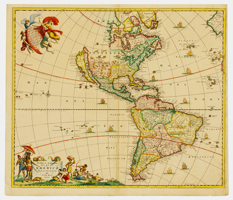
1670 Frederick De Wit Antique Map of America, California Island & 5 Great Lakes - !st Ed.
- Title : Novissima et Accuratissima totius Americae Descriptio.
- Date : 1670
- Size: 24in x 20 1/2in (605mm x 518mm)
- Ref #: 93117
- Condition: (A) Very Good Condition
Description:
This beautifully hand coloured original antique 1st edition map of America, with California as an Island, showing one of earliest depictions of the 5 Great Lakes, was published by the Dutch cartographer Frederick De Wit in 1670.
This 17th century Dutch map is magnificent with beautiful original hand colouring, a dark strong impression, denoting an early pressing, with a dark rich uniform age toning is one of the best De Wit map I have seen for sometime.
General Definitions:
Paper thickness and quality: - Heavy and stable
Paper color : - off white
Age of map color: - Original
Colors used: - Yellow, green, blue, pink
General color appearance: - Authentic
Paper size: - 24in x 20 1/2in (605mm x 518mm)
Plate size: - 23in x 19 1/2in (586mm x 492mm)
Margins: - Min 1/2in (12mm)
Imperfections:
Margins: - L& R margins extended from the plate-mark.
Plate area: - Bottom centerfold rejoined with a small rejoin adjacent to the bottom part of the centerfold.
Verso: - Uniform age toning
Background:
The first Dutch map to show five Great Lakes in North America. Based on de Wits great wall map of 1672, and with the Great Lakes considerably improved, as is the western coastline of Hudsons Bay. These two features are derived from Guillaume Sansons cartographic work published in 1669. The decorative cartouches are borrowed from the Nicolas Visschers America map of c.1658. The island of California shown with an indented northern coastline as per the Sanson model.. (Ref: Burden, Tooley, M&B)
de Wit, Frederick 1630 - 1706
Frederick de Wit (1629/1630 – 1706) was a Dutch cartographer and artist who drew, printed and sold maps. On maps his name is also written Frederic, Frederik, Frederico and Fredericus (Latinised). His surname is also written as de Witt and de Widt.
He was born in Gouda and died in Amsterdam. He was the company founder.
Frederick de Wit was born Frederick Hendricksz or Frederick son of Hendrick. He was born to a Protestant family in 1629/30, in Gouda, a small city in the province of Holland, one of the seven united provinces of the Netherlands. His father Hendrick Fredericsz (1608 – 29 July 1668) was a hechtmaecker (knife handle maker) from Amsterdam, and his mother Neeltij Joosten (d. before 1658) was the daughter of a merchant in Gouda. Frederick was married on 29 August 1661, to Maria van der Way (1632–1711), the daughter of a wealthy Catholic merchant in Amsterdam. From c. 1648 until his death at the end of July 1706, Frederick de Wit lived and worked in Amsterdam. Frederick and Maria had seven children, but only one Franciscus Xaverius (1666–1727) survived them.
By 1648, during the height of the Dutch Golden Age, De Wit had moved from Gouda to Amsterdam. As early as 1654 he had opened a printing office and shop under the name De Drie Crabben (the Three Crabs) which was also the name of his house on the Kalverstraat. In 1655, De Wit changed the name of his shop to the Witte Pascaert (the White Chart). Under this name De Wit and his firm became internationally known.
The first cartographic images that De Wit engraved were a plan of Haarlem that has been dated to 1648, and sometime before 1649 De Wit engraved the city views – city maps for the cities of Rijsel and Doornik that appeared in the richly illustrated Flandria Illustrata by the Flemish historian, Antonius Sanderus.[
The first charts engraved by De Wit were published in 1654 under the De Drie Crabben address. The first map that was both engraved and dated by De Wit was that of Denmark: REGNI DANIÆ Accuratissima delineatio Perfeckte Kaerte van t CONJNCKRYCK DENEMARCKEN in 1659. His first world maps, NOVA TOTIUS TERRARUM ORBIS TABULA AUCTORE F. DE WIT (approx. 43 × 55 cm) and Nova Totius Terrarum Orbis Tabula (a wall map approx. 140 × 190 cm) appeared around 1660.
His Atlas began to appear around 1662 and by 1671 included anywhere from 17 to 151 maps each. In the 1690s he began to use a new title page Atlas Maior but continued to use his old title page. His atlas of the Low Countries first published in 1667, was named Nieuw Kaertboeck van de XVII Nederlandse Provinciën and contained 14 to 25 maps. De Wit quickly expanded upon his first small folio atlas which contained mostly maps printed from plates that he had acquired, to an atlas with 27 maps engraved by or for him. By 1671 he was publishing a large folio atlas with as many as 100 maps. Smaller atlases of 17 or 27 or 51 maps could still be purchased and by the mid-1670s an atlas of as many as 151 maps and charts could be purchased from his shop. His atlases cost between 7 and 20 Guilders depending on the number of maps, color and the quality of binding (€47 or $70 to €160 or $240 today). In c. 1675 De Wit released a new nautical atlas. The charts in this atlas replaced the earlier charts from 1664 that are known today in only four bound examples and a few loose copies. De Wits new charts were sold in a chart book and as part of his atlases. De Wit published no fewer than 158 land maps and 43 charts on separate folio sheets.
In 1695 De Wit began to publish a town atlas of the Netherlands after he acquired a large number of city plans at the auction of the famous Blaeu publishing firms printing plates.
Dating De Wits atlases is considered difficult because usually no dates were recorded on the maps and their dates of publication extended over many years.
Through his marriage to Maria van der Way in 1661 he obtained, in 1662, the rights of Amsterdam citizenship and was able to become a member of the Guild of Saint Luke in 1664. In 1689 De Wit requested and received a fifteen-year privilege from the states of Holland and West Friesland that protected his right to publish and sell his maps. Then in 1694, he was named a good citizen of the city of Amsterdam.
After Frederick de Wits death in 1706 his wife Maria continued the business for four years printing and editing De Wits maps until 1710. However, as De Wits son Franciscus was already a prosperous stockfish merchant by this time and had little interest in his fathers business, he did not take over the publishing house. In 1710 Maria sold the firm at auction. At the auction most of the atlas plates and some of the wall map were sold to Pieter Mortier (1661–1711), a geographer, copper engraver, printer and publisher from Amsterdam. After Mortiers death, his firm eventually passed to the ownership of his son, Cornelis Mortier and Johannes Covens I who together founded Covens & Mortier on November 20, 1721. Covens & Mortier grew to become one of the largest cartography publishing houses of the 18th century. The 27 chart plates from his 1675 Sea atlas were sold at the 1710 auction, to the Amsterdam print seller Luis Renard, who published them under his own name in 1715, and then sold them to Rennier and Joshua Ottens who continued to publish them until the mid-1700s.
Most special collections libraries, rare map libraries, and private collections hold copies of De Wits atlases and maps. To date over 121 atlases and thousands of loose maps have been identified. Libraries that hold significant numbers are: The Amsterdam University Library, Utrecht University Library, Leiden University Library, Bibliothèque Royale Brussels, The Osher Map Library, Harvard Map Collection, Yale University Beinecke Library, The Library of Congress, Bayersche Staatsbibliothek, Staatsbibliothek zu Berlin, Österreichische Nationalbibliothek, Herzog August Bibliothek Wolfenbüttel, Sächsische Landesbibliothek-Staats-und Universitätsbibliothek Dresden, Hungarian National Library, and the collection bequeathed by William Dixson to the State Library of New South Wales. The museum at the Palazzo Rossi Poggi Marsili in Bologna has a map originally by Frederick de Wit (Nova totvs terrarvm orbis tabvla), engraved locally by Carlo Scotti (engraver)
1670 Nicolas Visscher Large Antique Map of South Holland Dordrecht, Gouda, Breda
Antique Map
- Title : Hollandiae Pars Merionalior Vulgo Zuyd-Holland Auctore Nic. Visscher
- Ref #: 93481
- Size: 26 1/2in x 21in (675mm x 515mm)
- Date : 1670
- Condition: (A+) Fine Condition
Description:
This original large beautifully hand coloured copper plate engraved antique map of South Holland, from the city of Gouda in the North to Breda in the South and centering on the city of Dordrecht, was published by Nicolas Visscher in 1670.
General Definitions:
Paper thickness and quality: - Heavy and stable
Paper color : - off white
Age of map color: - Original
Colors used: - Green, yellow, brown, pink
General color appearance: - Authentic
Paper size: - 26 1/2in x 21in (675mm x 515mm)
Plate size: - 22 1/2in x 18in (565mm x 460mm)
Margins: - Min 1in (25mm)
Imperfections:
Margins: - None
Plate area: - None
Verso: - None
Background:
The first city in South Holland to receive city rights was Dordrecht, which did so in 1220. The city retained a dominant position in the area until it was struck by a series of floods in the late 14th century. The same century also saw a series of civil wars, the Hook and Cod wars, concerning the succession of count William IV. Both his daughter Jacqueline and his brother John, the latter supported by Philip the Good, Duke of Burgundy, claimed the throne. The conflict ended in 1490, with John victorious.
Overall, the area of South Holland remained largely agrarian throughout the late Middle Ages. This changed around 1500, when Holland became Europes most urbanised area. During the Eighty Years War, the area of South Holland was the scene of the Capture of Brielle, the Siege of Leiden and the assassination of William the Silent.
The United Netherlands declared their independence in 1581, and Holland quickly emerged as the countrys dominant province, with important trading cities such as Leiden, Delft, Gouda and Dordrecht. In 1575, the Netherlands first university was founded in Leiden by William the Silent. The Hague, which had originated around the castle of the counts of Holland, became its new political centre. Both the States of Holland and the States General seated in the Binnenhof. The Dutch Golden Age blossomed in the 17th century. The south of Holland, back then often referred to as the Zuiderkwartier (literally South Quarter), was the birthplace and residence of many scientists such as Antoni van Leeuwenhoek and Christiaan Huygens, philosophers such as Baruch Spinoza and Pierre Bayle, as well as painters such as Johannes Vermeer, Rembrandt van Rijn and Jan Steen.
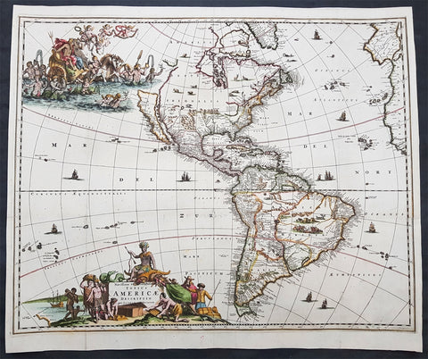
1671 Jacob Van Meurs Rare Original Antique Map of America - Island of California
- Title : Novissima et Accuratissima Totius Americae Descriptio per Jacobum Meursium
- Date : 1671
- Size: 22in x 19in (560mm x 485mm)
- Ref #: 61157
- Condition: (A) Very Good Condition
Description: This uncommon and rare original antique map of America and the Pacific, including parts of New Zealand, was published in Amsterdam by Jacob Van Meurs in 1671 for the German edition of Arnold Montanus' ground breaking publication "America". (Ref: Burden, Tooley, Koeman)
General Description:
Paper thickness and quality: - Heavy and stable
Paper color: - off white
Age of map color: - Early
Colors used: - Green, red, orange, yellow, blue
General color appearance: - Authentic
Paper size: - 22in x 19in (560mm x 485mm)
Plate size: - 21 3/4in x 17 1/2in (550mm x 445mm)
Margins: - Min 1/2in (12mm)
Imperfections:
Margins: - Light soiling
Plate area: - Folds as issued, light separation along folds, no loss
Verso: - Professionally backed onto Japanese archival rice paper
Background: Unlike the Dutch edition of this map (by Van Schaegen) and English edition (by John Ogilby), which copied the De Wit / Visscher America map, Van Meurs creates a highly decorative new plate for the German edition of Montanus' America. The plate was later acquired by Pierre Vander Aa and re-issued bearing Vander Aa's name circa 1714.
The map shows California as an Island on the first Sanson Projection, showing a single large Great Lake (open at the west), a curious north-easterly coastline north of the Island of California and a geographically misaligned South America, with tribal vignettes in Brazil and wild life in North America. The map predates La Salle's information on the interior of North America, but includes excellent detail on Canada and the East Coast of North America, noting the Dutch Possessions, the Iroquois regions, N. Anglia, New Amsterdam, the Cheaspeak, Plymouth, and many Indian Place names.
Meurs's map is based upon Nicholas Visscher's map of 1658, in that it includes the coastline New Zealand and the early Sanson model for California, and only shows one of the Great Lakes, updated from Visscher's edition. Visscher in turn drew his information from Joan Blaeu's wall map of the World, published in 1648.
The map is most notable for its elaborate allegorical cartouches. One of the most outstanding features of this map are the beautifully engraved decorative cartouches that include numerous vignettes of wildlife, American Indians, sailing ships and battles. The title is surrounded by Native Americans trading with Europeans and in the North Pacific is a lavish scene of Neptune and his consort in a chariot surrounded by his entourage and putti. The map was to be included in Montanus book of America and so has folds as issued. (Ref: Burden, Tooley, Koeman)
1671 John Ogilby 1st Antique English map of The Island of Jamaica, Caribbean
- Title : Novissima et Acccuratissima Jamaicae Descriptio per Johannem Ogiluium Cosmographum Regnum 1671
- Size: 21 1/4in x 17 1/4in (515mm x 440mm)
- Condition: (B) Good Condition
- Date : 1671
- Ref #: 82081
Description:
This beautifully hand coloured original copper-plate engraved antique map of the Caribbean Island of Jamaica - the first English map of the Island - by John Ogilby was engraved by Francis Lamb (active 1665 - 1700) in 1671 - dated - and published in the atlas America: Being The latest, And Most Accurate Description Of The New World; Containing The Original of the Inhabitants, and the Remarkable Voyages thither. The Conquest Of The Vast Empires Of Mexico and Peru, and Other Large Provinces and Territories, With The Several European Plantations In Those Parts. Also Their Cities, Fortresses, Towns, Temples, Mountains, and Rivers
This map has undergone some restoration, as with most of the folded maps from Ogilbys America, mainly to the borders and is reflected in the price. Please see further details below.
This is the earliest detailed English maps of Jamaica. It had a significant influence on subsequent maps and is based on surveys by John Man, Jamaicas surveyor general. Ogilbys map divides the island into named precincts and notes major cities and plantations. A large inset below lists the plantations and indicates whether they produce cocoa, indigo, sugar and/or cotton. On either side is a decorative title cartouche and a mileage cartouche adorned with putti. This is one of the few original maps from Ogilbys America.
General Definitions:
Paper thickness and quality: - Heavy and stable
Paper color : - off white
Age of map color: - Original
Colors used: - Yellow, green, blue, pink
General color appearance: - Authentic
Paper size: - 21 1/4in x 17 1/4in (515mm x 440mm)
Plate size: - 21 1/4in x 17 1/4in (515mm x 440mm)
Margins: - Min 0in (0mm)
Imperfections:
Margins: - All margins cropped to plate-marks. Right border restored, part of the bottom left & bottom center border restored.
Plate area: - Light creasing, re-enforced along original folds
Verso: - Re-enforced along original folds, soiling
Background:
Jamaica is an island country situated in the Caribbean Sea. Previously inhabited by the indigenous Arawak and Taíno peoples, the island came under Spanish rule following the arrival of Christopher Columbus in 1494. Many of the indigenous people died of disease, and the Spanish transplanted African slaves to Jamaica as labourers. The island remained a possession of Spain until 1655, when England conquered it and renamed it Jamaica. Under British colonial rule Jamaica became a leading sugar exporter, with its plantation economy highly dependent on African slaves. The British fully emancipated all slaves in 1838, and many freedmen chose to have subsistence farms rather than to work on plantations. Beginning in the 1840s, the British utilized Chinese and Indian indentured labour to work on plantations.
Spanish Town has the oldest cathedral of the British colonies in the Caribbean. The Spanish were forcibly evicted by the English at Ocho Rios in St. Ann. In the 1655 Invasion of Jamaica, the English, led by Sir William Penn and General Robert Venables, took over the last Spanish fort on the island. The name of Montego Bay, the capital of the parish of St. James, was derived from the Spanish name manteca bahía (or Bay of Lard), alluding to the lard-making industry based on processing the numerous boars in the area.
In 1660, the population of Jamaica was about 4,500 white and 1,500 black. By the early 1670s, as the English developed sugar cane plantations and imported more slaves, black people formed a majority of the population. The colony was shaken and almost destroyed by the 1692 Jamaica earthquake.
The Irish in Jamaica also formed a large part of the islands early population, making up two-thirds of the white population on the island in the late 17th century, twice that of the English population. They were brought in as indentured labourers and soldiers after the conquest of Jamaica by Cromwells forces in 1655. The majority of Irish were transported by force as political prisoners of war from Ireland as a result of the ongoing Wars of the Three Kingdoms at the time. Migration of large numbers of Irish to the island continued into the 18th century.
Jews were expelled from Spain in 1492 and then forcibly converted to Christianity in Portugal, during a period of persecution by the Inquisition. Some Spanish and Portuguese Jewish refugees went to the Netherlands and England, and from there to Jamaica. Others were part of the Iberian colonisation of the New World, after overtly converting to Catholicism, as only Catholics were allowed in the Spanish colonies. By 1660, Jamaica had become a refuge for Jews in the New World, also attracting those who had been expelled from Spain and Portugal.
An early group of Jews arrived in 1510, soon after the son of Christopher Columbus settled on the island. Primarily working as merchants and traders, the Jewish community was forced to live a clandestine life, calling themselves Portugals. After the British took over rule of Jamaica, the Jews decided the best defense against Spains regaining control was to encourage making the colony a base for Caribbean pirates. With the pirates installed in Port Royal, which became the largest city in the Caribbean, the Spanish would be deterred from attacking. The British leaders agreed with the viability of this strategy to forestall outside aggression.
When the English captured Jamaica in 1655, the Spanish colonists fled after freeing their slaves. The slaves dispersed into the mountains, joining the maroons, those who had previously escaped to live with the Taíno native people. During the centuries of slavery, Maroons established free communities in the mountainous interior of Jamaica, where they maintained their freedom and independence for generations. The Jamaican Maroons fought the British during the 18th century. Under treaties of 1738 and 1739, the British agreed to stop trying to round them up in exchange for their leaving the colonial settlements alone, but serving if needed for military actions. Some of the communities were broken up and the British deported Maroons to Nova Scotia and, later, Sierra Leone. The name is still used today by modern Maroon descendants, who have certain rights and autonomy at the community of Accompong.
During its first 200 years of British rule, Jamaica became one of the worlds leading sugar-exporting, slave-dependent colonies, producing more than 77,000 tons of sugar annually between 1820 and 1824. After the abolition of the international slave trade in 1807, the British began to import indentured servants to supplement the labour pool, as many freedmen resisted working on the plantations. Workers recruited from India began arriving in 1845, Chinese workers in 1854.
Ogilby, John 1600-1676
Ogilby was a Scottish cartographer and publisher. Ogilby is perhaps best known for his series of road-maps entitled the Britannia, which was the first road-atlas of any country, published in 1675.
1672 Nicolas Denys Extremely Rare Map of Acadia, Quebec, Nova Scotia Canada
Antique Map
- Title : (Acadia; Quebec)
- Size: 20 3/4in x 16in (680mm x 520mm)
- Condition: (A) Very Good Condition
- Date : 1672
- Ref #: 31916
Description:
This original copper plate engraved, antique very rare map of Acadia, Nova Scotia in eastern Canada by the founding father of Acadia Nicolas Denys, was published in his 1672 edition of Description Géographique et Historique des Costes de l'Amérique Septentrionale....
The map is very rare, since a number of the copies of the book do not appear to have had the map included. From our research we have realised two versions of this map, with an obvious difference. One map that shows latitude 42 numeric at the bottom left and another edition without.
The map without the numeric 42 can be seen online, from the McGill university, digitised by the Haiti Trust online library, P #38.
The map with the numeric can be found on the Gallica open-access digital library of the Bibliothèque nationale de France (BnF)
Both are easily searchable on each site using Denys name.
There are also other copies to be found online.
The map carries 92 place names. On it Denys delineates the coasts he explored and traded on, from Penobscot Bay to Cap Gaspe, including all of Nova Scotia.
Nicolas Denys was a founding father of Acadia and one of its leading figures for over half of the 17th century. Denys was given Cape Breton Island by Louis XIV, in 1670, as a reward for services rendered. He wrote his account of the region at Nipisiguit on Chaleur Bay.
The map contains a number of place names, which are still in use today, that did not appear on earlier printed maps : Le Fort de St. Pierre, La R. de Cocanne, Le Cap de Tourmentin, Chedabouctou… Denys used the basic cartography of Sanson for mainland Nova Scotia, Quebec and New Brunswick, but with an entirely new, although distorted outline for Cape Breton.
He shows a large inlet, Le Lac de Labrador, which was sometimes retained by later cartographers, with its southwest corner separated by a wide isthmus from sea at Le fort de St. Pierre, present-day St. Peters Bay.
General Definitions:
Paper thickness and quality: - Heavy and stable
Paper color : - off white
Age of map color: -
Colors used: -
General color appearance: -
Paper size: - 20 3/4in x 16in (680mm x 520mm)
Plate size: - 20 3/4in x 16in (680mm x 520mm)
Margins: - Min 1/2in (15mm)
Imperfections:
Margins: - Light chipping to left edge
Plate area: - Folds as issued, light creasing along folds
Verso: - Folds as issued, light creasing along folds, several small re-joins of folds to edges
Background: A century and a half after the first voyage of Columbus in 1492, northern North America beyond the Atlantic coastline was still barely known.
Before 1656 three entryways had been established: Davis Strait, Hudson Bay, and the St Lawrence valley It took another century and a half of laborious probing across the great plains and through the western mountains to reach the Pacific coast, where explorers met other Europeans who were arriving there too, overseas from the west.
Portuguese, Spanish, and Russians dominated the earliest coastal reconnaissance activity but then retreated. Inland the French uncovered what became Canada’s ecumene in the 20th century, while the British uncovered the rest of the landmass, all the way to the Arctic Ocean. The Canadian landmass was however revealed largely because it fed a craze for fur-based consumer products in Europe.
In the last years before 1632, inland explorers for the first time bridged gaps between places already known: between modern Quebec City and the coast of Maine, and between the Delaware River and Lake Ontario.
Throughout this period of 135 years, the coast of Labrador and northeastern Newfoundland were the most heavily traveled parts of the future Canadian territory.
Exploration of the fiords of today’s British Columbia coast and Alaska panhandle intensified in the last quarter of the eighteenth century, and in 1793 Alexander Mackenzie, a Montrealer, reached the head of one of those fiords at Bella Coola. He thus completed the land crossing of America begun some two centuries earlier.
After nearly two centuries, Great Britain was actively seeking the Northwest Passage and in 1818 a newly established border with the United States created another need for new and more accurate maps.
Nicolas Denys (1598? – 1688) was a French-born merchant, governor, writer, and settler in New France. He founded settlements at St. Pierre (now St. Peter's, Nova Scotia), Ste. Anne (Englishtown, Nova Scotia) and Nepisiquit (Bathurst, New Brunswick).
Denys' writings about the lands and peoples of Acadia were published in two volumes in 1672. The work, entitled The Description and Natural History of the Coasts of North America, remains the leading authority regarding the conditions of Acadia for the years 1632 through 1670.
When Cardinal Richelieu authorized a stronger French presence in the New World, he commissioned Isaac de Razilly to be lieutenant-general of Acadia and Nicolas Denys accompanied the expedition as one of de Razilly's lieutenants. The expedition set sail in 1632 with 300 hand-picked men, supplies, six Franciscan missionaries, and Simon Denys (Denis) de La Trinité (1599-1678), brother of Nicolas Denys. Simon Denys was a future seigneurial attorney and receiver general for the Compagnie des Cent-Associés, who was appointed to the ruling Sovereign Council of New France in 1664, then ennobled by Louis XIV, in 1668.
They founded a colony at the LaHave River where Denys engaged in inshore fishing, lumbering and fur trading. French administrators, including nearby Port Royal's lord, the Sieur Charles de Menou d'Aulnay, thought little of the colonists’ reclaiming tidal marshlands. Denys was very impressed with the “great extent of meadows which the sea used to cover and which the Sieur d'Aulnay has drained” It was this extensive system of dikes and drainage sluices (called aboiteaux) that set his colony apart from any others. It allowed the colonists to reclaim land that the Mi'kmaq nation had no use for. This greatly aided peaceful co-existence with their neighbors, and Mi’kmaq trade, friendship and intermarriage was and is an immensely important part of the Acadian identity and heritage.
When Denys arrived in 1632 the aboriginal community was already using iron kettles, axes, knives, and arrowheads, but few had firearms. Before the use of kettles the Mi’kmaq used hollowed out tree trunks in which to boil their unsalted food, dropping in hot stones to heat the water. Possessing kettles, they were free to move anywhere and became more mobile, changing their habitations often. Denys remarked on excessive hunting in his diaries. Moose, formerly in great numbers on Cape Breton Island, had been exterminated by hunting with muskets. There were no longer any moose on Prince Edward Island and the caribou were in reduced number. Alcohol, however, not over-hunting, was a major cause of Mi’kmaq decline.
When de Razilly died in December 1635 the colony broke up and Nicolas Denys returned temporarily to France. In 1636, Denys was granted a seignory by the French crown, apparently the third grant in the colony of Acadie and in 1642 he married Marguerite de Lafitte in France, but soon took his new family across to his adopted lands of Acadia.
Denys was a witness to one of the most unfortunate chapters of early Acadia's history: the rivalry between the Lords d’Aulnay and Charles de Saint-Étienne de la Tour, as it dissipated efforts to grow the colony. La Tour had claimed royal permission to ply the fur trade in the American Northeast. His rival outposts were in often-open hostility with the budding d’Aulnay colony, competing for resources and markets. Decades of sparring led to bloodshed. In the Spring of 1643 La Tour led a party of English mercenaries against the Acadian colony at Port Royal. His 270 Puritan and Huguenot troops killed three Acadians, burned a mill, slaughtered cattle and seized 18,000 livres' worth of furs. D'Aulnay retaliated in 1645 by seizing all of La Tour's possessions and outposts while La Tour was drumming up more support for his cause in the English colonial port of Boston. Denys’ letters and journals give vivid descriptions of the drama.
Once he secured rights to his own lands in Acadia through the Company of New France, Denys continued to seek his fortunes now as the Governor of Canso and Isle Royale (present-day Cape Breton Island). Denys founded settlements at St. Pierre (now St. Peter's, Nova Scotia, site of the Nicholas Denys Museum), Ste. Anne (Englishtown, Nova Scotia) and Nepisiquit (Bathurst, New Brunswick).
His 'fortunes' had some reversals, however. Sieur Emmanuel le Borgne, a rival with holdings at Port Royal, seized his properties by armed force in 1654 while Denys was at Ste. Anne. Later that year, King Louis XIV recognized Denys’ claims to the property lost to le Borgne and Le Borgne was commanded to restore them to Denys.
The Denys family, including his wife and son Richard Denys, made their home in St. Pierre, and dwelt there in relative calm until the Winter of 1669, when Nicolas’ home and business were consumed in a fire. Denys relocated his family to Nepisiquit, on Baie Chaleur, just south of the Gaspé Peninsula, and there he turned his efforts to writing. Leaving his son Richard in charge of his holdings, he travelled to Paris to publish his Description Géographique et Historique des Costes de l’Amérique Septentrionale: avec l’Histoire Naturelle du Païs. Released in 1672, it was not a success. He remained in Paris for several years, returning impoverished to Nepisiguit a few years before his death.
Denys died in 1688 at Nepisiquit, a town of his own creation. During his tenure in the New World, he appears to have offered more stability of governance than those other royal appointees around him. Denys is well known through his writings about the lands and peoples of Acadia, especially his Description, published in two volumes in 1672. This work was edited and translated into English by Professor William Francis Ganong and published in 1908 as part of the Champlain Society's General Series. Ganong was a distant cousin of Denys.
Nicolas Denys and his work, translated as Description and Natural History of the Coasts of North America, remains the leading authority regarding the conditions of Acadia for the years 1632 through 1670.
Please note all items auctioned are genuine, we do not sell reproductions. A Certificate of Authenticity (COA) can be issued on request.

1673 Blome Antique Map Islands of Great Britain - Shetlands, Man, Wight, Channel
Antique Map
-
Title : A Mapp of the Isles of Wight, Jarsey, Garnsey, Sarke, Man, Orcadies and Shetland by Ric Blome by his Matys. Command
- Ref #: 17013
-
Condition: (A+) Fine Condition
- Size: 15in x 12 1/2in (380mm x 320mm)
- Date : 1673
Description:
This original hand coloured, copper plate engraved antique map of the Islands of Great Britain - Shetlands, Man, Wight, Orkenys, Jersey, Guernsey & Sark (Channel Islands) - was published by Richard Blome in the 1673 edition of Britannia: or, A Geographical Description of the Kingdoms of England, Scotland, and Ireland, with the Isles and Terrotories thereto belonging.
General Definitions:
Paper thickness and quality: - Heavy and stable
Paper color : - off white
Age of map color: - Early
Colors used: - Yellow, green, blue, pink
General color appearance: - Authentic
Paper size: - 15in x 12 1/2in (380mm x 320mm)
Plate size: - 14 1/2in x 11in (370mm x 280mm)
Margins: - Min 1/8in (5mm)
Imperfections:
Margins: - Light age toning in margins
Plate area: - None
Verso: - None
Please note all items auctioned are genuine, we do not sell reproductions. A Certificate of Authenticity (COA) can be issued on request.
1674 Alex Jaillot Large Antique 1st edition Map of Africa - L Afrique Divisee
Antique Map
- Title : L Afrique Divisee Suivant l'Estendue de ses Principales Parties...Alexis Hubert Jaillot...1674
- Ref #: 50667
- Size: 36in x 24 1/2in (915mm x 620mm)
- Date : 1674
- Condition: (A) Very Good Condition
Description:
This large, exquisitely hand coloured, original antique 1st edition map of Africa by Alexis Hubert Jaillot - after Nicolas Sanson - was engraved in 1674 - the date is engraved in the scale cartouche.
This is a beautifully presented map, fantastic colour on sturdy & heavy paper with a deep clear impression, signifying a very early pressing.
This 1st edition map is not to be confused with the later smaller more common version of the map published by A.H. Jaillot. There are 5 editions of this map published in 1674, 1685, 1690, 1692 & 1695.
General Description:
Paper thickness and quality: - Heavy and stable
Paper color: - off white
Age of map color: - Original
Colors used: - Yellow, green, red, orange.
General color appearance: - Authentic and fresh
Paper size: - 36in x 24 1/2in (915mm x 620mm)
Plate size: - 35in x 23in (890mm x 585mm)
Margins: - Min 1/2in (25mm)
Imperfections:
Margins: - Light age toning in margins, bottom margin corners cropped
Plate area: - Light age toning & creasing along centerfold
Verso: - Light age toning & creasing along centerfold
Background: Being part of the Mediterranean world, the northern coasts of the African continent as far as the Straits of Gibraltar and even round to the area of the Fortunate Isles (the Canaries) were reasonably well known and quite accurately mapped from ancient times. In particular, Egypt and the Nile Valley were well defined and the Nile itself was, of course, one of the rivers separating the continents in medieval T-O maps. Through Arab traders the shape of the east coast, down the Red Sea as far as the equator, was also known but detail shown in the interior faded into deserts with occasional mountain ranges and mythical rivers. The southern part of the continent, in the Ptolemaic tradition, was assumed to curve to the east to form a land-locked Indian Ocean. The voyages of the Portuguese, organized by Henry the Navigator in the fifteenth century, completely changed the picture and by the end of the century Vasco da Gama had rounded the Cape enabling cartographers to draw a quite presentable coastal outline of the whole continent, even if the interior was to remain largely unknown for the next two or three centuries.
After Nicolas Sanson, Hubert Jaillot and Pierre Duval were the most important French cartographers of the seventeenth centuries. Jaillot, originally a sculptor, became interested in geography after his marriage to the daughter of Nicolas Berey (1606-65), a famous map colourist, and went into partnership in Paris with Sanson's sons. There, from about 1669, he undertook the re-engraving, enlarging and re-publishing of the Sanson maps in sheet form and in atlases, sparing no effort to fill the gap in the map trade left by the destruction of Blaeu's printing establishment in Amsterdam in 1672. Many of his maps were printed in Amsterdam (by Pierre Mortier) as well as in Paris. One of his most important works was a magnificent sea atlas, Le Neptune François, published in 1693 and compiled in co-operation with J D Cassini. This was re-published shortly afterwards by Pierre Mortier in Amsterdam with French, Dutch and English texts, the charts having been re-engraved. Eventually, after half a century, most of the plates were used again as the basis for a revised issue published by J N Bellin in 1753.(Ref: Tooley; M&B)
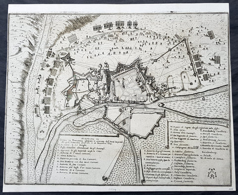
1675 Merian Antique Map Birds Eye View Siege of Szczecin, Stettin Poland in 1659
Antique Map
- Title : Abzeichnung der Belägerung der Statt Stettin in Pommeren wie dieselbe von denen Kayserlichen vom 29.Sept. biß auf den 15. Novemb. Anno 1659 angegriffen und bestritten worden
- Ref #: 93491
- Size: 15 1/2in x 13in (395mm x 340mm)
- Date : 1675
- Condition: (A+) Fine Condition
Description:
This original copper-plate engraved antique map a birds-eye view of the siege of Szczecin or Stettin, Poland in 1659 - with illustrations of military positions surrounding the city - by Matthaus Merian was published in the 1675 edition of Theatrum Europaeum
During the Thirty Years War, Stettin refused to accept German imperial armies, instead the Pomeranian dukes allied with Sweden. After the Treaty of Stettin (1630) manifested Swedish occupation, Stettin was fortified by the Swedish Empire. After the death of the last Pomeranian duke, Boguslaw XIV, Stettin was awarded to Sweden with the western part of the duchy in the Peace of Westphalia (1648), but remained part of the Holy Roman Empire. The Swedish-Brandenburgian border was settled in the Treaty of Stettin (1653). The King of Sweden became Duke of Pomerania and as such held a seat in the Imperial Diet of the Holy Roman Empire. The city was cut off from its main trading area, and was besieged in several wars with Brandenburg which shattered the citys economy, which fell in prolonged economic decline.
In 1654 the last Pomeranian duke Boguslaw XIV was buried in the Ducal Castle.
General Definitions:
Paper thickness and quality: - Heavy and stable
Paper color : - off white
Age of map color: -
Colors used: -
General color appearance: -
Paper size: - 15 1/2in x 13in (395mm x 340mm)
Plate size: - 15 1/2in x 13in (395mm x 340mm)
Margins: - Min 1/8in (2mm)
Imperfections:
Margins: - Left margin cropped close to border
Plate area: - None
Verso: - None
Background:
Szczecin/Stettin is the capital and largest city of the West Pomeranian Voivodeship in northwestern Poland. Located near the Baltic Sea and the German border, it is a major seaport and Polands seventh-largest city.
Szczecin is located on the river Oder, south of the Szczecin Lagoon and the Bay of Pomerania. The city is situated along the southwestern shore of Dąbie Lake, on both sides of the Oder and on several large islands between the western and eastern branches of the river. Szczecin is adjacent to the town of Police and is the urban centre of the Szczecin agglomeration, an extended metropolitan area that includes communities in the German states of Brandenburg and Mecklenburg-Vorpommern.
The cities recorded history began in the 8th century as a Lechitic Pomeranian stronghold, built at the site of the Ducal castle. In the 12th century, when Szczecin had become one of Pomeranias main urban centres, it lost its independence to Piast Poland, the Duchy of Saxony, the Holy Roman Empire and Denmark. At the same time, the House of Griffins established themselves as local rulers and the population was Christianized. After the Treaty of Stettin in 1630, the town came under the control of the Swedish Empire and became in 1648 the Capital of Swedish Pomerania until 1720, when it was acquired by the Kingdom of Prussia and then the German Empire. Following World War II Stettin became part of Poland in accordance with the Potsdam Agreement, resulting in the almost complete expulsion of the pre-war German population.
1676 John Speed Antique Atlas Title Pages x 2 Empire of Great Britaine & World
Antique Map
- Title : The Theatre of the Empire of Great Britaine, A Prospect of the most famous Parts of the World by John Speed...London Thomas Bassett and Richard Chiswell 1676; The Achievement of our Soveraigne King Charles the 11D.
- Date : 1676
- Size: 22 1/2in x 17 1/2in (570mm x 445mm)
- Ref #: 42005/42006
- Condition: (A+) Fine Condition
- Price: $1250.00US
Description:
This original beautifully hand coloured, copper plate engraved antique Title and Dedication Pages was published for the 1676 edition of John Speeds double atlas The Theatre of the Empire of Great Britaine & Atlas A Prospect of the most Famous Parts of the World printed by Thomas Bassett and Richard Chiswell, London.
General Definitions:
Paper thickness and quality: - Heavy and stable
Paper color : - off white
Age of map color: - Later
Colors used: - Yellow, green, blue, pink
General color appearance: - Authentic
Paper size: - 22 1/2in x 17 1/2in (570mm x 445mm)
Plate size: - 15 1/4in x 9 3/4in (385mm x 250mm) each
Margins: - Min 1/2in (12mm)
Imperfections:
Margins: - Light age toning
Plate area: - Light age toning
Verso: - Light age toning
Background:
John Speeds The Theatre of the Empire of Great Britaine was published in 1610/11 by John Sudbury and George Humble, and contained the first set of individual county maps of England and Wales besides maps of Ireland and a general map of Scotland. Most, but not all, of the county maps have town plans on them; those showing a Scale of Passes being the places he had mapped himself. The county maps were the first consistent attempt to show territorial divisions, such as boundaries of hundreds, but it was Speed’s town plans that were a major innovation and probably his greatest contribution to British cartography. The Theatre was an immediate success: the first print run of around 500 copies must have sold quickly because many editions followed. Sudbury and Humble realized, given the increasing popularity of both county and world atlases and in the light of the success of Abraham Ortelius’s Theatrum Orbis Terrarum, the potential demand for an English world atlas.
In 1627, two years before his death, Speed published Prospect of the Most Famous Parts of the World with 21 finely engraved maps, which was the first world atlas produced by an Englishman. There is a fascinating text describing the areas shown on the back of the maps in English, although a rare edition of 1616 of the British maps has a Latin text – this is believed to have been produced for the Continental market. Its maps are famous for their bordering panels of national characters in local costume and panoramic views depicting the areas of major towns and cities. Much of the engraving was done in Amsterdam at the workshop of Jodocus Hondius. The maps of the world and America show California as an island and are amongst the earliest ever printed to depict this seventeenth-century cartographic myth.
1676 John Speed Antique County Map of MonmouthShire - Beautiful Original Colour
Antique Map
- Title : The Countye of Monmouth Anno 1610
- Date : 1676
- Size: 21in x 16in (535mm x 405mm)
- Condition: (A+) Fine Condition
- Ref: 35623
Description:
This original hand coloured copper plate engraved antique county map & views of Monmouth Shire and Monmouth City by John Speed was published in the 1676 Bassett & Chiswell edition of Speeds famous atlas The Theatre of the Empire of Great Britaine.
The map is embellished with the famous birds-eye views of the county and city with descriptive text on the verso.
General Definitions:
Paper thickness and quality: - Heavy and stable
Paper color : - off white
Age of map color: - Original
Colors used: - Yellow, green, blue, pink
General color appearance: - Authentic
Paper size: - 21in x 16in (535mm x 405mm)
Plate size: - 20 1/2in x 15 1/4in (520mm x 385mm)
Margins: - Min 1/2in (10mm)
Imperfections:
Margins: - Age toning
Plate area: - Age toning
Verso: - Age toning
Background:
John Speeds The Theatre of the Empire of Great Britaine was published in 1610/11 by John Sudbury and George Humble, and contained the first set of individual county maps of England and Wales besides maps of Ireland and a general map of Scotland. Most, but not all, of the county maps have town plans on them; those showing a Scale of Passes being the places he had mapped himself. The county maps were the first consistent attempt to show territorial divisions, such as boundaries of hundreds, but it was Speed’s town plans that were a major innovation and probably his greatest contribution to British cartography. The Theatre was an immediate success: the first print run of around 500 copies must have sold quickly because many editions followed. Sudbury and Humble realized, given the increasing popularity of both county and world atlases and in the light of the success of Abraham Ortelius’s Theatrum Orbis Terrarum, the potential demand for an English world atlas.
In 1627, two years before his death, Speed published Prospect of the Most Famous Parts of the World with 21 finely engraved maps, which was the first world atlas produced by an Englishman. There is a fascinating text describing the areas shown on the back of the maps in English, although a rare edition of 1616 of the British maps has a Latin text – this is believed to have been produced for the Continental market. Its maps are famous for their bordering panels of national characters in local costume and panoramic views depicting the areas of major towns and cities. Much of the engraving was done in Amsterdam at the workshop of Jodocus Hondius. The maps of the world and America show California as an island and are amongst the earliest ever printed to depict this seventeenth-century cartographic myth.
1676 John Speed Antique Map of County of Midlesex Views London & Westminster
- Title : Midle-sex Described with the most Famous Cities of London and Westminster
- Date : 1676
- Size: 20 1/4in x 16 3/4in (515mm x 425mm)
- Condition: (B) Good Condition
- Ref: 35613
Description:
This original hand coloured copper plate engraved antique map & views of London and the English county of Middlesex by John Speed was published in the 1676 Bassett & Chiswell edition of Speeds famous atlas The Theatre of the Empire of Great Britaine.
The map is embellished with the famous birds-eye views of London, Westminster and the churches of St Peters (Westminster Abbey) and old St Pauls before the great fire of London in 1666. English descriptive text of London on the verso.
General Definitions:
Paper thickness and quality: - Heavy and stable
Paper color : - off white
Age of map color: - Original
Colors used: - Blue, yellow, green, pink
General color appearance: - Authentic
Paper size: - 20 1/4in x 16 3/4in (515mm x 425mm)
Plate size: - 20 1/4in x 15 1/2in (515mm x 410mm)
Margins: - Min 1/8in (2mm)
Imperfections:
Margins: - L&R margins cropped to plate-marks
Plate area: - Re-enforced along centerfold very small loss in places, light creasing
Verso: - Re-enforced along centerfold and in several places with transparent archival tape
Background:
This county map of Middlesex, now greater London, illustrates the market towns of Enfield, Pancras, Osterley and Staines. The map is dominated by four large vignettes with the environs of London and the county situated in the central portion of the map. The actual cartography is based on the surveys performed by John Norden, the earlier English antiquary and map maker, who unsuccessfully attempted to publish an updated county atlas of the United Kingdom before Speed. Norden also lived most of his life in Middlesex, thus becoming an obvious source for the map.
The City of London is clearly shown on the lower right of the map with villages such as Hamsted, Pancras, Kensington and Paddington marked around the city. To the lower centre of the map is an acknowledgement to the original survey by Norden, augmented by Speed himself.
Although the cartography is of some note, it is the vignettes for which this map is justly famous. To the two bottom corners are the famous Churchs of St. Peter (Westminster Abbey) Westminster on the left and St. Pauls to the right. This is the medieval Cathedral of St. Pauls, just after it had lost its spire in 1561 and before the Great Fire of 1666, in which it was destroyed then rebuilt in its present form by Sir Christopher Wren. Above these two church vignettes are two text panels in the form of books, the one on the left describing the two churches and the other on the right with a description of London itself.
Finally, two large vignettes on the upper left and right corners depict the two cities of Westminster and London respectively. It is believed that Speed was not responsible for either of these images, more likely drawing from Norden, although there are no surviving evidence of this, to date yet to be found. There are also theories that these two views may have come from either a German sources or other lost birds-eye views of London by unknown persons.
Due to modern growth of London and border changes, the county of Middlesex no longer exists, but there is little doubt this is the most the best map of London and Middlesex published in the 17th century. English text on verso
1676 Pieter Goos Large Antique Map of England, Thames River, London
Antique Map
- Title : Pascaarte van Engelant van t' Voorlandt tot aen Blakeney waer in te Sien is de Mont vande Teemse
- Date : 1676
- Condition: (A) Very Good Condition
- Ref: 42012
- Size: 22in x 18in (560mm x 455mm)
Description:
This large, beautifully hand coloured original antique map, a fine early Dutch sea chart of the Thames River and surrounding English coastline, was published by Pieter Goos in 1676 for the Goos De Zee-Atlas, Ofte Water-Weereld, Atlas.
This chart is oriented with north to the right includes in the upper right is a large inset of the Thames River and plan of London. Beautifully engraved with original coulouring embellished with rhumb lines, two compass roses and a galleon under sail. (Ref: Tooley; M&B; Koeman)
General Description:
Paper thickness and quality: - Heavy and stable
Paper color: - off white
Age of map color: - Original
Colors used: - Yellow, green, red, rose madder, red
General color appearance: - Authentic and fresh
Paper size: - 22in x 18in (560mm x 455mm)
Plate size: - 22in x 18in (560mm x 455mm)
Margins: - Min ½in (12mm)
Imperfections:
Margins: - Top L&R margin corner ink spill not affecting image
Plate area: - None
Verso: - Light soiling
1677 De Rossi Large Original Antique Map of Denmark & Sweden, Schleswig Holstein
- Title : Regno di Danimarca Diuiso nelle Sue due Iutlandie Cioe settentrionale in quattro Diocesi Et Australe, e` il Ducato di...Gio Giacomo De Rossi....L Anno 1677
- Date : 1677
- Size: 22 1/2in x 18in (575mm x 460mm)
- Ref #: 50610
- Condition: (A) Very Good Condition
Description:
A beautiful and quite scarce original 1677 antique map of Denmark and southern Sweden, was engraved in 1677 - dated in the title - and was published in the 1692 edition of de Rossi's world atlas Mercurio Geografico
General Definitions:
Paper thickness and quality: - Heavy and stable
Paper color : - off white
Age of map color: - Early
Colors used: - Yellow, green, blue, pink
General color appearance: - Authentic
Paper size: - 22 1/2in x 18in (575mm x 460mm)
Plate size: - 20 1/2in x 16in (420mm x 405mm)
Margins: - Min 1in (25mm)
Imperfections:
Margins: - Professional repairs to top & bottom margins
Plate area: - Professional repairs to centerfold
Verso: - Repairs as noted
Background:
Before the fifteenth century the people of Southern Europe had little geographical knowledge of the Scandinavian World except from sketchy detail shown in the Catalan Atlas (1375) and on a number of " portolani" embracing Denmark and the southern tip of Norway. It was not until 1427 that a manuscript map prepared about that time by Claudius Clavus (b.1388) a Dane who spent some time in Rome, made available to scholars a tolerable outline of the northern countries and Greenland. That was to remain the best map available for the rest of the century and it was used as the basis for maps of Scandinavia in early printed editions of Ptolemy. Others by Nicolaus Cusanus (1491) and Ehrhard Etzlaub (c. 1492) followed but, needless to say, these are extremely rare; even the later maps by Olaus Magnus and Marcus Jordan, where they have survived at all , are known only by a very few examples. In fact, apart from the rare appearance of an early Ptolemy map, the oldest of Scandinavia which a collector is likely to find are those of Munster's Cosmograhy first published in 1544. In the following centuries the few maps and charts complied in Scandinavia were usually published in Amsterdam, Antwerp, Paris or Nuremberg, the most important maps often being incorporated in the major Dutch, French & German Atlases. (Ref: Tooley; M&B)
1677 Nicolas Visscher Antique Twin Hemisphere World Map
- Title : Orbis Terrarum Tabula Recens Emendata Et In Lucem Edita Per N. Visscher
- Date : 1677
- Size: 22in x 16in (560mm x 410mm)
- Condition: (A+) Fine Condition
- Ref: 30005
This beautiful, original map is the second state of the second world map prepared by Nicolas Visscher in 1677 for insertion in a Dutch Bible. The first state of this second world map was published in 1663.
General Condition:
Paper thickness and quality: - Heavy & sturdy
Paper color: - off white
Age of map color: - Later
Colors used: - Blue, yellow, green, red, pink
General color appearance: - Authentic
Paper size: - 22in x 16in (560mm x 410mm)
Plate size: - 18 3/4in x 12 1/4in (475mm x 310mm)
Margins: - Min 1in (25mm)
Imperfections:
Margins: - None
Plate area: - Left & right folds as issued, small professional repair along centerfold
Verso: - None
Background: A number of bibles published in the Netherlands contain world maps, those from 1657 onwards contained this map by Visscher. The maps tend to be conservative in form, with certain areas such as California (as a peninsular) being represented more correctly than current theories at the time. On Visschers map parts of Australia and Van Diemens land are marked, but not the north coast of Australia discovered by Tasman's second voyage in 1644.
In the corners the four continents are shown in allegorical form with examples of their animal life and inhabitants. Two circular diagrams depict the heavens.
There were later edition s of the Ravesteyn Bible in at least 1660, 1662, 1667 and 1670. Editions prior to 1657 did not contain maps, although Nicolas Visscher's farther Claes Visscher and another engraver from Amsterdam, Jacob Savry, prepared regional biblical maps in the 1640's. Maps were often added to bibles at a later date. (Ref: Shirley; Tooley)
1679 Jacob von Sandrart & Giovanni Battista Falda Large Left Hand Sheet of Rome
Antique Map
- Title : Recentis Romae Ichnographia et Hypsographia Sive Planta et Faies Ad Magnificentiam Qua Prioribus Annis Urbs Ipsa Directa Exculta et Decorata Est.
- Date : 1679
- Size: 26 3/4in x 18 3/4in (680mm x 475mm)
- Condition: (A+) Fine Condition
- Ref: 43188
Description:
This large, original copper plate engraved scarce left hand section of the map of Rome by Jacob Von Sandrart, after Giovanni Battista Falda map, was published in 1679.
This map is based on Giovanni Battista Falda's 12-sheet view of Rome, Nuova Pianta et alzata della citta di Roma, first published in 1676.
Sandrart's view of Rome is rare, we are aware of only 2 examples appearing at auction during the last 25 years.
General Definitions:
Paper thickness and quality: - Heavy and stable
Paper color : - off white
Age of map color: -
Colors used: -
General color appearance: -
Paper size: - 26 3/4in x 18 3/4in (680mm x 475mm)
Plate size: - 25in x 17in (635mm x 430mm)
Margins: - Min 1/2in (12mm)
Imperfections:
Margins: - None
Plate area: - Light creasing along centerfold
Verso: - None
Background:
Jacob von Sandrart's rare and exquisitely engraved view of Rome, one of the finest impressions of the 'Eternal City' made during the great Baroque Era of Art and Architecture.
This finely engraved and lavishly decorative view of Rome takes in all of the 'Eternal City', as it was encompassed by its ancient Aurelian Walls, built during the 2nd Century A.D., on the banks of the River Tiber. Numerous monuments and sites, all of which are still present today, can be seem on the view, including the Coliseum, the Pantheon, the Piazza del Popolo, the Church of San Giovanni Laterno, the Baths of Diocletian, and the Vatican, which is dominated by the Dome of St. Peter's Basilica and the Castel Sant'Angelo. Most notable is the great oval Colonnade that lines the square in front of St. Peter's, which had only been completed in 1666 by the Gianlorenzo Bernini, one of the towering figures of the Baroque Era. The quality of the engraving is exceptionally high, as is the composition of the view, which grants the observer a panoptic view over Rome, while the specific details of the cityscape remain sharply distinguishable.
In the upper left, the title cartouche is surmounted by a portrait of Pope Innocent XI (reigned 1676-89), considered to be a leader of great learning and political acumen. In the upper right corner is a montage featuring the shields of the 14 traditional districts (wards) of Rome. Flowing through the view itself, the River Tiber has its orgins in an allegorical personification of its springs.
In the lower left, a table, 'Index Aedium Antiquitatarum' identifies an amazing 253 ancient buildings and ruins throughout the city. The 'Index Ecclesiarium' in the lower right identifies an incredible 178 churches, although it is not surprising that Rome had by far more houses of worship than any other city in Europe.
In the lower center of the plan are seven views of some of the city's most prominent churches, including St. Peter's Basilica (Vatican), St. Paul's Basilica, San Sebastian Church, San Giovanni Laterno, Sacred Cross of Jerusalem Church, Basilica of St. Lawrence Outside the Walls and the Basilica of Santa Maria Maggiore.
At the time that this view was issued, Rome was enjoying a period of prosperity, and the city's population had reached over 120,000, making it one of the 10 largest cities in Europe. The Roman Catholic Church was on a high, having largely succeeded in driving the Counterreformation, and revenues were pouring in to the Vatican from around the world. This funded the great flourishing of art and architecture in Baroque Rome.
The map was engraved by Jacob von Sandrart (1630-1708), one of the leading fine art engravers of the 17th Century. Born in Frankfurt-am-Main, he apprenticed under his famous uncle Joachim von Sandrart in Amsterdam. He worked in Danzing and Regensburg, and by 1656 had established himself in Nuremberg, where he remained for the rest of his life. Sandrart was highly productive, as over 400 different engravings from his burin are known to survive, although the high quality of his work never wavered. Along with his maps, he is especially well-known for his portraits. Sandrart was the founder and first director of the Nuremberg Academy of Fine Arts (chartered 1662).
Sandrart, Jacob von 1630 - 1708
Jacob von Sandrart was a German engraver primarily active in Nuremberg.
At age ten Sandrart obtained his artistic training from his better-known uncle Joachim von Sandrart in Amsterdam. After spending time in Danzig and Regensburg, he married Regina Christina Eimart, daughter of the engraver Georg Christoph Eimart the elder, on 10 June 1654. The couple settled in Nuremberg in 1656 and remained there for the rest of their lives. His daughter Susanne Maria von Sandrart was also an artist and engraver.
Sandrart was a very prolific artist; over 400 engravings from his hand are extant. He was best known as a portraitist of prominent contemporary citizens of Nuremberg, as an engraver of maps, and as an illustrator of the literary works of Nuremberg writers, especially Sigmund von Birken. Today Sandrart is best remembered as the founder and first director of the Nuremberg Academy of Fine Arts (est. 1662).
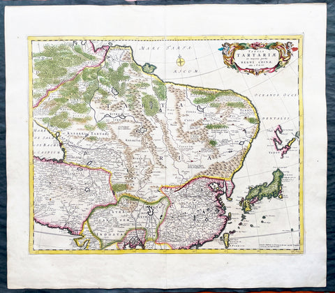
1680 Frederick de Wit Large Antiue Map of Tartary, China, Japan, Mogul, Formosa
Antique Map
- Title : Magnae Tartariae Magni Mogolis Imperii, Japoniae et Chinae...F de Wit
- Ref #: 17030
- Size: 25in x 22 1/2in (635mm x 570mm)
- Date : 1680
- Condition: (A+) Fine Condition
Description:
This large, handsome original hand coloured copper plate engraved antique map of Tartary including China, Japan, Central Asia, parts of the Mogul Empire, Persia and Siberia - was published by Fredrick De Wit in 1680.
The map is finely engraved with detail, with fine original colour on sturdy, strong paper.
General Definitions:
Paper thickness and quality: - Heavy and stable
Paper color : - off white
Age of map color: - Early
Colors used: - Yellow, orange
General color appearance: - Authentic
Paper size: - 25in x 22 1/2in (635mm x 570mm)
Plate size: - 22in x 17 1/2in (560mm x 445mm)
Margins: - Min 1in (25mm)
Imperfections:
Margins: - Light age toning
Plate area: - Light age toning
Verso: - Light age toning
Background:
Although Arabia, Persia, the Silk road to China and those parts of Northern India conquered by Alexander the Great were known to the classical world, it was not until the year AD 1375 that a map giving some idea of the real shape and size of Asia was compiled. This was the famous Catalan Map, based on reports of Franciscan missionaries and the writings of Marco Polo. A century or so later in the first Ptolemaic Atlases, there were altogether twelve maps of Asia which, of course, revealed no more or less than Ptolemy's view of the Ancient world, but in the expanded Waldseemuller editions of 1513 and 1532 there were modern regional maps including much information from Marco Polo's travels.
Later 16th century maps continue to show many of the distorted outlines copied from Ptolemy although by this time India, Ceylon and the Indies were gaining more recognizable shape. Munster was again the first publisher to print a separate map of Asia and later Ortelius issued the first separately printed map of China in 1584 and Japan in 1595. In the next century highly decorative maps were published by Van Den Keere in 1614, Speed 1627, Blaeu 1630, De Wit 1660, Visscher 1680 and others too numerous to list. (Ref: Tooley, M&B)
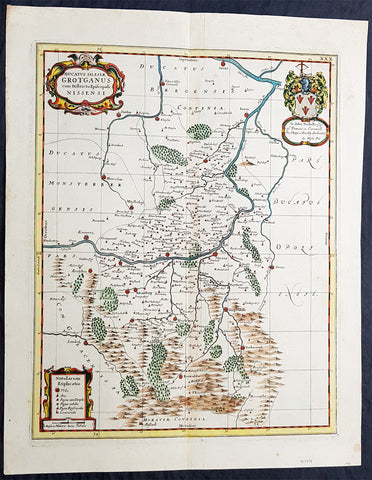
1681 J Jansson & Moses Pitt Rare Antique Map Duchy of Grottkau & Nysa Silesia, Poland
Antique Map
- Title : Ducatus Silesiae Grotganus cum Districtu Episcopali Nissensi
- Ref #: 93485
- Size: 23in x 18in (590mm x 460mm)
- Date : 1681
- Condition: (A+) Fine Condition
Description:
This original rare (not called for in Koeman) hand coloured copper plate engraved antique map of the Duchy of Grottkau and the Diocese of Nysa (Grottkau, Neisse, Brieg and the surrounding area) in the ancient region of Silesia, now in Western Poland by Jan Jansson was published by Moses Pitt in the 1681 edition of Atlas of the World
Moses Pitt 1639–1697 was a bookseller and printer known for the production of his Atlas of the world, a project supported by the Royal Society, and in particular by Christopher Wren. He is also known as the author of The Cry of the Oppressed (1691), an account of the conditions in which imprisoned debtors lived in debtors jails in England.
His work was characterised by its learned content and included authors such as Robert Boyle and Gilbert Burnet. His Atlas was initially intended to be 12 volumes and he continued to undertake other work for the Royal Society. However rising costs, estimated by Pitt at £1000 per volume, contributed to his eventual bankruptcy and only four volumes were ever produced. The second volume had as frontispiece a noted engraved portrait of Queen Catherine of Braganza, by Edward Le Davis.
In Ireland William Molyneux collaborated with Roderic OFlaherty to collect material for the Atlas. While Pitts financial crisis lead to cancellation of the project, much valuable work on early Irish history was collected. Molyneux and OFlaherty struck a friendship and Molyneux assisted when the latters treatise Ogygia was published in London in 1685.
As a result of the Atlas project, Pitt was declared bankrupt. He was taken to the Fleet Prison, and remained there, or in the Kings Bench Prison, for seven years. In 1691, he published The Cry of the Oppressed: Being a True and Tragical Account of the Unparalleld Sufferings of Multitudes of Poor Imprisond Debtors In Most of the Gaols in England, a moving appeal on behalf of prisoners for debt across the country. (Ref: Tooley; M&B)
General Definitions:
Paper thickness and quality: - Heavy and stable
Paper color : - off white
Age of map color: - Original
Colors used: - Blue, pink, red, green, yellow
General color appearance: - Authentic
Paper size: - 23in x 18in (590mm x 460mm)
Plate size: - 20in x 15 3/4in (510mm x 385mm)
Margins: - Min 1in (25mm)
Imperfections:
Margins: - None
Plate area: - None
Verso: - None
Background:
Silesia is a historical region of Central Europe mostly in Poland, with small parts in the Czech Republic and Germany. Its area is approximately 40,000 km2, and the population is estimated at around 8,000,000 inhabitants. Silesia is split into two main sub-regions of Lower Silesia in the west and Upper Silesia in the east. Silesia has a diverse culture, including architecture, costumes, cuisine, traditions, and the Silesian language.
Silesia is along the Oder River, with the Sudeten Mountains extending across the southern border. The region possesses many historical landmarks and UNESCO World Heritage Sites. It is also rich in mineral and natural resources, and includes several important industrial areas. Silesias largest city and historical capital is Wrocław. The biggest metropolitan area is the Upper Silesian metropolitan area, the centre of which is Katowice. Parts of the Czech city of Ostrava and the German city of Görlitz fall within the borders of Silesia.
Silesias borders and national affiliation have changed over time, both when it was a hereditary possession of noble houses and after the rise of modern nation-states. The varied history with changing aristocratic possessions resulted in an abundance of castles, especially in the Jelenia Góra valley. The first known states to hold power in Silesia were probably those of Greater Moravia at the end of the 9th century and Bohemia early in the 10th century. In the 10th century, Silesia was incorporated into the early Polish state, and after its division in the 12th century became a Piast duchy. In the 14th century, it became a constituent part of the Bohemian Crown Lands under the Holy Roman Empire, which passed to the Austrian Habsburg Monarchy in 1526. As a result of the Silesian Wars, the region was annexed by Prussia in 1742.
After World War I, the easternmost part of Upper Silesia was granted to Poland by the Entente Powers after insurrections by Poles and the Upper Silesian plebiscite. The remaining former Austrian parts of Silesia were partitioned to Czechoslovakia, forming part of Czechoslovakias Sudetenland region, and are today part of the Czech Republic. In 1945, after World War II, the bulk of Silesia was transferred to Polish jurisdiction by the Potsdam Agreement between the victorious Allies and became part of Poland, whose Communist government expelled the majority of Silesias previous population. The small Lusatian strip west of the Oder–Neisse line, which had belonged to Silesia since 1815, remained in Germany.
1682 Du Val Original Antique Map of North Pole, North America, Europe, Russia
- Title : Terres Arctiques.. Septemtrional et Boreales.
- Date : 1682
- Size: 6 1/2in x 6in (160mm x 155mm)
- Ref #: 22138
- Condition: (A+) Fine Condition
Description:
This beautifully hand coloured original 1682 antique map of the North Pole by Pierre Du Val was published in his 1682 miniature atlas, 'Géographie Universelle'.Jacques Nicholas Bellindu
General Definitions:
Paper thickness and quality: - Heavy and stable
Paper color : - off white
Age of map color: - Original
Colors used: - Yellow, green, blue, pink
General color appearance: - Authentic
Paper size: - 6 1/2in x 6in (160mm x 155mm)
Plate size: - 5in x 4in (125mm x 100mm)
Margins: - Min 1/2in (12mm)
Imperfections:
Margins: - None
Plate area: - None
Verso: - None
Background:
A driving force for the exploration of the Arctic was the desire of European monarchs to find an alternate trading route to China, via either a Northwest Passage along the coast of North America, or a Northeast Passage along the coast of Siberia. A number of expeditions sought such routes in the 1500-1700s, which resulted in the discovery of much of northern North America, but no viable passage.
In 1524, under the direction of the king of France, Giovanni da Verrazano took the entrance to Hudson River (now New York City) to be the entrance for the passage, and ten years later Jacques Cartier likewise discovered the St. Lawrence estuary. The first Englishman to seek the passage was Martin Frobisher in three voyages up to 60°N between 1576 and 1578. On his first voyage, relations with the natives quickly became hostile, and a prisoner was brought back to England. John Davis followed in 1585, 1586, and 1587 charting the strait west of Greenland that now bears his name.
Financed by the Dutch, in 1609 the Englishman Henry Hudson followed Verrazano's course, and explored the river that now bears his name. The following year he discovered the vast inlet (now called Hudson Bay) beyond Davis Strait. Robert Bylot and navigator William Baffin undertook two expeditions in 1615 and 1616, exploring the north coast of Greenland up to 78°N and then along the Canadian archipelago to Lancaster Sound. Convinced it was only a bay, Baffin concluded that no Northwest Passage existed, and interest in searching for one waned for the next 200 years.
Other explorers were drawn to search for a Northeast Passage connecting the White Sea and Bering Sea. The Dutch navigator William Barents led three expeditions east of Novaya Zemlya, and on the third expedition in 1596 claimed Spitsbergen. From the early 16th century, Russian navigators used shallow draft vessels with reinforced bottoms (kochi) to cross the Kara Sea and explore the Ob and Yenisey rivers. Yermak's Cossacks expanded the Russian presence eastward, crossing the Ural Mountains in 1581. In 1601, Mangazeya town was founded at Taz River between the Ob and Yenisey rivers, and dozens of boats from Pomor lands began annual navigations.
Throughout the first quarter of the 17th century, a great number of merchants, trappers and Cossacks moved east and north, settled East Siberia and explored the northern Siberian coast. In 1610, the Yenisey River was navigated to its northern estuary and the coast to the estuary of the Pyasina was explored. Cape Chelyuskin was overtaken from the west in 1617, Yakutian Cossacks Ivan Rebrov and Ilya Perfilyev headed down to the Lena River estuary and made the first sea voyage to the Yana River in 1633, and in 1639, the Pacific shore was reached by Ivan Moskvitin and his detachment of Cossacks. In a 15-year timespan, all Siberian river estuaries from Khatanga to Kolyma had been discovered and a large part of the Northeast Passage from the White Sea to Kolyma estuary had been covered. Semen Dezhnev traversed the final segment in 1648, leading 90 Cossacks on a journey from the Kolyma to Anadyr Rivers, discovering the strait between Asia and America (proving that they were different continents) and passing the cape which now bears his name.

1682 Merian Antique Map Birds Eye View of the Siege of Szczecin, Stettin Poland
Antique Map
- Title : Abbildung der voortrefflichen Langwerenden Belägerung der Statt und Vöstung Alt Stettin . Im Jahr 1677
- Ref #: 93495
- Size: 15 1/2in x 13 1/2in (395mm x 345mm)
- Date : 1682
- Condition: (A+) Fine Condition
Description:
This original copper-plate engraved antique map a birds-eye view of the siege of Szczecin or Stettin, Poland in 1677 by Matthaus Merian was published in the 1682 edition of Theatrum Europaeum
During the Thirty Years War, Stettin refused to accept German imperial armies, instead the Pomeranian dukes allied with Sweden. After the Treaty of Stettin (1630) manifested Swedish occupation, Stettin was fortified by the Swedish Empire. After the death of the last Pomeranian duke, Boguslaw XIV, Stettin was awarded to Sweden with the western part of the duchy in the Peace of Westphalia (1648), but remained part of the Holy Roman Empire. The Swedish-Brandenburgian border was settled in the Treaty of Stettin (1653). The King of Sweden became Duke of Pomerania and as such held a seat in the Imperial Diet of the Holy Roman Empire. The city was cut off from its main trading area, and was besieged in several wars with Brandenburg which shattered the citys economy, which fell in prolonged economic decline.
In 1654 the last Pomeranian duke Boguslaw XIV was buried in the Ducal Castle.
General Definitions:
Paper thickness and quality: - Heavy and stable
Paper color : - off white
Age of map color: -
Colors used: -
General color appearance: -
Paper size: - 15 1/2in x 13 1/2in (395mm x 345mm)
Plate size: - 11in x 10in (280mm x 255mm)
Margins: - Min 1/2in (12mm)
Imperfections:
Margins: - None
Plate area: - None
Verso: - None
Background:
Szczecin/Stettin is the capital and largest city of the West Pomeranian Voivodeship in northwestern Poland. Located near the Baltic Sea and the German border, it is a major seaport and Polands seventh-largest city.
Szczecin is located on the river Oder, south of the Szczecin Lagoon and the Bay of Pomerania. The city is situated along the southwestern shore of Dąbie Lake, on both sides of the Oder and on several large islands between the western and eastern branches of the river. Szczecin is adjacent to the town of Police and is the urban centre of the Szczecin agglomeration, an extended metropolitan area that includes communities in the German states of Brandenburg and Mecklenburg-Vorpommern.
The cities recorded history began in the 8th century as a Lechitic Pomeranian stronghold, built at the site of the Ducal castle. In the 12th century, when Szczecin had become one of Pomeranias main urban centres, it lost its independence to Piast Poland, the Duchy of Saxony, the Holy Roman Empire and Denmark. At the same time, the House of Griffins established themselves as local rulers and the population was Christianized. After the Treaty of Stettin in 1630, the town came under the control of the Swedish Empire and became in 1648 the Capital of Swedish Pomerania until 1720, when it was acquired by the Kingdom of Prussia and then the German Empire. Following World War II Stettin became part of Poland in accordance with the Potsdam Agreement, resulting in the almost complete expulsion of the pre-war German population.
Merian, Matthaus 1593 - 1650
Merian was a Swiss-born engraver who worked in Frankfurt for most of his career, where he also ran a publishing house. He was a member of the patrician Basel Merian family.
Born in Basel, Merian learned the art of copperplate engraving in Zürich. He next worked and studied in Strasbourg, Nancy, and Paris, before returning to Basel in 1615. The following year he moved to Frankfurt, Germany where he worked for the publisher Johann Theodor de Bry, who was the son of renowned engraver and traveler Theodor de Bry.
In 1617, Merian married Maria Magdalena de Bry, daughter of the publisher, and was for a time associated with the de Bry publishing house. In 1620 they moved back to Basel, but three years later returned to Frankfurt. They had four daughters and three sons, including Matthäus Merian the Younger. Maria Magdalena de Bry died in 1645 and the following year Matthäus married Johanna Catharina Hein. Five years later, Matthäus died, leaving his wife with two small children, Anna Maria Sibylla Merian (born 1647) who later became a pioneering naturalist and illustrator and a son, Maximilian, who died before his third birthday.
In 1623 Merian took over the publishing house of his father-in-law after de Brys death. In 1626 he became a citizen of Frankfurt and could henceforth work as an independent publisher. He spent most of his working life in Frankfurt.
Early in his life, he had created detailed town plans in his unique style, e.g. a plan of Basel (1615) and a plan of Paris (1615). With Martin Zeiler (1589 - 1661), a German geographer, and later (circa 1640) with his own son, Matthäus Merian (der Jüngere, i.e.the Younger or Jr.) (1621 - 1687), he produced a series of Topographia. The 21-volume set was collectively known as the Topographia Germaniae. It includes numerous town plans and views, as well as maps of most countries and a World Map—it was such a popular work that it was re-issued in many editions. He also took over and completed the later parts and editions of the Grand Voyages and Petits Voyages, originally started by de Bry in 1590.
Merians work inspired the Suecia Antiqua et Hodierna by Erik Dahlberg. The German travel magazine Merian is named after him.
He was also noted for the finesse of his alchemical illustrations, in books such as the Musaeum Hermeticum (1678) and Atalanta Fugiens (1618).
Matthäus Merian died after several years of illness in 1650 in Langenschwalbach, near Wiesbaden.
After his death, his sons Matthäus Jr. and Caspar took over the publishing house. They continued publishing the Topographia Germaniae and the Theatrum Europaeum under the name Merian Erben (i.e. Merian Heirs).
1683 Daniel King & William Dugdale Antique Print of Old St Pauls Cathedral London - Pre Great Fire
- Title : Ecclesiae Cathedralis Sti Pauli facies Aquilonaris / The North Prospect of ye Cathedral Church of St Paul in London
- Date : 1683
- Condition: (A+) Fine Condition
- Ref # : 16365
- Size : 15 1/2in x 13 1/2in (395mm x 340mm)
Description:
This fine original copper-pate antique print of the old St Pauls Cathedral London, was engraved by Daniel King prior to the Great Fire of London in 1666 and was published by Sir William Dugdale in the 1683 edition of Monasticon Anglicanum: A History of the Abbies and other Monasteries, Hospitals, Frieries, and Cathedral and Collegiate Churches, with their Dependencies, in England and Wales.
General Definitions:
Paper thickness and quality: - Heavy and stable
Paper color : - off white
Age of map color: -
Colors used: -
General color appearance: -
Paper size: - 15 1/2in x 13 1/2in (395mm x 340mm)
Plate size: - 14 1/2in x 9in (370mm x 230mm)
Margins: - Min 1/2in (12mm)
Imperfections:
Margins: - None
Plate area: - Folds as issued, small repair to bottom of page not affecting the image
Verso: - None
Background: Old St Paul's Cathedral was the medieval cathedral of the City of London that, until 1666, stood on the site of the present St Paul's Cathedral. Built in 1087–1314 and dedicated to Saint Paul, the cathedral was the fourth church on the site at Ludgate Hill. Work began during the reign of William the Conqueror after a fire in 1087 that destroyed much of the city. Work took more than 200 years, and construction was delayed by another fire in 1135. The church was consecrated in 1240 and enlarged again in 1256 and the early 14th century. At its completion in the middle of the 14th century, the cathedral was one of the longest churches in the world and had one of the tallest spires and some of the finest stained glass.
The presence of the shrine of Saint Erkenwald made the cathedral a pilgrimage site during the Medieval period. In addition to serving as the seat of the Diocese of London, the building developed a reputation as a hub of the City of London, with the nave aisle, "Paul's walk", known as a centre for business and the London grapevine. After the Reformation, the open-air pulpit in the churchyard, St Paul's Cross, became the stage for radical evangelical preaching and Protestant bookselling.
The cathedral was already severely in decline by the 17th century. Restoration work by Inigo Jones in the 1620s was halted by the English Civil War. Sir Christopher Wren was attempting another restoration in 1666 when the cathedral was destroyed in the Great Fire of London. After demolition of the old structure, the present, domed cathedral was erected on the site, with an English Baroque design by Wren
Sir William Dugdale 1605-1686 was an English antiquary and herald. As a scholar he was influential in the development of medieval history as an academic subject.
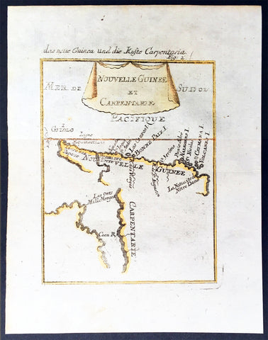
1683 Mallet Antique Map of Australia Cape York Peninsula Gulf of Carpenteria PNG
- Title : Nouvelle Guinee et Carpentarie
- Ref #: 50601
- Size: 8in x 6in (205mm x 152mm)
- Date : 1682
- Condition: (A+) Fine Condition
Description:
This hand coloured original antique very early map of Cape York Peninsula, the Gulf of Carpenteria and New Guinea - depicted before the Torres Strait was charted - was published as part of the 1683 edition of Alain Manesson Mallet's 1630 - 1706 Description de l' Univers.
Background:
The first detailed published map to show any part of Queensland (Tully). Shows New Guinea , the east coast of Cape York Peninsula and part of Arnhem Land.
Although not a particularly large map, the significance of Mallet's map of Carpentaria and New Guinea is underrated. It is essentially the first map to concentrate specifically on the Dutch discoveries in Queensland by Jan Cartenszoon in the Pera and the Arnhem that left Ambon on 21 January 1623 and reached the western side of Cape York Peninsula on 12 April. Although De Jode's rare and famous map 'Novae Guineae Forma & Situs', published almost a century earlier also charts the same area, it shows a fictitious Queensland based on the contemporary beliefs of a 'Terra Australis Incongita', or unknown southland.
Mallet names 'Coen R', one of the rivers discovered and named by Carstensz in 1623. No other Australian place names are shown except 'Carpentarie' on the Cape York Peninsula . Mallet places an interesting reference at the entrance of the Gulf of Carpentaria, "Les onze mille vierges", referring to the eleven thousand virgins of Cologne . A text carved into stone at the Church of Saint Ursula refers to the martyrdom of virgins.
Mallet was a French Engineer who in his early days took service with the Portuguese Army. He later returned to France and served Louis XIV. In 1683 he published Description de l' Univers which contained many hundreds of maps, plans and views. A German edition was published in 1686.
This is a beautifully engraved and hand coloured print in excellent condition. (Ref: Tooley; M&B)
Condition Report
Paper thickness and quality: - Heavy and stable
Paper color: - white
Age of map color: - Early
Colors used: - Yellow, green, blue, red
General color appearance: - Authentic
Paper size: - 8in x 6in (205mm x 152mm)
Plate size: - 6 1/2in x 5in (165mm x 127 mm)
Margins: - min. 1/2in (12mm)
Imperfections:
Margins: - None
Plate area: None
Verso: - None