Products

1745 Tindal Antique Map Battle Plan of Siege of Bouchain, Calais, France in 1711
Antique Map
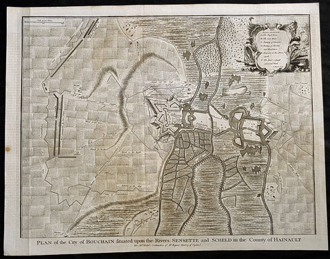
- Title : Plan of the City of Bouchain Situated upon the Rivers Sensette and Scheld in the County of Hainault
- Size: 19 1/2in x 15 1/2in (495mm x 395mm)
- Ref #: 22156-1
- Date : 1745
- Condition: (A+) Fine Condition
Description:
This original copper-plate engraved antique map, battle plan & birds eye view of the French city of Bouchain on the Schedlt River, in the Pas-de-Calais dept. in northern France - during the Spanish War of Succession (1701-13) - was engraved by John Basire and was published in the 1745 edition of Nicholas Tindals Continuation of Mr. Rapin\'s History of England.
General Definitions:
Paper thickness and quality: - Heavy and stable
Paper color : - off white
Age of map color: -
Colors used: -
General color appearance: -
Paper size: - 19 1/2in x 15 1/2in (495mm x 395mm)
Plate size: - 19 1/2in x 15 1/2in (495mm x 395mm)
Margins: - Min 1/2in (12mm)
Imperfections:
Margins: - None
Plate area: - Folds as issued
Verso: - None
Background:
The Siege of Bouchain (9 August – 12 September 1711), following the Passage of the Lines of Ne Plus Ultra (5 August 1711), was a siege of the War of the Spanish Succession, and the last major victory of John Churchill, 1st Duke of Marlborough. Marlborough broke through the French defensive lines and took Bouchain after a siege of 34 days. Its capture left Cambrai the only French-held fortress between the allied army and Paris.
Throughout the early summer of 1711 Marlborough\'s army, having taken the important fortress of Douai the previous year, manoeuvred indecisively in northern France, blocked by the French Lines of Ne Plus Ultra – a massive series of fieldworks stretching from the Channel coast to the Ardennes at Namur. The allied army had been weakened by the withdrawal of Prince Eugene\'s army to cover the upper Rhine, as the deposed Elector of Bavaria attempted to take advantage of the disruption caused by the death of the Emperor Joseph. On 6 July, Marlborough captured the small fortress of Arleux, just to the north of the Lines, west of Bouchain, both to deny its use to the French as a sally-port, and to secure the water supply to Douai, which could be cut off by damming the canal that supplied the town. The Duke was then wrong-footed by Villars as the French army crossed the Lines on 22/23 July and retook Arleux, with the allied army too far to the west to intervene in time, and the defences were levelled before the French retreated back across the Lines. Marlborough, initially furious, soon retook the initiative by marching his army as if to assault the Lines near Arras, and carrying out a detailed personal reconnaissance there on 4 August in full view of Villars\' covering army. That night the army struck camp, leaving their campfires burning to deceive the French, and marched eastwards to Arleux. At midnight a force from Douai under Cadogan crossed the unguarded French lines, and by 8 am the advance guard of the main army was also crossing over. Villars, arriving on the scene with a few hundred cavalry, realised he had been outmanoeuvred, and though he attempted to offer battle in front of Bourlon Wood, Marlborough declined to attack, the Marshal\'s position being even stronger than the one in which he had given Marlborough\'s army such a mauling two years earlier at Malplaquet. He thus drew off and attempted to hinder Marlborough\'s siege of Bouchain which followed.
To defend the town Bouchain\'s governor, de Ravignau, had some 5,000 men against Marlborough\'s besieging army of 30,000, and the advantage of one of the strongest fortresses left to France, surrounded by the marshy land of the confluence of the rivers Scheldt and Sensée. In addition, Villars\' strong army had taken up position to the west of the allied camp, and had managed to open a tenuous link to the besieged garrison. Marlborough responded by using earthwork gun batteries to counter Villars, used a crack assault force managed by 18 August to once more cut the Marshal\'s communication with Bouchain, and established a fieldwork-protected corridor from the siege camp to his main supply port at Marchiennes on the Scarpe. Frequent raids by Villars on both the supply convoys on the Scarpe, and towards Douai, failed to interrupt the siege, and the garrison marched out to become prisoners of war on 13 September 1711.
Bouchain was Marlborough\'s last campaign. On the last day of the year he was stripped of his position as Captain-General, and of all his other offices. Command of the army on the continent for the campaign of 1712 was given to the Duke of Ormonde, and strict limitations were placed on his freedom of movement. Particularly he was prohibited from engaging the French in battle, as Anglo-French peace talks were well advanced, and the opportunity of seizing Cambrai and marching on Paris, opened by Marlborough\'s gains the year before, was abandoned. Before the year was out, the British army would withdraw from the alliance, leaving the remaining allies, under Eugene of Savoy to be defeated at Denain.
1745 Tindal Antique Map Battle Plan of Siege of Bouchain, Calais, France in 1711
Antique Map
- Title : Plan of the City of Bouchain Situated upon the Rivers Sensette and Scheld in the County of Hainault
- Size: 19 1/2in x 15 1/2in (495mm x 395mm)
- Ref #: 22156-1
- Date : 1745
- Condition: (A+) Fine Condition
Description:
This original copper-plate engraved antique map, battle plan & birds eye view of the French city of Bouchain on the Schedlt River, in the Pas-de-Calais dept. in northern France - during the Spanish War of Succession (1701-13) - was engraved by John Basire and was published in the 1745 edition of Nicholas Tindals Continuation of Mr. Rapin\'s History of England.
General Definitions:
Paper thickness and quality: - Heavy and stable
Paper color : - off white
Age of map color: - Early
Colors used: - Pink, blue, green, yellow
General color appearance: - Authentic
Paper size: - 19 1/2in x 15 1/2in (495mm x 395mm)
Plate size: - 19 1/2in x 15 1/2in (495mm x 395mm)
Margins: - Min 1/2in (12mm)
Imperfections:
Margins: - None
Plate area: - Folds as issued
Verso: - None
Background:
The Siege of Bouchain (9 August – 12 September 1711), following the Passage of the Lines of Ne Plus Ultra (5 August 1711), was a siege of the War of the Spanish Succession, and the last major victory of John Churchill, 1st Duke of Marlborough. Marlborough broke through the French defensive lines and took Bouchain after a siege of 34 days. Its capture left Cambrai the only French-held fortress between the allied army and Paris.
Throughout the early summer of 1711 Marlborough\'s army, having taken the important fortress of Douai the previous year, manoeuvred indecisively in northern France, blocked by the French Lines of Ne Plus Ultra – a massive series of fieldworks stretching from the Channel coast to the Ardennes at Namur. The allied army had been weakened by the withdrawal of Prince Eugene\'s army to cover the upper Rhine, as the deposed Elector of Bavaria attempted to take advantage of the disruption caused by the death of the Emperor Joseph. On 6 July, Marlborough captured the small fortress of Arleux, just to the north of the Lines, west of Bouchain, both to deny its use to the French as a sally-port, and to secure the water supply to Douai, which could be cut off by damming the canal that supplied the town. The Duke was then wrong-footed by Villars as the French army crossed the Lines on 22/23 July and retook Arleux, with the allied army too far to the west to intervene in time, and the defences were levelled before the French retreated back across the Lines. Marlborough, initially furious, soon retook the initiative by marching his army as if to assault the Lines near Arras, and carrying out a detailed personal reconnaissance there on 4 August in full view of Villars\' covering army. That night the army struck camp, leaving their campfires burning to deceive the French, and marched eastwards to Arleux. At midnight a force from Douai under Cadogan crossed the unguarded French lines, and by 8 am the advance guard of the main army was also crossing over. Villars, arriving on the scene with a few hundred cavalry, realised he had been outmanoeuvred, and though he attempted to offer battle in front of Bourlon Wood, Marlborough declined to attack, the Marshal\'s position being even stronger than the one in which he had given Marlborough\'s army such a mauling two years earlier at Malplaquet. He thus drew off and attempted to hinder Marlborough\'s siege of Bouchain which followed.
To defend the town Bouchain\'s governor, de Ravignau, had some 5,000 men against Marlborough\'s besieging army of 30,000, and the advantage of one of the strongest fortresses left to France, surrounded by the marshy land of the confluence of the rivers Scheldt and Sensée. In addition, Villars\' strong army had taken up position to the west of the allied camp, and had managed to open a tenuous link to the besieged garrison. Marlborough responded by using earthwork gun batteries to counter Villars, used a crack assault force managed by 18 August to once more cut the Marshal\'s communication with Bouchain, and established a fieldwork-protected corridor from the siege camp to his main supply port at Marchiennes on the Scarpe. Frequent raids by Villars on both the supply convoys on the Scarpe, and towards Douai, failed to interrupt the siege, and the garrison marched out to become prisoners of war on 13 September 1711.
Bouchain was Marlborough\'s last campaign. On the last day of the year he was stripped of his position as Captain-General, and of all his other offices. Command of the army on the continent for the campaign of 1712 was given to the Duke of Ormonde, and strict limitations were placed on his freedom of movement. Particularly he was prohibited from engaging the French in battle, as Anglo-French peace talks were well advanced, and the opportunity of seizing Cambrai and marching on Paris, opened by Marlborough\'s gains the year before, was abandoned. Before the year was out, the British army would withdraw from the alliance, leaving the remaining allies, under Eugene of Savoy to be defeated at Denain.
1745 Tindal Antique Map of France during the Spanish War of Succession 1701-13
- Title : Plan of the Battle of Oudenard fought July 11th 1708
- Size: 19 1/2in x 15 1/2in (495mm x 395mm)
- Ref #: 15661
- Date : 1745
- Condition: (A+) Fine Condition
Description:
This original copper-plate engraved antique map, a battle plan of the Battle of Oudenard or Oudenaarde, in Flemish Belgium, in 1708 between Britain & its allies and France and its allies - during the Spanish War of Succession (1701-13) - was engraved by John Basire and was published in the 1745 edition of Nicholas Tindals Continuation of Mr. Rapin\'s History of England.
General Definitions:
Paper thickness and quality: - Heavy and stable
Paper color : - off white
Age of map color: -
Colors used: -
General color appearance: -
Paper size: - 19 1/2in x 15 1/2in (495mm x 395mm)
Plate size: - 19 1/2in x 15 1/2in (495mm x 395mm)
Margins: - Min 1/2in (12mm)
Imperfections:
Margins: - None
Plate area: - Folds as issued
Verso: - None
Background:
The Battle of Oudenarde (or Oudenaarde) was a battle in the War of the Spanish Succession fought on 11 July 1708 between the forces of Great Britain, the Dutch Republic and the Holy Roman Empire on the one side and those of France on the other. It took place at Oudenaarde (now in Belgium) and was a great victory for the allies.
Great Britain, the Netherlands, and the Holy Roman Empire were horrified at the thought of a union between Spain and France which caused them to ally against France, beginning the War of the Spanish Succession. The commander of the allied armies was John Churchill, 1st Duke of Marlborough, whose chief deputy was the commander of the Empire\'s army Prince Eugène of Savoy, who was his close friend.
Meanwhile, the two French army commanders were very quarrelsome. Louis Joseph, duc de Vendôme was a seasoned, experienced soldier. The Duke of Burgundy had considerably less experience and owed his position to the fact he was the grandson of the King, Louis XIV of France.
Marlborough\'s army consisted of about 80,000 men (113 infantry battalions and 180 cavalry squadrons) just south of Brussels. Eugène\'s forces were assembled at Coblenz. These two areas were somewhat far apart, while the French army\'s 85,000 soldiers (139 battalions and 204 squadrons) were concentrated near Mons.
At this time, the French commanders began quarrelling. Vendôme wanted to attack the city of Huy, which could draw Marlborough in pursuit. The eventual plan adopted, however, (under orders from Louis XIV) was to attack Flanders. The army moved eastward, until they reached the city of Braine-l\'Alleud, which was about 25 km south of Brussels, and also threatened the nearby city of Leuven. Marlborough placed his forces a few miles south of Leuven, in order to cover both threatened cities.
The French army then remained inactive for more than a month. This apparently allowed the extremely behind schedule Eugène to bring his army from the Rhine River. On 5 July, however, the French unexpectedly moved west, taking the cities of Bruges and Ghent (although about 300 British soldiers held out in Ghent for a few days). This extremely demoralized Marlborough and his army, and he did not recover until Eugène was at his side.
The French army had the entire length of the Scheldt River from the French border to the newly taken city of Ghent. Only one British fortress remained: Oudenaarde. If they took that city, Marlborough\'s army would be cut off from the coast, causing them to lose communications with England.
Marlborough detected this objective, and also correctly guessed the method by which the French troops would attempt to take it. They would march down the east bank of the Scheldt (closer to Marlborough\'s troops), while leaving a large covering force between the two opposing armies. The French army marched on 8 July, toward the city of Lessines. However, Marlborough made one of the most inspired forced marches in history, taking the city on 10 July. This forced the French commanders to attempt simply to march across the Scheldt and thereby take the city of Oudenaarde.
Again Marlborough ordered a forced march. This time, though, he ordered 11,000 troops to hold the main crossing point across the Scheldt, under the command of his Quartermaster General, William Cadogan. Cadogan\'s force built 5 additional pontoon bridges to allow Marlborough to get his 80,000-strong army across the river, until French foragers discovered the allied presence around 09:00 AM.
Cadogan, a superb Irish cavalry commander, ordered some dragoons, under Danish General Jørgen Rantzau, to take prisoners from the French advance guard. Many of those troops escaped and alerted Lieutenant General Charles-Armand de Gontaut, duc de Biron, who commanded the vanguard, of the presence of Allied troops on the west bank.
When de Biron advanced, he was disagreeably surprised by the large number of Allied cavalry already across the river, along with the approaching Allied infantry. Although he was ordered to attack by Vendôme, he hesitated upon seeing the reinforced line of 20 battalions (including the four that had been left to guard the pontoon bridges). Biron\'s own forces comprised only 7 battalions and 20 squadrons. He had been given reliable advice that cavalry could not negotiate the marshy terrain in the area and decided not to attempt a crossing. At this time, Eugène, along with 20 squadrons of Prussian cavalry, moved across the river and occupied crucial positions.
While Biron\'s troops were manoeuvring, the leading British infantry brigade had arrived, under the inexperienced but gifted John Campbell, 2nd Duke of Argyll. Cadogan, with authority from Marlborough, attacked Biron\'s 7 battalions (of Swiss mercenaries) with his soldiers (mainly cavalry). The isolated Swiss mercenaries were immediately pushed back and the Allied force destroyed Biron\'s squadrons, until they reached a large mass of French cavalry, at which point they were forced to retire, outnumbered. The force which performed this action was Rantzau\'s cavalry, with the future King George II of England among them.
Burgundy, making another mistake, decided to attack (over protests by Vendôme). The French right wing began to attack the Allied positions near Eine, while the left wing (for an unknown reason) remained stationary near Huise. A very strong position was held by the Allied left wing. 28 cavalry squadrons protected the right flank of Cadogan\'s infantry, which would receive the attack (which proceeded at about 4:00 p.m.).
Burgundy ordered the assault, which landed on Prussian cavalry squadrons under Dubislav Gneomar von Natzmer. Although hard fighting ensued, the attack was dispersed. Then, Vendôme made a dubious decision and led an attack of twelve regiments, fighting hand-to-hand with a half-pike. This meant that while one commander (Burgundy) was in his headquarters, with no view of the battle, the other was fighting, with no possibility of control.
Most historians agree that the weakened Allied right flank would have been destroyed, had the French left wing attacked. Vendôme realized this, asking Burgundy for permission to attack with the left wing. Burgundy sent a messenger with a refusal but the messenger failed to deliver the message. The situation worsened with Vendôme believing that an attack would support his troops, who were lengthening their line, threatening to envelop the Allied left flank. As Argyll\'s regiments approached, they lengthened the Allied line but too slowly and not great enough in extent, to prevent the French from threatening such an envelopment.
Marlborough moved his headquarters to the left flank, giving Eugène command of the right flank (which still checked the left wing of the French army). While the right was under pressure, Marlborough made a brilliant command decision: he placed 18 newly arrived Hessian and Hanoverian battalions in the left flank, while replacing 20 of Prussian General Carl von Lottum\'s battalions, moving them to Eugène\'s support. This moved fresh troops to the critical left, while reinforcing the right flank (and resting Lottum\'s troops). Marlborough then began formulating a new plan of double encirclement. He had the entire Dutch Army, under Field Marshal Count Hendrik Overkirk, an experienced military officer. His force was unable to cross the collapsed pontoon bridges near Oudenaarde, forcing him to use the stone bridges in the city, delaying him for an hour. Marlborough went ahead with his plan, having Eugène\'s cavalry charge towards Burgundy\'s headquarters. The French Household Cavalry, the Maison du Roi, were able to turn them back and Marlborough, with only the 18 Hessian and Hanoverian battalions, was unable to do much other than keep the French right in check. At about 20:30, Overkirk\'s troops had arrived and flanked the French right wing. This was in conjunction with a dual attack by Marlborough and Eugène. Overkirk\'s manoeuvre was successful, with much of the French army being routed or captured but there was not enough daylight to complete the manoeuvre.
The French army retired to Ghent, with its commanders quarreling; only darkness and a few broken pontoon bridges saved the army from destruction. For unknown reasons, about half of the French army was kept in reserve, without participating at all. There was a great mass of French cavalry and infantry in some raised ground north of the Norken River and many of Burgundy\'s troops remained inactive. There were many bad decisions in the French army. The cavalry had remained in reserve, mainly because of the advice that the ground was impassable. The entire left wing (the troops under Burgundy and the large mass north of the Norken) was kept in reserve. They could easily have destroyed the rather weak right wing of the Allied army. Had a concerted attack been carried out, with Vendôme attacking with his main body to envelop the Allied right, while Burgundy attacked with the left (before Overkirk and the rest of Argyll\'s troops arrived), the French army could have easily won. The French army lost about 14–15,000 soldiers (about 8,000 of whom were prisoners) and 25 guns, while the Allies lost fewer than 3,000.
1745 Tindal Antique Map of Spanish & Austrian Armies in Catalonia Spain in 1711
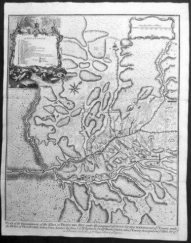
- Title : Plan of the Incampment of the Allies at Prats Del Rey. under the command of Count Staremberg and of ye Enemy under the Duke of Vendsome: wher ye two Armies lay from ye 17th of September to ye 25th of December 1711 N.S. when ye Enemy decamped and ye Allies the 27th.
- Size: 19 1/2in x 15 1/2in (495mm x 395mm)
- Ref #: 15687
- Date : 1745
- Condition: (A+) Fine Condition
Description:
This original copper-plate engraved antique map, a battle plan of the encampments of the Spanish army under Louis-Joseph, duke de Vendome & the Austrian Army under Count Guido Starhemberg in Prado Del Rey in Catalonia, Spain - during the Spanish War of Succession (1701-13) - was engraved by John Basire and was published in the 1745 edition of Nicholas Tindals Continuation of Mr. Rapins History of England.
General Definitions:
Paper thickness and quality: - Heavy and stable
Paper color : - off white
Age of map color: -
Colors used: -
General color appearance: -
Paper size: - 19 1/2in x 15 1/2in (495mm x 395mm)
Plate size: - 19 1/2in x 15 1/2in (495mm x 395mm)
Margins: - Min 1/2in (12mm)
Imperfections:
Margins: - None
Plate area: - Folds as issued
Verso: - None
Background:
Duke Louis-Joseph de Vendome , 1654 — 1712 was one of King Louis XIV’s leading generals during the War of the Spanish Succession (1701–14).
Vendome was the son of Louis de Vendome, Duke de Mercoeur, by his marriage to Cardinal Jules Mazarin’s niece, Laure Mancini. Vendôme entered the French Army in 1672 and had risen to the rank of lieutenant general by the outbreak of the War of the Grand Alliance (1689–97) between France and the other major powers. He distinguished himself in the victory over the Allies at Steenkirke (1692) and was made commander in Catalonia in 1695; two years later he captured Barcelona.
The dispute over the succession to the Spanish throne brought France and Spain to war with the British, the Austrians, and the Dutch in 1701. Appointed to the command in northern Italy in 1702, Vendôme fought the Austrian commander, Prince Eugene of Savoy, in the bloody but indecisive Battle of Luzzara on August 15. He took Vercelli in 1704 and defeated Prince Eugene at Cassano in August 1705. In May 1706 Vendôme was transferred to the Flanders front, where the British commander John Churchill, 1st Duke of Marlborough, had just won an overwhelming victory at Ramillies. Vendôme made limited gains until he was severely defeated by Marlborough and Prince Eugene at Oudenaarde on July 11, 1708. Vendôme subsequently failed to relieve besieged Lille (in northern France), which fell to the Allies in October. Recalled by Louis XIV, he was temporarily disgraced.
Guido Wald Rüdiger, count of Starhemberg1657 – 1737 was an Austrian military officer.
He was a cousin of Ernst Rudiger von Starhemberg (1638-1701), the famous commander of Vienna during the Turkish siege of 1683, and acted as his aide-de-camp during that siege. Guido followed his cousin, and later Prince Eugene of Savoy, in battles against the Turks.
In the War of the Spanish Succession, Starhemberg fought in Italy and Spain. Between 1706 and 1708 he was the commander-in-chief of the imperial army in Hungary, leading military operations against the insurgents of Francis II Rákóczi. In 1708, he was appointed Supreme Commander of the Austrians in Spain.
Together with James Stanhope he succeeded in conquering Madrid in 1710, after previously gaining victories at Almenar and Saragossa. In December, however, he was forced to leave the city by the lack of support by its inhabitants for the Habsburg pretender. After the subsequent defeats at the Battle of Brihuega and the Battle of Villaviciosa (1710), he had to pull back to Catalonia, where he was made viceroy when Archduke Charles returned to Austria.
After the Peace of Utrecht (1713), archduke Charles, now Emperor Charles VI, ordered him to abandon Catalonia. He pulled back with his troops to Genoa on English ships.
When he died in 1737, he was Governor of Slavonia
1745 Tindal Antique Map of Spanish & Austrian Armies in Catalonia Spain in 1711
- Title : Plan of the Incampment of the Allies at Prats Del Rey. under the command of Count Staremberg and of ye Enemy under the Duke of Vendsome: wher ye two Armies lay from ye 17th of September to ye 25th of December 1711 N.S. when ye Enemy decamped and ye Allies the 27th.
- Size: 19 1/2in x 15 1/2in (495mm x 395mm)
- Ref #: 15657
- Date : 1745
- Condition: (A+) Fine Condition
Description:
This original copper-plate engraved antique map, a battle plan of the encampments of the Spanish army under Louis-Joseph, duke de Vendome & the Austrian Army under Count Guido Starhemberg in Prado Del Rey in Catalonia, Spain - during the Spanish War of Succession (1701-13) - was engraved by John Basire and was published in the 1745 edition of Nicholas Tindals Continuation of Mr. Rapins History of England.
General Definitions:
Paper thickness and quality: - Heavy and stable
Paper color : - off white
Age of map color: -
Colors used: -
General color appearance: -
Paper size: - 19 1/2in x 15 1/2in (495mm x 395mm)
Plate size: - 19 1/2in x 15 1/2in (495mm x 395mm)
Margins: - Min 1/2in (12mm)
Imperfections:
Margins: - None
Plate area: - Folds as issued
Verso: - None
Background:
Duke Louis-Joseph de Vendome , 1654 — 1712 was one of King Louis XIV’s leading generals during the War of the Spanish Succession (1701–14).
Vendome was the son of Louis de Vendome, Duke de Mercoeur, by his marriage to Cardinal Jules Mazarin’s niece, Laure Mancini. Vendôme entered the French Army in 1672 and had risen to the rank of lieutenant general by the outbreak of the War of the Grand Alliance (1689–97) between France and the other major powers. He distinguished himself in the victory over the Allies at Steenkirke (1692) and was made commander in Catalonia in 1695; two years later he captured Barcelona.
The dispute over the succession to the Spanish throne brought France and Spain to war with the British, the Austrians, and the Dutch in 1701. Appointed to the command in northern Italy in 1702, Vendôme fought the Austrian commander, Prince Eugene of Savoy, in the bloody but indecisive Battle of Luzzara on August 15. He took Vercelli in 1704 and defeated Prince Eugene at Cassano in August 1705. In May 1706 Vendôme was transferred to the Flanders front, where the British commander John Churchill, 1st Duke of Marlborough, had just won an overwhelming victory at Ramillies. Vendôme made limited gains until he was severely defeated by Marlborough and Prince Eugene at Oudenaarde on July 11, 1708. Vendôme subsequently failed to relieve besieged Lille (in northern France), which fell to the Allies in October. Recalled by Louis XIV, he was temporarily disgraced.
Guido Wald Rüdiger, count of Starhemberg1657 – 1737 was an Austrian military officer.
He was a cousin of Ernst Rudiger von Starhemberg (1638-1701), the famous commander of Vienna during the Turkish siege of 1683, and acted as his aide-de-camp during that siege. Guido followed his cousin, and later Prince Eugene of Savoy, in battles against the Turks.
In the War of the Spanish Succession, Starhemberg fought in Italy and Spain. Between 1706 and 1708 he was the commander-in-chief of the imperial army in Hungary, leading military operations against the insurgents of Francis II Rákóczi. In 1708, he was appointed Supreme Commander of the Austrians in Spain.
Together with James Stanhope he succeeded in conquering Madrid in 1710, after previously gaining victories at Almenar and Saragossa. In December, however, he was forced to leave the city by the lack of support by its inhabitants for the Habsburg pretender. After the subsequent defeats at the Battle of Brihuega and the Battle of Villaviciosa (1710), he had to pull back to Catalonia, where he was made viceroy when Archduke Charles returned to Austria.
After the Peace of Utrecht (1713), archduke Charles, now Emperor Charles VI, ordered him to abandon Catalonia. He pulled back with his troops to Genoa on English ships.
When he died in 1737, he was Governor of Slavonia
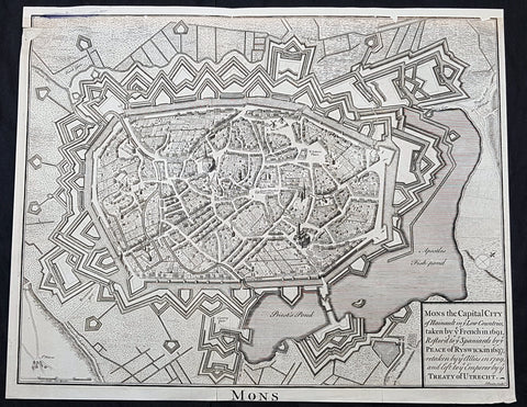
1745 Tindal Original Antique Map Birds Eye View City of Mons, Walloon, Belgium
- Title : Mons the capital city of Hainault in ye French in 1691,restor.d to ye Spaniards by ye Peace of Ryswick in 1697,retaken by ye Allies in 1709 and left to ye Emperor by ye Treaty of Utrecht
- Size: 19 1/2in x 15 1/2in (495mm x 395mm)
- Condition: (A) Very Good Condition
- Date : 1745
- Ref #: 91299
Description:
This original copper-plate engraved antique map a Bird Eye View of the city of Mons, Belgium - during the Spanish War of Succession (1701-13) - was engraved by John Basire and was published in the 1745 edition of Nicholas Tindals Continuation of Mr. Rapins History of England.
General Definitions:
Paper thickness and quality: - Heavy and stable
Paper color : - off white
Age of map color: -
Colors used: -
General color appearance: -
Paper size: - 19 1/2in x 15 1/2in (495mm x 395mm)
Plate size: - 19 1/2in x 15 1/2in (495mm x 395mm)
Margins: - Min 1/2in (12mm)
Imperfections:
Margins: - Top margin restored, smudge along top left border
Plate area: - Small loss to left of image
Verso: - Folds as issued
Background:
Mons is a Walloon city and municipality, and the capital of the Belgian province of Hainaut. The Mons municipality includes the former communes of Cuesmes, Flénu, Ghlin, Hyon, Nimy, Obourg, Jemappes, Ciply, Harmignies, Harveng, Havré, Maisières, Mesvin, Nouvelles, Saint-Denis, Saint-Symphorien, Spiennes and Villers-Saint-Ghislain.
Mons was made into a fortified city by Count Baldwin IV of Hainaut in the 12th century. The population grew quickly, trade flourished, and several commercial buildings were erected near the GrandPlace. In 1814, King William I of the Netherlands increased the fortifications, following the fall of the First French Empire. The Industrial Revolution and coal mining made Mons a center of heavy industry. In 1830, Belgium gained its independence and the decision was made to dismantle the fortifications, allowing the creation of large boulevards and other urban projects.
In 1515, Charles V took an oath in Mons as Count of Hainaut. In this period of its history, the city became the target of various occupations, starting in May 1572 with the Protestant takeover by Louis of Nassau, who had hoped to clear the way for the French Protestant leader Gaspard de Coligny to oppose Spanish rule. After the murder of de Coligny during the St. Bartholomews Day massacre, the Duke of Alba took control of Mons in September 1572 in the name of the Catholic King of Spain. This spelled the ruin of the city and the arrest of many of its inhabitants; from 1580 to 1584, Mons became the capital of the Southern Netherlands.
On 8 April 1691, after a nine-month siege, Louis XIVs army stormed the city, which again suffered heavy casualties. From 1697 to 1701, Mons was alternately French or Austrian. After being under French control from 1701 to 1709, the Dutch army gained the upper hand in the Battle of Malplaquet. In 1715, Mons returned to Austria under the terms of the Treaty of Utrecht (1713). But the French did not give up easily; Louis XV besieged the city again in 1746. After the Battle of Jemappes (1792), the Hainaut area was annexed to France and Mons became the capital of the Jemappes district.
Following the fall of the First French Empire in 1814, King William I of the Netherlands fortified the city heavily. In 1830, however, Belgium gained its independence and the decision was made to dismantle fortified cities such as Mons, Charleroi, and Namur. The actual removal of fortifications only happened in the 1860s, allowing the creation of large boulevards and other urban projects. The Industrial Revolution and coal mining made Mons a center of heavy industry, which strongly influenced the culture and image of the Borinage region as a whole. It was to become an integral part of the sillon industriel, the industrial backbone of Wallonia.
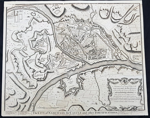
1745 Tindal Original Antique Map Birds Eye View City of Namur, Walloon, Belgium
- Title : The City of Namur with the Castle and other Fortifications
- Size: 19 1/2in x 15 1/2in (495mm x 395mm)
- Condition: (A) Very Good Condition
- Date : 1745
- Ref #: 15970
Description:
This original copper-plate engraved antique map a Bird Eye View of the city of Namur, Belgium - during the Spanish War of Succession (1701-13) - was engraved by John Basire and was published in the 1745 edition of Nicholas Tindals Continuation of Mr. Rapins History of England.
General Definitions:
Paper thickness and quality: - Heavy and stable
Paper color : - off white
Age of map color: -
Colors used: -
General color appearance: -
Paper size: - 19 1/2in x 15 1/2in (495mm x 395mm)
Plate size: - 19 1/2in x 15 1/2in (495mm x 395mm)
Margins: - Min 1/2in (12mm)
Imperfections:
Margins: - Top margin restored
Plate area: - Small loss to left of image
Verso: - Folds as issued
Background:
Mons is a Walloon city and municipality, and the capital of the Belgian province of Hainaut. The Mons municipality includes the former communes of Cuesmes, Flénu, Ghlin, Hyon, Nimy, Obourg, Jemappes, Ciply, Harmignies, Harveng, Havré, Maisières, Mesvin, Nouvelles, Saint-Denis, Saint-Symphorien, Spiennes and Villers-Saint-Ghislain.
Mons was made into a fortified city by Count Baldwin IV of Hainaut in the 12th century. The population grew quickly, trade flourished, and several commercial buildings were erected near the GrandPlace. In 1814, King William I of the Netherlands increased the fortifications, following the fall of the First French Empire. The Industrial Revolution and coal mining made Mons a center of heavy industry. In 1830, Belgium gained its independence and the decision was made to dismantle the fortifications, allowing the creation of large boulevards and other urban projects.
In 1515, Charles V took an oath in Mons as Count of Hainaut. In this period of its history, the city became the target of various occupations, starting in May 1572 with the Protestant takeover by Louis of Nassau, who had hoped to clear the way for the French Protestant leader Gaspard de Coligny to oppose Spanish rule. After the murder of de Coligny during the St. Bartholomews Day massacre, the Duke of Alba took control of Mons in September 1572 in the name of the Catholic King of Spain. This spelled the ruin of the city and the arrest of many of its inhabitants; from 1580 to 1584, Mons became the capital of the Southern Netherlands.
On 8 April 1691, after a nine-month siege, Louis XIVs army stormed the city, which again suffered heavy casualties. From 1697 to 1701, Mons was alternately French or Austrian. After being under French control from 1701 to 1709, the Dutch army gained the upper hand in the Battle of Malplaquet. In 1715, Mons returned to Austria under the terms of the Treaty of Utrecht (1713). But the French did not give up easily; Louis XV besieged the city again in 1746. After the Battle of Jemappes (1792), the Hainaut area was annexed to France and Mons became the capital of the Jemappes district.
Following the fall of the First French Empire in 1814, King William I of the Netherlands fortified the city heavily. In 1830, however, Belgium gained its independence and the decision was made to dismantle fortified cities such as Mons, Charleroi, and Namur. The actual removal of fortifications only happened in the 1860s, allowing the creation of large boulevards and other urban projects. The Industrial Revolution and coal mining made Mons a center of heavy industry, which strongly influenced the culture and image of the Borinage region as a whole. It was to become an integral part of the sillon industriel, the industrial backbone of Wallonia.
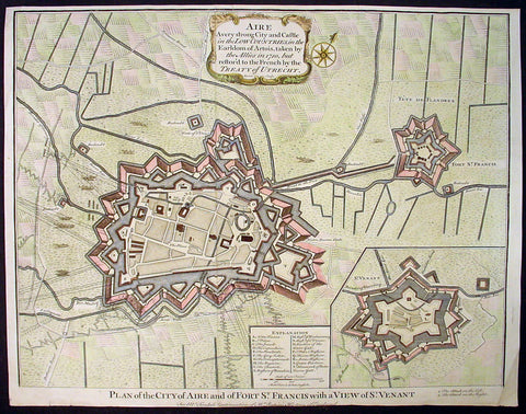
1745 Tindal Original Antique Map of Aire-sur-la-Lys, Fort St Francis & St Venant, France
-
Title : Plan of the City of Aire and Fort of St. Francis with a view of St.Venant
Sep. 28, 1708 - Size: 19 1/2in x 15 1/2in (495mm x 395mm)
- Ref #: 22218
- Date : 1745
- Condition: (A+) Fine Condition
Description:
This beautifully hand coloured original copper-plate engraved antique map, plan & birds eye view of the French city of Aire-sur-la-Lys, a commune in the Pas-de-Calais department in northern France along with Fort St Francis and Fort St Venant - used by Lord Marlborough during the Spanish War of Succession (1701-13) - was engraved by John Basire and was published in the 1745 edition of Nicholas Tindals Continuation of Mr. Rapin\'s History of England.
General Definitions:
Paper thickness and quality: - Heavy and stable
Paper color : - off white
Age of map color: - Early
Colors used: - Pink, blue, green, yellow
General color appearance: - Authentic
Paper size: - 19 1/2in x 15 1/2in (495mm x 395mm)
Plate size: - 19 1/2in x 15 1/2in (495mm x 395mm)
Margins: - Min 1/2in (12mm)
Imperfections:
Margins: - None
Plate area: - Folds as issued
Verso: - None
Background:
Aire-sur-la-Lys is located 10 miles (16 km) southeast of Saint-Omer, by the banks of the Leie and the Laquette rivers.
It is mentioned for the first time in 857 and developed around a fort or castrum built by Baldwin II, Count of Flanders in response to the Norman invasions. More growth followed with the establishment of the Collegiate church of Saint-Pierre by Baldwin V, Count of Flanders.
The town was laid siege ten times between 1127 and 1710. It was separated from the County of Flanders and attached to the County of Artois in 1196. Subsequently ruled by the Burgundians then by the Spanish.
The town was besieged in 1676 by Vauban and retaken for France, although it remained a Spanish possession until 14 April 1713, when, by the Treaty of Utrecht, it finally became a part of France.
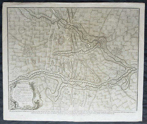
1745 Tindal Original Antique Map Plan of the Battle of Elixheim, Brabant in 1705
- Title : Plan of the Battle lines of Brabant Forced July 18 1705 by the Army of ye Allies commanded by His Grace the Duke of Marlborough & Felt-Marshall D Averquerque Designed upon the spot by Mons D Ivoy Colonel and Quater master General of the Army of the States General
- Size: 19 1/2in x 15 1/2in (495mm x 395mm)
- Ref #: 01-8714
- Date : 1745
- Condition: (A+) Fine Condition
Description:
This original copper-plate engraved antique map, plan of the Battle of Elixheim, in 1705, also known as the Passage of the Lines of Brabant - during the Spanish War of Succession (1701-13) - was engraved by John Basire and was published in the 1745 edition of Nicholas Tindals Continuation of Mr. Rapin\'s History of England.
General Definitions:
Paper thickness and quality: - Heavy and stable
Paper color : - off white
Age of map color: -
Colors used: -
General color appearance: -
Paper size: - 19 1/2in x 15 1/2in (495mm x 395mm)
Plate size: - 19 1/2in x 15 1/2in (495mm x 395mm)
Margins: - Min 1/2in (12mm)
Imperfections:
Margins: - None
Plate area: - None
Verso: - None
Background:
The Battle of Elixheim, 18 July 1705, also known as the Passage of the Lines of Brabant was a battle of the War of the Spanish Succession. The Duke of Marlborough successfully broke through the French Lines of Brabant, an arc of defensive fieldworks stretching in a seventy-mile arc from Antwerp to Namur. Although he was unable to bring about a decisive battle, the breaking and subsequent razing of the lines would prove critical to the allied victory at Ramillies the next year.
Early in the campaigning season, Marlborough attempted to launch an invasion of France up the Moselle valley. This effort was halted by a combination of supply shortages and an excellent French defensive position in front of Sierck, and Marlborough and his army were recalled by the Dutch States General when Marshall Villeroi attacked and took the fortress of Huy and threatened Liege. Having rushed back to the Low Countries (and forcing Villeroi to retreat behind his defenses), Marlborough retook Huy, and then planned to break through the lines to bring Villeroi to battle.
On the evening of 17 July Marlborough sent the Dutch troops under Marshal Overkirk in a feint southwards towards Namur, drawing Villeroi and 40,000 men after them. Overnight he marched with his own English and Scottish troops northwards to the small village of Eliksem (Elixheim), and there broke through the lines without resistance. Early the next day, as Overkirk\'s men countermarched northwards to join with Marlborough, a French detachment attacked the small force of allied troops drawn up to the west of the lines, facing south. Following a short but intense cavalry battle, in which Marlborough was often personally engaged, they were driven off, and Villeroi withdrew his army to the west, behind the river Dyle.
Unable to pursue the French with any vigour on the day of the battle due to the exhaustion of his men, who had marched all night and then fought an intense battle, Marlborough nonetheless still hoped to bring Villeroi to battle. He was frustrated in manoeuvering to the west of the lines in the month immediately following the breakthrough. A final effort in early August, using wagons loaded with supplies to remove his dependency on his lines of communication, while successful in forcing Villeroi\'s army to make a stand close to Waterloo, ultimately failed to bring about a battle due to the veto exercised by the Dutch Field Deputies, notably Slangenburg. The Duke was forced to content himself with the capture of the fortress of Leau and the levelling of the Lines of Brabant between Leau and the Meuse.

1746 Bellin Antique Map The Course of Sangha River, Cameroon & The Congo, Africa
- Title : Cours De La Riviere De Sanaga ou Senegal
- Size: 14in x 10in (360mm x 255mm)
- Ref #: 25554
- Date : 1746
- Condition: (A+) Fine Condition
Description:
This fine large, original copper-plate engraved antique map of the course of the Sangha River flowing through Cameroon & The Congo in Central Africa by Jacques Nicolas Bellin in 1746 was published in Antoine François Prevosts 15 volumes of Histoire Generale des Voyages written by Prevost & other authors between 1746-1790.
General Definitions:
Paper thickness and quality: - Heavy and stable
Paper color : - off white
Age of map color: - Early
Colors used: - Green, Yellow,
General color appearance: - Authentic
Paper size: - 14in x 10in (360mm x 255mm)
Plate size: - 12in x 9 1/2in (305mm x 245mm)
Margins: - Min 1/2in (6mm)
Imperfections:
Margins: - None
Plate area: - Folds as issued
Verso: - None
Background:
One of Antoine Francois Prevosts monumental undertakings was his history of exploration & discovery in 15 volumes titledHistoire Générale des Voyages written between 1746-1759 and was extended to 20 volumes after his death by various authors.
The 20 volumes cover the early explorations & discoveries on 3 continents: Africa (v. 1-5), Asia (v. 5-11), and America (v. 12-15) with material on the finding of the French, English, Dutch, and Portugese.
A number of notable cartographers and engravers contributed to the copper plate maps and views to the 20 volumes including Nicolas Bellin, Jan Schley, Chedel, Franc Aveline, Fessard, and many others.
The African volumes cover primarily coastal countries of West, Southern, and Eastern Africa, plus the Congo, Madagascar, Arabia and the Persian Gulf areas.
The Asian volumes cover China, Korea, Tibet, Japan, Philippines, and countries bordering the Indian Ocean.
Volume 11 includes Australia and Antarctica.
Volumes 12-15 cover voyages and discoveries in America, including the East Indies, South, Central and North America.
Volumes 16-20 include supplement volumes & tables along with continuation of voyages and discoveries in Russia, Northern Europe, America, Asia & Australia.

1746 Bellin Antique Map The Course of Sangha River, Cameroon & The Congo, Africa
- Title : Cours De La Riviere De Sanaga ou Senegal
- Size: 14in x 10in (360mm x 255mm)
- Ref #: 21201
- Date : 1746
- Condition: (A+) Fine Condition
Description:
This fine large, original copper-plate engraved antique map of the course of the Sangha River flowing through Cameroon & The Congo in Central Africa by Jacques Nicolas Bellin in 1746 was published in Antoine François Prevosts 15 volumes of Histoire Generale des Voyages written by Prevost & other authors between 1746-1790.
General Definitions:
Paper thickness and quality: - Heavy and stable
Paper color : - off white
Age of map color: - Early
Colors used: - Green, Yellow,
General color appearance: - Authentic
Paper size: - 14in x 10in (360mm x 255mm)
Plate size: - 12in x 9 1/2in (305mm x 245mm)
Margins: - Min 1/2in (6mm)
Imperfections:
Margins: - None
Plate area: - Folds as issued
Verso: - None
Background:
One of Antoine Francois Prevosts monumental undertakings was his history of exploration & discovery in 15 volumes titledHistoire Générale des Voyages written between 1746-1759 and was extended to 20 volumes after his death by various authors.
The 20 volumes cover the early explorations & discoveries on 3 continents: Africa (v. 1-5), Asia (v. 5-11), and America (v. 12-15) with material on the finding of the French, English, Dutch, and Portugese.
A number of notable cartographers and engravers contributed to the copper plate maps and views to the 20 volumes including Nicolas Bellin, Jan Schley, Chedel, Franc Aveline, Fessard, and many others.
The African volumes cover primarily coastal countries of West, Southern, and Eastern Africa, plus the Congo, Madagascar, Arabia and the Persian Gulf areas.
The Asian volumes cover China, Korea, Tibet, Japan, Philippines, and countries bordering the Indian Ocean.
Volume 11 includes Australia and Antarctica.
Volumes 12-15 cover voyages and discoveries in America, including the East Indies, South, Central and North America.
Volumes 16-20 include supplement volumes & tables along with continuation of voyages and discoveries in Russia, Northern Europe, America, Asia & Australia.
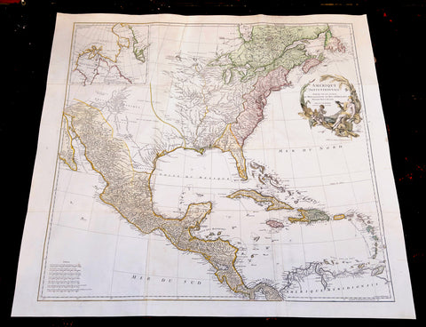
1746 D Anville Large Antique Map of North America - Pre French Indian & Rev. War
Antique Map
-
Title : Amerique Septentrionale Publiee sous les Auspices de Monseigneur le Duc d Orleans.. Par Le Snr. D Anville MDCCXLVI
- Ref #: 17010
-
Condition: (A+) Fine Condition
- Size: 42 1/2in x 37in (1.08m x 940mm)
- Date : 1746
Description:
This large important original copper plate engraved hand coloured antique map of North America, in 12 sheets joined, was engraved in 1746 - dated in the cartouche - and was published by Jean-Baptiste Bourguinon D Anville in his Elephant Folio Atlas Generale.
This map was instrumental in instructing the European Colonial powers of the time, England France & Spain the importance of dominating the New World, that ultimately led to the French and Indian War of 1754–63. This conflict determined the political direction of North America leading to the American War of Independence in 1775 and ultimately the formation of The United States of America.
To illustrate the importance of cartography in the mid eighteenth century, especially that of North America, a J B D Anville map is essential. D Anville dominated 18th century European cartography with many of his cartographical achievements, especially in North America, copied by many of his contemporaries such as Kitchen, Sayer, Homann, Seutter, Mitchell and others .
He was one of the first to leave blank spaces in his maps, where knowledge was scant or insufficient. His representation of the great lakes is superior to that of his contemporary John Mitchell, responsible for publishing one of the most famous mid 18th century maps of North America, A Map of the British and French Dominions in North America on 8 sheets in 1755 and remained the standard map of North America up until the end of the 18th century. (Ref: Tooley, Printed maps of America, 104; The Mapping of America 316)
General Definitions:
Paper thickness and quality: - Heavy and stable
Paper color : - off white
Age of map color: - Original & later
Colors used: - Red, yellow, green, blue
General color appearance: - Authentic
Paper size: - 42 1/2in x 37in (1.08m x 940mm)
Plate size: - 34 1/2in x 33 1/2in (875m x 850mm)
Margins: - Min 1in (25mm)
Imperfections:
Margins: - Small restoration to left margin, not affecting the image
Plate area: - None
Verso: - Age toning
Background:
The French and Indian War (1754–63) comprised the North American theatre of the worldwide Seven Years War of 1756–63. It pitted the colonies of British America against those of New France. Both sides were supported by military units from their parent countries, as well as by American Indian allies. At the start of the war, the French North American colonies had a population of roughly 60,000 settlers, compared with 2 million in the British North American colonies. The outnumbered French particularly depended on the Indians. The European nations declared war on one another in 1756 following months of localized conflict, escalating the war from a regional affair into an intercontinental conflict.
The name French and Indian War is used mainly in the United States. It refers to the two enemies of the British colonists, the royal French forces and their various American Indian allies. The British colonists were supported at various times by the Iroquois, Catawba, and Cherokee, and the French colonists were supported by Wabanaki Confederacy members Abenaki and Mikmaq, and Algonquin, Lenape, Ojibwa, Ottawa, Shawnee, and Wyandot.
British and other European historians use the term the Seven Years War, as do English-speaking Canadians. French Canadians call it La guerre de la Conquête (the War of the Conquest) or (rarely) the Fourth Intercolonial War.
Fighting took place primarily along the frontiers between New France and the British colonies, from Virginia in the south to Newfoundland in the north. It began with a dispute over control of the confluence of the Allegheny River and Monongahela River called the Forks of the Ohio, and the site of the French Fort Duquesne in Pittsburgh, Pennsylvania. The dispute erupted into violence in the Battle of Jumonville Glen in May 1754, during which Virginia militiamen under the command of 22-year-old George Washington ambushed a French patrol.
In 1755, six colonial governors in North America met with General Edward Braddock, the newly arrived British Army commander, and planned a four-way attack on the French. None succeeded, and the main effort by Braddock proved a disaster; he lost the Battle of the Monongahela on July 9, 1755 and died a few days later. British operations failed in the frontier areas of Pennsylvania and New York during 1755–57 due to a combination of poor management, internal divisions, effective Canadian scouts, French regular forces, and Indian warrior allies. In 1755, the British captured Fort Beauséjour on the border separating Nova Scotia from Acadia, and they ordered the expulsion of the Acadians (1755–64) soon afterwards. Orders for the deportation were given by William Shirley, Commander-in-Chief, North America, without direction from Great Britain. The Acadians were expelled, both those captured in arms and those who had sworn the loyalty oath to His Britannic Majesty. Indians likewise were driven off the land to make way for settlers from New England.
The British colonial government fell in the region of modern Nova Scotia after several disastrous campaigns in 1757, including a failed expedition against Louisbourg and the Siege of Fort William Henry; this last was followed by Indians torturing and massacring their British victims. William Pitt came to power and significantly increased British military resources in the colonies at a time when France was unwilling to risk large convoys to aid the limited forces that they had in New France, preferring to concentrate their forces against Prussia and its allies in the European theater of the war. Between 1758 and 1760, the British military launched a campaign to capture the Colony of Canada (part of New France). They succeeded in capturing territory in surrounding colonies and ultimately the city of Quebec (1759). The British later lost the Battle of Sainte-Foy west of Quebec (1760), but the French ceded Canada in accordance with the Treaty of Paris (1763).
The outcome was one of the most significant developments in a century of Anglo-French conflict. France ceded to Great Britain its territory east of the Mississippi. It ceded French Louisiana west of the Mississippi River (including New Orleans) to its ally Spain in compensation for Spains loss to Britain of Florida. (Spain had ceded Florida to Britain in exchange for the return of Havana, Cuba.) Frances colonial presence north of the Caribbean was reduced to the islands of Saint Pierre and Miquelon, confirming Great Britains position as the dominant colonial power in eastern North America.
Please note all items auctioned are genuine, we do not sell reproductions. A Certificate of Authenticity (COA) can be issued on request.
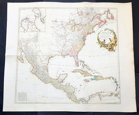
1746 J B D Anville Large Antique Map of North America
- Title : Amerique Septentrionale Publiee sous les Auspices de Monseigneur le Duc d 'Orleans.. Par Le Snr. D Anville MDCCXLVI
- Date : 1746
- Condition: (A+) Fine Condition
- Ref: 93207
- Size: 42 1/2in x 37in (1.08m x 940mm)
Description:
This spectacular large original copper plate engraved antique map of North America by Jean-Baptiste Bourguinon D Anville was in 1746 - dated - and was published in his elphant folio Atlas Generale.
General Definitions:
Paper thickness and quality: - Heavy and stable
Paper color : - off white
Age of map color: - Original & later
Colors used: - Blue, pink, red, green, yellow
General color appearance: - Authentic
Paper size: - 42 1/2in x 37in (1.08m x 940mm)
Plate size: - 34 1/2in x 33 1/2in (875m x 850mm)
Margins: - Min 2in (50mm)
Imperfections:
Margins: - Light spotting in margins
Plate area: - Folds as issued
Verso: - Folds as issued
Background:
To illustrate the cartography of the mid eighteenth century, especially American cartography, a D Anville map is essential. He dominated not only the French but all contemporary European cartography. He was foremost to leave blank spaces in his maps where knowledge was insufficient. His representation of the great lakes is superior to that of his contemporary John Mitchell who was responsible for publishing one of the most famous mid 18th century maps A Map of the British and French Dominions in North America on 8 sheets London in 1755. It was the standard map of North America up until the end of the century.
Eusebio Francisco Kinos discoveries of California in the beginning of the 18th century have now made full impact. D Anvilles map shows California as a peninsula and the Colorado and Gila Rivers are more accurately located. Note that the western part of the Gila River is named the Rio Grande, the Santa Cruz River is called Sta. Maria, and the San Pedro River is Terenate. (Ref: Tooley, Printed maps of America, 104; The Mapping of America 316)
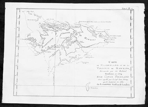
1747 Bellin Antique Map of the Falkland or Maldives Islands Argentina South America
- Title: Carte de Maidenland ou de la Virginie de Hawkins...Richard Hawkins 1574...Cap Jean Strong...1689
- Date: 1747
- Condition : (A+) Fine Condition
- Ref: 35488
- Size: 14in x 10in (360mm x 255mm)
Description:
This fine, original copper-plate engraved antique map of the Falkland Islands by Jacques Nicolas Bellin in 1750 was published in Antoine François Prevosts 15 volumes of Histoire Generale des Voyages written by Prevost & other authors between 1746-1790.
Although Fuegians from Patagonia may have visited the Falkland Islands in prehistoric times, the islands were uninhabited at the time of their discovery by Europeans. Claims of discovery date back to the 16th century, but no consensus exists on whether early explorers discovered the Falklands or other islands in the South Atlantic. The first recorded landing on the islands is attributed to English captain John Strong, who, en route to Peru\'s and Chile\'s littoral in 1690, discovered the Falkland Sound and noted the islands\' water and game.
The Falklands remained uninhabited until the 1764 establishment of Port Louis on East Falkland by French captain Louis Antoine de Bougainville, and the 1766 foundation of Port Egmont on Saunders Island by British captain John MacBride. Whether or not the settlements were aware of each other\'s existence is debated by historians. In 1766, France surrendered its claim on the Falklands to Spain, which renamed the French colony Puerto Soledad the following year. Problems began when Spain discovered and captured Port Egmont in 1770. War was narrowly avoided by its restitution to Britain in 1771.
Both the British and Spanish settlements coexisted in the archipelago until 1774, when Britain\'s new economic and strategic considerations led it to voluntarily withdraw from the islands, leaving a plaque claiming the Falklands for King George III. Spain\'s Viceroyalty of the Río de la Plata became the only governmental presence in the territory. West Falkland was left abandoned, and Puerto Soledad became mostly a prison camp.Amid the British invasions of the Río de la Plata during the Napoleonic Wars in Europe, the islands\' governor evacuated the archipelago in 1806; Spain\'s remaining colonial garrison followed suit in 1811, except for gauchos and fishermen who remained voluntarily.
General Definitions:
Paper thickness and quality: - Heavy and stable
Paper color : - off white
Age of map color: -
Colors used: -
General color appearance: -
Paper size: - 14in x 10in (355mm x 255mm)
Plate size: - 12in x 8in (305mm x 205mm)
Margins: - Min 1/2in (12mm)
Imperfections:
Margins: - None
Plate area: - None
Verso: - None
Background:
One of Antoine Francois Prevosts monumental undertakings was his history of exploration & discovery in 15 volumes titledHistoire Générale des Voyages written between 1746-1759 and was extended to 20 volumes after his death by various authors.
The 20 volumes cover the early explorations & discoveries on 3 continents: Africa (v. 1-5), Asia (v. 5-11), and America (v. 12-15) with material on the finding of the French, English, Dutch, and Portugese.
A number of notable cartographers and engravers contributed to the copper plate maps and views to the 20 volumes including Nicolas Bellin, Jan Schley, Chedel, Franc Aveline, Fessard, and many others.
The African volumes cover primarily coastal countries of West, Southern, and Eastern Africa, plus the Congo, Madagascar, Arabia and the Persian Gulf areas.
The Asian volumes cover China, Korea, Tibet, Japan, Philippines, and countries bordering the Indian Ocean.
Volume 11 includes Australia and Antarctica.
Volumes 12-15 cover voyages and discoveries in America, including the East Indies, South, Central and North America.
Volumes 16-20 include supplement volumes & tables along with continuation of voyages and discoveries in Russia, Northern Europe, America, Asia & Australia.
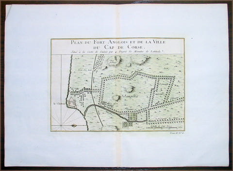
1747 Bellin Antique Map Plan Cape Coast Castle in Ghana West Africa - Slavery
- Title: Plan Du Fort Anglois et de la Ville du Cap De Corse
- Date: 1747
- Condition : (A+) Fine Condition
- Ref: 25657
- Size: 11 1/2in x 11in (295mm x 280mm)
Description:
This beautifully hand coloured original antique map a plan of the Cape Coast Castle - the notorious Slave Castle - situated in the West African country of Ghana was published in 1747 by Jacques Nicolas Bellin for Antoine-François Prevosts 20 volume edition of L`Histoire Generale des Voyages published by Pierre de Hondt, The Hague between 1747 & 1785.
Background: Cape Coast Castle is one of a number of "slave castles", fortifications in Ghana built by Swedish traders, originally for trade in timber and gold, later used in the trans-Atlantic slave trade. Other Ghanaian slave castles include the Portuguese foundation of Elmina Castle (later Dutch) and Fort Christiansborg. They were used to hold slaves before they were loaded onto ships and traded in the Americas and the Caribbean. This “gate of no return” was the last stop before crossing the great Atlantic Ocean (Ref: Tooley; M&B)
General Description:
Paper thickness and quality: - Heavy and stable
Paper color: - off white
Age of map color: - Early
Colors used: - Red, green, yellow
General color appearance: - Authentic
Paper size: - 14in x 10in (380mm x 255mm)
Plate size: - 9in x 6 1/2in (230mm x 165mm)
Margins: - Min 1in (25mm)
Imperfections:
Margins: - None
Plate area: - None
Verso: - None
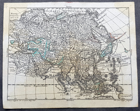
1747 Tobias Lotter Antique Miniature Map of Asia, Gulf of Carpentaria, Australia
Antique Map
- Title : Asia
- Size: 5 1/2in x 4 1/2in (140mm x 115mm)
- Condition: (A) Very Good Condition
- Date : 1747
- Ref #: 93110
Description:
This original copper plate engraved antique miniature map of Asia by Tobias Lotter was published in the 1747 edition of Atlas Geographicus Portatilis XXIX mappis orbis habitabilis regna exhibens.
General Definitions:
Paper thickness and quality: - Heavy and stable
Paper color : - off white
Age of map color: - Original
Colors used: - Green
General color appearance: - Authentic
Paper size: - 5 1/2in x 4 1/2in (140mm x 115mm)
Plate size: - 5 1/2in x 4 1/2in (140mm x 115mm)
Margins: - Min 1/4in (5mm)
Imperfections:
Margins: - Light age toning
Plate area: - Light age toning
Verso: - Light age toning
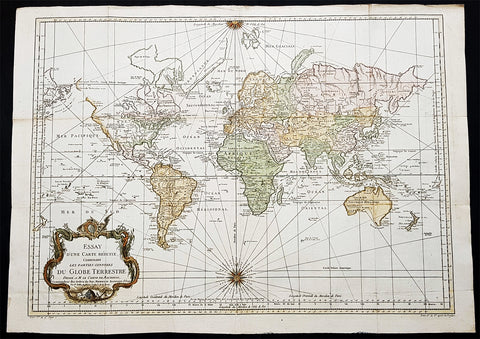
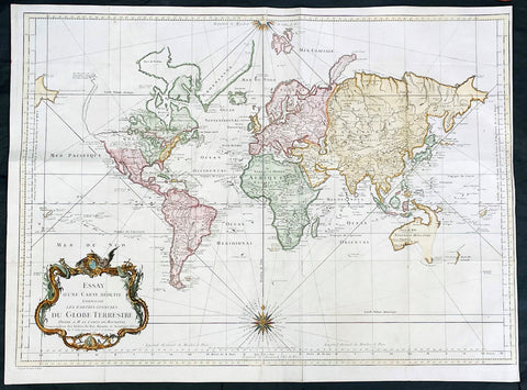
1748 (1770) Nicolas Bellin Large Antique World Map updated by Capt. Cook
Antique Map
- Title : Essay d une Carte Reduite Contenant les parties connuees Du Globe Terrestre...Par N Bellin...1748
- Size: 30 1/2in x 22in (785mm x 560mm)
- Condition: (A+) Fine Condition
- Date : 1748 (1770)
- Ref #: 93353
Description:
This large original copper-plate engraved hand coloured antique World Map, on Mercators Projection, is dated 1748 by Nicolas Bellin, updated showing the discoveries of Captain James Cook in his first voyage of Discovery from 1769-1772.
General Definitions:
Paper thickness and quality: - Heavy and stable
Paper color : - off white
Age of map color: - Early
Colors used: - Yellow, green, blue, orange
General color appearance: - Authentic
Paper size: - 30 1/2in x 22in (785mm x 560mm)
Plate size: - 28 1/2in x 20 1/2in (725mm x 520mm)
Margins: - Min 1in (25mm)
Imperfections:
Margins: - Folds as issued
Plate area: - Folds as issued
Verso: - Folds as issued
Background:
The map presents the entire world on Mercator Projection based on a Paris (LIsle de Fer) meridian, exhibiting post-Cook geography throughout, but most specifically in the Pacific and along the northwest coast of America.
North America to the west of the Mississippi is vaguely rendered according to 16th century expeditions into the region by Coronado, La Salle, De Soto, and others.
Bellin identifies the semi-mythical civilizations of Quivira and Teguayo, both associated with legends of the Seven Cities of Gold, in what is modern day Utah, California, and Nevada. Along the western coast the strait discovered by Martin Aguilar is noted. Further north still the River of the West (Fl. de lOuest) extends from the west coast to the Lake of the Woods (Lac de Bois) and thence via additional waterways to the Great Lakes and the Atlantic. The River of the West appeared in many 18th century maps of the Americas and is reflective of French hopes for a water route from their colonies in Canada and Louisiana to the Pacific. Still further north the coastline becomes extremely vague, in places vanishing altogether. The Aleutians are vaguely rendered according to various sightings by Vitus Jonassen Bering and Aleksei Chirikov in the 1740s and identified as the Archipel de Nord.
In the Pacific, various Polynesian Island groups are noted though many are slightly or significantly misplaced. The Solomon Islands are vastly oversized referencing the early 17th claims of Quiros. The other lands discovered and erroneously mapped by Quiros in 1606 and Davis in 1686 during their search of the great southern continent are also noted. Hawaii, as yet undiscovered, is absent. New Zealand is rendered twice though is accurate in its form and position. Australia, here labeled Nouvelle Holland, has part of its southern coastline ghosted in and Van Diemens Land (Tasmania) is attached to the mainland. The southern coast of New Guinea is similarly ghosted in, suggesting its unexplored state.
It is of interest that there is a common misconception regarding this map that suggests the first edition was dated 1748. There are editions with a printed date of 1748, but these are actually later editions. The 1748 date is a printing error in which 8 and 4 are transposed, the actual date of publication being 1784. The first edition of this map is the 1778 example shown here. (Ref: Tooley; M&B)
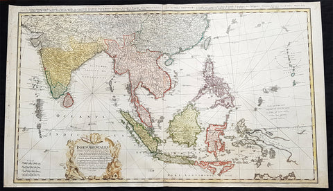
1748 Homann Large Antique Map of Australia, Indonesia, China, SE Asia, India
- Title : Carte Des Indes Orientalis...1748
- Ref #: 93411
- Size: 36 1/4in x 21 1/4in (920mm x 540mm)
- Date : 1748
- Condition: (A+) Fine Condition
Description:
This very large original hand coloured copper plate engraved antique map map of India, SE Asia, The East Indies, Philippines, New Guinea & Australia was engraved by Sebastian Dorn in 1748, dated, and published by the Homann firm.
General Definitions:
Paper thickness and quality: - Light and stable
Paper color : - off white
Age of map color: - Original
Colors used: - Yellow, green, blue, pink
General color appearance: - Authentic
Paper size: - 36 1/4in x 21 1/4in (920mm x 540mm)
Plate size: - 35 1/2in x 20 1/2in (900mm x 515mm)
Margins: - Min 1/2in (12mm)
Imperfections:
Margins: - Light soiling
Plate area: - None
Verso: - Light soiling
Background:
The map is based upon the sea charts created by Jean-Batiste de Mannevillette (1707-80), for the first edition of his Le Neptune Oriental, the first sea atlas of Asian Waters. Mannevillette apprenticed under the great royal cartographer Guillaume De L\'Isle. He then joined the maritime service of the Compagnie des Indes, eventually attaining the rank of captain. Upon his return to Paris, Mannevillette was appointed as director of the Dépôt des Cartes et Plans de la Navigation des Indes.
In 1745, Manneveillette published the first edition of his sea atlas of Asian waters, Le Neptune Oriental. The high quality of Mannevillette\'s charts won him the acclaim of both mariners and academics alike, and he was admitted as a fellow of the Academy of Sciences. He published a second, heavily revised, edition of the Neptune Oriental in 1775.
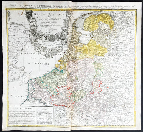
1748 Homann, Mayer Large Old, Antique Map of The Netherlands, Belgium, Holland
- Title : Belgii Universi seu Inferioris Germaniae quam XVII Provinciae Austriaco, Gallico et Batavo sceptro parentes constituunt nova Tabula Geographica a Tobia Majero Math. Cult. ad leges legitimae delineationis revocata Cura et studio Homanniorum Heredum A. 1748
- Ref #: 16422
- Size: 21 1/2in x 20in (545mm x 510mm)
- Date : 1748
- Condition: (A) Very Good Condition
Description:
This large beautifully hand coloured original antique map* of Holland, The Netherlands and Belgium was engraved in 1748 byJohann Tobias Mayer - dated in Title - and was published by Homann firm in 1750.
Background: A beautifully detailed 1748 Homann Heirs map of Belgium and the Netherlands (Holland). Includes Belgium proper as well as the seven states of the Belgian Federation – what is today Holland or the Netherlands. Also includes parts of England and extends into eastern Germany past the Rhine River.
Title elaborate cartouche in the upper left quadrant, filling the North Sea, features the armorial shields of the Belgian Counties as well as those of the seven states of the federation: Geldern, Holland, Zeeland, Utrecht, Friesland, Ober Issel, and Groningen.
This map was drawn by Johann Tobias Mayer for inclusion the 1752 Homann Heirs Maior Atlas Scholasticus ex Triginta Sex Generalibus et Specialibus…. Most early Homann atlases were 'made to order' or compiled of individual maps at the request of the buyer. However, this rare atlas, composed of 37 maps and charts, was issued as a 'suggested collection' of essential Homann Heirs maps. (Ref: Tooley; M&B)
General Description:
Paper thickness and quality: - Heavy and stable
Paper color: - off white
Age of map color: - Original
Colors used: - Yellow, green, blue, pink
General color appearance: - Authentic
Paper size: - 21 1/2in x 20in (545mm x 510mm)
Plate size: - 21in x 19 1/2in (535mm x 495mm)
Margins: - Min 1/2in (12mm)
Imperfections:
Margins: - None
Plate area: - Light creasing along centrefold
Verso: - Re-enforced along centrefold
1748 J N Bellin Large Antique World Map on Mercators Projection - 27007
Antique Map
- Title : Essay d une Carte Reduite Contenant les parties connuees Du Globe Terrestre...1748
- Date : 1748
- Size: 28 1/2in x 21in (725mm x 535mm)
- Condition: (A) Very Good Condition
- Ref: 27007
Description:
This large original hand coloured copper-plate engraved antique World Map, on Mercators Projection was engraved in 1748 by Jacques Nicolas Bellin - dated in the title.
General Definitions:
Paper thickness and quality: - Heavy and stable
Paper color : - off white
Age of map color: - Early
Colors used: - Blue, yellow, green, pink
General color appearance: - Authentic
Paper size: - 28 1/2in x 21in (725mm x 535mm)
Plate size: - 26in x 20 1/2in (710mm x 520mm)
Margins: - Min 1/4in (5mm)
Imperfections:
Margins: - Bottom left margin extended from plate -mark
Plate area: - Folds as issued
Verso: - Folds as issued
Background:
First edition of Bellins large mid-18th century world map, published in Paris. This map pre-dates the major world discoveries of the late 18th century including the North West coast of America, the Sandwich Islands, and the Voyages of Capt Cook soon to map the East Coast of Australia & NZ.
This edition is most noteworthy for its marvelous early projection of Australia and New Zealand, each with largely speculative coastlines. Australia is still attached to New Guinea and has several notes of early exploration shown. New Zealand is barely known and with only a portion of its western coastline.
No sign of Antarctica and the NW Coast of America includes the first notes of Russian exploration.
In North America Bellin identifies the semi-mythical civilizations of Quivira and Teguayo, both associated with legends of the Seven Cities of Gold, in what is modern day Utah, California, and Nevada. Along the western coast the strait discovered by Martin Aguilar is noted. Further north still the River of the West (Fl. de l’Ouest) extends from the west coast to the Lake of the Woods (Lac de Bois) and thence via additional waterways to the Great Lakes and the Atlantic. The River of the West appeared in many 18th century maps of the Americas and is reflective of French hopes for a water route from their colonies in Canada and Louisiana to the Pacific. Still further north the coastline becomes extremely vague, in places vanishing altogether. The Aleutians are vaguely rendered according to various sightings by Vitus Jonassen Bering and Aleksei Chirikov in the 1740s and identified as the “Archipel de Nord”.
In the Pacific, various Polynesian Island groups are noted though many are slightly or significantly misplaced. The Solomon Islands are vastly oversized referencing the early 17th claims of Quiros. The other lands discovered and erroneously mapped by Quiros in 1606 and Davis in 1686 during their search of the great southern continent are also noted. Hawaii, as yet undiscovered, is absent. New Zealand is rendered twice though is accurate in its form and position. Australia, here labelled “Nouvelle Holland”, has part of its southern coastline ghosted in and Van Diemen’s Land (Tasmania) is attached to the mainland. The southern coast of New Guinea is similarly ghosted in, suggesting its unexplored state. (Ref: Tooley; M&B)
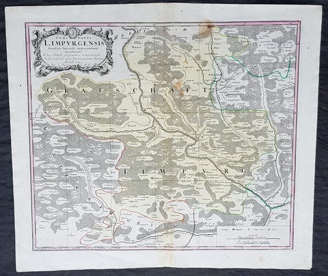
1749 Homann Antique Map Limpurg County, Schwabisch-Hall Baden-Wurtemberg Germany
- Title : Comitatus Limpurgensis Mandato Speciali imperantium mensuratus & hac Tabula geographica comprehensus / In lucem prodit Curis Homannianorum Heredum / Norimb 1749
- Date : 1749
- Condition: (A+) Fine Condition
- Ref: 20428
- Size: 23 1/2in x 20in (595mm x 510mm)
Description:
This large original copper-plate engraved antique map of Limpurg County in the district of Schwäbisch-Hallin in the state of Baden-Wurtemberg, SW Germany by the Homann Heirs was engraved in 1749 - dated in cartouche - and published in the Homanns 1750 German Atlas.
Limpurg is situated in the present-day district of Schwäbisch-Hall or Ostalbkreis between Schwäbisch-Hall, Schwäbisch Gmünd, Aalen and Ellwangen.
The map centers on the river Kocher, with towns marked such as Schwäbisch-Hall (Comburg), Gaildorf, Abstgemünd and Bühlertann.
General Definitions:
Paper thickness and quality: - Heavy and stable
Paper color : - off white
Age of map color: - Original
Colors used: - Yellow, Green, pink
General color appearance: - Authentic
Paper size: - 23 1/2in x 20in (595mm x 510mm)
Plate size: - 21in x 18in (535mm x 460mm)
Margins: - Min 1/4in (5mm)
Imperfections:
Margins: - None
Plate area: - Light soiling
Verso: - None
Background:
Baden-Württemberg is formed from the historical territories of Baden, Prussian Hohenzollern, and Württemberg, and also parts of Swabia.
In 100 AD, the Roman Empire invaded and occupied Württemberg, constructing a limes (fortified boundary zone) along its northern borders. Over the course of the third century AD, the Alemanni forced the Romans to retreat west beyond the Rhine and Danube rivers. In 496 AD the Alemanni were defeated by a Frankish invasion led by Clovis I.
The Holy Roman Empire was later established. The majority of people in this region continued to be Roman Catholics, even after the Protestant Reformation influenced populations in northern Germany. In the late-nineteenth and early-twentieth centuries, numerous people emigrated from this mostly rural area to the United States for economic reasons.
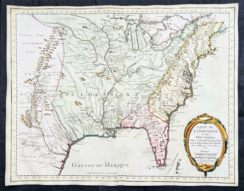
1750 (1755) Nicolas Bellin Very Scarce Large Antique Map of North America
Antique Map
- Title : Carte de La Louisiane et Des Pays Voisins Dediee a M. Rouille Secretairr 'd Etat ayant le Departement de la Marine . . . 1750 . . . Sur de Nouvelle Observations on a corrigee les Lacs, et leurs Enviorns. 1755.
- Date : 1750 (1755)
- Size: 25in x 19 1/2in (635mm x 495mm)
- Condition: (A) Very Good Condition
- Ref: 35661
Description:
This large original very scarce hand coloured copper-plate engraved antique map of North America by Nicolas Bellin, in 1750 - dated - and updated in 1755, was published as a single map by Nicolas Bellin in Paris.
Extremely important, large and scarce 1755 map of North America issued at the outbreak of the French and Indian War (1754 - 1763). Centered on the vast Mississippi Valley, the map covers from the Rio Grande to the Atlantic Seaboard and from Lake Superior to the Florida Keys. While first issued in 1750, the present map has been updated considerably to represent French, English, and Spanish claims at the outbreak of the French and Indian War. Most of the most important battle sites are forts are noted, including Fort Duquesne, Fort Necessity, Fr. Le Boeuf, Fort Presqu'Isle, and Fort St. Frederic, among others.
General Definitions:
Paper thickness and quality: - Heavy and stable
Paper color : - off white
Age of map color: - Early & later
Colors used: - Green, yellow, pink
General color appearance: - Authentic
Paper size: - 25in x 19 1/2in (635mm x 495mm)
Plate size: - 25in x 19 1/2in (635mm x 495mm)
Margins: - Min 1/2in (12mm)
Imperfections:
Margins: - None
Plate area: - Small professional restoration in GOM
Verso: - None
Background:
The map presents the much of the modern United States as the French understood it at the outbreak of the war. Spanish territory is red, English territory is yellow, and French territory is green. The British are here restricted to the coastal lands east of the Appalachian Mountains, and bounded on the south by the Altamaha River, which forms the boundary with Spanish Florida. French Territorial claims are expansive, encompassing roughly 2/3rds of the land and controlling the most valuable waterways, including the Great Lakes, the Ohio, and the Mississippi. Forts, mission settlements, mines, and trading posts dot the Mississippi Valley, but in truth, most of these were, by this time, only loosely manned or altogether abandoned - hardly an argument for effective occupation.
This map features a wealth of cartographic information drawn in part from the Guilaume de L'Isle map of 1718, but has been expanded considerably with new information from the the Chaussegros de Lery manuscripts and Pierre-Francois-Xavier de Charlevoix s Histoire et description generale de la Nouvelle France. Of note is the curious mountain range running through Michigan.
The inclusion of Fort Necessity is significant, as it suggests this map was issued just months after the construction of the fort and George Washington's disastrous defeat there. It underscores how quickly information moved - even through the outback of the New World and active war. For this map to have been made, news of the events, as well as cartographic reconnaissance, would have had to move rapidly from Fort Duquesne, down the Ohio River, then down the full length of the Mississippi, then across the Atlantic to Paris. There Bellin would have had to study the work, reconcile it with his older maps, update and re-engrave them accordingly, and then get the map to the presses for distribution. The whole is a remarkable accomplishment, but may explain somewhat this maps scarcity, as in a short time, much of the data he would be irreverent.
The map is dedicated to Antoine-Louis Rouillé, comte de Jouy (1689 - 1761). Rouillé replaced Jean-Frédéric Phélypeaux, 1st Count of Maurepas (1701 - 1781), Bellin's former patron, as Secretary of State for the Navy (Ministère de la Marine) on July 24, 1754, just in time for the French and Indian War. Bellin, who worked under the Navy Department, would have been highly motivated to engender Rouillé patronage and good well, making the dedication unsurprising.
The map was separately published in Paris, France by Jacques-Nicolas Bellin. It is dedicated to M. Rouillé. It represents the second state of the map, 1755, issued during the French and Indian War. Examples are extremely scarce. We have identified only three examples, including this map, in the last 20 years of market history. The map is further not identified in Cumming, Karpinski, Ehrenberg, or Phillips. The OCLC notes examples in 8 institutions, but upon closer inspection many of these appear to be digital resources and do not represent any actual holdings.
Please note all items auctioned are genuine, we do not sell reproductions. A Certificate of Authenticity (COA) can be issued on request.
1750 Bellin & Condamine Antique Map The Course of the Amazon River South America
- Title : Carte Du Cours Du Maragnon ou De La Grande Riviere Des Amazones...1743 et 1744...par M de la Condamine
- Ref: 50686
- Size: 15in x 10in (380mm x 255mm)
- Date : 1750
- Condition: (A) Very Good Condition
Description:
This finely engraved original antique map of the course of the Amazon River - according to the discoveries of the French explorer Charles-Marie La Condamine - by Jacques Nicolas Bellin in 1750 was published in Antoine-François Prevost's monumental 20 volume edition of L`Histoire Generale des Voyages published by Pierre de Hondt, The Hague between 1747 & 1780.
Charles-Marie La Condamine (1701 - 1774) was a French mathematician and surveyor who took part in an expedition to South America to measure a degree of latitude.
La Condamine was born in Paris. He was trained for the military profession, but turned his attention to science and geographical exploration. After taking part in a scientific expedition in the Levant (1731), he became a member with Louis Godin and Pierre Bouguer of the expedition sent to Peru in 1735 to determine the length of a degree of the meridian in the neighborhood of the equator.
His associations with his principals were unhappy; the expedition was beset by many difficulties, and finally La Condamine separated from the rest and made his way from Quito down the Amazon, ultimately reaching Cayenne. His was the first scientific exploration of the Amazon. He returned to Paris in 1744 and published the results of his measurements and travels with a map of the Amazon in M' de l'Acadme des Sciences, 1745 (English translation 1745-1747). This included the first descriptions by a European of the Casiquiare canal and the curare arrow poison prepared by the Amerindians.
(Ref: Tooley; M&B)
General Description:
Paper thickness and quality: - Heavy and stable
Paper color: - off white
Age of map color: -
Colors used: -
General color appearance: -
Paper size: - 15in x 10in (380mm x 255mm)
Plate size: - 15in x 10in (380mm x 255mm)
Margins: - Min 0in (0mm)
Imperfections:
Margins: - Margins cropped to margins
Plate area: - Folds as issued
Verso: - None
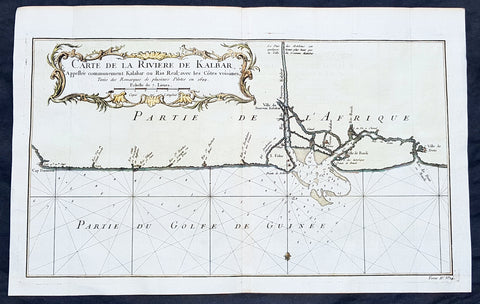
1750 Bellin Antique Map Calabar River, Calabar, Nigeria West Africa - Salve Port
- Title: Carte De la Riviere De Kalbar...Pilotes en 1699
- Date: 1750
- Condition : (A+) Fine Condition
- Ref: 25652
- Size: 16in x 10in (405mm x 255mm)
Description:
This fine large, original copper-plate engraved antique map of Calabar River Mouth, Calabar City in Nigeria, West Africa - a significant slave port of the 17th & 18th centuries - by Jacques Nicolas Bellin in 1750 was published in Antoine François Prevosts 15 volumes of Histoire Generale des Voyages written by Prevost & other authors between 1746-1790.
Detailed coastal map of Guinea coast of Western Africa, is based upon the 1699 voyage of James Barbot & John Grazilhier to New Calabar, Bandi, and Doni Rivers.
Barbot and Grazilhier each gave famous accounts of their experiences in the slave trade in the second half of the 17th Century.
General Definitions:
Paper thickness and quality: - Heavy and stable
Paper color : - off white
Age of map color: - Early
Colors used: - Green, Yellow,
General color appearance: - Authentic
Paper size: - 14in x 10in (355mm x 255mm)
Plate size: - 10 1/4in x 7 1/2in (260mm x 195mm)
Margins: - Min 1/2in (6mm)
Imperfections:
Margins: - None
Plate area: - Folds as issued
Verso: - None
Background:
One of Antoine Francois Prevosts monumental undertakings was his history of exploration & discovery in 15 volumes titledHistoire Générale des Voyages written between 1746-1759 and was extended to 20 volumes after his death by various authors.
The 20 volumes cover the early explorations & discoveries on 3 continents: Africa (v. 1-5), Asia (v. 5-11), and America (v. 12-15) with material on the finding of the French, English, Dutch, and Portugese.
A number of notable cartographers and engravers contributed to the copper plate maps and views to the 20 volumes including Nicolas Bellin, Jan Schley, Chedel, Franc Aveline, Fessard, and many others.
The African volumes cover primarily coastal countries of West, Southern, and Eastern Africa, plus the Congo, Madagascar, Arabia and the Persian Gulf areas.
The Asian volumes cover China, Korea, Tibet, Japan, Philippines, and countries bordering the Indian Ocean.
Volume 11 includes Australia and Antarctica.
Volumes 12-15 cover voyages and discoveries in America, including the East Indies, South, Central and North America.
Volumes 16-20 include supplement volumes & tables along with continuation of voyages and discoveries in Russia, Northern Europe, America, Asia & Australia.
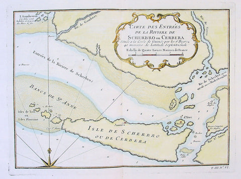
1750 Bellin Antique Map Mouth of the Sherboro River in Seirra Leone, Africa
- Title: Carte des Entrees de la Riviere de Scherbro ou Cerbera
- Date: 1750
- Condition : (A+) Fine Condition
- Ref: 25679
- Size: 14in x 10in (355mm x 255mm)
Description:
This fine large, original copper-plate engraved antique map of the mouth of the Sherboro River in Sierra Leone, Africa by Jacques Nicolas Bellin in 1750 was published in Antoine François Prevosts 15 volumes of Histoire Generale des Voyages written by Prevost & other authors between 1746-1790.
General Definitions:
Paper thickness and quality: - Heavy and stable
Paper color : - off white
Age of map color: - Early
Colors used: - Green, Yellow,
General color appearance: - Authentic
Paper size: - 14in x 10in (355mm x 255mm)
Plate size: - 10 1/4in x 7 1/2in (260mm x 195mm)
Margins: - Min 1/2in (6mm)
Imperfections:
Margins: - None
Plate area: - Folds as issued
Verso: - None
Background:
One of Antoine Francois Prevosts monumental undertakings was his history of exploration & discovery in 15 volumes titledHistoire Générale des Voyages written between 1746-1759 and was extended to 20 volumes after his death by various authors.
The 20 volumes cover the early explorations & discoveries on 3 continents: Africa (v. 1-5), Asia (v. 5-11), and America (v. 12-15) with material on the finding of the French, English, Dutch, and Portugese.
A number of notable cartographers and engravers contributed to the copper plate maps and views to the 20 volumes including Nicolas Bellin, Jan Schley, Chedel, Franc Aveline, Fessard, and many others.
The African volumes cover primarily coastal countries of West, Southern, and Eastern Africa, plus the Congo, Madagascar, Arabia and the Persian Gulf areas.
The Asian volumes cover China, Korea, Tibet, Japan, Philippines, and countries bordering the Indian Ocean.
Volume 11 includes Australia and Antarctica.
Volumes 12-15 cover voyages and discoveries in America, including the East Indies, South, Central and North America.
Volumes 16-20 include supplement volumes & tables along with continuation of voyages and discoveries in Russia, Northern Europe, America, Asia & Australia.
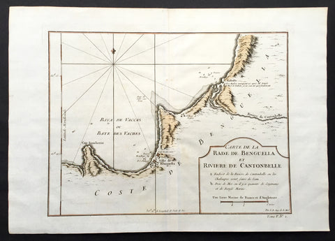
1750 Bellin Antique Map of the Benguela province of Angola, Africa
- Title: Carte de la Rade de Benguella et Riviere de Cantonbelle
- Date: 1750
- Condition : (A+) Fine Condition
- Ref: 25550
- Size: 11 1/2in x 11in (295mm x 280mm)
Description:
This fine large, original copper-plate engraved antique map of the Benguela province of Angola by Jacques Nicolas Bellin in 1750 was published in Antoine François Prevosts 15 volumes of Histoire Generale des Voyageswritten by Prevost & other authors between 1746-1790.
The Portuguese crown created the Kingdom of Benguela in 1615 to improve the conditions to develop the desired land route to Mozambique across Africa. The trading post founded here did not meet the expectations of the Portuguese in mineral resources and soil quality, so a village was only established for the slave trade, under the name of Mbaka
General Definitions:
Paper thickness and quality: - Heavy and stable
Paper color : - off white
Age of map color: - Early
Colors used: - Green, Yellow,
General color appearance: - Authentic
Paper size: - 14in x 10in (355mm x 255mm)
Plate size: - 12in x 9in (305mm x 230mm)
Margins: - Min 1/2in (6mm)
Imperfections:
Margins: - None
Plate area: - Folds as issued
Verso: - None
Background:
One of Antoine Francois Prevosts monumental undertakings was his history of exploration & discovery in 15 volumes titledHistoire Générale des Voyages written between 1746-1759 and was extended to 20 volumes after his death by various authors.
The 20 volumes cover the early explorations & discoveries on 3 continents: Africa (v. 1-5), Asia (v. 5-11), and America (v. 12-15) with material on the finding of the French, English, Dutch, and Portugese.
A number of notable cartographers and engravers contributed to the copper plate maps and views to the 20 volumes including Nicolas Bellin, Jan Schley, Chedel, Franc Aveline, Fessard, and many others.
The African volumes cover primarily coastal countries of West, Southern, and Eastern Africa, plus the Congo, Madagascar, Arabia and the Persian Gulf areas.
The Asian volumes cover China, Korea, Tibet, Japan, Philippines, and countries bordering the Indian Ocean.
Volume 11 includes Australia and Antarctica.
Volumes 12-15 cover voyages and discoveries in America, including the East Indies, South, Central and North America.
Volumes 16-20 include supplement volumes & tables along with continuation of voyages and discoveries in Russia, Northern Europe, America, Asia & Australia.
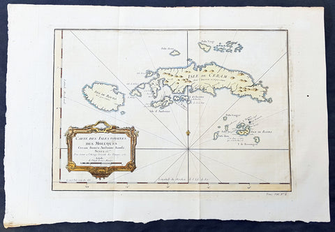
1750 Bellin Original Antique Map The Maluku or Moluccas, Spice Islands Indonesia
- Title : Carte Des Isles Voisines Des Moluques Ceram, Bouro, Amboine, Banda, Neyra....1750
- Ref #: 34099
- Size: 16in x 10 1/2in (390mm x 265mm)
- Date : 1750
- Condition: (A+) Fine Condition
Description:
This fine, original copper-plate engraved antique map of the Maluku or Moluccas Islands (Spice Islands) Indonesia by Jacques Nicolas Bellin in 1750 was published in Antoine François Prevosts 15 volumes of Histoire Generale des Voyages written by Prevost & other authors between 1746-1790.
The Maluku Islands or the Moluccas are an archipelago within Banda Sea, Indonesia. Geographically they are located east of Sulawesi, west of New Guinea, and north and east of Timor.
The islands were known as the Spice Islands due to the nutmeg, mace and cloves that were originally exclusively found there, and the presence of these sparked colonial interest from Europe in the 16th century.
The most significant lasting effects of the Portuguese colonisation was the disruption and reorganization of the Southeast Asian trade, and in eastern Indonesia—including Maluku—the introduction of Christianity. The Portuguese had conquered the city state of Malacca in the early 16th century and their influence was most strongly felt in Maluku and other parts of eastern Indonesia. After the Portuguese annexed Malacca in August 1511, one Portuguese diary noted \'it is thirty years since they became Moors - giving a sense of the competition then taking place between Islamic and European influences in the region.
Afonso de Albuquerque learned of the route to the Banda Islands and other \'Spice Islands\', and sent an exploratory expedition of three vessels under the command of António de Abreu, Simão Afonso Bisigudo and Francisco Serrão. On the return trip, Francisco Serrão was shipwrecked at Hitu island (northern Ambon) in 1512. There he established ties with the local ruler who was impressed with his martial skills. The rulers of the competing island states of Ternate and Tidore also sought Portuguese assistance and the newcomers were welcomed in the area as buyers of supplies and spices during a lull in the regional trade due to the temporary disruption of Javanese and Malay sailings to the area following the 1511 conflict in Malacca. The spice trade soon revived but the Portuguese would not be able to fully monopolize nor disrupt this trade.
Allying himself with Ternate\'s ruler, Serrão constructed a fortress on that tiny island and served as the head of a mercenary band of Portuguese seamen under the service of one of the two local feuding sultans who controlled most of the spice trade. Both Serrão and Ferdinand Magellan, however, perished before they could meet one another.
The Portuguese first landed in Ambon in 1513, but it only became the new centre for their activities in Maluku following the expulsion from Ternate. European power in the region was weak and Ternate became an expanding, fiercely Islamic and anti-European state under the rule of Sultan Baab Ullah (r. 1570–1583) and his son Sultan Said.
Following Portuguese missionary work, there have been large Christian communities in eastern Indonesia through to contemporary times, which has contributed to a sense of shared interest with Europeans, particularly among the Ambonese. By the 1560s there were 10,000 Catholics in the area, mostly on Ambon, and by the 1590s there were 50,000 to 60,000. The central and southern parts of Maluku are populated by a majority of Christians.
The Dutch arrived in 1599 and competed with the Portuguese in the area for trade.
General Definitions:
Paper thickness and quality: - Heavy and stable
Paper color : - off white
Age of map color: - Early
Colors used: - Green, yellow, red
General color appearance: - Authentic
Paper size: - 16in x 10 1/2in (390mm x 265mm)
Plate size: - 12 1/2in x 9in (320mm x 230mm)
Margins: - Min 1/2in (6mm)
Imperfections:
Margins: - Light age toning
Plate area: - Folds as issued
Verso: - None
Background:
One of Antoine Francois Prevosts monumental undertakings was his history of exploration & discovery in 15 volumes titledHistoire Générale des Voyages written between 1746-1759 and was extended to 20 volumes after his death by various authors.
The 20 volumes cover the early explorations & discoveries on 3 continents: Africa (v. 1-5), Asia (v. 5-11), and America (v. 12-15) with material on the finding of the French, English, Dutch, and Portugese.
A number of notable cartographers and engravers contributed to the copper plate maps and views to the 20 volumes including Nicolas Bellin, Jan Schley, Chedel, Franc Aveline, Fessard, and many others.
The African volumes cover primarily coastal countries of West, Southern, and Eastern Africa, plus the Congo, Madagascar, Arabia and the Persian Gulf areas.
The Asian volumes cover China, Korea, Tibet, Japan, Philippines, and countries bordering the Indian Ocean.
Volume 11 includes Australia and Antarctica.
Volumes 12-15 cover voyages and discoveries in America, including the East Indies, South, Central and North America.
Volumes 16-20 include supplement volumes & tables along with continuation of voyages and discoveries in Russia, Northern Europe, America, Asia & Australia.
1750 C. Cellarius & RW Seale Original Antique Map of Spain & Balearic Islands
- Title : Hispania Antiqua
- Size: 15in x 10in (380mm x 255mm)
- Ref #: 31354
- Date : 1750
- Condition: (A+) Fine Condition
Description:
This finely engraved original copper-plate engraved antique map of Spain by Christopher Cellarius was engraved by RW Seale and published in the 1750 edition of Geographica Antiqua.
Richard William Seale was a prolific engraver of the mid 18th century responsible between 1744-47 for Maps of Continents and Maps for Mr Tindals Continuation of Rapins History of England in 1745. (Ref: M&B; Tooley)
General Definitions:
Paper thickness and quality: - Heavy and stable
Paper color : - off white
Age of map color: -
Colors used: -
General color appearance: -
Paper size: - 15in x 10in (380mm x 255mm)
Plate size: - 12in x 8 1/2in (305mm x 215mm)
Margins: - Min 1/2in (12mm)
Imperfections:
Margins: - None
Plate area: - None
Verso: - None
Background:
Geographica was one of the most popular geographical publications of the 17th and 18th centuries, that lasted into the 19th century, a fine map (Ref: Tooley; M&B)
1750 Christop. Cellarius Original Antique Map of France - Gallia
- Title : Gallia Narbonensis Lugdvnensis et Acvitania
- Size: 15in x 10 1/2in (380mm x 265mm)
- Ref #: 31353
- Date : 1750
- Condition: (A+) Fine Condition
Description:
This finely engraved original antique map of France by Christoph. Cellarius was published in the 1750 edition of Geographica Antiqua.
General Definitions:
Paper thickness and quality: - Heavy and stable
Paper color : - off white
Age of map color: -
Colors used: -
General color appearance: -
Paper size: - 15in x 10 1/2in (380mm x 265mm)
Plate size: - 12 1/2in x 8 1/2in (320mm x 215mm)
Margins: - Min 1in (25mm)
Imperfections:
Margins: - None
Plate area: - None
Verso: - None
Background:
Geographica was one of the most popular geographical publications of the 17th and 18th centuries, lasting well into the 19th century. (Ref: Tooley; M&B)
Cellarius, Christopher, 1638-1707
Christopher Cellarius (Keller) was professor of Oriental languages at Halle university and the author of numerous books including his most famous work the atlas Geographica Antiquafirst published in 1686 and being reissued with updated plates until the early 19th century.
1750 Isaac Tirion Large Antique Map of Great Britain & Ireland
- Title : Nieuwe Kaaart van de Eilanden Groot Britannie behelsende Het Koningryk Engeland
- Ref #: 70087
- Size: 21 1/2in x 17in (545mm x 435mm)
- Date : 1750
- Condition: (A+) Fine Condition
Description:
This beautifully hand coloured original antique map of Great Britain & Ireland was published by Isaac Tirion in 1750.
Isaac Tirion was a successful publisher in Amsterdam during the 18th century who produced extensive volumes of Dutch town plans as well as a number of atlases with maps usually based on those of G. Delisle. His world atlases were finely engraved and beautifully colored as with this map for auction. (Ref: Tooley; M&B)
General Description:
Paper thickness and quality: - Heavy and stable
Paper color: - off white
Age of map color: - Original
Colors used: - Green, pink, yellow
General color appearance: - Authentic
Paper size: - 21 1/2in x 17in (545mm x 435mm)
Plate size: - 14 1/2in x 13in (370mm x 330mm)
Margins: - Min 1in (25mm)
Imperfections:
Margins: - None
Plate area: - None
Verso: - None
1750 J N Bellin Large Antique World Map on Mercators Projection - 27091
Antique Map
- Title : An Essay of a New and Complet Map Containing the Known Part of the Terrestial Globe by N Bellin....MDDCL
- Date : 1750
- Size: 30 1/2in x 22 1/2in (825mm x 570mm)
- Condition: (A) Very Good Condition
- Ref: 27091
Description:
This large original hand coloured copper-plate engraved antique World Map, on Mercators Projection by Jacques Nicolas Bellin was engraved by Jacobus van der Schley in 1750 - dated in the title - and was published in Dutch/English by Pierre d Hondt, publisher, operated out of the Hague.
General Definitions:
Paper thickness and quality: - Heavy and stable
Paper color : - off white
Age of map color: - Early
Colors used: - Blue, yellow, green, pink
General color appearance: - Authentic
Paper size: - 30 1/2in x 22 1/2in (825mm x 570mm)
Plate size: - 27 1/2in x 20 1/2in (700mm x 520mm)
Margins: - Min 1in (25mm)
Imperfections:
Margins: - Bottom left margin extended from plate -mark
Plate area: - Folds as issued
Verso: - Folds as issued
Background:
First edition of Bellins large mid-18th century world map, published in Paris. This map pre-dates the major world discoveries of the late 18th century including the North West coast of America, the Sandwich Islands, and the Voyages of Capt Cook soon to map the East Coast of Australia & NZ.
This edition is most noteworthy for its marvelous early projection of Australia and New Zealand, each with largely speculative coastlines. Australia is still attached to New Guinea and has several notes of early exploration shown. New Zealand is barely known and with only a portion of its western coastline.
No sign of Antarctica and the NW Coast of America includes the first notes of Russian exploration.
In North America Bellin identifies the semi-mythical civilizations of Quivira and Teguayo, both associated with legends of the Seven Cities of Gold, in what is modern day Utah, California, and Nevada. Along the western coast the strait discovered by Martin Aguilar is noted. Further north still the River of the West (Fl. de l’Ouest) extends from the west coast to the Lake of the Woods (Lac de Bois) and thence via additional waterways to the Great Lakes and the Atlantic. The River of the West appeared in many 18th century maps of the Americas and is reflective of French hopes for a water route from their colonies in Canada and Louisiana to the Pacific. Still further north the coastline becomes extremely vague, in places vanishing altogether. The Aleutians are vaguely rendered according to various sightings by Vitus Jonassen Bering and Aleksei Chirikov in the 1740s and identified as the “Archipel de Nord”.
In the Pacific, various Polynesian Island groups are noted though many are slightly or significantly misplaced. The Solomon Islands are vastly oversized referencing the early 17th claims of Quiros. The other lands discovered and erroneously mapped by Quiros in 1606 and Davis in 1686 during their search of the great southern continent are also noted. Hawaii, as yet undiscovered, is absent. New Zealand is rendered twice though is accurate in its form and position. Australia, here labelled “Nouvelle Holland”, has part of its southern coastline ghosted in and Van Diemen’s Land (Tasmania) is attached to the mainland. The southern coast of New Guinea is similarly ghosted in, suggesting its unexplored state. (Ref: Tooley; M&B)
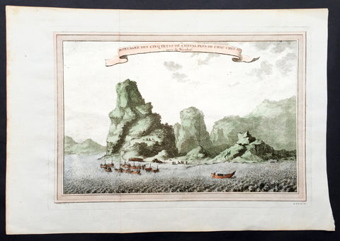
1750 Prevost & Nieuhoff Antique Print View of the Zoushan Archip. Zhejiang China
- Title: Montagne Des Cinq Tetes De Cheval Pres De Chau Cheu Fu
- Date: 1747
- Condition : (A+) Fine Condition
- Ref: 15850
- Size: 14in x 10in (355mm x 255mm)
Description:
This fine original copper-plate engraved antique print a view of the Islands of Zoushan in the in north-eastern Zhejiang Province of eastern China was engraved by Jakob van Schley - after Johannes Nieuhoff - and was published in Antoine François Prevosts 15 volumes of Histoire Generale des Voyageswritten by Prevost & other authors between 1746-1790.
Johannes Nieuhoff (1618-72) was a Dutch diplomat and adventurer, who was perhaps the most widely traveled individual of the seventeenth-century. His experiences included important expeditions to various locations in Brazil, Africa, India, Indonesia, and China. From 1655-57, Nieuhoff made an epic 2,400 trek through China, from Canton to Beijing.
During his Chinese expedition he made numerous drawings of the sites he encountered, including the port town of Chau Cheu Fu in the southern province of Guandong, which was the basis for the present print. Nieuhoff’s important written account, along with engravings of his drawings was first published as Legatio batavica ad magnum Tartariæ chamum Sungteium, modernum Sinæ imperatorem (Amsterdam, 1668). His illustrations proved to be highly influential, as they did much to spawn the genre of chinoiserie in European art and design.
General Definitions:
Paper thickness and quality: - Heavy and stable
Paper color : - off white
Age of map color: - Ewarly
Colors used: - Green, yellow, pink
General color appearance: - Authentic
Paper size: - 14in x 10in (365mm x 250mm)
Plate size: - 12in x 8in (305mm x 205mm)
Margins: - Min 1/2in (12mm)
Imperfections:
Margins: - None
Plate area: - Folds as issued
Verso: - None
Background:
One of Antoine Francois Prevosts monumental undertakings was his history of exploration & discovery in 15 volumes titledHistoire Générale des Voyages written between 1746-1759 and was extended to 20 volumes after his death by various authors.
The 20 volumes cover the early explorations & discoveries on 3 continents: Africa (v. 1-5), Asia (v. 5-11), and America (v. 12-15) with material on the finding of the French, English, Dutch, and Portugese.
A number of notable cartographers and engravers contributed to the copper plate maps and views to the 20 volumes including Nicolas Bellin, Jan Schley, Chedel, Franc Aveline, Fessard, and many others.
The African volumes cover primarily coastal countries of West, Southern, and Eastern Africa, plus the Congo, Madagascar, Arabia and the Persian Gulf areas.
The Asian volumes cover China, Korea, Tibet, Japan, Philippines, and countries bordering the Indian Ocean.
Volume 11 includes Australia and Antarctica.
Volumes 12-15 cover voyages and discoveries in America, including the East Indies, South, Central and North America.
Volumes 16-20 include supplement volumes & tables along with continuation of voyages and discoveries in Russia, Northern Europe, America, Asia & Australia.
Jakob van der Schley aka Jakob van Schley (1715 - 1779) was a Dutch draughtsman and engraver. He studied under Bernard Picart (1673-1733) whose style he subsequently copied. His main interests were engraving portraits and producing illustrations for \"La Vie de Marianne\" by Pierre Carlet de Chamblain de Marivaux (1688-1763) published in The Hague between 1735 and 1747.
He also engraved the frontispieces for a 15-volume edition of the complete works of Pierre de Brantôme (1540-1614), \"Oeuvres du seigneur de Brantôme\", published in The Hague in 1740.
He is also responsible for most of the plates in the Hague edition of Prévost\'s Histoire générale des voyages. (Ref: Tooley; M&B)
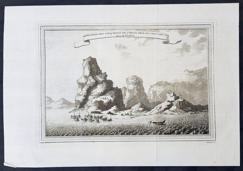
1750 Prevost & Nieuhoff Antique Print View of the Zoushan Archip. Zhejiang China
- Title: Montagne Des Cinq Tetes De Cheval Pres De Chau Cheu Fu
- Date: 1747
- Condition : (A+) Fine Condition
- Ref: 34138
- Size: 14in x 10in (355mm x 255mm)
Description:
This fine original copper-plate engraved antique print a view of the Islands of Zoushan in the in north-eastern Zhejiang Province of eastern China was engraved by Jakob van Schley - after Johannes Nieuhoff - and was published in Antoine François Prevosts 15 volumes of Histoire Generale des Voyageswritten by Prevost & other authors between 1746-1790.
Johannes Nieuhoff (1618-72) was a Dutch diplomat and adventurer, who was perhaps the most widely traveled individual of the seventeenth-century. His experiences included important expeditions to various locations in Brazil, Africa, India, Indonesia, and China. From 1655-57, Nieuhoff made an epic 2,400 trek through China, from Canton to Beijing.
During his Chinese expedition he made numerous drawings of the sites he encountered, including the port town of Chau Cheu Fu in the southern province of Guandong, which was the basis for the present print. Nieuhoff’s important written account, along with engravings of his drawings was first published as Legatio batavica ad magnum Tartariæ chamum Sungteium, modernum Sinæ imperatorem (Amsterdam, 1668). His illustrations proved to be highly influential, as they did much to spawn the genre of chinoiserie in European art and design.
General Definitions:
Paper thickness and quality: - Heavy and stable
Paper color : - off white
Age of map color: -
Colors used: -
General color appearance: -
Paper size: - 14in x 10in (365mm x 250mm)
Plate size: - 12in x 8in (305mm x 205mm)
Margins: - Min 1/2in (12mm)
Imperfections:
Margins: - None
Plate area: - Folds as issued
Verso: - None
Background:
One of Antoine Francois Prevosts monumental undertakings was his history of exploration & discovery in 15 volumes titledHistoire Générale des Voyages written between 1746-1759 and was extended to 20 volumes after his death by various authors.
The 20 volumes cover the early explorations & discoveries on 3 continents: Africa (v. 1-5), Asia (v. 5-11), and America (v. 12-15) with material on the finding of the French, English, Dutch, and Portugese.
A number of notable cartographers and engravers contributed to the copper plate maps and views to the 20 volumes including Nicolas Bellin, Jan Schley, Chedel, Franc Aveline, Fessard, and many others.
The African volumes cover primarily coastal countries of West, Southern, and Eastern Africa, plus the Congo, Madagascar, Arabia and the Persian Gulf areas.
The Asian volumes cover China, Korea, Tibet, Japan, Philippines, and countries bordering the Indian Ocean.
Volume 11 includes Australia and Antarctica.
Volumes 12-15 cover voyages and discoveries in America, including the East Indies, South, Central and North America.
Volumes 16-20 include supplement volumes & tables along with continuation of voyages and discoveries in Russia, Northern Europe, America, Asia & Australia.
Jakob van der Schley aka Jakob van Schley (1715 - 1779) was a Dutch draughtsman and engraver. He studied under Bernard Picart (1673-1733) whose style he subsequently copied. His main interests were engraving portraits and producing illustrations for \"La Vie de Marianne\" by Pierre Carlet de Chamblain de Marivaux (1688-1763) published in The Hague between 1735 and 1747.
He also engraved the frontispieces for a 15-volume edition of the complete works of Pierre de Brantôme (1540-1614), \"Oeuvres du seigneur de Brantôme\", published in The Hague in 1740.
He is also responsible for most of the plates in the Hague edition of Prévost\'s Histoire générale des voyages. (Ref: Tooley; M&B)
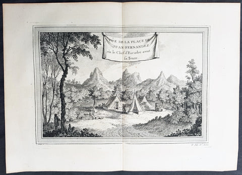
1750 Prevost Antique View of Juan Fernandez Island Chile, Alex. Selkirk & R. Crusoe
- Title: Vue de la Place de Juan Fernandez ou le Chef d Escadre avont sa Tente
- Date: 1750
- Condition : (A+) Fine Condition
- Ref: 25754
- Size: 14in x 10in (355mm x 255mm)
Description:
This fine original copper-plate engraved antique print was engraved by Jakob van Schley and was published in Antoine François Prevosts 15 volumes of Histoire Generale des Voyages written by Prevost & other authors between 1746-1790.
Alexander Selkirk (1676 - 1721) was a Scottish sailor who spent four years as a castaway when he was marooned on an uninhabited island, Juan Fernández Island off the coast of Chile. It is his travels that provided the inspiration for Daniel Defoe\'s novel Robinson Crusoe.
At an early period he was engaged in buccaneer expeditions to the South Seas and in 1703 joined in with the expedition of famed privateer and explorer William Dampier. While Dampier was captain of the St. George, Selkirk served on the galley Cinque Ports, the St. George\'s companion, as a sailing master serving under Thomas Stradling.
In October 1704, after the ships had parted ways because of a dispute between Stradling and Dampier, the Cinque Ports was brought by Stradling to the uninhabited archipelago of Juan Fernández off the coast of Chile for a mid-expedition restocking of supplies and fresh water. Selkirk had grave concerns by this time about the seaworthiness of this vessel (indeed, the Cinque Ports later foundered, losing most of its hands). He tried to convince some of his crewmates to desert with him, remaining on the island; he was counting on an impending visit by another ship. No one else agreed to come along with him. Stradling declared that he would grant him his wish and leave him alone on Juan Fernández. Selkirk promptly regretted his decision. He chased and called after the boat, to no avail. Selkirk lived the next four years and four months without any human company. All he had brought with him was a musket, gunpowder, carpenter\'s tools, a knife, a Bible, some clothing and rope.
His long-anticipated rescue occurred on 1 February 1709 by way of the Duke, a privateering ship piloted by the above-mentioned William Dampier. Selkirk was discovered by the Duke\'s captain, Woodes Rogers, who referred to him as Governor of the island. Now rescued, he was almost incoherent in his joy. The agile Selkirk, catching two or three goats a day, helped restore the health of Rogers\' men. Rogers eventually made Selkirk his mate, giving him independent command of one of his ships. Rogers\' A cruising voyage round the world: first to the South-Sea, thence to the East-Indies, and homewards by the Cape of Good Hope was published in 1712 and included an account of Selkirk\'s ordeal. (Ref: Tooley; M&B)
General Definitions:
Paper thickness and quality: - Heavy and stable
Paper color : - off white
Age of map color: -
Colors used: -
General color appearance: -
Paper size: - 14in x 10in (365mm x 250mm)
Plate size: - 12in x 8in (305mm x 205mm)
Margins: - Min 1/2in (12mm)
Imperfections:
Margins: - None
Plate area: - None
Verso: - None
Background:
One of Antoine Francois Prevosts monumental undertakings was his history of exploration & discovery in 15 volumes titledHistoire Générale des Voyages written between 1746-1759 and was extended to 20 volumes after his death by various authors.
The 20 volumes cover the early explorations & discoveries on 3 continents: Africa (v. 1-5), Asia (v. 5-11), and America (v. 12-15) with material on the finding of the French, English, Dutch, and Portugese.
A number of notable cartographers and engravers contributed to the copper plate maps and views to the 20 volumes including Nicolas Bellin, Jan Schley, Chedel, Franc Aveline, Fessard, and many others.
The African volumes cover primarily coastal countries of West, Southern, and Eastern Africa, plus the Congo, Madagascar, Arabia and the Persian Gulf areas.
The Asian volumes cover China, Korea, Tibet, Japan, Philippines, and countries bordering the Indian Ocean.
Volume 11 includes Australia and Antarctica.
Volumes 12-15 cover voyages and discoveries in America, including the East Indies, South, Central and North America.
Volumes 16-20 include supplement volumes & tables along with continuation of voyages and discoveries in Russia, Northern Europe, America, Asia & Australia.
Jakob van der Schley aka Jakob van Schley (1715 - 1779) was a Dutch draughtsman and engraver. He studied under Bernard Picart (1673-1733) whose style he subsequently copied. His main interests were engraving portraits and producing illustrations for \"La Vie de Marianne\" by Pierre Carlet de Chamblain de Marivaux (1688-1763) published in The Hague between 1735 and 1747.
He also engraved the frontispieces for a 15-volume edition of the complete works of Pierre de Brantôme (1540-1614), \"Oeuvres du seigneur de Brantôme\", published in The Hague in 1740.
He is also responsible for most of the plates in the Hague edition of Prévost\'s Histoire générale des voyages. (Ref: Tooley; M&B)
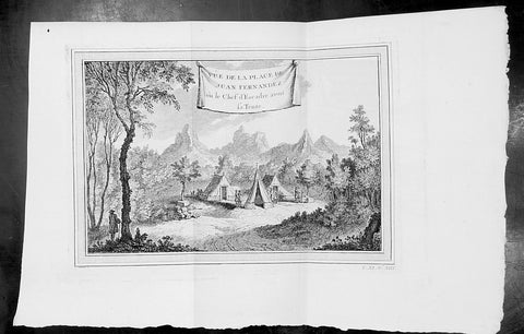
1750 Prevost Antique View of Juan Fernandez Island Chile, Alex. Selkirk & R. Crusoe
- Title: Vue de la Place de Juan Fernandez ou le Chef d Escadre avont sa Tente
- Date: 1750
- Condition : (A+) Fine Condition
- Ref: 34129
- Size: 14in x 10in (355mm x 255mm)
Description:
This fine original copper-plate engraved antique print was engraved by Jakob van Schley and was published in Antoine François Prevosts 15 volumes of Histoire Generale des Voyages written by Prevost & other authors between 1746-1790.
Alexander Selkirk (1676 - 1721) was a Scottish sailor who spent four years as a castaway when he was marooned on an uninhabited island, Juan Fernández Island off the coast of Chile. It is his travels that provided the inspiration for Daniel Defoe\'s novel Robinson Crusoe.
At an early period he was engaged in buccaneer expeditions to the South Seas and in 1703 joined in with the expedition of famed privateer and explorer William Dampier. While Dampier was captain of the St. George, Selkirk served on the galley Cinque Ports, the St. George\'s companion, as a sailing master serving under Thomas Stradling.
In October 1704, after the ships had parted ways because of a dispute between Stradling and Dampier, the Cinque Ports was brought by Stradling to the uninhabited archipelago of Juan Fernández off the coast of Chile for a mid-expedition restocking of supplies and fresh water. Selkirk had grave concerns by this time about the seaworthiness of this vessel (indeed, the Cinque Ports later foundered, losing most of its hands). He tried to convince some of his crewmates to desert with him, remaining on the island; he was counting on an impending visit by another ship. No one else agreed to come along with him. Stradling declared that he would grant him his wish and leave him alone on Juan Fernández. Selkirk promptly regretted his decision. He chased and called after the boat, to no avail. Selkirk lived the next four years and four months without any human company. All he had brought with him was a musket, gunpowder, carpenter\'s tools, a knife, a Bible, some clothing and rope.
His long-anticipated rescue occurred on 1 February 1709 by way of the Duke, a privateering ship piloted by the above-mentioned William Dampier. Selkirk was discovered by the Duke\'s captain, Woodes Rogers, who referred to him as Governor of the island. Now rescued, he was almost incoherent in his joy. The agile Selkirk, catching two or three goats a day, helped restore the health of Rogers\' men. Rogers eventually made Selkirk his mate, giving him independent command of one of his ships. Rogers\' A cruising voyage round the world: first to the South-Sea, thence to the East-Indies, and homewards by the Cape of Good Hope was published in 1712 and included an account of Selkirk\'s ordeal. (Ref: Tooley; M&B)
General Definitions:
Paper thickness and quality: - Heavy and stable
Paper color : - off white
Age of map color: -
Colors used: -
General color appearance: -
Paper size: - 14in x 10in (365mm x 250mm)
Plate size: - 12in x 8in (305mm x 205mm)
Margins: - Min 1/2in (12mm)
Imperfections:
Margins: - None
Plate area: - None
Verso: - None
Background:
One of Antoine Francois Prevosts monumental undertakings was his history of exploration & discovery in 15 volumes titledHistoire Générale des Voyages written between 1746-1759 and was extended to 20 volumes after his death by various authors.
The 20 volumes cover the early explorations & discoveries on 3 continents: Africa (v. 1-5), Asia (v. 5-11), and America (v. 12-15) with material on the finding of the French, English, Dutch, and Portugese.
A number of notable cartographers and engravers contributed to the copper plate maps and views to the 20 volumes including Nicolas Bellin, Jan Schley, Chedel, Franc Aveline, Fessard, and many others.
The African volumes cover primarily coastal countries of West, Southern, and Eastern Africa, plus the Congo, Madagascar, Arabia and the Persian Gulf areas.
The Asian volumes cover China, Korea, Tibet, Japan, Philippines, and countries bordering the Indian Ocean.
Volume 11 includes Australia and Antarctica.
Volumes 12-15 cover voyages and discoveries in America, including the East Indies, South, Central and North America.
Volumes 16-20 include supplement volumes & tables along with continuation of voyages and discoveries in Russia, Northern Europe, America, Asia & Australia.
Jakob van der Schley aka Jakob van Schley (1715 - 1779) was a Dutch draughtsman and engraver. He studied under Bernard Picart (1673-1733) whose style he subsequently copied. His main interests were engraving portraits and producing illustrations for \"La Vie de Marianne\" by Pierre Carlet de Chamblain de Marivaux (1688-1763) published in The Hague between 1735 and 1747.
He also engraved the frontispieces for a 15-volume edition of the complete works of Pierre de Brantôme (1540-1614), \"Oeuvres du seigneur de Brantôme\", published in The Hague in 1740.
He is also responsible for most of the plates in the Hague edition of Prévost\'s Histoire générale des voyages. (Ref: Tooley; M&B)
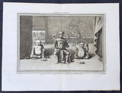
1750 Prevost Original Antique Print of 3 Statues or Deities in a Chinese Pagoda
- Title: Pagodes ou Statue
- Date: 1750
- Condition : (A+) Fine Condition
- Ref: 25951
- Size: 14in x 10in (355mm x 255mm)
Description:
This fine original copper-plate engraved antique print was engraved by Jakob van Schley and was published in Antoine François Prevosts 15 volumes of Histoire Generale des Voyages written by Prevost & other authors between 1746-1790.
Unique original print of Chinese statues in the interior of a Chinese Pagoda. The scale of the statues are illustrated by the worshipers at the feet of each statue. There is a key to each statue at the bottom of the page
No 1. Mini so, ou la Volupte - A corpulent and grinning statues representing the spirit of pleasure
No 2. Le Grand Kin Gang - An elaborately dressed imperial figure on a throne.
No 3. L immortalite - A pot-bellied, crosslegged god accompanied by a deer and a stork, the personification of immortality
In the background is a group of monks gathered next to a podium, upon which is another statue flanked by incense burners.
General Definitions:
Paper thickness and quality: - Heavy and stable
Paper color : - off white
Age of map color: -
Colors used: -
General color appearance: -
Paper size: - 14in x 10in (365mm x 250mm)
Plate size: - 12in x 8in (305mm x 205mm)
Margins: - Min 1/2in (12mm)
Imperfections:
Margins: - None
Plate area: - None
Verso: - None
Background:
One of Antoine Francois Prevosts monumental undertakings was his history of exploration & discovery in 15 volumes titledHistoire Générale des Voyages written between 1746-1759 and was extended to 20 volumes after his death by various authors.
The 20 volumes cover the early explorations & discoveries on 3 continents: Africa (v. 1-5), Asia (v. 5-11), and America (v. 12-15) with material on the finding of the French, English, Dutch, and Portugese.
A number of notable cartographers and engravers contributed to the copper plate maps and views to the 20 volumes including Nicolas Bellin, Jan Schley, Chedel, Franc Aveline, Fessard, and many others.
The African volumes cover primarily coastal countries of West, Southern, and Eastern Africa, plus the Congo, Madagascar, Arabia and the Persian Gulf areas.
The Asian volumes cover China, Korea, Tibet, Japan, Philippines, and countries bordering the Indian Ocean.
Volume 11 includes Australia and Antarctica.
Volumes 12-15 cover voyages and discoveries in America, including the East Indies, South, Central and North America.
Volumes 16-20 include supplement volumes & tables along with continuation of voyages and discoveries in Russia, Northern Europe, America, Asia & Australia.
Jakob van der Schley aka Jakob van Schley (1715 - 1779) was a Dutch draughtsman and engraver. He studied under Bernard Picart (1673-1733) whose style he subsequently copied. His main interests were engraving portraits and producing illustrations for \"La Vie de Marianne\" by Pierre Carlet de Chamblain de Marivaux (1688-1763) published in The Hague between 1735 and 1747.
He also engraved the frontispieces for a 15-volume edition of the complete works of Pierre de Brantôme (1540-1614), \"Oeuvres du seigneur de Brantôme\", published in The Hague in 1740.
He is also responsible for most of the plates in the Hague edition of Prévost\'s Histoire générale des voyages. (Ref: Tooley; M&B)
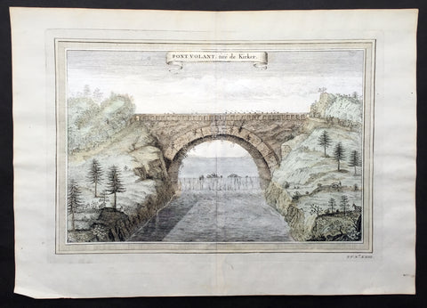
1750 Prevost, after Kircher, Antique Print Bridge over Yellow River, Xensi China
- Title : Pont Volant, tire de Kirker
- Size: 14 1/2in x 9 1/2in (370mm x 240mm)
- Ref #: 25694
- Date : 1750
- Condition: (A+) Fine Condition
Description:
This fine original copper-plate engraved antique print a view of a single Arch Bridge over the Yellow River in Xensi Province near Chogan was engraved by Jakob van Schley -
after Athanasius Kirchers China Illustrated - was published in Antoine François Prevosts 15 volumes of Histoire Generale des Voyageswritten by Prevost & other authors between 1746-1790.
Athanasius Kircher, S.J. sometimes erroneously spelled Kirchner; Latin: Athanasius Kircherus, 1602 – 1680 was a German Jesuit scholar and polymath who published around 40 major works, most notably in the fields of comparative religion, geology, and medicine. Kircher has been compared to fellow Jesuit Roger Boscovich and to Leonardo da Vinci for his enormous range of interests, and has been honored with the title \"Master of a Hundred Arts\". He taught for more than forty years at the Roman College, where he set up a wunderkammer. A resurgence of interest in Kircher has occurred within the scholarly community in recent decades.
Kircher claimed to have deciphered the hieroglyphic writing of the ancient Egyptian language, but most of his assumptions and translations in this field were later found to be nonsensical. He did, however, correctly establish the link between the ancient Egyptian and the Coptic languages, and some commentators regard him as the founder of Egyptology. Kircher was also fascinated with Sinology and wrote an encyclopedia of China, in which he noted the early presence there of Nestorian Christians while also attempting to establish links with Egypt and Christianity.
Kircher had an early interest in China, telling his superior in 1629 that he wished to become a missionary to that country. In 1667 he published a treatise whose full title was China monumentis, qua sacris qua profanis, nec non variis naturae & artis spectaculis, aliarumque rerum memorabilium argumentis illustrata, and which is commonly known simply as China Illustrata, i.e. \"China Illustrated\". It was a work of encyclopedic breadth, combining material of unequal quality, from accurate cartography to mythical elements, such as a study of dragons. The work drew heavily on the reports of Jesuits working in China, in particular Michael Boymand Martino Martini.
China Illustrata emphasized the Christian elements of Chinese history, both real and imagined: the book noted the early presence of Nestorian Christians (with a Latin translation of the Nestorian Stele of Xi\'an provided by Boym and his Chinese collaborator, Andrew Zheng) but also claimed that the Chinese were descended from the sons of Ham, that Confucius was Hermes Trismegistus/Moses and that the Chinese characters were abstracted hieroglyphs.
In Kircher\'s system, ideograms were inferior to hieroglyphs because they referred to specific ideas rather than to mysterious complexes of ideas, while the signs of the Maya and Aztecs were yet lower pictograms which referred only to objects. Umberto Eco comments that this idea reflected and supported the ethnocentric European attitude toward Chinese and native American civilizations;
\"China was presented not as an unknown barbarian to be defeated but as a prodigal son who should return to the home of the common father\"
General Definitions:
Paper thickness and quality: - Heavy and stable
Paper color : - off white
Age of map color: - Early
Colors used: - Yellow, green, pink
General color appearance: - Authentic
Paper size: - 14 1/2in x 9 1/2in (370mm x 240mm)
Plate size: - 12in x 8in (305mm x 205mm)
Margins: - Min 1/2in (12mm)
Imperfections:
Margins: - None
Plate area: - None
Verso: - None
Background:
One of Antoine Francois Prevosts monumental undertakings was his history of exploration & discovery in 15 volumes titledHistoire Générale des Voyages written between 1746-1759 and was extended to 20 volumes after his death by various authors.
The 20 volumes cover the early explorations & discoveries on 3 continents: Africa (v. 1-5), Asia (v. 5-11), and America (v. 12-15) with material on the finding of the French, English, Dutch, and Portugese.
A number of notable cartographers and engravers contributed to the copper plate maps and views to the 20 volumes including Nicolas Bellin, Jan Schley, Chedel, Franc Aveline, Fessard, and many others.
The African volumes cover primarily coastal countries of West, Southern, and Eastern Africa, plus the Congo, Madagascar, Arabia and the Persian Gulf areas.
The Asian volumes cover China, Korea, Tibet, Japan, Philippines, and countries bordering the Indian Ocean.
Volume 11 includes Australia and Antarctica.
Volumes 12-15 cover voyages and discoveries in America, including the East Indies, South, Central and North America.
Volumes 16-20 include supplement volumes & tables along with continuation of voyages and discoveries in Russia, Northern Europe, America, Asia & Australia.
Jakob van der Schley aka Jakob van Schley (1715 - 1779) was a Dutch draughtsman and engraver. He studied under Bernard Picart (1673-1733) whose style he subsequently copied. His main interests were engraving portraits and producing illustrations for \"La Vie de Marianne\" by Pierre Carlet de Chamblain de Marivaux (1688-1763) published in The Hague between 1735 and 1747.
He also engraved the frontispieces for a 15-volume edition of the complete works of Pierre de Brantôme (1540-1614), \"Oeuvres du seigneur de Brantôme\", published in The Hague in 1740.
He is also responsible for most of the plates in the Hague edition of Prévost\'s Histoire générale des voyages. (Ref: Tooley; M&B)
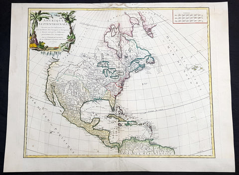
1750 Robert De Vaugondy Large Antique Map of Colonial North America, 1st Edition
Antique Map
- Title : Amérique Septentrionale, dressée, sur les Relations les plus modernes des Voyageurs et Navigateurs, et divisée suivant les differentes possessions des Européens...Par Le Sr Robert De Vaugondy 1750 [North America, drawn from the most recent accounts of the Voyagers and Navigators, and divided according to the different possessions of the Europeans...Robert De Vaugondy 1750
- Date : 1750
- Condition: (A+) Fine Condition
- Ref: 93358
- Size: 27 1/2in x 21in (700mm x 535mm)
Description:
This large beautifully hand coloured original 1st edition antique map of North America by Robert De Vaugondy in 1750 - dated in cartouche - was published in the 1757 edition of Atlas Universel, one of the most important atlases of the 18th century.
A beautifully executed & iconic mid 18th century antique map of the entire continent of North America, from Arctic Canada to Central America.
This map is a must for any American map collection. Beautiful original hand colour, a heavy impression (denoting an early pressing) on heavy sturdy paper with original margins, an exciting map .
General Definitions:
Paper thickness and quality: - Heavy and stable
Paper color : - off white
Age of map color: - Original
Colors used: - Yellow, green, blue, pink
General color appearance: - Authentic
Paper size: - 27 1/2in x 21in (700mm x 535mm)
Plate size: - 25in x 19 1/2in (635mm x 495mm)
Margins: - Min 1in (25mm)
Imperfections:
Margins: - Soiling in top margin
Plate area: - None
Verso: - Light age toning
Background:
This attractive map depicts a fascinating period time in the history of North America, immediately before the French and Indian War. The British Thirteen Colonies hug the Atlantic seaboard, while the immense Gallic empire, embracing both New France (Canada) and Louisiana (the Mississippi Basin) occupy the majority of the interior of the continent. This highly detailed map labels numerous native villages and European forts in the interior of the continent. Spanish Mexico reaches all the way north to modern-day Colorado, and Baja California is shown accurately to be a peninsula, and not an island as previously thought. The Pacific Northwest remains entirely enigmatic, labelled as the Terres Inconnues. The map also depicts the islands of the Caribbean, which are shown to be in the possession of the various European powers. Vaugondy consulted several sources in devising his map including Bellins excellent rendering of the Great Lakes, and Guillame De L Isles and Jean-Baptiste D\'Anvilles maps of the Mississippi Basin. The composition is graced by an elegant title cartouche featuring a waterfall inhabited by a cayman, and framed by coulisses of palm trees accompanied by native Americans.
1751 D Anville Very Large Antique Map The West Coast of Africa, Gambia & Senegal
Antique Map
- Title : Carte Particuliere De La Cote Occidentale De L'Afrique Depusi le Cap Blanc jusqu'au Cap De Verga et du Cours Des Rivieres De Senega et de Gambie . .MDCCLI
- Ref #: 92324
- Size: 42in x 33in (1.07m x 840mm)
- Date : 1751
- Condition: (A) Very Good Condition
Description:
This very large finely engraved, highly detailed original antique map of of the west coast of Africa covering Gambia and Senegal was engraved in 1751 - dated in the tile cartouche - and was published in Jean-Baptiste Bourguinon D'Anville's large elephant folio atlas Atlas Generale.
Description: D' Anville's maps have a clarity and a directness that is very 'modern'. He incorporated as much known information into his maps as he could. Map extent is from Cap Blanc in the north to Cap de Verga in the south.
Being part of the Mediterranean world, the northern coasts of the African continent as far as the Straits of Gibraltar and even round to the area of the Fortunate Isles (the Canaries) were reasonably well known and quite accurately mapped from ancient times. In particular, Egypt and the Nile Valley were well defined and the Nile itself was, of course, one of the rivers separating the continents in medieval T-O maps. Through Arab traders the shape of the east coast, down the Red Sea as far as the equator, was also known but detail shown in the interior faded into deserts with occasional mountain ranges and mythical rivers. The southern part of the continent, in the Ptolemaic tradition, was assumed to curve to the east to form a land-locked Indian Ocean. The voyages of the Portuguese, organized by Henry the Navigator in the fifteenth century, completely changed the picture and by the end of the century Vasco da Gama had rounded the Cape enabling cartographers to draw a quite presentable coastal outline of the whole continent, even if the interior was to remain largely unknown for the next two or three centuries.
The first separately printed map of Africa (as with the other known continents) appeared in Munster's Geographia from 1540 onwards and the first atlas devoted to Africa only was published in 1588 in Venice by Livio Sanuto, but the finest individual map of the century was that engraved on 8 sheets by Gastaldi, published in Venice in 1564. Apart from maps in sixteenth-century atlases generally there were also magnificent marine maps of 1596 by Jan van Linschoten (engraved by van Langrens) of the southern half of the continent with highly imaginative and decorative detail in the interior. In the next century there were many attractive maps including those of Mercator/Hondius (1606), Speed (1627), Blaeu (1 630), Visscher (1636), de Wit (c. 1670), all embellished with vignettes of harbours and principal towns and bordered with elaborate and colourful figures of their inhabitants, but the interior remained uncharted with the exception of that part of the continent known as Ethiopia, the name which was applied to a wide area including present-day Abyssinia. Here the legends of Prester John lingered on and, as so often happened in other remote parts of the world, the only certain knowledge of the region was provided by Jesuit missionaries. Among these was Father Geronimo Lobo (1595-1678), whose work A Voyage to Abyssinia was used as the basis for a remarkably accurate map published by a German scholar, Hiob Ludolf in 1683. Despite the formidable problems which faced them, the French cartographers G. Delisle (c. 1700-22), J. B. B. d'Anville (1727-49) and N. Bellin (1754) greatly improved the standards of mapping of the continent, improvements which were usually, although not always, maintained by Homann, Seutter, de Ia Rochette, Bowen, Faden and many others in the later years of the century. (Ref: Tooley, M&B)
General Description:
Paper thickness and quality: - Heavy and stable
Paper color: - White
Age of map color: -
Colors used: -
General color appearance: -
Paper size: - 42in x 33in (1.07m x 840mm)
Plate size: - 40 1/2in x 28in (1.02m x 710mm)
Margins: - Min 1in (25mm)
Imperfections:
Margins: - Light soiling
Plate area: - Light soiling
Verso: - Light soiling

1751 D Anville Very Large Antique Map The West Coast of Africa, Slave Coast
Antique Map
- Title : Carte Particuliere De La Cote Occidentale De L'Afrique Depusi le Cap Blanc jusqu'au Cap De Verga et du Cours Des Rivieres De Senega et de Gambie . .MDCCLI
- Ref #: 22009
- Size: 42in x 33in (1.07m x 840mm)
- Date : 1751
- Condition: (A+) Fine Condition
Description:
This very large finely engraved, highly detailed original antique map of of the west coast of Africa covering Gambia and Senegal was engraved in 1751 - dated in the tile cartouche - and was published in Jean-Baptiste Bourguinon D'Anville's large elephant folio atlas Atlas Generale.
Description: D' Anville's maps have a clarity and a directness that is very 'modern'. He incorporated as much known information into his maps as he could. Map extent is from Cap Blanc in the north to Cap de Verga in the south.
Being part of the Mediterranean world, the northern coasts of the African continent as far as the Straits of Gibraltar and even round to the area of the Fortunate Isles (the Canaries) were reasonably well known and quite accurately mapped from ancient times. In particular, Egypt and the Nile Valley were well defined and the Nile itself was, of course, one of the rivers separating the continents in medieval T-O maps. Through Arab traders the shape of the east coast, down the Red Sea as far as the equator, was also known but detail shown in the interior faded into deserts with occasional mountain ranges and mythical rivers. The southern part of the continent, in the Ptolemaic tradition, was assumed to curve to the east to form a land-locked Indian Ocean. The voyages of the Portuguese, organized by Henry the Navigator in the fifteenth century, completely changed the picture and by the end of the century Vasco da Gama had rounded the Cape enabling cartographers to draw a quite presentable coastal outline of the whole continent, even if the interior was to remain largely unknown for the next two or three centuries.
The first separately printed map of Africa (as with the other known continents) appeared in Munster's Geographia from 1540 onwards and the first atlas devoted to Africa only was published in 1588 in Venice by Livio Sanuto, but the finest individual map of the century was that engraved on 8 sheets by Gastaldi, published in Venice in 1564. Apart from maps in sixteenth-century atlases generally there were also magnificent marine maps of 1596 by Jan van Linschoten (engraved by van Langrens) of the southern half of the continent with highly imaginative and decorative detail in the interior. In the next century there were many attractive maps including those of Mercator/Hondius (1606), Speed (1627), Blaeu (1 630), Visscher (1636), de Wit (c. 1670), all embellished with vignettes of harbours and principal towns and bordered with elaborate and colourful figures of their inhabitants, but the interior remained uncharted with the exception of that part of the continent known as Ethiopia, the name which was applied to a wide area including present-day Abyssinia. Here the legends of Prester John lingered on and, as so often happened in other remote parts of the world, the only certain knowledge of the region was provided by Jesuit missionaries. Among these was Father Geronimo Lobo (1595-1678), whose work A Voyage to Abyssinia was used as the basis for a remarkably accurate map published by a German scholar, Hiob Ludolf in 1683. Despite the formidable problems which faced them, the French cartographers G. Delisle (c. 1700-22), J. B. B. d'Anville (1727-49) and N. Bellin (1754) greatly improved the standards of mapping of the continent, improvements which were usually, although not always, maintained by Homann, Seutter, de Ia Rochette, Bowen, Faden and many others in the later years of the century. (Ref: Tooley, M&B)
General Description:
Paper thickness and quality: - Heavy and stable
Paper color: - White
Age of map color: -
Colors used: -
General color appearance: -
Paper size: - 42in x 33in (1.07m x 840mm)
Plate size: - 40 1/2in x 28in (1.02m x 710mm)
Margins: - Min 1in (25mm)
Imperfections:
Margins: - None
Plate area: - Light text offsetting
Verso: - None
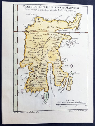
1752 Bellin Antique Map of the Island of Sulawesi, formerly Celebes, Indonesia
- Title: Carte De L'Isle Celebes ou Macassar...S Bellin
- Date: 1752
- Condition : (A+) Fine Condition
- Ref: 60919
- Size: 10in x 7 1/2in (255m x 190mm)
Description:
This fine, original copper-plate engraved antique map of the Indonesian Island of Sulawesi, formerly known as Celebes, by Jacques Nicolas Bellin in 1752 was published in Antoine François Prevosts 15 volumes of Histoire Generale des Voyages written by Prevost & other authors between 1746-1790.
Sulawesi, formerly known as Celebes, is one of the four Greater Sunda Islands, and the world\'s eleventh-largest island, it is situated east of Borneo, west of the Maluku Islands, and south of Mindanao and the Sulu Archipelago. Within Indonesia, only Sumatra, Borneo and Papua are larger in territory, and only Java and Sumatra have larger populations.
Starting in the 13th century, access to prestige trade goods and to sources of iron started to alter long-standing cultural patterns and to permit ambitious individuals to build larger political units. It is not known why these two ingredients appeared together; one was perhaps the product of the other.
In 1367, several identified polities, located on the island, were mentioned in the Javanese manuscript Nagarakretagama dated from the Majapahit period. Canto 14 mentioned polities including Gowa, Makassar, Luwu and Banggai. It seems that by the 14th century, polities in the island were connected in an archipelagic maritime trading network, centered in the Majapahit port in East Java. By 1400, a number of nascent agricultural principalities had arisen in the western Cenrana valley, as well as on the south coast and on the west coast near modern Parepare.
The first Europeans to visit the island (which they believed to be an archipelago due to its contorted shape) were the Portuguese sailors Simão de Abreu, in 1523, and Gomes de Sequeira (among others) in 1525, sent from the Moluccas in search of gold, which the islands had the reputation of producing. A Portuguese base was installed in Makassar in the first decades of the 16th century, lasting until 1665, when it was taken by the Dutch. The Dutch had arrived in Sulawesi in 1605 and were quickly followed by the English, who established a factory in Makassar. From 1660, the Dutch were at war with Gowa, the major Makasar west coast power. In 1669, Admiral Speelman forced the ruler, Sultan Hasanuddin, to sign the Treaty of Bongaya, which handed control of trade to the Dutch East India Company. The Dutch were aided in their conquest by the Bugis warlord Arung Palakka, ruler of the Bugis kingdom of Bone. The Dutch built a fort at Ujung Pandang, while Arung Palakka became the regional overlord and Bone the dominant kingdom. Political and cultural development seems to have slowed as a result of the status quo.
General Definitions:
Paper thickness and quality: - Heavy and stable
Paper color : - off white
Age of map color: - Early
Colors used: - Green, Yellow,
General color appearance: - Authentic
Paper size: - 10in x 7 1/2in (255m x 190mm)
Plate size: - 9in x 6 1/2in (230mm x 160mm)
Margins: - Min 1/2in (6mm)
Imperfections:
Margins: - None
Plate area: - None
Verso: - None
Background:
One of Antoine Francois Prevosts monumental undertakings was his history of exploration & discovery in 15 volumes titledHistoire Générale des Voyages written between 1746-1759 and was extended to 20 volumes after his death by various authors.
The 20 volumes cover the early explorations & discoveries on 3 continents: Africa (v. 1-5), Asia (v. 5-11), and America (v. 12-15) with material on the finding of the French, English, Dutch, and Portugese.
A number of notable cartographers and engravers contributed to the copper plate maps and views to the 20 volumes including Nicolas Bellin, Jan Schley, Chedel, Franc Aveline, Fessard, and many others.
The African volumes cover primarily coastal countries of West, Southern, and Eastern Africa, plus the Congo, Madagascar, Arabia and the Persian Gulf areas.
The Asian volumes cover China, Korea, Tibet, Japan, Philippines, and countries bordering the Indian Ocean.
Volume 11 includes Australia and Antarctica.
Volumes 12-15 cover voyages and discoveries in America, including the East Indies, South, Central and North America.
Volumes 16-20 include supplement volumes & tables along with continuation of voyages and discoveries in Russia, Northern Europe, America, Asia & Australia.
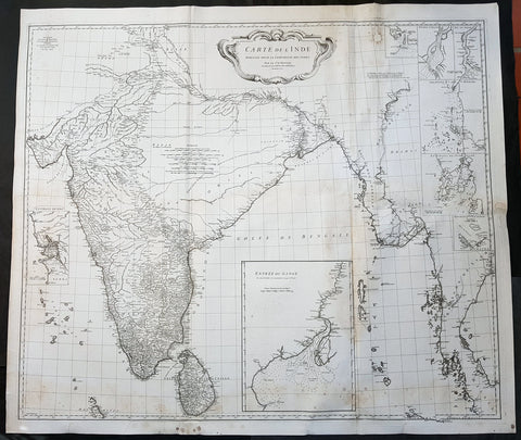
1752 D Anville Large Original Antique Map of India Sri Lanka Burma Siam - Scarce
Antique Map
- Title : Carte De L Inde Dressee Pour La Compagnie Des Indes...1752
- Size: 43in x 37 1/2in (1.1m x 950mm)
- Ref #: 92320
- Date : 1752
- Condition: (A) Very Good Condition
Description:
This large finely engraved scarce and highly detailed original antique map of India, Sri Lanka Burma & Thailand was engraved by Guillaume de la Haye in 1752 - dated in the tile cartouche - and was published in Jean-Baptiste Bourguinon D\'Anville\'s large elephant folio atlas Atlas Generale.
General Definitions:
Paper thickness and quality: - Heavy and stable
Paper color : - off white
Age of map color: -
Colors used: -
General color appearance: -
Paper size: - 43in x 37 1/2in (1.1m x 950mm)
Plate size: - 41in x 35in (1.04m x 890mm)
Margins: - Min 1in (25mm)
Imperfections:
Margins: - Spotting
Plate area: - Spotting, aging toning along folds as issued
Verso: - Spotting, aging toning along folds as issued
Background:
The map is drawn from numerous sources, including Ptolemy, Turkish and Indian geographies, and Jesuit surveys. More contemporary works by Bouchet in 1719 and Boudier in 1734 are seen both in the detail and inset river maps. The map reflects the level of knowledge of India & SE Asia at the time, especially of the interiors. The map has excellent detail of Southern India and coastlines were trade had been happening for centuries, but a conspicuous absence of detail of the northern interior
There are seven Inset maps that include the environs of Goa, entrance of the Ganges River and a wonderfully detailed depiction of the entrance to the Hugli River and other river tributes.
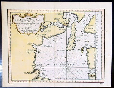
1753 Bellin & Henry Ellis Antique Map of Hudsons Bay, Search for the NW Passage
- Title : Carte Des parties Du Nord-Ouest De L Amerique..Par M.B....1753
- Ref #: 91259
- Size: 12 1/2in x 10in (320m x 255mm)
- Date : 1753
- Condition: (A+) Fine Condition
Description:
This fine, original copper-plate engraved antique map of Hudsons Bay, Canada and Henry Ellis voyage to discover the North West passage by Jacques Nicolas Bellin in 1755 was published in Antoine François Prevosts 15 volumes of Histoire Generale des Voyageswritten by Prevost & other authors between 1746-1790.
Henry Ellis 1721 – 1806 was an explorer, author, and a colonial governor of U.S. state of Georgia and Nova Scotia.
Ellis was born in County Monaghan, Ireland. He was educated in law at the Temple Church in London. In May 1746, he went out as agent of a company for the discovery of the Northwest Passage. After extinguishing with difficulty a fire in his ship, he sailed to Greenland, where he exchanged commodities with the Inuit peoples on 8 July. He then proceeded to Fort Nelson, and wintered in Hayes River. He renewed his efforts in June 1747, without success, and returned to England; where he arrived on 14 October. He published an accounts of his explorations in 1748, entitled \"Voyage made to Hudson\'s Bay in 1746, by the Dobbs Galley and The California, to discover a Northwest Passage\" and in 1750 published \"Considerations on the Great Advantages which would Arise from the Discovery of the North West Passage\". After publishing these accounts, Ellis was inducted into the Royal Society.
From 1750 to 1755, Ellis worked as a slave trader, purchasing slaves from Africa and shipping them to Jamaica.
Lord Halifax, President of the Board of Trade named Ellis lieutenant governor of Georgia, 15 August 1756. Ellis arrived at Savannah, Georgia on 16 February 1757, and on 17 May 1758, was made royal governor. His administration of the colony was highly esteemed. Recognizing the danger posed to the colony by hostile neighbors, he established a treaty with the Creeks. He published \"Heat of the Weather in Georgia\" in Philosophical trans of the Royal Society in 1758. The subtropical climate took its toll on his health, and he had to be removed from governor then left Georgia on 2 November 1760, and stopping in New York to request military assistance to the southern colonies.
After his return to England his knowledge of American affairs were called into requisition for developing the plan for taxing the colonies, and in return for this service he was rewarded with sinecure offices. From 1761 to 1763 he held the commission of governor of Nova Scotia, though he did not enter on the duties of his office. He afterward resided in Italy, principally occupied in scientific researches.Before he died he had a friendship with the creek leader.
He died on January 21, 1806 (aged 84–85) in Naples, Italy.
General Definitions:
Paper thickness and quality: - Heavy and stable
Paper color : - off white
Age of map color: - Early
Colors used: - Yellow, green, red
General color appearance: - Authentic
Paper size: - 12 1/2in x 10in (320m x 255mm)
Plate size: - 11in x 8in (280mm x 205mm)
Margins: - Min 1/2in (12mm)
Imperfections:
Margins: - None
Plate area: - Folds as issued
Verso: - None
Background:
One of Antoine Francois Prevosts monumental undertakings was his history of exploration & discovery in 15 volumes titledHistoire Générale des Voyages written between 1746-1759 and was extended to 20 volumes after his death by various authors.
The 20 volumes cover the early explorations & discoveries on 3 continents: Africa (v. 1-5), Asia (v. 5-11), and America (v. 12-15) with material on the finding of the French, English, Dutch, and Portugese.
A number of notable cartographers and engravers contributed to the copper plate maps and views to the 20 volumes including Nicolas Bellin, Jan Schley, Chedel, Franc Aveline, Fessard, and many others.
The African volumes cover primarily coastal countries of West, Southern, and Eastern Africa, plus the Congo, Madagascar, Arabia and the Persian Gulf areas.
The Asian volumes cover China, Korea, Tibet, Japan, Philippines, and countries bordering the Indian Ocean.
Volume 11 includes Australia and Antarctica.
Volumes 12-15 cover voyages and discoveries in America, including the East Indies, South, Central and North America.
Volumes 16-20 include supplement volumes & tables along with continuation of voyages and discoveries in Russia, Northern Europe, America, Asia & Australia.

1753 Bellin Antique Map of Australia & New Zealand - Carte Reduite.....Australes
Antique Map
- Title : Carte Reduite des Terres Australes pour Servir a l'Histoire des Voyages...1753
- Ref #: 17027
- Size: 13 1/2in x 10in (340mm x 255mm)
- Date : 1753
- Condition: (A+) Fine Condition
Description:
This original copper plate engraved antique map of Australia - one of the earliest, near complete maps, dedicated to the Island Continent - was engraved in 1753 by Jacques Nicolas Bellin - date engraved in the title -and was published in Antoine Prevosts Histoire Generale Des Voyages.
Background: This is one of the few 18th century maps to focus on the Australian continent prior to Cook's famous first voyage from 1768-1771. Mainland Australia is connected to both Tasmania (Terre de Van Diemen) and Papua New Guinea (Nouv. Guinee). Along the imaginary eastern coastline is a note that reads: "I suppose that the land of Diemen can join with the land of the Holy Ghost, but this is without proof." A partial coastline of New Zealand is shown peeking out of the corner of the map, with a note that it was discovered by Abel Tasman in 1642 and speculation that it might be part of a great southern continent. This is an important map of Australia depicting the interesting theories made prior to exploration of the region later in the 18th century. (Ref: Tooley; M&B)
General Description:
Paper thickness and quality: - Heavy and stable
Paper color: - off white
Age of map color: -
Colors used: -
General color appearance: -
Paper size: - 13 1/2in x 10in (340mm x 255mm)
Plate size: - 11 1/2in x 8 1/2in (295mm x 215mm)
Margins: - Min 1in (25mm)
Imperfections:
Margins: - None
Plate area: - Folds as issued
Verso: - None

1753 Bellin Antique Map of Australia & New Zealand - Carte Reduite.....Australes
Antique Map
- Title : Carte Reduite des Terres Australes pour Servir a l'Histoire des Voyages...1753
- Ref #: 17040
- Size: 15in x 10in (380mm x 255mm)
- Date : 1753
- Condition: (A+) Fine Condition
Description:
This original beautifully hand coloured copper plate engraved antique map of Australia - one of the earliest, near complete maps, dedicated to the Island Continent - was engraved in 1753 by Jacques Nicolas Bellin - date engraved in the title -and was published in the 1753 edition of Prevosts Histoire Generale Des Voyages.
Background: This is one of the few 18th century maps to focus on the Australian continent prior to Cook's famous first voyage from 1768-1771. Mainland Australia is connected to both Tasmania (Terre de Van Diemen) and Papua New Guinea (Nouv. Guinee). Along the imaginary eastern coastline is a note that reads: "I suppose that the land of Diemen can join with the land of the Holy Ghost, but this is without proof." A partial coastline of New Zealand is shown peeking out of the corner of the map, with a note that it was discovered by Abel Tasman in 1642 and speculation that it might be part of a great southern continent. This is an important map of Australia depicting the interesting theories made prior to exploration of the region later in the 18th century. (Ref: Tooley; M&B)
General Description:
Paper thickness and quality: - Heavy and stable
Paper color: - off white
Age of map color: - Early
Colors used: - Yellow, green, red, brown.
General color appearance: - Authentic and fresh
Paper size: - 15in x 10in (380mm x 255mm)
Plate size: - 11 1/2in x 8 1/2in (295mm x 215mm)
Margins: - Min 1in (25mm)
Imperfections:
Margins: - None
Plate area: - Folds as issued
Verso: - None
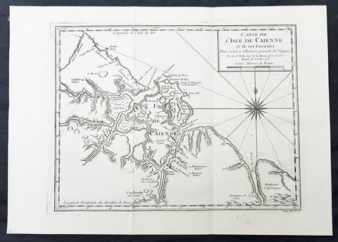
1753 Bellin Antique Map of The Island of Cayenne French Guyana, South America
- Title: Carte de L Isle De Caienne et de ses Environs...1753
- Date: 1753
- Condition : (A+) Fine Condition
- Ref: 92015
- Size: 15in x 11in (390mm x 275mm)
Description:
This fine, original copper-plate engraved antique map of the City Island of Cayenne in French Guyana, South America by Jacques Nicolas Bellin was engraved in 1753 - dated - and was published in Antoine François Prevosts 15 volumes of Histoire Generale des Voyages written by Prevost & other authors between 1746-1790.
Cayenne is the capital city of French Guiana, an overseas region and department of France located in South America. The city stands on a former island at the mouth of the Cayenne River on the Atlantic coast. The city\'s motto is fert aurum industria, which means \"work brings wealth.
Ignored by Spanish explorers, who found the region too hot and poor to be claimed, the region was not colonized until 1604, when a French settlement was founded. However, it was soon destroyed by the Portuguese, who were determined to enforce the provisions of the Treaty of Tordesillas. French colonists returned in 1643 and founded Cayenne, but they were forced to leave once more following Amerindian attacks. In 1664, France finally succeeded at establishing a permanent settlement at Cayenne. Over the next decade the colony changed hands between the French, Dutch, and English, before being restored to France. It was captured by an Anglo-Portuguese force at the invasion of Cayenne in 1809 and administered from Brazil until 1814, when it was returned to French control. It was used as a French penal colony from 1854 to 1938.
General Definitions:
Paper thickness and quality: - Heavy and stable
Paper color : - off white
Age of map color: -
Colors used: -
General color appearance: -
Paper size: - 13in x 10in (330mm x 255mm)
Plate size: - 12in x 9in (305mm x 230mm)
Margins: - Min 1/2in (12mm)
Imperfections:
Margins: - None
Plate area: - None
Verso: - None
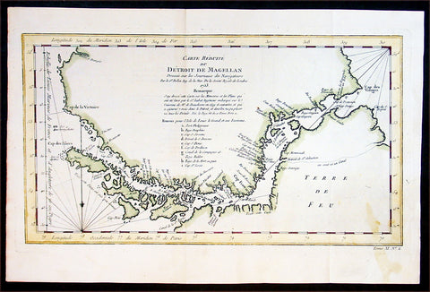
1753 Bellin Antique Map of the Magellan Straits, South America
- Title : Carte Reduite du Detroit De Magellan...1753
- Ref #: 91218
- Size: 15in x 10in (380mm x 255mm)
- Date : 1753
- Condition: (A+) Fine Condition
Description:
This fine hand coloured original antique map of the Magellan Straits between the South American mainland and Tierra Del Fuego - with major points discovered and remarked in a 9 point legend - was engraved by Jacques Nicolas Bellin in 1753 - the date is engraved in the title cartouche - and was published in Antoine-François Prevost's monumental 20 volume edition of L`Histoire Generale des Voyages published by Pierre de Hondt, The Hague between 1747 & 1780. (Ref: Tooley; M&B)
General Description:
Paper thickness and quality: - Heavy and stable
Paper color: - off white
Age of map color: - Later
Colors used: - Yellow, green, red
General color appearance: - Authentic
Paper size: - 15in x 10in (380mm x 255mm)
Plate size: - 14in x 8in (355mm x 205mm)
Margins: - Min 1/2in (12mm)
Imperfections:
Margins: - Light stain bottom right corner
Plate area: - None
Verso: - None
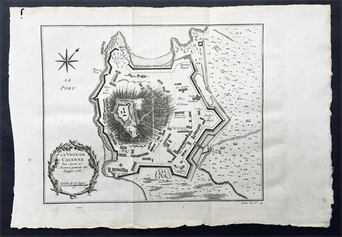
1753 Bellin Antique Map Plan of the City of Cayenne French Guyana, South America
- Title: La Ville De Cayenne...1753
- Date: 1753
- Condition : (A+) Fine Condition
- Ref: 92016
- Size: 15in x 11in (390mm x 275mm)
Description:
This beautifully engraved original antique map a plan of the city of Cayenne capital of French Guyana, South America was engraved by Jacques Nicolas Bellin in 1753 - the date is engraved in the title cartouche - and was published by Jacques Nicolas Bellin for Antoine-François Prevosts 20 volume edition of L`Histoire Generale des Voyages published by Pierre de Hondt, The Hague in 1747. (Ref: Tooley; M&B)
General Description:
Paper thickness and quality: - Heavy and stable
Paper color: - white
Age of map color: -
Colors used: -
General color appearance: -
Paper size: - 15in x 11in (390mm x 275mm)
Plate size: - 11 1/2in x 9 1/2in (290mm x 245mm)
Margins: - min. 1in (25mm)
Imperfections:
Margins: - None
Plate area: - Folds as issued
Verso: - None
Condition : (A+) Fine Condition