Products
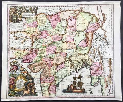
1740 Seutter Large Antique Map of India, Mughal Empire, Tibet, Nepal
- Title : Imperii Magni Mogolis sive Indici Padschach, juxta recentiissimas Navigationes accurata delineato Geographica studio et sumtibus.
- Date : 1740
- Condition: (A+) Fine Condition
- Ref: 42008
- Size: 25in x 20 1/2in (630mm x 520mm)
Description:
This large beautifully hand coloured original antique map of India and the Northern Mughal Empire was published by Georg Mattraus Seutter in 1740.
Background:
Representing 18th century Germany cartography at it’s finest; this is an absolutely spectacular c. 1740 map of northern India by Matthias Seutter. Showing the extent of the powerful Mughal Empire in the late 17th century, this map details the subcontinent and parts of Central Asia from Persia and Khandhar eastward as far a modern day Burma and Thailand. Extends northward to include parts of Tibet and Nepal and southwards as far as the Malabar Coast and the Gulf of Thailand. Cartographically this map is heavily based upon Hondius and Mercator’s 17th century of the same region entitled India Orientalis. Presented is wonderful combination of surprising accuracy, gross errors, and outright speculation. Generally speaking, this map is cartographically solid detailing numerous cities, river systems and trade routes. Shows Deli, Agra, Kandahar (Candahar), Lahore (Lahor), Pegu, Goa, Kabul (Cabul), Jaisalmer (Gislemere), and many other important and still thriving cities. Also notes several important trade routes including the ancient caravan trail westward from Agra into Persia. Despite this map’s thoroughness, there are a number of cartographic errors, probably the most notable of which is the narrowing of the subcontinent. Usually such lateral misrepresentations are the result of erroneous 16th century longitudinal calculations. In this case, these errors found their way into the Hondius’s map and hence into this one as well. The northernmost regions depicted on this map are highly speculative with regard to physical geography. A number of large lakes, including the apocryphal Lake of Chiamay, are speculated in the northeastern quadrants of the map as the sources of four important Southeast Asian river systems including the Irrawaddy, the Dharla, the Chao Phraya, and the Brahmaputra. The curious Lake of Chiamay (also called Chiam-may or Chian-may), roughly located in the area of Assam but sometimes as far north as Tibet and China, began to appear in maps of this region as early as the 16th century and persisted well into the mid 18th century. Its origins are unknown but may originate in a lost 16th century geography prepared by the Portuguese scholar Jao de Barros. It was speculated to be the source of five important Southeast Asian River systems and was mentioned in the journals of Sven Hedin. There are even records that the King of Siam led an invasionary force to take control of the lake in the 16th century. Nonetheless, the theory of Lake Chimmay was ultimately disproved and it disappeared from maps entirely by the 1760s. Decorated with several extremely attractive allegorical cartouche image. The title cartouche in the lower left hand quadrant shows Poseidon, Hermes, an angel and the goddess Fame admiring the wealth of Asia as represented by jewels, ivory, and precious metals. In the upper left hand quadrant, a distance scale plays second fiddle to a scene of cherubs rummaging through chests full of treasure while exotic peacocks look on. A large trade Caravel rests in the Indian Ocean, lower right quadrant, suggesting the trade riches to be had by daring ship captains willing to sail half way around the world. Engraved by Albrecht Carl Seutter and published by Matthias Seutter c. 1740. (Ref: M&B; Tooley)
Condition Report
Paper thickness and quality: - Heavy and stable
Paper color: - off white
Age of map color: - Original & later
Colors used: - Yellow, pink, green, orange, blue
General color appearance: - Authentic
Paper size: - 25in x 20 1/2in (630mm x 520mm)
Plate size: - 22 1/2in x 20in (570mm x 500mm)
Margins: - Min 1/2in (12mm)
Imperfections:
Margins: - Bottom & top margin extended from plate-mark & border
Plate area: - None
Verso: - None
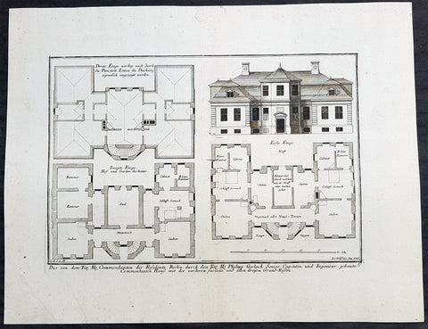
1740 Wolff & Corvinus Antique Arch Plan Officers Quarters, Royal Arsenal, Berlin
Antique Map
- Title : Das von dem Tit. H. Commendanten der Residentz Berlin, durch den Tit. H. Philipp Gerlach Senior Capitain und Ingenieur gebaute Commendaten Hauß mit der vorderen faciata und allen dreyen Grund-Rissen
- Ref #: 93449
- Size: 19 1/2in x 15in (495mm x 390mm)
- Date : 1740
- Condition: (A+) Fine Condition
Description:
This large rare, original copper-plate engraved antique architectural print, view & plan of officers quarters at the Royal Arsenal in Berlin - plate No.17 of 19 - by Johann August Corvinus 1683 - 1738, after Andreas Mayers 1716 - 1782, was published in Eigentliche Abbildung des Prächtigen Königl. Lust Schlosses Charlottenburg, eine Meile von Berlin, sambt dem darhinden im Walde gelegenen schönen Lust Garten
(Set of 16 numbered plates, the first with the title, with plans and views of the buildings and gardens at Charlottenburg, the palace of the King of Prussia on the outskirts of Berlin.) by Jeremias Wolff Erben in 1740.
General Definitions:
Paper thickness and quality: - Heavy and stable
Paper color : - off white
Age of map color: -
Colors used: -
General color appearance: -
Paper size: - 19in x 12 1/2in (490mm x 335mm)
Plate size: - 14 1/2in x 10 1/2in (370mm x 260mm)
Margins: - Min 1in (25mm)
Imperfections:
Margins: - None
Plate area: - None
Verso: - None
Background:
Berlin straddles the banks of the River Spree, which flows into the River Havel (a tributary of the River Elbe) in the western borough of Spandau. Among the citys main topographical features are the many lakes in the western and southeastern boroughs formed by the Spree, Havel, and Dahme rivers (the largest of which is Lake Müggelsee). Due to its location in the European Plain, Berlin is influenced by a temperate seasonal climate. About one-third of the citys area is composed of forests, parks, gardens, rivers, canals and lakes. The city lies in the Central German dialect area, the Berlin dialect being a variant of the Lusatian-New Marchian dialects.
First documented in the 13th century and situated at the crossing of two important historic trade routes, Berlin became the capital of the Margraviate of Brandenburg (1417–1701), the Kingdom of Prussia (1701–1918), the German Empire (1871–1918), the Weimar Republic (1919–1933), and the Third Reich (1933–1945). Berlin in the 1920s was the third-largest municipality in the world. After World War II and its subsequent occupation by the victorious countries, the city was divided; West Berlin became a de facto West German exclave, surrounded by the Berlin Wall (1961–1989) and East German territory. East Berlin was declared capital of East Germany, while Bonn became the West German capital. Following German reunification in 1990, Berlin once again became the capital of all of Germany.
The Thirty Years War between 1618 and 1648 devastated Berlin. One third of its houses were damaged or destroyed, and the city lost half of its population. Frederick William, known as the Great Elector, who had succeeded his father George William as ruler in 1640, initiated a policy of promoting immigration and religious tolerance. With the Edict of Potsdam in 1685, Frederick William offered asylum to the French Huguenots.
By 1700, approximately 30 percent of Berlins residents were French, because of the Huguenot immigration. Many other immigrants came from Bohemia, Poland, and Salzburg.
Since 1618, the Margraviate of Brandenburg had been in personal union with the Duchy of Prussia. In 1701, the dual state formed the Kingdom of Prussia, as Frederick III, Elector of Brandenburg, crowned himself as king Frederick I in Prussia. Berlin became the capital of the new Kingdom, replacing Königsberg. This was a successful attempt to centralise the capital in the very far-flung state, and it was the first time the city began to grow. In 1709, Berlin merged with the four cities of Cölln, Friedrichswerder, Friedrichstadt and Dorotheenstadt under the name Berlin, Haupt- und Residenzstadt Berlin.
In 1740, Frederick II, known as Frederick the Great (1740–1786), came to power. Under the rule of Frederick II, Berlin became a center of the Enlightenment, but also, was briefly occupied during the Seven Years War by the Russian army. Following Frances victory in the War of the Fourth Coalition, Napoleon Bonaparte marched into Berlin in 1806, but granted self-government to the city. In 1815, the city became part of the new Province of Brandenburg.
The Industrial Revolution transformed Berlin during the 19th century; the citys economy and population expanded dramatically, and it became the main railway hub and economic centre of Germany. Additional suburbs soon developed and increased the area and population of Berlin. In 1861, neighbouring suburbs including Wedding, Moabit and several others were incorporated into Berlin. In 1871, Berlin became capital of the newly founded German Empire. In 1881, it became a city district separate from Brandenburg.
Wolff, Jeremais 1663 - 1724
Wolff was an German engraver and publisher. Born in Augsburg, he originally trained as a clock and automat maker, later changing course and opening a small copperplate engraving shop. His success was impressive and became one of the largest European art, print & map publishers in the first half of the 18th century. Wolff employed some of the best engravers of the time and although not an engraver himself, only Wolffs name was recorded on the engravings. Many of his engravers went uncredited for their work. In 1710 Wolff was one of the founder member of the Empire State Academy of Arts in Augsburg.
After his death in 1724, Wolffs publishing business was inherited by his sons and son-in-law, Johann Balthasar Probst (1673–1750) a notable engraver at the time. The firm continued on in Augsburg under the name Jeremias Wolff Erben.
Together with the Nuremberg copperplate engraver Paul Decker , Wolff published a series of engravings showing the war successes of Prince Eugene of Savoy in Italy , southern Germany and the Spanish Netherlands, during the War of the Spanish Succession . The prints are exhibited in the Museum of Military History, in Vienna .
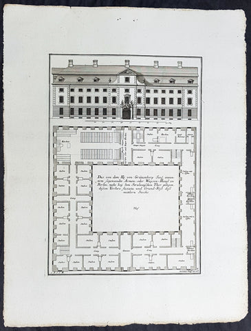
1740 Wolff & Corvinus Antique Arch Print of a Poorhouse near Stralau Gate Berlin
Antique Map
- Title : Das von dem H. von Grünenberg Seel. inventirte sogenandte Armen- oder Waysen-Hauss zu Berlin, nache bey dem Stralauischen Thor gelegen, ....
- Ref #: 93455
- Size: 19in x 12 1/2in (490mm x 335mm)
- Date : 1740
- Condition: (A+) Fine Condition
Description:
This large rare, original copper-plate engraved antique architectural print of the Poorhouse near the old Stralau Gate (Stralauer Tor) in Berlin - plate No. 8 of 16 - by Johann August Corvinus 1683 - 1738, after Andreas Mayers 1716 - 1782, was published in Eigentliche Abbildung des Prächtigen Königl. Lust Schlosses Charlottenburg, eine Meile von Berlin, sambt dem darhinden im Walde gelegenen schönen Lust Garten
(Set of 16 numbered plates, the first with the title, with plans and views of the buildings and gardens at Charlottenburg, the palace of the King of Prussia on the outskirts of Berlin.) by Jeremias Wolff Erben in 1740.
General Definitions:
Paper thickness and quality: - Heavy and stable
Paper color : - off white
Age of map color: -
Colors used: -
General color appearance: -
Paper size: - 19in x 12 1/2in (490mm x 335mm)
Plate size: - 14 1/2in x 10 1/2in (370mm x 260mm)
Margins: - Min 1in (25mm)
Imperfections:
Margins: - None
Plate area: - None
Verso: - None
Background:
Berlin straddles the banks of the River Spree, which flows into the River Havel (a tributary of the River Elbe) in the western borough of Spandau. Among the citys main topographical features are the many lakes in the western and southeastern boroughs formed by the Spree, Havel, and Dahme rivers (the largest of which is Lake Müggelsee). Due to its location in the European Plain, Berlin is influenced by a temperate seasonal climate. About one-third of the citys area is composed of forests, parks, gardens, rivers, canals and lakes. The city lies in the Central German dialect area, the Berlin dialect being a variant of the Lusatian-New Marchian dialects.
First documented in the 13th century and situated at the crossing of two important historic trade routes, Berlin became the capital of the Margraviate of Brandenburg (1417–1701), the Kingdom of Prussia (1701–1918), the German Empire (1871–1918), the Weimar Republic (1919–1933), and the Third Reich (1933–1945). Berlin in the 1920s was the third-largest municipality in the world. After World War II and its subsequent occupation by the victorious countries, the city was divided; West Berlin became a de facto West German exclave, surrounded by the Berlin Wall (1961–1989) and East German territory. East Berlin was declared capital of East Germany, while Bonn became the West German capital. Following German reunification in 1990, Berlin once again became the capital of all of Germany.
The Thirty Years War between 1618 and 1648 devastated Berlin. One third of its houses were damaged or destroyed, and the city lost half of its population. Frederick William, known as the Great Elector, who had succeeded his father George William as ruler in 1640, initiated a policy of promoting immigration and religious tolerance. With the Edict of Potsdam in 1685, Frederick William offered asylum to the French Huguenots.
By 1700, approximately 30 percent of Berlins residents were French, because of the Huguenot immigration. Many other immigrants came from Bohemia, Poland, and Salzburg.
Since 1618, the Margraviate of Brandenburg had been in personal union with the Duchy of Prussia. In 1701, the dual state formed the Kingdom of Prussia, as Frederick III, Elector of Brandenburg, crowned himself as king Frederick I in Prussia. Berlin became the capital of the new Kingdom, replacing Königsberg. This was a successful attempt to centralise the capital in the very far-flung state, and it was the first time the city began to grow. In 1709, Berlin merged with the four cities of Cölln, Friedrichswerder, Friedrichstadt and Dorotheenstadt under the name Berlin, Haupt- und Residenzstadt Berlin.
In 1740, Frederick II, known as Frederick the Great (1740–1786), came to power. Under the rule of Frederick II, Berlin became a center of the Enlightenment, but also, was briefly occupied during the Seven Years War by the Russian army. Following Frances victory in the War of the Fourth Coalition, Napoleon Bonaparte marched into Berlin in 1806, but granted self-government to the city. In 1815, the city became part of the new Province of Brandenburg.
The Industrial Revolution transformed Berlin during the 19th century; the citys economy and population expanded dramatically, and it became the main railway hub and economic centre of Germany. Additional suburbs soon developed and increased the area and population of Berlin. In 1861, neighbouring suburbs including Wedding, Moabit and several others were incorporated into Berlin. In 1871, Berlin became capital of the newly founded German Empire. In 1881, it became a city district separate from Brandenburg.
Wolff, Jeremais 1663 - 1724
Wolff was an German engraver and publisher. Born in Augsburg, he originally trained as a clock and automat maker, later changing course and opening a small copperplate engraving shop. His success was impressive and became one of the largest European art, print & map publishers in the first half of the 18th century. Wolff employed some of the best engravers of the time and although not an engraver himself, only Wolffs name was recorded on the engravings. Many of his engravers went uncredited for their work. In 1710 Wolff was one of the founder member of the Empire State Academy of Arts in Augsburg.
After his death in 1724, Wolffs publishing business was inherited by his sons and son-in-law, Johann Balthasar Probst (1673–1750) a notable engraver at the time. The firm continued on in Augsburg under the name Jeremias Wolff Erben.
Together with the Nuremberg copperplate engraver Paul Decker , Wolff published a series of engravings showing the war successes of Prince Eugene of Savoy in Italy , southern Germany and the Spanish Netherlands, during the War of the Spanish Succession . The prints are exhibited in the Museum of Military History, in Vienna .
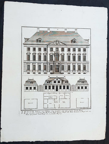
1740 Wolff & Corvinus Antique Arch Print of Berlin Mansions by A. von Schlütter
Antique Map
- Title : A. Ist ein von H. Andreas von Schlütter Seel. inventirt- und auff gebautes Landt-Hauss. B. Ist ein von dem renomirten Bau-Werck- und Raths Zimmer-Meister Joh. Mich. Kemmeter, in Riegel oder Holtz auff gebautes Land-Hauß oder so genandte Meyerey
- Ref #: 93445
- Size: 19in x 12 1/2in (490mm x 335mm)
- Date : 1740
- Condition: (A+) Fine Condition
Description:
This large rare, original copper-plate engraved antique architectural print of 18th century Mansions in Berlin designed by Andreas von Schlütter - plate No. 9 of 16 - by Johann August Corvinus 1683 - 1738, after Andreas Mayers 1716 - 1782, was published in Eigentliche Abbildung des Prächtigen Königl. Lust Schlosses Charlottenburg, eine Meile von Berlin, sambt dem darhinden im Walde gelegenen schönen Lust Garten
(Set of 16 numbered plates, the first with the title, with plans and views of the buildings and gardens at Charlottenburg, the palace of the King of Prussia on the outskirts of Berlin.) by Jeremias Wolff Erben in 1740.
General Definitions:
Paper thickness and quality: - Heavy and stable
Paper color : - off white
Age of map color: -
Colors used: -
General color appearance: -
Paper size: - 19in x 12 1/2in (490mm x 335mm)
Plate size: - 14 1/2in x 10 1/2in (370mm x 260mm)
Margins: - Min 1in (25mm)
Imperfections:
Margins: - None
Plate area: - None
Verso: - None
Background:
Berlin straddles the banks of the River Spree, which flows into the River Havel (a tributary of the River Elbe) in the western borough of Spandau. Among the citys main topographical features are the many lakes in the western and southeastern boroughs formed by the Spree, Havel, and Dahme rivers (the largest of which is Lake Müggelsee). Due to its location in the European Plain, Berlin is influenced by a temperate seasonal climate. About one-third of the citys area is composed of forests, parks, gardens, rivers, canals and lakes. The city lies in the Central German dialect area, the Berlin dialect being a variant of the Lusatian-New Marchian dialects.
First documented in the 13th century and situated at the crossing of two important historic trade routes, Berlin became the capital of the Margraviate of Brandenburg (1417–1701), the Kingdom of Prussia (1701–1918), the German Empire (1871–1918), the Weimar Republic (1919–1933), and the Third Reich (1933–1945). Berlin in the 1920s was the third-largest municipality in the world. After World War II and its subsequent occupation by the victorious countries, the city was divided; West Berlin became a de facto West German exclave, surrounded by the Berlin Wall (1961–1989) and East German territory. East Berlin was declared capital of East Germany, while Bonn became the West German capital. Following German reunification in 1990, Berlin once again became the capital of all of Germany.
The Thirty Years War between 1618 and 1648 devastated Berlin. One third of its houses were damaged or destroyed, and the city lost half of its population. Frederick William, known as the Great Elector, who had succeeded his father George William as ruler in 1640, initiated a policy of promoting immigration and religious tolerance. With the Edict of Potsdam in 1685, Frederick William offered asylum to the French Huguenots.
By 1700, approximately 30 percent of Berlins residents were French, because of the Huguenot immigration. Many other immigrants came from Bohemia, Poland, and Salzburg.
Since 1618, the Margraviate of Brandenburg had been in personal union with the Duchy of Prussia. In 1701, the dual state formed the Kingdom of Prussia, as Frederick III, Elector of Brandenburg, crowned himself as king Frederick I in Prussia. Berlin became the capital of the new Kingdom, replacing Königsberg. This was a successful attempt to centralise the capital in the very far-flung state, and it was the first time the city began to grow. In 1709, Berlin merged with the four cities of Cölln, Friedrichswerder, Friedrichstadt and Dorotheenstadt under the name Berlin, Haupt- und Residenzstadt Berlin.
In 1740, Frederick II, known as Frederick the Great (1740–1786), came to power. Under the rule of Frederick II, Berlin became a center of the Enlightenment, but also, was briefly occupied during the Seven Years War by the Russian army. Following Frances victory in the War of the Fourth Coalition, Napoleon Bonaparte marched into Berlin in 1806, but granted self-government to the city. In 1815, the city became part of the new Province of Brandenburg.
The Industrial Revolution transformed Berlin during the 19th century; the citys economy and population expanded dramatically, and it became the main railway hub and economic centre of Germany. Additional suburbs soon developed and increased the area and population of Berlin. In 1861, neighbouring suburbs including Wedding, Moabit and several others were incorporated into Berlin. In 1871, Berlin became capital of the newly founded German Empire. In 1881, it became a city district separate from Brandenburg.
Wolff, Jeremais 1663 - 1724
Wolff was an German engraver and publisher. Born in Augsburg, he originally trained as a clock and automat maker, later changing course and opening a small copperplate engraving shop. His success was impressive and became one of the largest European art, print & map publishers in the first half of the 18th century. Wolff employed some of the best engravers of the time and although not an engraver himself, only Wolffs name was recorded on the engravings. Many of his engravers went uncredited for their work. In 1710 Wolff was one of the founder member of the Empire State Academy of Arts in Augsburg.
After his death in 1724, Wolffs publishing business was inherited by his sons and son-in-law, Johann Balthasar Probst (1673–1750) a notable engraver at the time. The firm continued on in Augsburg under the name Jeremias Wolff Erben.
Together with the Nuremberg copperplate engraver Paul Decker , Wolff published a series of engravings showing the war successes of Prince Eugene of Savoy in Italy , southern Germany and the Spanish Netherlands, during the War of the Spanish Succession . The prints are exhibited in the Museum of Military History, in Vienna .
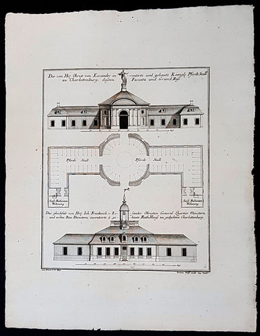
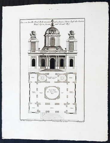
1740 Wolff & Corvinus Antique Arch Print of Charlottenburg Palace Stables Berlin
Antique Map
- Title : Der von Hr. Obrist von Eosander inventirte und gebaute Königl. Pferdt Stall zu Charlottenburg, dessen Faciata und Grund Riss. - Das gleichfals von Hr. Joh. Friederich v. Eosander Obristen General Quartier Meistern, und ersten Bau Directorn inventierte und gebaute Rath Hauss zu gedachten Charlottenburg
- Ref #: 93453
- Size: 19in x 12 1/2in (490mm x 335mm)
- Date : 1740
- Condition: (A+) Fine Condition
Description:
This large rare, original copper-plate engraved antique architectural print of the Royal Horse Stables at Charlottenburg Palace, Berlin - plate No. 11 of 16 - by Johann August Corvinus 1683 - 1738, after Andreas Mayers 1716 - 1782, was published in Eigentliche Abbildung des Prächtigen Königl. Lust Schlosses Charlottenburg, eine Meile von Berlin, sambt dem darhinden im Walde gelegenen schönen Lust Garten
(Set of 16 numbered plates, the first with the title, with plans and views of the buildings and gardens at Charlottenburg, the palace of the King of Prussia on the outskirts of Berlin.) by Jeremias Wolff Erben in 1740.
General Definitions:
Paper thickness and quality: - Heavy and stable
Paper color : - off white
Age of map color: -
Colors used: -
General color appearance: -
Paper size: - 19in x 12 1/2in (490mm x 335mm)
Plate size: - 14 1/2in x 10 1/2in (370mm x 260mm)
Margins: - Min 1in (25mm)
Imperfections:
Margins: - None
Plate area: - None
Verso: - None
Background:
Berlin straddles the banks of the River Spree, which flows into the River Havel (a tributary of the River Elbe) in the western borough of Spandau. Among the citys main topographical features are the many lakes in the western and southeastern boroughs formed by the Spree, Havel, and Dahme rivers (the largest of which is Lake Müggelsee). Due to its location in the European Plain, Berlin is influenced by a temperate seasonal climate. About one-third of the citys area is composed of forests, parks, gardens, rivers, canals and lakes. The city lies in the Central German dialect area, the Berlin dialect being a variant of the Lusatian-New Marchian dialects.
First documented in the 13th century and situated at the crossing of two important historic trade routes, Berlin became the capital of the Margraviate of Brandenburg (1417–1701), the Kingdom of Prussia (1701–1918), the German Empire (1871–1918), the Weimar Republic (1919–1933), and the Third Reich (1933–1945). Berlin in the 1920s was the third-largest municipality in the world. After World War II and its subsequent occupation by the victorious countries, the city was divided; West Berlin became a de facto West German exclave, surrounded by the Berlin Wall (1961–1989) and East German territory. East Berlin was declared capital of East Germany, while Bonn became the West German capital. Following German reunification in 1990, Berlin once again became the capital of all of Germany.
The Thirty Years War between 1618 and 1648 devastated Berlin. One third of its houses were damaged or destroyed, and the city lost half of its population. Frederick William, known as the Great Elector, who had succeeded his father George William as ruler in 1640, initiated a policy of promoting immigration and religious tolerance. With the Edict of Potsdam in 1685, Frederick William offered asylum to the French Huguenots.
By 1700, approximately 30 percent of Berlins residents were French, because of the Huguenot immigration. Many other immigrants came from Bohemia, Poland, and Salzburg.
Since 1618, the Margraviate of Brandenburg had been in personal union with the Duchy of Prussia. In 1701, the dual state formed the Kingdom of Prussia, as Frederick III, Elector of Brandenburg, crowned himself as king Frederick I in Prussia. Berlin became the capital of the new Kingdom, replacing Königsberg. This was a successful attempt to centralise the capital in the very far-flung state, and it was the first time the city began to grow. In 1709, Berlin merged with the four cities of Cölln, Friedrichswerder, Friedrichstadt and Dorotheenstadt under the name Berlin, Haupt- und Residenzstadt Berlin.
In 1740, Frederick II, known as Frederick the Great (1740–1786), came to power. Under the rule of Frederick II, Berlin became a center of the Enlightenment, but also, was briefly occupied during the Seven Years War by the Russian army. Following Frances victory in the War of the Fourth Coalition, Napoleon Bonaparte marched into Berlin in 1806, but granted self-government to the city. In 1815, the city became part of the new Province of Brandenburg.
The Industrial Revolution transformed Berlin during the 19th century; the citys economy and population expanded dramatically, and it became the main railway hub and economic centre of Germany. Additional suburbs soon developed and increased the area and population of Berlin. In 1861, neighbouring suburbs including Wedding, Moabit and several others were incorporated into Berlin. In 1871, Berlin became capital of the newly founded German Empire. In 1881, it became a city district separate from Brandenburg.
Wolff, Jeremais 1663 - 1724
Wolff was an German engraver and publisher. Born in Augsburg, he originally trained as a clock and automat maker, later changing course and opening a small copperplate engraving shop. His success was impressive and became one of the largest European art, print & map publishers in the first half of the 18th century. Wolff employed some of the best engravers of the time and although not an engraver himself, only Wolffs name was recorded on the engravings. Many of his engravers went uncredited for their work. In 1710 Wolff was one of the founder member of the Empire State Academy of Arts in Augsburg.
After his death in 1724, Wolffs publishing business was inherited by his sons and son-in-law, Johann Balthasar Probst (1673–1750) a notable engraver at the time. The firm continued on in Augsburg under the name Jeremias Wolff Erben.
Together with the Nuremberg copperplate engraver Paul Decker , Wolff published a series of engravings showing the war successes of Prince Eugene of Savoy in Italy , southern Germany and the Spanish Netherlands, during the War of the Spanish Succession . The prints are exhibited in the Museum of Military History, in Vienna .
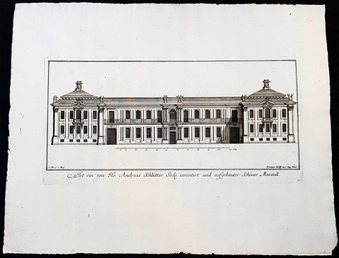
1740 Wolff & Corvinus Antique Arch Print of Charlottenburg Palace Stables Berlin
Antique Map
- Title : Ist ein von Hr. Andreas Schlütter Seel. inventirt und aufgebauer Schöner Marstall Datierung
- Ref #: 93447
- Size: 19in x 12 1/2in (490mm x 335mm)
- Date : 1740
- Condition: (A+) Fine Condition
Description:
This large rare, original copper-plate engraved antique architectural print, view of the facade of the Charlottenburg Palace stables in Berlin - plate No.15 of 16 - by Johann August Corvinus 1683 - 1738, after Andreas Mayers 1716 - 1782, was published in Eigentliche Abbildung des Prächtigen Königl. Lust Schlosses Charlottenburg, eine Meile von Berlin, sambt dem darhinden im Walde gelegenen schönen Lust Garten
(Set of 16 numbered plates, the first with the title, with plans and views of the buildings and gardens at Charlottenburg, the palace of the King of Prussia on the outskirts of Berlin.) by Jeremias Wolff Erben in 1740.
General Definitions:
Paper thickness and quality: - Heavy and stable
Paper color : - off white
Age of map color: -
Colors used: -
General color appearance: -
Paper size: - 19in x 12 1/2in (490mm x 335mm)
Plate size: - 14 1/2in x 10 1/2in (370mm x 260mm)
Margins: - Min 1in (25mm)
Imperfections:
Margins: - None
Plate area: - None
Verso: - None
Background:
Berlin straddles the banks of the River Spree, which flows into the River Havel (a tributary of the River Elbe) in the western borough of Spandau. Among the citys main topographical features are the many lakes in the western and southeastern boroughs formed by the Spree, Havel, and Dahme rivers (the largest of which is Lake Müggelsee). Due to its location in the European Plain, Berlin is influenced by a temperate seasonal climate. About one-third of the citys area is composed of forests, parks, gardens, rivers, canals and lakes. The city lies in the Central German dialect area, the Berlin dialect being a variant of the Lusatian-New Marchian dialects.
First documented in the 13th century and situated at the crossing of two important historic trade routes, Berlin became the capital of the Margraviate of Brandenburg (1417–1701), the Kingdom of Prussia (1701–1918), the German Empire (1871–1918), the Weimar Republic (1919–1933), and the Third Reich (1933–1945). Berlin in the 1920s was the third-largest municipality in the world. After World War II and its subsequent occupation by the victorious countries, the city was divided; West Berlin became a de facto West German exclave, surrounded by the Berlin Wall (1961–1989) and East German territory. East Berlin was declared capital of East Germany, while Bonn became the West German capital. Following German reunification in 1990, Berlin once again became the capital of all of Germany.
The Thirty Years War between 1618 and 1648 devastated Berlin. One third of its houses were damaged or destroyed, and the city lost half of its population. Frederick William, known as the Great Elector, who had succeeded his father George William as ruler in 1640, initiated a policy of promoting immigration and religious tolerance. With the Edict of Potsdam in 1685, Frederick William offered asylum to the French Huguenots.
By 1700, approximately 30 percent of Berlins residents were French, because of the Huguenot immigration. Many other immigrants came from Bohemia, Poland, and Salzburg.
Since 1618, the Margraviate of Brandenburg had been in personal union with the Duchy of Prussia. In 1701, the dual state formed the Kingdom of Prussia, as Frederick III, Elector of Brandenburg, crowned himself as king Frederick I in Prussia. Berlin became the capital of the new Kingdom, replacing Königsberg. This was a successful attempt to centralise the capital in the very far-flung state, and it was the first time the city began to grow. In 1709, Berlin merged with the four cities of Cölln, Friedrichswerder, Friedrichstadt and Dorotheenstadt under the name Berlin, Haupt- und Residenzstadt Berlin.
In 1740, Frederick II, known as Frederick the Great (1740–1786), came to power. Under the rule of Frederick II, Berlin became a center of the Enlightenment, but also, was briefly occupied during the Seven Years War by the Russian army. Following Frances victory in the War of the Fourth Coalition, Napoleon Bonaparte marched into Berlin in 1806, but granted self-government to the city. In 1815, the city became part of the new Province of Brandenburg.
The Industrial Revolution transformed Berlin during the 19th century; the citys economy and population expanded dramatically, and it became the main railway hub and economic centre of Germany. Additional suburbs soon developed and increased the area and population of Berlin. In 1861, neighbouring suburbs including Wedding, Moabit and several others were incorporated into Berlin. In 1871, Berlin became capital of the newly founded German Empire. In 1881, it became a city district separate from Brandenburg.
Wolff, Jeremais 1663 - 1724
Wolff was an German engraver and publisher. Born in Augsburg, he originally trained as a clock and automat maker, later changing course and opening a small copperplate engraving shop. His success was impressive and became one of the largest European art, print & map publishers in the first half of the 18th century. Wolff employed some of the best engravers of the time and although not an engraver himself, only Wolffs name was recorded on the engravings. Many of his engravers went uncredited for their work. In 1710 Wolff was one of the founder member of the Empire State Academy of Arts in Augsburg.
After his death in 1724, Wolffs publishing business was inherited by his sons and son-in-law, Johann Balthasar Probst (1673–1750) a notable engraver at the time. The firm continued on in Augsburg under the name Jeremias Wolff Erben.
Together with the Nuremberg copperplate engraver Paul Decker , Wolff published a series of engravings showing the war successes of Prince Eugene of Savoy in Italy , southern Germany and the Spanish Netherlands, during the War of the Spanish Succession . The prints are exhibited in the Museum of Military History, in Vienna .
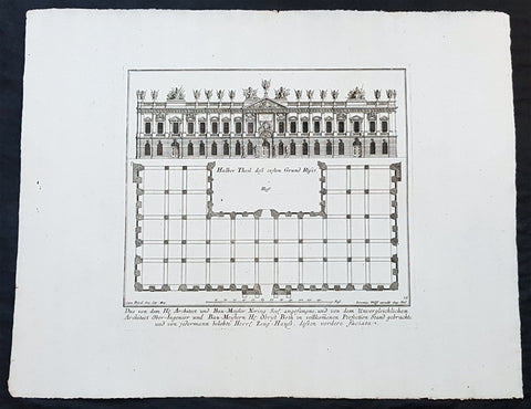
1740 Wolff & Corvinus Antique Arch Print of The Royal Arsenal in Berlin Germany
Antique Map
- Title : Das von dem H. Architect und Bau-Meister Nering Seel. angefangne, und von dem unvergleichlichen Architect Ober-Ingenier und Bau-Meistern H. Obrist Both in vollkommenen Perfection Stand gebrachte und von jedermann belobte Herr. Zeug-Haus, dessen vordere faciata
- Ref #: 93454
- Size: 19in x 12 1/2in (490mm x 335mm)
- Date : 1740
- Condition: (A+) Fine Condition
Description:
This large rare, original copper-plate engraved antique architectural print, view & plan of The Royal Arsenal in Berlin Houses - plate No.13 of 16 - by Johann August Corvinus 1683 - 1738, after Andreas Mayers 1716 - 1782, was published in Eigentliche Abbildung des Prächtigen Königl. Lust Schlosses Charlottenburg, eine Meile von Berlin, sambt dem darhinden im Walde gelegenen schönen Lust Garten
(Set of 16 numbered plates, the first with the title, with plans and views of the buildings and gardens at Charlottenburg, the palace of the King of Prussia on the outskirts of Berlin.) by Jeremias Wolff Erben in 1740.
General Definitions:
Paper thickness and quality: - Heavy and stable
Paper color : - off white
Age of map color: -
Colors used: -
General color appearance: -
Paper size: - 19in x 12 1/2in (490mm x 335mm)
Plate size: - 14 1/2in x 10 1/2in (370mm x 260mm)
Margins: - Min 1in (25mm)
Imperfections:
Margins: - None
Plate area: - None
Verso: - None
Background:
Berlin straddles the banks of the River Spree, which flows into the River Havel (a tributary of the River Elbe) in the western borough of Spandau. Among the citys main topographical features are the many lakes in the western and southeastern boroughs formed by the Spree, Havel, and Dahme rivers (the largest of which is Lake Müggelsee). Due to its location in the European Plain, Berlin is influenced by a temperate seasonal climate. About one-third of the citys area is composed of forests, parks, gardens, rivers, canals and lakes. The city lies in the Central German dialect area, the Berlin dialect being a variant of the Lusatian-New Marchian dialects.
First documented in the 13th century and situated at the crossing of two important historic trade routes, Berlin became the capital of the Margraviate of Brandenburg (1417–1701), the Kingdom of Prussia (1701–1918), the German Empire (1871–1918), the Weimar Republic (1919–1933), and the Third Reich (1933–1945). Berlin in the 1920s was the third-largest municipality in the world. After World War II and its subsequent occupation by the victorious countries, the city was divided; West Berlin became a de facto West German exclave, surrounded by the Berlin Wall (1961–1989) and East German territory. East Berlin was declared capital of East Germany, while Bonn became the West German capital. Following German reunification in 1990, Berlin once again became the capital of all of Germany.
The Thirty Years War between 1618 and 1648 devastated Berlin. One third of its houses were damaged or destroyed, and the city lost half of its population. Frederick William, known as the Great Elector, who had succeeded his father George William as ruler in 1640, initiated a policy of promoting immigration and religious tolerance. With the Edict of Potsdam in 1685, Frederick William offered asylum to the French Huguenots.
By 1700, approximately 30 percent of Berlins residents were French, because of the Huguenot immigration. Many other immigrants came from Bohemia, Poland, and Salzburg.
Since 1618, the Margraviate of Brandenburg had been in personal union with the Duchy of Prussia. In 1701, the dual state formed the Kingdom of Prussia, as Frederick III, Elector of Brandenburg, crowned himself as king Frederick I in Prussia. Berlin became the capital of the new Kingdom, replacing Königsberg. This was a successful attempt to centralise the capital in the very far-flung state, and it was the first time the city began to grow. In 1709, Berlin merged with the four cities of Cölln, Friedrichswerder, Friedrichstadt and Dorotheenstadt under the name Berlin, Haupt- und Residenzstadt Berlin.
In 1740, Frederick II, known as Frederick the Great (1740–1786), came to power. Under the rule of Frederick II, Berlin became a center of the Enlightenment, but also, was briefly occupied during the Seven Years War by the Russian army. Following Frances victory in the War of the Fourth Coalition, Napoleon Bonaparte marched into Berlin in 1806, but granted self-government to the city. In 1815, the city became part of the new Province of Brandenburg.
The Industrial Revolution transformed Berlin during the 19th century; the citys economy and population expanded dramatically, and it became the main railway hub and economic centre of Germany. Additional suburbs soon developed and increased the area and population of Berlin. In 1861, neighbouring suburbs including Wedding, Moabit and several others were incorporated into Berlin. In 1871, Berlin became capital of the newly founded German Empire. In 1881, it became a city district separate from Brandenburg.
Wolff, Jeremais 1663 - 1724
Wolff was an German engraver and publisher. Born in Augsburg, he originally trained as a clock and automat maker, later changing course and opening a small copperplate engraving shop. His success was impressive and became one of the largest European art, print & map publishers in the first half of the 18th century. Wolff employed some of the best engravers of the time and although not an engraver himself, only Wolffs name was recorded on the engravings. Many of his engravers went uncredited for their work. In 1710 Wolff was one of the founder member of the Empire State Academy of Arts in Augsburg.
After his death in 1724, Wolffs publishing business was inherited by his sons and son-in-law, Johann Balthasar Probst (1673–1750) a notable engraver at the time. The firm continued on in Augsburg under the name Jeremias Wolff Erben.
Together with the Nuremberg copperplate engraver Paul Decker , Wolff published a series of engravings showing the war successes of Prince Eugene of Savoy in Italy , southern Germany and the Spanish Netherlands, during the War of the Spanish Succession . The prints are exhibited in the Museum of Military History, in Vienna .
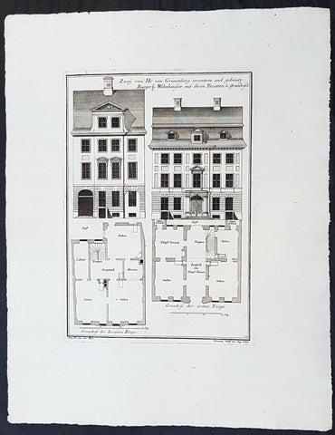
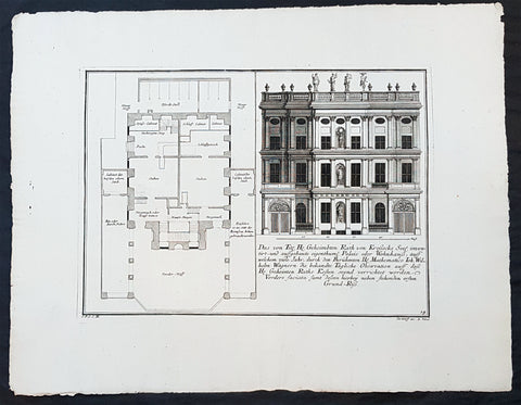
1740 Wolff & Corvinus Antique Arch Print Plans of Residential Houses in Berlin
Antique Map
- Title : Zwey von Hr. von Grünenberg inventirte und gebaute Burgerl. Wohnhäusser mit ihren Faciaten u. Grundrissen
- Ref #: 93450
- Size: 19in x 12 1/2in (490mm x 335mm)
- Date : 1740
- Condition: (A+) Fine Condition
Description:
This large rare, original copper-plate engraved antique architectural print plans of Berlin Houses - plate No. 12 of 16 - by Johann August Corvinus 1683 - 1738, after Andreas Mayers 1716 - 1782, was published in Eigentliche Abbildung des Prächtigen Königl. Lust Schlosses Charlottenburg, eine Meile von Berlin, sambt dem darhinden im Walde gelegenen schönen Lust Garten
(Set of 16 numbered plates, the first with the title, with plans and views of the buildings and gardens at Charlottenburg, the palace of the King of Prussia on the outskirts of Berlin.) by Jeremias Wolff Erben in 1740.
General Definitions:
Paper thickness and quality: - Heavy and stable
Paper color : - off white
Age of map color: -
Colors used: -
General color appearance: -
Paper size: - 19in x 12 1/2in (490mm x 335mm)
Plate size: - 14 1/2in x 10 1/2in (370mm x 260mm)
Margins: - Min 1in (25mm)
Imperfections:
Margins: - None
Plate area: - None
Verso: - None
Background:
Berlin straddles the banks of the River Spree, which flows into the River Havel (a tributary of the River Elbe) in the western borough of Spandau. Among the citys main topographical features are the many lakes in the western and southeastern boroughs formed by the Spree, Havel, and Dahme rivers (the largest of which is Lake Müggelsee). Due to its location in the European Plain, Berlin is influenced by a temperate seasonal climate. About one-third of the citys area is composed of forests, parks, gardens, rivers, canals and lakes. The city lies in the Central German dialect area, the Berlin dialect being a variant of the Lusatian-New Marchian dialects.
First documented in the 13th century and situated at the crossing of two important historic trade routes, Berlin became the capital of the Margraviate of Brandenburg (1417–1701), the Kingdom of Prussia (1701–1918), the German Empire (1871–1918), the Weimar Republic (1919–1933), and the Third Reich (1933–1945). Berlin in the 1920s was the third-largest municipality in the world. After World War II and its subsequent occupation by the victorious countries, the city was divided; West Berlin became a de facto West German exclave, surrounded by the Berlin Wall (1961–1989) and East German territory. East Berlin was declared capital of East Germany, while Bonn became the West German capital. Following German reunification in 1990, Berlin once again became the capital of all of Germany.
The Thirty Years War between 1618 and 1648 devastated Berlin. One third of its houses were damaged or destroyed, and the city lost half of its population. Frederick William, known as the Great Elector, who had succeeded his father George William as ruler in 1640, initiated a policy of promoting immigration and religious tolerance. With the Edict of Potsdam in 1685, Frederick William offered asylum to the French Huguenots.
By 1700, approximately 30 percent of Berlins residents were French, because of the Huguenot immigration. Many other immigrants came from Bohemia, Poland, and Salzburg.
Since 1618, the Margraviate of Brandenburg had been in personal union with the Duchy of Prussia. In 1701, the dual state formed the Kingdom of Prussia, as Frederick III, Elector of Brandenburg, crowned himself as king Frederick I in Prussia. Berlin became the capital of the new Kingdom, replacing Königsberg. This was a successful attempt to centralise the capital in the very far-flung state, and it was the first time the city began to grow. In 1709, Berlin merged with the four cities of Cölln, Friedrichswerder, Friedrichstadt and Dorotheenstadt under the name Berlin, Haupt- und Residenzstadt Berlin.
In 1740, Frederick II, known as Frederick the Great (1740–1786), came to power. Under the rule of Frederick II, Berlin became a center of the Enlightenment, but also, was briefly occupied during the Seven Years War by the Russian army. Following Frances victory in the War of the Fourth Coalition, Napoleon Bonaparte marched into Berlin in 1806, but granted self-government to the city. In 1815, the city became part of the new Province of Brandenburg.
The Industrial Revolution transformed Berlin during the 19th century; the citys economy and population expanded dramatically, and it became the main railway hub and economic centre of Germany. Additional suburbs soon developed and increased the area and population of Berlin. In 1861, neighbouring suburbs including Wedding, Moabit and several others were incorporated into Berlin. In 1871, Berlin became capital of the newly founded German Empire. In 1881, it became a city district separate from Brandenburg.
Wolff, Jeremais 1663 - 1724
Wolff was an German engraver and publisher. Born in Augsburg, he originally trained as a clock and automat maker, later changing course and opening a small copperplate engraving shop. His success was impressive and became one of the largest European art, print & map publishers in the first half of the 18th century. Wolff employed some of the best engravers of the time and although not an engraver himself, only Wolffs name was recorded on the engravings. Many of his engravers went uncredited for their work. In 1710 Wolff was one of the founder member of the Empire State Academy of Arts in Augsburg.
After his death in 1724, Wolffs publishing business was inherited by his sons and son-in-law, Johann Balthasar Probst (1673–1750) a notable engraver at the time. The firm continued on in Augsburg under the name Jeremias Wolff Erben.
Together with the Nuremberg copperplate engraver Paul Decker , Wolff published a series of engravings showing the war successes of Prince Eugene of Savoy in Italy , southern Germany and the Spanish Netherlands, during the War of the Spanish Succession . The prints are exhibited in the Museum of Military History, in Vienna .
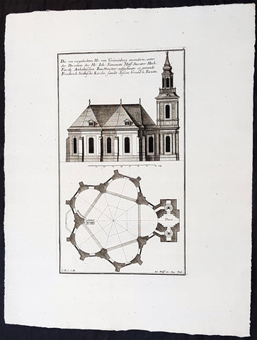
1740 Wolff & Corvinus Antique Arch. Print Jerusalem Church Friedrichstadt.Berlin
Antique Map
- Title : Die von vorgedachten Hr. von Grünenberg invendierte, unter der Direction des Hr. Ioh. Simonetti Hoff Stucator Hoch-Fürstl. Anhaltischen BauMeister aufgebaute so genande Friderich Stättische Kirche sampt dessen Grund u. Faciata.
- Ref #: 93458
- Size: 19in x 12 1/2in (490mm x 335mm)
- Date : 1740
- Condition: (A+) Fine Condition
Description:
This large rare, original copper-plate engraved antique architectural print of the Parochialkirche (literally the Reformed parochial church) in the Mitte suburb of Berlin - plate No. 7 of 16 - by Johann August Corvinus 1683 - 1738, after Andreas Mayers 1716 - 1782, was published in Eigentliche Abbildung des Prächtigen Königl. Lust Schlosses Charlottenburg, eine Meile von Berlin, sambt dem darhinden im Walde gelegenen schönen Lust Garten
(Set of 16 numbered plates, the first with the title, with plans and views of the buildings and gardens at Charlottenburg, the palace of the King of Prussia on the outskirts of Berlin.) by Jeremias Wolff Erben in 1740.
General Definitions:
Paper thickness and quality: - Heavy and stable
Paper color : - off white
Age of map color: -
Colors used: -
General color appearance: -
Paper size: - 19in x 12 1/2in (490mm x 335mm)
Plate size: - 14 1/2in x 10 1/2in (370mm x 260mm)
Margins: - Min 1in (25mm)
Imperfections:
Margins: - None
Plate area: - None
Verso: - None
Background:
Berlin straddles the banks of the River Spree, which flows into the River Havel (a tributary of the River Elbe) in the western borough of Spandau. Among the citys main topographical features are the many lakes in the western and southeastern boroughs formed by the Spree, Havel, and Dahme rivers (the largest of which is Lake Müggelsee). Due to its location in the European Plain, Berlin is influenced by a temperate seasonal climate. About one-third of the citys area is composed of forests, parks, gardens, rivers, canals and lakes. The city lies in the Central German dialect area, the Berlin dialect being a variant of the Lusatian-New Marchian dialects.
First documented in the 13th century and situated at the crossing of two important historic trade routes, Berlin became the capital of the Margraviate of Brandenburg (1417–1701), the Kingdom of Prussia (1701–1918), the German Empire (1871–1918), the Weimar Republic (1919–1933), and the Third Reich (1933–1945). Berlin in the 1920s was the third-largest municipality in the world. After World War II and its subsequent occupation by the victorious countries, the city was divided; West Berlin became a de facto West German exclave, surrounded by the Berlin Wall (1961–1989) and East German territory. East Berlin was declared capital of East Germany, while Bonn became the West German capital. Following German reunification in 1990, Berlin once again became the capital of all of Germany.
The Thirty Years War between 1618 and 1648 devastated Berlin. One third of its houses were damaged or destroyed, and the city lost half of its population. Frederick William, known as the Great Elector, who had succeeded his father George William as ruler in 1640, initiated a policy of promoting immigration and religious tolerance. With the Edict of Potsdam in 1685, Frederick William offered asylum to the French Huguenots.
By 1700, approximately 30 percent of Berlins residents were French, because of the Huguenot immigration. Many other immigrants came from Bohemia, Poland, and Salzburg.
Since 1618, the Margraviate of Brandenburg had been in personal union with the Duchy of Prussia. In 1701, the dual state formed the Kingdom of Prussia, as Frederick III, Elector of Brandenburg, crowned himself as king Frederick I in Prussia. Berlin became the capital of the new Kingdom, replacing Königsberg. This was a successful attempt to centralise the capital in the very far-flung state, and it was the first time the city began to grow. In 1709, Berlin merged with the four cities of Cölln, Friedrichswerder, Friedrichstadt and Dorotheenstadt under the name Berlin, Haupt- und Residenzstadt Berlin.
In 1740, Frederick II, known as Frederick the Great (1740–1786), came to power. Under the rule of Frederick II, Berlin became a center of the Enlightenment, but also, was briefly occupied during the Seven Years War by the Russian army. Following Frances victory in the War of the Fourth Coalition, Napoleon Bonaparte marched into Berlin in 1806, but granted self-government to the city. In 1815, the city became part of the new Province of Brandenburg.
The Industrial Revolution transformed Berlin during the 19th century; the citys economy and population expanded dramatically, and it became the main railway hub and economic centre of Germany. Additional suburbs soon developed and increased the area and population of Berlin. In 1861, neighbouring suburbs including Wedding, Moabit and several others were incorporated into Berlin. In 1871, Berlin became capital of the newly founded German Empire. In 1881, it became a city district separate from Brandenburg.
Wolff, Jeremais 1663 - 1724
Wolff was an German engraver and publisher. Born in Augsburg, he originally trained as a clock and automat maker, later changing course and opening a small copperplate engraving shop. His success was impressive and became one of the largest European art, print & map publishers in the first half of the 18th century. Wolff employed some of the best engravers of the time and although not an engraver himself, only Wolffs name was recorded on the engravings. Many of his engravers went uncredited for their work. In 1710 Wolff was one of the founder member of the Empire State Academy of Arts in Augsburg.
After his death in 1724, Wolffs publishing business was inherited by his sons and son-in-law, Johann Balthasar Probst (1673–1750) a notable engraver at the time. The firm continued on in Augsburg under the name Jeremias Wolff Erben.
Together with the Nuremberg copperplate engraver Paul Decker , Wolff published a series of engravings showing the war successes of Prince Eugene of Savoy in Italy , southern Germany and the Spanish Netherlands, during the War of the Spanish Succession . The prints are exhibited in the Museum of Military History, in Vienna .
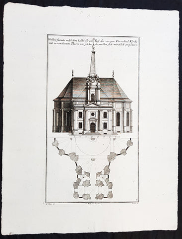
1740 Wolff & Corvinus Antique Arch. Print of the Parochialkirche in Mitte Berlin
Antique Map
- Title : Vordere faciata nebst dem halben Grund Riß der vorigen Parochial-Kirche mit verändertem Thurn wie solcher dermahlen sich würklich presentiert. Frontriß, darunter der halbe Grundriß.
- Ref #: 93459
- Size: 19in x 12 1/2in (490mm x 335mm)
- Date : 1740
- Condition: (A+) Fine Condition
Description:
This large rare, original copper-plate engraved antique architectural print of the Parochialkirche (literally the Reformed parochial church) in the Mitte suburb of Berlin - plate No. 6 of 16 - by Johann August Corvinus 1683 - 1738, after Andreas Mayers 1716 - 1782, was published in Eigentliche Abbildung des Prächtigen Königl. Lust Schlosses Charlottenburg, eine Meile von Berlin, sambt dem darhinden im Walde gelegenen schönen Lust Garten.
(Set of 16 numbered plates, the first with the title, with plans and views of the buildings and gardens at Charlottenburg, the palace of the King of Prussia on the outskirts of Berlin.) by Jeremias Wolff Erben in 1740.
General Definitions:
Paper thickness and quality: - Heavy and stable
Paper color : - off white
Age of map color: -
Colors used: -
General color appearance: -
Paper size: - 19in x 12 1/2in (490mm x 335mm)
Plate size: - 14 1/2in x 10 1/2in (370mm x 260mm)
Margins: - Min 1in (25mm)
Imperfections:
Margins: - None
Plate area: - None
Verso: - None
Background:
Berlin straddles the banks of the River Spree, which flows into the River Havel (a tributary of the River Elbe) in the western borough of Spandau. Among the citys main topographical features are the many lakes in the western and southeastern boroughs formed by the Spree, Havel, and Dahme rivers (the largest of which is Lake Müggelsee). Due to its location in the European Plain, Berlin is influenced by a temperate seasonal climate. About one-third of the citys area is composed of forests, parks, gardens, rivers, canals and lakes. The city lies in the Central German dialect area, the Berlin dialect being a variant of the Lusatian-New Marchian dialects.
First documented in the 13th century and situated at the crossing of two important historic trade routes, Berlin became the capital of the Margraviate of Brandenburg (1417–1701), the Kingdom of Prussia (1701–1918), the German Empire (1871–1918), the Weimar Republic (1919–1933), and the Third Reich (1933–1945). Berlin in the 1920s was the third-largest municipality in the world. After World War II and its subsequent occupation by the victorious countries, the city was divided; West Berlin became a de facto West German exclave, surrounded by the Berlin Wall (1961–1989) and East German territory. East Berlin was declared capital of East Germany, while Bonn became the West German capital. Following German reunification in 1990, Berlin once again became the capital of all of Germany.
The Thirty Years War between 1618 and 1648 devastated Berlin. One third of its houses were damaged or destroyed, and the city lost half of its population. Frederick William, known as the Great Elector, who had succeeded his father George William as ruler in 1640, initiated a policy of promoting immigration and religious tolerance. With the Edict of Potsdam in 1685, Frederick William offered asylum to the French Huguenots.
By 1700, approximately 30 percent of Berlins residents were French, because of the Huguenot immigration. Many other immigrants came from Bohemia, Poland, and Salzburg.
Since 1618, the Margraviate of Brandenburg had been in personal union with the Duchy of Prussia. In 1701, the dual state formed the Kingdom of Prussia, as Frederick III, Elector of Brandenburg, crowned himself as king Frederick I in Prussia. Berlin became the capital of the new Kingdom, replacing Königsberg. This was a successful attempt to centralise the capital in the very far-flung state, and it was the first time the city began to grow. In 1709, Berlin merged with the four cities of Cölln, Friedrichswerder, Friedrichstadt and Dorotheenstadt under the name Berlin, Haupt- und Residenzstadt Berlin.
In 1740, Frederick II, known as Frederick the Great (1740–1786), came to power. Under the rule of Frederick II, Berlin became a center of the Enlightenment, but also, was briefly occupied during the Seven Years War by the Russian army. Following Frances victory in the War of the Fourth Coalition, Napoleon Bonaparte marched into Berlin in 1806, but granted self-government to the city. In 1815, the city became part of the new Province of Brandenburg.
The Industrial Revolution transformed Berlin during the 19th century; the citys economy and population expanded dramatically, and it became the main railway hub and economic centre of Germany. Additional suburbs soon developed and increased the area and population of Berlin. In 1861, neighbouring suburbs including Wedding, Moabit and several others were incorporated into Berlin. In 1871, Berlin became capital of the newly founded German Empire. In 1881, it became a city district separate from Brandenburg.
Wolff, Jeremais 1663 - 1724
Wolff was an German engraver and publisher. Born in Augsburg, he originally trained as a clock and automat maker, later changing course and opening a small copperplate engraving shop. His success was impressive and became one of the largest European art, print & map publishers in the first half of the 18th century. Wolff employed some of the best engravers of the time and although not an engraver himself, only Wolffs name was recorded on the engravings. Many of his engravers went uncredited for their work. In 1710 Wolff was one of the founder member of the Empire State Academy of Arts in Augsburg.
After his death in 1724, Wolffs publishing business was inherited by his sons and son-in-law, Johann Balthasar Probst (1673–1750) a notable engraver at the time. The firm continued on in Augsburg under the name Jeremias Wolff Erben.
Together with the Nuremberg copperplate engraver Paul Decker , Wolff published a series of engravings showing the war successes of Prince Eugene of Savoy in Italy , southern Germany and the Spanish Netherlands, during the War of the Spanish Succession . The prints are exhibited in the Museum of Military History, in Vienna .
1740 Wolff & Corvinus Antique Architectural Print Buildings, Gardens Berlin - No. 14
Antique Map
- Title : Das von Title Hr. Geheimbten Rath von Krossecks Seel. inventirt - und aussgebaute
- Ref #: 93448
- Size: 19in x 12 1/2in (490mm x 335mm)
- Date : 1740
- Condition: (A+) Fine Condition
Description:
This large fine, original copper-plate engraved antique architectural print of buildings & gardens in the Charlottenburg suburb of Berlin & Charlottenburg Palace, - plate No. 14 of 16 - by Johann August Corvinus 1683 - 1738, after Andreas Mayers 1716 - 1782, was published in Eigentliche Abbildung des Prächtigen Königl. Lust Schlosses Charlottenburg, eine Meile von Berlin, sambt dem darhinden im Walde gelegenen schönen Lust Garten
(Set of 16 numbered plates, the first with the title, with plans and views of the buildings and gardens at Charlottenburg, the palace of the King of Prussia on the outskirts of Berlin.) by Jeremias Wolff Erben in 1740.
General Definitions:
Paper thickness and quality: - Heavy and stable
Paper color : - off white
Age of map color: -
Colors used: -
General color appearance: -
Paper size: - 19in x 12 1/2in (490mm x 335mm)
Plate size: - 14 1/2in x 10 1/2in (370mm x 260mm)
Margins: - Min 1in (25mm)
Imperfections:
Margins: - None
Plate area: - None
Verso: - None
Background:
Charlottenburg is an affluent locality of Berlin within the borough of Charlottenburg-Wilmersdorf. Established as a town in 1705 and named after late Sophia Charlotte of Hanover, Queen consort of Prussia, it is best known for Charlottenburg Palace, the largest surviving royal palace in Berlin, and the adjacent museums.
Charlottenburg is located in Berlins inner city, west of the Großer Tiergarten park. Its historic core, the former village green of Alt Lietzow, is situated on the southern shore of the Spree River running through the Berlin glacial valley. The Straße des 17. Juni road, former Charlottenburger Chaussee, which runs eastwards from Charlottenburg Gate through the Tiergarten park to Brandenburg Gate, connects Charlottenburg with the historic centre of Berlin-Mitte.
In the north and west, the Berlin Ringbahn and the Bundesautobahn 100 (Stadtring) mark the border with the Charlottenburg-Nord and Westend suburbs. Adjacent in the south is the territory of Wilmersdorf. Charlottenburg also borders on the district of Halensee in the southwest, as well as on Moabit, Hansaviertel and Tiergarten (all part of the Mitte borough) in the east and on Schöneberg in the southeast.
In 1695, Sophia Charlotte of Hanover received Lietzow from her husband, Elector Frederick III of Brandenburg, in exchange for her estates in Caputh and Langerwisch near Potsdam. Frederick had a summer residence built there for Sophie Charlotte by the architect Johann Arnold Nering between 1695 and 1699. After he had crowned himself Frederick I, King in Prussia, the Lützenburg castle was extended into a stately building with a cour dhonneur. The Swedish master builder Johann Friedrich Eosander supervised this work. Sophie Charlotte died in February 1705; shortly afterwards the settlement facing the palace was called Charlottenburg - the palace itself became Schloss Charlottenburg - and chartered as a town on April 5, 1705. The king served as the towns mayor until the historic village of Lietzow was incorporated into Charlottenburg in 1720.
Fredericks successor as king, Frederick William I of Prussia, rarely stayed at the palace, which depressed the small town of Charlottenburg. Frederick William even tried to revoke the towns privileges. With the coronation of his successor Frederick II in 1740 the towns significance increased, as regular celebrations again took place at the palace. Between 1740 and 1747 Georg Wenzeslaus von Knobelsdorff built the eastern New Wing as Fredericks residence. Later, Frederick II preferred the palace of Sanssouci, which he had partly designed himself.
When Frederick II died in 1786, his nephew Frederick William II succeeded him, and Charlottenburg became the favourite royal residence, and remained so for his son and successor Frederick William III (reigned 1797-1840). After the defeat of the Prussian army at Jena in 1806, the French occupied Berlin. Napoleon took over the palace, while his troops made a camp nearby. Charlottenburg became part of the new Prussian Province of Brandenburg in 1815 after the Napoleonic Wars.
In the late 18th century, Charlottenburgs development did not depend only on the crown. The town became a recreational area for the expanding city of Berlin. Its first true inn opened in the 1770s, in the street then called Berliner Straße (now Otto-Suhr-Allee), and many other inns and beer gardens were to follow, popular for weekend parties especially. Berliners seeking leisure and entertainment came by boat, by carriage and later by horse-drawn trams, above all to a large amusement park at the shore of the Spree river called Flora, that went into bankruptcy in 1904.
From the 1860s on the wealthy Bourgeoisie of Berlin discovered Charlottenburg as a residential area, among the first were Gerson von Bleichröder and Ernst Werner von Siemens, who had a villa built in the Berliner Straße in 1862. At the same time industrial companies like Siemens & Halske and Schering erected large factories in the north-east, at the border with the Moabit district of Berlin. In 1877 Charlottenburg received town privileges and until World War I saw an enormous increase of population with 100,000 inhabitants as of 1893 and a population of 306,000 in 1920, being the second largest city within the Province of Brandenburg, after Berlin. In the course of industrialization in the 19th century, much of Charlottenburg was incorporated in a network of streets laid out in the Hobrecht-Plan in an area that came to be known architecturally as the Wilhelmine Ring.
Wolff, Jeremais 1663 - 1724
Wolff was an German engraver and publisher. Born in Augsburg, he originally trained as a clock and automat maker, later changing course and opening a small copperplate engraving shop. His success was impressive and became one of the largest European art, print & map publishers in the first half of the 18th century. Wolff employed some of the best engravers of the time and although not an engraver himself, only Wolffs name was recorded on the engravings. Many of his engravers went uncredited for their work. In 1710 Wolff was one of the founder member of the Empire State Academy of Arts in Augsburg.
After his death in 1724, Wolffs publishing business was inherited by his sons and son-in-law, Johann Balthasar Probst (1673–1750) a notable engraver at the time. The firm continued on in Augsburg under the name Jeremias Wolff Erben.
Together with the Nuremberg copperplate engraver Paul Decker , Wolff published a series of engravings showing the war successes of Prince Eugene of Savoy in Italy , southern Germany and the Spanish Netherlands, during the War of the Spanish Succession . The prints are exhibited in the Museum of Military History, in Vienna .
1740 Wolff & Corvinus Antique Architectural Print Charlottenburg Palace, Gardens
Antique Map
- Title : Haupt Hof Grund Riss dess Marstalls...Jeremais Wolff exc Aug. Vind
- Ref #: 93446
- Size: 19in x 12 1/2in (490mm x 335mm)
- Date : 1740
- Condition: (A+) Fine Condition
Description:
This large fine, original copper-plate engraved antique architectural print of buildings in the Charlottenburg suburb of Berlin & Charlottenburg Palace, - plate No. 4 of 16 - by Johann August Corvinus 1683 - 1738, after Andreas Mayers 1716 - 1782, was published in Eigentliche Abbildung des Prächtigen Königl. Lust Schlosses Charlottenburg, eine Meile von Berlin, sambt dem darhinden im Walde gelegenen schönen Lust Garten
(Set of 16 numbered plates, the first with the title, with plans and views of the buildings and gardens at Charlottenburg, the palace of the King of Prussia on the outskirts of Berlin.) by Jeremias Wolff Erben in 1740.
General Definitions:
Paper thickness and quality: - Heavy and stable
Paper color : - off white
Age of map color: -
Colors used: -
General color appearance: -
Paper size: - 19in x 12 1/2in (490mm x 335mm)
Plate size: - 15 1/2in x 10in (385mm x 255mm)
Margins: - Min 1in (25mm)
Imperfections:
Margins: - None
Plate area: - None
Verso: - None
Background:
Charlottenburg is an affluent locality of Berlin within the borough of Charlottenburg-Wilmersdorf. Established as a town in 1705 and named after late Sophia Charlotte of Hanover, Queen consort of Prussia, it is best known for Charlottenburg Palace, the largest surviving royal palace in Berlin, and the adjacent museums.
Charlottenburg is located in Berlins inner city, west of the Großer Tiergarten park. Its historic core, the former village green of Alt Lietzow, is situated on the southern shore of the Spree River running through the Berlin glacial valley. The Straße des 17. Juni road, former Charlottenburger Chaussee, which runs eastwards from Charlottenburg Gate through the Tiergarten park to Brandenburg Gate, connects Charlottenburg with the historic centre of Berlin-Mitte.
In the north and west, the Berlin Ringbahn and the Bundesautobahn 100 (Stadtring) mark the border with the Charlottenburg-Nord and Westend suburbs. Adjacent in the south is the territory of Wilmersdorf. Charlottenburg also borders on the district of Halensee in the southwest, as well as on Moabit, Hansaviertel and Tiergarten (all part of the Mitte borough) in the east and on Schöneberg in the southeast.
In 1695, Sophia Charlotte of Hanover received Lietzow from her husband, Elector Frederick III of Brandenburg, in exchange for her estates in Caputh and Langerwisch near Potsdam. Frederick had a summer residence built there for Sophie Charlotte by the architect Johann Arnold Nering between 1695 and 1699. After he had crowned himself Frederick I, King in Prussia, the Lützenburg castle was extended into a stately building with a cour dhonneur. The Swedish master builder Johann Friedrich Eosander supervised this work. Sophie Charlotte died in February 1705; shortly afterwards the settlement facing the palace was called Charlottenburg - the palace itself became Schloss Charlottenburg - and chartered as a town on April 5, 1705. The king served as the towns mayor until the historic village of Lietzow was incorporated into Charlottenburg in 1720.
Fredericks successor as king, Frederick William I of Prussia, rarely stayed at the palace, which depressed the small town of Charlottenburg. Frederick William even tried to revoke the towns privileges. With the coronation of his successor Frederick II in 1740 the towns significance increased, as regular celebrations again took place at the palace. Between 1740 and 1747 Georg Wenzeslaus von Knobelsdorff built the eastern New Wing as Fredericks residence. Later, Frederick II preferred the palace of Sanssouci, which he had partly designed himself.
When Frederick II died in 1786, his nephew Frederick William II succeeded him, and Charlottenburg became the favourite royal residence, and remained so for his son and successor Frederick William III (reigned 1797-1840). After the defeat of the Prussian army at Jena in 1806, the French occupied Berlin. Napoleon took over the palace, while his troops made a camp nearby. Charlottenburg became part of the new Prussian Province of Brandenburg in 1815 after the Napoleonic Wars.
In the late 18th century, Charlottenburgs development did not depend only on the crown. The town became a recreational area for the expanding city of Berlin. Its first true inn opened in the 1770s, in the street then called Berliner Straße (now Otto-Suhr-Allee), and many other inns and beer gardens were to follow, popular for weekend parties especially. Berliners seeking leisure and entertainment came by boat, by carriage and later by horse-drawn trams, above all to a large amusement park at the shore of the Spree river called Flora, that went into bankruptcy in 1904.
From the 1860s on the wealthy Bourgeoisie of Berlin discovered Charlottenburg as a residential area, among the first were Gerson von Bleichröder and Ernst Werner von Siemens, who had a villa built in the Berliner Straße in 1862. At the same time industrial companies like Siemens & Halske and Schering erected large factories in the north-east, at the border with the Moabit district of Berlin. In 1877 Charlottenburg received town privileges and until World War I saw an enormous increase of population with 100,000 inhabitants as of 1893 and a population of 306,000 in 1920, being the second largest city within the Province of Brandenburg, after Berlin. In the course of industrialization in the 19th century, much of Charlottenburg was incorporated in a network of streets laid out in the Hobrecht-Plan in an area that came to be known architecturally as the Wilhelmine Ring.
Wolff, Jeremais 1663 - 1724
Wolff was an German engraver and publisher. Born in Augsburg, he originally trained as a clock and automat maker, later changing course and opening a small copperplate engraving shop. His success was impressive and became one of the largest European art, print & map publishers in the first half of the 18th century. Wolff employed some of the best engravers of the time and although not an engraver himself, only Wolffs name was recorded on the engravings. Many of his engravers went uncredited for their work. In 1710 Wolff was one of the founder member of the Empire State Academy of Arts in Augsburg.
After his death in 1724, Wolffs publishing business was inherited by his sons and son-in-law, Johann Balthasar Probst (1673–1750) a notable engraver at the time. The firm continued on in Augsburg under the name Jeremias Wolff Erben.
Together with the Nuremberg copperplate engraver Paul Decker , Wolff published a series of engravings showing the war successes of Prince Eugene of Savoy in Italy , southern Germany and the Spanish Netherlands, during the War of the Spanish Succession . The prints are exhibited in the Museum of Military History, in Vienna .
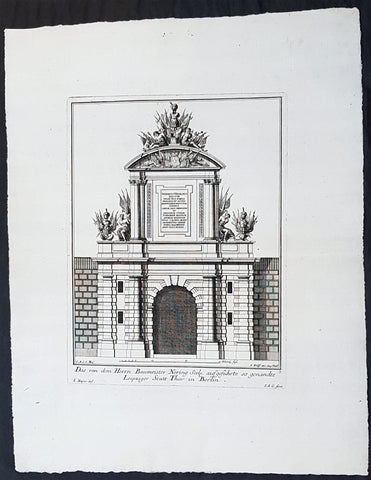
1740 Wolff & Corvinus Antique Architectural Print of Berlin Gate, Leipziger Tor
Antique Map
- Title : Das von dem Herrn Baumeister Nering Seel. ausgefuhrte so genandte Leipziger Statt Thor in Berlin
- Ref #: 93452
- Size: 19in x 12 1/2in (490mm x 335mm)
- Date : 1740
- Condition: (A+) Fine Condition
Description:
This large fine, original copper-plate engraved antique architectural print of buildings & gardens in 17th & 18th century Berlin - plate No. 3 of 16 - by Johann August Corvinus 1683 - 1738, after Andreas Mayers 1716 - 1782, was published in Eigentliche Abbildung des Prächtigen Königl. Lust Schlosses Charlottenburg, eine Meile von Berlin, sambt dem darhinden im Walde gelegenen schönen Lust Garten
(Set of 16 numbered plates, the first with the title, with plans and views of the buildings and gardens at Charlottenburg, the palace of the King of Prussia on the outskirts of Berlin.) by Jeremias Wolff Erben in 1740.
General Definitions:
Paper thickness and quality: - Heavy and stable
Paper color : - off white
Age of map color: -
Colors used: -
General color appearance: -
Paper size: - 19in x 12 1/2in (490mm x 335mm)
Plate size: - 14 1/2in x 10 1/2in (370mm x 260mm)
Margins: - Min 1in (25mm)
Imperfections:
Margins: - None
Plate area: - None
Verso: - None
Background:
Berlin straddles the banks of the River Spree, which flows into the River Havel (a tributary of the River Elbe) in the western borough of Spandau. Among the citys main topographical features are the many lakes in the western and southeastern boroughs formed by the Spree, Havel, and Dahme rivers (the largest of which is Lake Müggelsee). Due to its location in the European Plain, Berlin is influenced by a temperate seasonal climate. About one-third of the citys area is composed of forests, parks, gardens, rivers, canals and lakes. The city lies in the Central German dialect area, the Berlin dialect being a variant of the Lusatian-New Marchian dialects.
First documented in the 13th century and situated at the crossing of two important historic trade routes, Berlin became the capital of the Margraviate of Brandenburg (1417–1701), the Kingdom of Prussia (1701–1918), the German Empire (1871–1918), the Weimar Republic (1919–1933), and the Third Reich (1933–1945). Berlin in the 1920s was the third-largest municipality in the world. After World War II and its subsequent occupation by the victorious countries, the city was divided; West Berlin became a de facto West German exclave, surrounded by the Berlin Wall (1961–1989) and East German territory. East Berlin was declared capital of East Germany, while Bonn became the West German capital. Following German reunification in 1990, Berlin once again became the capital of all of Germany.
The Thirty Years War between 1618 and 1648 devastated Berlin. One third of its houses were damaged or destroyed, and the city lost half of its population. Frederick William, known as the Great Elector, who had succeeded his father George William as ruler in 1640, initiated a policy of promoting immigration and religious tolerance. With the Edict of Potsdam in 1685, Frederick William offered asylum to the French Huguenots.
By 1700, approximately 30 percent of Berlins residents were French, because of the Huguenot immigration. Many other immigrants came from Bohemia, Poland, and Salzburg.
Since 1618, the Margraviate of Brandenburg had been in personal union with the Duchy of Prussia. In 1701, the dual state formed the Kingdom of Prussia, as Frederick III, Elector of Brandenburg, crowned himself as king Frederick I in Prussia. Berlin became the capital of the new Kingdom, replacing Königsberg. This was a successful attempt to centralise the capital in the very far-flung state, and it was the first time the city began to grow. In 1709, Berlin merged with the four cities of Cölln, Friedrichswerder, Friedrichstadt and Dorotheenstadt under the name Berlin, Haupt- und Residenzstadt Berlin.
In 1740, Frederick II, known as Frederick the Great (1740–1786), came to power. Under the rule of Frederick II, Berlin became a center of the Enlightenment, but also, was briefly occupied during the Seven Years War by the Russian army. Following Frances victory in the War of the Fourth Coalition, Napoleon Bonaparte marched into Berlin in 1806, but granted self-government to the city. In 1815, the city became part of the new Province of Brandenburg.
The Industrial Revolution transformed Berlin during the 19th century; the citys economy and population expanded dramatically, and it became the main railway hub and economic centre of Germany. Additional suburbs soon developed and increased the area and population of Berlin. In 1861, neighbouring suburbs including Wedding, Moabit and several others were incorporated into Berlin. In 1871, Berlin became capital of the newly founded German Empire. In 1881, it became a city district separate from Brandenburg.
Wolff, Jeremais 1663 - 1724
Wolff was an German engraver and publisher. Born in Augsburg, he originally trained as a clock and automat maker, later changing course and opening a small copperplate engraving shop. His success was impressive and became one of the largest European art, print & map publishers in the first half of the 18th century. Wolff employed some of the best engravers of the time and although not an engraver himself, only Wolffs name was recorded on the engravings. Many of his engravers went uncredited for their work. In 1710 Wolff was one of the founder member of the Empire State Academy of Arts in Augsburg.
After his death in 1724, Wolffs publishing business was inherited by his sons and son-in-law, Johann Balthasar Probst (1673–1750) a notable engraver at the time. The firm continued on in Augsburg under the name Jeremias Wolff Erben.
Together with the Nuremberg copperplate engraver Paul Decker , Wolff published a series of engravings showing the war successes of Prince Eugene of Savoy in Italy , southern Germany and the Spanish Netherlands, during the War of the Spanish Succession . The prints are exhibited in the Museum of Military History, in Vienna .
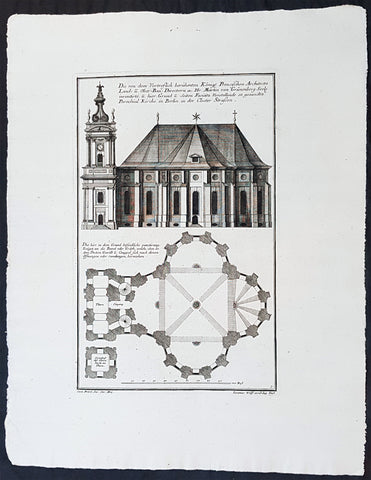
1740 Wolff & Corvinus Antique Architectural Print Parochialkirche, Mitte, Berlin
Antique Map
- Title : Die Von dem Vortreslich beruhmten Konigl. Preusichen Architect Land u. Ober Bau Directorn etc. Hr. Martin von Grunenberg Seel. inventirte, u. hier Grund u. Seiten Faciata Vorstellende so genandte Parochial Kirche in Berlin in der Closter Strassen
- Ref #: 93451
- Size: 19in x 12 1/2in (490mm x 335mm)
- Date : 1740
- Condition: (A+) Fine Condition
Description:
This large rare, original copper-plate engraved antique architectural print of the Parochialkirche (literally the Reformed parochial church) in the Mitte suburb of Berlin - plate No. 5 of 16 - by Johann August Corvinus 1683 - 1738, after Andreas Mayers 1716 - 1782, was published in Eigentliche Abbildung des Prächtigen Königl. Lust Schlosses Charlottenburg, eine Meile von Berlin, sambt dem darhinden im Walde gelegenen schönen Lust Garten
(Set of 16 numbered plates, the first with the title, with plans and views of the buildings and gardens at Charlottenburg, the palace of the King of Prussia on the outskirts of Berlin.) by Jeremias Wolff Erben in 1740.
General Definitions:
Paper thickness and quality: - Heavy and stable
Paper color : - off white
Age of map color: -
Colors used: -
General color appearance: -
Paper size: - 19in x 12 1/2in (490mm x 335mm)
Plate size: - 14 1/2in x 10 1/2in (370mm x 260mm)
Margins: - Min 1in (25mm)
Imperfections:
Margins: - None
Plate area: - None
Verso: - None
Background:
Berlin straddles the banks of the River Spree, which flows into the River Havel (a tributary of the River Elbe) in the western borough of Spandau. Among the citys main topographical features are the many lakes in the western and southeastern boroughs formed by the Spree, Havel, and Dahme rivers (the largest of which is Lake Müggelsee). Due to its location in the European Plain, Berlin is influenced by a temperate seasonal climate. About one-third of the citys area is composed of forests, parks, gardens, rivers, canals and lakes. The city lies in the Central German dialect area, the Berlin dialect being a variant of the Lusatian-New Marchian dialects.
First documented in the 13th century and situated at the crossing of two important historic trade routes, Berlin became the capital of the Margraviate of Brandenburg (1417–1701), the Kingdom of Prussia (1701–1918), the German Empire (1871–1918), the Weimar Republic (1919–1933), and the Third Reich (1933–1945). Berlin in the 1920s was the third-largest municipality in the world. After World War II and its subsequent occupation by the victorious countries, the city was divided; West Berlin became a de facto West German exclave, surrounded by the Berlin Wall (1961–1989) and East German territory. East Berlin was declared capital of East Germany, while Bonn became the West German capital. Following German reunification in 1990, Berlin once again became the capital of all of Germany.
The Thirty Years War between 1618 and 1648 devastated Berlin. One third of its houses were damaged or destroyed, and the city lost half of its population. Frederick William, known as the Great Elector, who had succeeded his father George William as ruler in 1640, initiated a policy of promoting immigration and religious tolerance. With the Edict of Potsdam in 1685, Frederick William offered asylum to the French Huguenots.
By 1700, approximately 30 percent of Berlins residents were French, because of the Huguenot immigration. Many other immigrants came from Bohemia, Poland, and Salzburg.
Since 1618, the Margraviate of Brandenburg had been in personal union with the Duchy of Prussia. In 1701, the dual state formed the Kingdom of Prussia, as Frederick III, Elector of Brandenburg, crowned himself as king Frederick I in Prussia. Berlin became the capital of the new Kingdom, replacing Königsberg. This was a successful attempt to centralise the capital in the very far-flung state, and it was the first time the city began to grow. In 1709, Berlin merged with the four cities of Cölln, Friedrichswerder, Friedrichstadt and Dorotheenstadt under the name Berlin, Haupt- und Residenzstadt Berlin.
In 1740, Frederick II, known as Frederick the Great (1740–1786), came to power. Under the rule of Frederick II, Berlin became a center of the Enlightenment, but also, was briefly occupied during the Seven Years War by the Russian army. Following Frances victory in the War of the Fourth Coalition, Napoleon Bonaparte marched into Berlin in 1806, but granted self-government to the city. In 1815, the city became part of the new Province of Brandenburg.
The Industrial Revolution transformed Berlin during the 19th century; the citys economy and population expanded dramatically, and it became the main railway hub and economic centre of Germany. Additional suburbs soon developed and increased the area and population of Berlin. In 1861, neighbouring suburbs including Wedding, Moabit and several others were incorporated into Berlin. In 1871, Berlin became capital of the newly founded German Empire. In 1881, it became a city district separate from Brandenburg.
Wolff, Jeremais 1663 - 1724
Wolff was an German engraver and publisher. Born in Augsburg, he originally trained as a clock and automat maker, later changing course and opening a small copperplate engraving shop. His success was impressive and became one of the largest European art, print & map publishers in the first half of the 18th century. Wolff employed some of the best engravers of the time and although not an engraver himself, only Wolffs name was recorded on the engravings. Many of his engravers went uncredited for their work. In 1710 Wolff was one of the founder member of the Empire State Academy of Arts in Augsburg.
After his death in 1724, Wolffs publishing business was inherited by his sons and son-in-law, Johann Balthasar Probst (1673–1750) a notable engraver at the time. The firm continued on in Augsburg under the name Jeremias Wolff Erben.
Together with the Nuremberg copperplate engraver Paul Decker , Wolff published a series of engravings showing the war successes of Prince Eugene of Savoy in Italy , southern Germany and the Spanish Netherlands, during the War of the Spanish Succession . The prints are exhibited in the Museum of Military History, in Vienna .
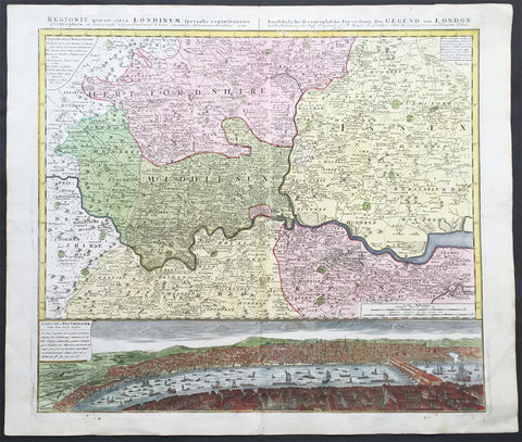
1741 Large Homann Antique Map of London Surrey - Birds Eye View of London
- Title : Regionis quae est circa Londinum....Homaniamus Heredibus 1741
- Date : 1741
- Condition: (A+) Fine Condition
- Ref: 92275
- Size: 25 ½in x 21 ½in (650mm x 550mm)
Description:
This beautifully hand coloured original antique map* of the Environs of London - Middlesex, Essex, Surrey and Kent - with a beautiful and a very real view of the city of London in the mid 18th century and the Thames - was engraved in 1741 - dated at the top of the map - and was published by the Homann firm.
A superb map with a deep heavy impression, stunning colour and sound heavy paper, a fine map.
Background: This map is based upon an earlier map of the region by Thomas Bowles and covers the London area from Berkshire (including Windsor Castle) in the west to Shamel in the east, extending north north as far as Bedford. Specifically focuses on Hertfordshire, Middlesex, Surrey, Essex and Kent. Offers extraordinary detail throughout, showing roadways, villages, London Streets, estates, and in many cases, individual homes. The lower portion of the sheet is dominated by a dramatic bird's-eye view of London and Westminster from Southwark across the Thames. View reveals a densely populated showing numerous boats, barges, and sailing vessels.
The beautifully hand coloured view of the city of London & Westminster was published only 90 odd years after the great fire of 1666.The view of London after Thomas Bowles, was one of a number published by Bowles and the Homann firm in the mid 18th century illustrating the growth and change of the great city.
The view is stunning, stretching from old London bridge & the docklands in the east to the farmlands to the west. What is really fascinating is the level of detail. There are a myriad of different sailing vessels occupying both sides of London bridge. The number of shops and residences that occupied the bridge at that time are uniquely displayed as is the number churches and cathedrals that dominate the skyline. To the right you can see the farm land that will one day become the West End and other upmarket areas of London.(Ref: M&B; Tooley)
General Description:
Paper thickness and quality: - Heavy and stable
Paper color: - off white
Age of map color: - Original & later color
Colors used: - Yellow, green, pink
General color appearance: - Authentic
Paper size: - 25 ½in x 21 ½in (650mm x 550mm)
Plate size: - 22 ½in x 20in (570mm x 510mm)
Margins: - Min ½in (12mm)
Imperfections:
Margins: - Light soiling in margins
Plate area: - None
Verso: - Bottom left plate-mark a little worn
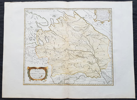
1741 Nicolas Sanson Large Antique Map of Sarmatia, Modern Day Russia & Ukraine
- Title : Sarmatia Utraque Europaea et Asiatica Autore Nicolas Sanson...1741
- Ref #: 50602
- Size: 27in x 20 1/4in (690mm x 515mm)
- Date : 1741
- Condition: (A+) Fine Condition
Description:
This fine original hand coloured copper-plate engraved antique map of the land of the Sarmatians - today stretching encompassing modern day European Russia and Ukraine and central Asia by Nicolas Sanson, was engraved in 1741 - dated in the cartouche - and was published by Robert De Vaugondy in a re-issue of Sansons atlas Cartes Generales de Toutes les Parties du Monde
General Definitions:
Paper thickness and quality: - Heavy and stable
Paper color : - off white
Age of map color: - Original & later
Colors used: - Yellow, green, blue, pink
General color appearance: - Authentic
Paper size: - 27in x 20 1/4in (690mm x 515mm)
Plate size: - 19in x 16 1/2in (485mm x 420mm)
Margins: - Min 2in (50mm)
Imperfections:
Margins: - None
Plate area: - None
Verso: - None
Background:
The Sarmatians were a large Iranian confederation that existed in classical antiquity, flourishing from about the 5th century BC to the 4th century AD.
Originating in the central parts of the Eurasian Steppe, the Sarmatians started migrating westward around the 4th and 3rd centuries BC, coming to dominate the closely related Scythians by 200 BC. At their greatest reported extent, around 1st century AD, these tribes ranged from the Vistula River to the mouth of the Danube and eastward to the Volga, bordering the shores of the Black and Caspian seas as well as the Caucasus to the south. Their territory, which was known as Sarmatia to Greco-Roman ethnographers, corresponded to the western part of greater Scythia (it included todays Central Ukraine, South-Eastern Ukraine, Southern Russia, Russian Volga and South-Ural regions, also to a smaller extent north-eastern Balkans and around Moldova). In the 1st century AD, the Sarmatians began encroaching upon the Roman Empire in alliance with Germanic tribes. In the 3rd century AD, their dominance of the Pontic Steppe was broken by the Germanic Goths. With the Hunnic invasions of the 4th century, many Sarmatians joined the Goths and other Germanic tribes (Vandals) in the settlement of the Western Roman Empire. Since large parts of todays Russia, actually the land between the Ural Mountains and the Don River, were controlled in the 5th century BC by the Sarmatians, Volga–Don and Ural steppes sometimes are also called Sarmatian Motherland.
The Sarmatians were eventually decisively assimilated (e.g. Slavicisation) and absorbed by the Proto-Slavic population of Eastern Europe.
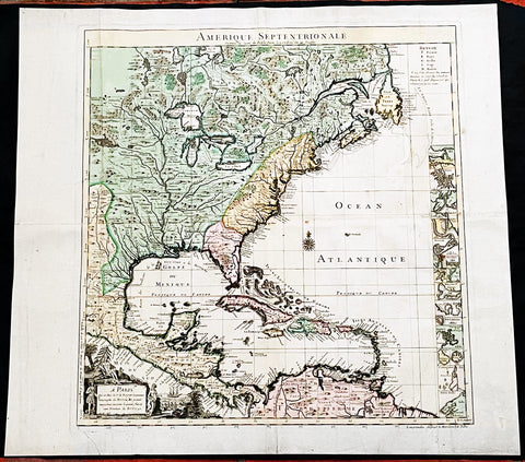
1742 Henry Popple & George Le Rouge Large Antique Map of Colonial America
Antique Map
- Title : Amerique Septentrionale Suivant la Carte de Pople....A Paris....Le Rouge...1742
- Date : 16742
- Size: 24 1/2in x 22 1/2in (625mm x 570mm)
- Condition: (A) Very Good Condition
- Ref: 27093
Description:
This incredibly important, original hand coloured copper plate engraved antique map of North America by George Le Rouge, after Henry Popples famous North America map, was published in 1742 - dated.
A handsome key sheet from a French edition of the first large-scale map of colonial North America. Among the 18 inset maps along the right border are ones of Bermuda, Boston, New York City, and Charleston. Popple's original, 1733 map ran to 20 sheets, hence the necessity of a key sheet. It was a semi-official undertaking intended to depict for British colonial administrators the respective North American territories of England, France and Spain. This French-published version, as expected, greatly exaggerates French territory at the expense of both England and Spain.
General Definitions:
Paper thickness and quality: - Heavy and stable
Paper color : - off white
Age of map color: - Original & later
Colors used: - Yellow, green, blue, pink
General color appearance: - Authentic
Paper size: - 24 1/2in x 22 1/2in (625mm x 570mm)
Plate size: - 20 3/4in x 19 3/4in (525mm x 500mm)
Margins: - Min 1in (30mm)
Imperfections:
Margins: - Light creasing along margins
Plate area: - Light creasing
Verso: - Re-enforced along centerfold
Background:
In 1730, the English Board of Trade & Plantations issued a request for maps of the British, French, and Spanish territorial claims in the New World, as ongoing boundary conflicts hindered economic development in the colonies. A former employee, Henry Popple, created an incredible 20-sheet map first published in 1733 that covered a broad region between Hudson Bay and the northern coast of South America and inland as far as the Rio Grande. It would become tremendously influential diplomatically as disputes among European powers increased dramatically in subsequent decades.
Accompanying the monumental production was a keymap, seen here as a later French edition issued by Georges Louis Le Rouge in 1742. With the exception of the language, decorative elements, annotations, and a missing vignette in the upper left corner, the image is largely the same as the original. It’s surprisingly accurate, as Popple was studious in his use of the latest available sources, though several geographic features have been enlarged or distorted and a large mysterious lake filled with islands appears near the western edge of the sheet.
It’s likely this is a remnant of the great saline sea speculated by Baron Lahontan, a French military officer who traveled extensively throughout the Great Lakes region from 1684 -1689. He later wrote several popular travel volumes that included reports of a Long (or Longue) River that branched from the Missippi westward, eventually reaching a large salt lake at the foot of a mountain range. The geographic influences of his story would be reflected in subsequent cartographic efforts throughout the 18th and into the early 19th century, and speculation on Lahontan’s travels persists to this day.
Elsewhere in the image, the topography is depicted pictorially and shows a prominent Appalachian Mountain range as well as a curious plateau in Michigan that Lewis Karpinski describes as a “fanciful creation.” Native American and European settlements are identified throughout and geographic features are labeled according to the key in the upper right. Seventeen inset plans of prominent port cities and islands can be seen in the lower right; including Boston, Charleston, New York, St. Augustine, Havana, and Cartagena.
Popple, Henry 1680 - 1743
Henry Popple was a British cartographer active in the early part of the 18th century. Popple was a clerk with the Board of Trade and Plantations, the organization that governed Britain's colonies in America. With his father, grandfather, and brother all being employed the board of trade, the Popple family had a long history of association with the British colonial administration. Popple received his commission as a clerk at the board of trade in 1727, but resigned in the same year. Curiously this is the same year he began work on his signature production, the Popple of North America, he resigned from the board to take a position as the Cashier to Queen Anne. Nonetheless he continued to work on his great maps and a manuscript version of the Popple Map appeared in this very year. Subsequently, Popple continued to update and refine the map until 1733 when it was finally printed. The Board of trade intended the Popple map to be a British response to Delisle's French mapping of North America, which presented boundaries that conflicted with British colonial ambitions. However, since Popple in fact based much of his map on Delisle's superior cartography, he also managed to copy many of the French political boundaries - to the detriment of the Board of Trade and its expansionist intentions. Although Popple's map was never approved by the Board, examples were rushed to each colonial governor and the map played a significant role in the cartographic history of North America. Popple cartographic endeavor began and ended with this singular map however, it significance was such that he must be considered in any list of significant British mapmakers.
George Louis Le Rouge fl. 1740-80
A military engineer by profession, le Rouge took up cartography and over a long period from about 1740 to 1780 produced many attractive works covering a wide range of subjects including plans of fortifications, military campaigns, town plans as well as the more usual atlases and sea charts.
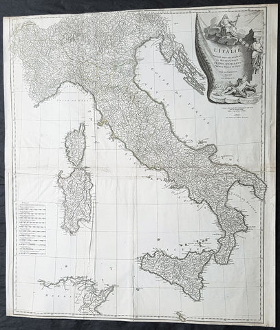
1743 D Anville & CA Coypel Large Antique Map of Italy, Sicily, Sardinia, Corsica
- Title : L Italie Publiee Sous Les Auspices De Monseigneur Le Duc D Orleans, Premier Prince Du Sang....Par L Sr D Anville...MDCCXLIII
- Date : 1743
- Condition: (A) Very Good Condition
- Ref: 92312
- Size: 32in x 28in (820mm x 710mm)
Description:
This large scarce original copper-plate engraved antique map of contemporary Italy, Sicily, Sardinia, Corsica & Malta by Charles-Antoine Coypel was engraved by Pierre-Alexandre Aveline (1702–1760) (both names engraved under cartouche) in 1743 - dated in cartouche - and was published by Jean-Baptiste Bourguinon D Anvilles in his large elephant folio atlas Atlas Generale.
A scarce and hard to find map with two famous names Charles-Antoine Coypel & Pierre-Alexandre Aveline engraved below the cartouche, I am assuming as both drawer & engraver.
General Definitions:
Paper thickness and quality: - Heavy and stable
Paper color : - off white
Age of map color: -
Colors used: -
General color appearance: -
Paper size: - 32in x 28in (820mm x 710mm)
Plate size: - 31 1/2in x 27in (810mm x 690mm)
Margins: - Min 1/8in (2mm)
Imperfections:
Margins: - Top margin cropped to border
Plate area: - Light creasing
Verso: - Creasing
Background:
Since classical times the countries bordering the enclosed waters of the Mediterranean had been well versed in the use of maps and sea charts and in Italy, more than anywhere else, the traditional knowledge was kept alive during the many hundreds of years following the collapse of the Roman Empire. By the thirteenth and fourteenth centuries the seamen of Venice, Genoa and Amalfi traded to far countries, from the Black Sea ports and the coasts of Palestine and Egypt in the East to Flanders and the southern coasts of England and Ireland in the West, their voyages guided by portulan charts and the use of the newly invented compass. For a time Italian supremacy in cartography passed to Aragon and the Catalan map makers based on Majorca, but by the year 1400 the power and wealth of the city states of Venice, Genoa, Florence and Milan surpassed any in Europe. Florence, especially, under the rule of the Medici family, became not only a great trading and financial centre but also the focal point of the rediscovery of the arts and learning of the ancient world. In this milieu a number of manuscript world maps were produced, of which one by Fra Mauro (c. 1459) is the most notable, but the event of the greatest importance in the history of cartography occurred in the year 1400 when a Florentine, Palla Strozzi, brought from Constantinople a Greek manuscript copy of Claudius Ptolemy\\\'s Geographia, which, 1,250 years after its compilation, came as a revelation to scholars in Western Europe. In the following fifty years or so manuscript copies, translated into Latin and other languages, became available in limited numbers but the invention of movable-type printing transformed the scene: the first copy without maps being printed in 1475 followed by many with copper-engraved maps, at Bologna in 1477, Rome 1478, 1490, 1507 and 1508, and Florence 1482.
About the year 1485 the first book of sea charts, compiled by Bartolommeo dalli Sonetti, was printed in Venice and in the first part of the sixteenth century a number of world maps were published, among them one compiled in 1506 by Giovanni Contarini, engraved by Francesco Rosselli, which was the first printed map to show the discoveries in the New World. In the following years there were many attractive and unusual maps of Islands (Isolano) by Bordone, Camocio and Porcacchi, but more important was the work of Giacomo (Jacopo) Gastaldi, a native of Piedmont who started life as an engineer in the service of the Venetian Republic before turning to cartography as a profession. His maps, produced in great variety and quantity, were beautifully drawn copperplate engravings and his style and techniques were widely copied by his contemporaries. From about 1550 to 1580 many of Gastaldi\\\'s maps appeared in the collections of maps known as Lafreri \\\'atlases\\\', a term applied to groups of maps by different cartographers brought together in one binding. As the contents of such collections varied considerably they were no doubt assembled at the special request of wealthy patrons and are now very rare indeed.
About this time, for a variety of historical and commercial reasons, Italy\\\'s position as the leading trading and financial nation rapidly declined and with it her superiority in cartography was lost to the vigorous new states in the Low Countries. That is not to say, of course, that Italian skills as map makers were lost entirely for it was not until 1620 that the first printed maps of Italy by an Italian, Giovanni Magini, appeared, and much later in the century there were fine maps by Giacomo de Rossi and Vincenzo Coronelli, the latter leading a revival of interest in cartography at the end of the century. Coronelli was also famous for the construction of magnificent large-size globes and for the foundation in Venice in 1680 of the first geographical society.
In the eighteenth century the best-known names are Antonio Zatta, Rizzi-Zannoni and Giovanni Cassini.
We ought to mention the work of Baptista Boazio who drew a series of maps in A Summarie and True Discourse of Sir Francis Drake\\\'s West Indian Voyage, published in 1588-89, and who is especially noted for a very fine map of Ireland printed in 1599 which was incorporated in the later editions of the Ortelius atlases. It is perhaps appropriate also to refer to two English map makers who spent many years in exile in Italy: the first, George Lily, famous for the splendid map of the British Isles issued in Rome in 1546, and the second, Robert Dudley, who exactly one hundred years later was responsible for the finest sea atlas of the day, Dell\\\' Arcano del Mare, published in Florence. Both of these are described in greater detail elsewhere in this handbook. (Ref: Tooley, Koeman)
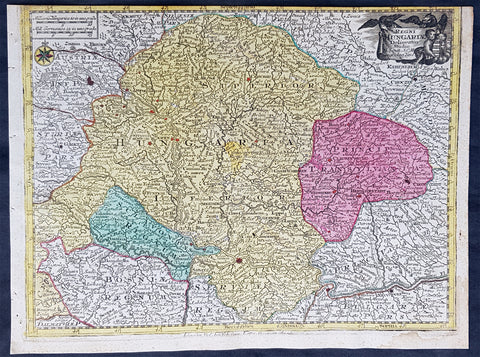
1744 Georg Mattaus Seutter Antique Map Hungarian Empire, Transylvania, Sclavonia
Antique Map
- Title : Regni Hungariae........a Matth. Seutteri...T C Lotter, Geogr.
- Ref #: 93399
- Size: 11in x 8 1/2in (280mm x 215mm)
- Date : 1744
- Condition: (A) Very Good Condition
Description:
This beautifully hand coloured original copper-plate engraved antique map of the Hungarian Empire was engraved by Tobias Lotter and was published in the 1744 edition of GM Seutters Atlas Minor Prae cipua Orbis Terrarum Imperia Regna et Provincias...., Augsburg, Germany.
General Definitions:
Paper thickness and quality: - Heavy and stable
Paper color : - off white
Age of map color: - Original
Colors used: - Yellow, green, blue, pink
General color appearance: - Authentic
Paper size: - 11in x 8 1/2in (280mm x 215mm)
Plate size: - 10 1/2in x 8in (265mm x 205mm)
Margins: - Min 1/4in (5mm)
Imperfections:
Margins: - Top margin cropped into border
Plate area: - None
Verso: - None
Background:
Atlas Minor was a series of beautiful maps of all parts of the world. Georg Matthäus Seutter was one of the most and important of the German cartographers of the 18th century, being appointed as the Geographer to the Imperial Court. His son, Albrecht Carl, joined Matthäus and eventually inherited the business. The maps from Atlas Minor were drawn by the two Seutters and engraved by Tobias Conrad Lotte. These maps are highly detailed and engraved with a bold hand with equally strong original hand color in the body of the map as was the 18th century German style. The cartouches were left uncolored in order to emphasize the elaborately detailed illustrations for which German maps are especially prized. These are some of the most decorative and interesting maps of the eighteenth century.
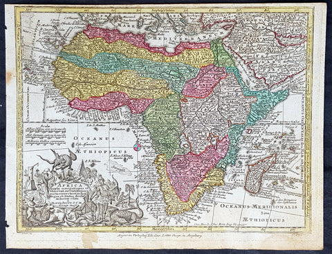
1744 Georg Mattaus Seutter Antique Map of Africa
Antique Map
- Title : Africa a Matth. Seutteri...T C Lotter, Geogr.
- Ref #: 93390
- Size: 11in x 8 1/2in (280mm x 215mm)
- Date : 1744
- Condition: (A+) Fine Condition
Description:
These beautifully hand coloured original copper-plate engraved antique map was engraved by Tobias Lotter and published in the 1744 edition of GM Seutters Atlas Minor Prae cipua Orbis Terrarum Imperia Regna et Provincias...., Augsburg, Germany.
General Definitions:
Paper thickness and quality: - Heavy and stable
Paper color : - off white
Age of map color: - Early
Colors used: - Yellow, green, blue, pink
General color appearance: - Authentic
Paper size: - 11in x 8 1/2in (280mm x 215mm)
Plate size: - 10 1/2in x 8in (265mm x 205mm)
Margins: - Min 1/4in (5mm)
Imperfections:
Margins: - Age toning to margins
Plate area: - None
Verso: - None
Background:
Atlas Minor was a series of beautiful maps of all parts of the world. Georg Matthäus Seutter was one of the most and important of the German cartographers of the 18th century, being appointed as the Geographer to the Imperial Court. His son, Albrecht Carl, joined Matthäus and eventually inherited the business. The maps from Atlas Minor were drawn by the two Seutters and engraved by Tobias Conrad Lotte. These maps are highly detailed and engraved with a bold hand with equally strong original hand color in the body of the map as was the 18th century German style. The cartouches were left uncolored in order to emphasize the elaborately detailed illustrations for which German maps are especially prized. These are some of the most decorative and interesting maps of the eighteenth century.
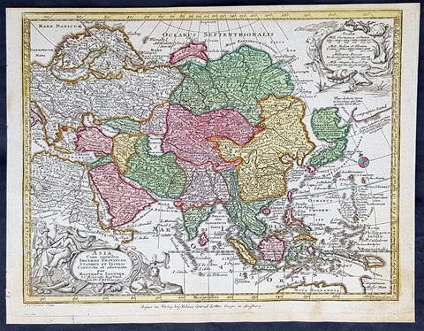
1744 Georg Mattaus Seutter Antique Map of Asia
Antique Map
- Title : Asia a Matth. Seutteri...T C Lotter, Geogr.
- Ref #: 93389
- Size: 11in x 8 1/2in (280mm x 215mm)
- Date : 1744
- Condition: (A+) Fine Condition
Description:
These beautifully hand coloured original copper-plate engraved antique map was engraved by Tobias Lotter and published in the 1744 edition of GM Seutters Atlas Minor Prae cipua Orbis Terrarum Imperia Regna et Provincias...., Augsburg, Germany.
General Definitions:
Paper thickness and quality: - Heavy and stable
Paper color : - off white
Age of map color: - Early
Colors used: - Yellow, green, blue, pink
General color appearance: - Authentic
Paper size: - 11in x 8 1/2in (280mm x 215mm)
Plate size: - 10 1/2in x 8in (265mm x 205mm)
Margins: - Min 1/4in (5mm)
Imperfections:
Margins: - None
Plate area: - None
Verso: - None
Background:
Atlas Minor was a series of beautiful maps of all parts of the world. Georg Matthäus Seutter was one of the most and important of the German cartographers of the 18th century, being appointed as the Geographer to the Imperial Court. His son, Albrecht Carl, joined Matthäus and eventually inherited the business. The maps from Atlas Minor were drawn by the two Seutters and engraved by Tobias Conrad Lotte. These maps are highly detailed and engraved with a bold hand with equally strong original hand color in the body of the map as was the 18th century German style. The cartouches were left uncolored in order to emphasize the elaborately detailed illustrations for which German maps are especially prized. These are some of the most decorative and interesting maps of the eighteenth century.
1744 Georg Mattaus Seutter Antique Map of Europe
Antique Map
- Title : Europa a Matth. Seutteri...T C Lotter, Geogr.
- Ref #: 93388
- Size: 11in x 8 1/2in (280mm x 215mm)
- Date : 1744
- Condition: (A+) Fine Condition
Description:
These beautifully hand coloured original copper-plate engraved antique map was engraved by Tobias Lotter and published in the 1744 edition of GM Seutters Atlas Minor Prae cipua Orbis Terrarum Imperia Regna et Provincias...., Augsburg, Germany.
General Definitions:
Paper thickness and quality: - Heavy and stable
Paper color : - off white
Age of map color: - Early
Colors used: - Yellow, green, blue, pink
General color appearance: - Authentic
Paper size: - 11in x 8 1/2in (280mm x 215mm)
Plate size: - 10 1/2in x 8in (265mm x 205mm)
Margins: - Min 1/4in (5mm)
Imperfections:
Margins: - None
Plate area: - None
Verso: - None
Background:
Atlas Minor was a series of beautiful maps of all parts of the world. Georg Matthäus Seutter was one of the most and important of the German cartographers of the 18th century, being appointed as the Geographer to the Imperial Court. His son, Albrecht Carl, joined Matthäus and eventually inherited the business. The maps from Atlas Minor were drawn by the two Seutters and engraved by Tobias Conrad Lotte. These maps are highly detailed and engraved with a bold hand with equally strong original hand color in the body of the map as was the 18th century German style. The cartouches were left uncolored in order to emphasize the elaborately detailed illustrations for which German maps are especially prized. These are some of the most decorative and interesting maps of the eighteenth century.
1744 Georg Mattaus Seutter Antique Map of France
Antique Map
- Title : Gallia....a Matth. Seuttero...T C Lotter, Geogr.
- Ref #: 93393
- Size: 11in x 8 1/2in (280mm x 215mm)
- Date : 1744
- Condition: (A+) Fine Condition
Description:
This beautifully hand coloured original copper-plate engraved antique map of France was engraved by Tobias Lotter and was published in the 1744 edition of GM Seutters Atlas Minor Prae cipua Orbis Terrarum Imperia Regna et Provincias...., Augsburg, Germany.
General Definitions:
Paper thickness and quality: - Heavy and stable
Paper color : - off white
Age of map color: - Original
Colors used: - Yellow, green, blue, pink
General color appearance: - Authentic
Paper size: - 11in x 8 1/2in (280mm x 215mm)
Plate size: - 10 1/2in x 8in (265mm x 205mm)
Margins: - Min 1/4in (5mm)
Imperfections:
Margins: - Light age toning
Plate area: - Light age toning
Verso: - None
Background:
Atlas Minor was a series of beautiful maps of all parts of the world. Georg Matthäus Seutter was one of the most and important of the German cartographers of the 18th century, being appointed as the Geographer to the Imperial Court. His son, Albrecht Carl, joined Matthäus and eventually inherited the business. The maps from Atlas Minor were drawn by the two Seutters and engraved by Tobias Conrad Lotte. These maps are highly detailed and engraved with a bold hand with equally strong original hand color in the body of the map as was the 18th century German style. The cartouches were left uncolored in order to emphasize the elaborately detailed illustrations for which German maps are especially prized. These are some of the most decorative and interesting maps of the eighteenth century.
1744 Georg Mattaus Seutter Antique Map of Germany w/ European City Mileage Chart
Antique Map
- Title : Germaniae Aliorumque Quorundam Locorum Europae Poliometria....Cart von Deutsschland...Tob. Conrad Lotter Geogr.
- Ref #: 93404
- Size: 11in x 8 1/2in (280mm x 215mm)
- Date : 1744
- Condition: (A+) Fine Condition
Description:
This beautifully hand coloured original copper-plate engraved antique map of Germany, with a mileage index chart with all the major cities of Europe, was engraved by Tobias Lotter and was published in the 1744 edition of GM Seutters Atlas Minor Prae cipua Orbis Terrarum Imperia Regna et Provincias...., Augsburg, Germany.
General Definitions:
Paper thickness and quality: - Heavy and stable
Paper color : - off white
Age of map color: - Original
Colors used: - Yellow, green, blue, pink
General color appearance: - Authentic
Paper size: - 11in x 8 1/2in (280mm x 215mm)
Plate size: - 10 1/2in x 8in (265mm x 205mm)
Margins: - Min 1/4in (5mm)
Imperfections:
Margins: - Light age toning
Plate area: - Light age toning
Verso: - None
Background:
Atlas Minor was a series of beautiful maps of all parts of the world. Georg Matthäus Seutter was one of the most and important of the German cartographers of the 18th century, being appointed as the Geographer to the Imperial Court. His son, Albrecht Carl, joined Matthäus and eventually inherited the business. The maps from Atlas Minor were drawn by the two Seutters and engraved by Tobias Conrad Lotte. These maps are highly detailed and engraved with a bold hand with equally strong original hand color in the body of the map as was the 18th century German style. The cartouches were left uncolored in order to emphasize the elaborately detailed illustrations for which German maps are especially prized. These are some of the most decorative and interesting maps of the eighteenth century.

1744 Georg Mattaus Seutter Antique Map of Germany, Central & NW Europe
Antique Map
- Title : Imperium Romano Germanicum........a Matth. Seutteri...T C Lotter, Geogr.
- Ref #: 93398
- Size: 11in x 8 1/2in (280mm x 215mm)
- Date : 1744
- Condition: (A+) Fine Condition
Description:
This beautifully hand coloured original copper-plate engraved antique map of Germany and NW Europe was engraved by Tobias Lotter and was published in the 1744 edition of GM Seutters Atlas Minor Prae cipua Orbis Terrarum Imperia Regna et Provincias...., Augsburg, Germany.
General Definitions:
Paper thickness and quality: - Heavy and stable
Paper color : - off white
Age of map color: - Original
Colors used: - Yellow, green, blue, pink
General color appearance: - Authentic
Paper size: - 11in x 8 1/2in (280mm x 215mm)
Plate size: - 10 1/2in x 8in (265mm x 205mm)
Margins: - Min 1/4in (5mm)
Imperfections:
Margins: - Light age toning
Plate area: - Light age toning
Verso: - None
Background:
Atlas Minor was a series of beautiful maps of all parts of the world. Georg Matthäus Seutter was one of the most and important of the German cartographers of the 18th century, being appointed as the Geographer to the Imperial Court. His son, Albrecht Carl, joined Matthäus and eventually inherited the business. The maps from Atlas Minor were drawn by the two Seutters and engraved by Tobias Conrad Lotte. These maps are highly detailed and engraved with a bold hand with equally strong original hand color in the body of the map as was the 18th century German style. The cartouches were left uncolored in order to emphasize the elaborately detailed illustrations for which German maps are especially prized. These are some of the most decorative and interesting maps of the eighteenth century.
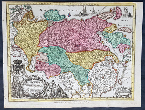
1744 Georg Mattaus Seutter Antique Map of The Russian Empire, China, Japan
- Title : Imperium Russiae Magnae........a Matth. Seutteri...T C Lotter, Geogr.
- Ref #: 93401
- Size: 11in x 8 1/2in (280mm x 215mm)
- Date : 1744
- Condition: (A+) Fine Condition
Description:
This beautifully hand coloured original copper-plate engraved antique map of The Russian Empire was engraved by Tobias Lotter and was published in the 1744 edition of GM Seutters Atlas Minor Prae cipua Orbis Terrarum Imperia Regna et Provincias...., Augsburg, Germany.
General Definitions:
Paper thickness and quality: - Heavy and stable
Paper color : - off white
Age of map color: - Original
Colors used: - Yellow, green, blue, pink
General color appearance: - Authentic
Paper size: - 11in x 8 1/2in (280mm x 215mm)
Plate size: - 10 1/2in x 8in (265mm x 205mm)
Margins: - Min 1/4in (5mm)
Imperfections:
Margins: - None
Plate area: - None
Verso: - None
Background:
Atlas Minor was a series of beautiful maps of all parts of the world. Georg Matthäus Seutter was one of the most and important of the German cartographers of the 18th century, being appointed as the Geographer to the Imperial Court. His son, Albrecht Carl, joined Matthäus and eventually inherited the business. The maps from Atlas Minor were drawn by the two Seutters and engraved by Tobias Conrad Lotte. These maps are highly detailed and engraved with a bold hand with equally strong original hand color in the body of the map as was the 18th century German style. The cartouches were left uncolored in order to emphasize the elaborately detailed illustrations for which German maps are especially prized. These are some of the most decorative and interesting maps of the eighteenth century.

1744 Nicolas Bellin Large Important Antique Map of North America, Charlevoix
- Title : Carte De La Louisiane Cours Du Mississipi et Pais Voisions Dediee a M la Comte de Maurepas...Par N Bellin Ingenieur de la Marine, 1744
- Date : 1744
- Condition: (A+) Fine Condition
- Ref: 93108
- Size: 29in x 20in (735mm x 515mm)
Description:
This large original hand coloured copper-plate engraved antique map of North America by Nicolas Bellin, in 1744 - dated - was engraved by Guillaume Dheulland (1700-1770) & published in Pierre Francois Xavier Charlevoix book on Canada & North America Histoire et Description Generale de la Nouvelle France avec Le Journal Historique d\'un Voyage fait par Ordre du Roi dans L\'Amérique Septentrionnale
Extremely important, large and much overlooked map of North America, extending from New England, The Great Lakes to Florida and west to the Rio Grande River, New Mexico, east to Santa Fe, Taos, and the known regions of the Missouri Valley. Charlevoix map provides a remarkable overview of the regions of the future United, in the first half of the 18th Century.
The map tracks to the sources of the Mississippi River and depicts 4 of the 5 Great providing the most up to date information on the Mississippi River Basin, Ohio River and the major river systems between the Mississippi River and the Appalachians.
The map is one of Bellins earliest of North America and was published map the regions described in Charlevoix Histoire et description générale de la Nouvelle France and was also compiled in part from the Chaussegros de Lery manuscripts. The map is noteworthy for the mountain range in Michigan that did not exist, with detailed text on American Indian locations and lands and notes on French forts and other early settlements and towns.
In 1720 the Duke of Orleans sent the Jesuit scholar and explorer Pierre François-Xavier de Charlevoix to America to record events in New France and Louisiana and determine the best route to the Pacific Ocean. Charlevoix gathered geographic information from fur traders in Quebec and travelled through the Great Lakes and down the Mississippi River. After he returned to France, Charlevoix published his views on North America, which has become one of the most important works on North America prior to the French & Indian, 7 years, war.
It is recorded that Thomas Jefferson owned a copy of Charlevoix book and recommended it, along with the accounts of Hennepin and Lahontan, as a particularly useful for detail in the largely unexplored regions of North America. He referred to Charlevoix book & Bellins map as he developed his own ideas of Louisiana and the Northwest.
General Definitions:
Paper thickness and quality: - Heavy and stable
Paper color : - off white
Age of map color: -
Colors used: -
General color appearance: -
Paper size: - 29in x 20in (735mm x 515mm)
Plate size: - 23in x 16 1/2in (590mm x 420mm)
Margins: - Min 1in (25mm)
Imperfections:
Margins: - Light soiling
Plate area: - None
Verso: - Light soiling
Background:
Pierre-François-Xavier de Charlevoix 1682 - 1761 was a French Jesuit priest who wrote one of the earliest descriptive accounts of North America.
Sent from France on a scientific and exploratory mission to Canada, where he had previously stayed, he traveled up the St. Lawrence River in 1720, passed through the Great Lakes, made the portage to the Mississippi River, survived shipwreck in the Gulf of Mexico, and visited the island of Santo Domingo. Returning home, he wrote Histoire de Saint-Domingue and Histoire et description générale de la Nouvelle-France the latter of much historical value.

1744 Nicolas Bellin Original Antique Map of Hudsons Bay & Surrounds, Canada
- Title : Karte Von Der Hudsons Bay Durch N Bellin..1744
- Ref #: 41156
- Size: 14in x 9 1/2in (355mm x 240mm)
- Date : 1744
- Condition: (A+) Fine Condition
Description:
This fine, original copper-plate engraved antique map of Hudsons Bay, Canada by Jacques Nicolas Bellin in 1744 was published in Antoine François Prevosts 15 volumes of Histoire Generale des Voyages written by Prevost & other authors between 1746-1790.
Hudson Bay is a large body of saltwater in northeastern Canada with a surface area of 1,230,000 km2 (470,000 sq mi). It drains a very large area, about 3,861,400 km2 (1,490,900 sq mi), that includes parts of southeastern Nunavut, Saskatchewan, Alberta, most of Manitoba, Ontario, Quebec and parts of North Dakota, South Dakota, Minnesota, and Montana. Hudson Bay\'s southern arm is called James Bay.
English explorers and colonists named Hudson Bay after Sir Henry Hudson who explored the bay beginning August 2, 1610 on his ship Discovery.:170 On his fourth voyage to North America, Hudson worked his way around Greenland\'s west coast and into the bay, mapping much of its eastern coast. Discovery became trapped in the ice over the winter, and the crew survived onshore at the southern tip of James Bay. When the ice cleared in the spring, Hudson wanted to explore the rest of the area, but the crew mutinied on June 22, 1611. They left Hudson and others adrift in a small boat. No one knows the fate of Hudson or the crew members stranded with him, but historians see no evidence that they survived for long afterwards.
In 1668, Nonsuch reached the bay and traded for beaver pelts, leading to the creation of the Hudson\'s Bay Company (HBC) which still bears the historic name. The HBC negotiated a trading monopoly from the English crown for the Hudson Bay watershed, called Rupert\'s Land. France contested this grant by sending several military expeditions to the region, but abandoned its claim in the Treaty of Utrecht (April 1713).
During this period, the Hudson\'s Bay Company built several factories (forts and trading posts) along the coast at the mouth of the major rivers (such as Fort Severn, Ontario; York Factory and Churchill, Manitoba). The strategic locations were bases for inland exploration. More importantly, they were trading posts with the indigenous peoples who came to them with furs from their trapping season. The HBC shipped the furs to Europe and continued to use some of these posts well into the 20th century.
General Definitions:
Paper thickness and quality: - Heavy and stable
Paper color : - off white
Age of map color: -
Colors used: -
General color appearance: -
Paper size: - 14in x 9 1/2in (355mm x 240mm)
Plate size: - 12in x 9in (305mm x 230mm)
Margins: - Min 1/2in (12mm)
Imperfections:
Margins: - None
Plate area: - Folds as issued
Verso: - None
Background:
One of Antoine Francois Prevosts monumental undertakings was his history of exploration & discovery in 15 volumes titledHistoire Générale des Voyages written between 1746-1759 and was extended to 20 volumes after his death by various authors.
The 20 volumes cover the early explorations & discoveries on 3 continents: Africa (v. 1-5), Asia (v. 5-11), and America (v. 12-15) with material on the finding of the French, English, Dutch, and Portugese.
A number of notable cartographers and engravers contributed to the copper plate maps and views to the 20 volumes including Nicolas Bellin, Jan Schley, Chedel, Franc Aveline, Fessard, and many others.
The African volumes cover primarily coastal countries of West, Southern, and Eastern Africa, plus the Congo, Madagascar, Arabia and the Persian Gulf areas.
The Asian volumes cover China, Korea, Tibet, Japan, Philippines, and countries bordering the Indian Ocean.
Volume 11 includes Australia and Antarctica.
Volumes 12-15 cover voyages and discoveries in America, including the East Indies, South, Central and North America.
Volumes 16-20 include supplement volumes & tables along with continuation of voyages and discoveries in Russia, Northern Europe, America, Asia & Australia.
1745 Bradock Mean or John Green Antique Map of Bay of Arguin, Mauritania, Africa
- Title : A Map or Chart of ye Westn Coast of AFRICA from Cape Blanco, to Tanit. taken from Labat
- Size: 10in x 7 1/2in (255mm x 195mm)
- Ref #: 15998
- Date : 1745
- Condition: (A) Very Good Condition
Description:
This fine original copper-plate engraved antique map of The Bay of Arguin on the Atlantic coast of Mauritania, North Africa - located south of Cap Blanc, north of Cap Timiris - by Bradock Mean or John Green, was published in 1745 after Jean-Baptiste Labat.
General Definitions:
Paper thickness and quality: - Heavy and stable
Paper color : - off white
Age of map color: -
Colors used: -
General color appearance: -
Paper size: - 10in x 7 1/2in (255mm x 195mm)
Plate size: - 10in x 7 1/2in (255mm x 195mm)
Margins: - Min 0in (0mm)
Imperfections:
Margins: - Top right margin cropped to border
Plate area: - None
Verso: - None
Background:
Jean-Baptiste Labat 1663 – 1738 was a French clergyman, botanist, writer, explorer, ethnographer, soldier, engineer, and landowner.
Mead, Bradock ne John Green 1685 - 1757
The world of the commercial cartographer in eighteenth-century London was quite respectable. It was punctuated by the usual calamities that befell any entrepreneurial enterprise: partners split in acrimony; some cartographers, such as Thomas Jefferys in 1766 or Osgood Carleton in 1803 suffered the misfortune of bankruptcy. Yet there was a claim to respectability among these tradesmen. They mixed with the literati and natural philosophers; the texts and maps they published contributed to \\\"the science of princes\\\"; their clientele comprised gentry, clergy, and aristocracy; a favored few sold their maps to royalty and claimed titles such as \\\"geographer to His Majesty.\\\"
John Green, however, presents an effective antidote to this image of propriety and respectability. He took cartography from the salons and the coffee houses into the taverns and the squalid streets memorialized in Hogarth\\\'s prints.
The events of Green\\\'s life are obscured by his working for publishers who took the credit for his work; his willingness to remain anonymous was certainly enhanced by his brushes with the law. The main source of information for his life is an undated letter that Thomas Jefferys wrote to the earl of Morton (James Douglass, 14th earl, then president of the Royal Society) presumably in January 1767.
John Green was born Bradock Mead in Ireland, probably well before 1688. He clearly came from a sufficiently respectable family to get a good education; the Thomas Mead who became Lord Mayor of Dublin in 1757 was likely his brother.

1745 Mannevillette Large Antique Map of Sumatra Coastline of Indonesia
- Title : Carte De La Cote Occidentale De L Isle Sumatra
- Ref #: 33661
- Size: 27 1/2in x 20 1/2in (700mm x 520mm)
- Date : 1745
- Condition: (A+) Fine Condition
Description:
This large hand coloured original antique map a coastal sea chart of the south west coast of Sumatra, Indonesia - centering on the city of Bengkulu stretching south to Tanjungkarang-Telukbetung and north to Mukomuko - was published in the enlarged version of Le Neptune Oriental by Jean Baptiste De Mannevillette in 1745.
Born in Le Havre of a seafaring family d`Apres de Mannevillette had a long and distinguished career as a navigator and one of the first French hydrographers. After studying mathematics in Paris, he gained early experience of the sea in a voyage at the age of nineteen to the Caribbean. During many subsequent voyages he assembled a collection of material for a projected hydrographical atlas which, with the support of the Academie des Sciences, was published in Paris in 1745 under the title Le Neptune Oriental. In spite of the popularity of the first issue, it failed to satisfy the author and he spent nearly thirty years, often with the assistance of his friend, Alexander Dalrymple, the English hydrographer, in the preparation of a revised and enlarged edition which eventually was issued in 1775.(Ref: Tooley; M&B)
General Description:
Paper thickness and quality: - Heavy and stable
Paper color: - off white
Age of map color: - Early
Colors used: - Yellow, green, red, brown.
General color appearance: - Authentic and fresh
Paper size: - 27 1/2in x 20 1/2in (700mm x 520mm)
Plate size: - 26 1/2n x 20in (675mm x 510mm)
Margins: - Min ½in (12mm)
Imperfections:
Margins: - Light age toning
Plate area: - None
Verso: - None
1745 Mannevillette Large Antique Map Sumatra Coastline of Indonesia
- Title : Carte De La Cote Occidentale De L Isle Sumatra
- Ref #: 33662
- Size: 27 1/2in x 20 1/2in (700mm x 520mm)
- Date : 1745
- Condition: (A+) Fine Condition
Description:
This large hand coloured original antique map a sea chart of the west coast of Sumatra, Indonesia - centering on the city of Padang stretching south to Indrapura and north to Aceh - was published in the enlarged version of Le Neptune Oriental by Jean Baptiste De Mannevillette in 1745. (Ref: Tooley; M&B)
General Description:
Paper thickness and quality: - Heavy and stable
Paper color: - off white
Age of map color: - Early
Colors used: - Yellow, green, red, brown.
General color appearance: - Authentic and fresh
Paper size: - 27 1/2in x 20 1/2in (700mm x 520mm)
Plate size: - 26 1/2n x 20in (675mm x 510mm)
Margins: - Min ½in (12mm)
Imperfections:
Margins: - None
Plate area: - None
Verso: - None
1745 N Tindal Original Antique Map Battle of Wijnendale Flanders Belgium in 1708
- Title : Plan of the Battle of Wynendale, between ye Troops of ye Allies commanded by Major Gen. Webb & those of France under count de la Motte Sep. 28, 1708
- Size: 19 1/2in x 15 1/2in (495mm x 395mm)
- Ref #: 01-9034
- Date : 1745
- Condition: (A+) Fine Condition
Description:
This original copper-plate engraved antique map, plan of the The Battle of Wijnendale, Flanders, Belgium in 1708 - during the Spanish War of Succession (1701-13) - was engraved by John Basire and was published in the 1745 edition of Nicholas Tindals Continuation of Mr. Rapin\'s History of England.
General Definitions:
Paper thickness and quality: - Heavy and stable
Paper color : - off white
Age of map color: -
Colors used: -
General color appearance: -
Paper size: - 19 1/2in x 15 1/2in (495mm x 395mm)
Plate size: - 19 1/2in x 15 1/2in (495mm x 395mm)
Margins: - Min 1/2in (12mm)
Imperfections:
Margins: - None
Plate area: - None
Verso: - None
Background:
The Battle of Wijnendale was a battle in the War of the Spanish Succession fought on 28 September 1708 near Wijnendale, Flanders, between an allied force protecting a convoy for the Siege of Lille (1708) and forces of Bourbon France and Spain. It ended in a victory for the allies, leading to the taking of Lille.
After their great victory in the Battle of Oudenaarde (11 July 1708), Marlborough and Prince Eugene of Savoy decided to besiege Lille. But Lille was very well defended by modern fortifications designed by Vauban and a garrison of 16,000 men. The allied siege didn\'t go as well as planned and a lack of ammunition was imminent. To make things worst, the supply lines from the east were cut by the French, so the only remaining line of supply was by ship from England to the port of Ostend, some 75 km from Lille.
Marlborough ordered the necessary goods to be shipped to Ostend and a large convoy of 700 slow wagons was organised there to travel further over land to Lille. The convoy was protected by 6,000 infantry and 1,500 cavalry under command of general-major John Richmond Webb.
The commander of the French garrison of Bruges, Count de la Mothe, was informed of the convoy and gathered a force of 22,000 to 24,000 men towards Wijnendale to intercept the convoy.
Webb was aware of the advancing French army and knew a confrontation was unavoidable. He drew up a plan to compensate for his numerical disadvantage. Using the wooded landscape around Wijnendale, he chose an open spot, flanked on both sides by woods and hedges. He placed his troops in two long lines, closing off this open space. Later a third line was formed with reinforcements coming from Oudenburg. Meanwhile, behind these lines, the convoy continued slowly towards Lille.
While Webb was deploying his troops, Prussian general Carl von Lottum, with only 150 cavalry harassed the approaching French army, gaining valuable time, and preventing de la Mothe to gather knowledge of the terrain and the plans of the allies.
Having arrived at the open space, de la Mothe, expecting an easy victory, deployed his army as expected. Between 4 and 5 pm the French artillery opened fire. When de la Mothe saw the effects on the enemy were limited, he ordered his infantry forward. The large French force was hampered by the narrow terrain and suffered badly from the fire of the allied first line, which held its ground. Then Webb ordered the Prussian, Hanoverian and Dutch regiments who were hidden in the woods on both flanks, to open fire. Despite suffering heavy casualties, de la Mothe ordered a second attack, which initially pushed the allied first line back. But with the help of the second line and the continuous fire from the flanks, the French were stopped and forced to withdraw and leave the battlefield.
When the battle was as good as won, allied cavalry under command of William Cadogan arrived at the battlefield. He was sent from Lille by Marlborough, who was worried about the convoy.
The toll of this two-hour battle was heavy: 3,000 to 4,000 French and Spanish soldiers were killed or wounded. The allies lost 900 dead and wounded.
The convoy reached Lille intact on 29 September, allowing the siege to continue. Three weeks later, on 22 October, the city was taken.
For political reasons, Marlborough gave in his initial dispatch the credit for the victory to William Cadogan, also a Whig. But Webb subsequently received full credit and the thanks of Parliament for the action, and the following year he was promoted to Lieutenant-General. From this point onwards Webb became the centre of Tory agitation against Marlborough.
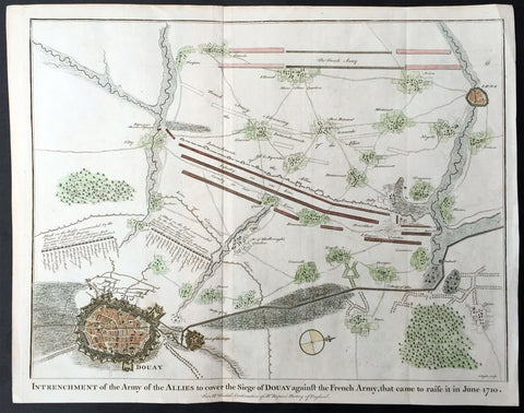
1745 N Tindal Original Antique Map Siege of Douai, Flanders, North France in 1710
- Title : Intrenchment of the Army of the Allies to cover the Siege of Douay against the French Army that came to raise it in June 1710.
- Size: 19 1/2in x 15 1/2in (495mm x 395mm)
- Ref #: 22212
- Date : 1745
- Condition: (A+) Fine Condition
Description:
This original copper-plate engraved antique map, plan of the Siege of Douai, Flanders in Northern France - during the Spanish War of Succession (1701-13) - was engraved by John Basire and was published in the 1745 edition of Nicholas Tindals Continuation of Mr. Rapin\'s History of England.
General Definitions:
Paper thickness and quality: - Heavy and stable
Paper color : - off white
Age of map color: - Early
Colors used: - Green, pink, blue
General color appearance: - Authentic
Paper size: - 19 1/2in x 15 1/2in (495mm x 395mm)
Plate size: - 19 1/2in x 15 1/2in (495mm x 395mm)
Margins: - Min 1/2in (12mm)
Imperfections:
Margins: - None
Plate area: - None
Verso: - None
Background:
A large battle plan showing both siege and works against a fortified Douai, Flanders and the detailed dispositions and battle lines of Lord Marlborough\'s army against the French, and thier attempt to lift the siege in June 1710.
Successive sieges from 1710 to 1712 during the Spanish War of Succession (1701-13), almost completely destroyed Douai by the British Army. By 1713, the town was fully integrated into France. Douai became the seat of the Parliament of Flanders.
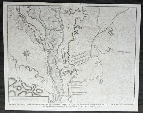
1745 Nicolas Tindal Antique Map Battle of Almenar Balaguer, Catalonia, Spain
- Title : Plan of the Country and Camps of Almanar, the one under Charles II and the other of the Enemy under the D of Anjou who was defeated by 16 Squadrons commanded by Lieut. Gen. Stanhope, July 27 1710
- Size: 19 1/2in x 15 1/2in (495mm x 395mm)
- Ref #: 22174
- Date : 1745
- Condition: (A+) Fine Condition
Description:
This original copper-plate engraved antique map, plan of the The Battle of Almenar, near Balaguer, Catalonia, Spain in 1710 - during the Spanish War of Succession (1701-13) - was engraved by John Basire and was published in the 1745 edition of Nicholas Tindals Continuation of Mr. Rapin\'s History of England.
General Definitions:
Paper thickness and quality: - Heavy and stable
Paper color : - off white
Age of map color: -
Colors used: -
General color appearance: -
Paper size: - 19 1/2in x 15 1/2in (495mm x 395mm)
Plate size: - 19 1/2in x 15 1/2in (495mm x 395mm)
Margins: - Min 1/2in (12mm)
Imperfections:
Margins: - Repair to top margin, no loss
Plate area: - Repair to top of image, no loss
Verso: - None
Background:
The Battle of Almenar took place on 27 July 1710 in the War of the Spanish Succession, between the troops of Phillip V and the Archduke Charles. Philip V\'s army having been defeated was forced to evacuate Catalonia and regroup behind the Ebro.
In spring of 1710, the Borbonic army had entered Catalonia from Aragón crossing the Segre river on March 15. On May 3, Philip V, the Borbon claimant to the throne, joined the army.
The opposing allied army, consisting of Austrian, British, and Dutch troops, was joined by Archduke Charles of Austria, the Habsburg claimant, in June.
In July, General Guido Starhemberg received reinforcements and decided to attack. He crossed the Noguera river taking up positions on the heights of Almenar.
Stanhope then crossed the Segre at Balaguer (north of Lerida) marching to the bridge of Alfarras, crossing it on 27 July.
Villadarias opened the battle with a cavalry attack which was initially successful, but the initiative was wasted by pursuing groups of fleeing enemies.
Then the British infantry attacked the left wing which fled, taking the second line with it. Then the Austrians attacked and destroyed the right wing, where Philip V risked his life fighting and was almost captured by the allies.
The Borbonic troops had to leave Catalonia and withdraw to Aragón, where the Battle of Saragossa took place on August 20.
Villadarias was relieved of his command and replaced by the Marquis de Bay.
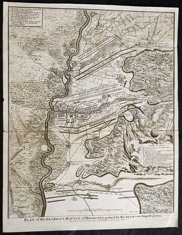
1745 Nicolas Tindal Antique Map The Battle of Blenheim, Germany in 1704
Antique Map
- Title : Plan of the Glorious Battle of Hochstet gained by the Allies on August 13.th 1704.
- Size: 21in x 17in (530mm x 430mm)
- Ref #: 15692-1
- Date : 1745
- Condition: (A+) Fine Condition
Description:
This original copper-plate engraved antique map, plan of the The Battle of Blenheim or Hochstadt, fought in Bavaria, Germany in August 1704 - during the Spanish War of Succession (1701-13) - was engraved by John Basire and was published in the 1745 edition of Nicholas Tindals Continuation of Mr. Rapins History of England.
General Definitions:
Paper thickness and quality: - Heavy and stable
Paper color : - off white
Age of map color: -
Colors used: -
General color appearance: -
Paper size: - 21in x 17in (530mm x 430mm)
Plate size: - 21in x 17in (530mm x 430mm)
Margins: - Min 1/2in (12mm)
Imperfections:
Margins: - None
Plate area: - Folds as issued
Verso: - None
Background:
The Battle of Blenheim (German: Zweite Schlacht bei Höchstädt; French Bataille de Höchstädt), fought on 13 August 1704, was a major battle of the War of the Spanish Succession. The overwhelming Allied victory ensured the safety of Vienna from the Franco-Bavarian army, thus preventing the collapse of the Grand Alliance.
Louis XIV of France sought to knock the Holy Roman Emperor, Leopold out of the war by seizing Vienna, the Habsburg capital, and gain a favourable peace settlement. The dangers to Vienna were considerable: the Elector of Bavaria and Marshal Marsins forces in Bavaria threatened from the west, and Marshal Vendômes large army in northern Italy posed a serious danger with a potential offensive through the Brenner Pass. Vienna was also under pressure from Rákóczis Hungarian revolt from its eastern approaches. Realising the danger, the Duke of Marlborough resolved to alleviate the peril to Vienna by marching his forces south from Bedburg to help maintain Emperor Leopold within the Grand Alliance.
A combination of deception and skilled administration – designed to conceal his true destination from friend and foe alike – enabled Marlborough to march 400 kilometres (250 miles) unhindered from the Low Countries to the River Danube in five weeks. After securing Donauwörth on the Danube, Marlborough sought to engage the Electors and Marsins army before Marshal Tallard could bring reinforcements through the Black Forest. However, with the Franco-Bavarian commanders reluctant to fight until their numbers were deemed sufficient, the Duke enacted a policy of plundering in Bavaria designed to force the issue. The tactic proved unsuccessful, but when Tallard arrived to bolster the Electors army, and Prince Eugene arrived with reinforcements for the Allies, the two armies finally met on the banks of the Danube in and around the small village of Blindheim, from which the English Blenheim is derived.
Blenheim was one of the battles that altered the course of the war, which until then was leaning for Louis coalition, and ended French plans of knocking the Emperor out of the war. France suffered as many as 38,000 casualties including the commander-in-chief, Marshal Tallard, who was taken captive to England. Before the 1704 campaign ended, the Allies had taken Landau, and the towns of Trier and Trarbach on the Moselle in preparation for the following years campaign into France itself. The offensive never materialised as the Grand Alliances army had to depart the Moselle to defend Liège from a French counteroffensive. The war would rage on for another decade.
Tindal, Nicolas 1687 – 1774
Nicolas Tindal was the translator and continuer of the History of England published by Paul de Rapin (1661-1725) in 1724. De Rapins publication chronicles the History of Britain from the invasion of the Romans to the death of Charles I. Very few comprehensive histories of England existed at the time and Tindal added his three-volume Continuation, of the Kingdom, from the reigns of James II to George II.
Tindal\\\'s translation of de Rapins History, was first published in 1727. Tindal enlarged the volumes in their second edition (1732) to contain notes, genealogical tables and maps of his own composition. In 1745 Tindal published Tindal’s Continuation of Mr. Rapin’s History of England. Included with this edition was an atlas containing 45 maps, battle and town plans from the Spanish War of Succession (1701-13) that were engraved by Richard William Seale and John Basire.
These maps represent battles that took place during the War of Spanish Succession, concluded by the Treaties of Utrecht. The war resulted from a dispute over who should inherit Spain and its possessions after its Habsburg rulers in 1700. The last Habsburg king of Spain, Charles II (d. 1700) had left the throne to his closest relative in female line: Philippe de France, duke of Anjou, grandson of Louis XIV (Felipe V of Spain). The closest relatives in male line, the Habsburgs of Austria, disputed this claim, and many European nations did not want to see French princes reigning over both kingdoms. The Utrecht treaties recognized Felipe V of Spain, but transferred the Spanish possessions in the Netherlands and Italy to Austria and to Savoy. To reach the goal of separating the crowns of France and Spain, the treaties required Felipe V to relinquish all claims to the French throne, and the remaining French princes to relinquish all claims to the Spanish throne.
The War of the Spanish Succession, was also known as Marlboroughs Wars, that was fought in Europe and the Mediterranean, and were the last and the bloodiest of the Wars between England and France under Louis XIV, and the first in which Britain played a major military role in European military affairs.
Paul de Rapin 1661-1725 was born in Castes and educated at the Protestant academy of Saumur. In 1685 after the death of his father he moved to England but after being unable to find employment moved to Holland and enlisted in French volunteers at Utrecht commanded by his cousin Daniel de Rapin. He accompanied the prince of Orange to England in 1688 and participated in the Irish campaigns of the siege of Carrickfergus, Battle of the Boyne and Limerick. Rapin resigned to become tutor to the Earl of Portlands son. He settled in Holland where he began work on The History of England. It was published in Holland in 1724 in 8 volumes. The work was an attempt to be exhaustive in the spirit of the eighteenth century philosophies by treating the subject from prehistoric times up to the date of publication.
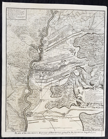
1745 Nicolas Tindal Antique Map The Battle of Blenheim, Germany in 1704
Antique Map
- Title : Plan of the Glorious Battle of Hochstet gained by the Allies on August 13.th 1704.
- Size: 21in x 17in (530mm x 430mm)
- Ref #: 22178
- Date : 1745
- Condition: (A+) Fine Condition
Description:
This original copper-plate engraved antique map, plan of the The Battle of Blenheim or Hochstadt, fought in Bavaria, Germany in August 1704 - during the Spanish War of Succession (1701-13) - was engraved by John Basire and was published in the 1745 edition of Nicholas Tindals Continuation of Mr. Rapins History of England.
General Definitions:
Paper thickness and quality: - Heavy and stable
Paper color : - off white
Age of map color: -
Colors used: -
General color appearance: -
Paper size: - 21in x 17in (530mm x 430mm)
Plate size: - 21in x 17in (530mm x 430mm)
Margins: - Min 1/2in (12mm)
Imperfections:
Margins: - None
Plate area: - Folds as issued
Verso: - None
Background:
The Battle of Blenheim (German: Zweite Schlacht bei Höchstädt; French Bataille de Höchstädt), fought on 13 August 1704, was a major battle of the War of the Spanish Succession. The overwhelming Allied victory ensured the safety of Vienna from the Franco-Bavarian army, thus preventing the collapse of the Grand Alliance.
Louis XIV of France sought to knock the Holy Roman Emperor, Leopold out of the war by seizing Vienna, the Habsburg capital, and gain a favourable peace settlement. The dangers to Vienna were considerable: the Elector of Bavaria and Marshal Marsins forces in Bavaria threatened from the west, and Marshal Vendômes large army in northern Italy posed a serious danger with a potential offensive through the Brenner Pass. Vienna was also under pressure from Rákóczis Hungarian revolt from its eastern approaches. Realising the danger, the Duke of Marlborough resolved to alleviate the peril to Vienna by marching his forces south from Bedburg to help maintain Emperor Leopold within the Grand Alliance.
A combination of deception and skilled administration – designed to conceal his true destination from friend and foe alike – enabled Marlborough to march 400 kilometres (250 miles) unhindered from the Low Countries to the River Danube in five weeks. After securing Donauwörth on the Danube, Marlborough sought to engage the Electors and Marsins army before Marshal Tallard could bring reinforcements through the Black Forest. However, with the Franco-Bavarian commanders reluctant to fight until their numbers were deemed sufficient, the Duke enacted a policy of plundering in Bavaria designed to force the issue. The tactic proved unsuccessful, but when Tallard arrived to bolster the Electors army, and Prince Eugene arrived with reinforcements for the Allies, the two armies finally met on the banks of the Danube in and around the small village of Blindheim, from which the English Blenheim is derived.
Blenheim was one of the battles that altered the course of the war, which until then was leaning for Louis coalition, and ended French plans of knocking the Emperor out of the war. France suffered as many as 38,000 casualties including the commander-in-chief, Marshal Tallard, who was taken captive to England. Before the 1704 campaign ended, the Allies had taken Landau, and the towns of Trier and Trarbach on the Moselle in preparation for the following years campaign into France itself. The offensive never materialised as the Grand Alliances army had to depart the Moselle to defend Liège from a French counteroffensive. The war would rage on for another decade.
Tindal, Nicolas 1687 – 1774
Nicolas Tindal was the translator and continuer of the History of England published by Paul de Rapin (1661-1725) in 1724. De Rapins publication chronicles the History of Britain from the invasion of the Romans to the death of Charles I. Very few comprehensive histories of England existed at the time and Tindal added his three-volume Continuation, of the Kingdom, from the reigns of James II to George II.
Tindal\\\'s translation of de Rapins History, was first published in 1727. Tindal enlarged the volumes in their second edition (1732) to contain notes, genealogical tables and maps of his own composition. In 1745 Tindal published Tindal’s Continuation of Mr. Rapin’s History of England. Included with this edition was an atlas containing 45 maps, battle and town plans from the Spanish War of Succession (1701-13) that were engraved by Richard William Seale and John Basire.
These maps represent battles that took place during the War of Spanish Succession, concluded by the Treaties of Utrecht. The war resulted from a dispute over who should inherit Spain and its possessions after its Habsburg rulers in 1700. The last Habsburg king of Spain, Charles II (d. 1700) had left the throne to his closest relative in female line: Philippe de France, duke of Anjou, grandson of Louis XIV (Felipe V of Spain). The closest relatives in male line, the Habsburgs of Austria, disputed this claim, and many European nations did not want to see French princes reigning over both kingdoms. The Utrecht treaties recognized Felipe V of Spain, but transferred the Spanish possessions in the Netherlands and Italy to Austria and to Savoy. To reach the goal of separating the crowns of France and Spain, the treaties required Felipe V to relinquish all claims to the French throne, and the remaining French princes to relinquish all claims to the Spanish throne.
The War of the Spanish Succession, was also known as Marlboroughs Wars, that was fought in Europe and the Mediterranean, and were the last and the bloodiest of the Wars between England and France under Louis XIV, and the first in which Britain played a major military role in European military affairs.
Paul de Rapin 1661-1725 was born in Castes and educated at the Protestant academy of Saumur. In 1685 after the death of his father he moved to England but after being unable to find employment moved to Holland and enlisted in French volunteers at Utrecht commanded by his cousin Daniel de Rapin. He accompanied the prince of Orange to England in 1688 and participated in the Irish campaigns of the siege of Carrickfergus, Battle of the Boyne and Limerick. Rapin resigned to become tutor to the Earl of Portlands son. He settled in Holland where he began work on The History of England. It was published in Holland in 1724 in 8 volumes. The work was an attempt to be exhaustive in the spirit of the eighteenth century philosophies by treating the subject from prehistoric times up to the date of publication.
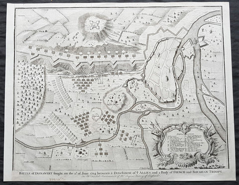
1745 Nicolas Tindal Large Antique Map The Battle of Schellenberg, Germany 1704
- Title : Battle of Donawert fought on the 2nd of June 1704 between a detachment of ye Allies and a body of French and Bavarian Troops
- Size: 20in x 16in (510mm x 410mm)
- Condition: (A+) Fine Condition
- Date : 1745
- Ref #: 22160
Description:
This large original antique copper-plate engraved military map of the Battle of Schellenberg, also known as the Battle of Donauwörth in the Donau-Ries district of Swabia, in Bavaria, Germany - during the Spanish War of Succession - was engraved by John Basire and published in the 1745 edition of Nicholas Tindals Continuation of Mr. Rapins History of England.
General Definitions:
Paper thickness and quality: - Heavy and stable
Paper color : - off white
Age of map color: -
Colors used: -
General color appearance: -
Paper size: - 20in x 16in (510mm x 410mm)
Plate size: - 20in x 16in (510mm x 410mm)
Margins: - Min 1/2in (10mm)
Imperfections:
Margins: - None
Plate area: - Folds as issued
Verso: - None
The Battle of Schellenberg, also known as the Battle of Donauwörth, was fought on 2 July 1704 during the War of the Spanish Succession. The engagement was part of the Duke of Marlboroughs campaign to save the Habsburg capital of Vienna from a threatened advance by King Louis XIVs Franco-Bavarian forces ranged in southern Germany. Marlborough had commenced his 400 km march from Bedburg, near Cologne, on 19 May; within five weeks he had linked his forces with those of the Margrave of Baden, before continuing on to the river Danube. Once in southern Germany, the Allies task was to induce Max Emanuel, the Elector of Bavaria, to abandon his allegiance to Louis XIV and rejoin the Grand Alliance; but to force the issue, the Allies first needed to secure a fortified bridgehead and magazine on the Danube, through which their supplies could cross to the south of the river into the heart of the Electors lands. For this purpose, Marlborough selected the town of Donauwörth.
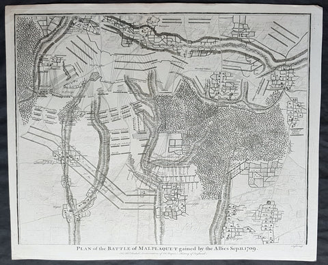
1745 Nicolas Tindal Original Antique Map Battle of Malplaquet, Northern France in 1709
- Title : Plan of the Battle of Malplaquet gained by the Allies Sep. 11 1709.
- Size: 19 1/2in x 15 1/2in (495mm x 395mm)
- Ref #: 22173
- Date : 1745
- Condition: (A+) Fine Condition
Description:
This original copper-plate engraved antique map, plan of the Battle of Malplaquet, northern France in 1709 - during the Spanish War of Succession (1701-13) - was engrvaed by John Basire and was published in the 1745 edition of Nicholas Tindals Continuation of Mr. Rapin\'s History of England.
General Definitions:
Paper thickness and quality: - Heavy and stable
Paper color : - off white
Age of map color: -
Colors used: -
General color appearance: -
Paper size: - 19 1/2in x 15 1/2in (495mm x 395mm)
Plate size: - 19 1/2in x 15 1/2in (495mm x 395mm)
Margins: - Min 1/2in (12mm)
Imperfections:
Margins: - None
Plate area: - None
Verso: - None
Background:
The Battle of Malplaquet, fought on 11 September 1709, was one of the main battles of the War of the Spanish Succession. Led by the Duke of Marlborough, the army of the Grand Alliance attacked and defeated the French army near Malplaquet under the command of Marshal Villars. The heavy losses suffered by the Allies caused the battle to be considered a Pyrrhic victory.
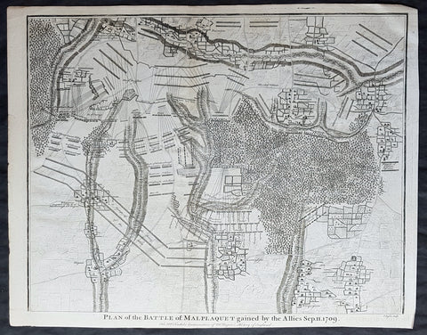
1745 Nicolas Tindal Original Antique Map Battle of Malplaquet, Northern France in 1709
- Title : Plan of the Battle of Malplaquet gained by the Allies Sep. 11 1709.
- Size: 19 1/2in x 15 1/2in (495mm x 395mm)
- Ref #: 15659
- Date : 1745
- Condition: (A+) Fine Condition
Description:
This original copper-plate engraved antique map, plan of the Battle of Malplaquet, northern France in 1709 - during the Spanish War of Succession (1701-13) - was engrvaed by John Basire and was published in the 1745 edition of Nicholas Tindals Continuation of Mr. Rapin\'s History of England.
General Definitions:
Paper thickness and quality: - Heavy and stable
Paper color : - off white
Age of map color: -
Colors used: -
General color appearance: -
Paper size: - 19 1/2in x 15 1/2in (495mm x 395mm)
Plate size: - 19 1/2in x 15 1/2in (495mm x 395mm)
Margins: - Min 1/2in (12mm)
Imperfections:
Margins: - None
Plate area: - None
Verso: - None
Background:
The Battle of Malplaquet, fought on 11 September 1709, was one of the main battles of the War of the Spanish Succession. Led by the Duke of Marlborough, the army of the Grand Alliance attacked and defeated the French army near Malplaquet under the command of Marshal Villars. The heavy losses suffered by the Allies caused the battle to be considered a Pyrrhic victory.
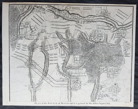
1745 Nicolas Tindal Original Antique Map Battle of Malplaquet, Northern France in 1709
- Title : Plan of the Battle of Malplaquet gained by the Allies Sep. 11 1709.
- Size: 19 1/2in x 15 1/2in (495mm x 395mm)
- Ref #: 22154
- Date : 1745
- Condition: (A+) Fine Condition
Description:
This original copper-plate engraved antique map, plan of the Battle of Malplaquet, northern France in 1709 - during the Spanish War of Succession (1701-13) - was engrvaed by John Basire and was published in the 1745 edition of Nicholas Tindals Continuation of Mr. Rapin\'s History of England.
General Definitions:
Paper thickness and quality: - Heavy and stable
Paper color : - off white
Age of map color: -
Colors used: -
General color appearance: -
Paper size: - 19 1/2in x 15 1/2in (495mm x 395mm)
Plate size: - 19 1/2in x 15 1/2in (495mm x 395mm)
Margins: - Min 1/2in (12mm)
Imperfections:
Margins: - None
Plate area: - None
Verso: - None
Background:
The Battle of Malplaquet, fought on 11 September 1709, was one of the main battles of the War of the Spanish Succession. Led by the Duke of Marlborough, the army of the Grand Alliance attacked and defeated the French army near Malplaquet under the command of Marshal Villars. The heavy losses suffered by the Allies caused the battle to be considered a Pyrrhic victory.
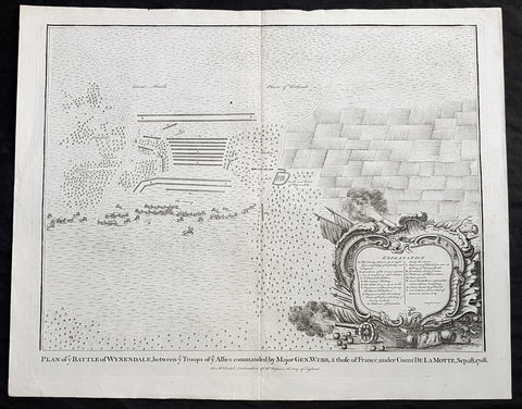
1745 Nicolas Tindal Original Antique Map Battle of Wijnendale Flanders Belgium in 1708
Antique Map
- Title : Plan of the Battle of Wynendale, between ye Troops of ye Allies commanded by Major Gen. Webb & those of France under count de la Motte Sep. 28, 1708
- Size: 19 1/2in x 15 1/2in (495mm x 395mm)
- Ref #: 22165
- Date : 1745
- Condition: (A+) Fine Condition
Description:
This original copper-plate engraved antique map, plan of the The Battle of Wijnendale, Flanders, Belgium in 1708 - during the Spanish War of Succession (1701-13) - was engraved by John Basire and was published in the 1745 edition of Nicholas Tindals Continuation of Mr. Rapin\'s History of England.
General Definitions:
Paper thickness and quality: - Heavy and stable
Paper color : - off white
Age of map color: -
Colors used: -
General color appearance: -
Paper size: - 19 1/2in x 15 1/2in (495mm x 395mm)
Plate size: - 19 1/2in x 15 1/2in (495mm x 395mm)
Margins: - Min 1/2in (12mm)
Imperfections:
Margins: - None
Plate area: - None
Verso: - None
Background:
The Battle of Wijnendale was a battle in the War of the Spanish Succession fought on 28 September 1708 near Wijnendale, Flanders, between an allied force protecting a convoy for the Siege of Lille (1708) and forces of Bourbon France and Spain. It ended in a victory for the allies, leading to the taking of Lille.
After their great victory in the Battle of Oudenaarde (11 July 1708), Marlborough and Prince Eugene of Savoy decided to besiege Lille. But Lille was very well defended by modern fortifications designed by Vauban and a garrison of 16,000 men. The allied siege didn\'t go as well as planned and a lack of ammunition was imminent. To make things worst, the supply lines from the east were cut by the French, so the only remaining line of supply was by ship from England to the port of Ostend, some 75 km from Lille.
Marlborough ordered the necessary goods to be shipped to Ostend and a large convoy of 700 slow wagons was organised there to travel further over land to Lille. The convoy was protected by 6,000 infantry and 1,500 cavalry under command of general-major John Richmond Webb.
The commander of the French garrison of Bruges, Count de la Mothe, was informed of the convoy and gathered a force of 22,000 to 24,000 men towards Wijnendale to intercept the convoy.
Webb was aware of the advancing French army and knew a confrontation was unavoidable. He drew up a plan to compensate for his numerical disadvantage. Using the wooded landscape around Wijnendale, he chose an open spot, flanked on both sides by woods and hedges. He placed his troops in two long lines, closing off this open space. Later a third line was formed with reinforcements coming from Oudenburg. Meanwhile, behind these lines, the convoy continued slowly towards Lille.
While Webb was deploying his troops, Prussian general Carl von Lottum, with only 150 cavalry harassed the approaching French army, gaining valuable time, and preventing de la Mothe to gather knowledge of the terrain and the plans of the allies.
Having arrived at the open space, de la Mothe, expecting an easy victory, deployed his army as expected. Between 4 and 5 pm the French artillery opened fire. When de la Mothe saw the effects on the enemy were limited, he ordered his infantry forward. The large French force was hampered by the narrow terrain and suffered badly from the fire of the allied first line, which held its ground. Then Webb ordered the Prussian, Hanoverian and Dutch regiments who were hidden in the woods on both flanks, to open fire. Despite suffering heavy casualties, de la Mothe ordered a second attack, which initially pushed the allied first line back. But with the help of the second line and the continuous fire from the flanks, the French were stopped and forced to withdraw and leave the battlefield.
When the battle was as good as won, allied cavalry under command of William Cadogan arrived at the battlefield. He was sent from Lille by Marlborough, who was worried about the convoy.
The toll of this two-hour battle was heavy: 3,000 to 4,000 French and Spanish soldiers were killed or wounded. The allies lost 900 dead and wounded.
The convoy reached Lille intact on 29 September, allowing the siege to continue. Three weeks later, on 22 October, the city was taken.
For political reasons, Marlborough gave in his initial dispatch the credit for the victory to William Cadogan, also a Whig. But Webb subsequently received full credit and the thanks of Parliament for the action, and the following year he was promoted to Lieutenant-General. From this point onwards Webb became the centre of Tory agitation against Marlborough.
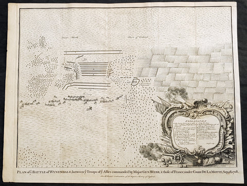
1745 Nicolas Tindal Original Antique Map Battle of Wijnendale Flanders Belgium in 1708
Antique Map
- Title : Plan of the Battle of Wynendale, between ye Troops of ye Allies commanded by Major Gen. Webb & those of France under count de la Motte Sep. 28, 1708
- Size: 19 1/2in x 15 1/2in (495mm x 395mm)
- Ref #: 15662
- Date : 1745
- Condition: (A+) Fine Condition
Description:
This original copper-plate engraved antique map, plan of the The Battle of Wijnendale, Flanders, Belgium in 1708 - during the Spanish War of Succession (1701-13) - was engraved by John Basire and was published in the 1745 edition of Nicholas Tindals Continuation of Mr. Rapin\'s History of England.
General Definitions:
Paper thickness and quality: - Heavy and stable
Paper color : - off white
Age of map color: -
Colors used: -
General color appearance: -
Paper size: - 19 1/2in x 15 1/2in (495mm x 395mm)
Plate size: - 19 1/2in x 15 1/2in (495mm x 395mm)
Margins: - Min 1/2in (12mm)
Imperfections:
Margins: - None
Plate area: - None
Verso: - None
Background:
The Battle of Wijnendale was a battle in the War of the Spanish Succession fought on 28 September 1708 near Wijnendale, Flanders, between an allied force protecting a convoy for the Siege of Lille (1708) and forces of Bourbon France and Spain. It ended in a victory for the allies, leading to the taking of Lille.
After their great victory in the Battle of Oudenaarde (11 July 1708), Marlborough and Prince Eugene of Savoy decided to besiege Lille. But Lille was very well defended by modern fortifications designed by Vauban and a garrison of 16,000 men. The allied siege didn\'t go as well as planned and a lack of ammunition was imminent. To make things worst, the supply lines from the east were cut by the French, so the only remaining line of supply was by ship from England to the port of Ostend, some 75 km from Lille.
Marlborough ordered the necessary goods to be shipped to Ostend and a large convoy of 700 slow wagons was organised there to travel further over land to Lille. The convoy was protected by 6,000 infantry and 1,500 cavalry under command of general-major John Richmond Webb.
The commander of the French garrison of Bruges, Count de la Mothe, was informed of the convoy and gathered a force of 22,000 to 24,000 men towards Wijnendale to intercept the convoy.
Webb was aware of the advancing French army and knew a confrontation was unavoidable. He drew up a plan to compensate for his numerical disadvantage. Using the wooded landscape around Wijnendale, he chose an open spot, flanked on both sides by woods and hedges. He placed his troops in two long lines, closing off this open space. Later a third line was formed with reinforcements coming from Oudenburg. Meanwhile, behind these lines, the convoy continued slowly towards Lille.
While Webb was deploying his troops, Prussian general Carl von Lottum, with only 150 cavalry harassed the approaching French army, gaining valuable time, and preventing de la Mothe to gather knowledge of the terrain and the plans of the allies.
Having arrived at the open space, de la Mothe, expecting an easy victory, deployed his army as expected. Between 4 and 5 pm the French artillery opened fire. When de la Mothe saw the effects on the enemy were limited, he ordered his infantry forward. The large French force was hampered by the narrow terrain and suffered badly from the fire of the allied first line, which held its ground. Then Webb ordered the Prussian, Hanoverian and Dutch regiments who were hidden in the woods on both flanks, to open fire. Despite suffering heavy casualties, de la Mothe ordered a second attack, which initially pushed the allied first line back. But with the help of the second line and the continuous fire from the flanks, the French were stopped and forced to withdraw and leave the battlefield.
When the battle was as good as won, allied cavalry under command of William Cadogan arrived at the battlefield. He was sent from Lille by Marlborough, who was worried about the convoy.
The toll of this two-hour battle was heavy: 3,000 to 4,000 French and Spanish soldiers were killed or wounded. The allies lost 900 dead and wounded.
The convoy reached Lille intact on 29 September, allowing the siege to continue. Three weeks later, on 22 October, the city was taken.
For political reasons, Marlborough gave in his initial dispatch the credit for the victory to William Cadogan, also a Whig. But Webb subsequently received full credit and the thanks of Parliament for the action, and the following year he was promoted to Lieutenant-General. From this point onwards Webb became the centre of Tory agitation against Marlborough.
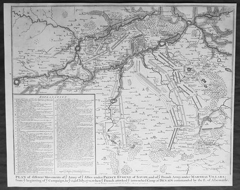
1745 Nicolas Tindal Original Antique Map Battle Plan of Denain, France in 1712
- Title : Plan of the movements of ye Armies of ye Allies under Prince Eugene of Savoy and of ye French Army under Marshal Villars; from ye beginning of ye campaign to ye 24th July 1712, when ye French attacked ye intrenchement Camp at Denain commanded by the E. of Albemarle
- Size: 19 1/2in x 15 1/2in (495mm x 395mm)
- Ref #: 22155
- Date : 1745
- Condition: (A+) Fine Condition
Description:
This original copper-plate engraved antique map, battle plan of the Battle of Denain - during the Spanish War of Succession (1701-13) - centering on the cities of Douai & Bouchain in northern France, was published in the 1745 edition of Nicholas Tindals Continuation of Mr. Rapin\'s History of England.
General Definitions:
Paper thickness and quality: - Heavy and stable
Paper color : - off white
Age of map color: -
Colors used: -
General color appearance: -
Paper size: - 19 1/2in x 15 1/2in (495mm x 395mm)
Plate size: - 19 1/2in x 15 1/2in (495mm x 395mm)
Margins: - Min 1/2in (12mm)
Imperfections:
Margins: - None
Plate area: - None
Verso: - None
Background:
The Battle of Denain was fought on 24 July 1712, as part of the War of the Spanish Succession. It resulted in a French victory under Marshal Villars against Dutch and Austrian forces under Prince Eugene of Savoy.
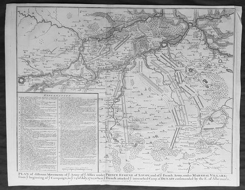
1745 Nicolas Tindal Original Antique Map Battle Plan of Denain, France in 1712
- Title : Plan of the movements of ye Armies of ye Allies under Prince Eugene of Savoy and of ye French Army under Marshal Villars; from ye beginning of ye campaign to ye 24th July 1712, when ye French attacked ye intrenchement Camp at Denain commanded by the E. of Albemarle
- Size: 19 1/2in x 15 1/2in (495mm x 395mm)
- Ref #: 15689
- Date : 1745
- Condition: (A+) Fine Condition
Description:
This original copper-plate engraved antique map, battle plan of the Battle of Denain - during the Spanish War of Succession (1701-13) - centering on the cities of Douai & Bouchain in northern France, was published in the 1745 edition of Nicholas Tindals Continuation of Mr. Rapin\'s History of England.
General Definitions:
Paper thickness and quality: - Heavy and stable
Paper color : - off white
Age of map color: -
Colors used: -
General color appearance: -
Paper size: - 19 1/2in x 15 1/2in (495mm x 395mm)
Plate size: - 19 1/2in x 15 1/2in (495mm x 395mm)
Margins: - Min 1/2in (12mm)
Imperfections:
Margins: - None
Plate area: - None
Verso: - None
Background:
The Battle of Denain was fought on 24 July 1712, as part of the War of the Spanish Succession. It resulted in a French victory under Marshal Villars against Dutch and Austrian forces under Prince Eugene of Savoy.
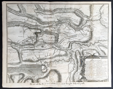
1745 Tindal Antique Battle Map of Oudenaarde, Belgium in 1708 - Britain & France
- Title : Plan of the Battle of Oudenard fought July 11th 1708
- Size: 19 1/2in x 15 1/2in (495mm x 395mm)
- Ref #: 15661
- Date : 1745
- Condition: (A+) Fine Condition
Description:
This original copper-plate engraved antique map, a battle plan of the Battle of Oudenard or Oudenaarde, in Flemish Belgium, in 1708 between Britain & its allies and France and its allies - during the Spanish War of Succession (1701-13) - was engraved by John Basire and was published in the 1745 edition of Nicholas Tindals Continuation of Mr. Rapin\'s History of England.
General Definitions:
Paper thickness and quality: - Heavy and stable
Paper color : - off white
Age of map color: -
Colors used: -
General color appearance: -
Paper size: - 19 1/2in x 15 1/2in (495mm x 395mm)
Plate size: - 19 1/2in x 15 1/2in (495mm x 395mm)
Margins: - Min 1/2in (12mm)
Imperfections:
Margins: - None
Plate area: - Folds as issued
Verso: - None
Background:
The Battle of Oudenarde (or Oudenaarde) was a battle in the War of the Spanish Succession fought on 11 July 1708 between the forces of Great Britain, the Dutch Republic and the Holy Roman Empire on the one side and those of France on the other. It took place at Oudenaarde (now in Belgium) and was a great victory for the allies.
Great Britain, the Netherlands, and the Holy Roman Empire were horrified at the thought of a union between Spain and France which caused them to ally against France, beginning the War of the Spanish Succession. The commander of the allied armies was John Churchill, 1st Duke of Marlborough, whose chief deputy was the commander of the Empire\'s army Prince Eugène of Savoy, who was his close friend.
Meanwhile, the two French army commanders were very quarrelsome. Louis Joseph, duc de Vendôme was a seasoned, experienced soldier. The Duke of Burgundy had considerably less experience and owed his position to the fact he was the grandson of the King, Louis XIV of France.
Marlborough\'s army consisted of about 80,000 men (113 infantry battalions and 180 cavalry squadrons) just south of Brussels. Eugène\'s forces were assembled at Coblenz. These two areas were somewhat far apart, while the French army\'s 85,000 soldiers (139 battalions and 204 squadrons) were concentrated near Mons.
At this time, the French commanders began quarrelling. Vendôme wanted to attack the city of Huy, which could draw Marlborough in pursuit. The eventual plan adopted, however, (under orders from Louis XIV) was to attack Flanders. The army moved eastward, until they reached the city of Braine-l\'Alleud, which was about 25 km south of Brussels, and also threatened the nearby city of Leuven. Marlborough placed his forces a few miles south of Leuven, in order to cover both threatened cities.
The French army then remained inactive for more than a month. This apparently allowed the extremely behind schedule Eugène to bring his army from the Rhine River. On 5 July, however, the French unexpectedly moved west, taking the cities of Bruges and Ghent (although about 300 British soldiers held out in Ghent for a few days). This extremely demoralized Marlborough and his army, and he did not recover until Eugène was at his side.
The French army had the entire length of the Scheldt River from the French border to the newly taken city of Ghent. Only one British fortress remained: Oudenaarde. If they took that city, Marlborough\'s army would be cut off from the coast, causing them to lose communications with England.
Marlborough detected this objective, and also correctly guessed the method by which the French troops would attempt to take it. They would march down the east bank of the Scheldt (closer to Marlborough\'s troops), while leaving a large covering force between the two opposing armies. The French army marched on 8 July, toward the city of Lessines. However, Marlborough made one of the most inspired forced marches in history, taking the city on 10 July. This forced the French commanders to attempt simply to march across the Scheldt and thereby take the city of Oudenaarde.
Again Marlborough ordered a forced march. This time, though, he ordered 11,000 troops to hold the main crossing point across the Scheldt, under the command of his Quartermaster General, William Cadogan. Cadogan\'s force built 5 additional pontoon bridges to allow Marlborough to get his 80,000-strong army across the river, until French foragers discovered the allied presence around 09:00 AM.
Cadogan, a superb Irish cavalry commander, ordered some dragoons, under Danish General Jørgen Rantzau, to take prisoners from the French advance guard. Many of those troops escaped and alerted Lieutenant General Charles-Armand de Gontaut, duc de Biron, who commanded the vanguard, of the presence of Allied troops on the west bank.
When de Biron advanced, he was disagreeably surprised by the large number of Allied cavalry already across the river, along with the approaching Allied infantry. Although he was ordered to attack by Vendôme, he hesitated upon seeing the reinforced line of 20 battalions (including the four that had been left to guard the pontoon bridges). Biron\'s own forces comprised only 7 battalions and 20 squadrons. He had been given reliable advice that cavalry could not negotiate the marshy terrain in the area and decided not to attempt a crossing. At this time, Eugène, along with 20 squadrons of Prussian cavalry, moved across the river and occupied crucial positions.
While Biron\'s troops were manoeuvring, the leading British infantry brigade had arrived, under the inexperienced but gifted John Campbell, 2nd Duke of Argyll. Cadogan, with authority from Marlborough, attacked Biron\'s 7 battalions (of Swiss mercenaries) with his soldiers (mainly cavalry). The isolated Swiss mercenaries were immediately pushed back and the Allied force destroyed Biron\'s squadrons, until they reached a large mass of French cavalry, at which point they were forced to retire, outnumbered. The force which performed this action was Rantzau\'s cavalry, with the future King George II of England among them.
Burgundy, making another mistake, decided to attack (over protests by Vendôme). The French right wing began to attack the Allied positions near Eine, while the left wing (for an unknown reason) remained stationary near Huise. A very strong position was held by the Allied left wing. 28 cavalry squadrons protected the right flank of Cadogan\'s infantry, which would receive the attack (which proceeded at about 4:00 p.m.).
Burgundy ordered the assault, which landed on Prussian cavalry squadrons under Dubislav Gneomar von Natzmer. Although hard fighting ensued, the attack was dispersed. Then, Vendôme made a dubious decision and led an attack of twelve regiments, fighting hand-to-hand with a half-pike. This meant that while one commander (Burgundy) was in his headquarters, with no view of the battle, the other was fighting, with no possibility of control.
Most historians agree that the weakened Allied right flank would have been destroyed, had the French left wing attacked. Vendôme realized this, asking Burgundy for permission to attack with the left wing. Burgundy sent a messenger with a refusal but the messenger failed to deliver the message. The situation worsened with Vendôme believing that an attack would support his troops, who were lengthening their line, threatening to envelop the Allied left flank. As Argyll\'s regiments approached, they lengthened the Allied line but too slowly and not great enough in extent, to prevent the French from threatening such an envelopment.
Marlborough moved his headquarters to the left flank, giving Eugène command of the right flank (which still checked the left wing of the French army). While the right was under pressure, Marlborough made a brilliant command decision: he placed 18 newly arrived Hessian and Hanoverian battalions in the left flank, while replacing 20 of Prussian General Carl von Lottum\'s battalions, moving them to Eugène\'s support. This moved fresh troops to the critical left, while reinforcing the right flank (and resting Lottum\'s troops). Marlborough then began formulating a new plan of double encirclement. He had the entire Dutch Army, under Field Marshal Count Hendrik Overkirk, an experienced military officer. His force was unable to cross the collapsed pontoon bridges near Oudenaarde, forcing him to use the stone bridges in the city, delaying him for an hour. Marlborough went ahead with his plan, having Eugène\'s cavalry charge towards Burgundy\'s headquarters. The French Household Cavalry, the Maison du Roi, were able to turn them back and Marlborough, with only the 18 Hessian and Hanoverian battalions, was unable to do much other than keep the French right in check. At about 20:30, Overkirk\'s troops had arrived and flanked the French right wing. This was in conjunction with a dual attack by Marlborough and Eugène. Overkirk\'s manoeuvre was successful, with much of the French army being routed or captured but there was not enough daylight to complete the manoeuvre.
The French army retired to Ghent, with its commanders quarreling; only darkness and a few broken pontoon bridges saved the army from destruction. For unknown reasons, about half of the French army was kept in reserve, without participating at all. There was a great mass of French cavalry and infantry in some raised ground north of the Norken River and many of Burgundy\'s troops remained inactive. There were many bad decisions in the French army. The cavalry had remained in reserve, mainly because of the advice that the ground was impassable. The entire left wing (the troops under Burgundy and the large mass north of the Norken) was kept in reserve. They could easily have destroyed the rather weak right wing of the Allied army. Had a concerted attack been carried out, with Vendôme attacking with his main body to envelop the Allied right, while Burgundy attacked with the left (before Overkirk and the rest of Argyll\'s troops arrived), the French army could have easily won. The French army lost about 14–15,000 soldiers (about 8,000 of whom were prisoners) and 25 guns, while the Allies lost fewer than 3,000.
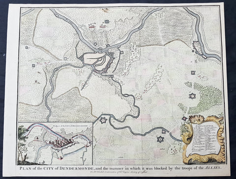
1745 Tindal Antique Map Battle Plan & View Siege of Dendermonde, Belgium in 1706
- Title : Plan of the City of Dendermonde, and the manner in which it was blocked by the troops of the Allies
- Size: 19 1/2in x 15 1/2in (495mm x 395mm)
- Ref #: 22157
- Date : 1745
- Condition: (A+) Fine Condition
Description:
This beautifully hand coloured original copper-plate engraved antique map, battle plan & birds eye view of the Belgium city of Dendermonde and surrounding regions during the siege of Dendermonde in 1706 - during the Spanish War of Succession (1701-13) - was engraved by John Basire and was published in the 1745 edition of Nicholas Tindals Continuation of Mr. Rapin\'s History of England.
General Definitions:
Paper thickness and quality: - Heavy and stable
Paper color : - off white
Age of map color: - Early
Colors used: - Pink, blue, green, yellow
General color appearance: - Authentic
Paper size: - 19 1/2in x 15 1/2in (495mm x 395mm)
Plate size: - 19 1/2in x 15 1/2in (495mm x 395mm)
Margins: - Min 1/2in (12mm)
Imperfections:
Margins: - None
Plate area: - Folds as issued
Verso: - None
Background:
Dendermonde is a Belgian city and municipality located in the Flemish province of East Flanders in the Denderstreek. The municipality comprises the city of Dendermonde proper and the towns of Appels, Baasrode, Grembergen, Mespelare, Oudegem, Schoonaarde, and Sint-Gillis-bij-Dendermonde. Dendermonde is located at the mouth of the river Dender, where it flows into the Scheldt. The town has a long-standing (folkloric) feud with Aalst (situated south along the same river), which dates back from the Middle Ages.
The city is an administrative, commercial, educational, and medical centre for the surrounding region. The current Mayor of Dendermonde is Piet Buyse (Christian Democratic and Flemish).
Some interesting La-Tène artifacts were found in Appels, proof that this region of the Scheldt was inhabited in prehistory. Grave sites from the 2nd and 6th century also attest to dense settlement in Gallo-Roman and Merovingian times. In 843, the Treaty of Verdun placed Dendermonde in Lotharingia. After the Norman invasions of 883, however, Baldwin II took over the region and incorporated it into the German part of the newly founded County of Flanders.
Otto II built a fort here in the 10th century, encouraging further settlements in the area. The town received its city charter in 1233 and grew quickly after that thanks to a thriving cloth industry. Several cloisters, chapels and churches, and a fortified defensive wall were built as well. A cloth hall and belfry were erected on the market square in the mid 14th century. The town’s prosperity, however, gave rise to severe competition with cities such as Ghent and to occasional attacks and plunders by neighbours. In 1384, the whole area came under the control of the Valois dukes of Burgundy.
The 16th century saw a decline in Dendermonde’s fortunes. In 1572 Dendermonde was conquered by William the Silent. The same year however Spanish troops under Duke Alexander Farnese of Parma, took over the city, looted and mostly destroyed it. A decade later, the Spaniards built their own fortress between the Dender and the Scheldt. In 1667, it was France’s turn to advance on the city, but the allied troops of the Netherlands and England, under the Duke of Marlborough, caused the heaviest damage in 1706. The city was then fortified by the Austrians against further French ambitions. After a last siege by Louis XV, the city could finally breathe to the point that the fortifications were dismantled a few decades later.
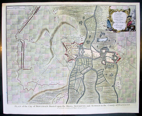
1745 Tindal Antique Map Battle Plan of Siege of Bouchain, Calais, France in 1711
- Title : Plan of the City of Bouchain Situated upon the Rivers Sensette and Scheld in the County of Hainault
- Size: 19 1/2in x 15 1/2in (495mm x 395mm)
- Ref #: 22198
- Date : 1745
- Condition: (A+) Fine Condition
Description:
This beautifully hand coloured original copper-plate engraved antique map, battle plan & birds eye view of the French city of Bouchain on the Schedlt River, in the Pas-de-Calais dept. in northern France - during the Spanish War of Succession (1701-13) - was engraved by John Basire and was published in the 1745 edition of Nicholas Tindals Continuation of Mr. Rapin\'s History of England.
General Definitions:
Paper thickness and quality: - Heavy and stable
Paper color : - off white
Age of map color: - Early
Colors used: - Pink, blue, green, yellow
General color appearance: - Authentic
Paper size: - 19 1/2in x 15 1/2in (495mm x 395mm)
Plate size: - 19 1/2in x 15 1/2in (495mm x 395mm)
Margins: - Min 1/2in (12mm)
Imperfections:
Margins: - None
Plate area: - Folds as issued
Verso: - None
Background:
The Siege of Bouchain (9 August – 12 September 1711), following the Passage of the Lines of Ne Plus Ultra (5 August 1711), was a siege of the War of the Spanish Succession, and the last major victory of John Churchill, 1st Duke of Marlborough. Marlborough broke through the French defensive lines and took Bouchain after a siege of 34 days. Its capture left Cambrai the only French-held fortress between the allied army and Paris.
Throughout the early summer of 1711 Marlborough\'s army, having taken the important fortress of Douai the previous year, manoeuvred indecisively in northern France, blocked by the French Lines of Ne Plus Ultra – a massive series of fieldworks stretching from the Channel coast to the Ardennes at Namur. The allied army had been weakened by the withdrawal of Prince Eugene\'s army to cover the upper Rhine, as the deposed Elector of Bavaria attempted to take advantage of the disruption caused by the death of the Emperor Joseph. On 6 July, Marlborough captured the small fortress of Arleux, just to the north of the Lines, west of Bouchain, both to deny its use to the French as a sally-port, and to secure the water supply to Douai, which could be cut off by damming the canal that supplied the town. The Duke was then wrong-footed by Villars as the French army crossed the Lines on 22/23 July and retook Arleux, with the allied army too far to the west to intervene in time, and the defences were levelled before the French retreated back across the Lines. Marlborough, initially furious, soon retook the initiative by marching his army as if to assault the Lines near Arras, and carrying out a detailed personal reconnaissance there on 4 August in full view of Villars\' covering army. That night the army struck camp, leaving their campfires burning to deceive the French, and marched eastwards to Arleux. At midnight a force from Douai under Cadogan crossed the unguarded French lines, and by 8 am the advance guard of the main army was also crossing over. Villars, arriving on the scene with a few hundred cavalry, realised he had been outmanoeuvred, and though he attempted to offer battle in front of Bourlon Wood, Marlborough declined to attack, the Marshal\'s position being even stronger than the one in which he had given Marlborough\'s army such a mauling two years earlier at Malplaquet. He thus drew off and attempted to hinder Marlborough\'s siege of Bouchain which followed.
To defend the town Bouchain\'s governor, de Ravignau, had some 5,000 men against Marlborough\'s besieging army of 30,000, and the advantage of one of the strongest fortresses left to France, surrounded by the marshy land of the confluence of the rivers Scheldt and Sensée. In addition, Villars\' strong army had taken up position to the west of the allied camp, and had managed to open a tenuous link to the besieged garrison. Marlborough responded by using earthwork gun batteries to counter Villars, used a crack assault force managed by 18 August to once more cut the Marshal\'s communication with Bouchain, and established a fieldwork-protected corridor from the siege camp to his main supply port at Marchiennes on the Scarpe. Frequent raids by Villars on both the supply convoys on the Scarpe, and towards Douai, failed to interrupt the siege, and the garrison marched out to become prisoners of war on 13 September 1711.
Bouchain was Marlborough\'s last campaign. On the last day of the year he was stripped of his position as Captain-General, and of all his other offices. Command of the army on the continent for the campaign of 1712 was given to the Duke of Ormonde, and strict limitations were placed on his freedom of movement. Particularly he was prohibited from engaging the French in battle, as Anglo-French peace talks were well advanced, and the opportunity of seizing Cambrai and marching on Paris, opened by Marlborough\'s gains the year before, was abandoned. Before the year was out, the British army would withdraw from the alliance, leaving the remaining allies, under Eugene of Savoy to be defeated at Denain.
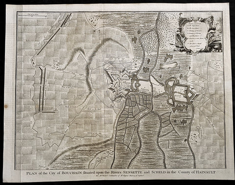
1745 Tindal Antique Map Battle Plan of Siege of Bouchain, Calais, France in 1711
Antique Map
- Title : Plan of the City of Bouchain Situated upon the Rivers Sensette and Scheld in the County of Hainault
- Size: 19 1/2in x 15 1/2in (495mm x 395mm)
- Ref #: 22198
- Date : 1745
- Condition: (A+) Fine Condition
Description:
This original copper-plate engraved antique map, battle plan & birds eye view of the French city of Bouchain on the Schedlt River, in the Pas-de-Calais dept. in northern France - during the Spanish War of Succession (1701-13) - was engraved by John Basire and was published in the 1745 edition of Nicholas Tindals Continuation of Mr. Rapin\'s History of England.
General Definitions:
Paper thickness and quality: - Heavy and stable
Paper color : - off white
Age of map color: -
Colors used: -
General color appearance: -
Paper size: - 19 1/2in x 15 1/2in (495mm x 395mm)
Plate size: - 19 1/2in x 15 1/2in (495mm x 395mm)
Margins: - Min 1/2in (12mm)
Imperfections:
Margins: - None
Plate area: - Folds as issued
Verso: - None
Background:
The Siege of Bouchain (9 August – 12 September 1711), following the Passage of the Lines of Ne Plus Ultra (5 August 1711), was a siege of the War of the Spanish Succession, and the last major victory of John Churchill, 1st Duke of Marlborough. Marlborough broke through the French defensive lines and took Bouchain after a siege of 34 days. Its capture left Cambrai the only French-held fortress between the allied army and Paris.
Throughout the early summer of 1711 Marlborough\'s army, having taken the important fortress of Douai the previous year, manoeuvred indecisively in northern France, blocked by the French Lines of Ne Plus Ultra – a massive series of fieldworks stretching from the Channel coast to the Ardennes at Namur. The allied army had been weakened by the withdrawal of Prince Eugene\'s army to cover the upper Rhine, as the deposed Elector of Bavaria attempted to take advantage of the disruption caused by the death of the Emperor Joseph. On 6 July, Marlborough captured the small fortress of Arleux, just to the north of the Lines, west of Bouchain, both to deny its use to the French as a sally-port, and to secure the water supply to Douai, which could be cut off by damming the canal that supplied the town. The Duke was then wrong-footed by Villars as the French army crossed the Lines on 22/23 July and retook Arleux, with the allied army too far to the west to intervene in time, and the defences were levelled before the French retreated back across the Lines. Marlborough, initially furious, soon retook the initiative by marching his army as if to assault the Lines near Arras, and carrying out a detailed personal reconnaissance there on 4 August in full view of Villars\' covering army. That night the army struck camp, leaving their campfires burning to deceive the French, and marched eastwards to Arleux. At midnight a force from Douai under Cadogan crossed the unguarded French lines, and by 8 am the advance guard of the main army was also crossing over. Villars, arriving on the scene with a few hundred cavalry, realised he had been outmanoeuvred, and though he attempted to offer battle in front of Bourlon Wood, Marlborough declined to attack, the Marshal\'s position being even stronger than the one in which he had given Marlborough\'s army such a mauling two years earlier at Malplaquet. He thus drew off and attempted to hinder Marlborough\'s siege of Bouchain which followed.
To defend the town Bouchain\'s governor, de Ravignau, had some 5,000 men against Marlborough\'s besieging army of 30,000, and the advantage of one of the strongest fortresses left to France, surrounded by the marshy land of the confluence of the rivers Scheldt and Sensée. In addition, Villars\' strong army had taken up position to the west of the allied camp, and had managed to open a tenuous link to the besieged garrison. Marlborough responded by using earthwork gun batteries to counter Villars, used a crack assault force managed by 18 August to once more cut the Marshal\'s communication with Bouchain, and established a fieldwork-protected corridor from the siege camp to his main supply port at Marchiennes on the Scarpe. Frequent raids by Villars on both the supply convoys on the Scarpe, and towards Douai, failed to interrupt the siege, and the garrison marched out to become prisoners of war on 13 September 1711.
Bouchain was Marlborough\'s last campaign. On the last day of the year he was stripped of his position as Captain-General, and of all his other offices. Command of the army on the continent for the campaign of 1712 was given to the Duke of Ormonde, and strict limitations were placed on his freedom of movement. Particularly he was prohibited from engaging the French in battle, as Anglo-French peace talks were well advanced, and the opportunity of seizing Cambrai and marching on Paris, opened by Marlborough\'s gains the year before, was abandoned. Before the year was out, the British army would withdraw from the alliance, leaving the remaining allies, under Eugene of Savoy to be defeated at Denain.