Welcome to Classical Images!
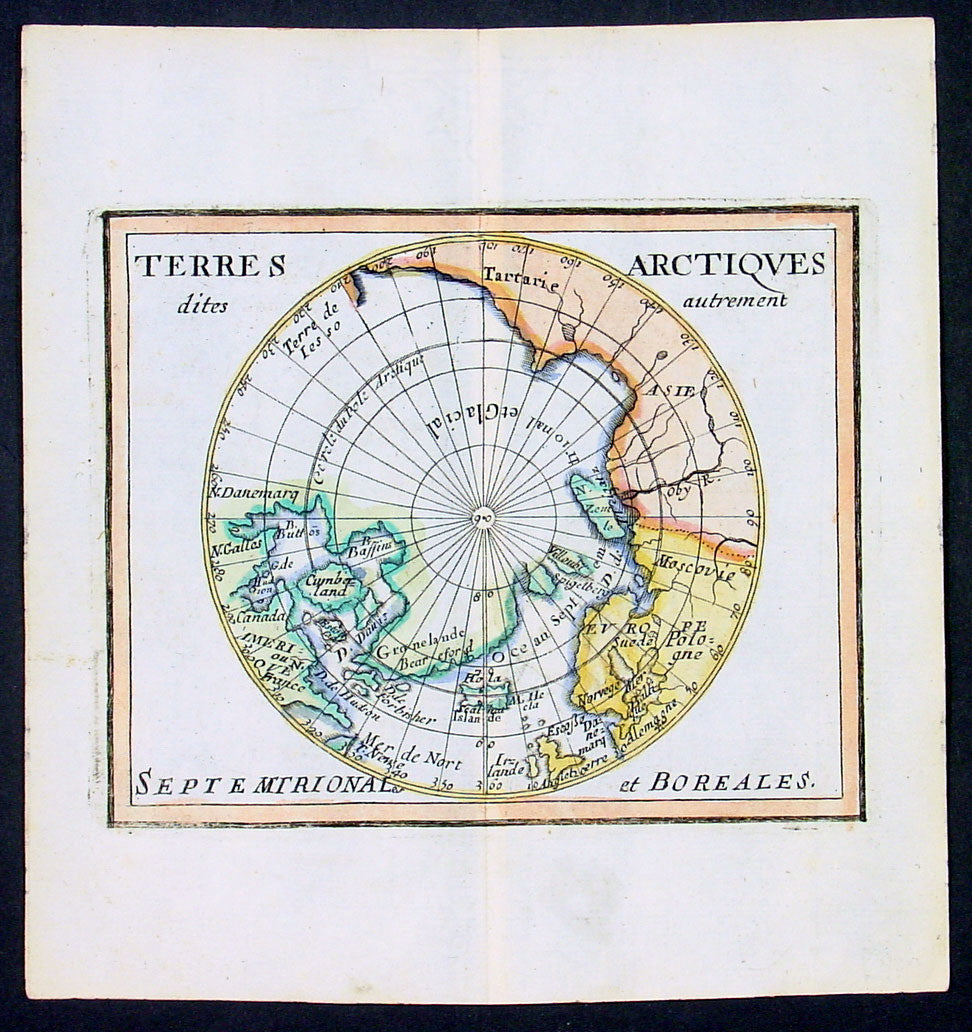
Description:This beautifully hand coloured original 1682 antique map of the North Pole by Pierre Du Val was published in his 1682 miniature atlas, 'Géographie Universelle'.Jacques Nicholas Bellindu
General Definitions:Paper thickness and quality: - Heavy and stablePaper color : - off whiteAge of map color: - OriginalColors used: - Yellow, green, blue, pinkGeneral color appearance: - AuthenticPaper size: - 6 1/2in x 6in (160mm x 155mm)Plate size: - 5in x 4in (125mm x 100mm)Margins: - Min 1/2in (12mm)
Imperfections:Margins: - NonePlate area: - NoneVerso: - None
Background: A driving force for the exploration of the Arctic was the desire of European monarchs to find an alternate trading route to China, via either a Northwest Passage along the coast of North America, or a Northeast Passage along the coast of Siberia. A number of expeditions sought such routes in the 1500-1700s, which resulted in the discovery of much of northern North America, but no viable passage. In 1524, under the direction of the king of France, Giovanni da Verrazano took the entrance to Hudson River (now New York City) to be the entrance for the passage, and ten years later Jacques Cartier likewise discovered the St. Lawrence estuary. The first Englishman to seek the passage was Martin Frobisher in three voyages up to 60°N between 1576 and 1578. On his first voyage, relations with the natives quickly became hostile, and a prisoner was brought back to England. John Davis followed in 1585, 1586, and 1587 charting the strait west of Greenland that now bears his name. Financed by the Dutch, in 1609 the Englishman Henry Hudson followed Verrazano's course, and explored the river that now bears his name. The following year he discovered the vast inlet (now called Hudson Bay) beyond Davis Strait. Robert Bylot and navigator William Baffin undertook two expeditions in 1615 and 1616, exploring the north coast of Greenland up to 78°N and then along the Canadian archipelago to Lancaster Sound. Convinced it was only a bay, Baffin concluded that no Northwest Passage existed, and interest in searching for one waned for the next 200 years. Other explorers were drawn to search for a Northeast Passage connecting the White Sea and Bering Sea. The Dutch navigator William Barents led three expeditions east of Novaya Zemlya, and on the third expedition in 1596 claimed Spitsbergen. From the early 16th century, Russian navigators used shallow draft vessels with reinforced bottoms (kochi) to cross the Kara Sea and explore the Ob and Yenisey rivers. Yermak's Cossacks expanded the Russian presence eastward, crossing the Ural Mountains in 1581. In 1601, Mangazeya town was founded at Taz River between the Ob and Yenisey rivers, and dozens of boats from Pomor lands began annual navigations. Throughout the first quarter of the 17th century, a great number of merchants, trappers and Cossacks moved east and north, settled East Siberia and explored the northern Siberian coast. In 1610, the Yenisey River was navigated to its northern estuary and the coast to the estuary of the Pyasina was explored. Cape Chelyuskin was overtaken from the west in 1617, Yakutian Cossacks Ivan Rebrov and Ilya Perfilyev headed down to the Lena River estuary and made the first sea voyage to the Yana River in 1633, and in 1639, the Pacific shore was reached by Ivan Moskvitin and his detachment of Cossacks. In a 15-year timespan, all Siberian river estuaries from Khatanga to Kolyma had been discovered and a large part of the Northeast Passage from the White Sea to Kolyma estuary had been covered. Semen Dezhnev traversed the final segment in 1648, leading 90 Cossacks on a journey from the Kolyma to Anadyr Rivers, discovering the strait between Asia and America (proving that they were different continents) and passing the cape which now bears his name.