Welcome to Classical Images!
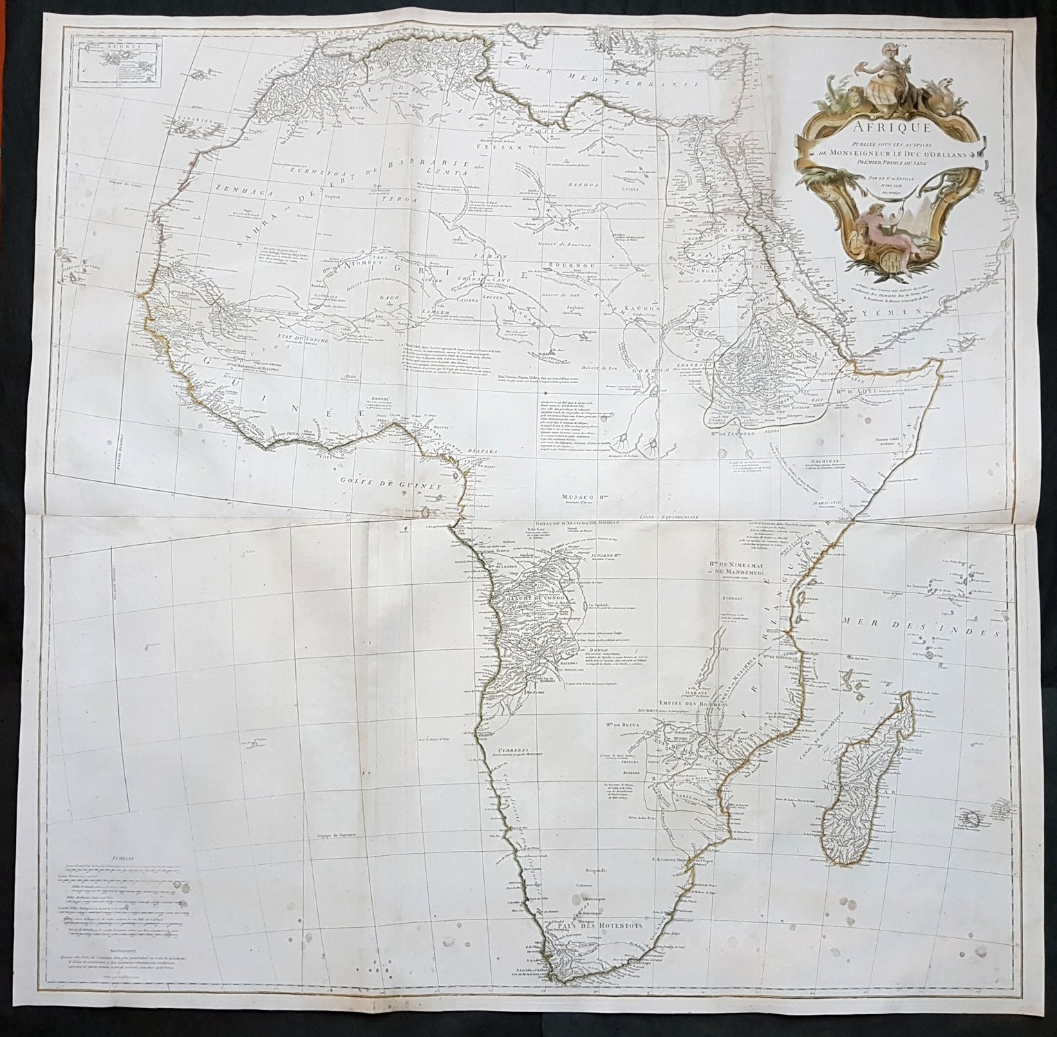
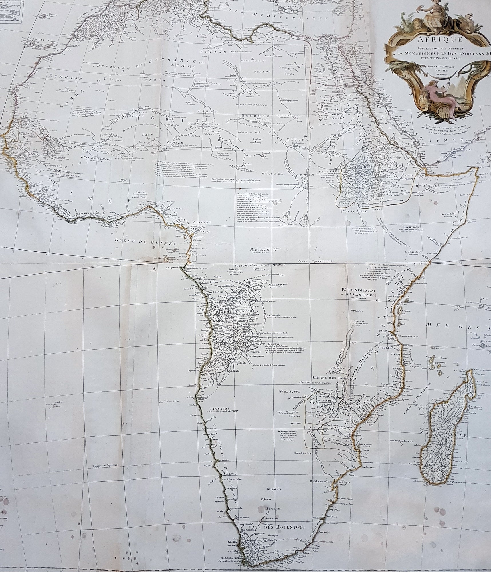
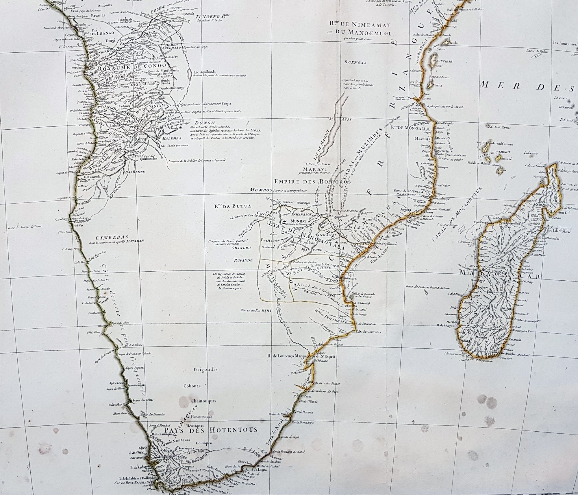
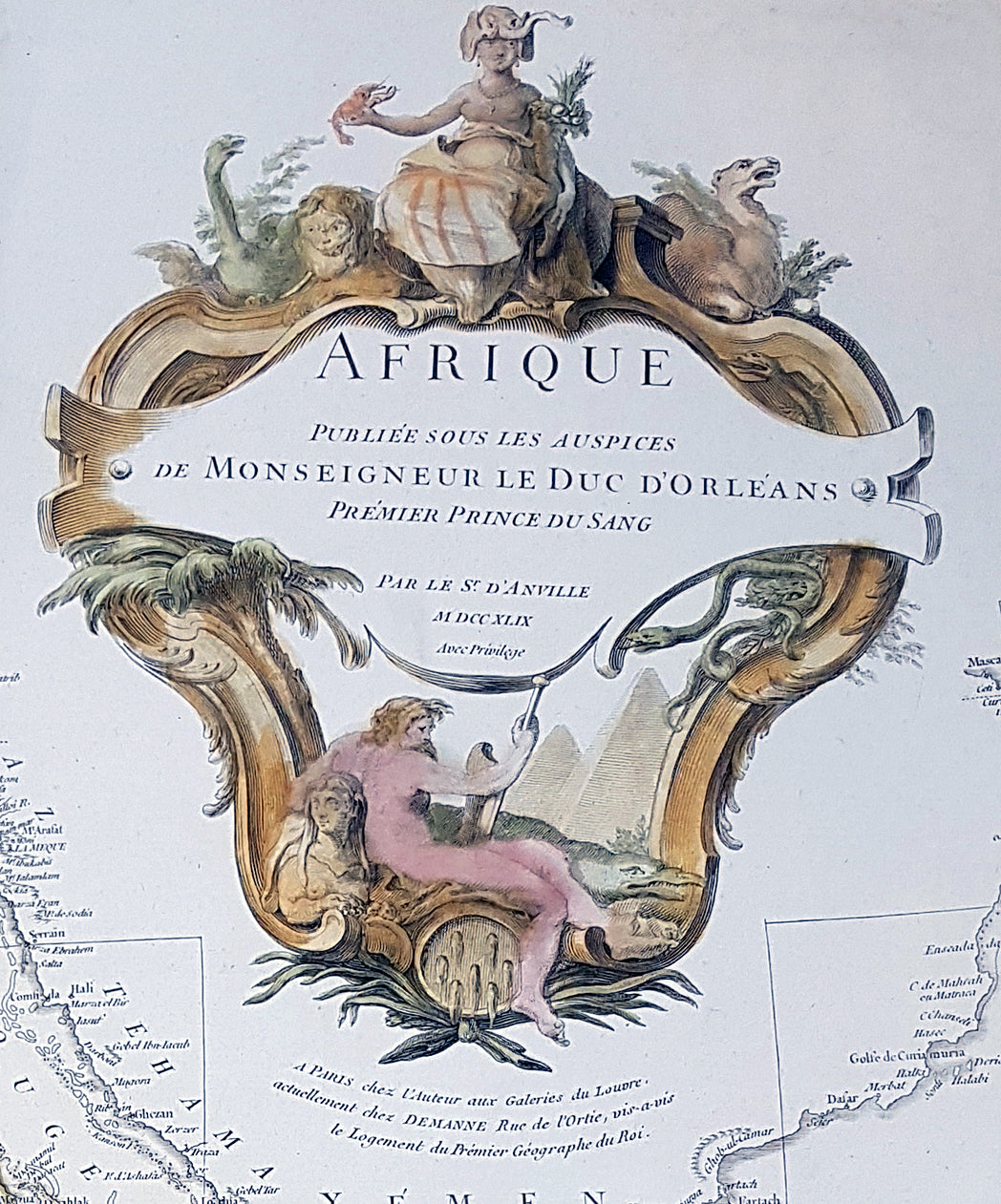
Description:This large finely engraved and highly detailed original antique map of Africa by Jean Baptiste Bourguignon D'Anville was engraved in 1759 - dated in the tile cartouche - by Guillaume Delahaye and was published D'Anville's large elephant folio Atlas Generale.This is one of the largest and most influential maps of Africa to appear in the mid-18th century. Anville\'s map covers the entire continent of Africa from the Mediterranean to the Cape of Good Hope and from the Cape Verde Islands to Madagascar. Anville was a careful cartographer known for his scientific approach to mapmaking, and nowhere is this more evident than in this, his greatest and most innovative map of Africa. Following the trajectory set by Guillaume de L\'Isle half a century earlier, D\'Anville takes a number of significant steps forward in addressing the confusions inherent in mapping this vast though mostly, in the mid-17th century, unexplored continent. These include unreliable cartographic suppositions regarding the African interior dating practically to antiquity. Many of these, including such speculative ideas as the \'Mountains of Kong,\' have been diminished if not removed entirely from this map, leaving vast unexplored areas throughout.What was known of Africa, however, Anville incorporates here in an impressive compilation of the most up to date reports from colonial, missionary, and exploratory entradas into the interior of the continent. Thus well mapped parts of the continent are limited to the Mediterranean Coast, Morocco, the Senegambia, the Congo, South Africa, the Kingdom of Monomatapa, Abyssinia, and egypt. Morocco, egypt, and the southern Mediterranean Coast (Barbary) were well known to europeans since antiquity and Anville\'s accurate mapping of these regions reflects continual contact. Further south the colonial enclaves along the Niger River (Senegal and Gambia), the Congo River, and South Africa reflect considerable detail associated with european penetration by trader and missionaries. The land of Monomopota around the Zambezi River was explored early in the 16th century by the Portuguese in hopes that the legendary gold mines supposedly found there would counterbalance the wealth flowing into Spain from the New Word. Unfortunately these mines, often associated with the Biblical kingdom of Ophir, were mostly tapped out by the 15th century. Abyssinia (modern day ethiopia) was mapped in detail by early Italian missionaries and of considerable interest to europeans first, because it was (and is) predominantly Christian; second, because it was a powerful well-organized and unified kingdom; and third because the sources of the Blue Nile were to be found here.The remainder of the continent remained largely speculative though Anville rarely lets his imagination get the upper hand. He does however follow the well-established Ptolemaic model laid down in the Geographica regarding the sources of the White Nile – here seen as two lakes at the base of the semi-apocryphal Mountains of the Moon. However, he also presents a curious network of interconnected rivers extending westward from the confused course of the White Nile following the popular 18th century speculation that the Nile may be connected to the Niger. To his credit Anville does not advocate this and offers no true commerce between the two river systems. Lake Malawi, here identified as Maravi, appears in a long thin embryonic state that, though it had not yet been \'discovered,\' is remarkably accurate to form. Lake Malawi was not officially discovered until Portuguese trader Candido Jose da Costa Cardoso stumbled upon it in 1849 – one hundred years following Anville\'s presentation of the lake here. Anville\'s inclusion of Lake Malawi is most likely a prescient interpretation of indigenous reports brought to europe by 17th century Portuguese traders. Its form would be followed by subsequent cartographers well into the mid-19th century when the explorations of John Hanning Speke, David Livingstone, Richard Francis Burton and others would at last yield a detailed study of Africa\'s interior.
General Definitions:Paper thickness and quality: - Heavy and stablePaper color : - off whiteAge of map color: - Original & laterColors used: - Yellow, green, blue, pinkGeneral color appearance: - AuthenticPaper size: - 40in x 40in (1.02m x 1.02m)Plate size: - 39in x 39in (1.0m x 1.0m)Margins: - Min 1/2in (12mm)
Imperfections:Margins: - NonePlate area: - Light spotting bottom of image, folds as issued, light toning along foldsVerso: - Light spotting bottom of image, folds as issued, light toning along folds
Background: Being part of the Mediterranean world, the northern coasts of the African continent as far as the Straits of Gibraltar and even round to the area of the Fortunate Isles (the Canaries) were reasonably well known and quite accurately mapped from ancient times. In particular, Egypt and the Nile Valley were well defined and the Nile itself was, of course, one of the rivers separating the continents in medieval T-O maps. Through Arab traders the shape of the east coast, down the Red Sea as far as the equator, was also known but detail shown in the interior faded into deserts with occasional mountain ranges and mythical rivers. The southern part of the continent, in the Ptolemaic tradition, was assumed to curve to the east to form a land-locked Indian Ocean. The voyages of the Portuguese, organized by Henry the Navigator in the fifteenth century, completely changed the picture and by the end of the century Vasco da Gama had rounded the Cape enabling cartographers to draw a quite presentable coastal outline of the whole continent, even if the interior was to remain largely unknown for the next two or three centuries.The first separately printed map of Africa (as with the other known continents) appeared in Munster\'s Geographia from 1540 onwards and the first atlas devoted to Africa only was published in 1588 in Venice by Livio Sanuto, but the finest individual map of the century was that engraved on 8 sheets by Gastaldi, published in Venice in 1564. Apart from maps in sixteenth-century atlases generally there were also magnificent marine maps of 1596 by Jan van Linschoten (engraved by van Langrens) of the southern half of the continent with highly imaginative and decorative detail in the interior. In the next century there were many attractive maps including those of Mercator/Hondius (1606), Speed (1627), Blaeu (1 630), Visscher (1636), de Wit (c. 1670), all embellished with vignettes of harbours and principal towns and bordered with elaborate and colourful figures of their inhabitants, but the interior remained uncharted with the exception of that part of the continent known as Ethiopia, the name which was applied to a wide area including present-day Abyssinia. Here the legends of Prester John lingered on and, as so often happened in other remote parts of the world, the only certain knowledge of the region was provided by Jesuit missionaries. Among these was Father Geronimo Lobo (1595-1678), whose work A Voyage to Abyssinia was used as the basis for a remarkably accurate map published by a German scholar, Hiob Ludolf in 1683. Despite the formidable problems which faced them, the French cartographers G. Delisle (c. 1700-22), J. B. B. d\'Anville (1727-49) and N. Bellin (1754) greatly improved the standards of mapping of the continent, improvements which were usually, although not always, maintained by Homann, Seutter, de Ia Rochette, Bowen, Faden and many others in the later years of the century. (Ref: Tooley; M&B)