Jean Baptiste Bourguignon D'Anville
1738 J B D Anville Antique Map of North Africa, Spain, Sardinia & Sicily
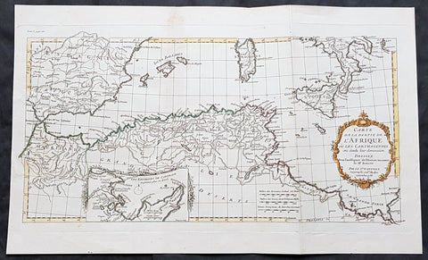
- Title : Carte de La Partie de L Afrique ou les Carthaginios de L Histoire Ancienne de Mr Rollin..Sr D Anville...1738
- Size: 20in x 12in (510mm x 303mm)
- Condition: (A+) Fine Condition
- Date : 1738
- Ref #: 70314
Description:
This magnificent original hand coloured copper-plate engraved antique map of North Africa, Spain, Sardinia & Sicily - with an inset plan of Carthage by Jean Baptiste Bourguignon D Anville in 1738 - dated - was published in Mr Charles Rollins Atlas. (Ref: M&B; Tooley)
General Definitions:
Paper thickness and quality: - Heavy and stable
Paper color : - off white
Age of map color: - Original
Colors used: - Blue, pink, red, green, yellow
General color appearance: - Authentic
Paper size: - 20in x 12in (510mm x 303mm)
Plate size: - 19 1/2in x 10 1/2in (495mm x 265mm)
Margins: - Min 1in (25mm)
Imperfections:
Margins: - None
Plate area: - None
Verso: - None
Background:
Being part of the Mediterranean world, the northern coasts of the African continent as far as the Straits of Gibraltar and even round to the area of the Fortunate Isles (the Canaries) were reasonably well known and quite accurately mapped from ancient times. In particular, Egypt and the Nile Valley were well defined and the Nile itself was, of course, one of the rivers separating the continents in medieval T-O maps. Through Arab traders the shape of the east coast, down the Red Sea as far as the equator, was also known but detail shown in the interior faded into deserts with occasional mountain ranges and mythical rivers. The southern part of the continent, in the Ptolemaic tradition, was assumed to curve to the east to form a land-locked Indian Ocean. The voyages of the Portuguese, organized by Henry the Navigator in the fifteenth century, completely changed the picture and by the end of the century Vasco da Gama had rounded the Cape enabling cartographers to draw a quite presentable coastal outline of the whole continent, even if the interior was to remain largely unknown for the next two or three centuries.
The first separately printed map of Africa (as with the other known continents) appeared in Munster\\\'s Geographia from 1540 onwards and the first atlas devoted to Africa only was published in 1588 in Venice by Livio Sanuto, but the finest individual map of the century was that engraved on 8 sheets by Gastaldi, published in Venice in 1564. Apart from maps in sixteenth-century atlases generally there were also magnificent marine maps of 1596 by Jan van Linschoten (engraved by van Langrens) of the southern half of the continent with highly imaginative and decorative detail in the interior. In the next century there were many attractive maps including those of Mercator/Hondius (1606), Speed (1627), Blaeu (1 630), Visscher (1636), de Wit (c. 1670), all embellished with vignettes of harbours and principal towns and bordered with elaborate and colourful figures of their inhabitants, but the interior remained uncharted with the exception of that part of the continent known as Ethiopia, the name which was applied to a wide area including present-day Abyssinia. Here the legends of Prester John lingered on and, as so often happened in other remote parts of the world, the only certain knowledge of the region was provided by Jesuit missionaries. Among these was Father Geronimo Lobo (1595-1678), whose work A Voyage to Abyssinia was used as the basis for a remarkably accurate map published by a German scholar, Hiob Ludolf in 1683. Despite the formidable problems which faced them, the French cartographers G. Delisle (c. 1700-22), J. B. B. d\\\'Anville (1727-49) and N. Bellin (1754) greatly improved the standards of mapping of the continent, improvements which were usually, although not always, maintained by Homann, Seutter, de Ia Rochette, Bowen, Faden and many others in the later years of the century.
1740 J B D Anville Antique Map Gulf Of The Black Sea, Turkey, Crimea & Armenia
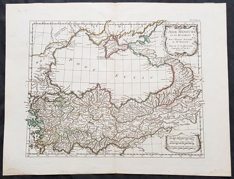
- Title : L Asie Mineure Et Le Bosphorepour L Histoire Ancienne de Mr Rollin...D Anville...1740
- Size: 16in x 13in (405mm x 330mm)
- Condition: (A+) Fine Condition
- Date : 1740
- Ref #: 70312
Description:
This magnificent original hand coloured copper-plate engraved antique map of The Black Sea, Turkey, Crimea & Armenia by Jean Baptiste Bourguignon D Anville in 1740 - dated - was published in Mr Charles Rollins Atlas. (Ref: M&B; Tooley)
General Definitions:
Paper thickness and quality: - Heavy and stable
Paper color : - off white
Age of map color: - Original
Colors used: - Blue, pink, red, green, yellow
General color appearance: - Authentic
Paper size: - 16in x 13in (405mm x 330mm)
Plate size: - 14in x 11 1/2in (355mm x 290mm)
Margins: - Min 1in (25mm)
Imperfections:
Margins: - None
Plate area: - None
Verso: - None
Background:
The Black Sea is a body of water and marginal sea of the Atlantic Ocean between Eastern Europe, the Caucasus, and Western Asia.[1] It is supplied by a number of major rivers, such as the Danube, Dnieper, Southern Bug, Dniester, Don, and the Rioni. About a third of Europe drains into the Black Sea,[2] including the countries of Austria, Belarus, Bosnia and Herzegovina, Bulgaria, Croatia, Georgia, Germany, Hungary, Moldova, Poland, Romania, Russia, Serbia, Slovakia, Slovenia, Turkey and Ukraine.
1743 D Anville & CA Coypel Large Antique Map of Italy, Sicily, Sardinia, Corsica
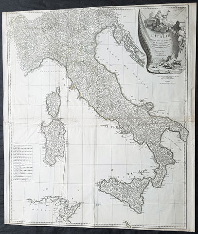
- Title : L Italie Publiee Sous Les Auspices De Monseigneur Le Duc D Orleans, Premier Prince Du Sang....Par L Sr D Anville...MDCCXLIII
- Date : 1743
- Condition: (A) Very Good Condition
- Ref: 92312
- Size: 32in x 28in (820mm x 710mm)
Description:
This large scarce original copper-plate engraved antique map of contemporary Italy, Sicily, Sardinia, Corsica & Malta by Charles-Antoine Coypel was engraved by Pierre-Alexandre Aveline (1702–1760) (both names engraved under cartouche) in 1743 - dated in cartouche - and was published by Jean-Baptiste Bourguinon D Anvilles in his large elephant folio atlas Atlas Generale.
A scarce and hard to find map with two famous names Charles-Antoine Coypel & Pierre-Alexandre Aveline engraved below the cartouche, I am assuming as both drawer & engraver.
General Definitions:
Paper thickness and quality: - Heavy and stable
Paper color : - off white
Age of map color: -
Colors used: -
General color appearance: -
Paper size: - 32in x 28in (820mm x 710mm)
Plate size: - 31 1/2in x 27in (810mm x 690mm)
Margins: - Min 1/8in (2mm)
Imperfections:
Margins: - Top margin cropped to border
Plate area: - Light creasing
Verso: - Creasing
Background:
Since classical times the countries bordering the enclosed waters of the Mediterranean had been well versed in the use of maps and sea charts and in Italy, more than anywhere else, the traditional knowledge was kept alive during the many hundreds of years following the collapse of the Roman Empire. By the thirteenth and fourteenth centuries the seamen of Venice, Genoa and Amalfi traded to far countries, from the Black Sea ports and the coasts of Palestine and Egypt in the East to Flanders and the southern coasts of England and Ireland in the West, their voyages guided by portulan charts and the use of the newly invented compass. For a time Italian supremacy in cartography passed to Aragon and the Catalan map makers based on Majorca, but by the year 1400 the power and wealth of the city states of Venice, Genoa, Florence and Milan surpassed any in Europe. Florence, especially, under the rule of the Medici family, became not only a great trading and financial centre but also the focal point of the rediscovery of the arts and learning of the ancient world. In this milieu a number of manuscript world maps were produced, of which one by Fra Mauro (c. 1459) is the most notable, but the event of the greatest importance in the history of cartography occurred in the year 1400 when a Florentine, Palla Strozzi, brought from Constantinople a Greek manuscript copy of Claudius Ptolemy\\\'s Geographia, which, 1,250 years after its compilation, came as a revelation to scholars in Western Europe. In the following fifty years or so manuscript copies, translated into Latin and other languages, became available in limited numbers but the invention of movable-type printing transformed the scene: the first copy without maps being printed in 1475 followed by many with copper-engraved maps, at Bologna in 1477, Rome 1478, 1490, 1507 and 1508, and Florence 1482.
About the year 1485 the first book of sea charts, compiled by Bartolommeo dalli Sonetti, was printed in Venice and in the first part of the sixteenth century a number of world maps were published, among them one compiled in 1506 by Giovanni Contarini, engraved by Francesco Rosselli, which was the first printed map to show the discoveries in the New World. In the following years there were many attractive and unusual maps of Islands (Isolano) by Bordone, Camocio and Porcacchi, but more important was the work of Giacomo (Jacopo) Gastaldi, a native of Piedmont who started life as an engineer in the service of the Venetian Republic before turning to cartography as a profession. His maps, produced in great variety and quantity, were beautifully drawn copperplate engravings and his style and techniques were widely copied by his contemporaries. From about 1550 to 1580 many of Gastaldi\\\'s maps appeared in the collections of maps known as Lafreri \\\'atlases\\\', a term applied to groups of maps by different cartographers brought together in one binding. As the contents of such collections varied considerably they were no doubt assembled at the special request of wealthy patrons and are now very rare indeed.
About this time, for a variety of historical and commercial reasons, Italy\\\'s position as the leading trading and financial nation rapidly declined and with it her superiority in cartography was lost to the vigorous new states in the Low Countries. That is not to say, of course, that Italian skills as map makers were lost entirely for it was not until 1620 that the first printed maps of Italy by an Italian, Giovanni Magini, appeared, and much later in the century there were fine maps by Giacomo de Rossi and Vincenzo Coronelli, the latter leading a revival of interest in cartography at the end of the century. Coronelli was also famous for the construction of magnificent large-size globes and for the foundation in Venice in 1680 of the first geographical society.
In the eighteenth century the best-known names are Antonio Zatta, Rizzi-Zannoni and Giovanni Cassini.
We ought to mention the work of Baptista Boazio who drew a series of maps in A Summarie and True Discourse of Sir Francis Drake\\\'s West Indian Voyage, published in 1588-89, and who is especially noted for a very fine map of Ireland printed in 1599 which was incorporated in the later editions of the Ortelius atlases. It is perhaps appropriate also to refer to two English map makers who spent many years in exile in Italy: the first, George Lily, famous for the splendid map of the British Isles issued in Rome in 1546, and the second, Robert Dudley, who exactly one hundred years later was responsible for the finest sea atlas of the day, Dell\\\' Arcano del Mare, published in Florence. Both of these are described in greater detail elsewhere in this handbook. (Ref: Tooley, Koeman)
1745 D Anville & Childs Antique Map of Senegal, Fort St Louis, African Slavary
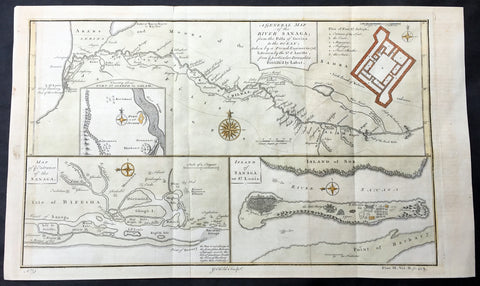
- Title : A General Map of The River Sanaga...Sr D Anville; A Map of the Entrance of the Sanaga; Island of Sanaga or St louis
- Date : 1745
- Size: 17 1/2in x 10in (440mm x 255mm)
- Ref #: 61152
- Condition: (A+) Fine Condition
Description:
This large hand coloured original copper-plate engraved antique map of Senegal and the Sanaga or Senegal River, along with a map of the entrance to the River and the Slave Island of Sanaga or St Louis after D Anville, by Graham Childs in 1745.
Background: These 3 maps are the key to a dark history of Slavery on the West Coast of Africa, in the country of Senegal. The first map shows the River of Senegal which would have been used to transport captured African slaves to the forts situated at the mouth of the river. These forts were used as holding stages for the captives, along with many others along the West African coast, prior to being transported to the Americas from the 16th to 18th centuries. (Ref: M&B; Tooley)
General Description:
Paper thickness and quality: - Heavy & stable
Paper color: - White
Age of map color: - Early
Colors used: - Yellow, pink, green
General color appearance: - Authentic
Paper size: - 17 1/2in x 10in (440mm x 255mm)
Plate size: - 15 1/2in x 9 1/2in (395mm x 240mm)
Margins: - Min 1/2in (12mm)
Imperfections:
Margins: - None
Plate area: - Folds as issued
Verso: - None
1746 J B D Anville Large Antique Map of North America
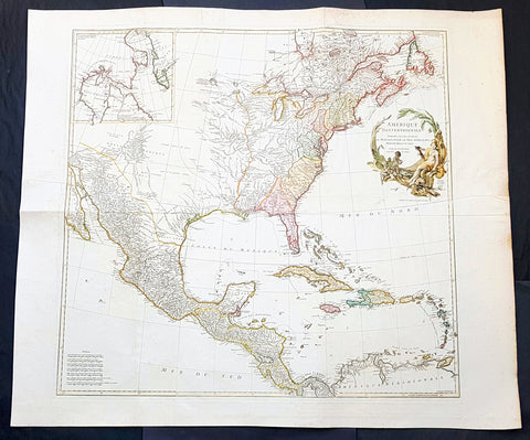
- Title : Amerique Septentrionale Publiee sous les Auspices de Monseigneur le Duc d 'Orleans.. Par Le Snr. D Anville MDCCXLVI
- Date : 1746
- Condition: (A+) Fine Condition
- Ref: 93207
- Size: 42 1/2in x 37in (1.08m x 940mm)
Description:
This spectacular large original copper plate engraved antique map of North America by Jean-Baptiste Bourguinon D Anville was in 1746 - dated - and was published in his elphant folio Atlas Generale.
General Definitions:
Paper thickness and quality: - Heavy and stable
Paper color : - off white
Age of map color: - Original & later
Colors used: - Blue, pink, red, green, yellow
General color appearance: - Authentic
Paper size: - 42 1/2in x 37in (1.08m x 940mm)
Plate size: - 34 1/2in x 33 1/2in (875m x 850mm)
Margins: - Min 2in (50mm)
Imperfections:
Margins: - Light spotting in margins
Plate area: - Folds as issued
Verso: - Folds as issued
Background:
To illustrate the cartography of the mid eighteenth century, especially American cartography, a D Anville map is essential. He dominated not only the French but all contemporary European cartography. He was foremost to leave blank spaces in his maps where knowledge was insufficient. His representation of the great lakes is superior to that of his contemporary John Mitchell who was responsible for publishing one of the most famous mid 18th century maps A Map of the British and French Dominions in North America on 8 sheets London in 1755. It was the standard map of North America up until the end of the century.
Eusebio Francisco Kinos discoveries of California in the beginning of the 18th century have now made full impact. D Anvilles map shows California as a peninsula and the Colorado and Gila Rivers are more accurately located. Note that the western part of the Gila River is named the Rio Grande, the Santa Cruz River is called Sta. Maria, and the San Pedro River is Terenate. (Ref: Tooley, Printed maps of America, 104; The Mapping of America 316)
1746 J B D Anville Large Rare Antique Map of North America Pre French Indian War
-
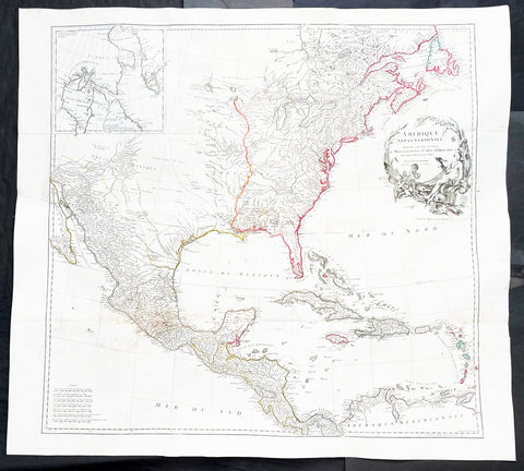
Title : Amerique Septentrionale Publiee sous les Auspices de Monseigneur le Duc d Orleans.. Par Le Snr. D Anville MDCCXLVI
- Ref #: 17010
-
Condition: (A+) Fine Condition
- Size: 42 1/2in x 37in (1.08m x 940mm)
- Date : 1746
Description:
This large important original copper plate engraved antique map of North America, in 12 sheets joined, was engraved in 1746 - dated in the cartouche - and was published by Jean-Baptiste Bourguinon D Anville in his Elephant Folio Atlas Generale.
This map was instrumental in instructing the European Colonial powers of the time, England France & Spain the importance of dominating the New World, that ultimately led to the French and Indian War of 1754–63. This conflict determined the political direction of North America leading to the American War of Independence in 1775 and ultimately the formation of The United States of America.
To illustrate the importance of cartography in the mid eighteenth century, especially that of North America, a J B D Anville map is essential. D Anville dominated 18th century European cartography with many of his cartographical achievements, especially in North America, copied by many of his contemporaries such as Kitchen, Sayer, Homann, Seutter, Mitchell and others .
He was one of the first to leave blank spaces in his maps, where knowledge was scant or insufficient. His representation of the great lakes is superior to that of his contemporary John Mitchell, responsible for publishing one of the most famous mid 18th century maps of North America, A Map of the British and French Dominions in North America on 8 sheets in 1755 and remained the standard map of North America up until the end of the 18th century. (Ref: Tooley, Printed maps of America, 104; The Mapping of America 316)
General Definitions:
Paper thickness and quality: - Heavy and stable
Paper color : - off white
Age of map color: - Original
Colors used: - Red, yellow, green, blue
General color appearance: - Authentic
Paper size: - 42 1/2in x 37in (1.08m x 940mm)
Plate size: - 34 1/2in x 33 1/2in (875m x 850mm)
Margins: - Min 1in (25mm)
Imperfections:
Margins: - Small wormholes in left margin repaired, not affecting the image
Plate area: - Light age toning
Verso: - Age toning
Background:
The French and Indian War (1754–63) comprised the North American theatre of the worldwide Seven Years War of 1756–63. It pitted the colonies of British America against those of New France. Both sides were supported by military units from their parent countries, as well as by American Indian allies. At the start of the war, the French North American colonies had a population of roughly 60,000 settlers, compared with 2 million in the British North American colonies. The outnumbered French particularly depended on the Indians. The European nations declared war on one another in 1756 following months of localized conflict, escalating the war from a regional affair into an intercontinental conflict.
The name French and Indian War is used mainly in the United States. It refers to the two enemies of the British colonists, the royal French forces and their various American Indian allies. The British colonists were supported at various times by the Iroquois, Catawba, and Cherokee, and the French colonists were supported by Wabanaki Confederacy members Abenaki and Mikmaq, and Algonquin, Lenape, Ojibwa, Ottawa, Shawnee, and Wyandot.
British and other European historians use the term the Seven Years War, as do English-speaking Canadians. French Canadians call it La guerre de la Conquête (the War of the Conquest) or (rarely) the Fourth Intercolonial War.
Fighting took place primarily along the frontiers between New France and the British colonies, from Virginia in the south to Newfoundland in the north. It began with a dispute over control of the confluence of the Allegheny River and Monongahela River called the Forks of the Ohio, and the site of the French Fort Duquesne in Pittsburgh, Pennsylvania. The dispute erupted into violence in the Battle of Jumonville Glen in May 1754, during which Virginia militiamen under the command of 22-year-old George Washington ambushed a French patrol.
In 1755, six colonial governors in North America met with General Edward Braddock, the newly arrived British Army commander, and planned a four-way attack on the French. None succeeded, and the main effort by Braddock proved a disaster; he lost the Battle of the Monongahela on July 9, 1755 and died a few days later. British operations failed in the frontier areas of Pennsylvania and New York during 1755–57 due to a combination of poor management, internal divisions, effective Canadian scouts, French regular forces, and Indian warrior allies. In 1755, the British captured Fort Beauséjour on the border separating Nova Scotia from Acadia, and they ordered the expulsion of the Acadians (1755–64) soon afterwards. Orders for the deportation were given by William Shirley, Commander-in-Chief, North America, without direction from Great Britain. The Acadians were expelled, both those captured in arms and those who had sworn the loyalty oath to His Britannic Majesty. Indians likewise were driven off the land to make way for settlers from New England.
The British colonial government fell in the region of modern Nova Scotia after several disastrous campaigns in 1757, including a failed expedition against Louisbourg and the Siege of Fort William Henry; this last was followed by Indians torturing and massacring their British victims. William Pitt came to power and significantly increased British military resources in the colonies at a time when France was unwilling to risk large convoys to aid the limited forces that they had in New France, preferring to concentrate their forces against Prussia and its allies in the European theater of the war. Between 1758 and 1760, the British military launched a campaign to capture the Colony of Canada (part of New France). They succeeded in capturing territory in surrounding colonies and ultimately the city of Quebec (1759). The British later lost the Battle of Sainte-Foy west of Quebec (1760), but the French ceded Canada in accordance with the Treaty of Paris (1763).
The outcome was one of the most significant developments in a century of Anglo-French conflict. France ceded to Great Britain its territory east of the Mississippi. It ceded French Louisiana west of the Mississippi River (including New Orleans) to its ally Spain in compensation for Spains loss to Britain of Florida. (Spain had ceded Florida to Britain in exchange for the return of Havana, Cuba.) Frances colonial presence north of the Caribbean was reduced to the islands of Saint Pierre and Miquelon, confirming Great Britains position as the dominant colonial power in eastern North America.
Please note all items auctioned are genuine, we do not sell reproductions. A Certificate of Authenticity (COA) can be issued on request.
1751 D Anville Large Antique Map of West Asia - Saudi Arabia, Persia & India
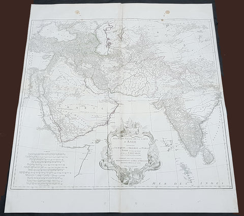
- Title : Premiere Partie de la Carte D Asie contrnant La Turquie, L Arabie, La Perse, L Inde...Sr D Anville...MDCCLI
- Size: 35 1/2in x 31 1/2in (900mm x 800mm)
- Condition: (A+) Fine Condition
- Date : 1751
- Ref #: 92314
Description:
This large original copper plate engraved antique map of West Asia from Saudi Arabia, Persia and India was engraved in 1751 - dated in the tile cartouche - and was published in Jean-Baptiste Bourguinon D Anvilles large elephant folio atlas Atlas Generale.
General Definitions:
Paper thickness and quality: - Heavy and stable
Paper color : - off white
Age of map color: - Original
Colors used: - Red
General color appearance: - Authentic
Paper size: - 35 1/2in x 31 1/2in (900mm x 800mm)
Plate size: - 31 1/2in x 29 1/2in (810mm x 750mm)
Margins: - Min 1/2in (12mm)
Imperfections:
Margins: - Two tan spots in top margin into border
Plate area: - Light creasing
Verso: - Light soiling
1751 D Anville Very Large Antique Map The West Coast of Africa, Gambia & Senegal
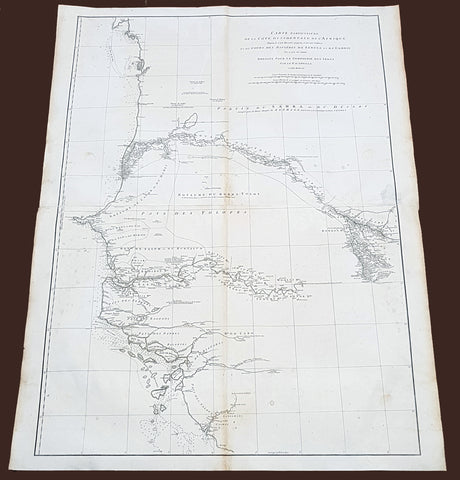
- Title : Carte Particuliere De La Cote Occidentale De L'Afrique Depusi le Cap Blanc jusqu'au Cap De Verga et du Cours Des Rivieres De Senega et de Gambie . .MDCCLI
- Ref #: 92324
- Size: 42in x 33in (1.07m x 840mm)
- Date : 1751
- Condition: (A) Very Good Condition
Description:
This very large finely engraved, highly detailed original antique map of of the west coast of Africa covering Gambia and Senegal was engraved in 1751 - dated in the tile cartouche - and was published in Jean-Baptiste Bourguinon D'Anville's large elephant folio atlas Atlas Generale.
Description: D' Anville's maps have a clarity and a directness that is very 'modern'. He incorporated as much known information into his maps as he could. Map extent is from Cap Blanc in the north to Cap de Verga in the south.
Being part of the Mediterranean world, the northern coasts of the African continent as far as the Straits of Gibraltar and even round to the area of the Fortunate Isles (the Canaries) were reasonably well known and quite accurately mapped from ancient times. In particular, Egypt and the Nile Valley were well defined and the Nile itself was, of course, one of the rivers separating the continents in medieval T-O maps. Through Arab traders the shape of the east coast, down the Red Sea as far as the equator, was also known but detail shown in the interior faded into deserts with occasional mountain ranges and mythical rivers. The southern part of the continent, in the Ptolemaic tradition, was assumed to curve to the east to form a land-locked Indian Ocean. The voyages of the Portuguese, organized by Henry the Navigator in the fifteenth century, completely changed the picture and by the end of the century Vasco da Gama had rounded the Cape enabling cartographers to draw a quite presentable coastal outline of the whole continent, even if the interior was to remain largely unknown for the next two or three centuries.
The first separately printed map of Africa (as with the other known continents) appeared in Munster's Geographia from 1540 onwards and the first atlas devoted to Africa only was published in 1588 in Venice by Livio Sanuto, but the finest individual map of the century was that engraved on 8 sheets by Gastaldi, published in Venice in 1564. Apart from maps in sixteenth-century atlases generally there were also magnificent marine maps of 1596 by Jan van Linschoten (engraved by van Langrens) of the southern half of the continent with highly imaginative and decorative detail in the interior. In the next century there were many attractive maps including those of Mercator/Hondius (1606), Speed (1627), Blaeu (1 630), Visscher (1636), de Wit (c. 1670), all embellished with vignettes of harbours and principal towns and bordered with elaborate and colourful figures of their inhabitants, but the interior remained uncharted with the exception of that part of the continent known as Ethiopia, the name which was applied to a wide area including present-day Abyssinia. Here the legends of Prester John lingered on and, as so often happened in other remote parts of the world, the only certain knowledge of the region was provided by Jesuit missionaries. Among these was Father Geronimo Lobo (1595-1678), whose work A Voyage to Abyssinia was used as the basis for a remarkably accurate map published by a German scholar, Hiob Ludolf in 1683. Despite the formidable problems which faced them, the French cartographers G. Delisle (c. 1700-22), J. B. B. d'Anville (1727-49) and N. Bellin (1754) greatly improved the standards of mapping of the continent, improvements which were usually, although not always, maintained by Homann, Seutter, de Ia Rochette, Bowen, Faden and many others in the later years of the century. (Ref: Tooley, M&B)
General Description:
Paper thickness and quality: - Heavy and stable
Paper color: - White
Age of map color: -
Colors used: -
General color appearance: -
Paper size: - 42in x 33in (1.07m x 840mm)
Plate size: - 40 1/2in x 28in (1.02m x 710mm)
Margins: - Min 1in (25mm)
Imperfections:
Margins: - Light soiling
Plate area: - Light soiling
Verso: - Light soiling

1751 D Anville Very Large Antique Map The West Coast of Africa, Slave Coast
- Title : Carte Particuliere De La Cote Occidentale De L'Afrique Depusi le Cap Blanc jusqu'au Cap De Verga et du Cours Des Rivieres De Senega et de Gambie . .MDCCLI
- Ref #: 22009
- Size: 42in x 33in (1.07m x 840mm)
- Date : 1751
- Condition: (A+) Fine Condition
Description:
This very large finely engraved, highly detailed original antique map of of the west coast of Africa covering Gambia and Senegal was engraved in 1751 - dated in the tile cartouche - and was published in Jean-Baptiste Bourguinon D'Anville's large elephant folio atlas Atlas Generale.
Description: D' Anville's maps have a clarity and a directness that is very 'modern'. He incorporated as much known information into his maps as he could. Map extent is from Cap Blanc in the north to Cap de Verga in the south.
Being part of the Mediterranean world, the northern coasts of the African continent as far as the Straits of Gibraltar and even round to the area of the Fortunate Isles (the Canaries) were reasonably well known and quite accurately mapped from ancient times. In particular, Egypt and the Nile Valley were well defined and the Nile itself was, of course, one of the rivers separating the continents in medieval T-O maps. Through Arab traders the shape of the east coast, down the Red Sea as far as the equator, was also known but detail shown in the interior faded into deserts with occasional mountain ranges and mythical rivers. The southern part of the continent, in the Ptolemaic tradition, was assumed to curve to the east to form a land-locked Indian Ocean. The voyages of the Portuguese, organized by Henry the Navigator in the fifteenth century, completely changed the picture and by the end of the century Vasco da Gama had rounded the Cape enabling cartographers to draw a quite presentable coastal outline of the whole continent, even if the interior was to remain largely unknown for the next two or three centuries.
The first separately printed map of Africa (as with the other known continents) appeared in Munster's Geographia from 1540 onwards and the first atlas devoted to Africa only was published in 1588 in Venice by Livio Sanuto, but the finest individual map of the century was that engraved on 8 sheets by Gastaldi, published in Venice in 1564. Apart from maps in sixteenth-century atlases generally there were also magnificent marine maps of 1596 by Jan van Linschoten (engraved by van Langrens) of the southern half of the continent with highly imaginative and decorative detail in the interior. In the next century there were many attractive maps including those of Mercator/Hondius (1606), Speed (1627), Blaeu (1 630), Visscher (1636), de Wit (c. 1670), all embellished with vignettes of harbours and principal towns and bordered with elaborate and colourful figures of their inhabitants, but the interior remained uncharted with the exception of that part of the continent known as Ethiopia, the name which was applied to a wide area including present-day Abyssinia. Here the legends of Prester John lingered on and, as so often happened in other remote parts of the world, the only certain knowledge of the region was provided by Jesuit missionaries. Among these was Father Geronimo Lobo (1595-1678), whose work A Voyage to Abyssinia was used as the basis for a remarkably accurate map published by a German scholar, Hiob Ludolf in 1683. Despite the formidable problems which faced them, the French cartographers G. Delisle (c. 1700-22), J. B. B. d'Anville (1727-49) and N. Bellin (1754) greatly improved the standards of mapping of the continent, improvements which were usually, although not always, maintained by Homann, Seutter, de Ia Rochette, Bowen, Faden and many others in the later years of the century. (Ref: Tooley, M&B)
General Description:
Paper thickness and quality: - Heavy and stable
Paper color: - White
Age of map color: -
Colors used: -
General color appearance: -
Paper size: - 42in x 33in (1.07m x 840mm)
Plate size: - 40 1/2in x 28in (1.02m x 710mm)
Margins: - Min 1in (25mm)
Imperfections:
Margins: - None
Plate area: - Light text offsetting
Verso: - None
1752 D Anville Large Antique Map of Louisiana, New Orleans, Gulf Coast, America
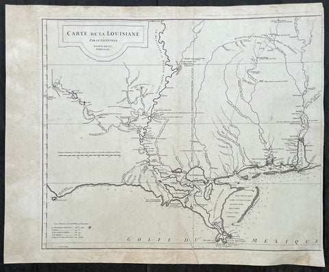
- Title : Carte de La Louisiane Par le Sr D Anville Dressee Mai 1732. Publiee en 1752
- Ref #: 17025
- Size: 26in x 23in (710mm x 580mm)
- Date : 1752
- Condition: (A) Very Good Condition
Description:
This large original copper-plate engraved antique left sheet of the map of Louisiana and the Gulf Coast was first engraved in 1732 with updates to 1752 by Guillaume Nicolas Delahaye (1727 - 1802) - the dates are engraved in the title - and was published by Jean-Baptiste Bourguinon D Anville's in his large elephant folio atlas Atlas Generale.
NB - I have included an image of the map joined.
General Definitions:
Paper thickness and quality: - Heavy and stable
Paper color : - off white
Age of map color: -
Colors used: -
General color appearance: -
Paper size: - 26in x 23in (710mm x 580mm)
Plate size: - 24 3/4in x 20 3/4in (630mm x 530mm)
Margins: - Min 1/8in (3mm)
Imperfections:
Margins: - Light age toning and creasing in margins
Plate area: - Light age toning
Verso: - Small archival tape strips on verso
Background:
An uncommon, historically important and influential map of US South coast, stretching from the Gulf of Mobile to the mouth of the Sabine in Texas, centering on New Orleans and the surrounding area. It is one of the earliest and most detailed large format maps of the region, depicting early French settlements of the Gulf Coast region.
The map tracks the Mississippi, Arkansas, Red, Osage and Missouri Rivers.
It is known that Thomas Jefferson acquired 7 of D Anvilles maps in 1787, almost certainly, this was one of them. Jefferson commented to Gallatin about the importance of this map. Meriwether Lewis obtained a copy prior to the Lewis & Clark Expedition.
It is also know that most of the information for this map is derived from Valentin Devin, who arrived in Pensacola in 1719 and began producing highly detailed maps immediately upon his arrival on the Gulf Coast, until expelled by the Spanish after a three year struggle. Devin used his information and materials gathered from Le Maire and others to produce a number of manuscript maps which were sent back to France and resulted in a series of marvellous maps by De L'Isle, Buache and finally D'Anville, whose maps of the Gulf Coast formed the standard for a number of years.
To illustrate the cartography of the middle to latter part of the eighteenth century - especially detail of America & the Southern Hemisphere - a D' Anville map is essential. He dominated not only the French but all contemporary geographers, regardless of nationality.
He was foremost in using the latest and most accurate cartographic information from the latest discoveries of French explorers of the day but also from Cook and others. And unlike many cartographers of the day he was not adverse to leave blank spaces in his maps where knowledge was insufficient.
Please note all items auctioned are genuine, we do not sell reproductions. A Certificate of Authenticity (COA) can be issued on request.
1752 D Anville Large Original Antique Map of India Sri Lanka Burma Siam - Scarce
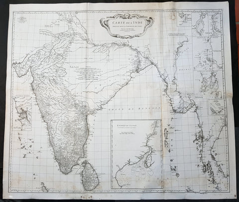
- Title : Carte De L Inde Dressee Pour La Compagnie Des Indes...1752
- Size: 43in x 37 1/2in (1.1m x 950mm)
- Ref #: 92320
- Date : 1752
- Condition: (A) Very Good Condition
Description:
This large finely engraved scarce and highly detailed original antique map of India, Sri Lanka Burma & Thailand was engraved by Guillaume de la Haye in 1752 - dated in the tile cartouche - and was published in Jean-Baptiste Bourguinon D\'Anville\'s large elephant folio atlas Atlas Generale.
General Definitions:
Paper thickness and quality: - Heavy and stable
Paper color : - off white
Age of map color: -
Colors used: -
General color appearance: -
Paper size: - 43in x 37 1/2in (1.1m x 950mm)
Plate size: - 41in x 35in (1.04m x 890mm)
Margins: - Min 1in (25mm)
Imperfections:
Margins: - Spotting
Plate area: - Spotting, aging toning along folds as issued
Verso: - Spotting, aging toning along folds as issued
Background:
The map is drawn from numerous sources, including Ptolemy, Turkish and Indian geographies, and Jesuit surveys. More contemporary works by Bouchet in 1719 and Boudier in 1734 are seen both in the detail and inset river maps. The map reflects the level of knowledge of India & SE Asia at the time, especially of the interiors. The map has excellent detail of Southern India and coastlines were trade had been happening for centuries, but a conspicuous absence of detail of the northern interior
There are seven Inset maps that include the environs of Goa, entrance of the Ganges River and a wonderfully detailed depiction of the entrance to the Hugli River and other river tributes.
1753 D Anville Large Original Antique Map of SE Coromandel Coast of India - Rare
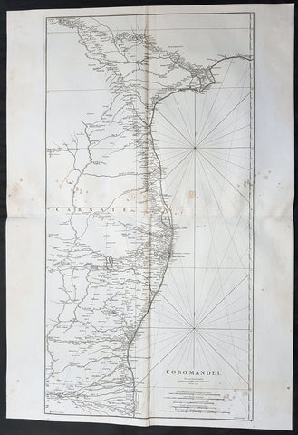
- Title : Coromandel par Le Sr D Anville...1753
- Size: 39 1/2in x 27in (1.1m x 685mm)
- Ref #: 92321
- Date : 1753
- Condition: (A) Very Good Condition
Description:
This large finely engraved scarce and highly detailed original antique map of South East Coast of India, the Coromandel Coast was engraved by Guillaume de la Haye in 1753 - dated in the tile cartouche - and was published in Jean-Baptiste Bourguinon D\'Anville\'s large elephant folio atlas Atlas Generale.
General Definitions:
Paper thickness and quality: - Heavy and stable
Paper color : - off white
Age of map color: -
Colors used: -
General color appearance: -
Paper size: - 39 1/2in x 27in (1.1m x 685mm)
Plate size: - 38in x 19 1/2in (970mm x 495mm)
Margins: - Min 1/2in (12mm)
Imperfections:
Margins: - Light spotting to right of image
Plate area: - Light spotting to right of image
Verso: - Light spotting to right of image
Background:
The Coromandel Coast is the southeastern coast region of the Indian Subcontinent, between the Eastern Ghats and the Bay of Bengal of the Indian Ocean. The coastline runs between False Divi Point in the north to Kanyakumari in the south. Its definition can also include the northwestern coast of the island of Sri Lanka.
By late 1530 the Coromandel Coast was home to three Portuguese settlements at Nagapattinam, São Tomé de Meliapore, and Pulicat. Later, in the 17th and 18th centuries, the Coromandel Coast was the scene of rivalries among European powers for control of the India trade. The British established themselves at Fort St George (Madras) and Masulipatnam, the Dutch at Pulicat, Sadras and Covelong, the French at Pondicherry, Karaikal and Nizampatnam, the Danish in Dansborg at Tharangambadi.
The Coromandel Coast supplied Indian Muslim eunuchs to the Thai palace and court of Siam (modern Thailand). The Thai at times asked eunuchs from China to visit the court in Thailand and advise them on court ritual since they held them in high regard.
Eventually the British won out, although France retained the tiny enclaves of Pondichéry and Karaikal until 1954. Chinese lacquer goods, including boxes, screens, and chests, became known as \"Coromandel\" goods in the eighteenth century, because many Chinese exports were consolidated at the Coromandel ports.
1754 D Anville Large Antique Map of The Caspian Sea
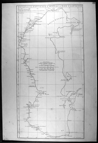
- Title : Essai D Une Nouvelle Carte de la Mer Caspienne...November 1754
- Ref #: 92317
- Size: 21 1/2in x 14 1/2in (550mm x 370mm)
- Date : 1754
- Condition: (A+) Fine Condition
Description:
This large original antique map of of the Caspian Sea by Jean Baptiste Bourguignon D'Anville was engraved in 1754 - dated - and was published in D Anville's large elephant folio Atlas Generale. (Ref: M&B; Tooley)
General Description:
Paper thickness and quality: - Heavy and stable
Paper color: - off white
Age of map color: -
Colors used: -
General color appearance: -
Paper size: - 21 1/2in x 14 1/2in (550mm x 370mm)
Plate size: - 20 3/4in x 10 1/2in (525mm x 270mm)
Margins: - Min 1/2in (12mm)
Imperfections:
Margins: - None
Plate area: - Two very small worm holes bottom left
Verso: - None
1754 D Anville Large Original Antique Map of Western Europe British Isles - Rare
- Title : Premiere Partie De La Carte D Europe...MDCCLIV
- Size: 39 1/2in x 33in (1.03m x 840mm)
- Ref #: 92307
- Date : 1754
- Condition: (A+) Fine Condition
Description:
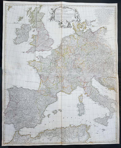
This large finely engraved scarce and highly detailed original antique map of contemporary Western Europe and the British Isles was engraved by Guillaume de la Haye in 1754 - dated in the tile cartouche - and was published in Jean-Baptiste Bourguinon D\'Anville\'s large elephant folio atlas Atlas Generale.
General Definitions:
Paper thickness and quality: - Heavy and stable
Paper color : - off white
Age of map color: - Original
Colors used: - Pink, yellow, green, blue
General color appearance: - Authentic
Paper size: - 39 1/2in x 33in (1.03m x 840mm)
Plate size: - 38in x 32in (970mm x 815mm)
Margins: - Min 1/2in (12mm)
Imperfections:
Margins: - None
Plate area: - Light spotting, folds as issued
Verso: - Light spotting, folds as issued
Background:
Fantastic historical map showing the fragmented political borders,hand coloured, of Western Europe in the mid 18th century from Poland to France and North Africa, including the British Isles.
1755 D Anville & Bolton Large Antique Map of Asia, Turkey, Saudi Arabia, India
- Title : First Part of Asia being Turkey, Arabia, Persia most of India and Tartary Performed by the Sr D Anville...Revised and Improved by Mr Bolton MDCCLV (1755)
- Size: 31 1/2in x 30in (800mm x 765mm)
- Condition: (A) Very Good Condition
- Date : 1755
- Ref #: 91298
Description:
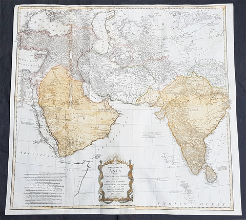
This large original hand coloured, copper plate engraved antique map of western Asia from Turkey to Saudi Arabia to India by Solomon Bolton, after the French cartographer Jean Baptiste Bourguignon D Anville, was engraved in 1755 - dated - and published in the 1765 edition of Malachy Postlethweyts monumental 2 Volume tomes on The Universal Dictionary of Trade & Commerce concentrating on various states of trade, including slavery, between England and America published between 1751 & 1774.
General Definitions:
Paper thickness and quality: - Heavy and stable
Paper color : - off white
Age of map color: - Early
Colors used: - Yellow, green, blue, pink
General color appearance: - Authentic
Paper size: - 31 1/2in x 30in (800mm x 765mm)
Plate size: - 31 1/2in x 30in (800mm x 765mm)
Margins: - Min 1/2in (10mm)
Imperfections:
Margins: - Top margin extended from plate mark
Plate area: - Folds as issued, small restoration to left fold
Verso: - Folds as issued
Background:
Postlethweyt, Malachy 1707 – 1767
Malachy Postlethweyts Dictionary of Trade & Commerce: A monumental dictionary of trade and commerce. It is based in part on the Dictionnaire universel de Commerce (Paris: 1723-30) of Jacques Savary de Bruslon, under whose name it is often catalogued, but has been adapted by Postlethwayt for a British audience, with substantial enlargements and improvements, and entirely new material relating to England and her colonies. Postlethwayt devoted twenty years to the preparation of the dictionary, which was first published in 1751-55 & includes a description of British affairs in North America since the peace of 1763.
As with his other works, the dictionary demonstrates Postlethway’s deep commitment to the expansion and strengthening of English trade. Included are entries for geographical locations (Africa, Antilles, Canada, Japan, Louisiana, &c.), products (brandy, cardamom, codfish, diamonds, sugar, &c.), trading companies (Dutch East India Company, English African Company, &c.), treaties of commerce, and a vast range of other information of value to merchants (bankruptcy, currency, bills of exchange, brokerage, exportation, landed interest, privateering, &c.). The Dictionary is also important for containing almost the whole substance of Richard Cantillon’s Essay on Commerce, its first appearance in print.
1755 D Anville Large Old, Antique Map of North America, Great Lakes, Indian Wars
- Title : Canada Louisiane et Terres Anglois Par Le Sr. D Anville...MDCCLV
- Ref #: 61106
- Size: 46 1/2in x 35 3/4in (1.17m x 910mm)
- Date : 1755
- Condition: (A+) Fine Condition
Description:
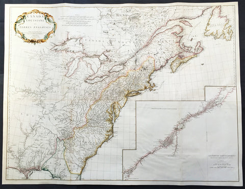
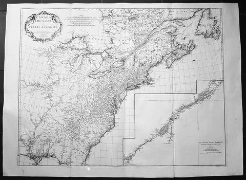
This magnificent, scarce, very large (48in x 35in) & highly detail map of North America was engraved in 1755 - dated in the title cartouche - by George De La Haye and was published by Jean Baptiste Bourguignon D'Anville in his large elephant folio atlas Atlas Generale.
Geopolitically this map is extremely significant drawn as war between the Global Powers of the day, France, England & Spain, was breaking, known in Europe as the Seven Year War known in North America as the French & Indian war. (Please see below for more detail)
This map rivals John Mitchells "A Map of the British and French Dominions in North America published in 1755" - considered to be one of the most significant maps of North America published in the 18th & 19th centuries (a 1st edition of Mitchells map is currently for sale for $165,000).
I have included an image of the Mitchell map for comparison. The D' Anville map is considered by many to be cartographically superior to the Mitchell map, at a fraction of the price.
Background: This extraordinary map of the eastern half of North America extends from Newfoundland, Canada to St. Augustine, Florida, stretching westward beyond the Mississippi as far as modern day Texas. The map includes both the original colonial colonies along the Atlantic seaboard from Maine to Georgia and the French claims in Louisiana (the Mississippi Valley) and modern day Canada. Florida is acknowledged as a Spanish enclave. Elevation is rendered in profile with fortifications, towns, and American Indian villages identified. A large inset map centres on the course of the St. Lawrence River from the Isle Aux Coudres to Lake Ontario.
The is a very significant map, drawn from a definitive French perspective, defining the territorial alignments and claims within North America shortly following the outbreak of the French and Indian War, considered to be a New World reflection of the European Seven Years War. It is however notable that it began before the larger hostilities in Europe and most of the major battles involved primarily parties only loosely aligned with the French or English - most specifically American Indians and lawless frontiersman, who had their own political agenda.
The war began with French incursions into western Pennsylvania and other territories claimed simultaneously by the French, English and American Indian forces. Just prior to the war, the French, in the interest of broadening their hold on the lucrative fur trade, established a series of forts, all of which are here noted, along the length of the Mississippi and further east, including Fort Duquesne (here Fort de Quene, Pittsburgh), Fort de la Presquisle, and for Le Beouf (here, Fort de la Riv Jaus Beufs).
The map also recognizes British claims, only inland as far as the Appalachian Mountains, beyond which place names take on a noticeably French character. These last three forts occupied particularly contested territory under the control of the powerful British allied Iroquois League. The most contested of these was Fort Duquesne (modern day Pittsburgh) in direct opposition to another fort then being constructed by the Ohio Company, a trading and land speculation firm established by prominent Virginia colonials, including George Washington. The Virginian colonial governor responded to Duquesne by sending then Lieutenant George Washington and a band of Virginia militiamen to harass the French. The resulting Jumonville Affair, in which Washington oversaw an attack on a French Canadian diplomatic forces led by Joseph Coulon de Villiers de Jumonville, to warn the Ohio Company fort builders away from French claimed territory. The slaying of Jumonville and several other French diplomats prompted a response from French forces at Fort Duquesne, leading to Washington's retreat and construction of Fort Necessity, really little more than a palisaded shack, marked here just south of Fort Duquesne. These events, all of which occurred in May of 1754, were said to have increased hostilities in Europe and led to the start of the Seven Year War in 1755.
Beyond the political agenda of this map, is the map itself, being one of the finest and most heavily detailed maps of North America published in the mid 18th century. Ranking alongside the large 1755 Mitchell map in detail but judged by many as cartographically superior. Drawing on both French and British cartographical detail, D' Anville identifies countless American Indian tribes, many of which, like the Sioux and Missouri, the British had only vague knowledge. Moreover, he also includes detail such as swamps, rapids, fords, abandoned villages, and even the ancient remnants of mound builder culture in the Ohio Valley. D' Anville notably does not include Mitchell's fictional Lake Superior islands.
This map was originally published to accompany the pamphlet entitledMemoire sur la carte intitulee: Canada, Louisiane, & Terres angloises and was also published in four parts for D' Anville's Atlas General.
These large maps are hard to find in such good condition and make fantastic historical reference tools due to the size and high level of detail as with all D' Anvilles work. (Ref: Tooley, M&B)
General Description:
Paper thickness and quality: - Heavy and stable
Paper color: - White
Age of map color: - Original & late
Colors used: - Yellow, green, pink
General color appearance: - Authentic
Paper size: - 46 1/2in x 35 3/4in (1.17m x 910mm)
Plate size: - 45in x 35in (1.12m x 890mm)
Margins: - Min 1in (25mm)
Imperfections:
Margins: - None
Plate area: - Light soiling & ceasing along folds
Verso: - Light soiling
1755 JB D Anville Large Original Antique Map of North America, Great Lakes, Indian Wars
- Title : Canada Louisiane et Terres Anglois Par Le Sr. D Anville...MDCCLV
- Ref #: 61140
- Size: 52in x 38in (1.32m x 960mm)
- Date : 1755
- Condition: (A+) Fine Condition
Description:
This magnificent, scarce, very large (52in x 38in) & highly detail map of North America was engraved in 1755 - dated in the title cartouche - by George De La Haye and was published by Jean Baptiste Bourguignon D Anville in his large elephant folio atlas Atlas Generale.
Geopolitically this map is extremely significant drawn as war between the Global Powers of the day, France, England & Spain, was breaking, known in Europe as the Seven Year War known in North America as the French & Indian war. (Please see below for more detail)
This map rivals John Mitchells "A Map of the British and French Dominions in North America published in 1755" - considered to be one of the most significant maps of North America published in the 18th & 19th centuries (a 1st edition of Mitchells map is currently for sale for $165,000).
I have included an image of the Mitchell map for comparison. The D Anville map is considered by many to be cartographically superior to the Mitchell map, at a fraction of the price.
General Description:
Paper thickness and quality: - Heavy and stable
Paper color: - White
Age of map color: -
Colors used: -
General color appearance: -
Paper size: - 52in x 38in (1.32m x 960mm)
Plate size: - 45in x 35in (1.12m x 890mm)
Margins: - Min 1in (25mm)
Imperfections:
Margins: - None
Plate area: - Light ceasing along folds
Verso: - Very small worm holes
Background: This extraordinary map of the eastern half of North America extends from Newfoundland, Canada to St. Augustine, Florida, stretching westward beyond the Mississippi as far as modern day Texas. The map includes both the original colonial colonies along the Atlantic seaboard from Maine to Georgia and the French claims in Louisiana (the Mississippi Valley) and modern day Canada. Florida is acknowledged as a Spanish enclave. Elevation is rendered in profile with fortifications, towns, and American Indian villages identified. A large inset map centres on the course of the St. Lawrence River from the Isle Aux Coudres to Lake Ontario.
The is a very significant map, drawn from a definitive French perspective, defining the territorial alignments and claims within North America shortly following the outbreak of the French and Indian War, considered to be a New World reflection of the European Seven Years War. It is however notable that it began before the larger hostilities in Europe and most of the major battles involved primarily parties only loosely aligned with the French or English - most specifically American Indians and lawless frontiersman, who had their own political agenda.
The war began with French incursions into western Pennsylvania and other territories claimed simultaneously by the French, English and American Indian forces. Just prior to the war, the French, in the interest of broadening their hold on the lucrative fur trade, established a series of forts, all of which are here noted, along the length of the Mississippi and further east, including Fort Duquesne (here Fort de Quene, Pittsburgh), Fort de la Presquisle, and for Le Beouf (here, Fort de la Riv Jaus Beufs).
The map also recognizes British claims, only inland as far as the Appalachian Mountains, beyond which place names take on a noticeably French character. These last three forts occupied particularly contested territory under the control of the powerful British allied Iroquois League. The most contested of these was Fort Duquesne (modern day Pittsburgh) in direct opposition to another fort then being constructed by the Ohio Company, a trading and land speculation firm established by prominent Virginia colonials, including George Washington. The Virginian colonial governor responded to Duquesne by sending then Lieutenant George Washington and a band of Virginia militiamen to harass the French. The resulting Jumonville Affair, in which Washington oversaw an attack on a French Canadian diplomatic forces led by Joseph Coulon de Villiers de Jumonville, to warn the Ohio Company fort builders away from French claimed territory. The slaying of Jumonville and several other French diplomats prompted a response from French forces at Fort Duquesne, leading to Washingtons retreat and construction of Fort Necessity, really little more than a palisaded shack, marked here just south of Fort Duquesne. These events, all of which occurred in May of 1754, were said to have increased hostilities in Europe and led to the start of the Seven Year War in 1755.
Beyond the political agenda of this map, is the map itself, being one of the finest and most heavily detailed maps of North America published in the mid 18th century. Ranking alongside the large 1755 Mitchell map in detail but judged by many as cartographically superior. Drawing on both French and British cartographical detail, D Anville identifies countless American Indian tribes, many of which, like the Sioux and Missouri, the British had only vague knowledge. Moreover, he also includes detail such as swamps, rapids, fords, abandoned villages, and even the ancient remnants of mound builder culture in the Ohio Valley. D Anville notably does not include Mitchells fictional Lake Superior islands.
This map was originally published to accompany the pamphlet entitledMemoire sur la carte intitulee: Canada, Louisiane, & Terres angloises and was also published in four parts for D Anvilles Atlas General.
These large maps are hard to find in such good condition and make fantastic historical reference tools due to the size and high level of detail as with all D Anvilles work. (Ref: Tooley, M&B)
1755 Thomas Bowen & D' Anville Large Antique Map of South America
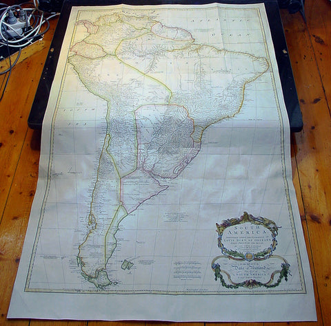
- Title : South America Performed Under The Patronage of Louis Duke of Oreleans....T. Bowen 1755
- Date : 1755
- Condition: (A+) Fine Condition
- Ref: 92345
- Size: 51 1/2in x 31 1/2in (1.31mm x 800mm)
Description:
This very large 3 sheet joined copper-plate engraved original antique map of South America was engraveClaude Ptolemydd by Thomas Bowen in 1755 - the date is engraved at the foot of the map - and was published by Solomon Bolton for Malachy Postlethweyt's 2 Volumes publication of Dictionary of Trade & Commercepublished in 1757.
The cartographical detail was borrowed from the same Jean-Baptiste Bourguinon D'Anville map published in the 1760 edition of his large elephant folio atlas Atlas Generale.
Background:
This map from the second edition of this famous dictionary, based in part on the Dictionaries universel de Commerce (Paris: 1723-30) of Jacques Savary de Bruslon, under whose name it is often catalogued, but was adapted by Postlethwayt for a British audience, with substantial enlargements and improvements, and entirely new material relating to England and her colonies. Postlethwayt devoted twenty years to the preparation of the dictionary, which was first published in 1751-55. The dictionary included a description of British affairs in North America since the peace of 1763. As with his other works, the dictionary demonstrates Postlethway’s deep commitment to the expansion and strengthening of English trade. Included are entries for geographical locations (Africa, Antilles, Canada, Japan, Louisiana, &c.), products (brandy, cardamom, codfish, diamonds, sugar, &c.), trading companies (Dutch East India Company, English African Company, &c.), treaties of commerce, and a vast range of other information of value to merchants (bankruptcy, currency, bills of exchange, brokerage, exportation, landed interest, privateering, &c.).
The Dictionary is also important for containing almost the whole substance of Richard Cantillon’s Essay on Commerce, its first appearance in print (see Henry Higgs’1931 edition and translation of Cantillon). The substantial maps, engraved by T.Kitchin and R.S.Seale after J.B.B. D’Anville and S.Bolton, depict Europe (4 sheets), Asia (8 sheets), North America (4 sheets), South America (3 sheets), and Africa (3 sheets). (Ref: Tooley; M&B)
General Description:
Paper thickness and quality: - Heavy and stable
Paper color: - white
Age of map color: - Early & later
Colors used: - Yellow, green, pink, blue
General color appearance: - Authentic
Paper size: - 51 1/2in x 31 1/2in (1.31mm x 800mm)
Plate size: - 48 1/2in x 30 1/2in (1.23mm x 770mm)
Margins: - min. 1in (25m)
Imperfections:
Margins: - None
Plate area: - Folds as issued, light creasing along folds
Verso: - None
1756 D Anville Large Antique Map of Greece & The Aegean Islands & Crete
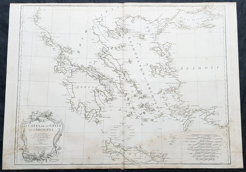
- Title : Les Cotes de la Grece et L Archipel par le D Anville...MDCCLVI (1756)
- Size: 31in x 24in (790mm x 610mm)
- Condition: (A) Very Good Condition
- Date : 1756
- Ref #: 92313
Description:
This large hand coloured original copper-plate engraved antique map of the Aegean Islands of Greece, south to Crete by Jean Baptiste Bourguignon D Anville was engraved in 1756 - dated in the tile cartouche - and was published in Jean-Baptiste Bourguinon D Anvilles large elephant folio atlas Atlas Generale. (Ref: Tooley, M&B)
General Definitions:
Paper thickness and quality: - Heavy and stable
Paper color : - off white
Age of map color: -
Colors used: -
General color appearance: -
Paper size: - 31in x 24in (790mm x 610mm)
Plate size: - 29in x 24in (770mm x 610mm)
Margins: - Min 1/2in (12mm)
Imperfections:
Margins: - Soiling in margins
Plate area: - Soiling bottom of image
Verso: - Soiling
Background:
The Aegean Islands are the group of islands in the Aegean Sea, with mainland Greece to the west and north and Turkey to the east; the island of Crete delimits the sea to the south, those of Rhodes, Karpathos and Kasos to the southeast. The ancient Greek name of the Aegean Sea, Archipelago (ἀρχιπέλαγος, archipelagos) was later applied to the islands it contains and is now used more generally, to refer to any island group.
The vast majority of the Aegean Islands belong to Greece, being split among nine administrative regions. The only sizable possessions of Turkey in the Aegean Sea are Imbros (Gökçeada) and Tenedos (Bozcaada), in the northeastern part of the Sea. Various smaller islets off Turkeys western coast are also under Turkish sovereignty.
1756 J B D Anville Large Antique Map Greece, Crete, Corfu, Aegean Isles Turkey
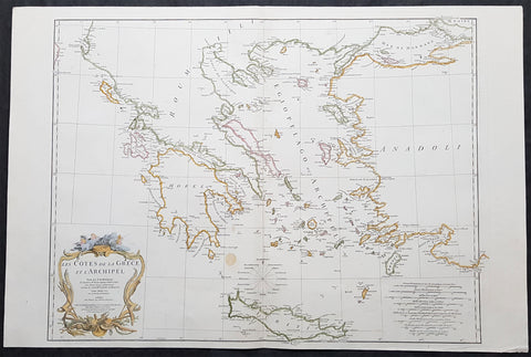
- Title : Les Cotes De La Grece et L Archipel...MDCCLVI
- Size: 34in x 23in (865m x 585mm)
- Condition: (A) Very Good Condition
- Date : 1756
- Ref #: 21996
Description:
This large original copper-plate engraved antique map of Greece, Crete & the Greek Islands by Jean Baptiste Bourguignon D\'Anville was engraved in 1756 - dated in the tile cartouche - and was published in Jean-Baptiste Bourguinon D\'Anvilles large elephant folio atlas Atlas Generale. (Ref: Tooley, M&B)
General Definitions:
Paper thickness and quality: - Heavy and stable
Paper color : - off white
Age of map color: - Early
Colors used: - Yellow, pink, green, blue
General color appearance: - Authentic
Paper size: - 34in x 23in (865m x 585mm)
Plate size: - 29in x 22in (735mm x 560mm)
Margins: - Min 1/2in (12mm)
Imperfections:
Margins: - None
Plate area: - None
Verso: - None
Background:
While most of mainland Greece and the Aegean islands was under Ottoman control by the end of the 15th century, Cyprus and Crete remained Venetian territory and did not fall to the Ottomans until 1571 and 1670 respectively. The only part of the Greek-speaking world that escaped long-term Ottoman rule was the Ionian Islands, which remained Venetian until their capture by the First French Republic in 1797, then passed to the United Kingdom in 1809 until their unification with Greece in 1864.
While some Greeks in the Ionian Islands and Constantinople lived in prosperity, and Greeks of Constantinople (Phanariotes) achieved positions of power within the Ottoman administration, much of the population of mainland Greece suffered the economic consequences of the Ottoman conquest. Heavy taxes were enforced, and in later years the Ottoman Empire enacted a policy of creation of hereditary estates, effectively turning the rural Greek populations into serfs.
The Greek Orthodox Church and the Ecumenical Patriarchate of Constantinople were considered by the Ottoman governments as the ruling authorities of the entire Orthodox Christian population of the Ottoman Empire, whether ethnically Greek or not. Although the Ottoman state did not force non-Muslims to convert to Islam, Christians faced several types of discrimination intended to highlight their inferior status in the Ottoman Empire. Discrimination against Christians, particularly when combined with harsh treatment by local Ottoman authorities, led to conversions to Islam, if only superficially. In the 19th century, many crypto-Christians returned to their old religious allegiance.
The nature of Ottoman administration of Greece varied, though it was invariably arbitrary and often harsh. Some cities had governors appointed by the Sultan, while others (like Athens) were self-governed municipalities. Mountainous regions in the interior and many islands remained effectively autonomous from the central Ottoman state for many centuries.
When military conflicts broke out between the Ottoman Empire and other states, Greeks usually took up arms against the Ottomans, with few exceptions. Prior to the Greek Revolution of 1821, there had been a number of wars which saw Greeks fight against the Ottomans, such as the Greek participation in the Battle of Lepanto in 1571, the Epirus peasants\' revolts of 1600–1601 (led by the Orthodox bishop Dionysios Skylosophos), the Morean War of 1684–1699, and the Russian-instigated Orlov Revolt in 1770, which aimed at breaking up the Ottoman Empire in favor of Russian interests.[89][page needed] These uprisings were put down by the Ottomans with great bloodshed. On the other side, many Greeks were conscripted as Ottoman citizens to serve in the Ottoman army (and especially the Ottoman navy), while also the Ecumenical Patriarchate of Constantinople, responsible for the Orthodox, remained in general loyal to the empire.
The 16th and 17th centuries are regarded as something of a dark age in Greek history, with the prospect of overthrowing Ottoman rule appearing remote with only the Ionian islands remaining free of Turkish domination. Corfu withstood three major sieges in 1537, 1571 and 1716 all of which resulted in the repulsion of the Ottomans. However, in the 18th century, due to their mastery of shipping and commerce, a wealthy and dispersed Greek merchant class arose. These merchants came to dominate trade within the Ottoman Empire, establishing communities throughout the Mediterranean, the Balkans, and Western Europe. Though the Ottoman conquest had cut Greece off from significant European intellectual movements such as the Reformation and the Enlightenment, these ideas together with the ideals of the French Revolution and romantic nationalism began to penetrate the Greek world via the mercantile diaspora. In the late 18th century, Rigas Feraios, the first revolutionary to envision an independent Greek state, published a series of documents relating to Greek independence, including but not limited to a national anthem and the first detailed map of Greece, in Vienna, and was murdered by Ottoman agents in 1798.
1756 J B D Anville Large Antique Map of Egypt & The Red Sea
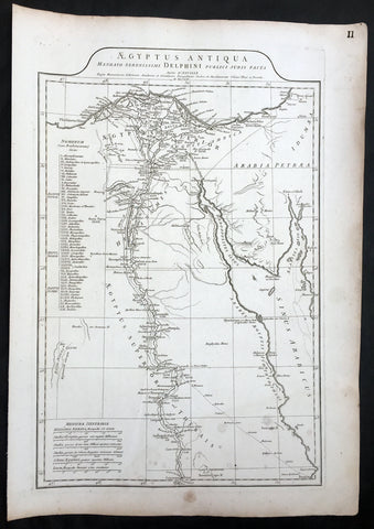
- Title : Aegyptus Antiqua..Auctor D Anville...MDCCLXV (1765)
- Size: 22in x 15 1/2in (560mm x 395mm)
- Condition: (A) Very Good Condition
- Date : 1765
- Ref #: 92303
Description:
This large original copper-plate engraved antique map of Egypt & the Read Sea by Jean Baptiste Bourguignon D\'Anville was engraved in 1765 - dated in the tile cartouche - and was published in Jean-Baptiste Bourguinon D\'Anvilles large elephant folio atlas Atlas Generale. (Ref: Tooley, M&B)
General Definitions:
Paper thickness and quality: - Heavy and stable
Paper color : - off white
Age of map color: -
Colors used: -
General color appearance: -
Paper size: - 22in x 15 1/2in (560mm x 395mm)
Plate size: - 20in x 13in (510mm x 330mm)
Margins: - Min 1in (25mm)
Imperfections:
Margins: - Light soiling
Plate area: - Light soiling
Verso: - Light soiling
Background:
Being part of the Mediterranean world, the northern coasts of the African continent as far as the Straits of Gibraltar and even round to the area of the Fortunate Isles (the Canaries) were reasonably well known and quite accurately mapped from ancient times. In particular, Egypt and the Nile Valley were well defined and the Nile itself was, of course, one of the rivers separating the continents in medieval T-O maps. Through Arab traders the shape of the east coast, down the Red Sea as far as the equator, was also known but detail shown in the interior faded into deserts with occasional mountain ranges and mythical rivers. The southern part of the continent, in the Ptolemaic tradition, was assumed to curve to the east to form a land-locked Indian Ocean. The voyages of the Portuguese, organized by Henry the Navigator in the fifteenth century, completely changed the picture and by the end of the century Vasco da Gama had rounded the Cape enabling cartographers to draw a quite presentable coastal outline of the whole continent, even if the interior was to remain largely unknown for the next two or three centuries.
The first separately printed map of Africa (as with the other known continents) appeared in Munster\\\'s Geographia from 1540 onwards and the first atlas devoted to Africa only was published in 1588 in Venice by Livio Sanuto, but the finest individual map of the century was that engraved on 8 sheets by Gastaldi, published in Venice in 1564. Apart from maps in sixteenth-century atlases generally there were also magnificent marine maps of 1596 by Jan van Linschoten (engraved by van Langrens) of the southern half of the continent with highly imaginative and decorative detail in the interior. In the next century there were many attractive maps including those of Mercator/Hondius (1606), Speed (1627), Blaeu (1 630), Visscher (1636), de Wit (c. 1670), all embellished with vignettes of harbours and principal towns and bordered with elaborate and colourful figures of their inhabitants, but the interior remained uncharted with the exception of that part of the continent known as Ethiopia, the name which was applied to a wide area including present-day Abyssinia. Here the legends of Prester John lingered on and, as so often happened in other remote parts of the world, the only certain knowledge of the region was provided by Jesuit missionaries. Among these was Father Geronimo Lobo (1595-1678), whose work A Voyage to Abyssinia was used as the basis for a remarkably accurate map published by a German scholar, Hiob Ludolf in 1683. Despite the formidable problems which faced them, the French cartographers G. Delisle (c. 1700-22), J. B. B. d\\\'Anville (1727-49) and N. Bellin (1754) greatly improved the standards of mapping of the continent, improvements which were usually, although not always, maintained by Homann, Seutter, de Ia Rochette, Bowen, Faden and many others in the later years of the century.
1758 D Anville Very Large Antique Map of Norway Sweden Iceland, Baltics & Russia
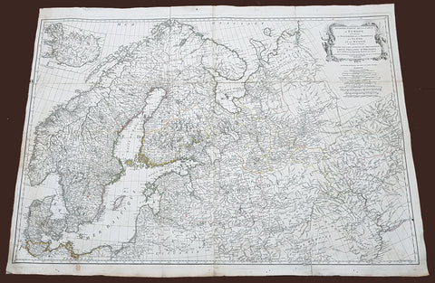
- Title : Seconde Partie de la Carte D Europe contenant Le Danemark et la Norwege, La Suede et la Russie....MDCCLVIII
- Size: 40 1/2in x 29 1/2in (1.02m x 760mm)
- Condition: (A) Very Good Condition
- Date : 1758
- Ref #: 92308
Description:
This scarce, very large (40in x 29in) highly detail map of Northern Europe Norway, Sweden, Lithuania, Baltic Countries and European Russia - was engraved in 1758 - dated in the title cartouche - by George De La Haye and was published by Jean Baptiste Bourguignon D\'Anville in his large elephant folio atlas Atlas Generale.
General Definitions:
Paper thickness and quality: - Heavy and stable
Paper color : - off white
Age of map color: - Original
Colors used: - Yellow, Green, pink
General color appearance: - Authentic
Paper size: - 40 1/2in x 29 1/2in (1.02m x 760mm)
Plate size: - 40in x 28 1/2in (1.0m x 725mm)
Margins: - Min 1/2in (12mm)
Imperfections:
Margins: - Light toning
Plate area: - Folds as issued, light separation at corners of folds
Verso: - Age toning
Background:
Before the fifteenth century the people of Southern Europe had little geographical knowledge of the Scandinavian World except from sketchy detail shown in the Catalan Atlas (1375) and on a number of portolani embracing Denmark and the southern tip of Norway. It was not until 1427 that a manuscript map prepared about that time by Claudius Clavus (b.1388) a Dane who spent some time in Rome, made available to scholars a tolerable outline of the northern countries and Greenland. That was to remain the best map available for the rest of the century and it was used as the basis for maps of Scandinavia in early printed editions of Ptolemy. Others by Nicolaus Cusanus (1491) and Ehrhard Etzlaub (c. 1492) followed but, needless to say, these are extremely rare; even the later maps by Olaus Magnus and Marcus Jordan, where they have survived at all , are known only by a very few examples. In fact, apart from the rare appearance of an early Ptolemy map, the oldest of Scandinavia which a collector is likely to find are those of Munster\'s Cosmograhy first published in 1544. In the following centuries the few maps and charts complied in Scandinavia were usually published in Amsterdam, Antwerp, Paris or Nuremberg, the most important maps often being incorporated in the major Dutch, French & German Atlases. (Ref: Tooley; M&B)
1759 J.B. D' Anville Large Original Antique Map of Africa - Beautiful
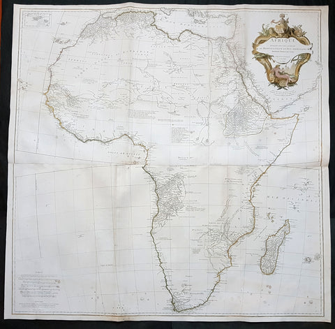
- Title : Afrique Publiee sous les Auspices de Monseigneur le Duc D\'Orleans Premier Prince du Sang Par le Sr D Anville MDCCXLIX
- Date : 1759
- Condition: (A) Very Good Condition
- Ref: 92322
- Size: 40in x 40in (1.02m x 1.02m)
Description:
This large finely engraved and highly detailed original antique map of Africa by Jean Baptiste Bourguignon D'Anville was engraved in 1759 - dated in the tile cartouche - by Guillaume Delahaye and was published D'Anville's large elephant folio Atlas Generale.
This is one of the largest and most influential maps of Africa to appear in the mid-18th century. Anville\'s map covers the entire continent of Africa from the Mediterranean to the Cape of Good Hope and from the Cape Verde Islands to Madagascar. Anville was a careful cartographer known for his scientific approach to mapmaking, and nowhere is this more evident than in this, his greatest and most innovative map of Africa. Following the trajectory set by Guillaume de L\'Isle half a century earlier, D\'Anville takes a number of significant steps forward in addressing the confusions inherent in mapping this vast though mostly, in the mid-17th century, unexplored continent. These include unreliable cartographic suppositions regarding the African interior dating practically to antiquity. Many of these, including such speculative ideas as the \'Mountains of Kong,\' have been diminished if not removed entirely from this map, leaving vast unexplored areas throughout.
What was known of Africa, however, Anville incorporates here in an impressive compilation of the most up to date reports from colonial, missionary, and exploratory entradas into the interior of the continent. Thus well mapped parts of the continent are limited to the Mediterranean Coast, Morocco, the Senegambia, the Congo, South Africa, the Kingdom of Monomatapa, Abyssinia, and egypt. Morocco, egypt, and the southern Mediterranean Coast (Barbary) were well known to europeans since antiquity and Anville\'s accurate mapping of these regions reflects continual contact. Further south the colonial enclaves along the Niger River (Senegal and Gambia), the Congo River, and South Africa reflect considerable detail associated with european penetration by trader and missionaries. The land of Monomopota around the Zambezi River was explored early in the 16th century by the Portuguese in hopes that the legendary gold mines supposedly found there would counterbalance the wealth flowing into Spain from the New Word. Unfortunately these mines, often associated with the Biblical kingdom of Ophir, were mostly tapped out by the 15th century. Abyssinia (modern day ethiopia) was mapped in detail by early Italian missionaries and of considerable interest to europeans first, because it was (and is) predominantly Christian; second, because it was a powerful well-organized and unified kingdom; and third because the sources of the Blue Nile were to be found here.
The remainder of the continent remained largely speculative though Anville rarely lets his imagination get the upper hand. He does however follow the well-established Ptolemaic model laid down in the Geographica regarding the sources of the White Nile – here seen as two lakes at the base of the semi-apocryphal Mountains of the Moon. However, he also presents a curious network of interconnected rivers extending westward from the confused course of the White Nile following the popular 18th century speculation that the Nile may be connected to the Niger. To his credit Anville does not advocate this and offers no true commerce between the two river systems.
Lake Malawi, here identified as Maravi, appears in a long thin embryonic state that, though it had not yet been \'discovered,\' is remarkably accurate to form. Lake Malawi was not officially discovered until Portuguese trader Candido Jose da Costa Cardoso stumbled upon it in 1849 – one hundred years following Anville\'s presentation of the lake here. Anville\'s inclusion of Lake Malawi is most likely a prescient interpretation of indigenous reports brought to europe by 17th century Portuguese traders. Its form would be followed by subsequent cartographers well into the mid-19th century when the explorations of John Hanning Speke, David Livingstone, Richard Francis Burton and others would at last yield a detailed study of Africa\'s interior.
General Definitions:
Paper thickness and quality: - Heavy and stable
Paper color : - off white
Age of map color: - Original & later
Colors used: - Yellow, green, blue, pink
General color appearance: - Authentic
Paper size: - 40in x 40in (1.02m x 1.02m)
Plate size: - 39in x 39in (1.0m x 1.0m)
Margins: - Min 1/2in (12mm)
Imperfections:
Margins: - None
Plate area: - Light spotting bottom of image, folds as issued, light toning along folds
Verso: - Light spotting bottom of image, folds as issued, light toning along folds
Background:
Being part of the Mediterranean world, the northern coasts of the African continent as far as the Straits of Gibraltar and even round to the area of the Fortunate Isles (the Canaries) were reasonably well known and quite accurately mapped from ancient times. In particular, Egypt and the Nile Valley were well defined and the Nile itself was, of course, one of the rivers separating the continents in medieval T-O maps. Through Arab traders the shape of the east coast, down the Red Sea as far as the equator, was also known but detail shown in the interior faded into deserts with occasional mountain ranges and mythical rivers. The southern part of the continent, in the Ptolemaic tradition, was assumed to curve to the east to form a land-locked Indian Ocean. The voyages of the Portuguese, organized by Henry the Navigator in the fifteenth century, completely changed the picture and by the end of the century Vasco da Gama had rounded the Cape enabling cartographers to draw a quite presentable coastal outline of the whole continent, even if the interior was to remain largely unknown for the next two or three centuries.
The first separately printed map of Africa (as with the other known continents) appeared in Munster\'s Geographia from 1540 onwards and the first atlas devoted to Africa only was published in 1588 in Venice by Livio Sanuto, but the finest individual map of the century was that engraved on 8 sheets by Gastaldi, published in Venice in 1564. Apart from maps in sixteenth-century atlases generally there were also magnificent marine maps of 1596 by Jan van Linschoten (engraved by van Langrens) of the southern half of the continent with highly imaginative and decorative detail in the interior. In the next century there were many attractive maps including those of Mercator/Hondius (1606), Speed (1627), Blaeu (1 630), Visscher (1636), de Wit (c. 1670), all embellished with vignettes of harbours and principal towns and bordered with elaborate and colourful figures of their inhabitants, but the interior remained uncharted with the exception of that part of the continent known as Ethiopia, the name which was applied to a wide area including present-day Abyssinia. Here the legends of Prester John lingered on and, as so often happened in other remote parts of the world, the only certain knowledge of the region was provided by Jesuit missionaries. Among these was Father Geronimo Lobo (1595-1678), whose work A Voyage to Abyssinia was used as the basis for a remarkably accurate map published by a German scholar, Hiob Ludolf in 1683. Despite the formidable problems which faced them, the French cartographers G. Delisle (c. 1700-22), J. B. B. d\'Anville (1727-49) and N. Bellin (1754) greatly improved the standards of mapping of the continent, improvements which were usually, although not always, maintained by Homann, Seutter, de Ia Rochette, Bowen, Faden and many others in the later years of the century. (Ref: Tooley; M&B)
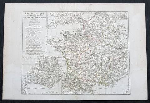
1760 J B D Anville Large Antique Map of Roman France
- Title : Gallia Antiqua ex Aevi Romani......D Anville...MDCCLX
- Size: 30in x 21in (760mm x 535mm)
- Condition: (A) Very Good Condition
- Date : 1760 (dated)
- Ref #: 92296
Description:
This large original copper plate engraved antique map of Roman France was engraved in 1760 - dated in the tile cartouche - and was published in Jean-Baptiste Bourguinon D Anvilles large elephant folio atlas Atlas Generale.
General Definitions:
Paper thickness and quality: - Heavy and stable
Paper color : - off white
Age of map color: - Original
Colors used: - Yellow, Green, pink
General color appearance: - Authentic
Paper size: - 30in x 21in (760mm x 535mm)
Plate size: - 23 1/2in x 18 1/4in (595mm x 465mm)
Margins: - Min 1/2in (12mm)
Imperfections:
Margins: - Creasing, light age toning
Plate area: - Creasing
Verso: - Creasing, light age toning
Background:
In 600 BC, Ionian Greeks, originating from Phocaea, founded the colony of Massalia (present-day Marseille), on the shores of the Mediterranean Sea. This makes it Frances oldest city. At the same time, some Gallic Celtic tribes penetrated parts of the current territory of France, and this occupation spread to the rest of France between the 5th and 3rd century BC.
The concept of Gaul emerged at that time; it corresponds to the territories of Celtic settlement ranging between the Rhine, the Atlantic Ocean, the Pyrenees and the Mediterranean. The borders of modern France are roughly the same as those of ancient Gaul, which was inhabited by Celtic Gauls. Gaul was then a prosperous country, of which the southernmost part was heavily subject to Greek and Roman cultural and economic influences.
Around 390 BC the Gallic chieftain Brennus and his troops made their way to Italy through the Alps, defeated the Romans in the Battle of the Allia, and besieged and ransomed Rome. The Gallic invasion left Rome weakened, and the Gauls continued to harass the region until 345 BC when they entered into a formal peace treaty with Rome. But the Romans and the Gauls would remain adversaries for the next centuries, and the Gauls would continue to be a threat in Italy.
Around 125 BC, the south of Gaul was conquered by the Romans, who called this region Provincia Nostra (Our Province), which over time evolved into the name Provence in French. Julius Caesar conquered the remainder of Gaul and overcame a revolt carried out by the Gallic chieftain Vercingetorix in 52 BC. According to Plutarch and the writings of scholar Brendan Woods, the Gallic Wars resulted in 800 conquered cities, 300 subdued tribes, one million men sold into slavery, and another three million dead in battle.
Gaul was divided by Augustus into Roman provinces. Many cities were founded during the Gallo-Roman period, including Lugdunum (present-day Lyon), which is considered the capital of the Gauls. These cities were built in traditional Roman style, with a forum, a theatre, a circus, an amphitheatre and thermal baths. The Gauls mixed with Roman settlers and eventually adopted Roman culture and Roman speech (Latin, from which the French language evolved). The Roman polytheism merged with the Gallic paganism into the same syncretism.
From the 250s to the 280s AD, Roman Gaul suffered a serious crisis with its fortified borders being attacked on several occasions by barbarians. Nevertheless, the situation improved in the first half of the 4th century, which was a period of revival and prosperity for Roman Gaul. In 312, Emperor Constantin I converted to Christianity. Subsequently, Christians, who had been persecuted until then, increased rapidly across the entire Roman Empire. But, from the beginning of the 5th century, the Barbarian Invasions resumed. Teutonic tribes invaded the region from present-day Germany, the Visigoths settling in the southwest, the Burgundians along the Rhine River Valley, and the Franks (from whom the French take their name) in the north.
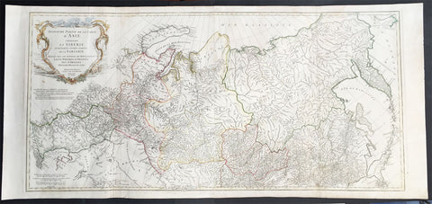
1762 D Anville Very Large Antique Map of Russia, Siberia, Mongolia, China, Japan
- Title : Troisieme Partie De La Carte D' Asia Contenant La Siberie...MDCCLII
- Ref #: 50604
- Size: 55in x 22 1/2in (1.25m x 570mm)
- Date : 1762
- Condition: (A+) Fine Condition
Description:
This very large beautifully engraved hand coloured original antique map of Russia, Siberia and Central Asia was engraved by Jean-Baptiste Bourguinon D'Anville in 1762 - the date is engraved in the title - and was published in the large elephant folio atlas Atlas Generale.
These maps are hard to find in such good condition and make fantastic historical reference tools due to the size and high level of detail as with all D'Anvilles work. (Ref: Tooley, M&B)
General Description:
Paper thickness and quality: - Heavy and stable
Paper color: - White
Age of map color: - Original
Colors used: - Yellow, pink, green
General color appearance: - Authentic
Paper size: - 55in x 22 1/2in (1.25m x 570mm)
Plate size: - 43in x 21in (1.10mm x 535mm)
Margins: - Min 1in (25mm)
Imperfections:
Margins: - None
Plate area: - Light creasing & soiling along L&R folds
Verso: - None
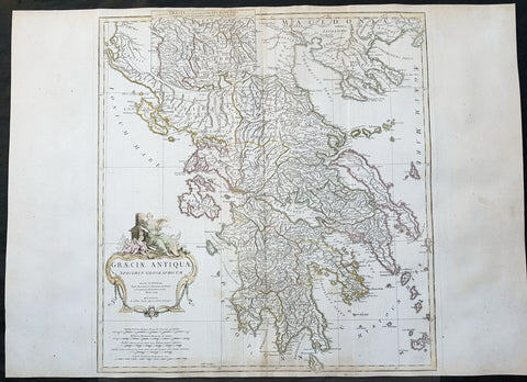
1762 J B D Anville Large Original Antique Map of Greece & Balkans
- Title : Graeciae Antiquae...MDCCLXII
- Date : 1762
- Size: 29 1/2in x 21 1/2in (750mm x 545mm)
- Ref #: 92298
- Condition: (A) Very Good Condition
Description:
This large finely engraved and highly detailed original antique map of Greece by Jean Baptiste Bourguignon D\'Anville was engraved in 1762 - dated in the tile cartouche - and was published in Jean-Baptiste Bourguinon D\'Anville\'s large elephant folio atlas Atlas Generale.
General Definitions:
Paper thickness and quality: - Heavy and stable
Paper color : - off white
Age of map color: - Early
Colors used: - Yellow, green, pink, blue
General color appearance: - Authentic
Paper size: - 29 1/2in x 21 1/2in (750mm x 545mm)
Plate size: - 21in x 20in (535mm x 510mm)
Margins: - Min 1/2in (12mm)
Imperfections:
Margins: - Age toning bottom margin
Plate area: - Creasing along centerfold
Verso: - Creasing along centerfold
Background:
From the early days of map-making, cartographers have always had a keen interest he mapping of Greece and of the particular continental and insular Greek areas. In other words the \"Greek chorography\", as it is often called had been a cartographic item of special importance, both in manuscript and printed cartography, the later having produced an impressive number of Greek maps. All of these have been include in almost all the European Atlases and travel books, since the first printed edition of Ptolemy\'s Gepgraphia in1447. This prominent presence of Greece in the field of European cartography is due to various historic, political and cultural reasons.
In the first place, the Eastern Mediterranean basin has been for many centuries the center of the civilized European world and, consequently, an area of special attraction. It was only natural, therefore, that from the early days journeys to Greece made necessary the cartographic description of the region. The relevant mapping of the ancients was followed up and developed by the efficient Byzantium administration, thus providing a rich material which was later used by European cartographers of the 16th, 17th and 18th centuries.
Secondly, like any other artistic and scientific activity of the period under review, cartography was influenced by and reflected intense interest in Greece, enhanced by the revival of Greek culture and the flourishing of Classical studies during and after the renaissance.
Finally, the prolific production of Greek maps is due to the fact that, quite often cartographers used to delineate \"historical\" maps of Greece, with the ancient nomenclature and state structure, based manly on the Ptolemaic cartography and the works of all the classical authors, as well \"contemporary\" ones, which were the outcome of the journeys of travelers, merchants and intellectuals at the time. Greece was usually depicted as a province of the Ottoman empire or the Greek Islands as territories of the Venetian republic. Hence the distinction between maps of \"Graecia Antiqua\" and maps of \"Graecia Nova\" or \"European Turkey\" or \"Southern part of Turkey in Europe\" and the use of such Latin explanatory terms as \"Olim\" (formerly) and \"Nunc\" (presently) for the identification of places, according to their ancient (Greek, Latin) or contemporary (modern Greek, Turkish, Slavic, Italian) names.
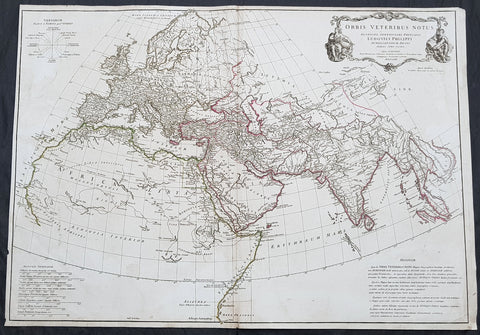
1763 D Anville Large Antique Map of The Ancient World of Ptolemy Britain to Siam
- Title : Orbis Veteribus Notus...D Anville...MDCCLXIII
- Size: 31in x 22in (790mm x 560mm)
- Condition: (A) Very Good Condition
- Date : 1763
- Ref #: 92293
Description:
This large original copper plate engraved antique map of the known Ancient World, during the time of Ptolemy, was engraved in 1763 - dated in the tile cartouche - and was published in Jean-Baptiste Bourguinon D Anvilles large elephant folio atlas Atlas Generale.
General Definitions:
Paper thickness and quality: - Heavy and stable
Paper color : - off white
Age of map color: - Original
Colors used: - Yellow, green, red
General color appearance: - Authentic
Paper size: - 31in x 22in (790mm x 560mm)
Plate size: - 31in x 22in (790mm x 560mm)
Margins: - Min 1/2in (12mm)
Imperfections:
Margins: - Light soiling
Plate area: - Light soiling
Verso: - Light soling
Background:
The map shows a modern outline of the regions of Europe known at the time of Ptolemy, using ancient place names and omitting regions which had not yet been discovered by Europeans.
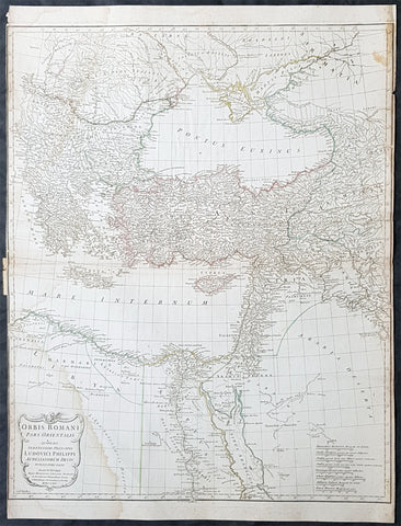
1764 D Anville Large Antique Map Byzantine, Eastern Roman Empire Europe to Egypt
- Title : Orbis Romani Pars Orientalis...Auctor D Anville...MDCCLXIV (1764)
- Size: 29in x 22in (740mm x 560mm)
- Condition: (A) Very Good Condition
- Date : 1764
- Ref #: 92295
Description:
This large hand coloured original copper-plate engraved antique map of the Eastern part of the post Roman Empire, from Eastern Europe to the Holy Land by Jean Baptiste Bourguignon D Anville was engraved in 1764 - dated in the tile cartouche - and was published in Jean-Baptiste Bourguinon D Anvilles large elephant folio atlas Atlas Generale. (Ref: Tooley, M&B)
General Definitions:
Paper thickness and quality: - Heavy and stable
Paper color : - off white
Age of map color: - Original
Colors used: - Yellow, Green, pink
General color appearance: - Authentic
Paper size: - 29in x 22in (740mm x 560mm)
Plate size: - 28in x 22in (730mm x 560mm)
Margins: - Min 1/4in (3mm)
Imperfections:
Margins: - Soiling in margins, L&R margins cropped close to border
Plate area: - Soiling bottom & top left
Verso: - Soiling
The Roman Empire was the post-Roman Republic period of the ancient Roman civilization, with a government headed by emperors and large territorial holdings around the Mediterranean Sea in Europe, Africa and Asia. The city of Rome was the largest city in the world c. 100 BC – c. AD 400, with Constantinople (New Rome) becoming the largest around AD 500, and the Empire\\\'s population grew to an estimated 50 to 90 million inhabitants (roughly 20% of the world\\\'s population at the time) The 500-year-old republic which preceded it had been severely destabilized in a series of civil wars and political conflict, during which Julius Caesar was appointed as perpetual dictator and then assassinated in 44 BC. Civil wars and executions continued, culminating in the victory of Octavian, Caesar\\\'s adopted son, over Mark Antony and Cleopatra at the Battle of Actium in 31 BC and the annexation of Egypt. Octavian\\\'s power was then unassailable and in 27 BC the Roman Senate formally granted him overarching power and the new title Augustus, effectively marking the end of the Roman Republic.
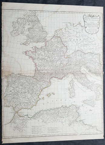
1764 D Anville Large Antique Map of the Western Roman Empire Dalmatia to Britain
- Title : Orbis Romani Pars Occidentalis...Auctor D Anville...MDCCLXIV (1763)
- Size: 29in x 22in (740mm x 560mm)
- Condition: (A) Very Good Condition
- Date : 1763
- Ref #: 92294
Description:
This large hand coloured original copper-plate engraved antique map of the Western part of the post Roman Empire, from Eastern Europe to Britain by Jean Baptiste Bourguignon D Anville was engraved in 1764 - dated in the tile cartouche - and was published in Jean-Baptiste Bourguinon D Anvilles large elephant folio atlas Atlas Generale. (Ref: Tooley, M&B)
General Definitions:
Paper thickness and quality: - Heavy and stable
Paper color : - off white
Age of map color: - Original
Colors used: - Yellow, Green, pink
General color appearance: - Authentic
Paper size: - 29in x 22in (740mm x 560mm)
Plate size: - 28in x 22in (730mm x 560mm)
Margins: - Min 1/4in (3mm)
Imperfections:
Margins: - Soiling in margins, L&R margins cropped close to border
Plate area: - Soiling bottom & top left
Verso: - Soiling
Background:
The Roman Empire was the post-Roman Republic period of the ancient Roman civilization, with a government headed by emperors and large territorial holdings around the Mediterranean Sea in Europe, Africa and Asia. The city of Rome was the largest city in the world c. 100 BC – c. AD 400, with Constantinople (New Rome) becoming the largest around AD 500, and the Empire\\\'s population grew to an estimated 50 to 90 million inhabitants (roughly 20% of the world\\\'s population at the time) The 500-year-old republic which preceded it had been severely destabilized in a series of civil wars and political conflict, during which Julius Caesar was appointed as perpetual dictator and then assassinated in 44 BC. Civil wars and executions continued, culminating in the victory of Octavian, Caesar\\\'s adopted son, over Mark Antony and Cleopatra at the Battle of Actium in 31 BC and the annexation of Egypt. Octavian\\\'s power was then unassailable and in 27 BC the Roman Senate formally granted him overarching power and the new title Augustus, effectively marking the end of the Roman Republic.
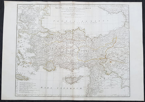
1764 J B D Anville Large Antique Map of Turkey, Cyprus, Syria, Black Sea
- Title : Asiae que Vulgo Minor Dicitur et Syria...Auctor D Anville...MDCCLXIV
- Ref : 92299
- Size: 30in x 21in (760mm x 535mm)
- Date : 1764
- Condition: (A) Very Good Condition
Description:
This large original copper plate engraved antique map of Turkey, Cyprus & Syria was engraved in 1764 - dated in the tile cartouche - and was published in Jean-Baptiste Bourguinon D Anvilles large elephant folio atlas Atlas Generale.
General Definitions:
Paper thickness and quality: - Heavy and stable
Paper color : - off white
Age of map color: - Original
Colors used: - Yellow, Green, pink
General color appearance: - Authentic
Paper size: - 30in x 21in (760mm x 535mm)
Plate size: - 25in x 20in (635mm x 515mm)
Margins: - Min 1/2in (12mm)
Imperfections:
Margins: - Creasing
Plate area: - Creasing
Verso: - Creasing
Background:
The Ottoman Empire also historically known in Western Europe as the Turkish Empire or simply Turkey, was a state that controlled much of Southeast Europe, Western Asia and North Africa between the 14th and early 20th centuries. It was founded at the end of the 13th century in northwestern Anatolia in the town of Söğüt (modern-day Bilecik Province) by the Oghuz Turkish tribal leader Osman I. After 1354, the Ottomans crossed into Europe, and with the conquest of the Balkans, the Ottoman beylik was transformed into a transcontinental empire. The Ottomans ended the Byzantine Empire with the 1453 conquest of Constantinople by Mehmed the Conqueror.
During the 16th and 17th centuries, at the height of its power under the reign of Suleiman the Magnificent, the Ottoman Empire was a multinational, multilingual empire controlling most of Southeast Europe, parts of Central Europe, Western Asia, parts of Eastern Europe and the Caucasus, North Africa and the Horn of Africa. At the beginning of the 17th century, the empire contained 32 provinces and numerous vassal states. Some of these were later absorbed into the Ottoman Empire, while others were granted various types of autonomy during the course of centuries.
With Constantinople as its capital and control of lands around the Mediterranean basin, the Ottoman Empire was at the centre of interactions between the Eastern and Western worlds for six centuries. While the empire was once thought to have entered a period of decline following the death of Suleiman the Magnificent, this view is no longer supported by the majority of academic historians. The empire continued to maintain a flexible and strong economy, society and military throughout the 17th and much of the 18th century. However, during a long period of peace from 1740 to 1768, the Ottoman military system fell behind that of their European rivals, the Habsburg and Russian empires. The Ottomans consequently suffered severe military defeats in the late 18th and early 19th centuries, which prompted them to initiate a comprehensive process of reform and modernisation known as the Tanzimat. Thus, over the course of the 19th century, the Ottoman state became vastly more powerful and organised, despite suffering further territorial losses, especially in the Balkans, where a number of new states emerged. The empire allied with Germany in the early 20th century, hoping to escape from the diplomatic isolation which had contributed to its recent territorial losses, and thus joined World War I on the side of the Central Powers. While the Empire was able to largely hold its own during the conflict, it was struggling with internal dissent, especially with the Arab Revolt in its Arabian holdings. During this time, atrocities were committed by the Ottoman government against the Armenians, Assyrians and Pontic Greeks.
The Empire\\\'s defeat and the occupation of part of its territory by the Allied Powers in the aftermath of World War I resulted in its partitioning and the loss of its Middle Eastern territories, which were divided between the United Kingdom and France. The successful Turkish War of Independence against the occupying Allies led to the emergence of the Republic of Turkey in the Anatolian heartland and the abolition of the Ottoman monarchy.
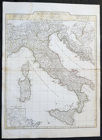
1764 J B D Anville Large Original Antique Map of Italy inset plan of Rome
- Title : Tabula Italiae Antiqua Geographica...MDCCLXIV
- Date : 1764
- Size: 29in x 21in (740mm x 535mm)
- Ref #: 92297
- Condition: (A+) Fine Condition
Description:
This large finely engraved and highly detailed original antique map of Italy by Jean Baptiste Bourguignon D\'Anville was engraved in 1764 - dated in the tile cartouche - and was published in Jean-Baptiste Bourguinon D\'Anville\'s large elephant folio atlas Atlas Generale.
General Definitions:
Paper thickness and quality: - Heavy and stable
Paper color : - off white
Age of map color: - Original
Colors used: - Yellow, green, pink, blue
General color appearance: - Authentic
Paper size: - 29in x 21in (740mm x 535mm)
Plate size: - 25in x 20in (635mm x 510mm)
Margins: - Min 1/2in (12mm)
Imperfections:
Margins: - Age toning along centerfold
Plate area: - Age toning along centerfold
Verso: - Age toning along centerfold
Background:
Since classical times, ancient Phoenicians, Carthaginians and Greeks established settlements in the south of Italy, with Etruscans and Celts inhabiting the centre and the north of Italy respectively and various ancient Italian tribes and Italic peoples dispersed throughout the Italian Peninsula and insular Italy. The Italic tribe known as the Latins formed the Roman Kingdom, which eventually became a republic that conquered and assimilated other nearby civilisations. Ultimately the Roman Empire emerged as the dominant power in the Mediterranean basin, conquering much of the ancient world and becoming the leading cultural, political and religious centre of Western civilisation. The legacy of the Roman Empire is widespread and can be observed in the global distribution of civilian law, republican governments, Christianity and the Latin script.
During the Early Middle Ages Italy suffered sociopolitical collapse amid calamitous barbarian invasions, but by the 11th century, numerous rival city-states and maritime republics, mainly in the northern and central regions of Italy, rose to great prosperity through shipping, commerce and banking, laying down the groundwork for modern capitalism.These mostly independent statelets, acting as Europe\'s main spice trade hubs with Asia and the Near East, often enjoyed a greater degree of democracy and wealth in comparison to the larger feudal monarchies that were consolidating throughout Europe at the time, though much of central Italy remained under the control of the theocratic Papal States, while Southern Italy remained largely feudal until the 19th century, partially as a result of a succession of Byzantine, Arab, Norman and Spanish conquests of the region.
The Renaissance began in Italy and spread to the rest of Europe, bringing a renewed interest in humanism, science, exploration and art. Italian culture flourished at this time, producing famous scholars, artists and polymaths such as Leonardo da Vinci, Galileo, Michelangelo and Machiavelli. Italian explorers such as Marco Polo, Christopher Columbus, Amerigo Vespucci and Giovanni da Verrazzano discovered new routes to the Far East and the New World, helping to usher in the European Age of Discovery. Nevertheless, Italy\'s commercial and political power significantly waned with the opening of the Atlantic trade route and the route to the Indian Ocean via the Cape of Good Hope, both of which bypassed the Mediterranean. Furthermore, the Italian city-states constantly engaged one another in bloody warfare, culminating in the Italian Wars of the 15th and 16th centuries that left them exhausted, with no one emerging as a dominant power. The weakened Italian sovereigns soon fell victim to conquest by European powers such as France, Spain and Austria.

1765 D Anville Large Antique Map of Egypt, Red Sea
- Title : Aegyptus Antiqua..Auctor D Anville...MDCCLXV (1765)
- Ref #: 92303
- Size: 22in x 15 1/2in (560mm x 395mm)
- Date : 1765
- Condition: (A) Very Good Condition
Description:
This large original antique map of Egypt - by Jean Baptiste Bourguignon D'Anville was engraved in 1765 - dated - and was published in D Anville's large elephant folio Atlas Generale.
The first separately printed map of Africa (as with the other known continents) appeared in Munster's Geographia from 1540 onwards and the first atlas devoted to Africa only was published in 1588 in Venice by Livio Sanuto, but the finest individual map of the century was that engraved on 8 sheets by Gastaldi, published in Venice in 1564. Apart from maps in sixteenth-century atlases generally there were also magnificent marine maps of 1596 by Jan van Linschoten (engraved by van Langrens) of the southern half of the continent with highly imaginative and decorative detail in the interior. In the next century there were many attractive maps including those of Mercator/Hondius (1606), Speed (1627), Blaeu (1 630), Visscher (1636), de Wit (c. 1670), all embellished with vignettes of harbours and principal towns and bordered with elaborate and colourful figures of their inhabitants, but the interior remained uncharted with the exception of that part of the continent known as Ethiopia, the name which was applied to a wide area including present-day Abyssinia. Here the legends of Prester John lingered on and, as so often happened in other remote parts of the world, the only certain knowledge of the region was provided by Jesuit missionaries. Among these was Father Geronimo Lobo (1595-1678), whose work A Voyage to Abyssinia was used as the basis for a remarkably accurate map published by a German scholar, Hiob Ludolf in 1683. Despite the formidable problems which faced them, the French cartographers G. Delisle (c. 1700-22), J. B. B. d'Anville (1727-49) and N. Bellin (1754) greatly improved the standards of mapping of the continent, improvements which were usually, although not always, maintained by Homann, Seutter, de Ia Rochette, Bowen, Faden and many others in the later years of the century. (Ref: Norwich; Tooley; M&B)
General Description:
Paper thickness and quality: - Heavy and stable
Paper color: - off white
Age of map color: -
Colors used: -
General color appearance: -
Paper size: - 22in x 15 1/2in (560mm x 395mm)
Plate size: - 20in x 13in (510mm x 330mm)
Margins: - Min 1in (25mm)
Imperfections:
Margins: - Light soiling
Plate area: - Light soiling
Verso: - Light soiling
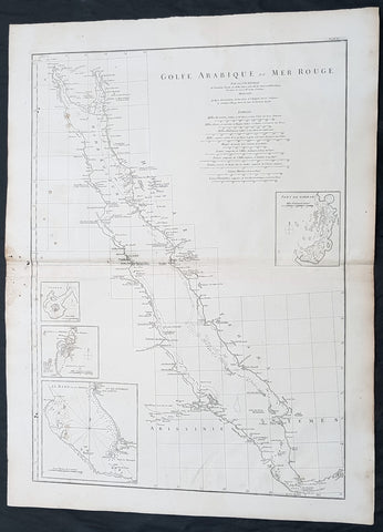
1765 D Anville Large Antique Map of The Red Sea, Saudi Arabia, Egypt & Yemen
- Title : Golfe Arabique ou Mer Rouge Par Le Sr D Anville....MDCCLXV
- Size: 29 1/2in x 22in (750mm x 560mm)
- Condition: (A) Very Good Condition
- Date : 1765
- Ref #: 92318
Description:
This large original copper plate engraved antique map of The Red Sea and the coasts of Saudi Arabia, Egypt & Yemen, was engraved in 1765 - dated in the tile cartouche - and was published in Jean-Baptiste Bourguinon D Anvilles large elephant folio atlas Atlas Generale.
General Definitions:
Paper thickness and quality: - Heavy and stable
Paper color : - off white
Age of map color: -
Colors used: -
General color appearance: -
Paper size: - 29 1/2in x 22in (750mm x 560mm)
Plate size: - 26 1/2in x 19in (675mm x 485mm)
Margins: - Min 1in (25mm)
Imperfections:
Margins: - Light soiling
Plate area: - Light soiling
Verso: - Light soling
Background:
Map depicts the Red Sea with coasts of Egypt, Sudan and the Arabian peninsula. 4 inset maps, 1. The city of Bur Sudan (Suakem), 2. The island Matzua and Arkiko in Sudan, 3. The harbour of Dschidda in Saudi-Arabia, 4. The strait of Bab-el-Mandeb with the island Perim.
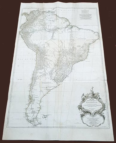
1768 D Anville Large Antique Map of South America
- Title : Amerique Meridionale Publiee Sous Les Auspices...Sr D Anville MDCCXLVIII
- Size: 55in x 32in (1.40m x 810mm)
- Condition: (A) Very Good Condition
- Date : 1768 (dated)
- Ref #: 92329
Description:
This very large original copper plate engraved antique map of South America was engraved in 1768 by William Delahaye - dated in the tile cartouche - and was published in Jean-Baptiste Bourguinon D Anvilles large elephant folio atlas Atlas Generale.
General Definitions:
Paper thickness and quality: - Heavy and stable
Paper color : - off white
Age of map color: -
Colors used: -
General color appearance: -
Paper size: - 55in x 32in (1.40m x 810mm)
Plate size: - 49in x 30 1/2in (1.30m x 770mm)
Margins: - Min 1in (25mm)
Imperfections:
Margins: - Creasing, light soiling
Plate area: - Creasing, light soiling
Verso: - Creasing, light soiling
Background:
In 1494, Portugal and Spain, the two great maritime European powers of that time, on the expectation of new lands being discovered in the west, signed the Treaty of Tordesillas, by which they agreed, with the support of the Pope, that all the land outside Europe should be an exclusive duopoly between the two countries.
The treaty established an imaginary line along a north-south meridian 370 leagues west of the Cape Verde Islands, roughly 46° 37W. In terms of the treaty, all land to the west of the line (known to comprise most of the South American soil) would belong to Spain, and all land to the east, to Portugal. As accurate measurements of longitude were impossible at that time, the line was not strictly enforced, resulting in a Portuguese expansion of Brazil across the meridian.
Beginning in the 1530s, the people and natural resources of South America were repeatedly exploited by foreign conquistadors, first from Spain and later from Portugal. These competing colonial nations claimed the land and resources as their own and divided it in colonies.
European infectious diseases (smallpox, influenza, measles, and typhus) – to which the native populations had no immune resistance – caused large-scale depopulation of the native population under Spanish control. Systems of forced labor, such as the haciendas and mining industrys mita also contributed to the depopulation. After this, African slaves, who had developed immunities to these diseases, were quickly brought in to replace them.
The Spaniards were committed to converting their native subjects to Christianity and were quick to purge any native cultural practices that hindered this end; however, many initial attempts at this were only partially successful, as native groups simply blended Catholicism with their established beliefs and practices. Furthermore, the Spaniards brought their language to the degree they did with their religion, although the Roman Catholic Churchs evangelization in Quechua, Aymara, and Guaraní actually contributed to the continuous use of these native languages albeit only in the oral form.
Eventually, the natives and the Spaniards interbred, forming a mestizo class. At the beginning, many mestizos of the Andean region were offspring of Amerindian mothers and Spanish fathers. After independence, most mestizos had native fathers and European or mestizo mothers.
Many native artworks were considered pagan idols and destroyed by Spanish explorers; this included many gold and silver sculptures and other artifacts found in South America, which were melted down before their transport to Spain or Portugal. Spaniards and Portuguese brought the western European architectural style to the continent, and helped to improve infrastructures like bridges, roads, and the sewer system of the cities they discovered or conquered. They also significantly increased economic and trade relations, not just between the old and new world but between the different South American regions and peoples. Finally, with the expansion of the Portuguese and Spanish languages, many cultures that were previously separated became united through that of Latin American.
Guyana was first a Dutch, and then a British colony, though there was a brief period during the Napoleonic Wars when it was colonized by the French. The country was once partitioned into three parts, each being controlled by one of the colonial powers until the country was finally taken over fully by the British.
The European Peninsular War (1807–1814), a theater of the Napoleonic Wars, changed the political situation of both the Spanish and Portuguese colonies. First, Napoleon invaded Portugal, but the House of Braganza avoided capture by escaping to Brazil. Napoleon also captured King Ferdinand VII of Spain, and appointed his own brother instead. This appointment provoked severe popular resistance, which created Juntas to rule in the name of the captured king.
Many cities in the Spanish colonies, however, considered themselves equally authorized to appoint local Juntas like those of Spain. This began the Spanish American wars of independence between the patriots, who promoted such autonomy, and the royalists, who supported Spanish authority over the Americas. The Juntas, in both Spain and the Americas, promoted the ideas of the Enlightenment. Five years after the beginning of the war, Ferdinand VII returned to the throne and began the Absolutist Restoration as the royalists got the upper hand in the conflict.
The independence of South America was secured by Simón Bolívar (Venezuela) and José de San Martín (Argentina), the two most important Libertadores. Bolívar led a great uprising in the north, then led his army southward towards Lima, the capital of the Viceroyalty of Peru. Meanwhile, San Martín led an army across the Andes Mountains, along with Chilean expatriates, and liberated Chile. He organized a fleet to reach Peru by sea, and sought the military support of various rebels from the Vice-royalty of Peru. The two armies finally met in Guayaquil, Ecuador, where they cornered the Royal Army of the Spanish Crown and forced its surrender.
In the Portuguese Kingdom of Brazil, Dom Pedro I (also Pedro IV of Portugal), son of the Portuguese King Dom João VI, proclaimed the independent Kingdom of Brazil in 1822, which later became the Empire of Brazil. Despite the Portuguese loyalties of garrisons in Bahia, Cisplatina and Pará, independence was diplomatically accepted by the crown in Portugal in 1825, on condition of a high compensation paid by Brazil mediatized by the United Kingdom.
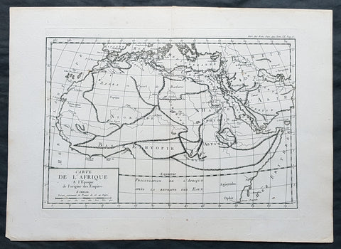
1769 J B D Anville Original Antique Map of Africa as known to the Ancients
- Title : Carte De L Afrique a l Epoque de l origine des Empires
- Size: 16in x 11in (410mm x 260mm)
- Ref #: 32341
- Date : 1769
- Condition: (A+) Fine Condition
Description:
This fine large, original copper-plate engraved antique map was published by Jean Baptiste Bourguignon D\'Anville in the 1769 edition of his atlas Geographie Ancienne et Abregee. or Modern and Ancient Geography (Ref: M&B; Tooley)
General Definitions:
Paper thickness and quality: - Heavy and stable
Paper color : - off white
Age of map color: -
Colors used: -
General color appearance: -
Paper size: - 16in x 11in (410mm x 260mm)
Plate size: - 13in x 9 1/2in (330mm x 245mm)
Margins: - Min 1/2in (12mm)
Imperfections:
Margins: - None
Plate area: - None
Verso: - None
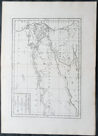
1769 J B D Anville Original Antique Map of Egypt & The Nile in Time of Pharaohs
- Title : Carte De L Egypte sous Les Pharaons
- Size: 16in x 11in (410mm x 260mm)
- Ref #: 32342
- Date : 1769
- Condition: (A+) Fine Condition
Description:
This fine large, original copper-plate engraved antique map was published by Jean Baptiste Bourguignon D'Anville in the 1769 edition of his atlas Geographie Ancienne et Abregee. or Modern and Ancient Geography (Ref: M&B; Tooley)
General Definitions:
Paper thickness and quality: - Heavy and stable
Paper color : - off white
Age of map color: -
Colors used: -
General color appearance: -
Paper size: - 16in x 11in (410mm x 260mm)
Plate size: - 13in x 9 1/2in (330mm x 245mm)
Margins: - Min 1/2in (12mm)
Imperfections:
Margins: - None
Plate area: - None
Verso: - None

1769 J B D Anville Original Antique Map of Greece Crete Macedonia Turkey Cyprus
- Title : Carte Generale De La Grece
- Size: 16in x 11in (410mm x 260mm)
- Ref #: 32345
- Date : 1769
- Condition: (A+) Fine Condition
Description:
This fine large, original copper-plate engraved antique map was published by Jean Baptiste Bourguignon D\'Anville in the 1769 edition of his atlas Geographie Ancienne et Abregee. or Modern and Ancient Geography (Ref: M&B; Tooley)
General Definitions:
Paper thickness and quality: - Heavy and stable
Paper color : - off white
Age of map color: -
Colors used: -
General color appearance: -
Paper size: - 16in x 11in (410mm x 260mm)
Plate size: - 13in x 9 1/2in (330mm x 245mm)
Margins: - Min 1/2in (12mm)
Imperfections:
Margins: - None
Plate area: - None
Verso: - None
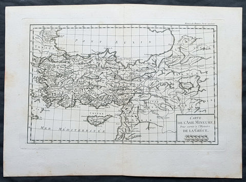
1769 J B D Anville Original Antique Map of Turkey, Cyprus, Asia Minor, Syria
- Title : Carte De L Asie Minerure Pour Servir a L Histoire De La Grece
- Size: 16in x 11in (410mm x 260mm)
- Ref #: 32346
- Date : 1769
- Condition: (A+) Fine Condition
Description:
This fine large, original copper-plate engraved antique map was published by Jean Baptiste Bourguignon D\'Anville in the 1769 edition of his atlas Geographie Ancienne et Abregee. or Modern and Ancient Geography (Ref: M&B; Tooley)
General Definitions:
Paper thickness and quality: - Heavy and stable
Paper color : - off white
Age of map color: -
Colors used: -
General color appearance: -
Paper size: - 16in x 11in (410mm x 260mm)
Plate size: - 13in x 9 1/2in (330mm x 245mm)
Margins: - Min 1/2in (12mm)
Imperfections:
Margins: - None
Plate area: - None
Verso: - None
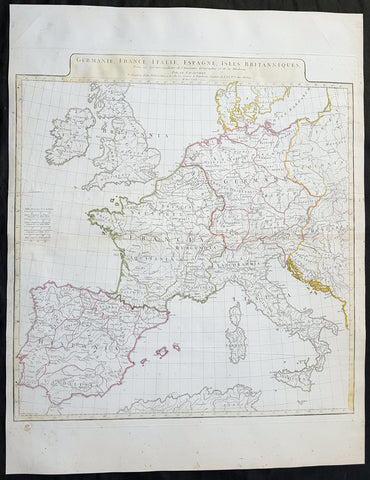
1771 J B D Anville Large Original Antique Map of Western Europe & Britain
- Title : Germanie, France, Italie, Espagne, Isles Britanniques...MDCCLXXI
- Size: 25 1/2in x 20in (650mm x 525mm)
- Ref #: 92305
- Date : 1771
- Condition: (A) Very Good Condition
Description:
This large finely engraved and highly detailed original antique map of Western Europe and The British Isles by Jean Baptiste Bourguignon D\'Anville was engraved in 1771 - dated in the tile cartouche - and was published in Jean-Baptiste Bourguinon D\'Anville\'s large elephant folio atlas Atlas Generale.
General Definitions:
Paper thickness and quality: - Heavy and stable
Paper color : - off white
Age of map color: - Original
Colors used: - Yellow
General color appearance: - Authentic
Paper size: - 25 1/2in x 20in (650mm x 525mm)
Plate size: - 21in x 19 1/2in (535mm x 495mm)
Margins: - Min 1/2in (12mm)
Imperfections:
Margins: - Creasing along centerfold
Plate area: - Creasing along centerfold
Verso: - Creasing along centerfold
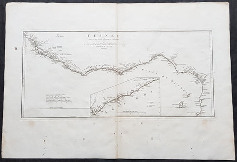
1775 J B D Anville Large Antique Map Gulf of Guinea West Africa Liberia to Gabon
- Title : Guinee Ent Serre-Lione et le pasage de la Ligne par le S D\'Anville...MDCCLXXV (1775)
- Size: 31in x 21 1/2in (790mm x 550mm)
- Condition: (A) Very Good Condition
- Date : 1775
- Ref #: 92325
Description:
This large original copper-plate engraved antique map of The Gulf Of Guinea, West Africa from Liberia to Gabon by Jean Baptiste Bourguignon D\'Anville was engraved in 1775 - dated in the tile cartouche - and was published in Jean-Baptiste Bourguinon D\'Anvilles large elephant folio atlas Atlas Generale.
(Ref: Tooley, M&B)
General Definitions:
Paper thickness and quality: - Heavy and stable
Paper color : - off white
Age of map color: -
Colors used: -
General color appearance: -
Paper size: - 31in x 21 1/2in (790mm x 550mm)
Plate size: - 21in x 19 1/2in (670mm x 320mm)
Margins: - Min 2in (50mm)
Imperfections:
Margins: - Light soiling in margins, small worm holes in bottom margin
Plate area: - None
Verso: - Light soiling
Background:
Being part of the Mediterranean world, the northern coasts of the African continent as far as the Straits of Gibraltar and even round to the area of the Fortunate Isles (the Canaries) were reasonably well known and quite accurately mapped from ancient times. In particular, Egypt and the Nile Valley were well defined and the Nile itself was, of course, one of the rivers separating the continents in medieval T-O maps. Through Arab traders the shape of the east coast, down the Red Sea as far as the equator, was also known but detail shown in the interior faded into deserts with occasional mountain ranges and mythical rivers. The southern part of the continent, in the Ptolemaic tradition, was assumed to curve to the east to form a land-locked Indian Ocean. The voyages of the Portuguese, organized by Henry the Navigator in the fifteenth century, completely changed the picture and by the end of the century Vasco da Gama had rounded the Cape enabling cartographers to draw a quite presentable coastal outline of the whole continent, even if the interior was to remain largely unknown for the next two or three centuries.
The first separately printed map of Africa (as with the other known continents) appeared in Munster\\\'s Geographia from 1540 onwards and the first atlas devoted to Africa only was published in 1588 in Venice by Livio Sanuto, but the finest individual map of the century was that engraved on 8 sheets by Gastaldi, published in Venice in 1564. Apart from maps in sixteenth-century atlases generally there were also magnificent marine maps of 1596 by Jan van Linschoten (engraved by van Langrens) of the southern half of the continent with highly imaginative and decorative detail in the interior. In the next century there were many attractive maps including those of Mercator/Hondius (1606), Speed (1627), Blaeu (1 630), Visscher (1636), de Wit (c. 1670), all embellished with vignettes of harbours and principal towns and bordered with elaborate and colourful figures of their inhabitants, but the interior remained uncharted with the exception of that part of the continent known as Ethiopia, the name which was applied to a wide area including present-day Abyssinia. Here the legends of Prester John lingered on and, as so often happened in other remote parts of the world, the only certain knowledge of the region was provided by Jesuit missionaries. Among these was Father Geronimo Lobo (1595-1678), whose work A Voyage to Abyssinia was used as the basis for a remarkably accurate map published by a German scholar, Hiob Ludolf in 1683. Despite the formidable problems which faced them, the French cartographers G. Delisle (c. 1700-22), J. B. B. d\\\'Anville (1727-49) and N. Bellin (1754) greatly improved the standards of mapping of the continent, improvements which were usually, although not always, maintained by Homann, Seutter, de Ia Rochette, Bowen, Faden and many others in the later years of the century.
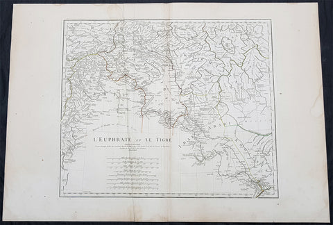
1779 J B D Anville Large Antique Map of the Tigris–Euphrates River System Iraq
- Title : L Euphrate et Le Tigre Par Le Sr D Anville..MDCCLXXIX
- Size: 30in x 21in (760mm x 535mm)
- Condition: (A) Very Good Condition
- Date : 1779
- Ref #: 92300
Description:
This large original copper plate engraved antique map of the Tigris–Euphrates river system was engraved in 1779 - dated in the tile cartouche - and was published in Jean-Baptiste Bourguinon D Anvilles large elephant folio atlas Atlas Generale.
General Definitions:
Paper thickness and quality: - Heavy and stable
Paper color : - off white
Age of map color: - Original
Colors used: - Yellow, Green, pink
General color appearance: - Authentic
Paper size: - 30in x 21in (760mm x 535mm)
Plate size: - 21in x 17 1/2in (535mm x 430mm)
Margins: - Min 1/2in (12mm)
Imperfections:
Margins: - Creasing, light age toning
Plate area: - Creasing
Verso: - Creasing, light age toning
Background:
The Tigris and Euphrates, with their tributaries, form a major river system in Western Asia. From sources originating in eastern Turkey, they flow by/through Syria through Iraq into the Persian Gulf. The system is part of the Palearctic Tigris–Euphrates ecoregion, which includes Iraq and parts of Turkey, Syria, Iran, Saudi Arabia, Kuwait, and Jordan.
From their sources and upper courses in the mountains of eastern Anatolia, the rivers descend through valleys and gorges to the uplands of Syria and northern Iraq and then to the alluvial plain of central Iraq. The rivers flow in a south-easterly direction through the central plain and combine at Al-Qurnah to form the Shatt al-Arab and discharge into the Persian Gulf.
The region has historical importance as part of the Fertile Crescent region, in which civilization is believed to have first emerged.
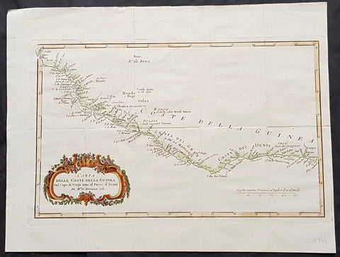
1781 J B D Anville Antique Map Gulf Of Guinea, West Africa - Liberia to Nigeria
- Title : Carta Delle Coste Della Guinea...1781
- Size: 15in x 11 1/2in (380mm x 290mm)
- Condition: (A+) Fine Condition
- Date : 1781
- Ref #: 15620
Description:
This magnificent original hand coloured copper-plate engraved antique map of The Gulf Of Guinea from Liberia to Nigeria by Jean Baptiste Bourguignon D\'Anville in 1781 - dated. (Ref: M&B; Tooley)
General Definitions:
Paper thickness and quality: - Heavy and stable
Paper color : - off white
Age of map color: -
Colors used: -
General color appearance: -
Paper size: - 15in x 11 1/2in (380mm x 290mm)
Plate size: - 13 1/2in x 8 1/2in (345mm x 220mm)
Margins: - Min 1/2in (12mm)
Imperfections:
Margins: - None
Plate area: - Folds as issued
Verso: - None
Background:
Being part of the Mediterranean world, the northern coasts of the African continent as far as the Straits of Gibraltar and even round to the area of the Fortunate Isles (the Canaries) were reasonably well known and quite accurately mapped from ancient times. In particular, Egypt and the Nile Valley were well defined and the Nile itself was, of course, one of the rivers separating the continents in medieval T-O maps. Through Arab traders the shape of the east coast, down the Red Sea as far as the equator, was also known but detail shown in the interior faded into deserts with occasional mountain ranges and mythical rivers. The southern part of the continent, in the Ptolemaic tradition, was assumed to curve to the east to form a land-locked Indian Ocean. The voyages of the Portuguese, organized by Henry the Navigator in the fifteenth century, completely changed the picture and by the end of the century Vasco da Gama had rounded the Cape enabling cartographers to draw a quite presentable coastal outline of the whole continent, even if the interior was to remain largely unknown for the next two or three centuries.
The first separately printed map of Africa (as with the other known continents) appeared in Munster\\\'s Geographia from 1540 onwards and the first atlas devoted to Africa only was published in 1588 in Venice by Livio Sanuto, but the finest individual map of the century was that engraved on 8 sheets by Gastaldi, published in Venice in 1564. Apart from maps in sixteenth-century atlases generally there were also magnificent marine maps of 1596 by Jan van Linschoten (engraved by van Langrens) of the southern half of the continent with highly imaginative and decorative detail in the interior. In the next century there were many attractive maps including those of Mercator/Hondius (1606), Speed (1627), Blaeu (1 630), Visscher (1636), de Wit (c. 1670), all embellished with vignettes of harbours and principal towns and bordered with elaborate and colourful figures of their inhabitants, but the interior remained uncharted with the exception of that part of the continent known as Ethiopia, the name which was applied to a wide area including present-day Abyssinia. Here the legends of Prester John lingered on and, as so often happened in other remote parts of the world, the only certain knowledge of the region was provided by Jesuit missionaries. Among these was Father Geronimo Lobo (1595-1678), whose work A Voyage to Abyssinia was used as the basis for a remarkably accurate map published by a German scholar, Hiob Ludolf in 1683. Despite the formidable problems which faced them, the French cartographers G. Delisle (c. 1700-22), J. B. B. d\\\'Anville (1727-49) and N. Bellin (1754) greatly improved the standards of mapping of the continent, improvements which were usually, although not always, maintained by Homann, Seutter, de Ia Rochette, Bowen, Faden and many others in the later years of the century.

1782 J B D Anville Large Antique Map of Western Roman Europe, Britain to Italy
- Title : Germanie, France, Italie, Espagne, Isles Britanniques...Par Le Sr D Anville...MDCCLXXXII
- Size: 27in x 20in (585mm x 510mm)
- Condition: (A) Very Good Condition
- Date : 1782
- Ref #: 92646
Description:
This large hand coloured original copper-plate engraved antique map of Western Roman Britain by Jean Baptiste Bourguignon D\'Anville was engraved in 1782 - dated in the tile cartouche - and was published in Jean-Baptiste Bourguinon D\'Anvilles large elephant folio atlas Atlas Generale. (Ref: Tooley, M&B)
General Definitions:
Paper thickness and quality: - Heavy and stable
Paper color : - off white
Age of map color: -
Colors used: -
General color appearance: -
Paper size: - 27in x 20in (585mm x 510mm)
Plate size: - 21in x 19 1/2in (535mm x 495mm)
Margins: - Min 1in (25mm)
Imperfections:
Margins: - None
Plate area: - Vertical & horizontal folds
Verso: - None
Background:
The Roman Empire was the post-Roman Republic period of the ancient Roman civilization, with a government headed by emperors and large territorial holdings around the Mediterranean Sea in Europe, Africa and Asia. The city of Rome was the largest city in the world c. 100 BC – c. AD 400, with Constantinople (New Rome) becoming the largest around AD 500, and the Empire\'s population grew to an estimated 50 to 90 million inhabitants (roughly 20% of the world\'s population at the time) The 500-year-old republic which preceded it had been severely destabilized in a series of civil wars and political conflict, during which Julius Caesar was appointed as perpetual dictator and then assassinated in 44 BC. Civil wars and executions continued, culminating in the victory of Octavian, Caesar\'s adopted son, over Mark Antony and Cleopatra at the Battle of Actium in 31 BC and the annexation of Egypt. Octavian\'s power was then unassailable and in 27 BC the Roman Senate formally granted him overarching power and the new title Augustus, effectively marking the end of the Roman Republic.
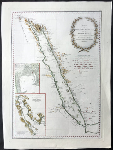
1787 D Anville & Niebuhr V. Large Antique Map of The Red Sea Suez, Saudi Arabia
- Title : Karte des Arabischen Meerbusens oder des Rothen Meeres...MDCCLXXXVII (1787)
- Ref #: 61154
- Size: 31in x 23in (790mm x 585mm)
- Date : 1787
- Condition: (A+) Fine Condition
Description:
This very large, handsome original antique map of the Red Sea, with original decorative colour, from the town of Suez in the north to the Persian Gulf by Jean Baptiste Bourguignon D'Anville, after Carsten Niebuhr, was engraved by Henri Benedicti (in 1787, dated in title) and published by Franz Anton Schraembl (1751-1803) in his large scale Allgemeiner grosser Atlas.
The map is testimony to German cartography & engraving, both beautifully executed with superb original hand colouring. The map is adorned with inset maps of the Gulf of Suez and another scaled map of the Red Sea.
Background: The original author of this map Carsten Niebuhr (1733 - 1815) was a German born mathematician who lived in Denmark from 1760. In 1761 he was sent on a scientific expedition sponsored by Frederick V of Denmark to Egypt, Arabia and Syria together with five other scientists.
Niebuhr was the only one to survive the Danish, Arabic expedition. He returned to Copenhagen in 1767 and published the new discoveries in 1773 in 'Beschreibung von Arabien'. The work was followed with two other volumes with descriptions and maps of Arabian Peninsula in both 1774 and 1778. (Ref: Norwich; Tooley; M&B)
General Description:
Paper thickness and quality: - Heavy and stable
Paper color: - off white
Age of map color: - Original
Colors used: - Green, yellow, red, brown
General color appearance: - Original
Paper size: - 31in x 23in (790mm x 585mm)
Plate size: - 27 1/2in x 19 3/4in (700mm x 500mm)
Margins: - Min 2in (50mm)
Imperfections:
Margins: - None
Plate area: - None
Verso: - None
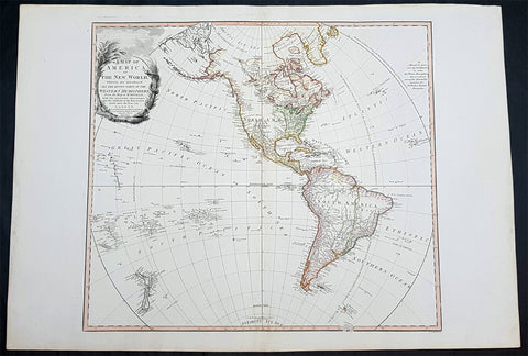
1797 William Faden & D Anville Large Antique Map of America - Western Hemisphere, NZ
- Title : A Map of America or the New World, wherein are introduced all the known parts of the Western Hemisphere From the Map of d'Anville with the necessary alterations and the addition of the Discoveries made since the Year 1761. London: W. Faden 1797.
- Ref #: 61144
- Size: 33in x 23in (840mm x 585mm)
- Date : 1797
- Condition: (A+) Fine Condition
Description:
This very large, beautifully hand coloured original 1st edition scarce antique map of America & The Western Hemisphere with New Zealand was engraved by William Palmer in 1797 - date engraved in the title cartouche - and was published by William Faden in his General Atlas, London.
Background: This is the first state of Faden's large beautiful map of America within the Western Hemisphere after D Anville, with the words O Rare Columbus included within the title cartouche, paying homage to Christopher Columbus.
The map illustrates the discoveries of Captains Cook & La Perouse along the NW Coast of America and throughout the Pacific, including the Sandwich Islands during the mid to late 8th century.
Pope Alexander's 1493 Line of Demarcation is shown in the Atlantic, separating the Portuguese and Spanish possessions. The Antarctic Icy Sea is noted, along with a note reading Cook's Nec Plus Ultra 71 Degrees 10 Minutes Latitude South January 30th 1774.
While the Bay of the West is not shown, there is an annotation in the Northwest which reads A'ASS TOPULSE or GREAT SEA of the Indians SEA of THE WEST of the Geographers. The Arctic Icy Sea or Hyperborean Sea is named.
Excellent detail along the Northwest Passage, with several additional annotations, along with several discoveries and exploration annotation's appearing in the Pacific and Atlantic Oceans. Attractive engraved cartouche. (Ref Tooley M&B)
General Description:
Paper thickness and quality: - Heavy and stable
Paper color: - off white
Age of map color: - Original
Colors used: - Pink, blue, yellow, green
General color appearance: - Authentic
Paper size: - 33in x 23in (840mm x 585mm)
Plate size: - 24in x 21 1/2in (610mm x 545mm)
Margins: - Min 1in (25mm)
Imperfections:
Margins: - None
Plate area: - None
Verso: - None