Welcome to Classical Images!
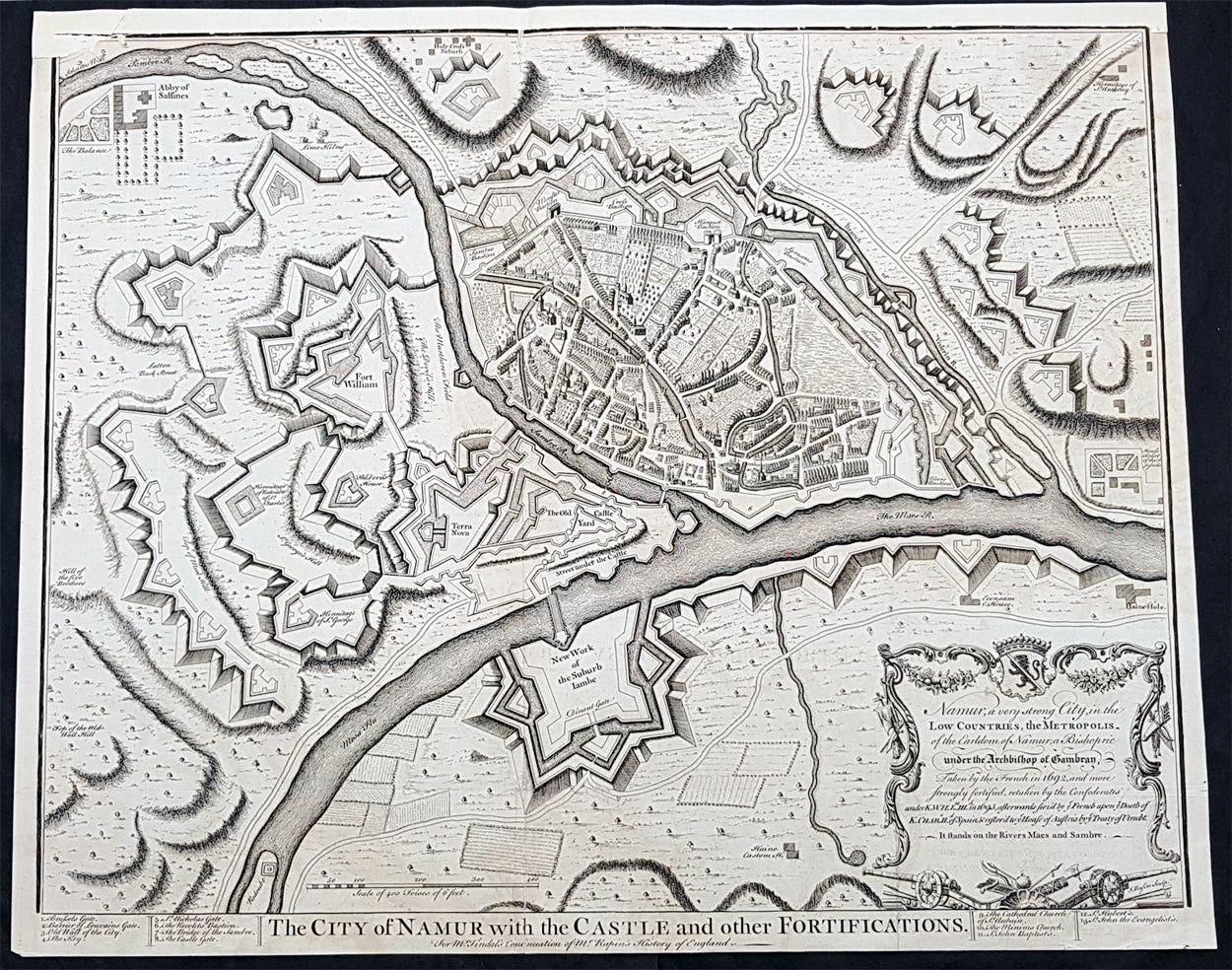
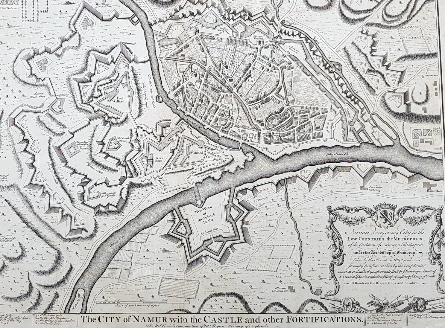
Description:This original copper-plate engraved antique map a Bird Eye View of the city of Namur, Belgium - during the Spanish War of Succession (1701-13) - was engraved by John Basire and was published in the 1745 edition of Nicholas Tindals Continuation of Mr. Rapins History of England.
General Definitions:Paper thickness and quality: - Heavy and stablePaper color : - off whiteAge of map color: -Colors used: -General color appearance: -Paper size: - 19 1/2in x 15 1/2in (495mm x 395mm)Plate size: - 19 1/2in x 15 1/2in (495mm x 395mm)Margins: - Min 1/2in (12mm)
Imperfections:Margins: - Top margin restoredPlate area: - Small loss to left of imageVerso: - Folds as issued
Background: Mons is a Walloon city and municipality, and the capital of the Belgian province of Hainaut. The Mons municipality includes the former communes of Cuesmes, Flénu, Ghlin, Hyon, Nimy, Obourg, Jemappes, Ciply, Harmignies, Harveng, Havré, Maisières, Mesvin, Nouvelles, Saint-Denis, Saint-Symphorien, Spiennes and Villers-Saint-Ghislain.Mons was made into a fortified city by Count Baldwin IV of Hainaut in the 12th century. The population grew quickly, trade flourished, and several commercial buildings were erected near the GrandPlace. In 1814, King William I of the Netherlands increased the fortifications, following the fall of the First French Empire. The Industrial Revolution and coal mining made Mons a center of heavy industry. In 1830, Belgium gained its independence and the decision was made to dismantle the fortifications, allowing the creation of large boulevards and other urban projects.In 1515, Charles V took an oath in Mons as Count of Hainaut. In this period of its history, the city became the target of various occupations, starting in May 1572 with the Protestant takeover by Louis of Nassau, who had hoped to clear the way for the French Protestant leader Gaspard de Coligny to oppose Spanish rule. After the murder of de Coligny during the St. Bartholomews Day massacre, the Duke of Alba took control of Mons in September 1572 in the name of the Catholic King of Spain. This spelled the ruin of the city and the arrest of many of its inhabitants; from 1580 to 1584, Mons became the capital of the Southern Netherlands.On 8 April 1691, after a nine-month siege, Louis XIVs army stormed the city, which again suffered heavy casualties. From 1697 to 1701, Mons was alternately French or Austrian. After being under French control from 1701 to 1709, the Dutch army gained the upper hand in the Battle of Malplaquet. In 1715, Mons returned to Austria under the terms of the Treaty of Utrecht (1713). But the French did not give up easily; Louis XV besieged the city again in 1746. After the Battle of Jemappes (1792), the Hainaut area was annexed to France and Mons became the capital of the Jemappes district.Following the fall of the First French Empire in 1814, King William I of the Netherlands fortified the city heavily. In 1830, however, Belgium gained its independence and the decision was made to dismantle fortified cities such as Mons, Charleroi, and Namur. The actual removal of fortifications only happened in the 1860s, allowing the creation of large boulevards and other urban projects. The Industrial Revolution and coal mining made Mons a center of heavy industry, which strongly influenced the culture and image of the Borinage region as a whole. It was to become an integral part of the sillon industriel, the industrial backbone of Wallonia.