Welcome to Classical Images!
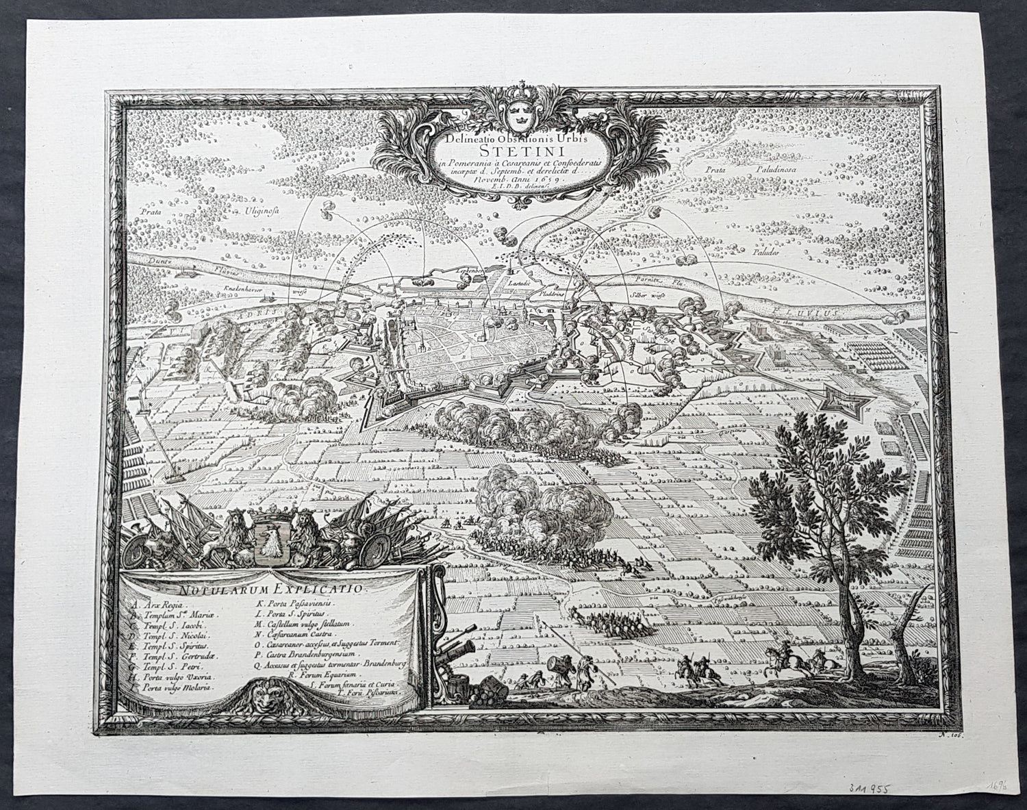
Description:This original copper plate engraved antique map a birds eye view of the 1659 siege of Szczecin or Stettin, then located in Germany, now Poland by Count Erik Dahlbergh was published by Samuel Freiherr von Pufendorf (1632 - 1694) in the 1684 edition of Einleitung zu der Historie der vornehmsten Reiche und Staaten, so itziger Zeit in Europa sich befindenDuring the Thirty Years War, Stettin refused to accept German imperial armies, instead the Pomeranian dukes allied with Sweden. After the Treaty of Stettin (1630) manifested Swedish occupation, Stettin was fortified by the Swedish Empire. After the death of the last Pomeranian duke, Boguslaw XIV, Stettin was awarded to Sweden with the western part of the duchy in the Peace of Westphalia (1648), but remained part of the Holy Roman Empire. The Swedish-Brandenburgian border was settled in the Treaty of Stettin (1653). The King of Sweden became Duke of Pomerania and as such held a seat in the Imperial Diet of the Holy Roman Empire. The city was cut off from its main trading area, and was besieged in several wars with Brandenburg which shattered the citys economy, which fell in prolonged economic decline.In 1654 the last Pomeranian duke Boguslaw XIV was buried in the Ducal Castle.
General Definitions:Paper thickness and quality: - Heavy and stablePaper color : - off whiteAge of map color: -Colors used: -General color appearance: -Paper size: - 17in x 14in (430mm x 355mm)Plate size: - 15 1/2in x 11 1/2in (395mm x 300mm)Margins: - Min 1/2in (12mm)
Imperfections:Margins: - NonePlate area: - NoneVerso: - None
Background:Szczecin is located on the river Oder, south of the Szczecin Lagoon and the Bay of Pomerania. The city is situated along the southwestern shore of Dąbie Lake, on both sides of the Oder and on several large islands between the western and eastern branches of the river. Szczecin is adjacent to the town of Police and is the urban centre of the Szczecin agglomeration, an extended metropolitan area that includes communities in the German states of Brandenburg and Mecklenburg-Vorpommern.The cities recorded history began in the 8th century as a Lechitic Pomeranian stronghold, built at the site of the Ducal castle. In the 12th century, when Szczecin had become one of Pomeranias main urban centres, it lost its independence to Piast Poland, the Duchy of Saxony, the Holy Roman Empire and Denmark. At the same time, the House of Griffins established themselves as local rulers and the population was Christianized. After the Treaty of Stettin in 1630, the town came under the control of the Swedish Empire and became in 1648 the Capital of Swedish Pomerania until 1720, when it was acquired by the Kingdom of Prussia and then the German Empire. Following World War II Stettin became part of Poland in accordance with the Potsdam Agreement, resulting in the almost complete expulsion of the pre-war German population.
Dahlbergh, Erik Jonsson 1625 1703Count Erik Jonsson Dahlbergh (10 October 1625 – 16 January 1703) was a Swedish military engineer, Governor-general and Field marshal. He rose to the level of nobility through his military competence. As an architect and draftsman, he was renowned for fortification works. He is most known for his collection of engravings Suecia Antiqua et Hodierna, a collection of engravings of topographical research.Erik Dahlbergh was born in Stockholm, Sweden. His early studies involved the science of fortification. Orphaned at an early age, Dahlberghs studies qualified him as a scribe and in 1641 he found employment in Hamburg with Gerdt Rehnskiöld (1610−1658), senior accountant for Pommern and Mecklenburg. Over a six year period, he was taught the fundamentals in draughtsmanship. While learning these skills, he also studied mathematics, architecture, perspective and map drawing.He saw service as an engineer officer during the latter years of the Thirty Years War. In 1650, the military command dispatched Dahlbergh to Frankfurt to recoup war indemnity awarded to Sweden following the Treaty of Westphalia. Dahlbergh also contacted the publishing firm of Merian and provided topographical maps.While studying art in Italy, news reached him of a coming war between Sweden and Poland-Lithuania and he saw the potential for a military career. In his military career, Dahlbergh saw service in Poland as adjutant-general and engineering adviser to Charles X of Sweden. He participated in March across the Belts and at the sieges of Copenhagen and Kronborg where he directed the engineers during the Northern Wars.In spite of his distinguished service, Dahlbergh remained a lieutenant-colonel for many years. His talents were later recognized and in 1676, he became director-general of fortifications for the Swedish crown. As director, Dahlbergh rendered distinguished service over the next twenty-five years.At Helsingborg in 1677, he was a key operative in the Great Northern War at Dunamünde, and in 1700 he was instrumental in the defense of the two sieges of Riga. His work in repairing the fortresses of his own country earned for him the title of the Vauban of Sweden. He was also the founder of the Swedish engineer corps. He retired while in the rank of field marshal in 1702 and died the following year.