Erik Jonsson Dahlbergh
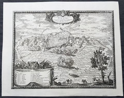
1682 Dahlbergh Antique Map Birds Eye View Szczecin or Stettin Poland, Siege 1659
- Title : Delineatio Obsidionis Urbis Stetini in Pomerania à Cesareanis et Confoederatis incaeptae d. Septemb. et derelictae d. ... Novemb. Anni 1659 / E. I. D. B. delinea.
- Ref #: 93496
- Size: 17in x 14in (430mm x 355mm)
- Date : 1684
- Condition: (A+) Fine Condition
Description:
This original copper plate engraved antique map a birds eye view of the 1659 siege of Szczecin or Stettin, then located in Germany, now Poland by Count Erik Dahlbergh was published by Samuel Freiherr von Pufendorf (1632 - 1694) in the 1684 edition of Einleitung zu der Historie der vornehmsten Reiche und Staaten, so itziger Zeit in Europa sich befinden
During the Thirty Years War, Stettin refused to accept German imperial armies, instead the Pomeranian dukes allied with Sweden. After the Treaty of Stettin (1630) manifested Swedish occupation, Stettin was fortified by the Swedish Empire. After the death of the last Pomeranian duke, Boguslaw XIV, Stettin was awarded to Sweden with the western part of the duchy in the Peace of Westphalia (1648), but remained part of the Holy Roman Empire. The Swedish-Brandenburgian border was settled in the Treaty of Stettin (1653). The King of Sweden became Duke of Pomerania and as such held a seat in the Imperial Diet of the Holy Roman Empire. The city was cut off from its main trading area, and was besieged in several wars with Brandenburg which shattered the citys economy, which fell in prolonged economic decline.
In 1654 the last Pomeranian duke Boguslaw XIV was buried in the Ducal Castle.
General Definitions:
Paper thickness and quality: - Heavy and stable
Paper color : - off white
Age of map color: -
Colors used: -
General color appearance: -
Paper size: - 17in x 14in (430mm x 355mm)
Plate size: - 15 1/2in x 11 1/2in (395mm x 300mm)
Margins: - Min 1/2in (12mm)
Imperfections:
Margins: - None
Plate area: - None
Verso: - None
Background:
Szczecin is located on the river Oder, south of the Szczecin Lagoon and the Bay of Pomerania. The city is situated along the southwestern shore of Dąbie Lake, on both sides of the Oder and on several large islands between the western and eastern branches of the river. Szczecin is adjacent to the town of Police and is the urban centre of the Szczecin agglomeration, an extended metropolitan area that includes communities in the German states of Brandenburg and Mecklenburg-Vorpommern.
The cities recorded history began in the 8th century as a Lechitic Pomeranian stronghold, built at the site of the Ducal castle. In the 12th century, when Szczecin had become one of Pomeranias main urban centres, it lost its independence to Piast Poland, the Duchy of Saxony, the Holy Roman Empire and Denmark. At the same time, the House of Griffins established themselves as local rulers and the population was Christianized. After the Treaty of Stettin in 1630, the town came under the control of the Swedish Empire and became in 1648 the Capital of Swedish Pomerania until 1720, when it was acquired by the Kingdom of Prussia and then the German Empire. Following World War II Stettin became part of Poland in accordance with the Potsdam Agreement, resulting in the almost complete expulsion of the pre-war German population.
Dahlbergh, Erik Jonsson 1625 1703
Count Erik Jonsson Dahlbergh (10 October 1625 – 16 January 1703) was a Swedish military engineer, Governor-general and Field marshal. He rose to the level of nobility through his military competence. As an architect and draftsman, he was renowned for fortification works. He is most known for his collection of engravings Suecia Antiqua et Hodierna, a collection of engravings of topographical research.
Erik Dahlbergh was born in Stockholm, Sweden. His early studies involved the science of fortification. Orphaned at an early age, Dahlberghs studies qualified him as a scribe and in 1641 he found employment in Hamburg with Gerdt Rehnskiöld (1610−1658), senior accountant for Pommern and Mecklenburg. Over a six year period, he was taught the fundamentals in draughtsmanship. While learning these skills, he also studied mathematics, architecture, perspective and map drawing.
He saw service as an engineer officer during the latter years of the Thirty Years War. In 1650, the military command dispatched Dahlbergh to Frankfurt to recoup war indemnity awarded to Sweden following the Treaty of Westphalia. Dahlbergh also contacted the publishing firm of Merian and provided topographical maps.
While studying art in Italy, news reached him of a coming war between Sweden and Poland-Lithuania and he saw the potential for a military career. In his military career, Dahlbergh saw service in Poland as adjutant-general and engineering adviser to Charles X of Sweden. He participated in March across the Belts and at the sieges of Copenhagen and Kronborg where he directed the engineers during the Northern Wars.
In spite of his distinguished service, Dahlbergh remained a lieutenant-colonel for many years. His talents were later recognized and in 1676, he became director-general of fortifications for the Swedish crown. As director, Dahlbergh rendered distinguished service over the next twenty-five years.
At Helsingborg in 1677, he was a key operative in the Great Northern War at Dunamünde, and in 1700 he was instrumental in the defense of the two sieges of Riga. His work in repairing the fortresses of his own country earned for him the title of the Vauban of Sweden. He was also the founder of the Swedish engineer corps. He retired while in the rank of field marshal in 1702 and died the following year.

1779 Antonio Zatta Large Antique Map of Lower Silesia SW Poland
- Title : La Silesia Infer. e divisa a ne suoi Principati Di Nuova Projezione: Di nuova projeziones. Venezia 1779. Presso Antonio Zatta. (to accompany) Atlante novissimo ... Tomo II. Con privilegio dell Eccelimo Senato.
- Ref #: 93487
- Size: 21in x 15 1/2in (535mm x 390mm)
- Date : 1779
- Condition: (A+) Fine Condition
Description:
This original hand coloured copper plate engraved antique map of Lower Silesia now mostly in SW Poland was engraved in 1779 - the date is engraved in the title cartouche - and was published by Antonio Zatta in his Atlas Atlante Novissimo. (Ref: Tooley; M&B)
General Definitions:
Paper thickness and quality: - Heavy and stable
Paper color : - off white
Age of map color: - Original
Colors used: - Blue, pink, red, green, yellow
General color appearance: - Authentic
Paper size: - 17in x 14in (430mm x 355mm)
Plate size: - 15 1/2in x 11 1/2in (395mm x 300mm)
Margins: - Min 1/2in (12mm)
Imperfections:
Margins: - None
Plate area: - None
Verso: - None
Background:
Silesia is a historical region of Central Europe mostly in Poland, with small parts in the Czech Republic and Germany. Its area is approximately 40,000 km2, and the population is estimated at around 8,000,000 inhabitants. Silesia is split into two main sub-regions of Lower Silesia in the west and Upper Silesia in the east. Silesia has a diverse culture, including architecture, costumes, cuisine, traditions, and the Silesian language.
Silesia is along the Oder River, with the Sudeten Mountains extending across the southern border. The region possesses many historical landmarks and UNESCO World Heritage Sites. It is also rich in mineral and natural resources, and includes several important industrial areas. Silesias largest city and historical capital is Wrocław. The biggest metropolitan area is the Upper Silesian metropolitan area, the centre of which is Katowice. Parts of the Czech city of Ostrava and the German city of Görlitz fall within the borders of Silesia.
Silesias borders and national affiliation have changed over time, both when it was a hereditary possession of noble houses and after the rise of modern nation-states. The varied history with changing aristocratic possessions resulted in an abundance of castles, especially in the Jelenia Góra valley. The first known states to hold power in Silesia were probably those of Greater Moravia at the end of the 9th century and Bohemia early in the 10th century. In the 10th century, Silesia was incorporated into the early Polish state, and after its division in the 12th century became a Piast duchy. In the 14th century, it became a constituent part of the Bohemian Crown Lands under the Holy Roman Empire, which passed to the Austrian Habsburg Monarchy in 1526. As a result of the Silesian Wars, the region was annexed by Prussia in 1742.
After World War I, the easternmost part of Upper Silesia was granted to Poland by the Entente Powers after insurrections by Poles and the Upper Silesian plebiscite. The remaining former Austrian parts of Silesia were partitioned to Czechoslovakia, forming part of Czechoslovakias Sudetenland region, and are today part of the Czech Republic. In 1945, after World War II, the bulk of Silesia was transferred to Polish jurisdiction by the Potsdam Agreement between the victorious Allies and became part of Poland, whose Communist government expelled the majority of Silesias previous population. The small Lusatian strip west of the Oder–Neisse line, which had belonged to Silesia since 1815, remained in Germany.

1779 Antonio Zatta Large Antique Map of Upper Silesia NW Poland
- Title : La Slesia super.e divisa ne' i suoi principati : Di nuova projeziones. Venezia 1779. Presso Antonio Zatta. (to accompany) Atlante novissimo ... Tomo II. Con privilegio dell Eccelimo Senato.
- Ref #: 93488
- Size: 21in x 15 1/2in (535mm x 390mm)
- Date : 1779
- Condition: (A+) Fine Condition
Description:
This original hand coloured copper plate engraved antique map of Upper Silesia in NW Poland was engraved in 1779 - the date is engraved in the title cartouche - and was published by Antonio Zatta in his Atlas Atlante Novissimo. (Ref: Tooley; M&B)
General Definitions:
Paper thickness and quality: - Heavy and stable
Paper color : - off white
Age of map color: - Original
Colors used: - Blue, pink, red, green, yellow
General color appearance: - Authentic
Paper size: - 17in x 14in (430mm x 355mm)
Plate size: - 15 1/2in x 11 1/2in (395mm x 300mm)
Margins: - Min 1/2in (12mm)
Imperfections:
Margins: - None
Plate area: - None
Verso: - None
Background:
Silesia is a historical region of Central Europe mostly in Poland, with small parts in the Czech Republic and Germany. Its area is approximately 40,000 km2, and the population is estimated at around 8,000,000 inhabitants. Silesia is split into two main sub-regions of Lower Silesia in the west and Upper Silesia in the east. Silesia has a diverse culture, including architecture, costumes, cuisine, traditions, and the Silesian language.
Silesia is along the Oder River, with the Sudeten Mountains extending across the southern border. The region possesses many historical landmarks and UNESCO World Heritage Sites. It is also rich in mineral and natural resources, and includes several important industrial areas. Silesias largest city and historical capital is Wrocław. The biggest metropolitan area is the Upper Silesian metropolitan area, the centre of which is Katowice. Parts of the Czech city of Ostrava and the German city of Görlitz fall within the borders of Silesia.
Silesias borders and national affiliation have changed over time, both when it was a hereditary possession of noble houses and after the rise of modern nation-states. The varied history with changing aristocratic possessions resulted in an abundance of castles, especially in the Jelenia Góra valley. The first known states to hold power in Silesia were probably those of Greater Moravia at the end of the 9th century and Bohemia early in the 10th century. In the 10th century, Silesia was incorporated into the early Polish state, and after its division in the 12th century became a Piast duchy. In the 14th century, it became a constituent part of the Bohemian Crown Lands under the Holy Roman Empire, which passed to the Austrian Habsburg Monarchy in 1526. As a result of the Silesian Wars, the region was annexed by Prussia in 1742.
After World War I, the easternmost part of Upper Silesia was granted to Poland by the Entente Powers after insurrections by Poles and the Upper Silesian plebiscite. The remaining former Austrian parts of Silesia were partitioned to Czechoslovakia, forming part of Czechoslovakias Sudetenland region, and are today part of the Czech Republic. In 1945, after World War II, the bulk of Silesia was transferred to Polish jurisdiction by the Potsdam Agreement between the victorious Allies and became part of Poland, whose Communist government expelled the majority of Silesias previous population. The small Lusatian strip west of the Oder–Neisse line, which had belonged to Silesia since 1815, remained in Germany.