Welcome to Classical Images!
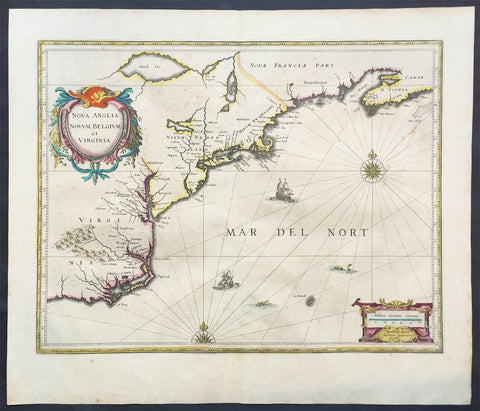
Description: This finely engraved beautifully hand coloured original antique map of Gulf of Mexico, The Caribbean, Virginia to Florida to Texas and Central America, Venezuela was published in the 1639 French edition of Jan Jansson's Atlas Nouvs. This map has been re-joined along the centerold and has some uplift along the centerfold and has been priced accordingly. These maps, published in the later editions of Mercators atlas, are derived from the original maps drawn and engraved by Gerald Mercator in the mid to late 16th century, published by his son Rumold as an atlas, after his death, in 1595. After two editions the plates were purchased by Jodocus Hondius in 1604 andcontinued to be published until the mid 1630's when the plates were re-engraved and updated by Jan Jansson and Henricus Hondius.
General Description: Paper thickness and quality: - Heavy and stable Paper color: - off white Age of map color: - Original Colors used: - Green, red, orange, yellow, blue General color appearance: - Authentic Paper size: - 22 1/2in x 18 3/4in (570mm x 475mm) Plate size: - 20 1/2in x 15 1/4in (525mm x 390mm) Margins: - Min 1in (25mm) Imperfections: Margins: - Light creasing Plate area: - Light uniform age toning, centerfold re-joined with light uplift Verso: - Light age toning
Background: Cartographically this map draws on the extremely rare chart by Hessel Gerritsz, c.1631. The area of coverage is exactly the same with the exception of the addition of the west coast of Central America. The nomenclature of the North American part is virtually identical, the only notable addition being the naming of Virginia. It reflects the firsthand knowledge of Gerritsz during his voyage to South America and the West Indies undertaken in 1628. The distance between Chesapeake Bay and Albemarle Sound is accurately portrayed at 1°; even in Gerritsz's acclaimed NOVA ANGLIA ..., for de Laet, 1630, this distance is over 2°. It seems likely that a Spanish chart was used as the nomenclature along the south-east coast lacks any of the French influences often seen at the time.(Ref: Burden; Tooley, Koeman)