Welcome to Classical Images!
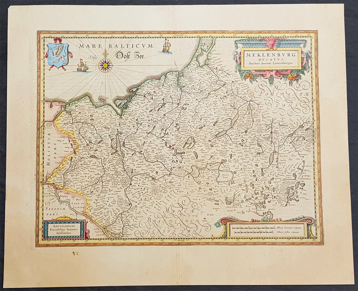
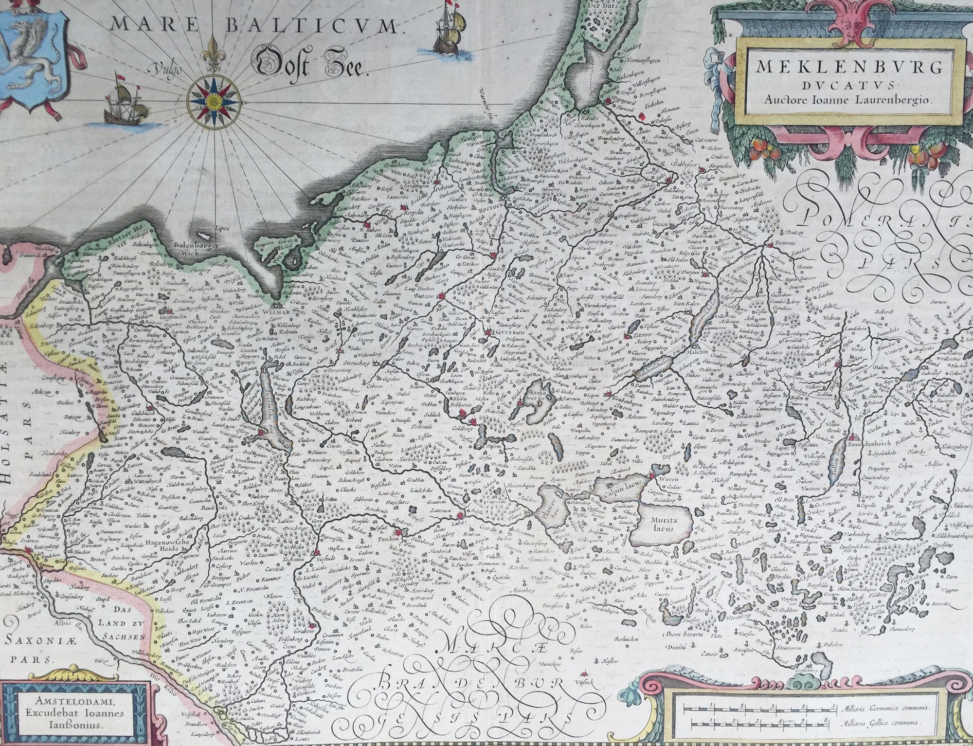
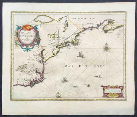
Description:This beautifully hand coloured original copper-plate engraved antique map of the Mecklenburg, north eastern Germany by Jan Jansson was published in the 1646 Latin edition of Mercators Atlas by Jan Jansson and Henricus Hondius. (Ref: Tooley, Koeman)
General Definitions:Paper thickness and quality: - Heavy and stablePaper color : - off whiteAge of map color: - OriginalColors used: - Yellow, green, blue, pinkGeneral color appearance: - AuthenticPaper size: - 22in x 18in (560mm x 460mm)Plate size: - 19in x 14 1/2in (480mm x 370mm)Margins: - Min 2in (50mm)
Imperfections:Margins: - NonePlate area: - NoneVerso: - None
Background: Mecklenburg is a historical region in northern Germany comprising the western and larger part of the federal-state Mecklenburg-Vorpommern. The largest cities of the region are Rostock, Schwerin, Neubrandenburg, Wismar and Güstrow.The name Mecklenburg derives from a castle named Mikilenburg (Old Saxon: big castle, hence its translation into New Latin and Greek: Megalopolis), located between the cities of Schwerin and Wismar. In Slavic language it was known as Veligrad, which also means big castle. It was the ancestral seat of the House of Mecklenburg; for a time the area was divided into Mecklenburg-Schwerin and Mecklenburg-Strelitz among the same dynasty.Linguistically Mecklenburgers retain and use many features of Low German vocabulary or phonology.Mecklenburg is the site of many prehistoric dolmen tombs. Its earliest organised inhabitants may have had Celtic origins. By no later than 100 BC the area had been populated by pre-Christian Germanic peoples.The traditional symbol of Mecklenburg, the grinning steers head (Low German: Ossenkopp, lit.: oxen\'s head, with osse being a synonym for steer and bull in Middle Low German), with an attached hide, and a crown above, may have originated from this period. It represents what early peoples would have worn, i.e. a steers\'s head as a helmet, with the hide hanging down the back to protect the neck from the sun, and overall as a way to instill fear in the enemy.From the 7th through the 12th centuries, the area of Mecklenburg was taken over by Western Slavic peoples, most notably the Obotrites and other tribes that Frankish sources referred to as Wends. The 11th century founder of the Mecklenburgian dynasty of Dukes and later Grand Dukes, which lasted until 1918, was Nyklot of the Obotrites.In the late 12th century, Henry the Lion, Duke of the Saxons, conquered the region, subjugated its local lords, and Christianized its people, in a precursor to the Northern Crusades. From 12th to 14th century, large numbers of Germans and Flemings settled the area (Ostsiedlung), importing German law and improved agricultural techniques. The Wends who survived all warfare and devastation of the centuries before, including invasions of and expeditions into Saxony, Denmark and Liutizic areas as well as internal conflicts, were assimilated in the centuries thereafter. However, elements of certain names and words used in Mecklenburg speak to the lingering Slavic influence. An example would be the city of Schwerin, which was originally called Zuarin in Slavic. Another example is the town of Bresegard, the \'gard\' portion of the town name deriving from the Slavic word \'grad\', meaning city or town.Since the 12th century, the territory remained stable and relatively independent of its neighbours; one of the few German territories for which this is true. During the reformation the Duke in Schwerin would convert to Protestantism and so would follow the Duchy of Mecklenburg.Like many German territories, Mecklenburg was sometimes partitioned and re-partitioned among different members of the ruling dynasty. In 1621 it was divided into the two duchies of Mecklenburg-Schwerin and Mecklenburg-Güstrow. With the extinction of the Güstrow line in 1701, the Güstrow lands were redivided, part going to the Duke of Mecklenburg-Schwerin, and part going to the new line of Mecklenburg-Strelitz.In 1815, the two Mecklenburgian duchies were raised to Grand Duchies, the Grand Duchy of Mecklenburg-Schwerin and the Grand Duchy of Mecklenburg-Strelitz, and subsequently existed separately as such in Germany under enlightened but absolute rule (constitutions being granted on the eve of World War I) until the revolution of 1918. Life in Mecklenburg could be quite harsh. Practices such as having to ask for permission from the Grand Duke to get married, or having to apply for permission to emigrate, would linger late into the history of Mecklenburg (i.e. 1918), long after such practices had been abandoned in other German areas. Even as late as the later half of the 19th century the Grand Duke personally owned half of the countryside. The last Duke abdicated in 1918, as monarchies fell throughout Europe. The Duke\'s ruling house reigned in Mecklenburg uninterrupted (except for two years) from its incorporation into the Holy Roman Empire until 1918. From 1918 to 1933, the duchies were free states in the Weimar Republic.Traditionally Mecklenburg has always been one of the poorer German areas, and later the poorer of the provinces, or Länder, within a unified Germany. The reasons for this may be varied, but one factor stands out: agriculturally the land is poor and can not produce at the same level as other parts of Germany. The two Mecklenburgs made attempts at being independent states after 1918, but eventually this failed as their dependence on the rest of the German lands became apparent.