
Jean Baptiste Bourguignon D'Anville (1697-1782)
Profile :
Following the death of Guillaume Delisle, D'Anville continued the line of progressive French cartographers which had begun with Nicolas Sanson in the previous century.
He is said to have designed his first map at the age of fifteen and in a long and active life he produced a great number of elegantly engraved maps, noted for their scholarship and accuracy. If anything, he was even more critical of the work of his predecessors than Delisle and his exacting standards soon brought him international recognition as the finest cartographer of his time. In fact, during his whole life he never travelled outside Paris but he built up a vast collection of cartographic material which eventually was passed to the Bibliotheque Nationale.
He was specially interested in the geography of the East and he designed maps for a Description geographique de Ia Chine by Pere J. B. du Halde (1735), a notable work of the day based on surveys and reports of Jesuit missionaries. These maps were also issued in Nouvel Atlas de Ia Chine in 1737 and were the first to give a reasonably accurate picture of that remote land. From about 1740 onwards he published collections of maps under the title Atlas Generate which went through numerous expanding editions in various languages; English editions were printed by Robert Sayer, Laurie and Whittle, and others into the next century
Jean Baptiste Bourguignon d' Anville (2)
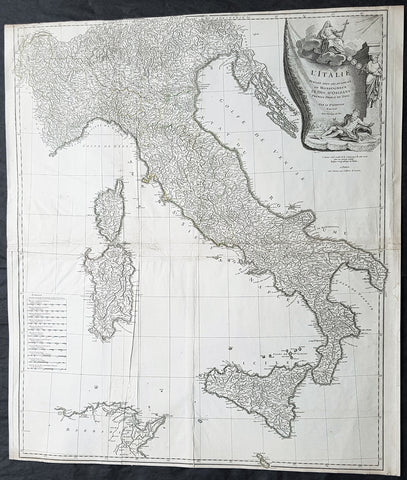
1743 D Anville & CA Coypel Large Antique Map of Italy, Sicily, Sardinia, Corsica
- Title : L Italie Publiee Sous Les Auspices De Monseigneur Le Duc D Orleans, Premier Prince Du Sang....Par L Sr D Anville...MDCCXLIII
- Date : 1743
- Condition: (A) Very Good Condition
- Ref: 92312
- Size: 32in x 28in (820mm x 710mm)
Description:
This large scarce original copper-plate engraved antique map of contemporary Italy, Sicily, Sardinia, Corsica & Malta by Charles-Antoine Coypel was engraved by Pierre-Alexandre Aveline (1702–1760) (both names engraved under cartouche) in 1743 - dated in cartouche - and was published by Jean-Baptiste Bourguinon D Anvilles in his large elephant folio atlas Atlas Generale.
A scarce and hard to find map with two famous names Charles-Antoine Coypel & Pierre-Alexandre Aveline engraved below the cartouche, I am assuming as both drawer & engraver.
General Definitions:
Paper thickness and quality: - Heavy and stable
Paper color : - off white
Age of map color: -
Colors used: -
General color appearance: -
Paper size: - 32in x 28in (820mm x 710mm)
Plate size: - 31 1/2in x 27in (810mm x 690mm)
Margins: - Min 1/8in (2mm)
Imperfections:
Margins: - Top margin cropped to border
Plate area: - Light creasing
Verso: - Creasing
Background:
Since classical times the countries bordering the enclosed waters of the Mediterranean had been well versed in the use of maps and sea charts and in Italy, more than anywhere else, the traditional knowledge was kept alive during the many hundreds of years following the collapse of the Roman Empire. By the thirteenth and fourteenth centuries the seamen of Venice, Genoa and Amalfi traded to far countries, from the Black Sea ports and the coasts of Palestine and Egypt in the East to Flanders and the southern coasts of England and Ireland in the West, their voyages guided by portulan charts and the use of the newly invented compass. For a time Italian supremacy in cartography passed to Aragon and the Catalan map makers based on Majorca, but by the year 1400 the power and wealth of the city states of Venice, Genoa, Florence and Milan surpassed any in Europe. Florence, especially, under the rule of the Medici family, became not only a great trading and financial centre but also the focal point of the rediscovery of the arts and learning of the ancient world. In this milieu a number of manuscript world maps were produced, of which one by Fra Mauro (c. 1459) is the most notable, but the event of the greatest importance in the history of cartography occurred in the year 1400 when a Florentine, Palla Strozzi, brought from Constantinople a Greek manuscript copy of Claudius Ptolemy\\\'s Geographia, which, 1,250 years after its compilation, came as a revelation to scholars in Western Europe. In the following fifty years or so manuscript copies, translated into Latin and other languages, became available in limited numbers but the invention of movable-type printing transformed the scene: the first copy without maps being printed in 1475 followed by many with copper-engraved maps, at Bologna in 1477, Rome 1478, 1490, 1507 and 1508, and Florence 1482.
About the year 1485 the first book of sea charts, compiled by Bartolommeo dalli Sonetti, was printed in Venice and in the first part of the sixteenth century a number of world maps were published, among them one compiled in 1506 by Giovanni Contarini, engraved by Francesco Rosselli, which was the first printed map to show the discoveries in the New World. In the following years there were many attractive and unusual maps of Islands (Isolano) by Bordone, Camocio and Porcacchi, but more important was the work of Giacomo (Jacopo) Gastaldi, a native of Piedmont who started life as an engineer in the service of the Venetian Republic before turning to cartography as a profession. His maps, produced in great variety and quantity, were beautifully drawn copperplate engravings and his style and techniques were widely copied by his contemporaries. From about 1550 to 1580 many of Gastaldi\\\'s maps appeared in the collections of maps known as Lafreri \\\'atlases\\\', a term applied to groups of maps by different cartographers brought together in one binding. As the contents of such collections varied considerably they were no doubt assembled at the special request of wealthy patrons and are now very rare indeed.
About this time, for a variety of historical and commercial reasons, Italy\\\'s position as the leading trading and financial nation rapidly declined and with it her superiority in cartography was lost to the vigorous new states in the Low Countries. That is not to say, of course, that Italian skills as map makers were lost entirely for it was not until 1620 that the first printed maps of Italy by an Italian, Giovanni Magini, appeared, and much later in the century there were fine maps by Giacomo de Rossi and Vincenzo Coronelli, the latter leading a revival of interest in cartography at the end of the century. Coronelli was also famous for the construction of magnificent large-size globes and for the foundation in Venice in 1680 of the first geographical society.
In the eighteenth century the best-known names are Antonio Zatta, Rizzi-Zannoni and Giovanni Cassini.
We ought to mention the work of Baptista Boazio who drew a series of maps in A Summarie and True Discourse of Sir Francis Drake\\\'s West Indian Voyage, published in 1588-89, and who is especially noted for a very fine map of Ireland printed in 1599 which was incorporated in the later editions of the Ortelius atlases. It is perhaps appropriate also to refer to two English map makers who spent many years in exile in Italy: the first, George Lily, famous for the splendid map of the British Isles issued in Rome in 1546, and the second, Robert Dudley, who exactly one hundred years later was responsible for the finest sea atlas of the day, Dell\\\' Arcano del Mare, published in Florence. Both of these are described in greater detail elsewhere in this handbook. (Ref: Tooley, Koeman)
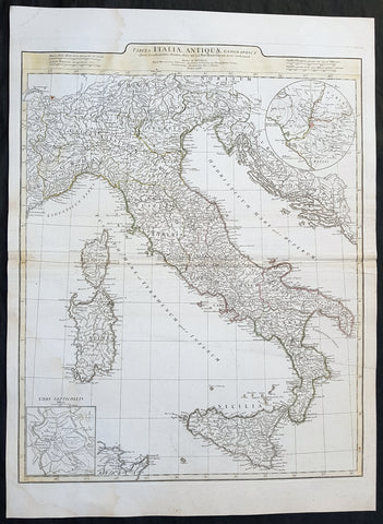
1764 J B D Anville Large Original Antique Map of Italy inset plan of Rome
- Title : Tabula Italiae Antiqua Geographica...MDCCLXIV
- Date : 1764
- Size: 29in x 21in (740mm x 535mm)
- Ref #: 92297
- Condition: (A+) Fine Condition
Description:
This large finely engraved and highly detailed original antique map of Italy by Jean Baptiste Bourguignon D\'Anville was engraved in 1764 - dated in the tile cartouche - and was published in Jean-Baptiste Bourguinon D\'Anville\'s large elephant folio atlas Atlas Generale.
General Definitions:
Paper thickness and quality: - Heavy and stable
Paper color : - off white
Age of map color: - Original
Colors used: - Yellow, green, pink, blue
General color appearance: - Authentic
Paper size: - 29in x 21in (740mm x 535mm)
Plate size: - 25in x 20in (635mm x 510mm)
Margins: - Min 1/2in (12mm)
Imperfections:
Margins: - Age toning along centerfold
Plate area: - Age toning along centerfold
Verso: - Age toning along centerfold
Background:
Since classical times, ancient Phoenicians, Carthaginians and Greeks established settlements in the south of Italy, with Etruscans and Celts inhabiting the centre and the north of Italy respectively and various ancient Italian tribes and Italic peoples dispersed throughout the Italian Peninsula and insular Italy. The Italic tribe known as the Latins formed the Roman Kingdom, which eventually became a republic that conquered and assimilated other nearby civilisations. Ultimately the Roman Empire emerged as the dominant power in the Mediterranean basin, conquering much of the ancient world and becoming the leading cultural, political and religious centre of Western civilisation. The legacy of the Roman Empire is widespread and can be observed in the global distribution of civilian law, republican governments, Christianity and the Latin script.
During the Early Middle Ages Italy suffered sociopolitical collapse amid calamitous barbarian invasions, but by the 11th century, numerous rival city-states and maritime republics, mainly in the northern and central regions of Italy, rose to great prosperity through shipping, commerce and banking, laying down the groundwork for modern capitalism.These mostly independent statelets, acting as Europe\'s main spice trade hubs with Asia and the Near East, often enjoyed a greater degree of democracy and wealth in comparison to the larger feudal monarchies that were consolidating throughout Europe at the time, though much of central Italy remained under the control of the theocratic Papal States, while Southern Italy remained largely feudal until the 19th century, partially as a result of a succession of Byzantine, Arab, Norman and Spanish conquests of the region.
The Renaissance began in Italy and spread to the rest of Europe, bringing a renewed interest in humanism, science, exploration and art. Italian culture flourished at this time, producing famous scholars, artists and polymaths such as Leonardo da Vinci, Galileo, Michelangelo and Machiavelli. Italian explorers such as Marco Polo, Christopher Columbus, Amerigo Vespucci and Giovanni da Verrazzano discovered new routes to the Far East and the New World, helping to usher in the European Age of Discovery. Nevertheless, Italy\'s commercial and political power significantly waned with the opening of the Atlantic trade route and the route to the Indian Ocean via the Cape of Good Hope, both of which bypassed the Mediterranean. Furthermore, the Italian city-states constantly engaged one another in bloody warfare, culminating in the Italian Wars of the 15th and 16th centuries that left them exhausted, with no one emerging as a dominant power. The weakened Italian sovereigns soon fell victim to conquest by European powers such as France, Spain and Austria.