Welcome to Classical Images!
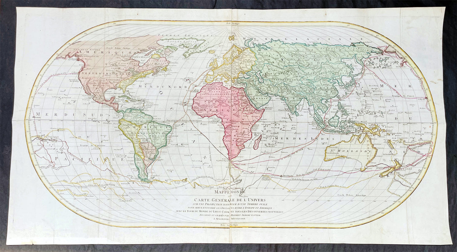
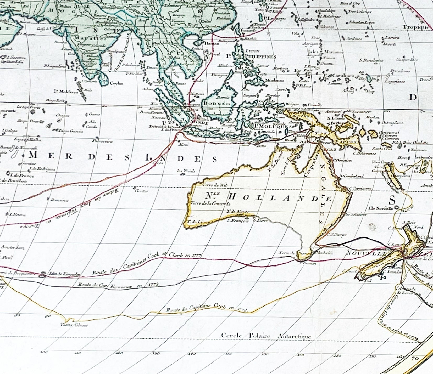
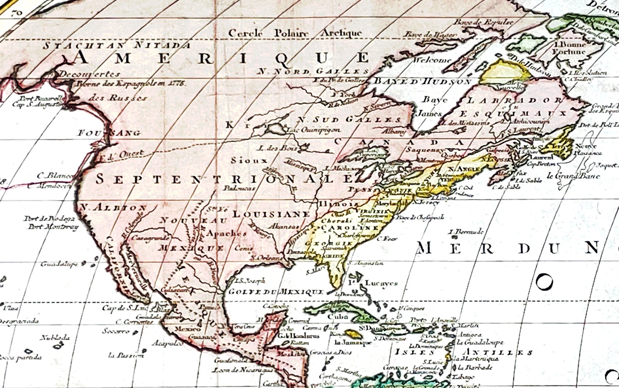
Description:This very large, impressive original copper-plate engraved antique World Map, on an Ortelius Oval Projection, was engraved and published by Matthäus Albrecht Lotter in 1782, dated in title.The map was first issued in 1778 and re-issued in 1782 & 1787 and included all three of Cooks voyages of discovery. This map was one of the first world maps published to cash in on the publicity over Captain James Cooks Circumnavigation of the world and the first European survey of New Zealand and the East Coast of Australia. Beautifully executed and dominated by New Holland, Australia, for the first time almost complete on a world map.
General Definitions:Paper thickness and quality: - Heavy and stablePaper color : - off whiteAge of map color: - OriginalColors used: - Yellow, green, pinkGeneral color appearance: - AuthenticPaper size: - 38 1/2in x 21in (985mm x 535mm)Plate size: - 37 1/2in x 19 1/4in (955mm x 495mm)Margins: - Min 1in (25mm)
Imperfections:Margins: - Folds as issue, light soilingPlate area: - Folds as issue, light soilingVerso: - Folds as issue, light soiling
Background: This large world map was one of the first to show the discoveries of the east coast of Australia and New Zealand by James Cook on his first voyage of Discovery. The shadow line from Tasmania west to Western Australia was not filled in until the later discoveries of Bass Strait by Bass and Matthew Flinders in 1797 and the southern coast by Baudin and Flinders in 1803. Also included along the New Holland coastline is the earlier Dutch discoveries of Hartog 1616, the van Leeuwin 1619, Nuyts 1627, de Wit 1628 and Tasman 1642-44. The Trial Islands near present-day Dampier, named after the English ship the Trial, which were incorrectly charted by Gerritsz after the false reports provided by Captain Brookes, are also noted.Cooks First Voyage (1768-1771)The first voyage under Captain James Cook\\\\\\\'s command was primarily of a scientific nature. The expedition on the Endeavour initially sailed to Tahiti to observe the transit of the planet Venus in order to calculate the earth\\\\\\\'s distance from the sun. Cook landed on the South Pacific island in April of 1769 and in June of that year the astronomical observations were successfully completed. In addition to these labors, very good relations with the Tahitians were maintained and the naturalists Joseph Banks and Daniel C. Solander conducted extensive ethnological and botanical research.Another purpose of the voyage was to explore the South Seas to determine if an inhabitable continent existed in the mid-latitudes of the Southern Hemisphere. Upon leaving Tahiti, Cook named and charted the Society Islands and then continued southwest to New Zealand. His circumnavigation and exploration of that country also resulted in a detailed survey. Cook proceeded to Australia, where he charted the eastern coast for 2,000 miles, naming the area New South Wales. As a result of these surveys, both Australia and New Zealand were annexed by Great Britain. In addition to these explorations, the Endeavour returned to England without a single death from scurvy among its men, an historic feat at the time. The combination of these accomplishments brought Cook prominence, promotion, and the opportunity to lead further expeditions.Cooks Second Voyage (1772-1775)Based on the success of his first voyage, Cook was appointed by the Admiralty to lead a second expedition. Two ships were employed with Cook commanding the Resolution and Captain Tobias Furneaux in charge of the Adventure. The purpose was to circumnavigate the globe as far south as possible to confirm the location of a southern continent. Cook proved that there was no Terra Australis, which supposedly was located between New Zealand and South America. Cook was convinced, however, that there was land beyond the southern ice fields. In his pursuit of this idea, this expedition was the first European voyage to cross the Antarctic Circle. In addition, in two great sweeps through the Southern latitudes, Cook made an incredible number of landfalls including New Zealand, Easter Island, the Marquesas, Tahiti and the Society Islands, the Tonga Islands, the New Hebrides, New Caledonia, and a number of smaller islands.In addition to these navigational accomplishments and the accompanying expansion of geographical knowledge, the expedition also recorded a vast amount of information regarding the Pacific islands and peoples, proved the value of the chronometer as an instrument for calculating longitude, and improved techniques for preventing scurvy.Cooks Third Voyage (1776-1779)In the course of his first two voyages, Cook circumnavigated the globe twice, sailed extensively into the Antarctic, and charted coastlines from Newfoundland to New Zealand. Following these achievements, Cooks third voyage was organized to seek an efficient route from England to southern and eastern Asia that would not entail rounding the Cape of Good Hope. The search for such a Northwest (or Northeast) Passage had been on the agenda of northern European mariners and merchants since the beginning of European expansion in the late fifteenth century. England\\\\\\\'s growing economic and colonial interests in India in the later eighteenth century provided the stimulus for the latest exploration for this route.Cook, again in command of the Resolution, was to approach the Northwest Passage from the Pacific accompanied by a second ship, the Discovery, captained by Charles Clerke. The ships left England separately, regrouped at Cape Town, and continued on to Tasmania, New Zealand, and Tahiti. The expedition then sailed north and made landfall at Christmas Island and the Hawaiian Islands. Cook continued northward and charted the west coast of North America from Northern California as far as the Bering Strait. He returned to Hawaii for the winter and was killed in a skirmish with natives on February 14, 1779. Upon Cooks death, Clerke took command of the expedition but died six months later. The ships returned to England in 1780 under John Gore, who had commanded the Discovery after Cooks death. From start to finish, the voyage had lasted more than four years. (Ref Tooley; M&B; Clancy)The Ortelius Oval Projection is a map projection used for world maps largely in the late 16th and early 17th century. It is neither conformal nor equal-area but instead offers a compromise presentation. It is similar in structure to a pseudocylindrical projection but does not qualify as one because the meridians are not equally spaced along the parallels. The projection\'s first known use was by Battista Agnese (flourished 1535–1564) around 1540, although whether the construction method was truly identical to Ortelius\'s or not is unclear because of crude drafting and printing. The front hemisphere is identical to Petrus Apianus\'s 1524 globular projection.The projection reached a wide audience via the popular map Typus Orbis Terrarum by Abraham Ortelius beginning in 1570. The projection (and indeed Ortelius maps) were widely copied by other mapmakers such as Giovanni Pietro Maffei, Fernando de Solis, and Matteo Ricci.