Welcome to Classical Images!
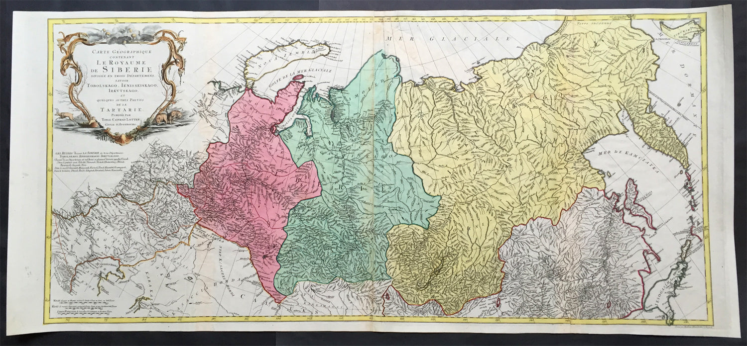
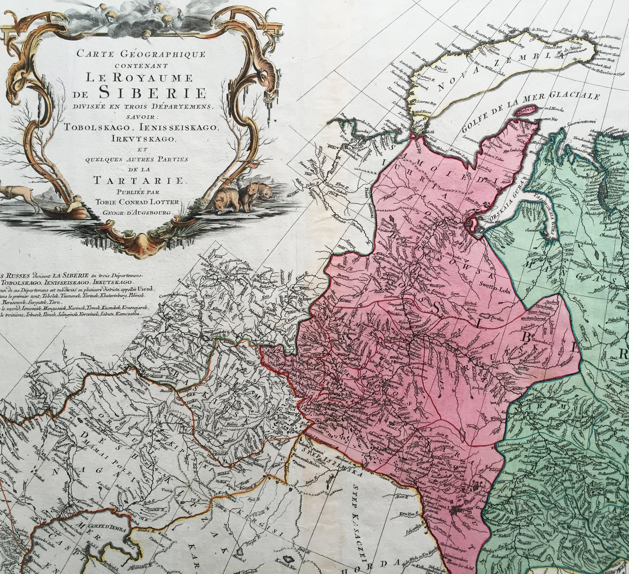
Description: This scarce, very large beautifully hand coloured original antique map of Russia and Siberia with parts of China was published by Tobias Conrad Lotter in 1770.
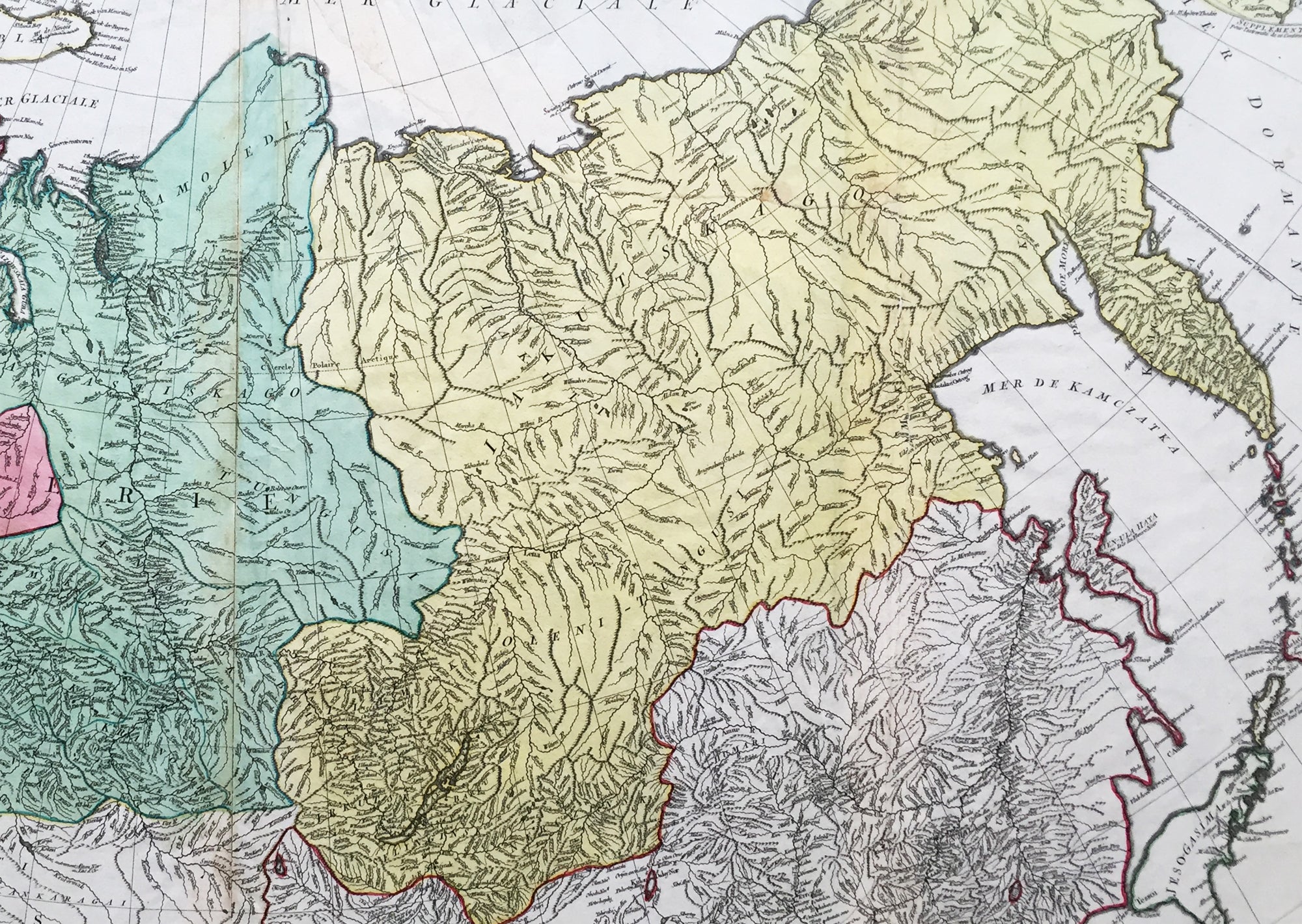
Background: Rare, highly detailed map of Russia & Siberia that is subdivided into provinces, namely Tobolsk, Jenissejesk, Irkutsk, and outer parts of the Tartary. In upper right corner inset-map of the Chukchi (Chukotsk) Peninsula. On the left side sheet is a large title cartouche set in a steppe landscape with reindeer sledge, whale and polar bears. Scale ca. 1 : 13,000,000 and engraved by Matthäus Albrecht Lotter for Tobias Conrad Lotter. In about 1770 a map of Russia & Siberia by Ivan Fomic Truscot (1721-1786, comp. BMC XXII, 353) was published, that comprised the West Siberian states Tobolsk and Yeniseiesk only, but may have been quite available to Lotter, just as also the German edition of the third Russian general map by Truscot and Jacob F. Schmidt of 1776 was published by Lotter in 1784. The comparison of the Asian north-eastern coast from Japan up to Cape Szalaginskoi (Cape Shelagskiy) together with the offshore islands there results in an astonishing similarity with representation and designation on Rigobert Bonne’s maps of Russia and the Chinese Tartary published by Lattré in Paris in 1771. Especially striking the form of Sakhalin that hitherto – but also still on the Truscot map of 1776 – appears far more stocky, here though shows a slimmer shape considerably closer to reality. Cape Patience known at least since the 1743 Utrecht edition of the map of Russia by Johann Matthias Haas (Augsburg 1684 – Wittenberg/Augsburg 1742) – Kaert van Het geheele Russische Keizerryk – already published by Homann Heirs in Nuremberg in 1730 + 39 here supposedly for the first time shown in unity with Sakhalin and, as the long-stretched southern half beginning west of the cape already recognizable there is missing here, together forming its southern tip. Of great similarity, too, the still completely bulky representation of Jeso (= Hokkaido), filling up large parts of the Sea of Japan as known sufficiently from numerous, though by far not all maps of the 18th century. The Kurile Islands adjacent in northeastern direction – with rich detail designation, but without the denomination as chain of islands appearing at least in the 1784 edition of Truscot’s general map – with the obscure islands Terre des Etat (Iturup) and Terre de la Compagnie. Both, as also the often furthermore adjacent da Gama Land, had been supposedly finally left by Truscot to the memory of the great time of sometimes only vague discoveries. Interestingly both islands are designated with hints to Russian maps in question marks. This probably to be seen as a sign for an independent work of Lotter who obviously drew his knowledge from different sources and not just copied a map he had got into his hands for a German edition. Further clue to the dating is, too, the taking over of the Chukchi (Chukotsk) Peninsula in the farest northeast of Asia in the shape practically unchanged since Ivan Kirilov’s (1695 – Samara 1737) general map of 1734 – the first Russian one at all. For at the latest since publishing the Truscot map of 1776 in 1784 Lotter would have known the new shape valid till today. Likewise Novaya Zemlya here still figuring as undivided island, thus without the Matochkin Strait supposedly recorded by Truscot for the first time. With respect to the independence of his work a recourse to older forms of representation appears not very likely in both cases. Designed in cone projection, the null meridian runs about 020degrees western longitude of Greenwich through the centre of Iceland. In the west reaching till Novaya Zemlya – Ural Mountains – Kazan – Sea of Azov, the map comprises in the far east still northern Japan , the Kurile Islands and Kamchatka including the offshore Bering Island . Southerly still with at the Caspian Sea , Lake Aral , the headwaters of the Yenisey , the Dalai nuur (Hulun Lake) in northern Mongolia near to the wall of Genghis Chan , the region of today’s Vladivostok and the Tsugari Street . In the Arctic Ocean up to 78 degrees northern latitude. (Ref: Tooley, M&B)
General Description: Paper thickness and quality: - Heavy and stable Paper color: - off white Age of map color: - Original Colors used: - Pink, green, yellow General color appearance: - Authentic Paper size: - 44in x 20 1/2in (1.15m x 520mm) Plate size: - 42in x 19 1/2in (1.0mm x 500mm) Margins: - Min 1/2in (12mm) Imperfections: Margins: - None Plate area: - Repair to top adjacent to centerfold, no loss Verso: - Repair as mentioned