Welcome to Classical Images!
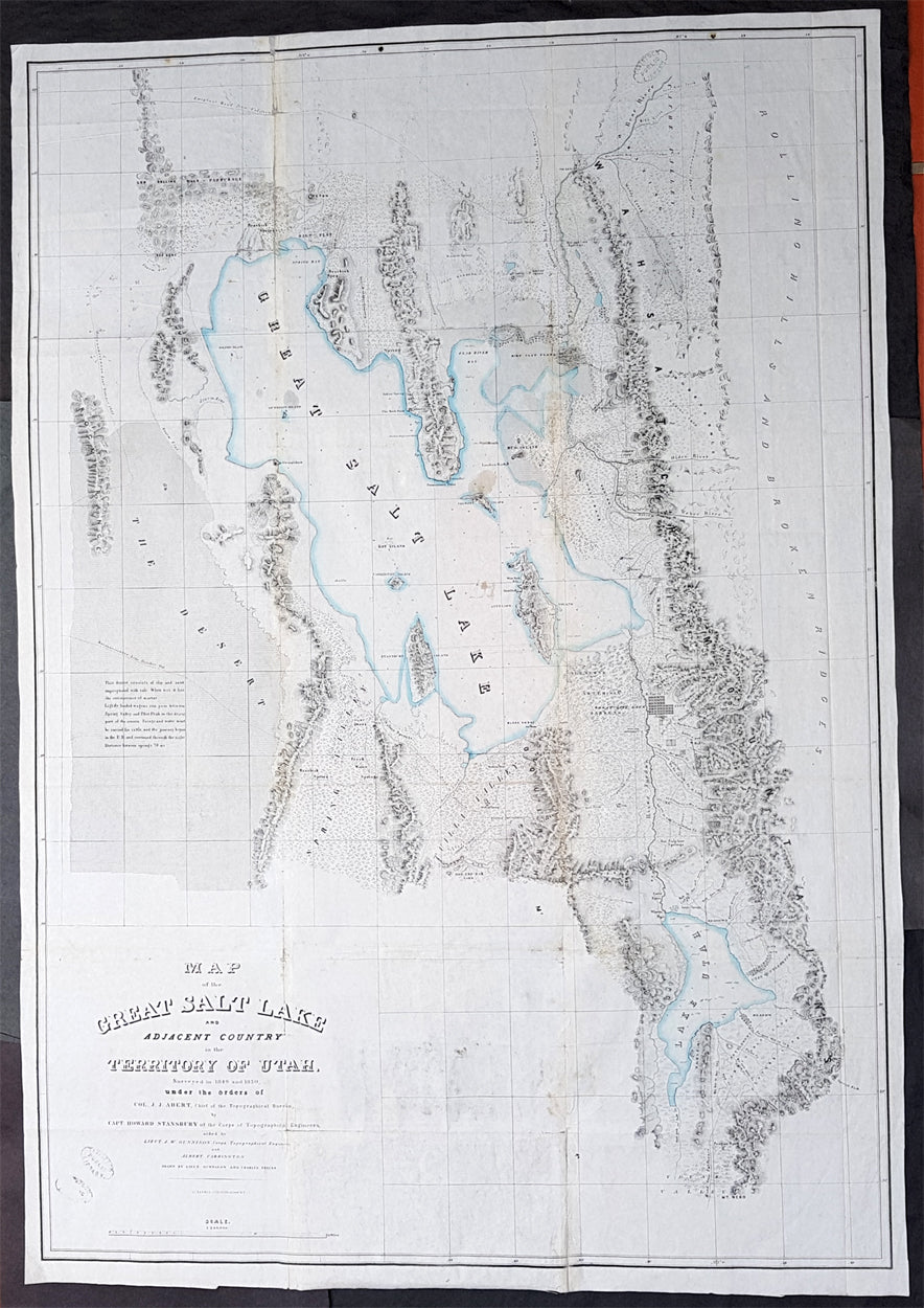
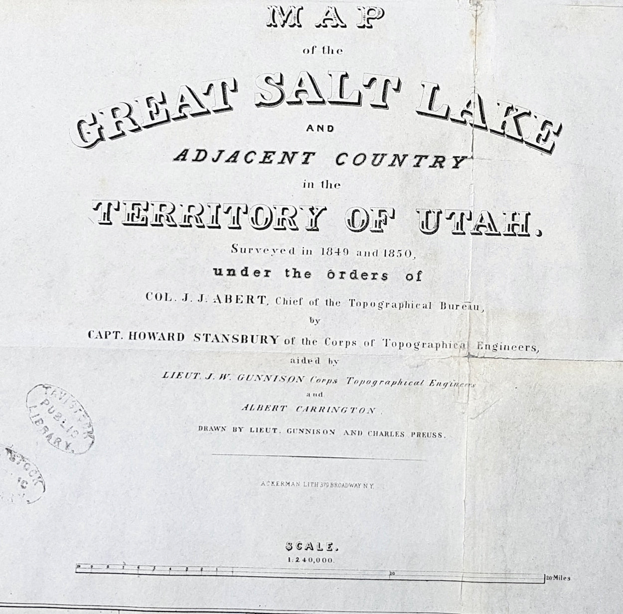
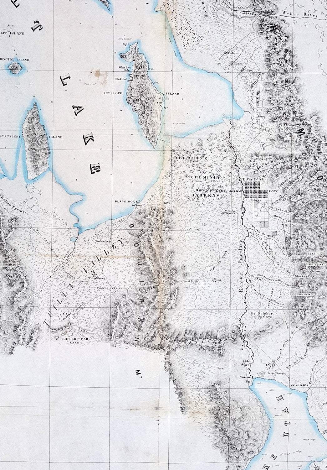
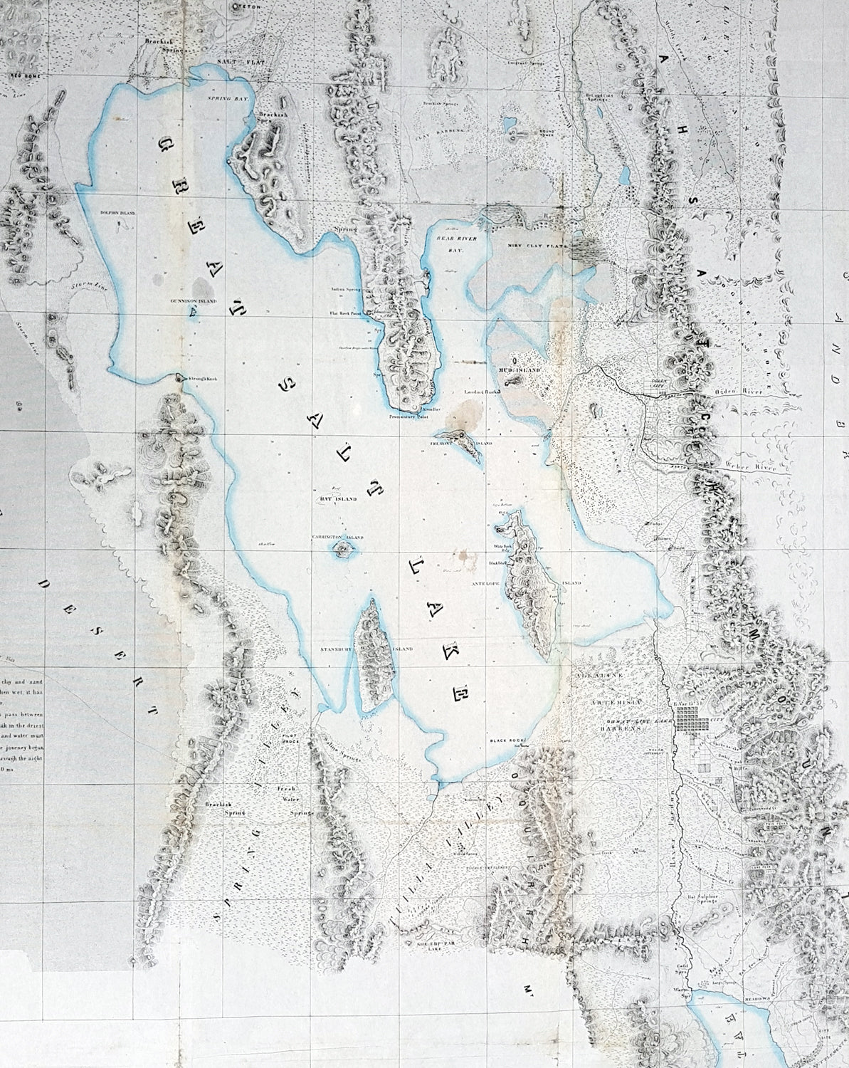
Description:This large original antique lithograph map of the Great Salt Lake of Utah by Howard Stansbury, in 1849-50, is considered to be the first concise and complete survey of the Great Basin and a cartographical milestone of American cartography. This large map along with another, of the route taken by the expedition from Fort Leavenworth to the Great Salt Lake, was drawn by Henry Gunnison & Charles and published by the publishing house Ackermann, New York City in 1852.Stansbury was commissioned by Congress to survey the Great Salt Lake in the Utah Valley in 1849. Heading west using old known tracks and local knowledge, Stansbury along with his expedition, completed the task in 2 years presenting their report, along with two very large maps, to Congress in 1852.The map stretches from the Bear River in the north to Mount Nebo in the south, and from the Rocky Mountains in the west to the Great Plains in the east, The map resulted from 2 years of hard work, luck and scientific tenacity, containing significant and first hand detail, identifying springs, rivers, passes, American Indian settlements, canals, and much more. His work identified detail of the local inhabitants and is one of the earliest maps to include a plan of Salt Lake City.Stansbury attempts to provide useful travelling detail that is included in the map from both directions, east & west and was instrumental in helping the early settlers coming from both directions.......This desert consists of clay and sand impregnated with salt. When wet, it has the consistency of mortar. Lightly loaded wagons can pass between Spring Valley and Pilot Peak in the driest part of the season. Forage and water must be carried for cattle, and the journey begun in the P. M. and continued through the night. Distance between springs 70 ms.....Along with depth soundings of the lake, many of the islands are named after people of that original expedition, Stansbury, Carrington, Gunnison & Fremont all hand island named after them.In his study of American exploration, Carl Wheat (1892-1966) devotes considerable attention to this map,........Obviously a major production...an illuminating map of Great Salt Lake, Utah Lake, their respective valleys, and a portion of ‘Youab\' (Juab) Valley to the south.... This map permanently established the cartography and many place names of north-western Utah.... One of its most attractive features is that it gives the Indian as well as the Mormon names of the various creeks draining from the mountains. For Great Salt Lake itself the map was definitive, of course, permanent names being given to all the islands and shoreline features.... Scientific cartography for the Territory of Utah may be said to date from the appearance of this map......
General Definitions:Paper thickness and quality: - Heavy and stablePaper color : - off whiteAge of map color: - OriginalColors used: - BlueGeneral color appearance: - AuthenticPaper size: - 45 1/2in x 32in (1.155mm x 815mm)Plate size: - 45 1/2in x 32in (1.155mm x 815mm)Margins: - Min 1/2in (12mm)
Imperfections:Margins: - NonePlate area: - Folds as issued, small repair along a couple of folds, light age toningVerso: - Re-enforced along folds with transparent archival tape
Background: In 1849 Stansbury was ordered to travel from Fort Leavenworth, Kansas to survey the Great Salt Lake in Utah, evaluate emigration trails along the way, especially the Oregon and Mormon trails and to scout for possible locations for a transcontinental railroad. The expedition consisted of 18 men including his second in command Lieutenant John Williams Gunnison. Over the following two years, the expedition explored the Great Salt Lake, Utah Lake and the Cache Valley of northern Utah all the way to Fort Hall in southern Idaho. Upon first arriving in Utah the Mormon leaders were worried that the expedition was part of an effort by the U.S government to oust the Mormon settlers. Stansbury held a meeting with Brigham Young where he assured the leader that the expedition was purely a scientific one. Young responded by assigning his personal secretary Albert Carrington to assist the expedition. Upon completing the mission in Utah, the expedition started back east to Leavenworth. Rather than follow the standard Oregon Trail route from Fort Bridger over South Pass through the Sweetwater River valley, Stansbury wanted to scout a more direct route east. Following the advice of Jim Bridger and local trappers and traders the expedition followed the Blacks Fork River east, crossed the Green River near the present day town of Green River, Wyoming and proceeded east along the Bitter Creek valley, crossing the Red Desert, and skirting the northern side of Elk Mountain across the Laramie Plains. They passed over the Laramie Mountains and made their way to Fort Laramie where they struck the Oregon Trail heading east. Stansbury's seminal 1852 map of the Great Salt Lake region in Utah is considered to be the first accurate survey of the Great Basin as well as a cornerstone achievement in the mapping of the American West. The first westerner to visit the Great Basin was most likely Silvestre Vélez de Escalante in the 1776, however, Escalante, who visited Utah Lake to the south, never truly laid eyes on Great Salt Lake. That honor would fall to unnamed trappers and mountain men travelling the region
Stansbury, Howard 1806 - 1863Stansbury was an important surveyor, cartographer, and explorer who did his most important work in Utah during the middle part of the 19th century. Born in New York City, Stansbury trained to be a Civil Engineer. Shorty after getting married to Helen Moody of Detroit in 1827, Stansbury took a position with the United States Topographical Bureau. Under that organization he surveyed the James River in 1836, and the Illinois and Kaskaskia Rivers in 1837. In 1838, he oversaw the construction of a road from Milwaukee to the Mississippi River. Later in 1838, when the U.S Corps of Topographical Engineers was created, he joined as a first Lieutenant. With the Topographical Engineers he surveyed the Great Lakes, the harbor of Portsmouth, New Hampshire, and constructed Florida\\\'s Carysfort Reef Lighthouse. During the Mexican-American War he constructed fortification in the Dry Tortugas at the westernmost point on the Florida Keys. Upon achieving the rank of Captain, Stansbury received a commissioned to head a survey of the Great Basin that would ultimately become the crowning achievement of his career. His assignment was to survey the emigrant trails to California, including the Oregon Trail, as well as the Great Salt Lake, and report on the status of the growing Mormon Community in Salt Lake City. Working with J. W. Gunnison and Alfred Carrington, a Mormon scout, Stansbury produced a masterful survey of the region that had a lasting effect not only on the development of the Great Basin, but on the development of the west in general. Upon completion of his survey, Stansbury set out on the road to Washington, completing another important survey in the process. On the way, he fell off his horse, taking an injury from which he never fully recovered. Following the presentation of his report to Congress, Stansbury was charged with additional survey work around the Great Lakes. Upon the outbreak of the American Civil War, he was assigned to recruitment duties in Ohio and later Wisconsin. Shortly after starting work at this post he suffered an abrupt heart attack and passed away. He is buried in St. Paul, Minnesota.