Welcome to Classical Images!
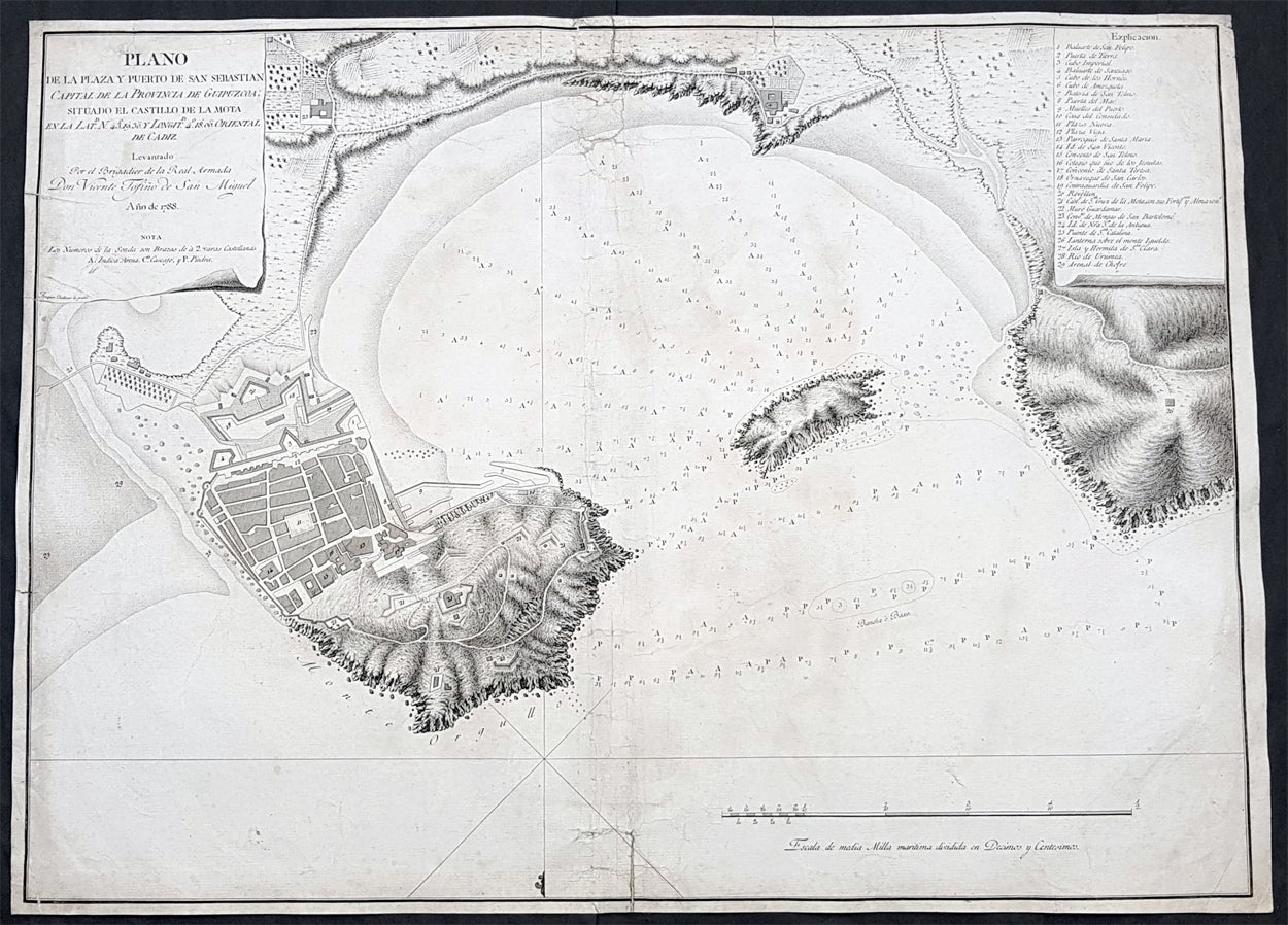
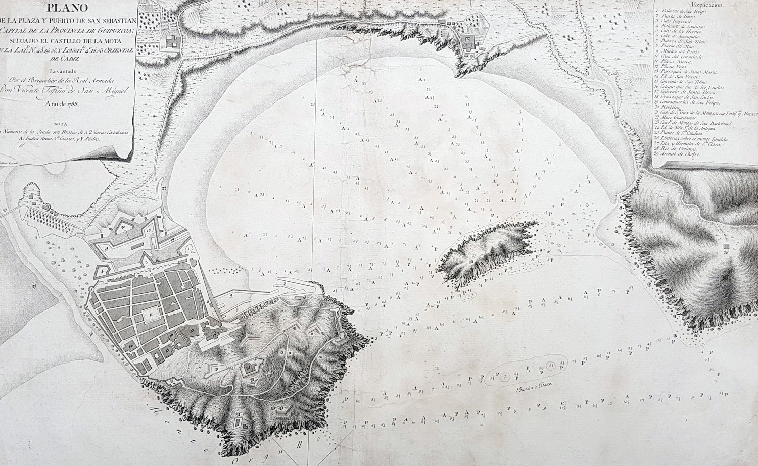
Description:This large original copper plate engraved scarce antique map of the city of San Sebastian and the Bay of La Concha on the northern Basque coast of Spain by the Spanish navigator and cosmographer Vincente Tofiño de San Miguel was engraved in 1788 - dated - and was published in Tofinos 1789 edition of Derrotero de las costas de España en el Océano Atlántico y de las islas Azores o Terceras, para inteligencia y uso de las cartas esféricas (Pilots Log-book of the Coasts of Spain in the Atlantic Ocean and of the Azores, for the use of naval intelligence and nautical charts).
General Definitions:Paper thickness and quality: - Heavy and stablePaper color : - off whiteAge of map color: -Colors used: -General color appearance: -Paper size: - 23 1/2in x 17in (595mm x 435mm)Plate size: - 23 1/2in x 17in (595mm x 435mm)Margins: - Min 1/4in (5mm)
Imperfections:Margins: - 5 small repairs to margins going into imagePlate area: - Soiling, small separation of bottom centerfoldVerso: - Soiling
Background: San Sebastián is a coastal city and municipality located in the Basque Autonomous Community, SpainAfter a long period of silence in evidence, in 1014 the monastery of St. Sebastián with its apple orchards (for cider), located in the term of Hernani, is donated to the Abbey of Leire by Sancho III of Pamplona. By 1181, the city is chartered (given fuero) by king Sancho VI of Pamplona on the site of Izurum, having jurisdiction over all the territory between the rivers Oria and Bidasoa.In 1200, the city was conquered by Castile, whose king Alfonso VIII, confirmed its charter (fuero), but the Kingdom of Navarre was deprived of its main direct access out to the sea. Perhaps as soon as 1204 (or earlier), the city nucleus at the foot of Urgull started to be populated with Gascon-speaking colonizers from Bayonne and beyond, who left an important imprint in the citys identity in the centuries to come.In 1265, the use of the city as a seaport is granted to Navarre as part of a wedding pact. The large quantity of Gascons inhabiting the town favoured the development of trade with other European ports and Gascony. The city steered clear of the destructive War of the Bands in Gipuzkoa, the only town in doing so in that territory. In fact, the town only joined Gipuzkoa in 1459 after the war came to an end. Up to the 16th century, Donostia remained mostly out of wars, but by the beginning of the 15th century, a line of walls of simple construction is attested encircling the town. The last chapter of the town in the Middle Ages was brought about by a fire that devastated Donostia in 1489. After burning to the ground, the town began a new renaissance by building up mainly with stone instead of bare timber.The advent of the Modern Age brought a period of instability and war for the city. New state boundaries were drawn that left Donostia located close to Spains border with France; thicker and more sophisticated walls were erected, with the town becoming involved in the 1521-1524 military campaigns that formed part of the Spanish conquest of Navarre. The town provided critical naval help to Emperor Charles V during the siege of Hondarribia, which earned the town the titles Muy Noble y Muy Leal, recorded on its coat of arms. The town also aided the monarch by sending a party to the Battle of Noain and providing help to quash the Revolt of the Comuneros in 1521.After these events, Gascons, who had played a leading role in the political and economic life of the town since its foundation, began to be excluded from influential public positions by means of a string of regional sentences upheld by royal decision (regional diets of Zestoa 1527, Hondarribia 1557, Bergara 1558, Tolosa 1604 and Deba 1662). Meanwhile, the climate of war and disease left the town in a poor condition that drove many fishermen and traders to take to the sea as corsairs as a way of getting a living, most of the times under the auspices of the king Philip II of Spain, who benefited from the disruption caused to and wealth obtained from the French and Dutch trade ships.In 1656, the city was used as the royal headquarters during the marriage of the Infanta to Louis XIV at Saint-Jean-de-Luz nearby. After a relatively peaceful 17th century, the town was besieged and taken over by the troops of the French Duke of Berwick up to 1721. However, San Sebastián was not spared by shelling in the French assault and many urban structures were reconstructed, e.g. a new opening in the middle of the town, the Plaza Berria (that was to become the current Konstituzio Plaza).In 1728, the Compañía Guipuzcoana de Caracas was founded and boosted commerce with the Americas. Thanks to the profit the company generated, the town underwent some urban reforms and improvements and the new Santa Maria Church was erected by subscription. This period of wealth and development was to last up to the end of 18th century.In 1808, Napoleonic forces captured San Sebastián in the Peninsular War. In 1813, after a siege of various weeks, on 28 August, during the night, a landing party from a British Royal Navy squadron captured Santa Clara Island, in the bay. Situated on a narrow promontory that jutted out into the sea between the waters of the Bay of Biscay and the broad estuary of the Urumea River, the town was hard to get at and well fortified – it was the strongest fortification I ever saw, Gibraltar excepted, wrote William Dent. Three days later, on 31 August, British and Portuguese troops besieging San Sebastián assaulted the town. The relieving troops ransacked and burnt the city to the ground. Only the street at the foot of the hill (now called 31 August Street) remained.
Vicente Tofino de San Miguel y Wanderiales 1732 - 1795Vicente Tofino de San Miguel y Wanderiales (or Vanderiales) was a Spanish navigator and cosmographer.He studied experimental physics and then joined the army, which he subsequently left. In 1755 Jorge Juan asked Tofiño to join the faculty of the Academy of Marines at Cádiz (Academia de Guardia Marinas de Cádiz) as a mathematics instructor, while also allowing Tofiño to join the Armada as a second lieutenant (alférez de navío). In 1768 Tofiño was named Director of the Academy and in 1773, was named Director of the Academies of Ferrol and Cartagena as well. He participated in the expeditions against Algiers (1773) and the Great Siege of Gibraltar (1782). He acquired the rank of Brigadier of the Armada in 1784, and in 1789 the rank of Rear Admiral.He planned the initial construction, and worked at, the Royal Institute and Observatory of the Armada (Real Instituto y Observatorio de la Armada) of the Company of Marines, publishing observations with great scientific skill, like the transit of Venus by the Sun, taking advantage of an eclipse on 3 June 1796.Tofiño went to sea and the result of this was several works, including Derrotero de las costas de España en el mar Mediterráneo y África (1787) (Pilots Log-book of the Coasts of Spain in the Mediterranean Sea and Africa); his colección de cartas esféricas de las costas de España y África... (1788) (Collection of Nautical Charts of the Coasts of Spain and Africa) and the Derrotero de las costas de España en el Océano Atlántico y de las islas Azores o Terceras, para inteligencia y uso de las cartas esféricas (1789) (Pilots Log-book of the Coasts of Spain in the Atlantic Ocean and of the Azores, for the use of naval intelligence and nautical charts).Due to an error in transcription on one of Tofiños maps, the island of Mogro (Santander) came to be called Mouro Island. Tofino Inlet, from which the town of Tofino got its name, was named in 1792 by the Spanish explorers Galiano and Valdés, in honor of Admiral Tofiño, under whom Galiano had learned cartography.