Welcome to Classical Images!
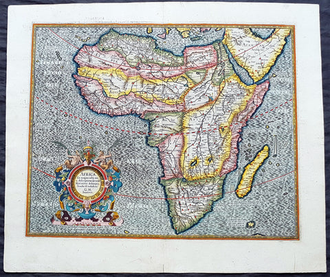
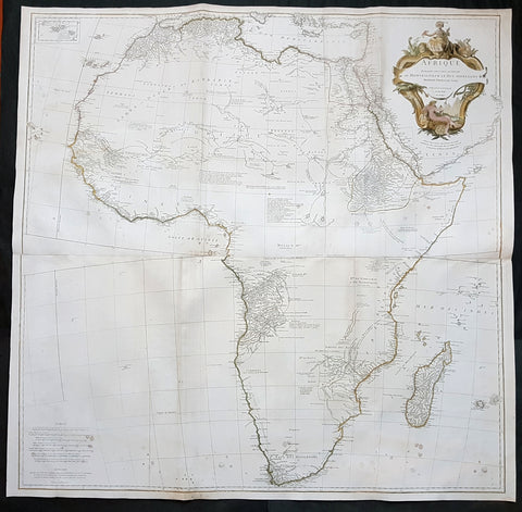
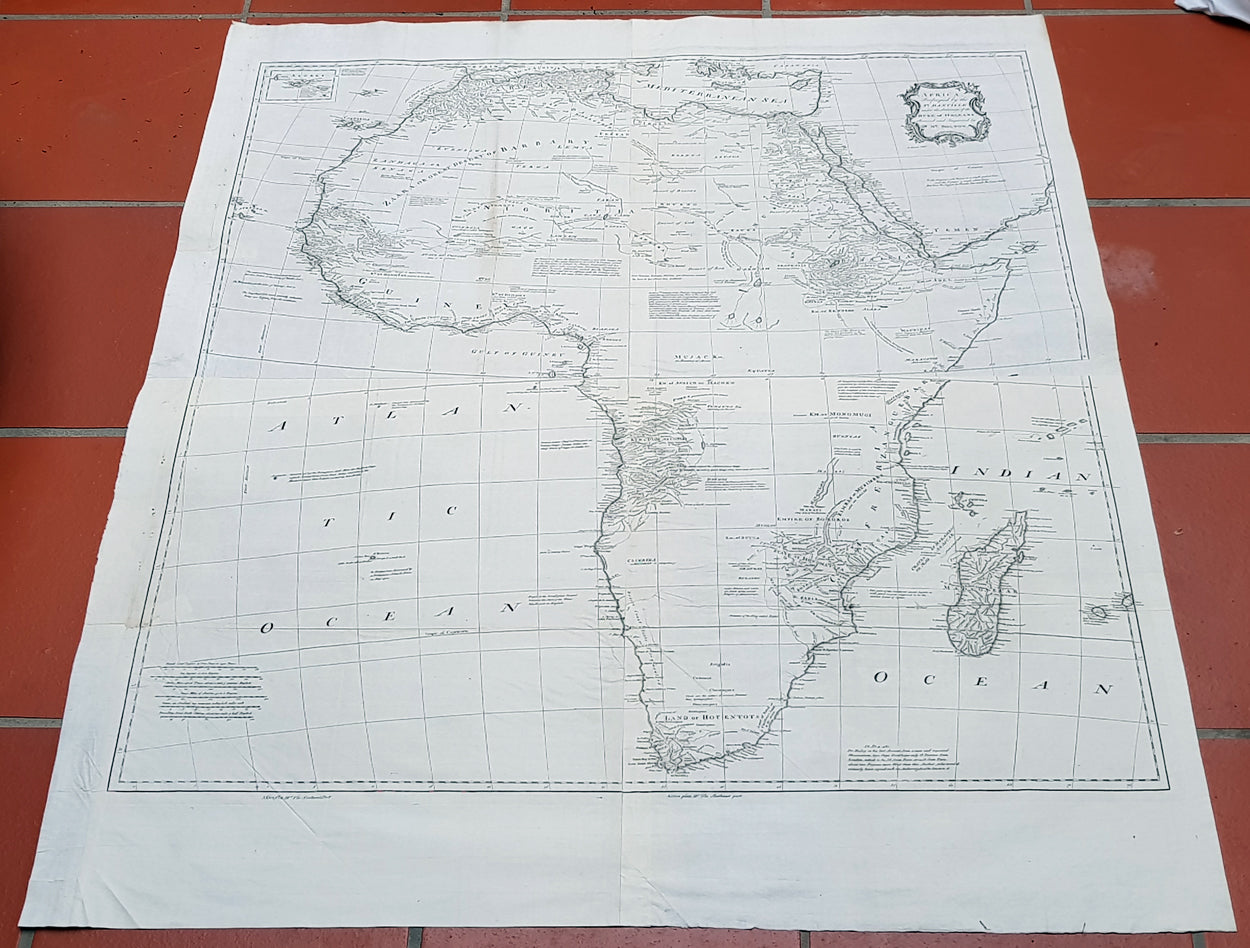
Description:This very large 4 sheet original copper plate engraved antique map of Africa by Solomon Bolton after the French cartographer Jean Baptiste Bourguignon D Anville, was engraved by Emmanuel Bowen and published in the 1765 edition of Malachy Postlethweyts monumental 2 Volume tomes on The Universal Dictionary of Trade & Commerce concentrating on various states of trade, including slavery, between England and America published between 1751 & 1774.Malachy Postlethweyt 1707 – 1767Malachy Postlethweyts Dictionary of Trade & Commerce:A monumental dictionary of trade and commerce. It is based in part on the Dictionnaire universel de Commerce (Paris: 1723-30) of Jacques Savary de Bruslon, under whose name it is often catalogued, but has been adapted by Postlethwayt for a British audience, with substantial enlargements and improvements, and entirely new material relating to England and her colonies. Postlethwayt devoted twenty years to the preparation of the dictionary, which was first published in 1751-55 & includes a description of British affairs in North America since the peace of 1763.As with his other works, the dictionary demonstrates Postlethway’s deep commitment to the expansion and strengthening of English trade. Included are entries for geographical locations (Africa, Antilles, Canada, Japan, Louisiana, &c.), products (brandy, cardamom, codfish, diamonds, sugar, &c.), trading companies (Dutch East India Company, English African Company, &c.), treaties of commerce, and a vast range of other information of value to merchants (bankruptcy, currency, bills of exchange, brokerage, exportation, landed interest, privateering, &c.). The Dictionary is also important for containing almost the whole substance of Richard Cantillons Essay on Commerce, its first appearance in print.
General Definitions:Paper thickness and quality: - Heavy and stablePaper color : - off whiteAge of map color: -Colors used: -General color appearance: -Paper size: - 47in x 41in (1.20m x 1.04m)Plate size: - 40in x 39in (1.10m x 990mm)Margins: - Min 1in (25mm)
Imperfections:Margins: - NonePlate area: - Light age toning left foldVerso: - None
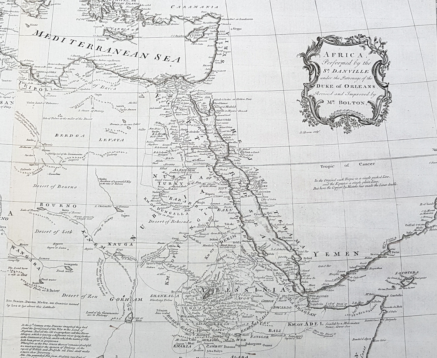
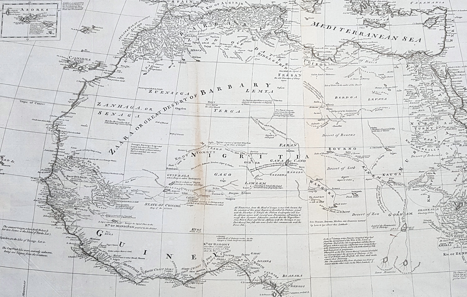
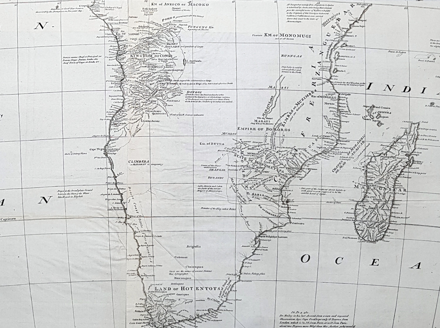
Background: This is one of the largest and most influential maps, of Africa, to appear in the mid-18th century. Engraved by Emmanuel Bowen after J.B. D Anville, the map covers the entire continent of Africa from the Mediterranean to the Cape of Good Hope and from the Cape Verde Islands to Madagascar. D Anville was a careful cartographer known for his scientific approach to map-making, and nowhere is this more evident than in this, one of his greatest and most innovative maps of Africa. Following the trajectory set by Guillaume de L Isle half a century earlier, D Anville takes a number of significant steps forward in addressing the confusions inherent in mapping this vast though mostly, in the mid-17th century, unexplored continent. These include unreliable cartographic suppositions regarding the African interior dating practically to antiquity. Many of these, including such speculative ideas as the Mountains of Kong, have been diminished if not removed entirely from this map, leaving vast unexplored areas throughout.What was known of Africa, however, D Anville incorporates here in an impressive compilation of the most up to date reports from colonial, missionary, and exploratory entradas into the interior of the continent. Thus well mapped parts of the continent are limited to the Mediterranean Coast, Morocco, the Senegambia, the Congo, South Africa, the Kingdom of Monomatapa, Abyssinia, and egypt. Morocco, egypt, and the southern Mediterranean Coast (Barbary) were well known to europeans since antiquity and D Anvilles accurate mapping of these regions reflects continual contact. Further south the colonial enclaves along the Niger River (Senegal and Gambia), the Congo River, and South Africa reflect considerable detail associated with European penetration by trader and missionaries. The land of Monomopota around the Zambezi River was explored early in the 16th century by the Portuguese in hopes that the legendary gold mines supposedly found there would counterbalance the wealth flowing into Spain from the New Word. Unfortunately these mines, often associated with the Biblical kingdom of Ophir, were mostly tapped out by the 15th century. Abyssinia (modern day ethiopia) was mapped in detail by early Italian missionaries and of considerable interest to Europeans first, because it was (and is) predominantly Christian; second, because it was a powerful well-organized and unified kingdom; and third because the sources of the Blue Nile were to be found here.The remainder of the continent remained largely speculative though D Anville rarely lets his imagination get the upper hand. He does however follow the well-established Ptolemaic model laid down in the Geographica regarding the sources of the White Nile – here seen as two lakes at the base of the semi-apocryphal Mountains of the Moon. However, he also presents a curious network of interconnected rivers extending westward from the confused course of the White Nile following the popular 18th century speculation that the Nile may be connected to the Niger. To his credit Anville does not advocate this and offers no true commerce between the two river systems.Lake Malawi, here identified as Maravi, appears in a long thin embryonic state that, though it had not yet been \\\'discovered,\\\' is remarkably accurate to form. Lake Malawi was not officially discovered until Portuguese trader Candido Jose da Costa Cardoso stumbled upon it in 1849 – one hundred years following Anvilles presentation of the lake here. Anvilles inclusion of Lake Malawi is most likely a prescient interpretation of indigenous reports brought to Europe by 17th century Portuguese traders. Its form would be followed by subsequent cartographers well into the mid-19th century when the explorations of John Hanning Speke, David Livingstone, Richard Francis Burton and others would at last yield a detailed study of Africas interior.