Welcome to Classical Images!
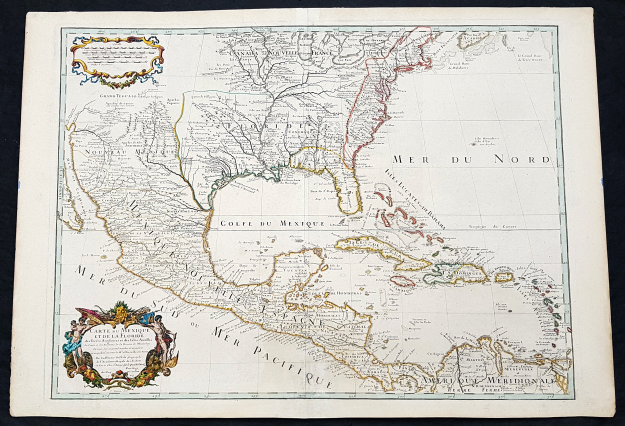
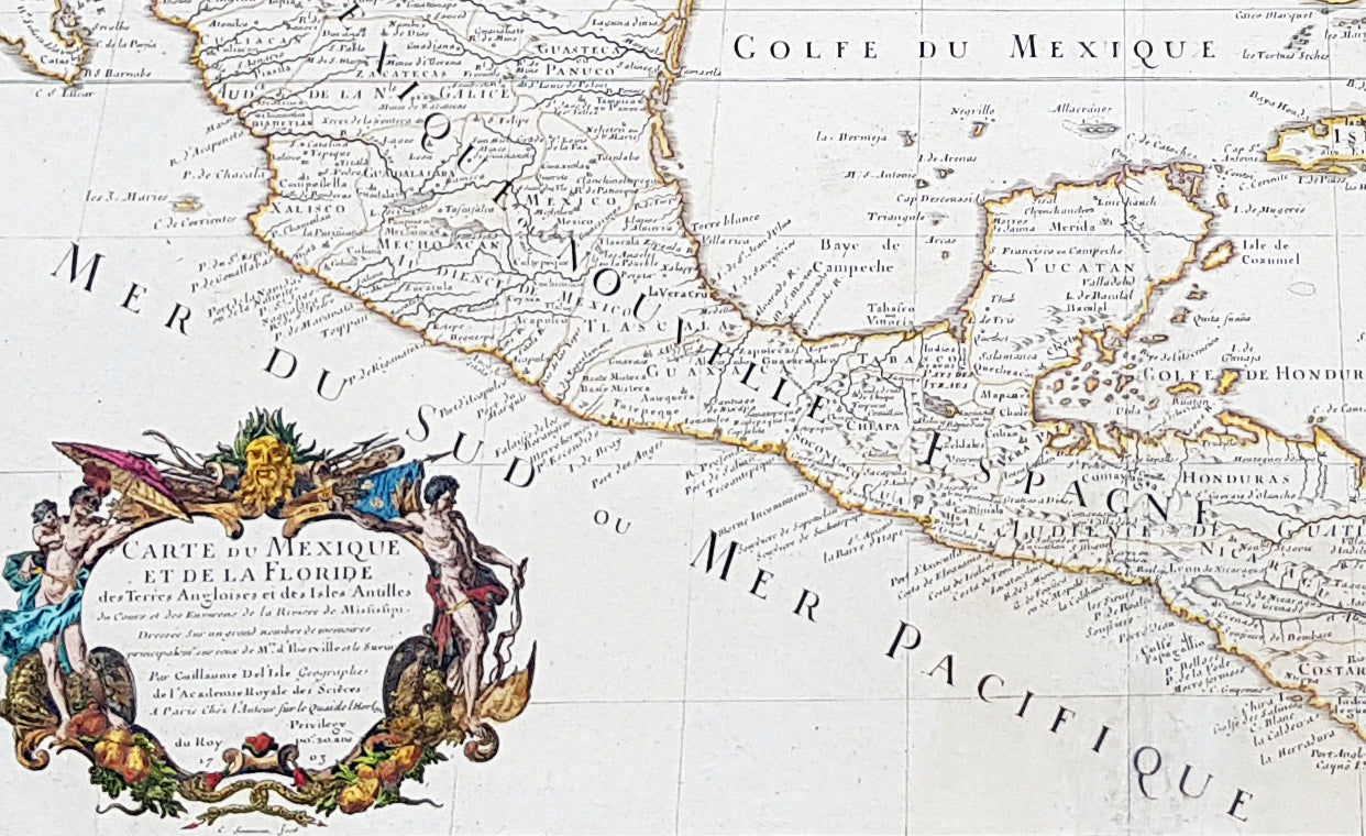
Description:In the world of early 18th century American cartography, no one published as many landmark maps of North America as the French family firm of Delisle. This large original copper-plate engraved scarce map of North America became one of the most copied map of the next 100 years by the likes of Homann, Seutter, Lotter, Sanson and many others. Engraved by Charles Simoneau, this map is the 4th state of seven (identified with the date 1703 in the cartouche with Delisles address in Paris erased) was published by Guillaume Delisle in the <i>Atlas Nouveau.</i>
The 7 states outlined by Tooley are:
- State 1 (1703): De LIsles first address on Rue Des Canettes.- State 2 (1703): address changed to Quai de lHorloge Couronne de Diamans and the imprint of Renard.- State 3 (1708): Couronne de Diamans is erased and <i>se trouve a Amsterdam chez L. Renard Libraire prez de la Bourse</i> is added- State 4 (1708): <i>A Paris Chez L Auteur sur le Quai de l Horloge</i> is added and <i>Couronne de Diamans and Renards</i> imprint are removed and the engravers name (Simoneau) appears below the cartouche.- State 5 (1722): <i>A Amsterdam Chez Jean Covens & Corneille Mortier avec Privilege 1722</i> Re-engraved and published by Covens & Mortier in Atlas Nouveau- State 6 (1745): Philippe Buache imprint added below neatline at right.- State 7 (1783): Title altered to Carte du Mexique et des Etas Unis dAmerique, Partie Meridionale, issued by Dezauche, showing US States and boundaries.
General Definitions:
Paper thickness and quality: - Heavy and stablePaper color : - off whiteAge of map color: - Original & laterColors used: - Yellow, green, blue, pinkGeneral color appearance: - AuthenticPaper size: - 29 1/4in x 20 1/2in (750mm x 520mm)Plate size: - 26in x 19 1/2in (660mm x 495mm)Margins: - Min 1in (20mm)
Imperfections:Margins: - NonePlate area: - NoneVerso: - None
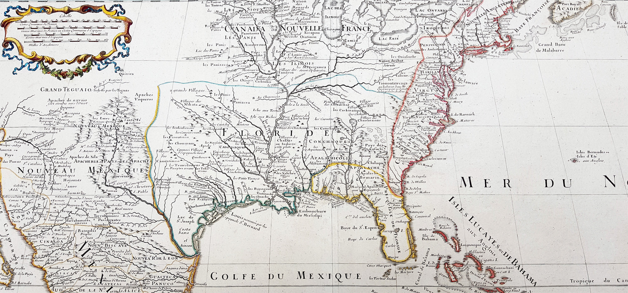
Background:This map, which is one of the three great maps of regional North America conceived by Delisle during the first quarter of the eighteenth century, identifies the colonial affiliations that defined the destiny of North America by the end of the century. As is often the case, the British North American Colonies are shown hemmed in by the Appalachians and crowding the Atlantic coast. The status of present-day South Carolina is dubious, the coloring implying that it may belong to Spain. To the north and west of New England, Canada confines the British colonies even further. In the Southwest, French Floride extends to the Rio Grande and south to present-day Brownsville. The northern boundary of Floride is indicated, except that it abuts Canada, thereby giving France possession of the entire middle part of the continent. Various remarks and locations for Native American tribes are shown, indicating, for example, the locations of the Apache Vaqueros, the Apache Navaio, and the Tiguas. In the French possessions many tribes and their villages are indicated, for example, the famous Cenis in Texas, the Apalache in Georgia and Florida, and the Kicapou near the Great Lakes (their original location before they were pushed all the way to Mexico). Delisles debts to Ibervilles explorations are frequently shown on this map.The map was compiled from the reports brought back to France from the survivors of the La Salle expedition into the interior of North America and from the information derived from the explorations of Bienville and dIberville. In the year preceding the publication of the map, De LIsle utilized his position with the King of France to gain access to the best available information from the new world. During this time period he assiduously compiled the geographical data from the reports of the French Jesuit Missionaries and Explorers in North America, along with Spanish manuscript maps (often copied by the Missionaries while they were acting in the service of the Spanish as spiritual guides and gaining their confidence).The result of this work were a series of landmark maps of the North America, including his map of North America ( LAmerique Septentrionale, 1700), Canada and the Great Lakes ( Carte du Canada ou de la Nouvelle France 1703), and the Mississippi Valley & Gulf Coast ( Carte de la Louisiane et du Cours du Mississipi 1708).The map has been a towering landmark along the path of Western cartographic development. De LIsles map also includes greater accuracy in the Great Lakes region and in its depiction of English settlements along the East Coast. Excellent detail of the Indian villages in East Texas, based upon the reports of dIberville and the Spanish missionaries. The best depiction of the Southwest to date, with early trails & Indian tribes. Cumming described the map as profoundly influential.Many have suggested that Claude Delisle, father of Guillaume, was the one who conducted the research on the maps, whereas Guillaume was the one who actually drew the maps and engraved the plates. Obviously the maps were a collaborative effort of the Delisle firm.