Welcome to Classical Images!
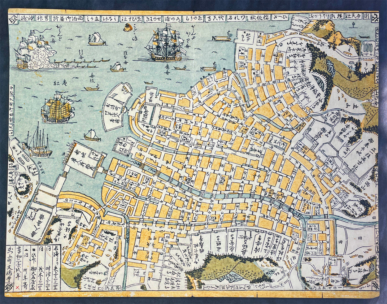
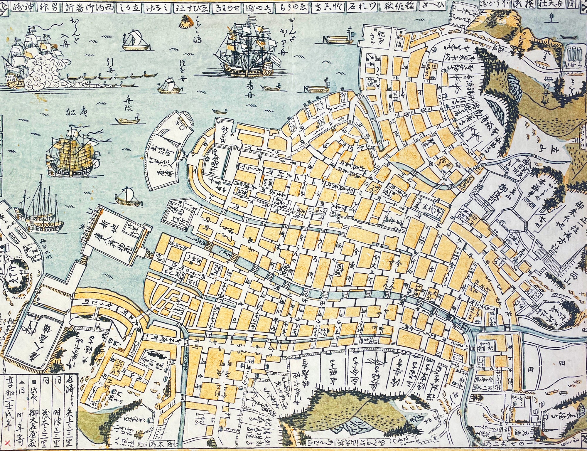
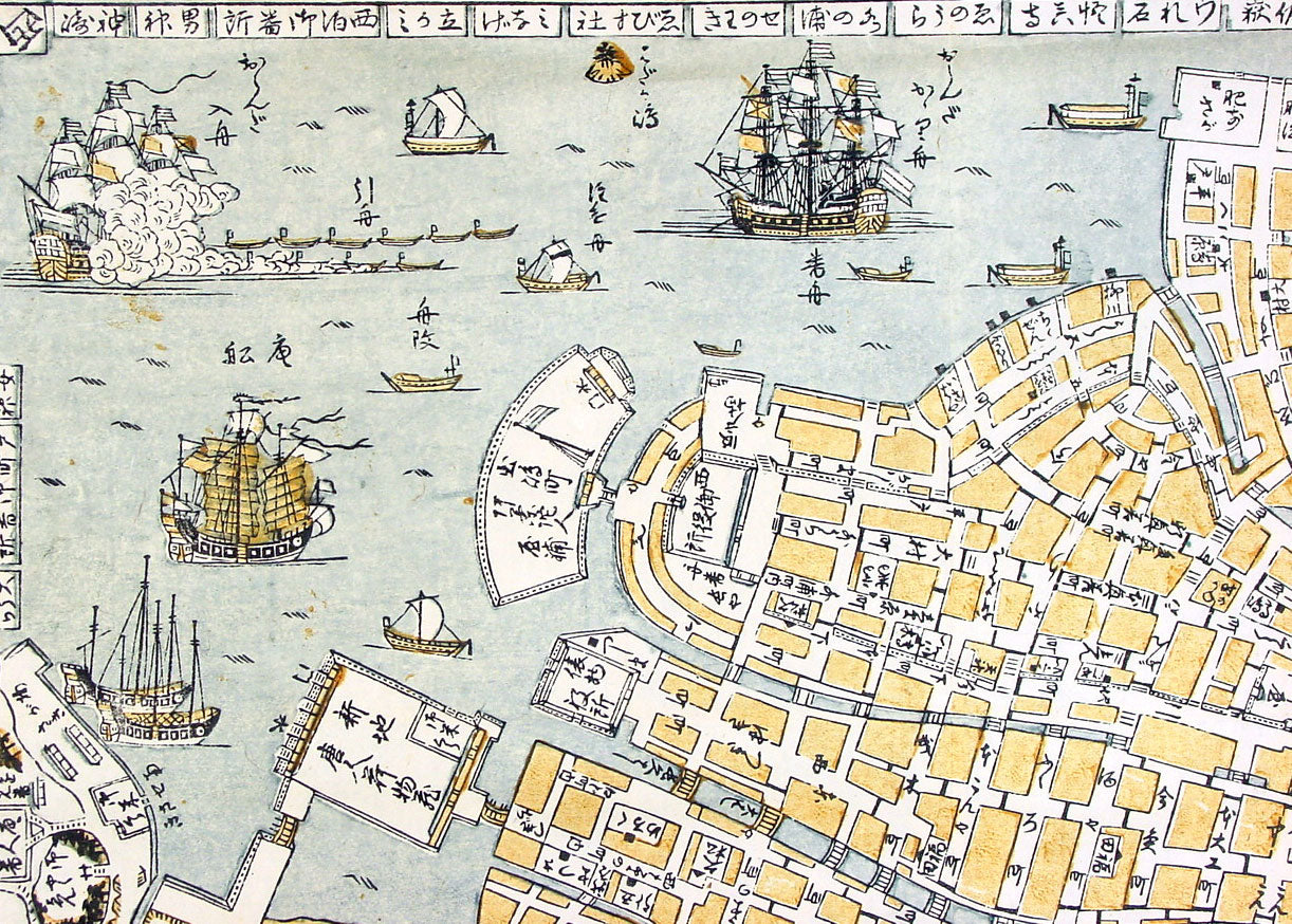
Description:Incredibly rare original hand coloured wood block engraved antique map of Nagasaki and Port (Nagasaki Zu) Japan by Kinbei Tadamasa was published in 1801.Kinbei Tadamasa was a Japanese cartographer and publisher who lived in Nagasaki during the Edo period (1603-1868). He was known for his maps of Nagasaki and the surrounding areas, as well as his publications on astronomy and geography.The Nagasaki Zu map depicts the city of Nagasaki as it appeared in the mid-18th century, including its streets, buildings, and landmarks. The map is oriented with north to the right, and is presented in a bird's-eye view format, which was common for maps of Japanese cities during this time. The map also includes a key to important locations in the city, such as temples, shrines, and government buildings.Nagasaki Zu is considered an important historical document, as it provides a detailed view of Nagasaki during a time of significant cultural exchange between Japan and the West. Nagasaki was one of the few Japanese ports open to foreign trade during the Edo period, and as a result, it became an important center for the exchange of ideas and goods between Japan, China, and Europe. The map depicts the presence of Western-style buildings and fortifications in the city, reflecting the influence of European and Chinese traders on the local culture.Today, Nagasaki Zu is held in the collections of several museums and libraries in Japan, including the Nagasaki City Museum and the National Diet Library. It is a valuable resource for scholars and historians studying the history and culture of Nagasaki and Japan during the Edo period.
General Definitions:Paper thickness and quality: - Heavy and stablePaper color : - off whiteAge of map color: - OriginalColors used: - Blue, yellow, greenGeneral color appearance: - AuthenticPaper size: - 17 1/2in x 13 1/2in (445mm x 343mm)Plate size: - 17 1/2in x 13 1/2in (445mm x 343mm)Margins: - Min 0in (0mm)
Imperfections:Margins: - NonePlate area: - NoneVerso: - None
Background:During the 18th and 19th centuries, Japanese cartographers continued to produce maps of Nagasaki, reflecting the citys growth and changes over time.One notable example of 18th century Japanese cartography of Nagasaki is the Nagasaki Zu or Map of Nagasaki, created by a Japanese cartographer named Kinbei Tadamasa in 1801. The map was produced using traditional Japanese cartographic techniques and features detailed illustrations of the citys streets, buildings, and landmarks. The map also includes annotations in Japanese, indicating the locations of various temples, shrines, and other landmarks.Another important map of Nagasaki is the Nagasaki Ezu or Map of Nagasaki, created by a Japanese cartographer named Yamanouchi Tatsunosuke in 1853. The map was produced using a combination of traditional Japanese and Western cartographic techniques and features detailed illustrations of the citys streets, buildings, and waterways. The map also includes annotations in both Japanese and Dutch, indicating the locations of various landmarks and buildings.In the late 19th century, the Japanese government began to adopt Western-style cartographic techniques, resulting in the production of maps such as the Nagasaki-shi Eiri Chizu or Map of Nagasaki City, created by the Geographical Survey Institute in 1893. The map was produced using a combination of Western and Japanese cartographic techniques and features a more modern, topographical view of the city.These maps of Nagasaki provide valuable insight into the history and development of the city, as well as the evolution of Japanese cartographic techniques over time. They offer a unique perspective on the citys layout, architecture, and landmarks during the 18th and 19th centuries, reflecting the changes that occurred as Nagasaki became an important center of trade and commerce.
Tadamasa, KinbeiKinbei Tadamasa was a Japanese cartographer, astronomer, and publisher who lived in Nagasaki during the Edo period (1603-1868). He was born in 1729 in Nagasaki and worked as a surveyor and astronomer for the Nagasaki Domain. Tadamasa is known for his detailed maps of Nagasaki and its surrounding areas, as well as his publications on astronomy and geography.In 1775, Tadamasa published his most famous work, "Nagasaki Zu," a detailed map of the city of Nagasaki. The map is oriented with north to the right and presented in a bird's-eye view format, which was common for maps of Japanese cities during this time. It is considered an important historical document as it provides a detailed view of Nagasaki during a time of significant cultural exchange between Japan and the West.Tadamasa was also a prominent publisher and bookseller, and his shop, Bunkindo, became well known for its publications on astronomy, geography, and literature. Tadamasa's publications were known for their high quality and accuracy, and he was recognized as an important figure in the development of scientific knowledge and cartography in Japan during the Edo period.Today, Tadamasa's maps and publications are held in the collections of several museums and libraries in Japan, including the Nagasaki City Museum and the National Diet Library. He is considered one of the most important cartographers and publishers of his time, and his work remains an important resource for scholars and historians studying the history and culture of Japan during the Edo period.
Please note all items auctioned are genuine, we do not sell reproductions. A Certificate of Authenticity (COA) can be issued on request.