Welcome to Classical Images!
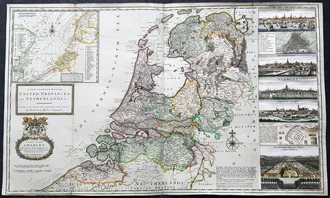
Description:This large magnificent hand coloured original copper-plate engraved antique map of the German State of Westphalia by Robert De Vaugondy was published in the 1757 edition of De Vaugondys famous The Atlas Universel
General Definitions:Paper thickness and quality: - Heavy and stablePaper color : - off whiteAge of map color: - Original & laterColors used: - Blue, pink, red, green, yellowGeneral color appearance: - AuthenticPaper size: - 26in x 20in (660mm x 510mm)Plate size: - 25in x 19in (635mm x 485mm)Margins: - Min 1/2in (10mm)
Imperfections:Margins: - NonePlate area: - NoneVerso: - None
Background: Westphalia is a region in northwestern Germany and one of the three historic parts of the state of North Rhine-Westphalia.Westphalia is known for the 1648 Peace of Westphalia which ended the Thirty Years War, as the two treaties were signed in Münster and Osnabrück.It is one of the regions that were part of all incarnations of the German state since the Early Middle Ages: the Holy Roman Empire, the Confederation of the Rhine, the German Confederation, the North German Confederation, the German Empire, the Weimar Republic and National Socialist Germany. After World War II it was a part of the British occupation zone which merged with the American zone to become the Bizone in 1947 and again merged with the French zone to become the Trizone in 1948. The current Federal Republic of Germany was founded on these territories making Westphalia a part of West Germany. It is a part of united Germany since 1990.Along with Eastphalia, Angria and Nordalbingia, Westphalia (Westfalahi) was originally a district of the Duchy of Saxony. At the time, large portions of its territory in the north lay in what today is Lower Saxony. Following the deposition of the Saxon duke Henry the Lion in 1180 and the subsequent belittlement of the duchy, Westphalia was elevated to a duchy in its own right by Emperor Barbarossa. The Duchy of Westphalia comprised only a small area south of the Lippe River.Modern Westphalia was a part of the Lower Rhenish–Westphalian Circle of the Holy Roman Empire, which comprised territories of Lower Lorraine, Frisia and parts of the former Duchy of Saxony.As a result of the Protestant Reformation, there was no dominant religion in Westphalia. Roman Catholicism and Lutheranism were on a relatively equal footing. Lutheranism was strong in the eastern and northern parts with numerous free churches. Münster and especially Paderborn were thought of to be Catholic. Osnabrück was divided almost equally between Catholicism and Protestantism.Parts of Westphalia came under Brandenburg-Prussian control during the 17th and 18th centuries, but most of it remained divided by duchies and other areas of feudal power. The Peace of Westphalia of 1648, signed in Münster and Osnabrück, ended the Thirty Years\' War. The concept of nation-state sovereignty resulting from the treaty became known as Westphalian sovereignty.