Welcome to Classical Images!
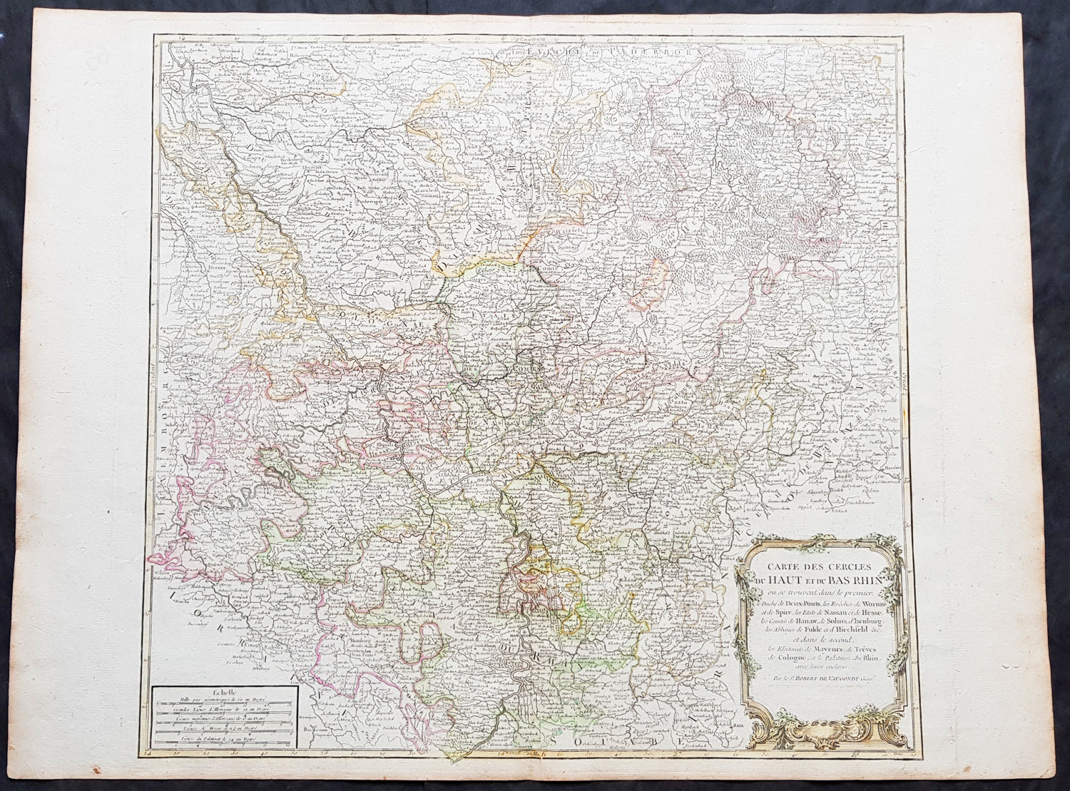
Description:This large magnificent hand coloured original copper-plate engraved antique map of part of Western Germany centering on the Rhine River and the cities of Bonn & Cologne, today the North Rhine-Westphalia by Robert De Vaugondy was published in the 1757 edition of De Vaugondys famous The Atlas Universel
General Definitions:Paper thickness and quality: - Heavy and stablePaper color : - off whiteAge of map color: - Original & laterColors used: - Blue, pink, red, green, yellowGeneral color appearance: - AuthenticPaper size: - 26 1/2in x 19 3/4in (670mm x 505mm)Plate size: - 21 1/2in x 19in (550mm x 480mm)Margins: - Min 1/2in (10mm)
Imperfections:Margins: - NonePlate area: - NoneVerso: - None
Background: North Rhine-Westphalia is located in western Germany covering an area of 34,084 square kilometres and a population of 17.6 million, the most populous and the most densely populated German state apart from the city-states of Berlin, Bremen, and Hamburg, and the fourth-largest by area. Düsseldorf is the state capital and Cologne is the largest city. North Rhine-Westphalia features four of Germany\'s 10 largest cities: Düsseldorf, Cologne, Dortmund, and Essen, and the Rhine-Ruhr metropolitan area, the largest in Germany and the third-largest on the European continent.Around AD 1, numerous incursions occurred through Westphalia and perhaps even some permanent Roman or Romanized settlements. The Battle of Teutoburg Forest took place near Osnabrück (as mentioned, whether this is in Westphalia is disputed) and some of the Germanic tribes who fought at this battle came from the area of Westphalia. Charlemagne is thought to have spent considerable time in Paderborn and nearby parts. His Saxon Wars also partly took place in what is thought of as Westphalia today. Popular legends link his adversary Widukind to places near Detmold, Bielefeld, Lemgo, Osnabrück, and other places in Westphalia. Widukind was buried in Enger, which is also a subject of a legend.Along with Eastphalia and Engern, Westphalia (Westfalahi) was originally a district of the Duchy of Saxony. In 1180, Westphalia was elevated to the rank of a duchy by Emperor Barbarossa. The Duchy of Westphalia comprised only a small area south of the Lippe River.Parts of Westphalia came under Brandenburg-Prussian control during the 17th and 18th centuries, but most of it remained divided duchies and other feudal areas of power. The Peace of Westphalia of 1648, signed in Münster and Osnabrück, ended the Thirty Years\' War. The concept of nation-state sovereignty resulting from the treaty became known as Westphalian sovereignty.As a result of the Protestant Reformation, there is no dominant religion in Westphalia. Roman Catholicism and Lutheranism are on relatively equal footing. Lutheranism is strong in the eastern and northern parts with numerous free churches. Münster and especially Paderborn are thought of as Catholic. Osnabrück is divided almost equally between Catholicism and Protestantism.After the defeat of the Prussian Army at the Battle of Jena-Auerstedt, the Treaty of Tilsit in 1807 made the Westphalian territories part of the Kingdom of Westphalia from 1807 to 1813. It was founded by Napoleon and was a French vassal state. This state only shared the name with the historical region; it contained only a relatively small part of Westphalia, consisting instead mostly of Hessian and Eastphalian regions.After the Congress of Vienna, the Kingdom of Prussia received a large amount of territory in the Westphalian region and created the province of Westphalia in 1815. The northernmost portions of the former kingdom, including the town of Osnabrück, had become part of the states of Hanover and Oldenburg.The state of North Rhine-Westphalia was established by the British military administration\'s \"Operation Marriage\" on 23 August 1946, by merging the province of Westphalia and the northern parts of the Rhine Province, both being political divisions of the former state of Prussia within the German Reich. On 21 January 1947, the former state of Lippe was merged with North Rhine-Westphalia. The constitution of North Rhine-Westphalia was then ratified through a referendum.