Welcome to Classical Images!
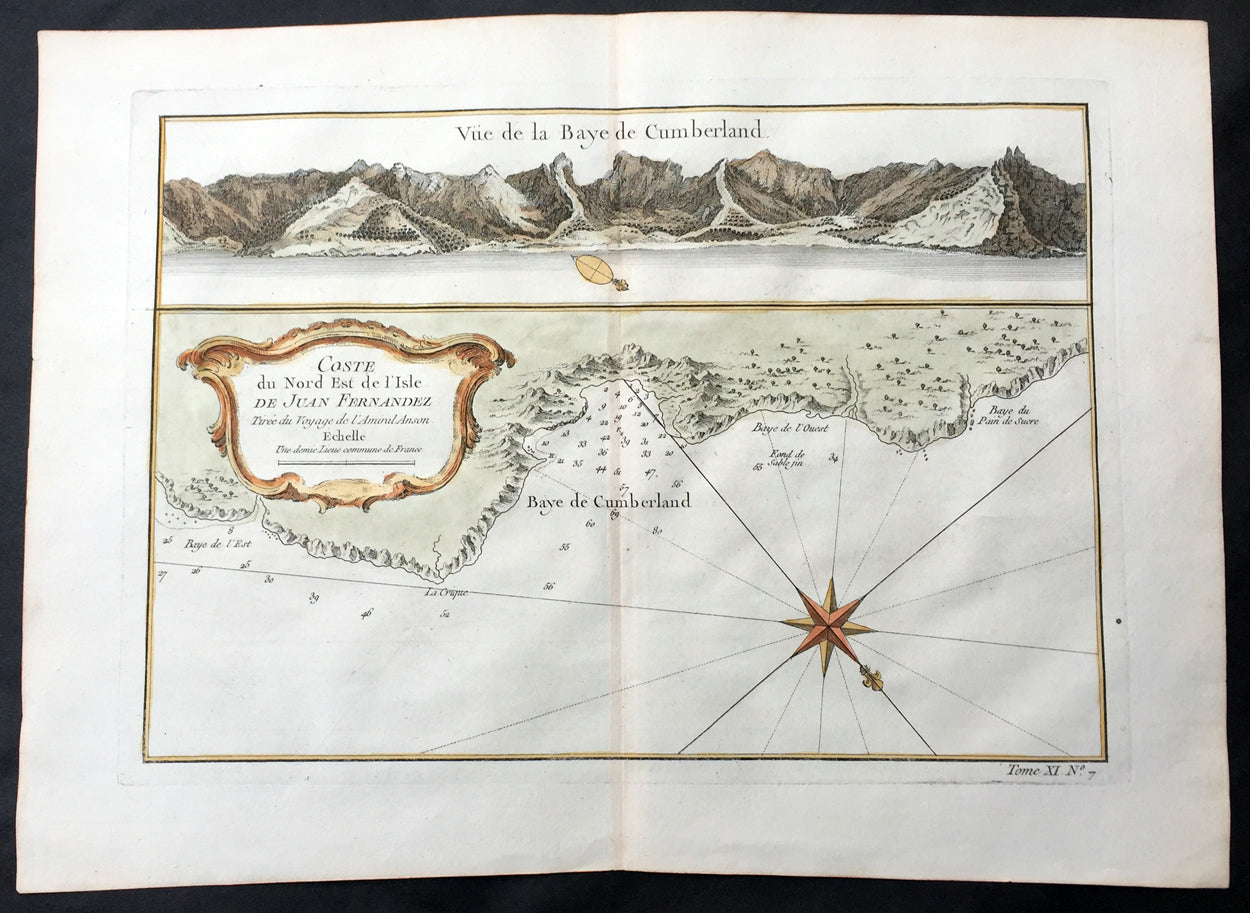
Description:This fine, original copper-plate engraved antique map of map & view of Cumberland Bay and the Capital San Juan Bautista in the NE of Juan Fernandez Island - off the coast of Chile in the Pacific Ocean - the home of the castaway Alexander Selkirk for 4 years - by Jacques Nicolas Bellin in 1755 was published in Antoine François Prevosts 15 volumes of Histoire Generale des Voyages written by Prevost & other authors between 1746-1790.Alexander Selkirk (1676 - 1721) was a Scottish sailor who spent four years as a castaway when he was marooned on an uninhabited island, Juan Fernández Island off the coast of Chile. It is his travels that provided the inspiration for Daniel Defoe\'s novel Robinson Crusoe.At an early period he was engaged in buccaneer expeditions to the South Seas and in 1703 joined in with the expedition of famed privateer and explorer William Dampier. While Dampier was captain of the St. George, Selkirk served on the galley Cinque Ports, the St. George\'s companion, as a sailing master serving under Thomas Stradling.In October 1704, after the ships had parted ways because of a dispute between Stradling and Dampier, the Cinque Ports was brought by Stradling to the uninhabited archipelago of Juan Fernández off the coast of Chile for a mid-expedition restocking of supplies and fresh water. Selkirk had grave concerns by this time about the seaworthiness of this vessel (indeed, the Cinque Ports later foundered, losing most of its hands). He tried to convince some of his crewmates to desert with him, remaining on the island; he was counting on an impending visit by another ship. No one else agreed to come along with him. Stradling declared that he would grant him his wish and leave him alone on Juan Fernández. Selkirk promptly regretted his decision. He chased and called after the boat, to no avail. Selkirk lived the next four years and four months without any human company. All he had brought with him was a musket, gunpowder, carpenter\'s tools, a knife, a Bible, some clothing and rope.His long-anticipated rescue occurred on 1 February 1709 by way of the Duke, a privateering ship piloted by the above-mentioned William Dampier. Selkirk was discovered by the Duke\'s captain, Woodes Rogers, who referred to him as Governor of the island. Now rescued, he was almost incoherent in his joy. The agile Selkirk, catching two or three goats a day, helped restore the health of Rogers\' men. Rogers eventually made Selkirk his mate, giving him independent command of one of his ships. Rogers\' A cruising voyage round the world: first to the South-Sea, thence to the East-Indies, and homewards by the Cape of Good Hope was published in 1712 and included an account of Selkirk\'s ordeal. (Ref: Tooley; M&B)
General Definitions:Paper thickness and quality: - Heavy and stablePaper color : - off whiteAge of map color: - EarlyColors used: - Green, yellow, orangeGeneral color appearance: - AuthenticPaper size: - 14in x 10in (355mm x 255mm)Plate size: - 12in x 8 1/2in (305mm x 215mm)Margins: - Min 1/2in (12mm)
Imperfections:Margins: - NonePlate area: - NoneVerso: - None
Background: One of Antoine Francois Prevosts monumental undertakings was his history of exploration & discovery in 15 volumes titledHistoire Générale des Voyages written between 1746-1759 and was extended to 20 volumes after his death by various authors.The 20 volumes cover the early explorations & discoveries on 3 continents: Africa (v. 1-5), Asia (v. 5-11), and America (v. 12-15) with material on the finding of the French, English, Dutch, and Portugese.A number of notable cartographers and engravers contributed to the copper plate maps and views to the 20 volumes including Nicolas Bellin, Jan Schley, Chedel, Franc Aveline, Fessard, and many others.The African volumes cover primarily coastal countries of West, Southern, and Eastern Africa, plus the Congo, Madagascar, Arabia and the Persian Gulf areas.The Asian volumes cover China, Korea, Tibet, Japan, Philippines, and countries bordering the Indian Ocean.Volume 11 includes Australia and Antarctica.Volumes 12-15 cover voyages and discoveries in America, including the East Indies, South, Central and North America.Volumes 16-20 include supplement volumes & tables along with continuation of voyages and discoveries in Russia, Northern Europe, America, Asia & Australia.