
John Thomson (1814 - 1869)
Profile :
John Thomson produced two major works in his life time, A New General atlas of the World, 1814-28 and Atlas of Scotland1820-32. The maps from A New General atlas of the World were printed in full hand coloring from large copperplate engravings. The level of detail at the time of publication was heralded as a breakthrough in British cartography and Thompson rightly earned a great deal of attention and his work copied for a number of years
John Thomson (6)
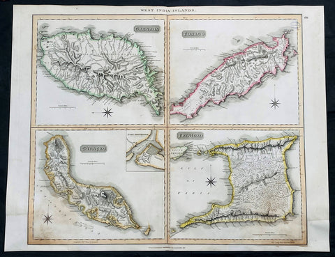
1816 John Thompson Large Antique Map Grenada, Tobago, Curacao Trinidad Caribbean
Antique Map
- Title : West India Islands: Grenada; Tobago; Curacao; Trinadad.
- Date : 1816
- Size: 27in x 21in (685mm x 535mm)
- Condition: (A) Very Good Condition
- Ref: 35612
Description:
This large original, beautifully hand coloured copper plate engraved antique map of the Caribbean Islands Grenada, Tobago, Curacao & Trinidad was published by John Thomson in his large elephant folio 1817 edition of A New General Atlas of the World. (Ref Tooley M&B)
General Definitions:
Paper thickness and quality: - Heavy and stable
Paper color : - off white
Age of map color: - Original
Colors used: - Yellow, green, blue, pink
General color appearance: - Authentic
Paper size: - 27in x 21in (685mm x 535mm)
Plate size: - 27in x 21in (685mm x 535mm)
Margins: - Min 1/2in (12mm)
Imperfections:
Margins: - Bottom L&R margins extended from borders, not affecting the image
Plate area: - Light age toning, small library stamp to right
Verso: - Age toning
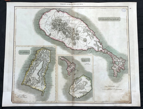
1817 John Thompson Large Antique Map Caribbean Is. St Christopher St Lucia Nevis
Antique Map
- Title : West India Islands: St Christopher; St Lucia; Nevis
- Date : 1817
- Size: 27in x 21in (685mm x 535mm)
- Condition: (A) Very Good Condition
- Ref: 35609
Description:
This large original, beautifully hand coloured copper plate engraved antique map of the Caribbean Islands was published by John Thomson in his large elephant folio 1817 edition of A New General Atlas of the World. (Ref Tooley M&B)
General Definitions:
Paper thickness and quality: - Heavy and stable
Paper color : - off white
Age of map color: - Original
Colors used: - Yellow, green, blue, pink
General color appearance: - Authentic
Paper size: - 27in x 21in (685mm x 535mm)
Plate size: - 27in x 21in (685mm x 535mm)
Margins: - Min 1/2in (12mm)
Imperfections:
Margins: - Bottom L&R margins extended from borders, not affecting the image
Plate area: - Light age toning, small library stamp to right
Verso: - Age toning
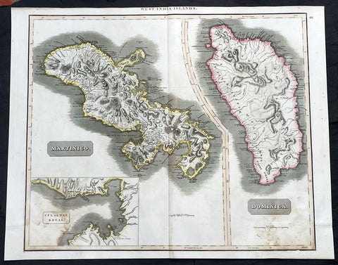
1817 John Thompson Large Antique Map Caribbean Islands of Martinique & Dominica
Antique Map
- Title : West India Islands: Martinico (Cul de Sac Royal); Dominica
- Date : 1817
- Size: 27in x 21in (685mm x 535mm)
- Condition: (A) Very Good Condition
- Ref: 35606
Description:
This large original, beautifully hand coloured copper plate engraved antique map of the Caribbean Islands of Martinique and Dominica was published by John Thomson in his large elephant folio 1817 edition of A New General Atlas of the World. (Ref Tooley M&B)
General Definitions:
Paper thickness and quality: - Heavy and stable
Paper color : - off white
Age of map color: - Original
Colors used: - Yellow, green, blue, pink
General color appearance: - Authentic
Paper size: - 27in x 21in (685mm x 535mm)
Plate size: - 27in x 21in (685mm x 535mm)
Margins: - Min 1/2in (12mm)
Imperfections:
Margins: - Bottom L&R margins extended from borders, not affecting the image
Plate area: - Light age toning
Verso: - Age toning
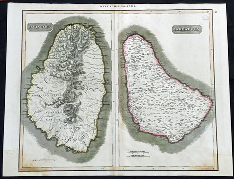
1817 John Thompson Large Antique Map Caribbean Islands of St Vincent & Barbados
Antique Map
- Title : West India Islands: St Vincent; Barbados
- Date : 1817
- Size: 27in x 21in (685mm x 535mm)
- Condition: (A) Very Good Condition
- Ref: 35610
Description:
This large original, beautifully hand coloured copper plate engraved antique map of the Caribbean Islands was published by John Thomson in his large elephant folio 1817 edition of A New General Atlas of the World. (Ref Tooley M&B)
General Definitions:
Paper thickness and quality: - Heavy and stable
Paper color : - off white
Age of map color: - Original
Colors used: - Yellow, green, blue, pink
General color appearance: - Authentic
Paper size: - 27in x 21in (685mm x 535mm)
Plate size: - 27in x 21in (685mm x 535mm)
Margins: - Min 1/2in (12mm)
Imperfections:
Margins: - Bottom L&R margins extended from borders, not affecting the image
Plate area: - Light age toning, small library stamp to right
Verso: - Age toning
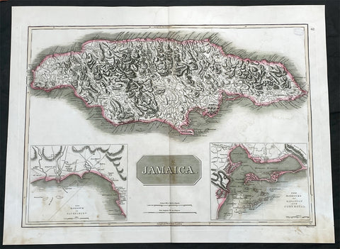
1817 John Thompson Large Antique Map of the Caribbean Island of Jamaica
Antique Map
- Title : Jamaica
- Date : 1817
- Size: 27in x 21in (685mm x 535mm)
- Condition: (A) Very Good Condition
- Ref: 35605
Description:
This large original, beautifully hand coloured copper plate engraved antique map of the Caribbean Islands was published by John Thomson in his large elephant folio 1817 edition of A New General Atlas of the World. (Ref Tooley M&B)
General Definitions:
Paper thickness and quality: - Heavy and stable
Paper color : - off white
Age of map color: - Original
Colors used: - Yellow, green, blue, pink
General color appearance: - Authentic
Paper size: - 27in x 21in (685mm x 535mm)
Plate size: - 27in x 21in (685mm x 535mm)
Margins: - Min 1/2in (12mm)
Imperfections:
Margins: - Light age toning
Plate area: - Light age toning, small library stamp to right
Verso: - Age toning
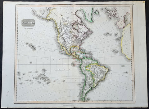
1817 John Thomson Large Antique Map of North & South America, Hawaiian Islands
- Title : America...Drawn & Engraved for Thomsons New General Atlas
- Date : 1817
- Size: 28in x 21 1/2in (710mm x 550mm)
- Condition: (A+) Fine Condition
- Ref: 35020
Description:
This large magnificent original hand coloured copper-plate engraved antique map of America drawn & engraved by John Thomson was published in the 1817 edition of Thomsons General Atlas
General Definitions:
Paper thickness and quality: - Heavy and stable
Paper color : - off white
Age of map color: - Original
Colors used: - Yellow, green, blue, pink
General color appearance: - Authentic
Paper size: - 28in x 21 1/2in (710mm x 550mm)
Plate size: - 25in x 20in (635mm x 510mm)
Margins: - Min 1in (25mm)
Imperfections:
Margins: - None
Plate area: - None
Verso: - None
Background:
The exploration of North America by non-indigenous people was a continuing effort to map and explore the continent of North America. It spanned centuries, and consisted of efforts by numerous people and expeditions from various foreign countries to map the continent. The European colonization of the Americas followed.
There were numerous Spanish explorers and conquistadors who explored the Southwest of North America (including present-day west and central United States) and cross the continent (east to west) in its southern regions, mainly from the second quarter to the middle of the 16th century, such as Álvar Núñez Cabeza de Vaca and Francisco Vásquez de Coronado, but also the North American Southeast and south-central regions, s Soto]].
In 1608 Samuel de Champlain founded what is now Quebec City, which would become the first permanent settlement and the capital of New France. He took personal administration over the city and its affairs, and sent out expeditions to explore the interior. Champlain himself discovered Lake Champlain in 1609. By 1615, he had travelled by canoe up the Ottawa River through Lake Nipissing and Georgian Bay to the centre of Huron country near Lake Simcoe. During these voyages, Champlain aided the Wendat (aka Hurons) in their battles against the Iroquois Confederacy. As a result, the Iroquois would become enemies of the French and be involved in multiple conflicts.
From 1679 to 1682 René-Robert Cavelier, Sieur de La Salle explored the Great Lakes region of the United States and Canada, and the entire course of Mississippi River to the Gulf of Mexico.
From 1697 to 1702 Eusebio Kino explored the Sonoran Desert and on his journey to the Colorado River Delta discovered an overland route to Baja California that was then commonly believed to be an island. In 1683 Kino lead the first European overland crossing of Baja California.
European exploration of western Canada was largely motivated by the fur trade and the search for the elusive Northwest Passage. Hudson\'s Bay Company explorer Henry Kelsey has the distinction of being the first European to see the northern Great Plains in 1690.
Anthony Henday was the first to have seen the Rocky Mountains, in 1754, but curiously did not mention it in his journals. From his westernmost geographic position (roughly near the town of Olds, Alberta, halfway between Calgary and Red Deer, Alberta) the Rockies should have been quite conspicuous, but he was likely trying to disguise the disappointing fact that an unknown range of seemingly impassible mountains now stood between the HBC and the Pacific. Samuel Hearne found the Coppermine River in 1769-71 in his failed search for copper ore deposits. Burned by these shortfalls, the HBC largely quit exploration.
The North West Company, on the other hand, used a business model that required constant expansion into untapped areas. Under the auspices of the NWC, Alexander Mackenzie discovered the Mackenzie River in 1789 and was the first European to reach the North-American Pacific overland, via the Bella Coola River, in 1793. Simon Fraser reached the Pacific in 1808 via the Fraser River.
David Thompson, widely regarded as the greatest land geographer that ever lived, traveled over 90,000 km during his lifetime. In 1797, Thompson was sent south by his employers to survey part of the Canada-U.S. boundary along the water routes from Lake Superior to Lake of the Woods to satisfy unresolved questions of territory arising from the Jay Treaty between Great Britain and the United States. By 1798 Thompson had completed a survey of 6,750 km (4,190 mi) from Grand Portage, through Lake Winnipeg, to the headwaters of the Assiniboine and Mississippi Rivers, as well as two sides of Lake Superior. In 1798, the company sent him to Red Deer Lake (in present-day Alberta) to establish a trading post. The English translation of Lac La Biche-Red Deer Lake-first appeared on the Mackenzie map of 1793. Thompson spent the next few seasons trading based in Fort George (now in Alberta), and during this time led several expeditions into the Rocky Mountains. In 1811/1812 he followed the Columbia River to the Pacific, and in 1814 used his notes and measurements to draft the first European-style map of western Canada, covering 3.9 million square kilometres.
Lewis and Clark were the first Americans to venture into the newly acquired territory of the Louisiana Purchase, at the order of President Thomas Jefferson. They discovered many new geographical features, Indian tribes, and animal and plant species. John Colter was a member of the expedition who subsequently became a guide for others in the Old West, and did some explorations of his own.
John C. Frémont led many important explorations in the Great Plains, Great Basin, Oregon territory, and Mexican Alta California.
Joseph Reddeford Walker was one of the most prominent of the explorers, and charted many new paths through the West, which often were then utilized by emigrants crossing to settle in Western towns and communities. In 1833, his exploring party discovered a route along the Humboldt River across present-day Nevada, ascending the Sierra Nevada following the Carson River and descending via Stanislaus River drainages to Monterey. His return route across the southern Sierra was via Walker Pass, named after Walker by John Charles Fremont. The approach of the Sierra via the Carson River route later became known as the California Trail, the primary route for the emigrants to the gold fields during the California gold rush.
As the American population of the West increased, the US government launched ongoing official explorations mainly through the US Army Corps of Topographical Engineers. One of the main officers and explorers in this unit was George Wheeler. In 1872, the US Congress authorized an ambitious plan to map the portion of the United States west of the 100th meridian at a scale of 8 miles to the inch. This plan necessitated what became known as the Wheeler Survey, along with the Clarence King and John Wesley Powell Surveys, and expeditions by Ferdinand Vandeveer Hayden. In 1879, all such efforts were reorganized as the United States Geological Survey.