
John Senex (1690- 1740)
Profile : Publisher and engraver, Senex, was a contemporary of the cartographer Herman Moll and no doubt, to some extent, a rival although his output was rather smaller. In conjunction with Charles Price and James Maxwell he produced some fine maps of the world and the continents as well as loose maps of various countries (1708-14).
Apart from these maps he seems to have had a particular interest in road maps and in 1719 he issued a corrected edition of Ogilby's Britannia in miniature with updated road maps of England and Wales.
John Senex (1)
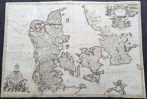
1720 John Senex Large Antique Map of Denmark & Southern Sweden
Antique Map
- Title : Denmark Corrected from the Newest Observations of the Royal Society at London and Paris by John Senex FRS
- Size: 38 1/2in x 27in (965mm x 685mm)
- Condition: (A) Very Good Condition
- Date : 1720
- Ref #: 70706
Description:
This large hand coloured original antique map of Denmark was engraved by John Senex and was published in the 1720 edition of his Elephant Folio Atlas.
This map is in VG condition. These large scale maps are scarce due mainly to their size, with damage and loss over time inevitable.
General Definitions:
Paper thickness and quality: - Heavy and stable
Paper color : - off white
Age of map color: - Original
Colors used: - Yellow, green, blue, pink
General color appearance: - Authentic
Paper size: - 38 1/2in x 27in (965mm x 685mm)
Plate size: - 38in x 26 1/2in (960mm x 680mm)
Margins: - Min 1/4in (6mm)
Imperfections:
Margins: - Chipping to bottom margin
Plate area: - Light offsetting
Verso: - Light creasing
Background:
Before the fifteenth century the people of Southern Europe had little geographical knowledge of the Scandinavian World except from sketchy detail shown in the Catalan Atlas (1375) and on a number of \" portolani\" embracing Denmark and the southern tip of Norway. It was not until 1427 that a manuscript map prepared about that time by Claudius Clavus (b.1388) a Dane who spent some time in Rome, made available to scholars a tolerable outline of the northern countries and Greenland. That was to remain the best map available for the rest of the century and it was used as the basis for maps of Scandinavia in early printed editions of Ptolemy. Others by Nicolaus Cusanus (1491) and Ehrhard Etzlaub (c. 1492) followed but, needless to say, these are extremely rare; even the later maps by Olaus Magnus and Marcus Jordan, where they have survived at all , are known only by a very few examples. In fact, apart from the rare appearance of an early Ptolemy map, the oldest of Scandinavia which a collector is likely to find are those of Munster\'s Cosmograhy first published in 1544. In the following centuries the few maps and charts complied in Scandinavia were usually published in Amsterdam, Antwerp, Paris or Nuremberg, the most important maps often being incorporated in the major Dutch, French & German Atlases. (Ref: Tooley; M&B)