
John Senex (1690- 1740)
Profile : Publisher and engraver, Senex, was a contemporary of the cartographer Herman Moll and no doubt, to some extent, a rival although his output was rather smaller. In conjunction with Charles Price and James Maxwell he produced some fine maps of the world and the continents as well as loose maps of various countries (1708-14).
Apart from these maps he seems to have had a particular interest in road maps and in 1719 he issued a corrected edition of Ogilby's Britannia in miniature with updated road maps of England and Wales.
John Senex (10)

1710 John Senex Large Antique Map of Germany, Central Europe, Baltic to Austria
Antique Map
- Title : Germany Corrected from the Observations of the Royal Society at London and the Royal Academy at Paris by John Senex FRS....1710
- Size: 41in x 26 1/2in (1.040m x 660mm)
- Condition: (A) Very Good Condition
- Date : 1710
- Ref #: 24906
Description:
This large hand coloured original antique map of Germany was engraved by John Senex in 1710 - dated - and was published in Senex Elephant Folio Atlas.
This map is in VG condition, with these large scale maps being scarce due mainly to their size with damage and loss over time inevitable.
General Definitions:
Paper thickness and quality: - Heavy and stable
Paper color : - off white
Age of map color: - Original
Colors used: - Yellow, green, blue, pink
General color appearance: - Authentic
Paper size: - 41in x 26 1/2in (1.040m x 660mm)
Plate size: - 40in x 26in (1.00m x 650mm)
Margins: - Min 1/2in (12mm)
Imperfections:
Margins: - Chipping to bottom margin
Plate area: - Age toning along centerfold, light creasing
Verso: - Light creasing.
Background:
Because of Germanys long history as a non-united region of distinct tribes and states before January 1871, there are many widely varying names of Germany in different languages, perhaps more so than for any other European nation. For example, in the German language, the country is known as Deutschland, in Spanish as Alemania, in French as Allemagne, in Italian as Germania (although Germans are called tedeschi), in Polish as Niemcy, and in Finnish as Saksa.
In 800, the Frankish king Charlemagne was crowned emperor and founded the Carolingian Empire, which was later divided in 843 among his heirs. Following the break up of the Frankish Realm, for 900 years, the history of Germany was intertwined with the history of the Holy Roman Empire, which subsequently emerged from the eastern portion of Charlemagnes original empire. The territory initially known as East Francia stretched from the Rhine in the west to the Elbe River in the east and from the North Sea to the Alps. The Ottonian rulers (919–1024) consolidated several major duchies and the German king Otto I was crowned Holy Roman Emperor of these regions in 962. In 996 Gregory V became the first German Pope, appointed by his cousin Otto III, whom he shortly after crowned Holy Roman Emperor. The Holy Roman Empire absorbed northern Italy and Burgundy under the reign of the Salian emperors (1024–1125), although the emperors lost power through the Investiture controversy.
In the 12th century, under the Hohenstaufen emperors (1138–1254), German princes increased their influence further south and east into territories inhabited by Slavs; they encouraged German settlement in these areas, called the eastern settlement movement (Ostsiedlung). Members of the Hanseatic League, which included mostly north German cities and towns, prospered in the expansion of trade. In the south, the Greater Ravensburg Trade Corporation (Große Ravensburger Handelsgesellschaft) served a similar function. The edict of the Golden Bull issued in 1356 by Emperor Charles IV provided the basic constitutional structure of the Empire and codified the election of the emperor by seven prince-electors who ruled some of the most powerful principalities and archbishoprics.
Population declined in the first half of the 14th century, starting with the Great Famine in 1315, followed by the Black Death of 1348–50. Despite the decline, however, German artists, engineers, and scientists developed a wide array of techniques similar to those used by the Italian artists and designers of the time who flourished in such merchant city-states as Venice, Florence and Genoa. Artistic and cultural centres throughout the German states produced such artists as the Augsburg painters Hans Holbein and his son, and Albrecht Dürer. Johannes Gutenberg introduced moveable-type printing to Europe, a development that laid the basis for the spread of learning to the masses.
In 1517, the Wittenberg priest Martin Luther nailed the Ninety-Five Theses to the church door, challenging the practice of selling of indulgences. He was subsequently excommunicated in the papal bull Exsurge Domine in 1520, and his followers were condemned in the 1521 Diet of Worms, which divided Western Christianity. In 1555, the Peace of Augsburg tolerated the Evangelical faith (now called Lutheranism) as an acceptable alternative to Catholicism, but also decreed that the faith of the prince was to be the faith of his subjects, a principle called cuius regio, eius religio. The agreement at Augsburg failed to address other religious creed: for example, the Reformed faith was still considered a heresy and the principle did not address the possible conversion of an ecclesiastic ruler, such as happened in Electorate of Cologne in 1583. However, in practice Calvinists were given protection under the Augsburg Confession Variata modified upon request by Philip Melanchthon.
From the Cologne War until the end of the Thirty Years Wars (1618–1648), religious conflict devastated German lands. The latter reduced the overall population of the German states by about 30 per cent, and in some places, up to 80 per cent. The Peace of Westphalia ended religious warfare among the Imperial Estates of the Holy Roman Empire. Their mostly German-speaking rulers were able to choose either Roman Catholicism, Lutheranism, or the Reformed faith as their official religion after 1648.
In the 18th century, the Holy Roman Empire consisted of approximately 1,800 territories. The elaborate legal system initiated by a series of Imperial Reforms (approximately 1450–1555) created the Imperial Estates and provided for considerable local autonomy among ecclesiastical, secular, and hereditary states, reflected in the Imperial Diet. The House of Habsburg held the imperial crown from 1438 until the death of Charles VI in 1740. Having no male heirs, he had convinced the Electors to retain Habsburg hegemony in the office of the emperor by agreeing to the Pragmatic Sanction of 1713. This was finally settled through the War of Austrian Succession; in the Treaty of Aix-la-Chapelle, Charles VIs daughter Maria Theresa ruled the Empire as Empress Consort when her husband, Francis I, became Holy Roman Emperor. From 1740, the dualism between the Austrian Habsburg Monarchy and the Kingdom of Prussia dominated the German history.
In 1772, then again in 1793 and 1795, the two dominant German states of Prussia and Austria, along with the Russian Empire, agreed to the Partitions of Poland; dividing among themselves the lands of the Polish–Lithuanian Commonwealth. As a result of the partitions, millions of Polish speaking inhabitants fell under the rule of the two German monarchies. However, the annexed territories though incorporated into the Kingdom of Prussia and the Habsburg Realm, were not legally considered as a part of the Holy Roman Empire. During the period of the French Revolutionary Wars, along with the arrival of the Napoleonic era and the subsequent final meeting of the Imperial Diet, most of the secular Free Imperial Cities were annexed by dynastic territories; the ecclesiastical territories were secularised and annexed. In 1806 the Imperium was dissolved; many German states, particularly the Rhineland states, fell under the influence of France. Until 1815, France, Russia, Prussia and the Habsburgs (Austria) competed for hegemony in the German states during the Napoleonic Wars.
Following the fall of Napoleon, the Congress of Vienna (convened in 1814) founded the German Confederation (Deutscher Bund), a loose league of 39 sovereign states. The appointment of the Emperor of Austria as the permanent president of the Confederation reflected the Congresss failure to accept Prussias rising influence among the German states, and acerbated the long-standing competition between the Hohenzollern and Habsburg interests. Disagreement within restoration politics partly led to the rise of liberal movements, followed by new measures of repression by Austrian statesman Metternich. The Zollverein, a tariff union, furthered economic unity in the German states.
National and liberal ideals of the French Revolution gained increasing support among many, especially young, Germans. The Hambach Festival in May 1832 was a main event in support of German unity, freedom and democracy. In the light of a series of revolutionary movements in Europe, which established a republic in France, intellectuals and commoners started the Revolutions of 1848 in the German states. King Frederick William IV of Prussia was offered the title of Emperor, but with a loss of power; he rejected the crown and the proposed constitution, leading to a temporary setback for the movement.
Foundation of the German Empire in Versailles, 1871. Bismarck is at the centre in a white uniform.
King William I appointed Otto von Bismarck as the new Minister President of Prussia in 1862. Bismarck successfully concluded war on Denmark in 1864, which promoted German over Danish interests in the Jutland peninsula. The subsequent (and decisive) Prussian victory in the Austro-Prussian War of 1866 enabled him to create the North German Confederation (Norddeutscher Bund) which excluded Austria from the federations affairs. After the French defeat in the Franco-Prussian War, the German princes proclaimed the founding of the German Empire in 1871 at Versailles, uniting all the scattered parts of Germany except Austria and the German-speaking parts of Switzerland. Prussia was the dominant constituent state of the new empire; the Hohenzollern King of Prussia ruled as its concurrent Emperor, and Berlin became its capital.
In the Gründerzeit period following the unification of Germany, Bismarcks foreign policy as Chancellor of Germany under Emperor William I secured Germanys position as a great nation by forging alliances, isolating France by diplomatic means, and avoiding war. Under Wilhelm II, Germany, like other European powers, took an imperialistic course, leading to friction with neighbouring countries. Most alliances in which Germany had previously been involved were not renewed. This resulted in the creation of a dual alliance with the multinational realm of Austria-Hungary, promoting at least benevolent neutrality if not outright military support. Subsequently, the Triple Alliance of 1882 included Italy, completing a Central European geographic alliance that illustrated German, Austrian and Italian fears of incursions against them by France and/or Russia. Similarly, Britain, France and Russia also concluded alliances that would protect them against Habsburg interference with Russian interests in the Balkans or German interference against France.
At the Berlin Conference in 1884, Germany claimed several colonies including German East Africa, German South West Africa, Togoland, and Kamerun. Later, Germany further expanded its colonial empire to include German New Guinea, German Micronesia and German Samoa in the Pacific, and Kiautschou Bay in China. In what became known as the First Genocide of the Twentieth-Century, between 1904 and 1907, the German colonial government in South West Africa (present-day Namibia) ordered the annihilation of the local Herero and Namaqua peoples, as a punitive measure for an uprising against German colonial rule. In total, around 100,000 people—80% of the Herero and 50% of the Namaqua—perished from imprisonment in concentration camps, where the majority died of disease, abuse, and exhaustion, or from dehydration and starvation in the countryside after being deprived of food and water.
The assassination of Austrias crown prince on 28 June 1914 provided the pretext for the Austrian Empire to attack Serbia and trigger World War I. After four years of warfare, in which approximately two million German soldiers were killed, a general armistice ended the fighting on 11 November, and German troops returned home. In the German Revolution (November 1918), Emperor Wilhelm II and all German ruling princes abdicated their positions and responsibilities. Germanys new political leadership signed the Treaty of Versailles in 1919. In this treaty, Germany, as part of the Central Powers, accepted defeat by the Allies in one of the bloodiest conflicts of all time. Germans perceived the treaty as humiliating and unjust and it was later seen by historians as influential in the rise of Adolf Hitler. After the defeat in the First World War, Germany lost around 13% of its European territory (areas predominantly inhabited by ethnic Polish, French and Danish populations, which were lost following the Greater Poland Uprising, the return of Alsace-Lorraine and the Schleswig plebiscites), and all of its colonial possessions in Africa and the South Sea.
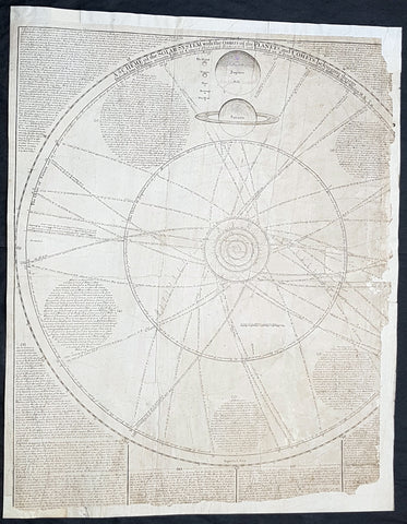
1712 J Senex & W Whiston Large Antique Astronomy Print of Planets & Solar System
Antique Map
- Title : A Scheme of the Solar System with the Orbits of the Planets and Comets belonging thereto, Described from Dr. Halley\'s accurate Table of Comets Philosoph, Transact. No. 297. Founded on Sr. Isaac Newton\'s wonderful discoveries By Wm. Whiston M.A.
- Size: 27in x 21in (585mm x 520mm)
- Condition: (B) Good Condition
- Date : 1712
- Ref #: 80773
Description:
This large original important copper plate engraved antique map of the Planets & Solar System according to Edmund Halley, Isaac Newton & William Whiston by John Senex in 1712, was published in his Elephant Folio Atlas.
This map is rare and is unfortunately damaged, not unusual for these large maps. Approx 4in strip from the left side of the map & approx 1in from the bottom of the map is missing and has been mounted on contemporary 18th century paper. Still the majority of the map remains and is still a fascinating look into our knowledge of Solar System at the beginning of the 18th century. At the moment there a couple for sale online selling for between $1500 - $5000
General Definitions:
Paper thickness and quality: - Heavy and stable
Paper color : - off white
Age of map color: -
Colors used: -
General color appearance: -
Paper size: - 27in x 21in (585mm x 520mm)
Plate size: - 27in x 21in (585mm x 520mm)
Margins: - Min 1/2in (12mm)
Imperfections:
Margins: - Approx 4in strip from the left side of the map is missing
Plate area: - Two repairs to top of image
Verso: - Repairs as noted
Background:
A large and impressive chart of the solar system, paying particular attention to the motions of the planetary bodies and the paths of comets. The chart was originally engraved in 1712 by Senex to accompany the lectures of the controversial theologian, astronomer, and polymath William Whiston. The chart was issued again in 1720 by Senex alone, and finally by Bowles and Sayer in the 1760s. The System is shown as a number of concentric orbits with the Sun at centre, criss-crossed by the broad elliptical paths of a number of comets. At top, the planets are shown pictorially, clumped together in an attempt to demonstrate scale. As the chart was engraved at the beginning of the eighteenth century, the outer planets past Saturn are not included. Earths moon is accorded an honorary spot among the planets, while the moons of the other planets are shown in the grand scheme as Satellites. The alchemical symbols for the zodiac are included along the outside ring of the System, and the chart is absolutely covered by explanatory text.
William Whiston (1667-1752) was an English mathematician, theologian, historian and religious writer. Born in Leicestershire, Whiston was a leading figure in popularising the ideas of Sir Issac Newton, who was his mentor and teacher. Whiston was a professor of mathematics at the University of Cambridge but was expelled from his position in 1710 due to his unorthodox religious beliefs and views. Whiston was a believer of Arianism, the idea that Christ is subordinate to God, the concept of Christ is based on the belief that the Son of God did not always exist but was begotten by God the Father. He also rejected the notion of eternal torment in hellfire. What especially placed him against church authorities, was he viewed the Trinity as a lie after extensive personal research convinced him the origin of the Trinity teaching to be pagan. Whiston wrote A New Theory of the Earth, published in 1696, in which he presented a description of the divine creation of the Earth, postulating that the earth originated from the atmosphere of a comet.
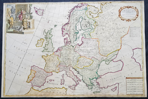
1712 John Senex Large Antique Map of Europe - Iceland, Poland, Russia, Italy
- Title : Europe Corrected from ye Observations Communicated to the Royal Society of London and Paris By John Senex & John Maxwell. Geographer to The Queen
- Size: 38in x 25 1/2in (970mm x 645mm)
- Condition: (A+) Fine Condition
- Date : 1712
- Ref #: 50657
Description:
This extraordinary, rare very large & beautifully hand coloured original antique map* of Europe - showing the Political Boundaries of the early 18th century - by John Senex & John Maxwell was published in the 1712 edition of their large Elephant Folio General Atlas. The map is dedicated to Sir Richard Child of Wansted Ist Earl of Tynley and Essex.
These large scale maps are scarce as damage and loss over time was frequent from both handling and difficulty storing safely.
General Definitions:
Paper thickness and quality: - Heavy and stable
Paper color : - off white
Age of map color: - Original & later
Colors used: - Yellow, green, blue, pink
General color appearance: - Authentic
Paper size: - 38in x 25 1/2in (970mm x 645mm)
Plate size: - 37in x 25in (930mm x 635mm)
Margins: - Min 1/4in (5mm)
Imperfections:
Margins: - Light soiling in margins
Plate area: - Light soiling along bottom of image, light creasing along foldsFolds as issued
Verso: - Light soiling in margins
Background:
A very interesting and scarce map of Europe at the beginning of the 18th century reflecting a continent before war and upheaval. The Ottoman Empire is still well entrenched stretching north to the southern borders of Austria & Hungary. Poland extends from the Baltic to the Black Sea encompassing much of SE Europe bordering Russia. Germany and Italy are shown as large extended countries on the map but were in truth made up of many large and small parochial states and Kingdoms. Overall a fantastic large and fascinating map entering a century of great upheaval. (Ref: Tooley; M&B)
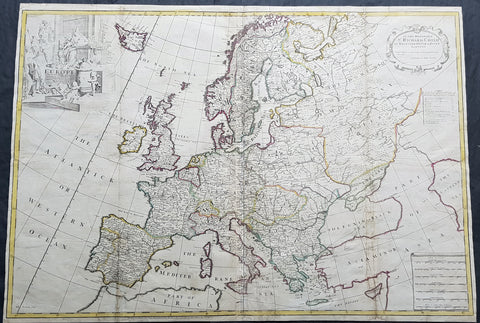
1712 John Senex Large Antique Map of Europe - Large Poland, Russia, Italy, Spain
- Title : Europe Corrected from ye Observations Communicated to the Royal Society of London and Paris By John Senex, Geographer to The Queen
- Size: 35 1/2in x 26in (900mm x 660mm)
- Condition: (A) Very Good Condition
- Date : 1712
- Ref #: 70707
Description:
This extraordinary, rare very large & beautifully hand coloured original copper-plate engraved antique map of Europe - showing the Political Boundaries of the early 18th century - by John Senex was published in the 1712 edition of his large Elephant Folio General Atlas. The map is dedicated to Sir Richard Child of Wansted Ist Earl of Tynley and Essex.This map is in VG condition. These large scale maps are scarce due mainly to their size, with damage and loss over time inevitable.
General Definitions:
Paper thickness and quality: - Heavy and stable
Paper color : - off white
Age of map color: - Original
Colors used: - Yellow, green, blue, pink
General color appearance: - Authentic
Paper size: - 35 1/2in x 26in (900mm x 660mm)
Plate size: - 35 1/2in x 26in (900mm x 660mm)
Margins: - Min 1/2in (12mm)
Imperfections:
Margins: - Several small repairs to margins
Plate area: - Soiling to & several professional repairs to folds
Verso: - Soiling
Background:
A very interesting and scarce map of Europe at the beginning of the 18th century reflecting a continent before war and upheaval. The Ottoman Empire is still well entrenched stretching north to the southern borders of Austria & Hungary. Poland extends from the Baltic to the Black Sea encompassing much of SE Europe bordering Russia. Germany and Italy are shown as large extended countries on the map but were in truth made up of many large and small parochial states and Kingdoms. Overall a fantastic large and fascinating map entering a century of great upheaval. (Ref: Tooley; M&B)
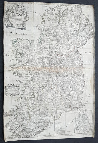
1712 John Senex Large Original Antique Map of Ireland
- Title : Ireland Corrected from the Latest Observations....by John Senex FRS....London 1712
- Size: 38 1/2in x 26in (980mm x 660mm)
- Condition: (B) Good Condition
- Date : 1712
- Ref #: 22573
Description:
This large original copper plate engraved antique map of Ireland by John Senex, was engraved in 1712 - dated - as a large stand alone map.
These large scale maps are scarce due mainly to their size, with damage and loss over time inevitable.
General Definitions:
Paper thickness and quality: - Heavy and stable
Paper color : - off white
Age of map color: -
Colors used: -
General color appearance: -
Paper size: - 38 1/2in x 26in (980mm x 660mm)
Plate size: - 38 1/2in x 26in (980mm x 660mm)
Margins: - Min 1in (25mm)
Imperfections:
Margins: - Soiling and chipping to margins, cropped to border
Plate area: - Light soiling, light browning along centerfold
Verso: - Original canvas backing
Background:
The earliest maps of Ireland up to the year 1500 or so share the shortcomings of those of the rest of the British Isles especially as represented on world maps. It was not to be expected that lands literally on the very edge of the known world could be depicted with any accuracy; very often one feels that the cartographers or engravers placed the islands in the nearest available space consistent with their imagined position. Even in the first printed Ptolemaic map there is still much distortion in Ireland\\\'s shape and geographical position but, on the other hand, a quite surprising number of place names and other details are shown, as many, in fact, as in the rest of Britain put together. This detailed knowledge is not as puzzling as it might appear, for the Ptolemy maps, at least the later editions from 1513 onwards, were based on Italian portulan charts and these, in turn, reflected knowledge gained during the long commercial relationship which had existed between Italy and Ireland ever since the thirteenth century. The distortions on land-surveyed maps remained uncorrected until late in the seventeenth century but a quite accurate coastal outline was given in the marine atlases of Waghenaer, Dudley, Blaeu and later Dutch chart makers.
Apart from a few manuscript maps and very rare maps printed in Rome and Venice (George Lily, 1546, and others in the period 1560-66) Ireland is shown on Mercator\\\'s large map of the British Isles (1564), and in his Atlas (1595) and as a separate sheet in the Ortelius atlases (from 1 573). The most important map, however, was compiled by an Italian, Baptista Boazio, probably in the 1 5 8os. This has survived in manuscript form and may have been used by Pieter van der Keere for a map published by Jodocus Hondius in 1591. Boazio\\\'s map was subsequently published by John Sudbury, who later sold Speed\\\'s maps, and this version was included in editions of the Ortelius atlases from 6oz onwards. The Boazio map is a quite splendid map, very decorative, some copies even showing an Eskimo complete with kayak and hunting spear. Thereafter the trend is familiar: Camden, Speed, Blaeu, Jansson, Sanson and others of the Dutch and French schools all included a general map or maps of the Irish provinces in their atlases. Speed\\\'s map of the whole of Ireland was based at least partly on surveys by Robert Lythe (c.1570) and Francis Jobson (c.1590) and included figures in national costume; it was for long regarded as the best map available and was much copied by publishers in other countries.
In 1685 the first atlas of Ireland to match Saxton\\\'s At/as of Eng/andand Wales was published by Sir William Petty as Hiberniae Detineaho, the result of a highly organized and detailed survey (the \\\'Down\\\' survey) carried out in the years following 1655. Re-issued in miniature form soon afterwards by Francis Lamb, Petty\\\'s Atlas was widely used as the basis for practically all maps of Ireland produced by English, French, Dutch and German publishers in the following century. Apart from re-issues of Petty\\\'s Atlas and its many copyists there were maps by George Grierson, a Dublin publisher, John Rocque, the Huguenot surveyor and engraver who spent some years in Dublin, and Bernard Scale, Rocque\\\'s brother-in-law.
Towards the end of the century many large-scale maps were published but, as in England, private mapping was gradually overtaken and eventually replaced by the Ordnance Survey maps produced between the years 1824 and 1846.(Ref: Koeman, Tooley)
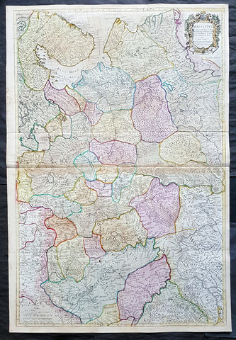
1712 Senex Large Original Antique Map of Europe Russia, Moscow - Finland to Azov
Antique Map
- Title : Moscovy Corrected from ye Observations Communicated to the Royal Society of London and Paris By John Senex & John Maxwell. Sold by them at the Globe.....1712
- Ref #: 82074
- Size: 39 1/2in x 26 1/2in (980mm x 675mm)
- Date : 1712
- Condition: (A) Very Good Condition
Description:
This extraordinary, very large & beautifully hand coloured original antique map of European Russia - Moscovy - including parts of Scandinavia, the Baltic States & The Ukraine by John Senex & John Maxwell in 1712 - dated in title - and was published for Senex's large Elephant Folio General Atlas.
These large scale maps are scarce as damage and loss over time was frequent from both handling and difficulty storing safely.
Background: It is scarcely necessary to look at a map of Russia - with which we must include Siberia - to visualize the daunting task facing Russian map makers. Indeed, considering the vastness of their territory and the lack of skilled cartographers, it is surprising that relatively good maps were available for engraving and printing in most of the well known sixteenth and seventeenth century atlases. Generally, maps of that time were based on material brought back from Moscow by visitors from the West. (Ref: Tooley; M&B)
General Description:
Paper thickness and quality: - Heavy and stable
Paper color: - white
Age of map color: - Original & later
Colors used: - Yellow, green, blue, red
General color appearance: - Authentic
Paper size: - 39 1/2in x 26 1/2in (980mm x 675mm)
Plate size: - 37in x 25in (930mm x 635mm)
Margins: - min. 1/2in (12mm)
Imperfections:
Margins: - None
Plate area: - Light age toning along centerfold & top of image
Verso: - Folds re-enforced on verso
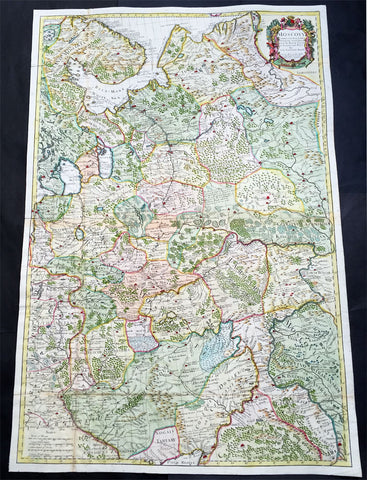
1712 Senex Very Large Antique Map of European Russia - Moscovy Corrected
Antique Map
- Title : Moscovy Corrected from ye Observations Communicated to the Royal Society of London and Paris By John Senex & John Maxwell. Sold by them at the Globe.....1712
- Ref #: 61030
- Size: 38in x 27in (990mm x 665mm)
- Date : 1712
- Condition: (A) Very Good Condition
Description:
This extraordinary, very large & beautifully hand coloured original antique map of European Russia - Moscovy - including parts of Scandinavia, the Baltic States & The Ukraine by John Senex & John Maxwell in 1712 - dated in title - and was published for Senex's large Elephant Folio General Atlas.
These large scale maps are scarce as damage and loss over time was frequent from both handling and difficulty storing safely.
General Description:
Paper thickness and quality: - Heavy and stable
Paper color: - white
Age of map color: - Original & later
Colors used: - Yellow, green, blue, red
General color appearance: - Authentic
Paper size: - 38in x 27in (990mm x 665mm)
Plate size: - 37in x 25in (930mm x 635mm)
Margins: - min. 1/2in (12mm)
Imperfections:
Margins: - None
Plate area: - Folds as issued
Verso: - Folds re-enforced on verso
Background: It is scarcely necessary to look at a map of Russia - with which we must include Siberia - to visualize the daunting task facing Russian map makers. Indeed, considering the vastness of their territory and the lack of skilled cartographers, it is surprising that relatively good maps were available for engraving and printing in most of the well known sixteenth and seventeenth century atlases. Generally, maps of that time were based on material brought back from Moscow by visitors from the West. (Ref: Tooley; M&B)
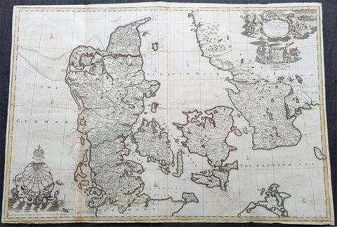
1720 John Senex Large Antique Map of Denmark & Southern Sweden
Antique Map
- Title : Denmark Corrected from the Newest Observations of the Royal Society at London and Paris by John Senex FRS
- Size: 38 1/2in x 27in (965mm x 685mm)
- Condition: (A) Very Good Condition
- Date : 1720
- Ref #: 70706
Description:
This large hand coloured original antique map of Denmark was engraved by John Senex and was published in the 1720 edition of his Elephant Folio Atlas.
This map is in VG condition. These large scale maps are scarce due mainly to their size, with damage and loss over time inevitable.
General Definitions:
Paper thickness and quality: - Heavy and stable
Paper color : - off white
Age of map color: - Original
Colors used: - Yellow, green, blue, pink
General color appearance: - Authentic
Paper size: - 38 1/2in x 27in (965mm x 685mm)
Plate size: - 38in x 26 1/2in (960mm x 680mm)
Margins: - Min 1/4in (6mm)
Imperfections:
Margins: - Chipping to bottom margin
Plate area: - Light offsetting
Verso: - Light creasing
Background:
Before the fifteenth century the people of Southern Europe had little geographical knowledge of the Scandinavian World except from sketchy detail shown in the Catalan Atlas (1375) and on a number of \" portolani\" embracing Denmark and the southern tip of Norway. It was not until 1427 that a manuscript map prepared about that time by Claudius Clavus (b.1388) a Dane who spent some time in Rome, made available to scholars a tolerable outline of the northern countries and Greenland. That was to remain the best map available for the rest of the century and it was used as the basis for maps of Scandinavia in early printed editions of Ptolemy. Others by Nicolaus Cusanus (1491) and Ehrhard Etzlaub (c. 1492) followed but, needless to say, these are extremely rare; even the later maps by Olaus Magnus and Marcus Jordan, where they have survived at all , are known only by a very few examples. In fact, apart from the rare appearance of an early Ptolemy map, the oldest of Scandinavia which a collector is likely to find are those of Munster\'s Cosmograhy first published in 1544. In the following centuries the few maps and charts complied in Scandinavia were usually published in Amsterdam, Antwerp, Paris or Nuremberg, the most important maps often being incorporated in the major Dutch, French & German Atlases. (Ref: Tooley; M&B)
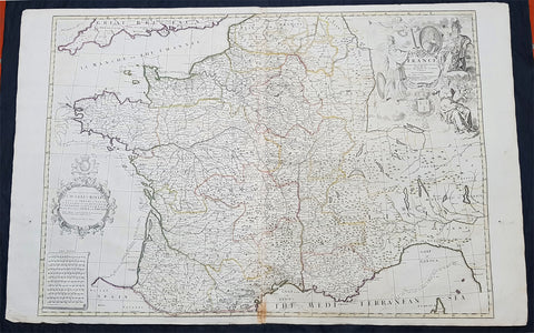
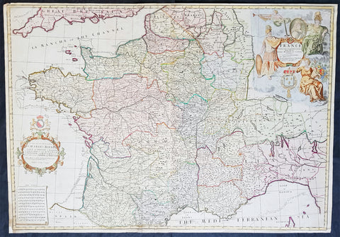
1720 John Senex Large Antique Map of France in Provinces
Antique Map
- Title : France corrected from ye Observations by the Royal Academy Society at Paris by John Senex
- Size: 41 1/2in x 26 1/2in (1.040m x 660mm)
- Condition: (A) Very Good Condition
- Date : 1878
- Ref #: 24903
Description:
This large hand coloured original copper plate engraved antique map of France by John Senex, was published in the 1720 edition of his Elephant Folio Atlas.
This map is in VG condition. These large scale maps are scarce due mainly to their size, with damage and loss over time inevitable.
General Definitions:
Paper thickness and quality: - Heavy and stable
Paper color : - off white
Age of map color: - Original
Colors used: - Yellow, green, blue, pink
General color appearance: - Authentic
Paper size: - 41 1/2in x 26 1/2in (1.040m x 660mm)
Plate size: - 36in x 24 1/2in (915mm x 615mm)
Margins: - Min 1/2in (12mm)
Imperfections:
Margins: - Light chipping to margin edges
Plate area: - Discouloration to bottom centerfold
Verso: - None
Background:
The history of French cartography can be traced to developments in the Middle Ages. This period was marked by improvements in measuring instruments and also by an upgrade of work in registers of all types.
The first map of France was drawn by Oronce Finé and printed in woodcuts in 1525. It testifies to the will of the political power to mark its presence on the territory; to affirm, to build limits, borders, to arrange its territory, and to consolidate the internal economic markets.
In the sixteenth century, Dieppe appeared as an important school of cartography. Pierre Desceliers allowed the realization of many maps. At the same time, the Portolan maps of the Portuguese sailors had the most recent knowledge obtained by the Dieppois sailors in their exploration of Canada.
Then, cartography progressed more and more, through the development of new techniques and by the will of the political powers to control their territories. Very powerful companies testify support to some of the cartographic missions at the end of the nineteenth century.
There were two decisive stages in cartography. One was determining longitude and latitude. Florence Trystram, 2001, the lawsuit of the stars is an account of the research of three French scientists that was done in South America, 1735-1771.
1720 John Senex Large Antique Pre Revolutionary Map of France in Provinces
- Title : France Corrected from ye Observations made by the Royal Academy of Sciences at Paris by John Senex
- Size: 37in x 26in (940m x 660mm)
- Condition: (A) Very Good Condition
- Date : 1720
- Ref #: 81078
Description:
This large beautifully hand coloured original antique map of France was engraved for John Senex for publication in his Elephant Folio Atlas 1720.
These large scale maps are scarce due mainly to their size. Damage and loss over time is inevitable.
General Definitions:
Paper thickness and quality: - Heavy and stable
Paper color : - off white
Age of map color: - Original & later
Colors used: - Yellow, green, blue, pink
General color appearance: - Authentic
Paper size: - 37in x 26in (940m x 660mm)
Plate size: - 36 1/2in x 25 1/2in (930m x 650mm)
Margins: - Min 1/4in (8mm)
Imperfections:
Margins: - Bottom left corner extended from plate-mark
Plate area: - Folds as issued
Verso: - None
Background:
The history of French cartography can be traced to developments in the Middle Ages. This period was marked by improvements in measuring instruments and also by an upgrade of work in registers of all types.
The first map of France was drawn by Oronce Finé and printed in woodcuts in 1525. It testifies to the will of the political power to mark its presence on the territory; to affirm, to build limits, borders, to arrange its territory, and to consolidate the internal economic markets.
In the sixteenth century, Dieppe appeared as an important school of cartography. Pierre Desceliers allowed the realization of many maps. At the same time, the Portolan maps of the Portuguese sailors had the most recent knowledge obtained by the Dieppois sailors in their exploration of Canada.
Then, cartography progressed more and more, through the development of new techniques and by the will of the political powers to control their territories. Very powerful companies testify support to some of the cartographic missions at the end of the nineteenth century.
There were two decisive stages in cartography. One was determining longitude and latitude. Florence Trystram, 2001, the lawsuit of the stars is an account of the research of three French scientists that was done in South America, 1735-1771.