
John Cary (1754-1835)
Profile :
Many regard John Cary as one of the finest English cartographers of his time. His maps are not decorative in the 17th century sense but he came to on the scene at a time when the large-scale English county maps had recently become available. His fine craftsmanship and ability as an engraver enabled him to produce not only fine English county maps but also world atlases, road maps, town and canal plans sea charts and terrestrial and celestial globes
John Cary (1)
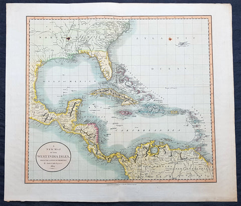
1803 John Cary Large Antique Map North America, United States, Mexico, Caribbean
- Title : A New Map of The West India Isles from the latest Authorities by John Cary Engraver 1803....Published by J Cary Engraver & Mapseller No. 181 Strand Aug 1st 1803
- Ref #: 70578
- Size: 24 1/2in x 21 1/2in (620mm x 550mm)
- Date : 1803
- Condition: (A+) Fine Condition
Description:
This large beautifully hand coloured original copper-plate engraved antique map of North America, The United States, Cenis (Texas) the Gulf of Mexico, The Caribbean, Central America and northern South America was engraved & published by John Cary in 1803 - the date is engraved in the title cartouche - and was published in the 1808 edition of Carys New Universal Atlas. (Ref Tooley M&B)
General Definitions:
Paper thickness and quality: - Heavy and stable
Paper color : - off white
Age of map color: - Original
Colors used: - Yellow, green, blue, pink
General color appearance: - Authentic
Paper size: - 24 1/2in x 21 1/2in (620mm x 550mm)
Plate size: - 21 1/2in x 19 1/2in (535mm x 495mm)
Margins: - Min 1/2in (12mm)
Imperfections:
Margins: - None
Plate area: - Two small spots on the L&R sides of image
Verso: - None
Background:
At the time of the engraving of this map the United States was still very much in its infancy. Thomas Jefferson was the president and the 7th congress sat from March the 4th. Belwo are the following significant events of 1803, in the US.
- January 30 – Monroe and Livingston sail for Paris to discuss, and possibly buy, New Orleans; they end completing the Louisiana Purchase.
- February 24 – Marbury v. Madison: The Supreme Court of the United States establishes the principle of judicial review.
- March 1 – Ohio is admitted as the 17th U.S. state, retroactive from
August 7, 1953
- April 30 – Louisiana Purchase is made by the United States from France.
- July 4 – The Louisiana Purchase is announced to the American people.
- October 20 – The Senate ratifies the Louisiana Purchase Treaty, doubling the size of the United States.
- November 30 – At the Cabildo building in New Orleans, Spanish representatives Governor Manuel de Salcedo and the Marqués de Casa Calvo, officially transfer Louisiana (New Spain) to French representative Prefect Pierre Clément de Laussat. Barely three weeks later, on December 20, France transfers the same land to the United States as the Louisiana Purchase.
1803 saw the birth of Ralph Waldo Emmerson (d 1882) and 1803 saw the death of Samuel Adams & Francis Lewis both signatories of the Declaration of Independence.