
John Cary (1754-1835)
Profile :
Many regard John Cary as one of the finest English cartographers of his time. His maps are not decorative in the 17th century sense but he came to on the scene at a time when the large-scale English county maps had recently become available. His fine craftsmanship and ability as an engraver enabled him to produce not only fine English county maps but also world atlases, road maps, town and canal plans sea charts and terrestrial and celestial globes
John Cary (2)
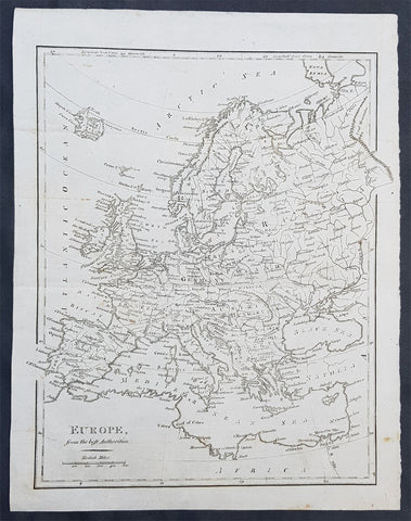
1797 John Cary Original Antique Map of Europe
- Title : Europe from the Best Authorities
- Size: 12 1/2in x 10in (315mm x 255mm)
- Ref #: 92766
- Date : 1797
- Condition: (A+) Fine Condition
General Definitions:
Paper thickness and quality: - Heavy and stable
Paper color : - off white
Age of map color: -
Colors used: -
General color appearance: -
Paper size: - 12 1/2in x 10in (315mm x 255mm)
Plate size: - 12 1/2in x 10in (315mm x 255mm)
Margins: - Min 1/2in (12mm)
Imperfections:
Margins: - None
Plate area: - Folds as issued
Verso: - None
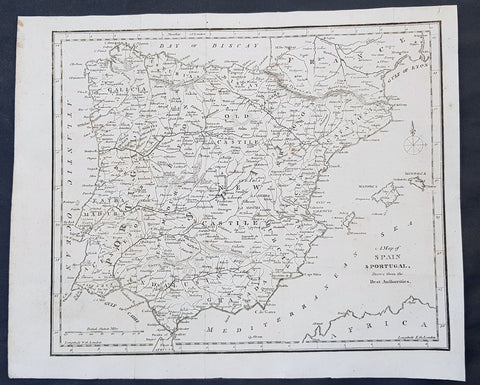
1797 John Cary Original Antique Map of Spain, Portugal & The Balearic Islands
- Title : A Map of Spain & Portugal Drawn from the Best Authorities
- Size: 12in x 10in (305mm x 255mm)
- Ref #: 92755
- Date : 1797
- Condition: (A+) Fine Condition
Description:
This fine original copper-plate engraved antique map by John Cary was published in the 1797 edition of Moores Geography
General Definitions:
Paper thickness and quality: - Heavy and stable
Paper color : - off white
Age of map color: -
Colors used: -
General color appearance: -
Paper size: - 12in x 10in (305mm x 255mm)
Plate size: - 12in x 10in (305mm x 255mm)
Margins: - Min 1/2in (12mm)
Imperfections:
Margins: - None
Plate area: - Folds as issued
Verso: - None