
Johannes Jansson (1588 - 1664)
Profile :
Johannes Janssonius, more commonly known to us as Jan Jansson, was born in Arnhem where his father was a bookseller and publisher (Jan Janszoon the Elder).
In 1612 he married the daughter of the cartographer and publisher Jodocus Hondius, and then set up in business in Amsterdam as a book publisher. In 1616 he published his first maps of France and Italy and from then onwards he produced a very large number of maps, perhaps not quite rivaling those of the Blaeu family but running a very close second in quantity and quality.
From about 1630 to 1638 he was in partnership with his brother-in-law, Henricus Hondius, issuing further editions of the Mercator/Hondius atlases to which his name was added. On the death of Henricus he took over the business, expanding the atlas still further, until eventually he published an 11-volume Atlas Major on a scale similar to Blaeu's Atlas Major.
The first full edition of Jansson's English County Maps was published in 1646 but some years earlier he issued a number of British maps in the Mercator/Hondius/Jansson series of atlases (1636-44); the maps were printed from newly engraved plates and are different from the later 1646 issue and are now rarely seen (see Appendix B for further details). In general appearance Jansson's maps are very similar to those of Blaeu and, in fact, were often copied from them, but they tend to be more flamboyant and decorative.
After Jansson's death his heirs published a number of maps in an Atlas Contractus in 1666, later still many of the plates of his British maps were acquired by Pieter Schenk and Gerard Valck who published them again in 1683 as separate maps
Jan Jansson (1)
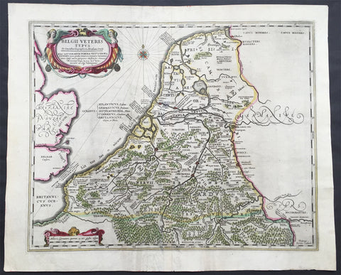
1638 Jansson Large Antique Map of The Netherlands & Belgium
- Title : Belgii Veteris Typus...Abrahami Ortelii...Petrus Karius
- Ref #: 61036
- Size: 21 1/2in x 17 1/2in (545mm x 445mm)
- Date : 1638
- Condition: (A) Very Good Condition
Description:
This large beautifully hand coloured original antique map of The Netherlands & Belgium was engraved by Peter Karius and was published in the 1638 Latin edition of Mercator's Atlas published by Henricus Hondius and Jan Jansson. (Ref: Koeman; M&B; Tooley)
Condition Report:
Paper thickness and quality: - Heavy and stable
Paper color: - off white
Age of map color: - Original
Colors used: - Yellow, pink, green
General color appearance: - Authentic
Paper size: - 21 1/2in x 17 1/2in (545mm x 445mm)
Plate size: - 19in x 15 1/2in (480mm x 395mm)
Margins: - Min 1in (25mm)
Imperfections:
Margins: - Light creasing in bottom margin
Plate area: - Centerfold Re-joined
Verso: - Soiling