
Johann Baptist Homann (1663 – 1724)
Profile :
Following the long period of Dutch domination in the field of Cartography, the Homann family became the most important map publishers in Germany in the eighteenth century. The business being founded by J.B. Homann in Nuremberg about the year 1702.
Soon after publishing his first atlas in 1707 he became a member of the Berlin academy of Sciences and in 1715 he was appointed Geographer to the Emperor. After the founder’s death in 1724, the firm was continued under the direction of his son until 1730 and was then bequeathed to his heirs on the condition that it trades under the name of Homann Heirs. The firm remained in being until the next century and had a wide influence on map publishing in Germany. Apart from the atlases the firm published a very large number of individual maps.
The Homman’s produced a Neuer Atlas in 1714, a Grosser Atlas in 1737, and an Atlas Maior with about 300 maps in 1780. They also issued a special Atlas of Germany with full sized plans of principal cities, school atlases and an Atlas of Silesia in 1750 with 20 maps.
Johann Baptist Homann (16)
1707 Homann Rare Ist Edition Twin Hemisphere World Antique Map, California Isle.
Antique Map
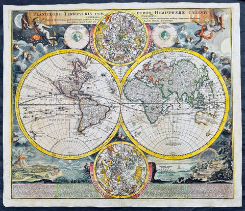
- Title : Planiglobii Terrestris Cum Utroq. Hemisphaerio Caelesti Generalis Exhibitio.
- Date : 1707
- Size: 23 1/2in x 20 1/2in (600mm x 520mm)
- Condition: (A) Very Good Condition
- Ref: 61006
Description:
This large beautifully hand coloured original scarce first edition copper plate engraved antique twin hemisphere world map by Johann Baptist Homann was engraved in 1707 and published in Homanns 1710 edition of Neuer Atlas.
Later editions of the map is commonly misidentified as first editions. In later editions the words Cum Priviligo (Imperial privilege or permission) are engraved in the title, this privilege was later awarded to the Homanns and included in all future maps. In later editions California is shown as a peninsular and not an Island as shown in this map.
General Definitions:
Paper thickness and quality: - Heavy and stable
Paper color : - off white
Age of map color: - Original & later
Colors used: - Yellow, green, blue, pink
General color appearance: - Authentic
Paper size: - 23 1/2in x 20 1/2in (600mm x 520mm)
Plate size: - 22 1/4in x 19 1/4in (515mm x 490mm)
Margins: - Min 1/2in (12mm)
Imperfections:
Margins: - Light soiling
Plate area: - Professional paper rejoin left margin 2in into image, no loss. Light age toning
Verso: - Light soiling
Background:
The map evokes the Dutch maps of the previous century, featuring an insular California and a depiction of Australia and the South Pacific that resembles that of Abel Tasman. Homann nonetheless incorporated a significant detail from the state-of-the-art maps of the Parisian geographer Guillaume De l'Isle, and the English polymath Edmund Halley. The map is a rich compendium of explorers' routes, including Magellan, Tasman, Gaetani, and Chaumont, as well as the extremely current voyages of Dampier (whose discovery of Nova Britannia near New Guinea is shown with a date of 1700). Above and below the cruxes of the main hemispheres are a pair of celestial hemispheres. At the bottom is a beautifully engraved panorama illustrating volcanoes, earthquakes, the tides, marine vortices, rain, and rainbows. These themes are significant in that they are neither mythological nor allegorical: they are plainly discussed natural phenomena. The map, then, is a visual representation of a shift to a more modern, scientific approach to the study of the world that would be typical of the 18th century.
Homann describes his sources as 'the latest and most approved maps of the French and the Dutch'. The bulk of Asia, Africa, and Europe appear to derive from the c. 1700 Peter Schenk Haemisphaeriorum Tabula Carthesiana, while the labeling scheme shows a strong similarity to the c. 1700 Danckerts De Werelt Caart. The primary French source is certainly Guillaume de l'Isle's 1700 Mappe-Monde. The explorers' tracks, the illustration of the Sargasso Sea, and an astonishing (and erroneous) sighting of Antarctica all derive from De l'Isle. Likewise with the treatment of the Pacific Northwest coast and Asiatic northeast, including the channel separating Terra Iesso from the mainland. Otherwise, the general models of Asia, Africa, and South America closely follow the c. 1700 Schenk.
The mapping of North America, here, is very different from either the Schenk or the 1700 De l'Isle. Although Homann retained California as an Island, the map was quite up to date. It presents a largely correct delineation of the Great Lakes and the Mississippi. The northwest part of Canada and the course of the Mississippi reveal the likely source: De l'Isle's 1703 Carte du Canada ou de la Nouvelle France (including the Baron Lahontan's spurious geography) and De l'Isle's Carte du Mexique et de la Floride. (Ref: Tooley; M&B)
Please note all items auctioned are genuine, we do not sell reproductions. A Certificate of Authenticity (COA) can be issued on request.
1715 J B Homann Large Antique Map of North America Virginia Chesapeake Bay NJ, NY
Antique Map
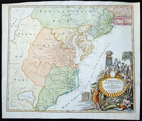
- Title : Virginia Marylandia et Carolina in America Septentrionali Britannorum industria excultae"...Homann
- Date : 1715
- Condition: (A+) Fine Condition
- Ref: 82002
- Size: 24 1/2in x 21 1/4in (625mm x 540mm)
Description:
This large finely engraved beautifully hand coloured original antique map of Virginia, Chesapeake Bay, Maryland, the Carolina's, New Jersey, Pennsylvania, Maryland, New York and parts west of the Apalchians, was published by J.B Homann in 1715.
An exceptionally beautiful example of J. B. Homann's 1715 map of Virginia, Carolina, Maryland, and New Jersey; considered one of the most important and decorative maps of is region to appear in the 18th century. This fine decorative map covers from New York City and Long Island south along the Atlantic Cost as far as modern day Georgia, and as far west as Lake Erie.
General Description:
Paper thickness and quality: - Heavy and stable
Paper color: - off white
Age of map color: - Original & later
Colors used: - Yellow, green, blue, pink
General color appearance: - Authentic
Paper size: - 24 1/2in x 21 1/4in (625mm x 540mm)
Plate size: - 23in x 19 1/2in (580mm x 490mm)
Margins: - Min 1/2in (12mm)
Imperfections:
Margins: - None
Plate area: - None
Verso: - None
Background:
Homann drew this map in response to Virginia Lieutenant-Governor Alexander Spotswood's plan to settled the little known interior of Virginia with German immigrants. Shown here is the first mapping of Germantown Teutsche Statt on the Rappahanock River and Fort Christanna (Christ Anna Fort) on the Makharing River. Fort Christanna was built with the intention of defending the region against incursions from hostile American Indian groups such as the Tuscarora to the west. Christanna also acted as the headquarters of the Virginia Indian Company, a stock venture founded in 1714 with the intention of trading with indigenous groups in the interior.Though Homann's remarkable representation of Spottswood's plan is extraordinarily up-to-date considering that Fort Christana was founded in the same year that this map was initially published, the remainder of the map embraces a number of common misconceptions and cartographic inaccuracies common to the region. Probably the most notable of these is his inclusion of Apalache Lacus. This fictional lake, the source of the May River, appeared on maps of this region since the mid 16th century Le Moyne-De Bry map and was popularized by Mercator and Hondius in 1606.
It would remain on maps well into the mid 18th century before exploration and settlement finally disproved the theory. Further north Lake Erie and been expanded dramatically and shifted somewhat to the south where it takes on the appearance of a vast inland sea occupying the entire northwestern quadrant of the map. This region, west of the English colonies and north as far as Pennsylvana, Homann attaches to the Spanish claims in Florida.
Homann's also offers a wealth of detail along the Atlantic coast, where most of the European colonization efforts were focused. From Long Island, about two-thirds of which is shown, south to Craven County, Carolina, countless towns and cities are identified. New York City is mapped on the southern tip of Manhattan Island, but is not specifically labeled. New Jersey is divided into the colonial provinces of East New Jersey and West New Jersey. Curiously Homann maps a large inland lake "Zuyd Lac" straddling the New Jersey - Pennsylvania border. This is no doubt a early misinterpretation of the natural widening of the Delaware River at the Delaware Water Gap. Heading south along the Delaware River Philadelphia is identified and beautifully rendered as a grid embraced in four quadrants. Both the Delaware Bay and the Chesapeake Bay are rendered in full and even include a number of undersea notations and depth soundings. In Virginia and Carolina the river systems are surprisingly well mapped and a primitive county structure is beginning to emerge.
The early Virginia counties of Rappahannock, Henrico, City, Isle of Wright, Nansemond, Northumberland, Middlesex, Gloster and Corotvk are noted. Similarly in Carolina a number of counties are named, most of which refer to the Lords Proprietors, including Albemarle, Clarenden, and Craven. Cape Fear, Cape Lookout, and Cape Hattaras are noted and a number of anchorages, reefs, and depth sounding are noted along the entire coastline. The lower right quadrant of this map is occupied by a fabulous decorative title cartouche. Centered on an enormous scallop shell bearing the map's title and Homann's Privilege, the cartouche features a number of stylized American Indians trading with European merchants.
The wealth of the region is expressed by an abundance of fish, game, and other trade products. Curling behind the scallop shell is a gigantic stylized alligator looking like nothing so much as a mediaeval dragon. The inclusion of Homann's Provildge in the title cartouche helps us to date this map to about 1715, when Homann was granted the right to add this royal distinction to his maps. (Ref: Tooley; M&B)
1720 Homann Large Antique Map of The Islands of Malta - Gozo, Comino, Valletta
Antique Map
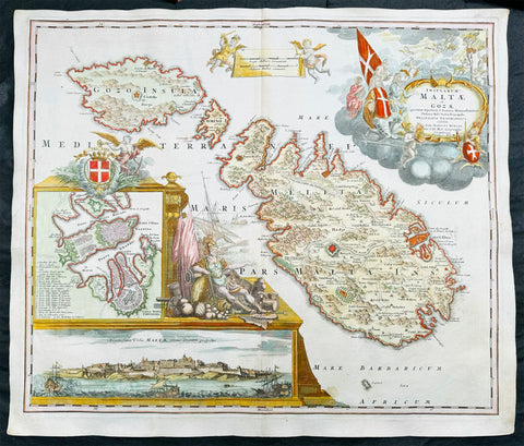
- Title : Insularum Maltae et Gozae quae sunt Equitum S. Ioannis Hierosolimitani Ordinis Melit. Sed
- Date : 1720
- Size: 24in x 20 1/2in (610mm x 520mm)
- Condition: (A+) Fine Condition
- Ref: 43169
Description:
This large beautifully hand coloured original copper plate engraved antique map of the Mediterranean Islands of Malta, Gozo and Comino by J B Homann was published in 1720.
This is one of the best examples of this map I have seen to date. The paper is heavy and clean, original colouring is fresh and beautifully applied with original margins.
General Definitions:
Paper thickness and quality: - Heavy and stable
Paper color : - off white
Age of map color: - Original
Colors used: - Yellow, green, blue, pink
General color appearance: - Authentic
Paper size: - 24in x 20 1/2in (610mm x 520mm)
Plate size: - 23in x 19 1/2in (590mm x 500mm)
Margins: - Min 1/2in (12mm)
Imperfections:
Margins: - None
Plate area: - None
Verso: - None
Background:
One of the most superbly embellished and desirable maps of Malta. Homann's magnificent map of Malta, includes detailed topographical information and many place names. The elaborate title cartouche depicts the knights of Malta in prayer before an image of the crucified Christ. At lower left is a panorama of Valetta from the sea and a further inset map of Valletta with a key of buildings and sites. To the right of the insets is a second elaborate embellishment comprising the Maltese coat of arms and the figure of a Knight of Malta Collections (Ref: Tooley; M&B)
Please note all items auctioned are genuine, we do not sell reproductions. A Certificate of Authenticity (COA) can be issued on request.
1720 Homann Large Old, Antique Map of North America, Louisiana, Mississippi, Buffalo Map
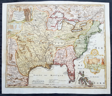
- Title : Amplissimae Regionis Mississipi seu Provinciae Ludovicianae a R.P. Ludovico Hennepin Francisc....
- Date : 1720
- Condition: (A+) Fine Condition
- Ref: 43168
- Size: 25in x 21 1/4in (635mm x 540mm)
Description:
This large finely engraved beautifully hand coloured original antique map of North America from the United States, the Mississippi River, to Spanish North America was published by J.B Homann in 1720
General Description:
Paper thickness and quality: - Heavy and stable
Paper color: - off white
Age of map color: - Original & later
Colors used: - Yellow, green, blue, pink
General color appearance: - Authentic
Paper size: - 25in x 21 1/4in (635mm x 540mm)
Plate size: - 23in x 19 1/2in (590mm x 500mm)
Margins: - Min 1/2in (12mm)
Imperfections:
Margins: - Light age toning in top margin
Plate area: - None
Verso: - None
Background:
This iconic map of Louisiana, the Mississippi River Valley to the Colonial United States by Johann Baptiste Homann, is commonly called the 'Buffalo Map' for its distinctive decorative elements depicting a stylized buffalo. This map is derived from an earlier 1718 map of the same region by G. De L'Isle though it has been enlarged to include New England.
The map covers much of the modern day United States from Canada and the Great Lakes to the Florida Keys and from Mexico and Texas to the Pacific. According to the political conventions of the time this map is segmented into various zones including New Mexico (red) along the Rio de Norte (Rio Grande), Louisiana (blue) covering a vast area including Texas, all five of the Great Lakes, and both the upper and lower Mississippi River Valleys, Florida (green) consisting most of the American southeast, the english Colonies (yellow) along the Atlantic seaboard, and Canada (red) stretching across the top of the map north of the Great Lakes. Various explorers' routes (including de Soto) are noted, as are mission settlements, American Indian villages, fortifications, and portages. Florida is depicted as an archipelago inhabited by anthropophagi (cannibals). The cartouche work, in the upper left quadrant, details Niagara Falls as well as various allegorical illustrations. A secondary cartouche, showing American Indians and a stylized buffalo appears in the lower right.
This map enjoyed a long production run and was extremely popular throughout europe – most likely for its decorative inclusion of the American Buffalo and Niagara Falls, objects of fascination for many 18th century europeans. Though this map was issued in only one edition, it was published in Homann's Neuer Atlas, the Atlas Major, and many other composite atlases well into the late 1700s, making specific instances of the map all but possible to date with precision. Most examples thus reference the original publication date, c. 1720. (Ref: Tooley; M&B)
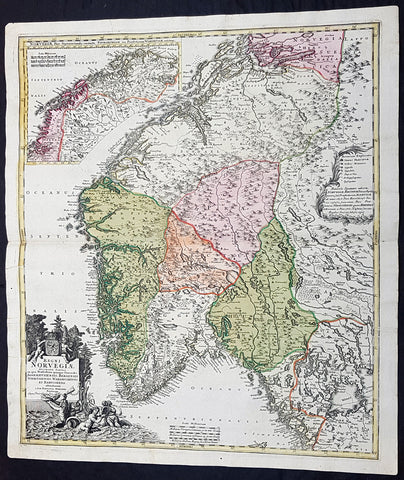
1720 J B Homann Large Original Antique Map of Norway - Regni Norvegiae
Antique Map
- Title : Regni Norvegiae Accurata Tabula in qua Praefecturae Quinque Generales Aggerhusiensis, Bergensis Nidrosiensis, Wardhusiensis et Bahusiensi Ioh. Bapt. Homanno.
- Date : 1720
- Condition: (A+) Fine Condition
- Ref: 93359
- Size: 24in x 20 1/4in (610mm x 540mm)
Description: This large beautifully hand coloured original antique map of Norway & parts of Scandinavia - with an inset map of Lapland & Northern Norway - was published by Johann Baptist Homann in 1720.
Condition Report:
Paper thickness and quality: - Heavy and stable
Paper color: - Off white
Age of map color: - Original
Colors used: - Yellow, pink, green
General color appearance: - Authentic
Paper size: - 24in x 20 1/4in (610mm x 540mm)
Plate size: - 23 1/2in x 20in (595mm x 505mm)
Margins: - Min 1/2in (12mm)
Imperfections:
Margins: - None
Plate area: - None
Verso: - None
Background: Before the fifteenth century the peoples of Southern Europe had little geographical knowledge of the Scandinavian world except from sketchy detail shown in the Catalan Atlas (1375) and on a number of 'portolani' embracing Denmark and the southern tip of Norway. It was not until 1427 that a manuscript map prepared about that time by Claudius Clavus (b. 1388), a Dane who had spent some time in Rome, made available to scholars a tolerable outline of the northern countries and Greenland. That was to remain the best map available for the rest of the century and it was used as the basis for maps of Scandinavia in early printed editions of Ptolemy. Others by Nicolaus Cusanus (1491) and Ehrhard Etzlaub (c. 1492) followed but, needless to say, these are extremely rare; even the later maps by Olaus Magnus and Marcus Jordan, where they have survived at all, are known only by very few examples. In fact, apart from the rare appearance of an early Ptolemy map, the oldest of Scandinavia which a collector is likely to find are those in Munster's Cosmography published in 1544 with many later editions. In the following centuries the comparatively few maps and charts compiled in Scandinavia were usually published in Amsterdam, Antwerp, Paris or Nuremberg, the more important maps often being incorporated in the major Dutch, French and German atlases. (Ref: Tooley; M&B)
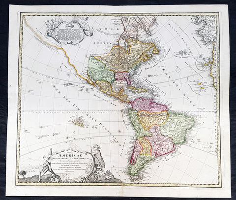
1720 Johannes Baptist Homann Large Antique Map of America
Antique Map
- Title : Totius Americae Septentrionalis et Meridionalis Novissima Representatio quam ex fingulis Geographorum Tabulis collecta luci publicae accommodavit...Johannes Baptista Homann
- Ref #: 93506
- Size: 24in x 21in (610mm x 525mm)
- Date : 1720
- Condition: (A+) Fine Condition
Description:
This large original beautifully hand coloured copper plate antique map of America was published by Johann Baptist Homann in 1720.
A very nice example of this early landmark American map by one of the greats of 17th & 18th century German cartography.
General Definitions:
Paper thickness and quality: - Heavy and stable
Paper color : - off white
Age of map color: - Original
Colors used: - Blue, pink, red, green, yellow
General color appearance: - Authentic
Paper size: - 24in x 21in (610mm x 525mm)
Plate size: - 22 1/2in x 19in (565mm x 490mm)
Margins: - Min 1in (25mm)
Imperfections:
Margins: - None
Plate area: - None
Verso: - Bottom centerfold rejoined at bottom of map, not affecting the image
Background:
This is the second state of Homanns map of America that includes an elongated northwest Coastline is called Costa Terrae Borealis incognitae detecta a Dom: Ioanne de Gama navigante ex China in Novam Hispaniam. The map provides credit for the discovery of this coastline to João de Gama (1540-1591). João da Gama, the grandson of Vasco da Gama, was a Portuguese explorer and colonial administrator in the Far East, during the last quarter of the 16th century. Da Gama sailed from Macau to the northeast and rounded Japan by north, crossing the Pacific Ocean at the northernmost latitudes. The lands northeast of Japan, which João da Gama discovered, were the subject of legend and speculation in the centuries that followed, inspiring its search by European powers.
Good detail throughout the map, especially in the southwest and near the Great Lakes, which were then actively being explored by the French fur traders and Hudson\'s Bay Company.

1735 Homann Large Antique Map of Oran, Algeria, North Africa
- Title : Topographica Repræsentatio Barbarici Portus et Urbis Munitæ Oran... Nuremberg, 1732
- Ref #: 43187
- Size: 24 1/2in x 21 1/4in (620mm x 540mm)
- Date : 1735
- Condition: (A+) Fine Condition
Description:
This large fine beautifully hand coloured original antique map and view of the City of Oran & Environs in the North African country of Algeria, as it was being captured by the Spanish in 1732, was published by Homann Heirs in ca 1735.
Background: Chart of the environs of Oran in Algeria, with a panorama of the city and environs, decorated with several sailing battle ships. In 1509 Spain captured Oran from the Moors, but in 1708, with Spain disadvantaged by the War of the Spanish Succession, they were driven out by the Turkish Bey, Mustapha Ben Youssef. In 1732 José Carrillo de Albornoz, 1st Duke of Montemar (1671-1747), recaptured Oran, causing this map to be published, after which the Spanish held the city until 1792. When the Spanish saw no point in keeping it, when it was handed over to the Bey of Algiers(Ref: Tooley; M&B)
General Description:
Paper thickness and quality: - Heavy and stable
Paper color: - off white
Age of map color: - Original
Colors used: - Yellow, green, blue, pink
General color appearance: - Authentic
Paper size: - 24 1/2in x 21 1/4in (620mm x 540mm)
Plate size: - 22 1/2in x 19 1/2in (570mm x 500mm)
Margins: - Min 1/2in (12mm)
Imperfections:
Margins: - None
Plate area: - None
Verso: - None
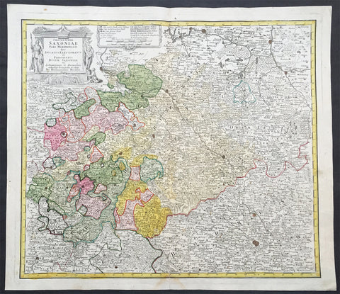
1735 J B Homann Large Antique Map of Old Saxony, Germany - Berlin to Prague
- Title : Circuli Super Saxoniae pars Meridionalis sive Ducatus...Homannianos
- Date : 1735
- Condition: (A+) Fine Condition
- Ref # : 30832
- Size : 23in x 19in (600mm x 520mm)
Description:
This large original hand coloured copper plate engraved antique map of the Saxony region of central Germany. The map stretches from Berlin in the north to Prague in the Czech Republic to the south, by J B Homann was published by the Homann Heirs firm in 1735. (Ref: Tooley; M&B)
General Definitions:
Paper thickness and quality: - Heavy and stable
Paper color : - off white
Age of map color: - Original
Colors used: - Blue, pink, red, green, yellow
General color appearance: - Authentic
Paper size: - 23in x 19in (600mm x 520mm)
Plate size: - 24in x 19 1/2in (565mm x 495mm)
Margins: - Min 1in (25mm)
Imperfections:
Margins: - None
Plate area: - None
Verso: - None
Background:
Saxony is a landlocked federal state of Germany, bordering the federal states of Brandenburg, Saxony Anhalt, Thuringia, and Bavaria, as well as the countries of Poland and the Czech Republic.
The history of the state of Saxony spans more than a millennium. It has been a medieval duchy, an electorate of the Holy Roman Empire, a kingdom, and twice a republic.
The area of the modern state of Saxony should not be confused with Old Saxony, the area inhabited by Saxons. Old Saxony corresponds roughly to the modern German states of Lower Saxony, Saxony-Anhalt, and the Westphalian part of North Rhine-Westphalia.
The territory of the Free State of Saxony became part of the Holy Roman Empire by the 10th century, when the dukes of Saxony were also kings (or emperors) of the Holy Roman Empire, comprising the Ottonian, or Saxon, Dynasty. Around this time, the Billungs, a Saxon noble family, received extensive fields in Saxony. The emperor eventually gave them the title of dukes of Saxony. After Duke Magnus died in 1106, causing the extinction of the male line of Billungs, oversight of the duchy was given to Lothar of Supplinburg, who also became emperor for a short time.
In 1137, control of Saxony passed to the Guelph dynasty, descendants of Wulfhild Billung, eldest daughter of the last Billung duke, and the daughter of Lothar of Supplinburg. In 1180 large portions west of the Weser were ceded to the Bishops of Cologne, while some central parts between the Weser and the Elbe remained with the Guelphs, becoming later the Duchy of Brunswick-Lüneburg. The remaining eastern lands, together with the title of Duke of Saxony, passed to an Ascanian dynasty (descended from Eilika Billung, Wulfhild\\\\\\\'s younger sister) and were divided in 1260 into the two small states of Saxe-Lauenburg and Saxe-Wittenberg. The former state was also named Lower Saxony, the latter Upper Saxony, thence the later names of the two Imperial Circles Saxe-Lauenburg and Saxe-Wittenberg. Both claimed the Saxon electoral privilege for themselves, but the Golden Bull of 1356 accepted only Wittenberg\\\\\\\'s claim, with Lauenburg nevertheless continuing to maintain its claim. In 1422, when the Saxon electoral line of the Ascanians became extinct, the Ascanian Eric V of Saxe-Lauenburg tried to reunite the Saxon duchies.
However, Sigismund, King of the Romans, had already granted Margrave Frederick IV the Warlike of Meissen (House of Wettin) an expectancy of the Saxon electorate in order to remunerate his military support. On 1 August 1425 Sigismund enfeoffed the Wettinian Frederick as Prince-Elector of Saxony, despite the protests of Eric V. Thus the Saxon territories remained permanently separated. The Electorate of Saxony was then merged with the much bigger Wettinian Margraviate of Meissen, however using the higher-ranking name Electorate of Saxony and even the Ascanian coat-of-arms for the entire monarchy. Thus Saxony came to include Dresden and Meissen. In the 18th and 19th centuries Saxe-Lauenburg was colloquially called the Duchy of Lauenburg, which in 1876 merged with Prussia as the Duchy of Lauenburg district.
Saxony-Wittenberg, in modern Saxony-Anhalt, became subject to the margravate of Meissen, ruled by the Wettin dynasty in 1423. This established a new and powerful state, occupying large portions of the present Free State of Saxony, Thuringia, Saxony-Anhalt and Bavaria (Coburg and its environs). Although the centre of this state was far to the southeast of the former Saxony, it came to be referred to as Upper Saxony and then simply Saxony, while the former Saxon territories were now known as Lower Saxony.
In 1485, Saxony was split. A collateral line of the Wettin princes received what later became Thuringia and founded several small states there (see Ernestine duchies). The remaining Saxon state became still more powerful and was known in the 18th century for its cultural achievements, although it was politically weaker than Prussia and Austria, states which oppressed Saxony from the north and south, respectively.
Between 1697 and 1763, the Electors of Saxony were also elected Kings of Poland in personal union.
In 1756, Saxony joined a coalition of Austria, France and Russia against Prussia. Frederick II of Prussia chose to attack preemptively and invaded Saxony in August 1756, precipitating the Third Silesian War (part of the Seven Years\\\\\\\' War). The Prussians quickly defeated Saxony and incorporated the Saxon army into the Prussian army. At the end of the Seven Years\\\\\\\' War, Saxony recovered its independence in the 1763 Treaty of Hubertusburg.
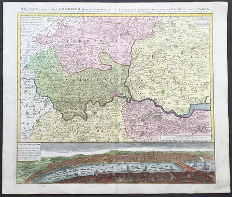
1741 Large Homann Antique Map of London Surrey - Birds Eye View of London
- Title : Regionis quae est circa Londinum....Homaniamus Heredibus 1741
- Date : 1741
- Condition: (A+) Fine Condition
- Ref: 92275
- Size: 25 ½in x 21 ½in (650mm x 550mm)
Description:
This beautifully hand coloured original antique map* of the Environs of London - Middlesex, Essex, Surrey and Kent - with a beautiful and a very real view of the city of London in the mid 18th century and the Thames - was engraved in 1741 - dated at the top of the map - and was published by the Homann firm.
A superb map with a deep heavy impression, stunning colour and sound heavy paper, a fine map.
Background: This map is based upon an earlier map of the region by Thomas Bowles and covers the London area from Berkshire (including Windsor Castle) in the west to Shamel in the east, extending north north as far as Bedford. Specifically focuses on Hertfordshire, Middlesex, Surrey, Essex and Kent. Offers extraordinary detail throughout, showing roadways, villages, London Streets, estates, and in many cases, individual homes. The lower portion of the sheet is dominated by a dramatic bird's-eye view of London and Westminster from Southwark across the Thames. View reveals a densely populated showing numerous boats, barges, and sailing vessels.
The beautifully hand coloured view of the city of London & Westminster was published only 90 odd years after the great fire of 1666.The view of London after Thomas Bowles, was one of a number published by Bowles and the Homann firm in the mid 18th century illustrating the growth and change of the great city.
The view is stunning, stretching from old London bridge & the docklands in the east to the farmlands to the west. What is really fascinating is the level of detail. There are a myriad of different sailing vessels occupying both sides of London bridge. The number of shops and residences that occupied the bridge at that time are uniquely displayed as is the number churches and cathedrals that dominate the skyline. To the right you can see the farm land that will one day become the West End and other upmarket areas of London.(Ref: M&B; Tooley)
General Description:
Paper thickness and quality: - Heavy and stable
Paper color: - off white
Age of map color: - Original & later color
Colors used: - Yellow, green, pink
General color appearance: - Authentic
Paper size: - 25 ½in x 21 ½in (650mm x 550mm)
Plate size: - 22 ½in x 20in (570mm x 510mm)
Margins: - Min ½in (12mm)
Imperfections:
Margins: - Light soiling in margins
Plate area: - None
Verso: - Bottom left plate-mark a little worn
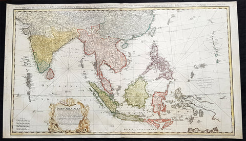
1748 Homann Large Antique Map of Australia, Indonesia, China, SE Asia, India
- Title : Carte Des Indes Orientalis...1748
- Ref #: 93411
- Size: 36 1/4in x 21 1/4in (920mm x 540mm)
- Date : 1748
- Condition: (A+) Fine Condition
Description:
This very large original hand coloured copper plate engraved antique map map of India, SE Asia, The East Indies, Philippines, New Guinea & Australia was engraved by Sebastian Dorn in 1748, dated, and published by the Homann firm.
General Definitions:
Paper thickness and quality: - Light and stable
Paper color : - off white
Age of map color: - Original
Colors used: - Yellow, green, blue, pink
General color appearance: - Authentic
Paper size: - 36 1/4in x 21 1/4in (920mm x 540mm)
Plate size: - 35 1/2in x 20 1/2in (900mm x 515mm)
Margins: - Min 1/2in (12mm)
Imperfections:
Margins: - Light soiling
Plate area: - None
Verso: - Light soiling
Background:
The map is based upon the sea charts created by Jean-Batiste de Mannevillette (1707-80), for the first edition of his Le Neptune Oriental, the first sea atlas of Asian Waters. Mannevillette apprenticed under the great royal cartographer Guillaume De L\'Isle. He then joined the maritime service of the Compagnie des Indes, eventually attaining the rank of captain. Upon his return to Paris, Mannevillette was appointed as director of the Dépôt des Cartes et Plans de la Navigation des Indes.
In 1745, Manneveillette published the first edition of his sea atlas of Asian waters, Le Neptune Oriental. The high quality of Mannevillette\'s charts won him the acclaim of both mariners and academics alike, and he was admitted as a fellow of the Academy of Sciences. He published a second, heavily revised, edition of the Neptune Oriental in 1775.
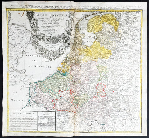
1748 Homann, Mayer Large Old, Antique Map of The Netherlands, Belgium, Holland
- Title : Belgii Universi seu Inferioris Germaniae quam XVII Provinciae Austriaco, Gallico et Batavo sceptro parentes constituunt nova Tabula Geographica a Tobia Majero Math. Cult. ad leges legitimae delineationis revocata Cura et studio Homanniorum Heredum A. 1748
- Ref #: 16422
- Size: 21 1/2in x 20in (545mm x 510mm)
- Date : 1748
- Condition: (A) Very Good Condition
Description:
This large beautifully hand coloured original antique map* of Holland, The Netherlands and Belgium was engraved in 1748 byJohann Tobias Mayer - dated in Title - and was published by Homann firm in 1750.
Background: A beautifully detailed 1748 Homann Heirs map of Belgium and the Netherlands (Holland). Includes Belgium proper as well as the seven states of the Belgian Federation – what is today Holland or the Netherlands. Also includes parts of England and extends into eastern Germany past the Rhine River.
Title elaborate cartouche in the upper left quadrant, filling the North Sea, features the armorial shields of the Belgian Counties as well as those of the seven states of the federation: Geldern, Holland, Zeeland, Utrecht, Friesland, Ober Issel, and Groningen.
This map was drawn by Johann Tobias Mayer for inclusion the 1752 Homann Heirs Maior Atlas Scholasticus ex Triginta Sex Generalibus et Specialibus…. Most early Homann atlases were 'made to order' or compiled of individual maps at the request of the buyer. However, this rare atlas, composed of 37 maps and charts, was issued as a 'suggested collection' of essential Homann Heirs maps. (Ref: Tooley; M&B)
General Description:
Paper thickness and quality: - Heavy and stable
Paper color: - off white
Age of map color: - Original
Colors used: - Yellow, green, blue, pink
General color appearance: - Authentic
Paper size: - 21 1/2in x 20in (545mm x 510mm)
Plate size: - 21in x 19 1/2in (535mm x 495mm)
Margins: - Min 1/2in (12mm)
Imperfections:
Margins: - None
Plate area: - Light creasing along centrefold
Verso: - Re-enforced along centrefold
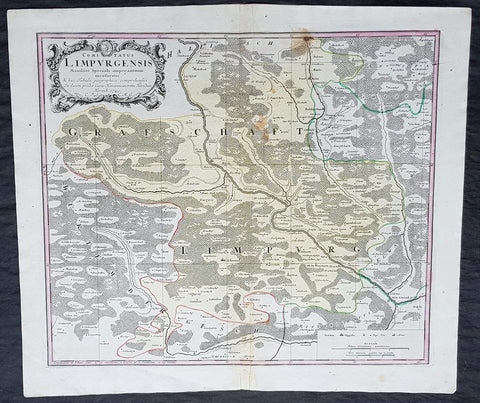
1749 Homann Antique Map Limpurg County, Schwabisch-Hall Baden-Wurtemberg Germany
- Title : Comitatus Limpurgensis Mandato Speciali imperantium mensuratus & hac Tabula geographica comprehensus / In lucem prodit Curis Homannianorum Heredum / Norimb 1749
- Date : 1749
- Condition: (A+) Fine Condition
- Ref: 20428
- Size: 23 1/2in x 20in (595mm x 510mm)
Description:
This large original copper-plate engraved antique map of Limpurg County in the district of Schwäbisch-Hallin in the state of Baden-Wurtemberg, SW Germany by the Homann Heirs was engraved in 1749 - dated in cartouche - and published in the Homanns 1750 German Atlas.
Limpurg is situated in the present-day district of Schwäbisch-Hall or Ostalbkreis between Schwäbisch-Hall, Schwäbisch Gmünd, Aalen and Ellwangen.
The map centers on the river Kocher, with towns marked such as Schwäbisch-Hall (Comburg), Gaildorf, Abstgemünd and Bühlertann.
General Definitions:
Paper thickness and quality: - Heavy and stable
Paper color : - off white
Age of map color: - Original
Colors used: - Yellow, Green, pink
General color appearance: - Authentic
Paper size: - 23 1/2in x 20in (595mm x 510mm)
Plate size: - 21in x 18in (535mm x 460mm)
Margins: - Min 1/4in (5mm)
Imperfections:
Margins: - None
Plate area: - Light soiling
Verso: - None
Background:
Baden-Württemberg is formed from the historical territories of Baden, Prussian Hohenzollern, and Württemberg, and also parts of Swabia.
In 100 AD, the Roman Empire invaded and occupied Württemberg, constructing a limes (fortified boundary zone) along its northern borders. Over the course of the third century AD, the Alemanni forced the Romans to retreat west beyond the Rhine and Danube rivers. In 496 AD the Alemanni were defeated by a Frankish invasion led by Clovis I.
The Holy Roman Empire was later established. The majority of people in this region continued to be Roman Catholics, even after the Protestant Reformation influenced populations in northern Germany. In the late-nineteenth and early-twentieth centuries, numerous people emigrated from this mostly rural area to the United States for economic reasons.
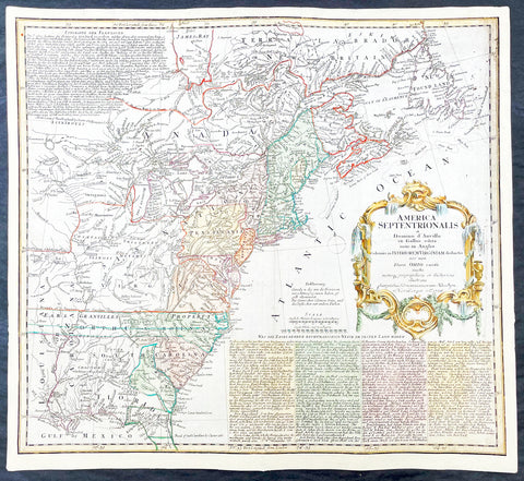
1756 Homann Antique Map Colonial United States North America French Indian War
Antique Map
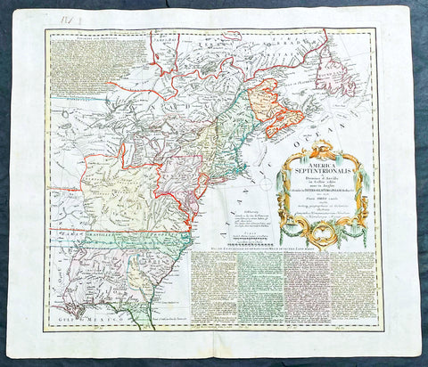
- Title : America Septentrionalis a domino d Anville in Galiis edita nunc in Anglia coloniis in interiorem Virginiam deductis nec non fluvii Ohio cursu aucta notisq geographicis et historicis illustrata.....1756
- Ref #: 17001
- Size: 21in x 19in (535mm x 480mm)
- Date : 1756
- Condition: (A) Very Good Condition
Description:
This original hand coloured copper-plate engraved antique 1st edition map of the Colonial United States, at the beginning of the French-Indian war, was engraved in 1756 - dated in cartouche - by the Homann firm, Germany.
First edition Homann map of the English Colonies in North America prior to the start of the French and Indian War. The map stretches just west of the Mississippi River to the east and from James Bay through the Great Lakes to the Gulf of Mexico. Although most of the text is in German, there is also much in English, including numerous place named annotations associated the French and Indian War, such as the locations of Fort Duquesne and Fort Necessity, both taken by the French in 1754. Thus although the cartographer credits D Anville for the basic cartography, it is clear he is drawing from English, not French, sources. Bottom right and upper left are notes offering the history of North America.
General Definitions:
Paper thickness and quality: - Heavy and stable
Paper color : - off white
Age of map color: - Original & later
Colors used: - Yellow, green, blue, pink
General color appearance: - Authentic
Paper size: - 21in x 19in (535mm x 480mm)
Plate size: - 21in x 19in (535mm x 480mm)
Margins: - Min 1/2in (12mm)
Imperfections:
Margins: - All margins extended from border
Plate area: - Light crease adjacent to centerfold, soiling in top right border
Verso: - Light soiling.
Background:
The French and Indian War (1754–63) comprised the North American theatre of the worldwide Seven Years War of 1756–63. It pitted the colonies of British America against those of New France. Both sides were supported by military units from their parent countries, as well as by American Indian allies. At the start of the war, the French North American colonies had a population of roughly 60,000 settlers, compared with 2 million in the British North American colonies. The outnumbered French particularly depended on the Indians. The European nations declared war on one another in 1756 following months of localized conflict, escalating the war from a regional affair into an intercontinental conflict.
The name French and Indian War is used mainly in the United States. It refers to the two enemies of the British colonists, the royal French forces and their various American Indian allies. The British colonists were supported at various times by the Iroquois, Catawba, and Cherokee, and the French colonists were supported by Wabanaki Confederacy members Abenaki and Mikmaq, and Algonquin, Lenape, Ojibwa, Ottawa, Shawnee, and Wyandot.
British and other European historians use the term the Seven Years War, as do English-speaking Canadians. French Canadians call it La guerre de la Conquête (the War of the Conquest) or (rarely) the Fourth Intercolonial War.
Fighting took place primarily along the frontiers between New France and the British colonies, from Virginia in the south to Newfoundland in the north. It began with a dispute over control of the confluence of the Allegheny River and Monongahela River called the Forks of the Ohio, and the site of the French Fort Duquesne in Pittsburgh, Pennsylvania. The dispute erupted into violence in the Battle of Jumonville Glen in May 1754, during which Virginia militiamen under the command of 22-year-old George Washington ambushed a French patrol.
In 1755, six colonial governors in North America met with General Edward Braddock, the newly arrived British Army commander, and planned a four-way attack on the French. None succeeded, and the main effort by Braddock proved a disaster; he lost the Battle of the Monongahela on July 9, 1755 and died a few days later. British operations failed in the frontier areas of Pennsylvania and New York during 1755–57 due to a combination of poor management, internal divisions, effective Canadian scouts, French regular forces, and Indian warrior allies. In 1755, the British captured Fort Beauséjour on the border separating Nova Scotia from Acadia, and they ordered the expulsion of the Acadians (1755–64) soon afterwards. Orders for the deportation were given by William Shirley, Commander-in-Chief, North America, without direction from Great Britain. The Acadians were expelled, both those captured in arms and those who had sworn the loyalty oath to His Britannic Majesty. Indians likewise were driven off the land to make way for settlers from New England.
The British colonial government fell in the region of modern Nova Scotia after several disastrous campaigns in 1757, including a failed expedition against Louisbourg and the Siege of Fort William Henry; this last was followed by Indians torturing and massacring their British victims. William Pitt came to power and significantly increased British military resources in the colonies at a time when France was unwilling to risk large convoys to aid the limited forces that they had in New France, preferring to concentrate their forces against Prussia and its allies in the European theater of the war. Between 1758 and 1760, the British military launched a campaign to capture the Colony of Canada (part of New France). They succeeded in capturing territory in surrounding colonies and ultimately the city of Quebec (1759). The British later lost the Battle of Sainte-Foy west of Quebec (1760), but the French ceded Canada in accordance with the Treaty of Paris (1763).
The outcome was one of the most significant developments in a century of Anglo-French conflict. France ceded to Great Britain its territory east of the Mississippi. It ceded French Louisiana west of the Mississippi River (including New Orleans) to its ally Spain in compensation for Spains loss to Britain of Florida. (Spain had ceded Florida to Britain in exchange for the return of Havana, Cuba.) Frances colonial presence north of the Caribbean was reduced to the islands of Saint Pierre and Miquelon, confirming Great Britains position as the dominant colonial power in eastern North America.
Please note all items auctioned are genuine, we do not sell reproductions. A Certificate of Authenticity (COA) can be issued on request.
1756 Homann Antique Map Colonial United States North America French Indian War
Antique Map
- Title : America Septentrionalis a domino d Anville in Galiis edita nunc in Anglia coloniis in interiorem Virginiam deductis nec non fluvii Ohio cursu aucta notisq geographicis et historicis illustrata.....1756
- Ref #: 27018
- Size: 24in x 21in (610mm x 535mm)
- Date : 1756
- Condition: (A) Very Good Condition
Description:
This original hand coloured copper-plate engraved antique 1st edition map of the Colonial United States, at the beginning of the French-Indian war, was engraved in 1756 - dated in cartouche - by the Homann firm, Germany.
This map has original margins and colour on heavy clean sturdy paper.
First edition Homann map of the English Colonies in North America prior to the start of the French and Indian War. The map stretches just west of the Mississippi River to the east and from James Bay through the Great Lakes to the Gulf of Mexico. Although most of the text is in German, there is also much in English, including numerous place named annotations associated the French and Indian War, such as the locations of Fort Duquesne and Fort Necessity, both taken by the French in 1754. Thus although the cartographer credits D Anville for the basic cartography, it is clear he is drawing from English, not French, sources. Bottom right and upper left are notes offering the history of North America.
General Definitions:
Paper thickness and quality: - Heavy and stable
Paper color : - off white
Age of map color: - Original & later
Colors used: - Yellow, green, blue, pink
General color appearance: - Authentic
Paper size: - 24in x 21in (610mm x 535mm)
Plate size: - 21in x 19in (535mm x 480mm)
Margins: - Min 1/2in (12mm)
Imperfections:
Margins: - Light staining in lower margins, bottom margin centerfold rejoined with transparent archival tape
Plate area: - Light age toning along centerfold
Verso: - None
Background:
The French and Indian War (1754–63) comprised the North American theatre of the worldwide Seven Years War of 1756–63. It pitted the colonies of British America against those of New France. Both sides were supported by military units from their parent countries, as well as by American Indian allies. At the start of the war, the French North American colonies had a population of roughly 60,000 settlers, compared with 2 million in the British North American colonies. The outnumbered French particularly depended on the Indians. The European nations declared war on one another in 1756 following months of localized conflict, escalating the war from a regional affair into an intercontinental conflict.
The name French and Indian War is used mainly in the United States. It refers to the two enemies of the British colonists, the royal French forces and their various American Indian allies. The British colonists were supported at various times by the Iroquois, Catawba, and Cherokee, and the French colonists were supported by Wabanaki Confederacy members Abenaki and Mikmaq, and Algonquin, Lenape, Ojibwa, Ottawa, Shawnee, and Wyandot.
British and other European historians use the term the Seven Years War, as do English-speaking Canadians. French Canadians call it La guerre de la Conquête (the War of the Conquest) or (rarely) the Fourth Intercolonial War.
Fighting took place primarily along the frontiers between New France and the British colonies, from Virginia in the south to Newfoundland in the north. It began with a dispute over control of the confluence of the Allegheny River and Monongahela River called the Forks of the Ohio, and the site of the French Fort Duquesne in Pittsburgh, Pennsylvania. The dispute erupted into violence in the Battle of Jumonville Glen in May 1754, during which Virginia militiamen under the command of 22-year-old George Washington ambushed a French patrol.
In 1755, six colonial governors in North America met with General Edward Braddock, the newly arrived British Army commander, and planned a four-way attack on the French. None succeeded, and the main effort by Braddock proved a disaster; he lost the Battle of the Monongahela on July 9, 1755 and died a few days later. British operations failed in the frontier areas of Pennsylvania and New York during 1755–57 due to a combination of poor management, internal divisions, effective Canadian scouts, French regular forces, and Indian warrior allies. In 1755, the British captured Fort Beauséjour on the border separating Nova Scotia from Acadia, and they ordered the expulsion of the Acadians (1755–64) soon afterwards. Orders for the deportation were given by William Shirley, Commander-in-Chief, North America, without direction from Great Britain. The Acadians were expelled, both those captured in arms and those who had sworn the loyalty oath to His Britannic Majesty. Indians likewise were driven off the land to make way for settlers from New England.
The British colonial government fell in the region of modern Nova Scotia after several disastrous campaigns in 1757, including a failed expedition against Louisbourg and the Siege of Fort William Henry; this last was followed by Indians torturing and massacring their British victims. William Pitt came to power and significantly increased British military resources in the colonies at a time when France was unwilling to risk large convoys to aid the limited forces that they had in New France, preferring to concentrate their forces against Prussia and its allies in the European theater of the war. Between 1758 and 1760, the British military launched a campaign to capture the Colony of Canada (part of New France). They succeeded in capturing territory in surrounding colonies and ultimately the city of Quebec (1759). The British later lost the Battle of Sainte-Foy west of Quebec (1760), but the French ceded Canada in accordance with the Treaty of Paris (1763).
The outcome was one of the most significant developments in a century of Anglo-French conflict. France ceded to Great Britain its territory east of the Mississippi. It ceded French Louisiana west of the Mississippi River (including New Orleans) to its ally Spain in compensation for Spains loss to Britain of Florida. (Spain had ceded Florida to Britain in exchange for the return of Havana, Cuba.) Frances colonial presence north of the Caribbean was reduced to the islands of Saint Pierre and Miquelon, confirming Great Britains position as the dominant colonial power in eastern North America.
Please note all items auctioned are genuine, we do not sell reproductions. A Certificate of Authenticity (COA) can be issued on request.
1765 Homann Large Antique Map of The Zurich Canton, Switzerland - Tigurini
Antique Map
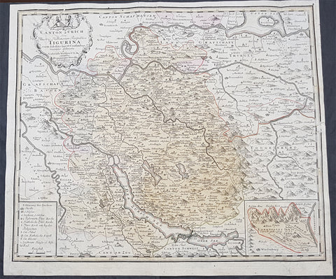
- Title : Canton Zurich sive Illustratis Helvetiorum Respublica Tigurina...1765
- Ref #: 50175
- Size: 23 1/2in x 20in (595mm x 510mm)
- Date : 1765
- Condition: (B) Good Condition
Description:
This large original hand coloured copper plate engraved antique map of the Zurich Canton of Switzerland, the hoome of the Tigurini Tribe of Helvetii, by the Homann firm was engraved in 1765 - dated.
General Definitions:
Paper thickness and quality: - Heavy and stable
Paper color : - off white
Age of map color: - Original
Colors used: - Yellow, orange
General color appearance: - Authentic
Paper size: - 23 1/2in x 20in (595mm x 510mm)
Plate size: - 22in x 19in (560mm x 485mm)
Margins: - Min 1/2in (12mm)
Imperfections:
Margins: - Small repair to top and left margins
Plate area: - None
Verso: - Soiling and re-enforced to the left of the verso
Background:
The Tigurini were a clan or tribe forming one out of four pagi (provinces) of the Helvetii.[1][2] The Tigurini were the most important group of the Helvetii, mentioned by both Caesar and Poseidonius, settling in the area of what is now the Swiss canton of Vaud, corresponding to the bearers of the late La Tène culture in western Switzerland. Their name has a meaning of lords, rulers (cognate with Irish tigern lord). The other Helvetian tribes included the Verbigeni and the Tougeni (sometimes identified with the Teutones), besides one tribe that has remained unnamed.
1784 Homann Large Antique Map of The Newly Formed United States of America
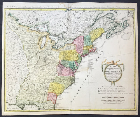
- Title : Charte uber die XIII vereinigte Staaten von Nord-Amerika...F L Guffefeld...A 1784
- Ref #: 61031
- Size: 23 1/4in x 19 1/4in (590mm x 490mm)
- Date : 1784
- Condition: (A) Very Good Condition
Description:
This large important & scarce fine beautifully hand coloured original antique map of the United States just after the War of Independence was engraved by F.J. Guttefeld in 1784 - dated - and published by the famous German firm of Homann Heirs.
Also known as the Stetson map, after the Stetson engraved in the title cartouche, this is one of the earliest maps to recognised the newly independent United States after the revolutionary war of Independence.
Background: An early and large map of the newly formed United States delineating all 13 states. The map extends west past the Mississippi River and north to the southern tip of Hudson Bay. The southern states are shown with their western boundaries on the Mississippi River, although the coloring shows only regions east of the Appalachians as being organized. As with many German maps of the period, there are some incorrect state boundaries; Vermont is shown as part of New Hampshire, and Maryland includes much of northern Virginia. A list of the principal German communities in New York, New Jersey and Pennsylvania are listed. The interior regions are shown with considerable topographical detail, locating numerous Indian tribes, topography, and watershed. The uncolored garland-style title cartouche is topped with a hat and crossed swords.
Each state is colored in a contrasting pastel and the states in the northern part are named by way of a lettered key given just below the attractive title cartouche. The treatment of the lands to the west of the Appalachian Mountains and up to the Mississippi River is quite interesting. This area is indicated as lands that came to the United States by the Treaty of 1783.French title outside top neat-line: Les XIII Etats Unis de l' Amerique Septentrionale. Ref: Tooley; M&B)
General Description:
Paper thickness and quality: - Heavy and stable
Paper color: - off white
Age of map color: - Original
Colors used: - Yellow, green, blue, pink
General color appearance: - Authentic
Paper size: - 23 1/4in x 19 1/4in (590mm x 490mm)
Plate size: - 23in x 18 1/4in (685mm x 465mm)
Margins: - Min 1/2in (12mm)
Imperfections:
Margins: - Light soiling in top margin,
Plate area: - Light creasing along centerfold, light soiling
Verso: - Re-enforced along centerfold