
Jean-François de Galaup La Perouse (1741-1788)
La Perouse was born in Albi, France. He entered the navy at 15 and when serving in the Formidable in the battle with Admiral Hawke off Belle-Isle in November 1759 was wounded and captured. Repatriated from England he was posted again to sea duties, where he perfected his techniques as a seaman and navigator and pursued his interest in oceanography. Promoted lieutenant in April 1775 and captain in 1780 after France joined the American war, he had opportunities to distinguish himself as a naval commander. His campaign against the British in Hudson Bay in August 1782 was a signal success, and he demonstrated his humanity by leaving with the remnants of the settlements enough arms and provisions to enable them to preserve themselves during the oncoming winter.
In 1783 the French government resolved to send an expedition to the Pacific to complete Captain James Cook's unfinished work, and in particular to explore the passages in the Bering Sea, which had been a mystery to Europeans since the sixteenth century. King Louis XVI himself took a hand in drafting the plan and itinerary, a copy of which is in the Municipal Library at Rouen, France, and when La Pérouse was selected to lead the fleet gave him an audience before he sailed. In command of two ships, La Boussole and L'Astrolabe (Commandant de Langle), he left Brest on 1 August 1785 making for Brazil. Doubling Cape Horn he refitted in Chile, then sailed to the Sandwich Islands and thence to Alaska, where he turned south exploring and surveying the coast as far as California. After a short refit at Monterey, he sailed across the Pacific, discovered uncharted islands, and visited Macao and Manila. After six weeks reprovisioning and refreshing he left on 10 April 1787 to survey the coasts and territories north of Korea, which had been described and commented on by Christian missionaries. He sailed up the Gulf of Tartary, naming several points on both its shores and learned that Sakhalin was an island. In September he put in to Kamchatka to replenish his supplies. From there he dispatched an officer, Lesseps, overland to Paris with accounts of his discoveries, while he turned south making for New Holland. In December, at Tutuila, Samoa, which Bougainville had called the Navigator Islands when he explored them in 1768, natives suddenly attacked a party from L'Astrolabe seeking water and killed de Langle and eleven others. La Pérouse left without taking reprisals and sailed through the Pacific Islands to Norfolk Island and to Botany Bay. He was sighted off the coast there on 24 January 1788 but bad weather prevented his entering the bay for two days. By then Governor Arthur Phillip had sailed to Port Jackson, but John Hunter had remained with the Sirius and the transports, and assisted La Pérouse to anchor. He established a camp on the northern shore, now called after him, and maintained good relations with the English during his six-week stay. He sailed on 10 March and was not heard of again. His disappearance led the French government in 1791 to equip another expedition under Bruny d'Entrecasteaux to look for him, but the search was fruitless.
As Franco-British relations deteriorated during the revolution unfounded rumours spread in France blaming the British for the tragedy which had occurred in the vicinity of the new colony. It was not until 1828 that the mystery was solved, when Dumont d'Urville ascertained that the La Pérouse expedition was wrecked at Vanikoro, Santa Cruz, north of the New Hebrides. In the meantime the revolutionary government had published the records of the voyage as far as Kamchatka: Voyage De La Pérouse Autour du Monde, 1-4 (Paris, 1797). These volumes are still mines of cartographic and scientific information about the Pacific. Three English translations were published during 1798-99. An anonymous pamphlet Fragmens du Dernier Voyage de la Pérouse (Quimper, 1797), may have been the work of Pére Receveur, a scientist on the expedition who died at Botany Bay on 17 February 1788.
On 17 June 1783 La Pérouse had married Louise-Eléonore Brander of Nantes. They had no children but since his name was taken in 1815 by the husbands of his two sisters, Dalmas and Barthez, it still survives in France.
Jean Francois La Perouse (1)
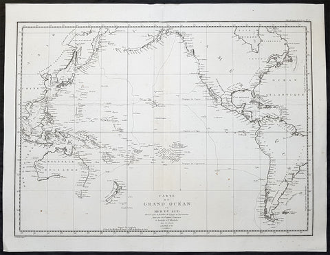
1797 La Perouse Large Original Antique Map of Australia, America & The Pacific
- Title : Carte Du Grand Ocean ou Mer du Sud Dressee pour la Relation du Voyage de Decouvertes faites par les Fregates Francaises la Boussole et l Astrolabe dans les Annees 1785, 86, 87 et 88
- Size: 29 1/2in x 23in (750mm x 585mm)
- Ref #: 82004
- Date : 1797
- Condition: (A+) Fine Condition
Description:
This large original, antique & important map of Australia, America and The Pacific illustrating the exploration of Jean-Francois de Galaup, Comte de La Perouse, after Captain Cook, was engraved by the famous French engraver Pierre Tardieu and was published after La Perouse, in Paris, 1797.
In 1783 the French government appointed La Perouse in command of an expedition to the Pacific to complete Captain James Cook\'s unfinished work, and in particular to explore the passages in the Bering Sea, which had been a mystery to Europeans since the 16th century. In command of two ships, La Boussole and L Astrolabe he made for Brazil on the 1st of August 1785. Rounding Cape Horn he refitted in Chile, then sailed to the Hawaiian Islands (Sandwich Islands) and onto Alaska, where he turned south exploring and surveying the NW coast as far as California. After a short refit at Monterey California, he sailed across the Pacific, discovered many uncharted islands, and visited Macao and Manila.
After six weeks re provisioning, he left on 10 April 1787 to survey the coasts and territories north of Korea, which had been described by Christian missionaries. He sailed up the Gulf of Tartary, naming several points on both its shores and learned that Sakhalin was an island. In September he put in to Kamchatka to replenish his supplies. From there he turned south making for Australia (New Holland). In December, at Tutuila, Samoa, which Bougainville had called the Navigator Islands when he explored them in 1768, natives suddenly attacked a party from L Astrolabe, seeking water. La Perouse left without taking reprisals and sailed through the Pacific Islands to Norfolk Island and to Botany Bay. He was sighted off the coast there on 24 January 1788 but bad weather prevented his entering the bay for two days. La Perouse established a camp at Botany Bay on the northern shore, now named after him. After his six-week stay he sailed on 10 March and was not heard of again.
General Definitions:
Paper thickness and quality: - Heavy and stable
Paper color : - off white
Age of map color: -
Colors used: -
General color appearance: -
Paper size: - 29 1/2in x 23in (750mm x 585mm)
Plate size: - 29 1/2in x 23in (750mm x 585mm)
Margins: - Min 1in (25mm)
Imperfections:
Margins: - None
Plate area: - None
Verso: - None
Background:
The map highlights La Perouse\'s Voyage from France, around Cape Horn, then to Hawaii and the Northwest Coast of America, south to Oregon, San Francisco and Monterey, then across the Pacific Ocean to Canton, through the Philippines to the Sea of Japan and the Northern Japanese Islands, then to Kamchatka.
From Kamchatka, La Perouse proceeded to the South Pacific and finally to Port Jackson and Botany Bay, where he met his untimely death. The map displays the most up to date cartography, especially along the Northwest Coast of America, Northeast Coast of Asia, Australia, New Zealand and the Pacific.
La Perouse arrived in Botany Bay in 1788, where he was welcomed by the British and stayed six weeks, during which time he arranged for his records to be sent back to Europe. He then set sail, saying he would be back in Paris by June 1789, but none of his crew were ever seen again. In 1826 evidence of the fate of the expedition was found on Vanikoro in the Santa Cruz group of islands. In 2005, it was proved the Boussole and Astrolabe had hit the reefs there and sank.
La Perouse\'s voyage is perhaps second only to the Voyages of James Cook for its impact on cartographic knowledge and discoveries in the Pacific during the second half of the 18th Century.