
Jean Baptiste Bourguignon D'Anville (1697-1782)
Profile :
Following the death of Guillaume Delisle, D'Anville continued the line of progressive French cartographers which had begun with Nicolas Sanson in the previous century.
He is said to have designed his first map at the age of fifteen and in a long and active life he produced a great number of elegantly engraved maps, noted for their scholarship and accuracy. If anything, he was even more critical of the work of his predecessors than Delisle and his exacting standards soon brought him international recognition as the finest cartographer of his time. In fact, during his whole life he never travelled outside Paris but he built up a vast collection of cartographic material which eventually was passed to the Bibliotheque Nationale.
He was specially interested in the geography of the East and he designed maps for a Description geographique de Ia Chine by Pere J. B. du Halde (1735), a notable work of the day based on surveys and reports of Jesuit missionaries. These maps were also issued in Nouvel Atlas de Ia Chine in 1737 and were the first to give a reasonably accurate picture of that remote land. From about 1740 onwards he published collections of maps under the title Atlas Generate which went through numerous expanding editions in various languages; English editions were printed by Robert Sayer, Laurie and Whittle, and others into the next century
Jean Baptiste Bourguignon d' Anville (2)
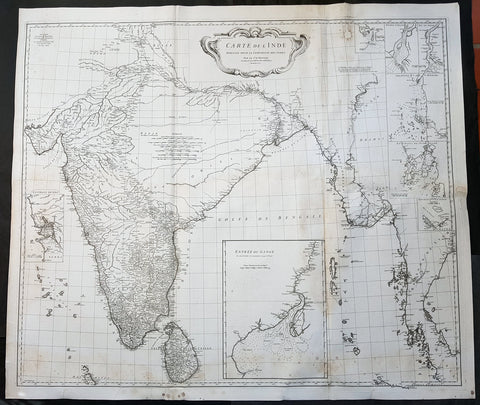
1752 D Anville Large Original Antique Map of India Sri Lanka Burma Siam - Scarce
Antique Map
- Title : Carte De L Inde Dressee Pour La Compagnie Des Indes...1752
- Size: 43in x 37 1/2in (1.1m x 950mm)
- Ref #: 92320
- Date : 1752
- Condition: (A) Very Good Condition
Description:
This large finely engraved scarce and highly detailed original antique map of India, Sri Lanka Burma & Thailand was engraved by Guillaume de la Haye in 1752 - dated in the tile cartouche - and was published in Jean-Baptiste Bourguinon D\'Anville\'s large elephant folio atlas Atlas Generale.
General Definitions:
Paper thickness and quality: - Heavy and stable
Paper color : - off white
Age of map color: -
Colors used: -
General color appearance: -
Paper size: - 43in x 37 1/2in (1.1m x 950mm)
Plate size: - 41in x 35in (1.04m x 890mm)
Margins: - Min 1in (25mm)
Imperfections:
Margins: - Spotting
Plate area: - Spotting, aging toning along folds as issued
Verso: - Spotting, aging toning along folds as issued
Background:
The map is drawn from numerous sources, including Ptolemy, Turkish and Indian geographies, and Jesuit surveys. More contemporary works by Bouchet in 1719 and Boudier in 1734 are seen both in the detail and inset river maps. The map reflects the level of knowledge of India & SE Asia at the time, especially of the interiors. The map has excellent detail of Southern India and coastlines were trade had been happening for centuries, but a conspicuous absence of detail of the northern interior
There are seven Inset maps that include the environs of Goa, entrance of the Ganges River and a wonderfully detailed depiction of the entrance to the Hugli River and other river tributes.
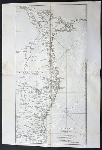
1753 D Anville Large Original Antique Map of SE Coromandel Coast of India - Rare
- Title : Coromandel par Le Sr D Anville...1753
- Size: 39 1/2in x 27in (1.1m x 685mm)
- Ref #: 92321
- Date : 1753
- Condition: (A) Very Good Condition
Description:
This large finely engraved scarce and highly detailed original antique map of South East Coast of India, the Coromandel Coast was engraved by Guillaume de la Haye in 1753 - dated in the tile cartouche - and was published in Jean-Baptiste Bourguinon D\'Anville\'s large elephant folio atlas Atlas Generale.
General Definitions:
Paper thickness and quality: - Heavy and stable
Paper color : - off white
Age of map color: -
Colors used: -
General color appearance: -
Paper size: - 39 1/2in x 27in (1.1m x 685mm)
Plate size: - 38in x 19 1/2in (970mm x 495mm)
Margins: - Min 1/2in (12mm)
Imperfections:
Margins: - Light spotting to right of image
Plate area: - Light spotting to right of image
Verso: - Light spotting to right of image
Background:
The Coromandel Coast is the southeastern coast region of the Indian Subcontinent, between the Eastern Ghats and the Bay of Bengal of the Indian Ocean. The coastline runs between False Divi Point in the north to Kanyakumari in the south. Its definition can also include the northwestern coast of the island of Sri Lanka.
By late 1530 the Coromandel Coast was home to three Portuguese settlements at Nagapattinam, São Tomé de Meliapore, and Pulicat. Later, in the 17th and 18th centuries, the Coromandel Coast was the scene of rivalries among European powers for control of the India trade. The British established themselves at Fort St George (Madras) and Masulipatnam, the Dutch at Pulicat, Sadras and Covelong, the French at Pondicherry, Karaikal and Nizampatnam, the Danish in Dansborg at Tharangambadi.
The Coromandel Coast supplied Indian Muslim eunuchs to the Thai palace and court of Siam (modern Thailand). The Thai at times asked eunuchs from China to visit the court in Thailand and advise them on court ritual since they held them in high regard.
Eventually the British won out, although France retained the tiny enclaves of Pondichéry and Karaikal until 1954. Chinese lacquer goods, including boxes, screens, and chests, became known as \"Coromandel\" goods in the eighteenth century, because many Chinese exports were consolidated at the Coromandel ports.