
Jean Baptiste Bourguignon D'Anville (1697-1782)
Profile :
Following the death of Guillaume Delisle, D'Anville continued the line of progressive French cartographers which had begun with Nicolas Sanson in the previous century.
He is said to have designed his first map at the age of fifteen and in a long and active life he produced a great number of elegantly engraved maps, noted for their scholarship and accuracy. If anything, he was even more critical of the work of his predecessors than Delisle and his exacting standards soon brought him international recognition as the finest cartographer of his time. In fact, during his whole life he never travelled outside Paris but he built up a vast collection of cartographic material which eventually was passed to the Bibliotheque Nationale.
He was specially interested in the geography of the East and he designed maps for a Description geographique de Ia Chine by Pere J. B. du Halde (1735), a notable work of the day based on surveys and reports of Jesuit missionaries. These maps were also issued in Nouvel Atlas de Ia Chine in 1737 and were the first to give a reasonably accurate picture of that remote land. From about 1740 onwards he published collections of maps under the title Atlas Generate which went through numerous expanding editions in various languages; English editions were printed by Robert Sayer, Laurie and Whittle, and others into the next century
Jean Baptiste Bourguignon d' Anville (3)
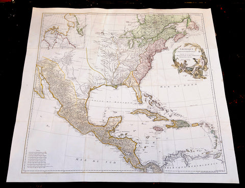
1746 D Anville Large Antique Map of North America - Pre French Indian & Rev. War
Antique Map
-
Title : Amerique Septentrionale Publiee sous les Auspices de Monseigneur le Duc d Orleans.. Par Le Snr. D Anville MDCCXLVI
- Ref #: 17010
-
Condition: (A+) Fine Condition
- Size: 42 1/2in x 37in (1.08m x 940mm)
- Date : 1746
Description:
This large important original copper plate engraved hand coloured antique map of North America, in 12 sheets joined, was engraved in 1746 - dated in the cartouche - and was published by Jean-Baptiste Bourguinon D Anville in his Elephant Folio Atlas Generale.
This map was instrumental in instructing the European Colonial powers of the time, England France & Spain the importance of dominating the New World, that ultimately led to the French and Indian War of 1754–63. This conflict determined the political direction of North America leading to the American War of Independence in 1775 and ultimately the formation of The United States of America.
To illustrate the importance of cartography in the mid eighteenth century, especially that of North America, a J B D Anville map is essential. D Anville dominated 18th century European cartography with many of his cartographical achievements, especially in North America, copied by many of his contemporaries such as Kitchen, Sayer, Homann, Seutter, Mitchell and others .
He was one of the first to leave blank spaces in his maps, where knowledge was scant or insufficient. His representation of the great lakes is superior to that of his contemporary John Mitchell, responsible for publishing one of the most famous mid 18th century maps of North America, A Map of the British and French Dominions in North America on 8 sheets in 1755 and remained the standard map of North America up until the end of the 18th century. (Ref: Tooley, Printed maps of America, 104; The Mapping of America 316)
General Definitions:
Paper thickness and quality: - Heavy and stable
Paper color : - off white
Age of map color: - Original & later
Colors used: - Red, yellow, green, blue
General color appearance: - Authentic
Paper size: - 42 1/2in x 37in (1.08m x 940mm)
Plate size: - 34 1/2in x 33 1/2in (875m x 850mm)
Margins: - Min 1in (25mm)
Imperfections:
Margins: - Small restoration to left margin, not affecting the image
Plate area: - None
Verso: - Age toning
Background:
The French and Indian War (1754–63) comprised the North American theatre of the worldwide Seven Years War of 1756–63. It pitted the colonies of British America against those of New France. Both sides were supported by military units from their parent countries, as well as by American Indian allies. At the start of the war, the French North American colonies had a population of roughly 60,000 settlers, compared with 2 million in the British North American colonies. The outnumbered French particularly depended on the Indians. The European nations declared war on one another in 1756 following months of localized conflict, escalating the war from a regional affair into an intercontinental conflict.
The name French and Indian War is used mainly in the United States. It refers to the two enemies of the British colonists, the royal French forces and their various American Indian allies. The British colonists were supported at various times by the Iroquois, Catawba, and Cherokee, and the French colonists were supported by Wabanaki Confederacy members Abenaki and Mikmaq, and Algonquin, Lenape, Ojibwa, Ottawa, Shawnee, and Wyandot.
British and other European historians use the term the Seven Years War, as do English-speaking Canadians. French Canadians call it La guerre de la Conquête (the War of the Conquest) or (rarely) the Fourth Intercolonial War.
Fighting took place primarily along the frontiers between New France and the British colonies, from Virginia in the south to Newfoundland in the north. It began with a dispute over control of the confluence of the Allegheny River and Monongahela River called the Forks of the Ohio, and the site of the French Fort Duquesne in Pittsburgh, Pennsylvania. The dispute erupted into violence in the Battle of Jumonville Glen in May 1754, during which Virginia militiamen under the command of 22-year-old George Washington ambushed a French patrol.
In 1755, six colonial governors in North America met with General Edward Braddock, the newly arrived British Army commander, and planned a four-way attack on the French. None succeeded, and the main effort by Braddock proved a disaster; he lost the Battle of the Monongahela on July 9, 1755 and died a few days later. British operations failed in the frontier areas of Pennsylvania and New York during 1755–57 due to a combination of poor management, internal divisions, effective Canadian scouts, French regular forces, and Indian warrior allies. In 1755, the British captured Fort Beauséjour on the border separating Nova Scotia from Acadia, and they ordered the expulsion of the Acadians (1755–64) soon afterwards. Orders for the deportation were given by William Shirley, Commander-in-Chief, North America, without direction from Great Britain. The Acadians were expelled, both those captured in arms and those who had sworn the loyalty oath to His Britannic Majesty. Indians likewise were driven off the land to make way for settlers from New England.
The British colonial government fell in the region of modern Nova Scotia after several disastrous campaigns in 1757, including a failed expedition against Louisbourg and the Siege of Fort William Henry; this last was followed by Indians torturing and massacring their British victims. William Pitt came to power and significantly increased British military resources in the colonies at a time when France was unwilling to risk large convoys to aid the limited forces that they had in New France, preferring to concentrate their forces against Prussia and its allies in the European theater of the war. Between 1758 and 1760, the British military launched a campaign to capture the Colony of Canada (part of New France). They succeeded in capturing territory in surrounding colonies and ultimately the city of Quebec (1759). The British later lost the Battle of Sainte-Foy west of Quebec (1760), but the French ceded Canada in accordance with the Treaty of Paris (1763).
The outcome was one of the most significant developments in a century of Anglo-French conflict. France ceded to Great Britain its territory east of the Mississippi. It ceded French Louisiana west of the Mississippi River (including New Orleans) to its ally Spain in compensation for Spains loss to Britain of Florida. (Spain had ceded Florida to Britain in exchange for the return of Havana, Cuba.) Frances colonial presence north of the Caribbean was reduced to the islands of Saint Pierre and Miquelon, confirming Great Britains position as the dominant colonial power in eastern North America.
Please note all items auctioned are genuine, we do not sell reproductions. A Certificate of Authenticity (COA) can be issued on request.
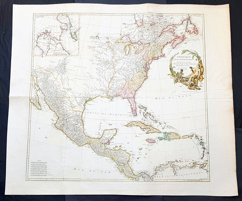
1746 J B D Anville Large Antique Map of North America
- Title : Amerique Septentrionale Publiee sous les Auspices de Monseigneur le Duc d 'Orleans.. Par Le Snr. D Anville MDCCXLVI
- Date : 1746
- Condition: (A+) Fine Condition
- Ref: 93207
- Size: 42 1/2in x 37in (1.08m x 940mm)
Description:
This spectacular large original copper plate engraved antique map of North America by Jean-Baptiste Bourguinon D Anville was in 1746 - dated - and was published in his elphant folio Atlas Generale.
General Definitions:
Paper thickness and quality: - Heavy and stable
Paper color : - off white
Age of map color: - Original & later
Colors used: - Blue, pink, red, green, yellow
General color appearance: - Authentic
Paper size: - 42 1/2in x 37in (1.08m x 940mm)
Plate size: - 34 1/2in x 33 1/2in (875m x 850mm)
Margins: - Min 2in (50mm)
Imperfections:
Margins: - Light spotting in margins
Plate area: - Folds as issued
Verso: - Folds as issued
Background:
To illustrate the cartography of the mid eighteenth century, especially American cartography, a D Anville map is essential. He dominated not only the French but all contemporary European cartography. He was foremost to leave blank spaces in his maps where knowledge was insufficient. His representation of the great lakes is superior to that of his contemporary John Mitchell who was responsible for publishing one of the most famous mid 18th century maps A Map of the British and French Dominions in North America on 8 sheets London in 1755. It was the standard map of North America up until the end of the century.
Eusebio Francisco Kinos discoveries of California in the beginning of the 18th century have now made full impact. D Anvilles map shows California as a peninsula and the Colorado and Gila Rivers are more accurately located. Note that the western part of the Gila River is named the Rio Grande, the Santa Cruz River is called Sta. Maria, and the San Pedro River is Terenate. (Ref: Tooley, Printed maps of America, 104; The Mapping of America 316)
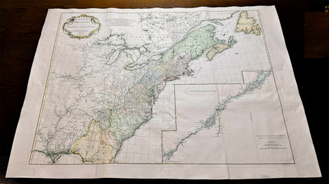
1755 D 'Anville Large Antique Map of North America, Great Lakes, 13 Colonies
Antique Map
- Title : Canada Louisiane et Terres Anglois Par Le Sr. D Anville...MDCCLV
- Ref #: 61140
- Size: 52in x 38in (1.32m x 960mm)
- Date : 1755
- Condition: (A+) Fine Condition
Description:
This magnificent, scarce, very large (52in x 38in) hand coloured & highly detail map of North America was engraved in 1755 - dated in the title cartouche - by George De La Haye and was published by Jean Baptiste Bourguignon D Anville in his large elephant folio atlas Atlas Generale.
Geopolitically this map is extremely significant drawn as war between the Global Powers of the day, France, England & Spain, was breaking, known in Europe as the Seven Year War known in North America as the French & Indian war. (Please see below for more detail)
This map rivals John Mitchells "A Map of the British and French Dominions in North America published in 1755" - considered to be one of the most significant maps of North America published in the 18th & 19th centuries (a 1st edition of Mitchells map is currently for sale for $165,000).
I have included an image of the Mitchell map for comparison. The D Anville map is considered by many to be cartographically superior to the Mitchell map, at a fraction of the price.
General Description:
Paper thickness and quality: - Heavy and stable
Paper color: - White
Age of map color: - Early & later
Colors used: - Pink, yellow, green
General color appearance: - Authentic
Paper size: - 52in x 38in (1.32m x 960mm)
Plate size: - 45in x 35in (1.12m x 890mm)
Margins: - Min 1in (25mm)
Imperfections:
Margins: - None
Plate area: - Light ceasing along folds
Verso: - Very small worm holes
Background: This extraordinary map of the eastern half of North America extends from Newfoundland, Canada to St. Augustine, Florida, stretching westward beyond the Mississippi as far as modern day Texas. The map includes both the original colonial colonies along the Atlantic seaboard from Maine to Georgia and the French claims in Louisiana (the Mississippi Valley) and modern day Canada. Florida is acknowledged as a Spanish enclave. Elevation is rendered in profile with fortifications, towns, and American Indian villages identified. A large inset map centres on the course of the St. Lawrence River from the Isle Aux Coudres to Lake Ontario.
The is a very significant map, drawn from a definitive French perspective, defining the territorial alignments and claims within North America shortly following the outbreak of the French and Indian War, considered to be a New World reflection of the European Seven Years War. It is however notable that it began before the larger hostilities in Europe and most of the major battles involved primarily parties only loosely aligned with the French or English - most specifically American Indians and lawless frontiersman, who had their own political agenda.
The war began with French incursions into western Pennsylvania and other territories claimed simultaneously by the French, English and American Indian forces. Just prior to the war, the French, in the interest of broadening their hold on the lucrative fur trade, established a series of forts, all of which are here noted, along the length of the Mississippi and further east, including Fort Duquesne (here Fort de Quene, Pittsburgh), Fort de la Presquisle, and for Le Beouf (here, Fort de la Riv Jaus Beufs).
The map also recognizes British claims, only inland as far as the Appalachian Mountains, beyond which place names take on a noticeably French character. These last three forts occupied particularly contested territory under the control of the powerful British allied Iroquois League. The most contested of these was Fort Duquesne (modern day Pittsburgh) in direct opposition to another fort then being constructed by the Ohio Company, a trading and land speculation firm established by prominent Virginia colonials, including George Washington. The Virginian colonial governor responded to Duquesne by sending then Lieutenant George Washington and a band of Virginia militiamen to harass the French. The resulting Jumonville Affair, in which Washington oversaw an attack on a French Canadian diplomatic forces led by Joseph Coulon de Villiers de Jumonville, to warn the Ohio Company fort builders away from French claimed territory. The slaying of Jumonville and several other French diplomats prompted a response from French forces at Fort Duquesne, leading to Washingtons retreat and construction of Fort Necessity, really little more than a palisaded shack, marked here just south of Fort Duquesne. These events, all of which occurred in May of 1754, were said to have increased hostilities in Europe and led to the start of the Seven Year War in 1755.
Beyond the political agenda of this map, is the map itself, being one of the finest and most heavily detailed maps of North America published in the mid 18th century. Ranking alongside the large 1755 Mitchell map in detail but judged by many as cartographically superior. Drawing on both French and British cartographical detail, D Anville identifies countless American Indian tribes, many of which, like the Sioux and Missouri, the British had only vague knowledge. Moreover, he also includes detail such as swamps, rapids, fords, abandoned villages, and even the ancient remnants of mound builder culture in the Ohio Valley. D Anville notably does not include Mitchells fictional Lake Superior islands.
This map was originally published to accompany the pamphlet entitledMemoire sur la carte intitulee: Canada, Louisiane, & Terres angloises and was also published in four parts for D Anvilles Atlas General.
These large maps are hard to find in such good condition and make fantastic historical reference tools due to the size and high level of detail as with all D Anvilles work. (Ref: Tooley, M&B)