
Fredrick de Wit (1630-1706)
Profile : De Wit was one of the most prominent and successful map engravers and publishers in Amsterdam in the period following the decline of the Blaeu and Jansson establishments, from which he acquired many copper plates when they were dispersed at auction. His output covered most aspects of map making: sea charts, world atlases, an atlas of the Netherlands, 'town books' covering plans of towns and cities in the Netherlands and Europe, and wall maps. His work, notable for the beauty of the engraving and colouring, was very popular with Covens and Mortier issuing many editions years after his death.
Fredrick de Wit
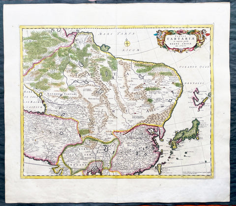
1680 Frederick de Wit Large Antiue Map of Tartary, China, Japan, Mogul, Formosa
Antique Map
- Title : Magnae Tartariae Magni Mogolis Imperii, Japoniae et Chinae...F de Wit
- Ref #: 17030
- Size: 25in x 22 1/2in (635mm x 570mm)
- Date : 1680
- Condition: (A+) Fine Condition
Description:
This large, handsome original hand coloured copper plate engraved antique map of Tartary including China, Japan, Central Asia, parts of the Mogul Empire, Persia and Siberia - was published by Fredrick De Wit in 1680.
The map is finely engraved with detail, with fine original colour on sturdy, strong paper.
General Definitions:
Paper thickness and quality: - Heavy and stable
Paper color : - off white
Age of map color: - Early
Colors used: - Yellow, orange
General color appearance: - Authentic
Paper size: - 25in x 22 1/2in (635mm x 570mm)
Plate size: - 22in x 17 1/2in (560mm x 445mm)
Margins: - Min 1in (25mm)
Imperfections:
Margins: - Light age toning
Plate area: - Light age toning
Verso: - Light age toning
Background:
Although Arabia, Persia, the Silk road to China and those parts of Northern India conquered by Alexander the Great were known to the classical world, it was not until the year AD 1375 that a map giving some idea of the real shape and size of Asia was compiled. This was the famous Catalan Map, based on reports of Franciscan missionaries and the writings of Marco Polo. A century or so later in the first Ptolemaic Atlases, there were altogether twelve maps of Asia which, of course, revealed no more or less than Ptolemy's view of the Ancient world, but in the expanded Waldseemuller editions of 1513 and 1532 there were modern regional maps including much information from Marco Polo's travels.
Later 16th century maps continue to show many of the distorted outlines copied from Ptolemy although by this time India, Ceylon and the Indies were gaining more recognizable shape. Munster was again the first publisher to print a separate map of Asia and later Ortelius issued the first separately printed map of China in 1584 and Japan in 1595. In the next century highly decorative maps were published by Van Den Keere in 1614, Speed 1627, Blaeu 1630, De Wit 1660, Visscher 1680 and others too numerous to list. (Ref: Tooley, M&B)