Welcome to Classical Images!
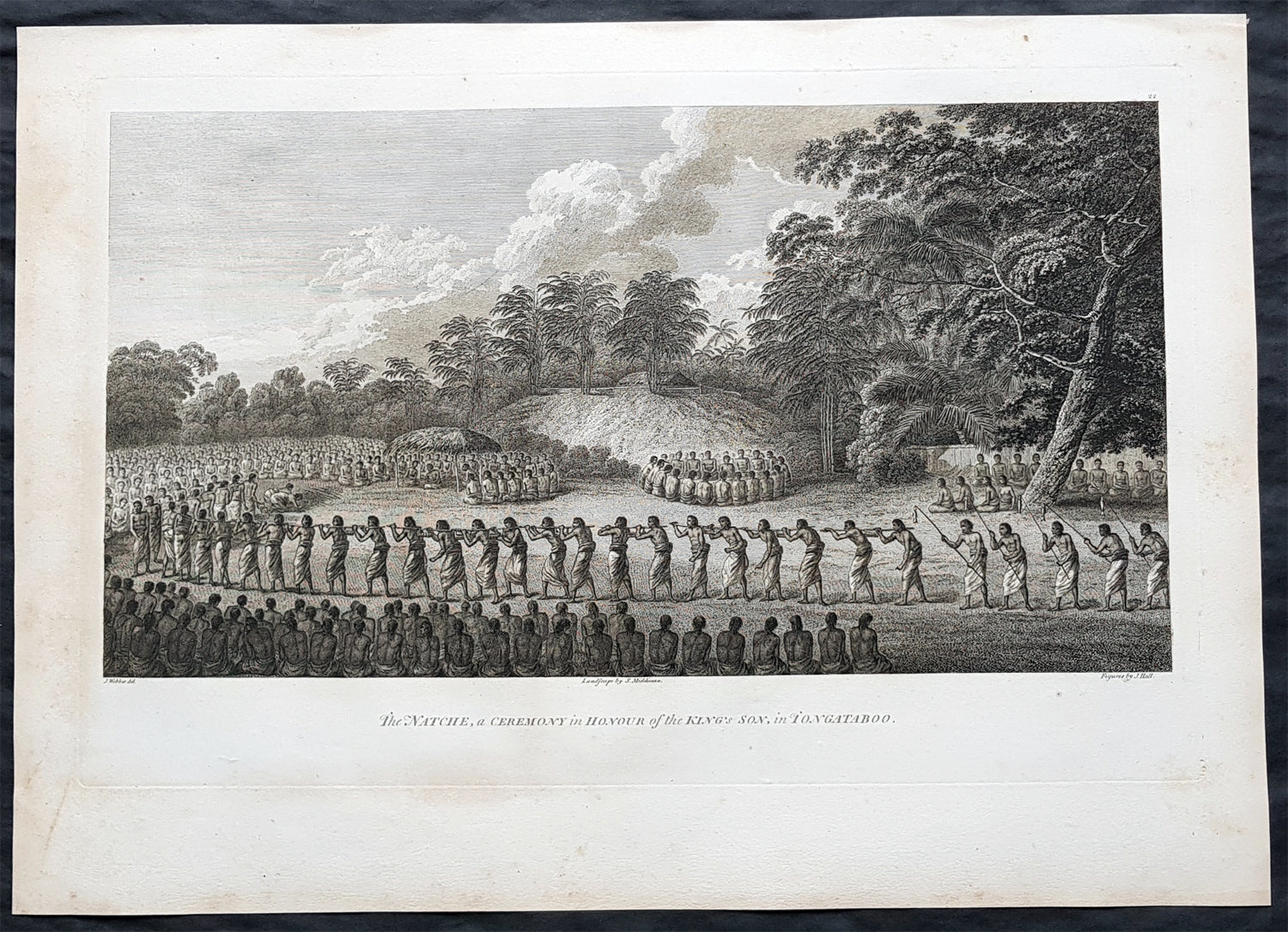
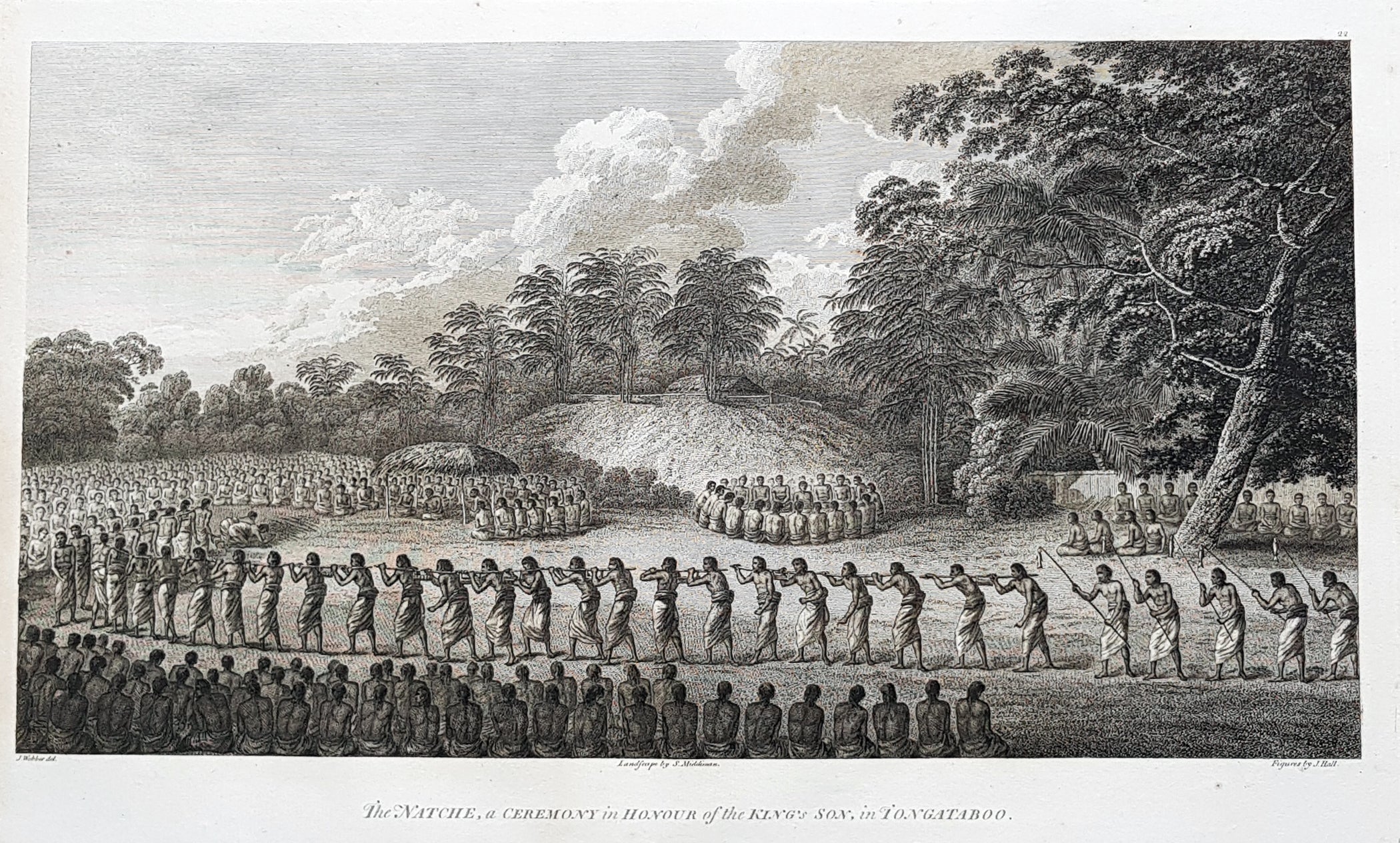
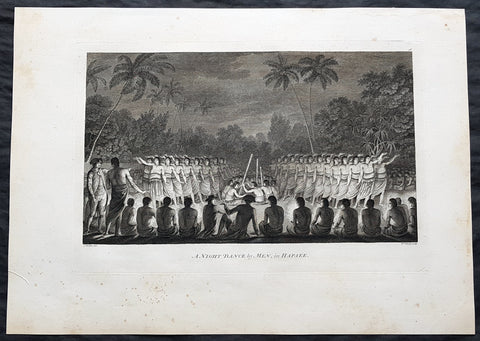
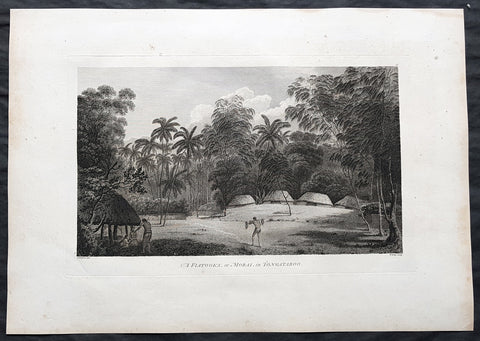
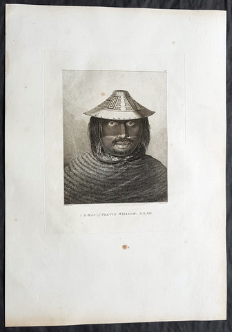
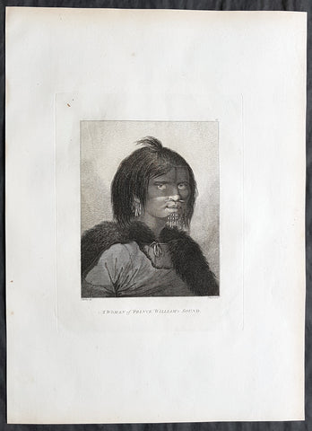
Description:This large beautifully engraved original copper-plate 1st edition antique print of possibly the coming of age or Inasi ceremony for the son of the King of Tonga in the village of Mua on the main Tongan Island of Tongatapu, at the time of Captain Cooks visit in 1777 as drawn by John Webber (Cooks official artist on the voyage) was published for the 1784 1st edition and official British Admiralty sanctioned account of Captain Cook’s third and final voyage along with that of Cooks successor Capt. James King......A Voyage to the Pacific Ocean. Undertaken, by the Command of his Majesty, for making Discoveries in the Northern Hemisphere. To determine The Position and Extent of the West Side of North America; its Distance from Asia; and the Practicability of a Northern Passage to Europe. Performed under the direction of Captains Cook, Clerke, and Gore, In His Majesty\'s Ships the Resolution and Discovery. In the Years 1776, 1777, 1778, 1779, and 1780. In Three Volumes. Vol. I and II written by James Cook, F.R.S. Vol. III by Captain James King, LL.D. and F.R.S While on Tongatapu from 10 June to 10 July 1777, Cook and his men recorded Tongan ceremonies and culture.The most unusual and extraordinary ceremony observed during Cook\'s stay at Tongatapu was the Inasi ceremony which took place at Mua from 8 to 9 July. The ceremony was centred upon the son of Fatafehi Paulaho, the sacred King of Tonga (Tui Tonga), and was probably performed in honour of his coming of age. Several thousand were involved, most of whom entered the performing area with sticks about four feet long. They approached a shelter or small hut in which Paulaho, his son and other people of distinction were seated.
General Definitions:Paper thickness and quality: - Heavy and stablePaper color : - off whiteAge of map color: - Colors used: - General color appearance: - Paper size: - 21in x 15in (535mm x 385mm)Plate size: - 21in x 15in (535mm x 385mm)Margins: - Min 1/2in (12mm)
Imperfections:Margins: - Light soilingPlate area: - NoneVerso: - Light soiling
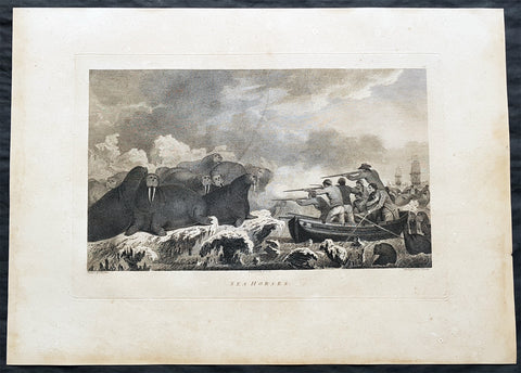
Background: Tonga officially the Kingdom of Tonga, is a Polynesian sovereign state and archipelago comprising 169 islands, of which 36 are inhabited. The total surface area is about 750 square kilometres (290 sq mi) scattered over 700,000 square kilometres (270,000 sq mi) of the southern Pacific Ocean. It has a population of 107,122 people, of whom 70% reside on the main island of Tongatapu.The Tongan people first encountered Europeans in 1616 when the Dutch vessel Eendracht, captained by Willem Schouten, made a short visit to trade. Later came other Dutch explorers, including Jacob Le Maire (who called on the northern island of Niuatoputapu); and in 1643 Abel Tasman (who visited Tongatapu and Haapai).Later noteworthy European visitors included James Cook (Royal Navy) in 1773, 1774, and 1777; Alessandro Malaspina (Spanish Navy) in 1793; the first London missionaries in 1797; and the Wesleyan Methodist Reverend Walter Lawry in 1822.Tonga became known in the West as the Friendly Islands because of the congenial reception accorded to Captain James Cook on his first visit in 1773. He arrived at the time of the inasi festival, the yearly donation of the First Fruits to the Tui Tonga (the islands paramount chief) and so received an invitation to the festivities. According to the writer William Mariner, the chiefs wanted to kill Cook during the gathering but could not agree on a plan.Mu a is a small town in the Hahake (eastern) district on the island of Tongatapu, and it was for centuries the ancient capital of Tonga. It is divided in the villages Lapaha and Tatakamotonga, is close to Talasiu and famous for the ancient langi (royal burial tombs).Mua was at one time the center of Lapita culture in Tonga (about 2,000 years ago) and later (twelfth to sixteenth century CE) the capital of the Tuʻi Tonga Empire. After the disintegration of the empire it remained the capital of the Tui Tonga (Tonga kings), up to the nineteenth century, but was rather a spiritual centre and no longer a source of political power.The Tui Tonga and his retinue stayed in Lapaha, his residence being Olotele and Ahofakasiu, while Takuilau was for his wives. Subchiefs and servants on the other hand lived in Tatakamotonga.When, around 1470, the Tui Tonga line started to lose power to the Tui Ha atakalaua, and another century later to the Tu i Kanokupolu, chiefs belonging to these lines were not welcome in Mu a, and had to stay on the low-lying coastal areas, separated from the real chiefs (i.e. those belonging to the Tu i Tonga) by the Hala Fonuamoa (dry land road). The former became known as the kauhalalalo (low road people) and the latter as the kauhala uta (inland road people), which nowadays are still two important moieties in Tonga.Whatever political power the Tu i Tonga yielded to their rivals, they gained in spiritual power, and as a kind of high priest they were perhaps even more awesome than as kings. When a Tu i Tonga died he was buried in one of the huge tomb hills, known as langi, of which there are still at least two dozen in Lapaha. The Tu i Haʻatakalaua were also buried in such tombs, but they are called fale instead.The langi are big, artificial hills surrounded by huge slabs of coral rock, usually in three or more tiered layers. These slabs were quarried from several places along the coast of Tongatapu or neighbouring minor islands. The waves of the sea made them over the centuries, by compacting coral sand into layers of 10 to 20 centimetres (3.9 to 7.9 inches) thick. They were only to be dug out and then transported by boat to the building site. Nevertheless, the accuracy by which the slabs were cut to shape so that they fit along each other with barely any space to spare is remarkable.One of the best-preserved langi is the Paepae-o-Tele a, which is even more remarkable as the slabs along the corner really have an L shape.The story that the slabs were moved by magic means from Uvea to Tonga is just a myth. Uvea is volcanic and has not got the proper geology. This fact has always been known, as shown, for example by a stanza of the poem named Laveofo from around the 18th century by Tufui.Captain James King FRS 1750 – 1784 was an officer of the Royal Navy. He served under James Cook on his last voyage around the world, specialising in taking important astronomical readings using a sextant. After Cook died he helped lead the ships on the remainder of their course, also completing Cooks account of the voyage. He continued his career in the Navy, reaching the rank of post-captain, commanding several ships and serving in the American War of Independence.King joined HMS Resolution as second lieutenant, sharing the duties of astronomer with Cook, taking astronomical observations on board by sextant and with Larcum Kendals timekeeper K1, to establish the Resolutions position at sea and on shore by sextant or by astronomical quadrant to establish the geographical position of salient points during the course of Cooks surveys. Thus Kings geographical positions were an important contribution to the accuracy of the various surveys carried out during the voyage and his use of the early chronometers helped prove their use at sea for calculation of Longitude. .Following the death of Cook, King remained in the Resolution but on the death of Charles Clerke, Cooks successor, King was appointed to command HMS Discovery, the Resolutions consort, remaining in her for the rest of the voyage. After his return to England King was very much involved in the publication of the official account of Cooks third voyage, writing the third volume at Woodstock, near Oxford, where his brother Thomas was rector of St Mary Magdalene. But shortly after his return King was promoted Post-captain and appointed commander of HMS Crocodile in the English Channel.John Webber RA 1751 – 1793 was an English artist who accompanied Captain Cook on his third Pacific expedition. He is best known for his images of Australasia, Hawaii and Alaska.Webber was born in London, educated in Bern and studied painting at Paris.His father was Abraham Wäber, a Swiss sculptor who had moved to London, and changed his name to Webber before marrying a Mrs Mary Quant in 1744.Webber served as official artist on James Cooks third voyage of discovery around the Pacific (1776–80) aboard HMS Resolution. At Adventure Bay in January 1777 he did drawings of A Man of Van Diemens Land and A Woman of Van Diemens Land. He also did many drawings of scenes in New Zealand and the South Sea islands. On this voyage, during which Cook lost his life in a fight in Hawaii, Webber became the first European artist to make contact with Hawaii, then called the Sandwich Islands. He made numerous watercolor landscapes of the islands of Kauai and Hawaii, and also portrayed many of the Hawaiian people.In April 1778, Captain Cooks ships Resolution and Discovery anchored at Ship Cove, now known as Nootka Sound, Vancouver Island, Canada to refit. The crew took observations and recorded encounters with the local people. Webber made watercolour landscapes including Resolution and Discovery in Ship Cove, 1778. His drawings and paintings were engraved for British Admiraltys account of the expedition, which was published in 1784.Back in England in 1780 Webber exhibited around 50 works at Royal Academy exhibitions between 1784 and 1792, and was elected an associate of the Royal Academy in 1785 and R.A. in 1791. Most of his work were landscapes. Sometimes figures were included as in A Party from H.M.S. Resolution shooting sea horses, which was shown at the academy in 1784, and his The Death of Captain Cook became well known through an engraving of it. Another version of this picture is in the William Dixson gallery at Sydney