Welcome to Classical Images!
Description:This fine, original copper-plate engraved antique map of the Coastal city & region of Acapulco, Mexico - with legend to various places of interest - by Jacques Nicolas Bellin in 1752 was published in Antoine François Prevosts 15 volumes of Histoire Generale des Voyages written by Prevost & other authors between 1746-1790.Acapulco de Juárez commonly called Acapulco, is a city, municipality and major seaport in the state of Guerrero on the Pacific coast of Mexico, 380 kilometres (240 mi) south of Mexico City. Acapulco is located on a deep, semicircular bay and has been a port since the early colonial period of Mexico\'s history.There are two stories about how Acapulco bay was discovered by Europeans. The first states that two years after the Spanish conquest of the Aztec Empire, Hernán Cortés sent explorers west to find gold. The explorers had subdued this area after 1523, and Captain Saavedra Cerón was authorized by Cortés to found a settlement here. The other states that the bay was discovered on December 13, 1526 by a small ship named the El Tepache Santiago captained by Santiago Guevara. The first encomendero was established in 1525 at Cacahuatepec, which is part of the modern Acapulco municipality. In 1531, a number of Spaniards, most notably Juan Rodriguez de Villafuerte, left the Oaxaca coast and founded the village of Villafuerte where the city of Acapulco now stands. Villafuerte was unable to subdue the local native peoples, and this eventually resulted in the Yopa Rebellion in the region of Cuautepec. Hernán Cortés was obligated to send Vasco Porcayo to negotiate with the indigenous people giving concessions. The province of Acapulco became the encomendero of Rodriguez de Villafuerte who received taxes in the form of cocoa, cotton and cornCortés established Acapulco as a major port by the early 1530s, with the first major road between Mexico City and the port constructed by 1531. The wharf, named Marqués, was constructed by 1533 between Bruja Point and Diamond Point. Soon after, the area was made an \"alcadia\" (major province or town).Spanish trade in the Far East would give Acapulco a prominent position in the economy of New Spain. Galleons started arriving here from Asia by 1550, and in that year thirty Spanish families were sent to live here from Mexico City to have a permanent base of European residents. Acapulco would become the second most important port, after Veracruz, due to its direct trade with the Philippines. This trade would focus on the yearly Manila-Acapulco Galleon trade, which was the nexus of all kinds of communications between New Spain, Europe and Asia. In 1573, the port was granted the monopoly of the Manila tradeThe galleon trade made its yearly run from the mid-16th century until the early 19th. The luxury items it brought to New Spain attracted the attention of English and Dutch pirates, such as Francis Drake, Henry Morgan and Thomas Cavendish, who called it \"The Black Ship.\" A Dutch fleet invaded Acapulco in 1615, destroying much of the town before being driven off. The Fort of San Diego was built the following year to protect the port and the cargo of arriving ships. The fort was destroyed by an earthquake in 1776 and was rebuilt between 1778 and 1783. At the beginning of the 19th century, King Charles IV declared Acapulco a Ciudad Official and it became an essential part of the Spanish Crown. However, not long after, the Mexican War of Independence began. In 1810, José María Morelos y Pavón attacked and burnt down the city, after he defeated royalist commander Francisco Parés at the Battle of Tres Palos. The independence of Mexico in 1821 ended the run of the Manila Galleon. Acapulco\'s importance as a port recovered during the California Gold Rush in the mid-19th-century, with ships going to and coming from Panama stopping here. This city was the besieged on 19 April 1854 by Antonio López de Santa Anna after Guerrero\'s leadership had rebelled by issuing the Plan de Ayutla. After an unsuccessful week of fighting, Santa Anna retreated.
General Definitions:Paper thickness and quality: - Heavy and stablePaper color : - off whiteAge of map color: - EarlyColors used: - Green, Yellow, General color appearance: - AuthenticPaper size: - 10in x 7 1/2in (255m x 190mm)Plate size: - 8n x 6in (205mm x 155mm)Margins: - Min 1/2in (12mm)
Imperfections:Margins: - NonePlate area: - NoneVerso: - None
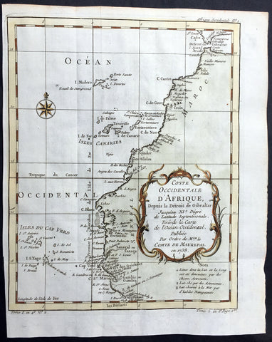
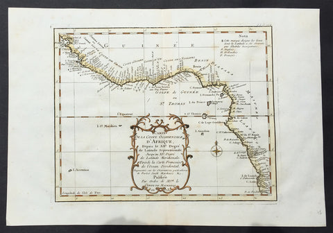
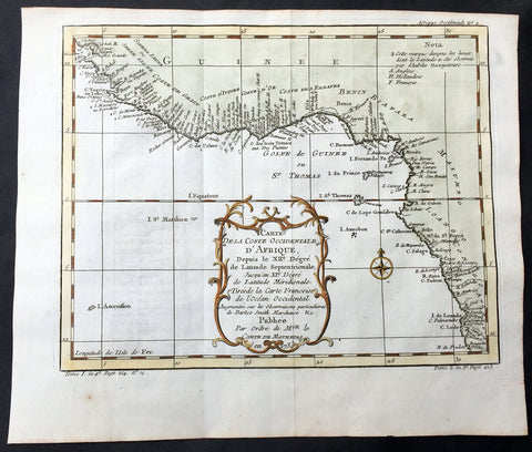
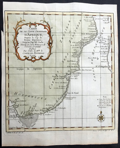
Background: One of Antoine Francois Prevosts monumental undertakings was his history of exploration & discovery in 15 volumes titledHistoire Générale des Voyages written between 1746-1759 and was extended to 20 volumes after his death by various authors.The 20 volumes cover the early explorations & discoveries on 3 continents: Africa (v. 1-5), Asia (v. 5-11), and America (v. 12-15) with material on the finding of the French, English, Dutch, and Portugese. A number of notable cartographers and engravers contributed to the copper plate maps and views to the 20 volumes including Nicolas Bellin, Jan Schley, Chedel, Franc Aveline, Fessard, and many others.The African volumes cover primarily coastal countries of West, Southern, and Eastern Africa, plus the Congo, Madagascar, Arabia and the Persian Gulf areas. The Asian volumes cover China, Korea, Tibet, Japan, Philippines, and countries bordering the Indian Ocean. Volume 11 includes Australia and Antarctica. Volumes 12-15 cover voyages and discoveries in America, including the East Indies, South, Central and North America.Volumes 16-20 include supplement volumes & tables along with continuation of voyages and discoveries in Russia, Northern Europe, America, Asia & Australia.