
Jacques Nicholas Bellin (1703 - 1772)
Profile :
A French hydrographer, geographer, and member of the French intellectual group called the philosophes.
Bellin was born in Paris. He was hydrographer of France's hydrographic office, member of the Académie de Marine and of the Royal Society of London. Over a 50-year career, he produced a large number of maps of particular interest to the Ministère de la Marine. His maps of Canada and of French territories in North America (New France, Acadia, Louisiana) are particularly valuable. He died at Versailles.
In 1721, at age 18, he was appointed hydrographer (chief cartographer) to the French Navy. In August 1741, he became the first Ingénieur de la Marine of the Depot des cartes et plans de la Marine (the French Hydrographical Office) and was named Official Hydrographer of the French King.
During his reign the Depot came out with prodigious amount of charts and maps among which was a large folio format sea-charts of France, the Neptune Francois. He also produced a number of sea-atlases of the world, e.g., the Atlas Maritime and the Hydrographie Francaise. These gained fame, distinction and respect all over Europe and were republished throughout the 18th and even in the succeeding century.
Bellin also came out with smaller format maps such as the 1764 Petit Atlas Maritime (5 vols.) containing 580 finely detailed charts.
Bellin set a very high standard of workmanship and accuracy thus gaining for France a leading role in European cartography and geography. Many of his maps were copied by other mapmakers of Europe
He was one of the Encyclopédistes, a group of 18th century intellectuals in France who compiled the 35-volume Encyclopédie which was edited by Denis Diderot and Jean le Rond d'Alembert. Bellin contributed 994 articles.
The Encyclopédistes, were part of the group called philosophes among whose members were the great minds of the Age of Enlightenment, e.g., Montesquieu, Voltaire, Rousseau, Baron d'Holbach.
Bellin contributed a number of maps to 15-vol. Histoire Generale des Voyages of Antoine François Prévost or simply known l'Abbe Prevost. One of these maps led to a geographical blunder whose impact reverberates to this day. This was the map of the Philippines which Bellin copied from a world-famous chart produced in 1734 by the Spanish missionary to the Philippines, Fr. Pedro Murillo Velarde.
Unlike many other European mapmakers of the time who outright appropriated Murillo's map, Bellin had the intellectual integrity to fully credit Murillo as his source, an open acknowledgement shown in the title cartouche of Bellin's map which came out the same year as the original work by Murillo.
Shown in Bellin's map was an island named "Limasava", a word invented in 1667 by Spanish friar, Fr. Francisco Combés, S.J., to refer to the way station of the Armada de Molucca under the command of the Portuguese captain-general Fernao de Magalhaes during its navigation in Philippine waters. Combés, who had not read a single eyewitness account of the Magellan expedition relied on two sources, the hopelessly garbled Italian translation of the Antonio Pigafetta account by Giovanni Battista Ramusio and the secondhand account by Antonio de Herrera y Tordesillas. Ramusio wrote the fleet anchored in March–April 1521 in Butuan in Mindanao, and from there sailed for Cebu with a brief stopover at "Messana". In the authentic Pigafetta account, the port was an isle named Mazzaua while the stopover isle was named Gatighan. Antonio de Herrera y Tordesillas gave a faithful narration of the Mazzaua anchorage.
Combés disregarded de Herrera's version and adopted Ramusio's. He wrote that Magellan's fleet had anchored at Butuan and from their sailed for Cebu making a stop at a way station he named Limasaua.
Five years earlier than Combés, Fr. Francisco Colín wrote the Armada moored at Butuan from March–April 1521 where Magellan and his men together with the natives celebrated an Easter Sunday mass on 31 March 1521. From Butuan the fleet sailed for Cebu making a brief stop at a way station he called "Dimasaua", an invented word meaning "this is not the Mazagua of Antonio de Herrera where supposedly an Easter Sunday mass was held which I already said happened in Butuan."
This episode was projected in the 1734 map made by Murillo who used Combés name, "Limassava" not "Dimasaua" which map Bellin copied
In 1789, Augustinian Carlo Amoretti, Italian Encyclopedist and librarian of Biblioteca Ambrosiana in Milan, discovered the authentic Italian manuscript of Antonio Pigafetta among the scattered holdings of the library. Here it came out that the port of March–April 1521 was not Butuan but Mazaua. Amoretti, who himself had not read any of five eyewitness reports of the incident including two French versions of Pigafetta's account, asserted in a footnote that Mazaua was probably the isle named Limasava in Bellin's map, thus interchanging the real port of Mazaua with the way station Gatighan.
Largely with the appearance of the eyewitness account of Ginés de Mafra, the only seaman in Magellan's fleet to return to Mazaua, whose testimony reveals a concrete, measurable description of Mazaua, the skein starting from the garbled version of Pigafetta by Ramusio to the mishandling by Combés to Bellin and finally to Amoretti has been unraveled: Pigafetta's Gatighan is Bellin's Limasava.
Published Works:
- Hydrographie française (1753)
- Carte de l'Amérique septentrionale (Map of Northern America) (1755)
- Le petit Atlas François. Recueil de Cartes et Plans des quatre parties du Monde (1758)
- Petit Atlas Maritime (1764)
- Nouvelle méthode pour apprendre la géographie (1769)
Jacques Nicholas Bellin (67)

1739 Bellin Original Antique Map of SW Africa The Cape to Angola - Hottentots
- Title: Carte Occidentale D Afrique...1739
- Date: 1739
- Condition : (A+) Fine Condition
- Ref: 25563
- Size: 14in x 10in (355mm x 255mm)
Description:
This fine large, original copper-plate engraved antique map of central and south western coastline of Africa - from the cape to northern Angola - by Jacques Nicolas Bellin in 1739 was published in Antoine François Prevosts 15 volumes of Histoire Generale des Voyages written by Prevost & other authors between 1746-1790.
General Definitions:
Paper thickness and quality: - Heavy and stable
Paper color : - off white
Age of map color: - Early
Colors used: - Green, Yellow,
General color appearance: - Authentic
Paper size: - 11 1/2in x 11in (295mm x 280mm)
Plate size: - 11in x 9in (280mm x 230mm)
Margins: - Min 1/2in (6mm)
Imperfections:
Margins: - None
Plate area: - None
Verso: - None
Background:
One of Antoine Francois Prevosts monumental undertakings was his history of exploration & discovery in 15 volumes titledHistoire Générale des Voyages written between 1746-1759 and was extended to 20 volumes after his death by various authors.
The 20 volumes cover the early explorations & discoveries on 3 continents: Africa (v. 1-5), Asia (v. 5-11), and America (v. 12-15) with material on the finding of the French, English, Dutch, and Portugese.
A number of notable cartographers and engravers contributed to the copper plate maps and views to the 20 volumes including Nicolas Bellin, Jan Schley, Chedel, Franc Aveline, Fessard, and many others.
The African volumes cover primarily coastal countries of West, Southern, and Eastern Africa, plus the Congo, Madagascar, Arabia and the Persian Gulf areas.
The Asian volumes cover China, Korea, Tibet, Japan, Philippines, and countries bordering the Indian Ocean.
Volume 11 includes Australia and Antarctica.
Volumes 12-15 cover voyages and discoveries in America, including the East Indies, South, Central and North America.
Volumes 16-20 include supplement volumes & tables along with continuation of voyages and discoveries in Russia, Northern Europe, America, Asia & Australia.

1740 Bellin Antique Coastal Map of South East Africa - South Africa to Zanzibar
- Title : Carte de la Coste Orientale D Afrique...1740
- Date : 1740
- Size: 12in x 9 1/2in (305mm x 240mm)
- Ref #: 92509
- Condition: (A+) Fine Condition
Description:
This fine large, original copper-plate engraved antique map of South and Eastern Coast of Africa from South Africa to Zanzibar by Jacques Nicolas Bellin in 1740 was published in Antoine François Prevosts 15 volumes of Histoire Generale des Voyages written by Prevost & other authors between 1746-1790.
General Condition:
Paper thickness and quality: - Heavy and stable
Paper color: - off white
Age of map color: - Early
Colors used: - Red, green, yellow
General color appearance: - Authentic
Paper size: - 12in x 9 1/2in (305mm x 240mm)
Plate size: - 10in x 8in (255mm x 205mm)
Margins: - Min 1/2in (12mm)
Imperfections:
Margins: - None
Plate area: - Folds as issued
Verso: - None
Background:
One of Antoine Francois Prevosts monumental undertakings was his history of exploration & discovery in 15 volumes titledHistoire Générale des Voyages written between 1746-1759 and was extended to 20 volumes after his death by various authors.
The 20 volumes cover the early explorations & discoveries on 3 continents: Africa (v. 1-5), Asia (v. 5-11), and America (v. 12-15) with material on the finding of the French, English, Dutch, and Portugese.
A number of notable cartographers and engravers contributed to the copper plate maps and views to the 20 volumes including Nicolas Bellin, Jan Schley, Chedel, Franc Aveline, Fessard, and many others.
The African volumes cover primarily coastal countries of West, Southern, and Eastern Africa, plus the Congo, Madagascar, Arabia and the Persian Gulf areas.
The Asian volumes cover China, Korea, Tibet, Japan, Philippines, and countries bordering the Indian Ocean.
Volume 11 includes Australia and Antarctica.
Volumes 12-15 cover voyages and discoveries in America, including the East Indies, South, Central and North America.
Volumes 16-20 include supplement volumes & tables along with continuation of voyages and discoveries in Russia, Northern Europe, America, Asia & Australia.

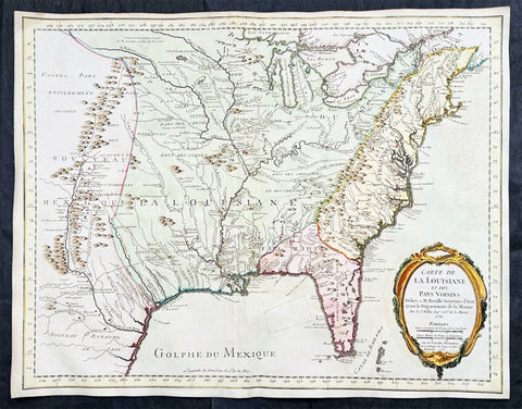
1744 Nicolas Bellin Large Important Antique Map of North America, Charlevoix
- Title : Carte De La Louisiane Cours Du Mississipi et Pais Voisions Dediee a M la Comte de Maurepas...Par N Bellin Ingenieur de la Marine, 1744
- Date : 1744
- Condition: (A+) Fine Condition
- Ref: 93108
- Size: 29in x 20in (735mm x 515mm)
Description:
This large original hand coloured copper-plate engraved antique map of North America by Nicolas Bellin, in 1744 - dated - was engraved by Guillaume Dheulland (1700-1770) & published in Pierre Francois Xavier Charlevoix book on Canada & North America Histoire et Description Generale de la Nouvelle France avec Le Journal Historique d\'un Voyage fait par Ordre du Roi dans L\'Amérique Septentrionnale
Extremely important, large and much overlooked map of North America, extending from New England, The Great Lakes to Florida and west to the Rio Grande River, New Mexico, east to Santa Fe, Taos, and the known regions of the Missouri Valley. Charlevoix map provides a remarkable overview of the regions of the future United, in the first half of the 18th Century.
The map tracks to the sources of the Mississippi River and depicts 4 of the 5 Great providing the most up to date information on the Mississippi River Basin, Ohio River and the major river systems between the Mississippi River and the Appalachians.
The map is one of Bellins earliest of North America and was published map the regions described in Charlevoix Histoire et description générale de la Nouvelle France and was also compiled in part from the Chaussegros de Lery manuscripts. The map is noteworthy for the mountain range in Michigan that did not exist, with detailed text on American Indian locations and lands and notes on French forts and other early settlements and towns.
In 1720 the Duke of Orleans sent the Jesuit scholar and explorer Pierre François-Xavier de Charlevoix to America to record events in New France and Louisiana and determine the best route to the Pacific Ocean. Charlevoix gathered geographic information from fur traders in Quebec and travelled through the Great Lakes and down the Mississippi River. After he returned to France, Charlevoix published his views on North America, which has become one of the most important works on North America prior to the French & Indian, 7 years, war.
It is recorded that Thomas Jefferson owned a copy of Charlevoix book and recommended it, along with the accounts of Hennepin and Lahontan, as a particularly useful for detail in the largely unexplored regions of North America. He referred to Charlevoix book & Bellins map as he developed his own ideas of Louisiana and the Northwest.
General Definitions:
Paper thickness and quality: - Heavy and stable
Paper color : - off white
Age of map color: -
Colors used: -
General color appearance: -
Paper size: - 29in x 20in (735mm x 515mm)
Plate size: - 23in x 16 1/2in (590mm x 420mm)
Margins: - Min 1in (25mm)
Imperfections:
Margins: - Light soiling
Plate area: - None
Verso: - Light soiling
Background:
Pierre-François-Xavier de Charlevoix 1682 - 1761 was a French Jesuit priest who wrote one of the earliest descriptive accounts of North America.
Sent from France on a scientific and exploratory mission to Canada, where he had previously stayed, he traveled up the St. Lawrence River in 1720, passed through the Great Lakes, made the portage to the Mississippi River, survived shipwreck in the Gulf of Mexico, and visited the island of Santo Domingo. Returning home, he wrote Histoire de Saint-Domingue and Histoire et description générale de la Nouvelle-France the latter of much historical value.

1744 Nicolas Bellin Original Antique Map of Hudsons Bay & Surrounds, Canada
- Title : Karte Von Der Hudsons Bay Durch N Bellin..1744
- Ref #: 41156
- Size: 14in x 9 1/2in (355mm x 240mm)
- Date : 1744
- Condition: (A+) Fine Condition
Description:
This fine, original copper-plate engraved antique map of Hudsons Bay, Canada by Jacques Nicolas Bellin in 1744 was published in Antoine François Prevosts 15 volumes of Histoire Generale des Voyages written by Prevost & other authors between 1746-1790.
Hudson Bay is a large body of saltwater in northeastern Canada with a surface area of 1,230,000 km2 (470,000 sq mi). It drains a very large area, about 3,861,400 km2 (1,490,900 sq mi), that includes parts of southeastern Nunavut, Saskatchewan, Alberta, most of Manitoba, Ontario, Quebec and parts of North Dakota, South Dakota, Minnesota, and Montana. Hudson Bay\'s southern arm is called James Bay.
English explorers and colonists named Hudson Bay after Sir Henry Hudson who explored the bay beginning August 2, 1610 on his ship Discovery.:170 On his fourth voyage to North America, Hudson worked his way around Greenland\'s west coast and into the bay, mapping much of its eastern coast. Discovery became trapped in the ice over the winter, and the crew survived onshore at the southern tip of James Bay. When the ice cleared in the spring, Hudson wanted to explore the rest of the area, but the crew mutinied on June 22, 1611. They left Hudson and others adrift in a small boat. No one knows the fate of Hudson or the crew members stranded with him, but historians see no evidence that they survived for long afterwards.
In 1668, Nonsuch reached the bay and traded for beaver pelts, leading to the creation of the Hudson\'s Bay Company (HBC) which still bears the historic name. The HBC negotiated a trading monopoly from the English crown for the Hudson Bay watershed, called Rupert\'s Land. France contested this grant by sending several military expeditions to the region, but abandoned its claim in the Treaty of Utrecht (April 1713).
During this period, the Hudson\'s Bay Company built several factories (forts and trading posts) along the coast at the mouth of the major rivers (such as Fort Severn, Ontario; York Factory and Churchill, Manitoba). The strategic locations were bases for inland exploration. More importantly, they were trading posts with the indigenous peoples who came to them with furs from their trapping season. The HBC shipped the furs to Europe and continued to use some of these posts well into the 20th century.
General Definitions:
Paper thickness and quality: - Heavy and stable
Paper color : - off white
Age of map color: -
Colors used: -
General color appearance: -
Paper size: - 14in x 9 1/2in (355mm x 240mm)
Plate size: - 12in x 9in (305mm x 230mm)
Margins: - Min 1/2in (12mm)
Imperfections:
Margins: - None
Plate area: - Folds as issued
Verso: - None
Background:
One of Antoine Francois Prevosts monumental undertakings was his history of exploration & discovery in 15 volumes titledHistoire Générale des Voyages written between 1746-1759 and was extended to 20 volumes after his death by various authors.
The 20 volumes cover the early explorations & discoveries on 3 continents: Africa (v. 1-5), Asia (v. 5-11), and America (v. 12-15) with material on the finding of the French, English, Dutch, and Portugese.
A number of notable cartographers and engravers contributed to the copper plate maps and views to the 20 volumes including Nicolas Bellin, Jan Schley, Chedel, Franc Aveline, Fessard, and many others.
The African volumes cover primarily coastal countries of West, Southern, and Eastern Africa, plus the Congo, Madagascar, Arabia and the Persian Gulf areas.
The Asian volumes cover China, Korea, Tibet, Japan, Philippines, and countries bordering the Indian Ocean.
Volume 11 includes Australia and Antarctica.
Volumes 12-15 cover voyages and discoveries in America, including the East Indies, South, Central and North America.
Volumes 16-20 include supplement volumes & tables along with continuation of voyages and discoveries in Russia, Northern Europe, America, Asia & Australia.

1746 Bellin Antique Map The Course of Sangha River, Cameroon & The Congo, Africa
- Title : Cours De La Riviere De Sanaga ou Senegal
- Size: 14in x 10in (360mm x 255mm)
- Ref #: 25554
- Date : 1746
- Condition: (A+) Fine Condition
Description:
This fine large, original copper-plate engraved antique map of the course of the Sangha River flowing through Cameroon & The Congo in Central Africa by Jacques Nicolas Bellin in 1746 was published in Antoine François Prevosts 15 volumes of Histoire Generale des Voyages written by Prevost & other authors between 1746-1790.
General Definitions:
Paper thickness and quality: - Heavy and stable
Paper color : - off white
Age of map color: - Early
Colors used: - Green, Yellow,
General color appearance: - Authentic
Paper size: - 14in x 10in (360mm x 255mm)
Plate size: - 12in x 9 1/2in (305mm x 245mm)
Margins: - Min 1/2in (6mm)
Imperfections:
Margins: - None
Plate area: - Folds as issued
Verso: - None
Background:
One of Antoine Francois Prevosts monumental undertakings was his history of exploration & discovery in 15 volumes titledHistoire Générale des Voyages written between 1746-1759 and was extended to 20 volumes after his death by various authors.
The 20 volumes cover the early explorations & discoveries on 3 continents: Africa (v. 1-5), Asia (v. 5-11), and America (v. 12-15) with material on the finding of the French, English, Dutch, and Portugese.
A number of notable cartographers and engravers contributed to the copper plate maps and views to the 20 volumes including Nicolas Bellin, Jan Schley, Chedel, Franc Aveline, Fessard, and many others.
The African volumes cover primarily coastal countries of West, Southern, and Eastern Africa, plus the Congo, Madagascar, Arabia and the Persian Gulf areas.
The Asian volumes cover China, Korea, Tibet, Japan, Philippines, and countries bordering the Indian Ocean.
Volume 11 includes Australia and Antarctica.
Volumes 12-15 cover voyages and discoveries in America, including the East Indies, South, Central and North America.
Volumes 16-20 include supplement volumes & tables along with continuation of voyages and discoveries in Russia, Northern Europe, America, Asia & Australia.

1746 Bellin Antique Map The Course of Sangha River, Cameroon & The Congo, Africa
- Title : Cours De La Riviere De Sanaga ou Senegal
- Size: 14in x 10in (360mm x 255mm)
- Ref #: 21201
- Date : 1746
- Condition: (A+) Fine Condition
Description:
This fine large, original copper-plate engraved antique map of the course of the Sangha River flowing through Cameroon & The Congo in Central Africa by Jacques Nicolas Bellin in 1746 was published in Antoine François Prevosts 15 volumes of Histoire Generale des Voyages written by Prevost & other authors between 1746-1790.
General Definitions:
Paper thickness and quality: - Heavy and stable
Paper color : - off white
Age of map color: - Early
Colors used: - Green, Yellow,
General color appearance: - Authentic
Paper size: - 14in x 10in (360mm x 255mm)
Plate size: - 12in x 9 1/2in (305mm x 245mm)
Margins: - Min 1/2in (6mm)
Imperfections:
Margins: - None
Plate area: - Folds as issued
Verso: - None
Background:
One of Antoine Francois Prevosts monumental undertakings was his history of exploration & discovery in 15 volumes titledHistoire Générale des Voyages written between 1746-1759 and was extended to 20 volumes after his death by various authors.
The 20 volumes cover the early explorations & discoveries on 3 continents: Africa (v. 1-5), Asia (v. 5-11), and America (v. 12-15) with material on the finding of the French, English, Dutch, and Portugese.
A number of notable cartographers and engravers contributed to the copper plate maps and views to the 20 volumes including Nicolas Bellin, Jan Schley, Chedel, Franc Aveline, Fessard, and many others.
The African volumes cover primarily coastal countries of West, Southern, and Eastern Africa, plus the Congo, Madagascar, Arabia and the Persian Gulf areas.
The Asian volumes cover China, Korea, Tibet, Japan, Philippines, and countries bordering the Indian Ocean.
Volume 11 includes Australia and Antarctica.
Volumes 12-15 cover voyages and discoveries in America, including the East Indies, South, Central and North America.
Volumes 16-20 include supplement volumes & tables along with continuation of voyages and discoveries in Russia, Northern Europe, America, Asia & Australia.
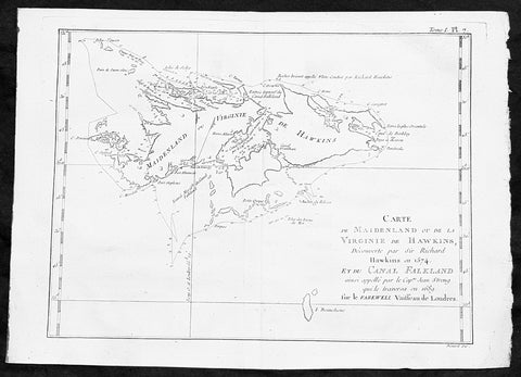
1747 Bellin Antique Map of the Falkland or Maldives Islands Argentina South America
- Title: Carte de Maidenland ou de la Virginie de Hawkins...Richard Hawkins 1574...Cap Jean Strong...1689
- Date: 1747
- Condition : (A+) Fine Condition
- Ref: 35488
- Size: 14in x 10in (360mm x 255mm)
Description:
This fine, original copper-plate engraved antique map of the Falkland Islands by Jacques Nicolas Bellin in 1750 was published in Antoine François Prevosts 15 volumes of Histoire Generale des Voyages written by Prevost & other authors between 1746-1790.
Although Fuegians from Patagonia may have visited the Falkland Islands in prehistoric times, the islands were uninhabited at the time of their discovery by Europeans. Claims of discovery date back to the 16th century, but no consensus exists on whether early explorers discovered the Falklands or other islands in the South Atlantic. The first recorded landing on the islands is attributed to English captain John Strong, who, en route to Peru\'s and Chile\'s littoral in 1690, discovered the Falkland Sound and noted the islands\' water and game.
The Falklands remained uninhabited until the 1764 establishment of Port Louis on East Falkland by French captain Louis Antoine de Bougainville, and the 1766 foundation of Port Egmont on Saunders Island by British captain John MacBride. Whether or not the settlements were aware of each other\'s existence is debated by historians. In 1766, France surrendered its claim on the Falklands to Spain, which renamed the French colony Puerto Soledad the following year. Problems began when Spain discovered and captured Port Egmont in 1770. War was narrowly avoided by its restitution to Britain in 1771.
Both the British and Spanish settlements coexisted in the archipelago until 1774, when Britain\'s new economic and strategic considerations led it to voluntarily withdraw from the islands, leaving a plaque claiming the Falklands for King George III. Spain\'s Viceroyalty of the Río de la Plata became the only governmental presence in the territory. West Falkland was left abandoned, and Puerto Soledad became mostly a prison camp.Amid the British invasions of the Río de la Plata during the Napoleonic Wars in Europe, the islands\' governor evacuated the archipelago in 1806; Spain\'s remaining colonial garrison followed suit in 1811, except for gauchos and fishermen who remained voluntarily.
General Definitions:
Paper thickness and quality: - Heavy and stable
Paper color : - off white
Age of map color: -
Colors used: -
General color appearance: -
Paper size: - 14in x 10in (355mm x 255mm)
Plate size: - 12in x 8in (305mm x 205mm)
Margins: - Min 1/2in (12mm)
Imperfections:
Margins: - None
Plate area: - None
Verso: - None
Background:
One of Antoine Francois Prevosts monumental undertakings was his history of exploration & discovery in 15 volumes titledHistoire Générale des Voyages written between 1746-1759 and was extended to 20 volumes after his death by various authors.
The 20 volumes cover the early explorations & discoveries on 3 continents: Africa (v. 1-5), Asia (v. 5-11), and America (v. 12-15) with material on the finding of the French, English, Dutch, and Portugese.
A number of notable cartographers and engravers contributed to the copper plate maps and views to the 20 volumes including Nicolas Bellin, Jan Schley, Chedel, Franc Aveline, Fessard, and many others.
The African volumes cover primarily coastal countries of West, Southern, and Eastern Africa, plus the Congo, Madagascar, Arabia and the Persian Gulf areas.
The Asian volumes cover China, Korea, Tibet, Japan, Philippines, and countries bordering the Indian Ocean.
Volume 11 includes Australia and Antarctica.
Volumes 12-15 cover voyages and discoveries in America, including the East Indies, South, Central and North America.
Volumes 16-20 include supplement volumes & tables along with continuation of voyages and discoveries in Russia, Northern Europe, America, Asia & Australia.
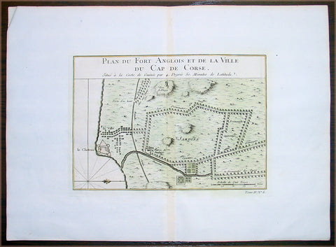
1747 Bellin Antique Map Plan Cape Coast Castle in Ghana West Africa - Slavery
- Title: Plan Du Fort Anglois et de la Ville du Cap De Corse
- Date: 1747
- Condition : (A+) Fine Condition
- Ref: 25657
- Size: 11 1/2in x 11in (295mm x 280mm)
Description:
This beautifully hand coloured original antique map a plan of the Cape Coast Castle - the notorious Slave Castle - situated in the West African country of Ghana was published in 1747 by Jacques Nicolas Bellin for Antoine-François Prevosts 20 volume edition of L`Histoire Generale des Voyages published by Pierre de Hondt, The Hague between 1747 & 1785.
Background: Cape Coast Castle is one of a number of "slave castles", fortifications in Ghana built by Swedish traders, originally for trade in timber and gold, later used in the trans-Atlantic slave trade. Other Ghanaian slave castles include the Portuguese foundation of Elmina Castle (later Dutch) and Fort Christiansborg. They were used to hold slaves before they were loaded onto ships and traded in the Americas and the Caribbean. This “gate of no return” was the last stop before crossing the great Atlantic Ocean (Ref: Tooley; M&B)
General Description:
Paper thickness and quality: - Heavy and stable
Paper color: - off white
Age of map color: - Early
Colors used: - Red, green, yellow
General color appearance: - Authentic
Paper size: - 14in x 10in (380mm x 255mm)
Plate size: - 9in x 6 1/2in (230mm x 165mm)
Margins: - Min 1in (25mm)
Imperfections:
Margins: - None
Plate area: - None
Verso: - None
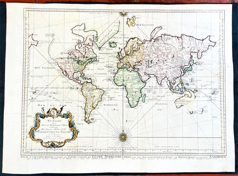
1748 (1770) Nicolas Bellin Large Antique World Map updated by Capt. Cook
Antique Map
- Title : Essay d une Carte Reduite Contenant les parties connuees Du Globe Terrestre...Par N Bellin...1748
- Size: 30 1/2in x 22in (785mm x 560mm)
- Condition: (A+) Fine Condition
- Date : 1748 (1770)
- Ref #: 93353
Description:
This large original copper-plate engraved hand coloured antique World Map, on Mercators Projection, is dated 1748 by Nicolas Bellin, updated showing the discoveries of Captain James Cook in his first voyage of Discovery from 1769-1772.
General Definitions:
Paper thickness and quality: - Heavy and stable
Paper color : - off white
Age of map color: - Early
Colors used: - Yellow, green, blue, orange
General color appearance: - Authentic
Paper size: - 30 1/2in x 22in (785mm x 560mm)
Plate size: - 28 1/2in x 20 1/2in (725mm x 520mm)
Margins: - Min 1in (25mm)
Imperfections:
Margins: - Folds as issued
Plate area: - Folds as issued
Verso: - Folds as issued
Background:
The map presents the entire world on Mercator Projection based on a Paris (LIsle de Fer) meridian, exhibiting post-Cook geography throughout, but most specifically in the Pacific and along the northwest coast of America.
North America to the west of the Mississippi is vaguely rendered according to 16th century expeditions into the region by Coronado, La Salle, De Soto, and others.
Bellin identifies the semi-mythical civilizations of Quivira and Teguayo, both associated with legends of the Seven Cities of Gold, in what is modern day Utah, California, and Nevada. Along the western coast the strait discovered by Martin Aguilar is noted. Further north still the River of the West (Fl. de lOuest) extends from the west coast to the Lake of the Woods (Lac de Bois) and thence via additional waterways to the Great Lakes and the Atlantic. The River of the West appeared in many 18th century maps of the Americas and is reflective of French hopes for a water route from their colonies in Canada and Louisiana to the Pacific. Still further north the coastline becomes extremely vague, in places vanishing altogether. The Aleutians are vaguely rendered according to various sightings by Vitus Jonassen Bering and Aleksei Chirikov in the 1740s and identified as the Archipel de Nord.
In the Pacific, various Polynesian Island groups are noted though many are slightly or significantly misplaced. The Solomon Islands are vastly oversized referencing the early 17th claims of Quiros. The other lands discovered and erroneously mapped by Quiros in 1606 and Davis in 1686 during their search of the great southern continent are also noted. Hawaii, as yet undiscovered, is absent. New Zealand is rendered twice though is accurate in its form and position. Australia, here labeled Nouvelle Holland, has part of its southern coastline ghosted in and Van Diemens Land (Tasmania) is attached to the mainland. The southern coast of New Guinea is similarly ghosted in, suggesting its unexplored state.
It is of interest that there is a common misconception regarding this map that suggests the first edition was dated 1748. There are editions with a printed date of 1748, but these are actually later editions. The 1748 date is a printing error in which 8 and 4 are transposed, the actual date of publication being 1784. The first edition of this map is the 1778 example shown here. (Ref: Tooley; M&B)
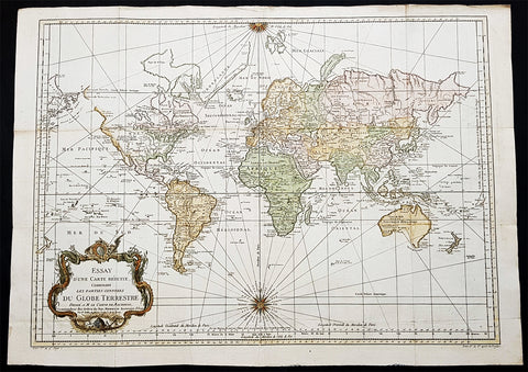
1748 J N Bellin Large Antique World Map on Mercators Projection - 27007
Antique Map
- Title : Essay d une Carte Reduite Contenant les parties connuees Du Globe Terrestre...1748
- Date : 1748
- Size: 28 1/2in x 21in (725mm x 535mm)
- Condition: (A) Very Good Condition
- Ref: 27007
Description:
This large original hand coloured copper-plate engraved antique World Map, on Mercators Projection was engraved in 1748 by Jacques Nicolas Bellin - dated in the title.
General Definitions:
Paper thickness and quality: - Heavy and stable
Paper color : - off white
Age of map color: - Early
Colors used: - Blue, yellow, green, pink
General color appearance: - Authentic
Paper size: - 28 1/2in x 21in (725mm x 535mm)
Plate size: - 26in x 20 1/2in (710mm x 520mm)
Margins: - Min 1/4in (5mm)
Imperfections:
Margins: - Bottom left margin extended from plate -mark
Plate area: - Folds as issued
Verso: - Folds as issued
Background:
First edition of Bellins large mid-18th century world map, published in Paris. This map pre-dates the major world discoveries of the late 18th century including the North West coast of America, the Sandwich Islands, and the Voyages of Capt Cook soon to map the East Coast of Australia & NZ.
This edition is most noteworthy for its marvelous early projection of Australia and New Zealand, each with largely speculative coastlines. Australia is still attached to New Guinea and has several notes of early exploration shown. New Zealand is barely known and with only a portion of its western coastline.
No sign of Antarctica and the NW Coast of America includes the first notes of Russian exploration.
In North America Bellin identifies the semi-mythical civilizations of Quivira and Teguayo, both associated with legends of the Seven Cities of Gold, in what is modern day Utah, California, and Nevada. Along the western coast the strait discovered by Martin Aguilar is noted. Further north still the River of the West (Fl. de l’Ouest) extends from the west coast to the Lake of the Woods (Lac de Bois) and thence via additional waterways to the Great Lakes and the Atlantic. The River of the West appeared in many 18th century maps of the Americas and is reflective of French hopes for a water route from their colonies in Canada and Louisiana to the Pacific. Still further north the coastline becomes extremely vague, in places vanishing altogether. The Aleutians are vaguely rendered according to various sightings by Vitus Jonassen Bering and Aleksei Chirikov in the 1740s and identified as the “Archipel de Nord”.
In the Pacific, various Polynesian Island groups are noted though many are slightly or significantly misplaced. The Solomon Islands are vastly oversized referencing the early 17th claims of Quiros. The other lands discovered and erroneously mapped by Quiros in 1606 and Davis in 1686 during their search of the great southern continent are also noted. Hawaii, as yet undiscovered, is absent. New Zealand is rendered twice though is accurate in its form and position. Australia, here labelled “Nouvelle Holland”, has part of its southern coastline ghosted in and Van Diemen’s Land (Tasmania) is attached to the mainland. The southern coast of New Guinea is similarly ghosted in, suggesting its unexplored state. (Ref: Tooley; M&B)
1750 (1755) Nicolas Bellin Very Scarce Large Antique Map of North America
Antique Map
- Title : Carte de La Louisiane et Des Pays Voisins Dediee a M. Rouille Secretairr 'd Etat ayant le Departement de la Marine . . . 1750 . . . Sur de Nouvelle Observations on a corrigee les Lacs, et leurs Enviorns. 1755.
- Date : 1750 (1755)
- Size: 25in x 19 1/2in (635mm x 495mm)
- Condition: (A) Very Good Condition
- Ref: 35661
Description:
This large original very scarce hand coloured copper-plate engraved antique map of North America by Nicolas Bellin, in 1750 - dated - and updated in 1755, was published as a single map by Nicolas Bellin in Paris.
Extremely important, large and scarce 1755 map of North America issued at the outbreak of the French and Indian War (1754 - 1763). Centered on the vast Mississippi Valley, the map covers from the Rio Grande to the Atlantic Seaboard and from Lake Superior to the Florida Keys. While first issued in 1750, the present map has been updated considerably to represent French, English, and Spanish claims at the outbreak of the French and Indian War. Most of the most important battle sites are forts are noted, including Fort Duquesne, Fort Necessity, Fr. Le Boeuf, Fort Presqu'Isle, and Fort St. Frederic, among others.
General Definitions:
Paper thickness and quality: - Heavy and stable
Paper color : - off white
Age of map color: - Early & later
Colors used: - Green, yellow, pink
General color appearance: - Authentic
Paper size: - 25in x 19 1/2in (635mm x 495mm)
Plate size: - 25in x 19 1/2in (635mm x 495mm)
Margins: - Min 1/2in (12mm)
Imperfections:
Margins: - None
Plate area: - Small professional restoration in GOM
Verso: - None
Background:
The map presents the much of the modern United States as the French understood it at the outbreak of the war. Spanish territory is red, English territory is yellow, and French territory is green. The British are here restricted to the coastal lands east of the Appalachian Mountains, and bounded on the south by the Altamaha River, which forms the boundary with Spanish Florida. French Territorial claims are expansive, encompassing roughly 2/3rds of the land and controlling the most valuable waterways, including the Great Lakes, the Ohio, and the Mississippi. Forts, mission settlements, mines, and trading posts dot the Mississippi Valley, but in truth, most of these were, by this time, only loosely manned or altogether abandoned - hardly an argument for effective occupation.
This map features a wealth of cartographic information drawn in part from the Guilaume de L'Isle map of 1718, but has been expanded considerably with new information from the the Chaussegros de Lery manuscripts and Pierre-Francois-Xavier de Charlevoix s Histoire et description generale de la Nouvelle France. Of note is the curious mountain range running through Michigan.
The inclusion of Fort Necessity is significant, as it suggests this map was issued just months after the construction of the fort and George Washington's disastrous defeat there. It underscores how quickly information moved - even through the outback of the New World and active war. For this map to have been made, news of the events, as well as cartographic reconnaissance, would have had to move rapidly from Fort Duquesne, down the Ohio River, then down the full length of the Mississippi, then across the Atlantic to Paris. There Bellin would have had to study the work, reconcile it with his older maps, update and re-engrave them accordingly, and then get the map to the presses for distribution. The whole is a remarkable accomplishment, but may explain somewhat this maps scarcity, as in a short time, much of the data he would be irreverent.
The map is dedicated to Antoine-Louis Rouillé, comte de Jouy (1689 - 1761). Rouillé replaced Jean-Frédéric Phélypeaux, 1st Count of Maurepas (1701 - 1781), Bellin's former patron, as Secretary of State for the Navy (Ministère de la Marine) on July 24, 1754, just in time for the French and Indian War. Bellin, who worked under the Navy Department, would have been highly motivated to engender Rouillé patronage and good well, making the dedication unsurprising.
The map was separately published in Paris, France by Jacques-Nicolas Bellin. It is dedicated to M. Rouillé. It represents the second state of the map, 1755, issued during the French and Indian War. Examples are extremely scarce. We have identified only three examples, including this map, in the last 20 years of market history. The map is further not identified in Cumming, Karpinski, Ehrenberg, or Phillips. The OCLC notes examples in 8 institutions, but upon closer inspection many of these appear to be digital resources and do not represent any actual holdings.
Please note all items auctioned are genuine, we do not sell reproductions. A Certificate of Authenticity (COA) can be issued on request.
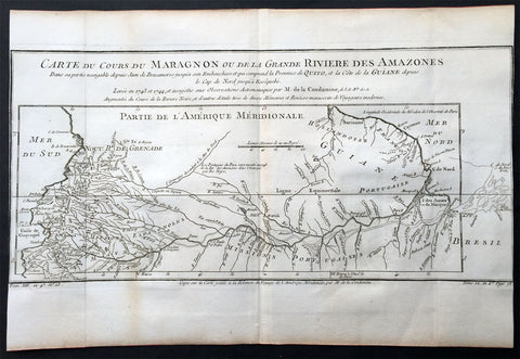
1750 Bellin & Condamine Antique Map The Course of the Amazon River South America
- Title : Carte Du Cours Du Maragnon ou De La Grande Riviere Des Amazones...1743 et 1744...par M de la Condamine
- Ref: 50686
- Size: 15in x 10in (380mm x 255mm)
- Date : 1750
- Condition: (A) Very Good Condition
Description:
This finely engraved original antique map of the course of the Amazon River - according to the discoveries of the French explorer Charles-Marie La Condamine - by Jacques Nicolas Bellin in 1750 was published in Antoine-François Prevost's monumental 20 volume edition of L`Histoire Generale des Voyages published by Pierre de Hondt, The Hague between 1747 & 1780.
Charles-Marie La Condamine (1701 - 1774) was a French mathematician and surveyor who took part in an expedition to South America to measure a degree of latitude.
La Condamine was born in Paris. He was trained for the military profession, but turned his attention to science and geographical exploration. After taking part in a scientific expedition in the Levant (1731), he became a member with Louis Godin and Pierre Bouguer of the expedition sent to Peru in 1735 to determine the length of a degree of the meridian in the neighborhood of the equator.
His associations with his principals were unhappy; the expedition was beset by many difficulties, and finally La Condamine separated from the rest and made his way from Quito down the Amazon, ultimately reaching Cayenne. His was the first scientific exploration of the Amazon. He returned to Paris in 1744 and published the results of his measurements and travels with a map of the Amazon in M' de l'Acadme des Sciences, 1745 (English translation 1745-1747). This included the first descriptions by a European of the Casiquiare canal and the curare arrow poison prepared by the Amerindians.
(Ref: Tooley; M&B)
General Description:
Paper thickness and quality: - Heavy and stable
Paper color: - off white
Age of map color: -
Colors used: -
General color appearance: -
Paper size: - 15in x 10in (380mm x 255mm)
Plate size: - 15in x 10in (380mm x 255mm)
Margins: - Min 0in (0mm)
Imperfections:
Margins: - Margins cropped to margins
Plate area: - Folds as issued
Verso: - None
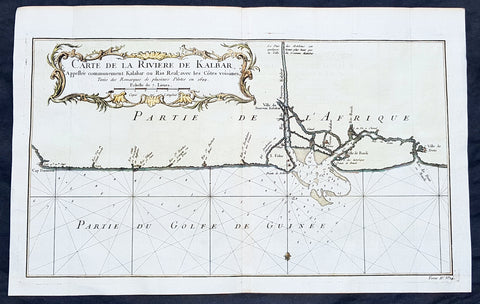
1750 Bellin Antique Map Calabar River, Calabar, Nigeria West Africa - Salve Port
- Title: Carte De la Riviere De Kalbar...Pilotes en 1699
- Date: 1750
- Condition : (A+) Fine Condition
- Ref: 25652
- Size: 16in x 10in (405mm x 255mm)
Description:
This fine large, original copper-plate engraved antique map of Calabar River Mouth, Calabar City in Nigeria, West Africa - a significant slave port of the 17th & 18th centuries - by Jacques Nicolas Bellin in 1750 was published in Antoine François Prevosts 15 volumes of Histoire Generale des Voyages written by Prevost & other authors between 1746-1790.
Detailed coastal map of Guinea coast of Western Africa, is based upon the 1699 voyage of James Barbot & John Grazilhier to New Calabar, Bandi, and Doni Rivers.
Barbot and Grazilhier each gave famous accounts of their experiences in the slave trade in the second half of the 17th Century.
General Definitions:
Paper thickness and quality: - Heavy and stable
Paper color : - off white
Age of map color: - Early
Colors used: - Green, Yellow,
General color appearance: - Authentic
Paper size: - 14in x 10in (355mm x 255mm)
Plate size: - 10 1/4in x 7 1/2in (260mm x 195mm)
Margins: - Min 1/2in (6mm)
Imperfections:
Margins: - None
Plate area: - Folds as issued
Verso: - None
Background:
One of Antoine Francois Prevosts monumental undertakings was his history of exploration & discovery in 15 volumes titledHistoire Générale des Voyages written between 1746-1759 and was extended to 20 volumes after his death by various authors.
The 20 volumes cover the early explorations & discoveries on 3 continents: Africa (v. 1-5), Asia (v. 5-11), and America (v. 12-15) with material on the finding of the French, English, Dutch, and Portugese.
A number of notable cartographers and engravers contributed to the copper plate maps and views to the 20 volumes including Nicolas Bellin, Jan Schley, Chedel, Franc Aveline, Fessard, and many others.
The African volumes cover primarily coastal countries of West, Southern, and Eastern Africa, plus the Congo, Madagascar, Arabia and the Persian Gulf areas.
The Asian volumes cover China, Korea, Tibet, Japan, Philippines, and countries bordering the Indian Ocean.
Volume 11 includes Australia and Antarctica.
Volumes 12-15 cover voyages and discoveries in America, including the East Indies, South, Central and North America.
Volumes 16-20 include supplement volumes & tables along with continuation of voyages and discoveries in Russia, Northern Europe, America, Asia & Australia.
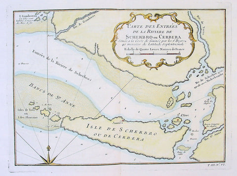
1750 Bellin Antique Map Mouth of the Sherboro River in Seirra Leone, Africa
- Title: Carte des Entrees de la Riviere de Scherbro ou Cerbera
- Date: 1750
- Condition : (A+) Fine Condition
- Ref: 25679
- Size: 14in x 10in (355mm x 255mm)
Description:
This fine large, original copper-plate engraved antique map of the mouth of the Sherboro River in Sierra Leone, Africa by Jacques Nicolas Bellin in 1750 was published in Antoine François Prevosts 15 volumes of Histoire Generale des Voyages written by Prevost & other authors between 1746-1790.
General Definitions:
Paper thickness and quality: - Heavy and stable
Paper color : - off white
Age of map color: - Early
Colors used: - Green, Yellow,
General color appearance: - Authentic
Paper size: - 14in x 10in (355mm x 255mm)
Plate size: - 10 1/4in x 7 1/2in (260mm x 195mm)
Margins: - Min 1/2in (6mm)
Imperfections:
Margins: - None
Plate area: - Folds as issued
Verso: - None
Background:
One of Antoine Francois Prevosts monumental undertakings was his history of exploration & discovery in 15 volumes titledHistoire Générale des Voyages written between 1746-1759 and was extended to 20 volumes after his death by various authors.
The 20 volumes cover the early explorations & discoveries on 3 continents: Africa (v. 1-5), Asia (v. 5-11), and America (v. 12-15) with material on the finding of the French, English, Dutch, and Portugese.
A number of notable cartographers and engravers contributed to the copper plate maps and views to the 20 volumes including Nicolas Bellin, Jan Schley, Chedel, Franc Aveline, Fessard, and many others.
The African volumes cover primarily coastal countries of West, Southern, and Eastern Africa, plus the Congo, Madagascar, Arabia and the Persian Gulf areas.
The Asian volumes cover China, Korea, Tibet, Japan, Philippines, and countries bordering the Indian Ocean.
Volume 11 includes Australia and Antarctica.
Volumes 12-15 cover voyages and discoveries in America, including the East Indies, South, Central and North America.
Volumes 16-20 include supplement volumes & tables along with continuation of voyages and discoveries in Russia, Northern Europe, America, Asia & Australia.
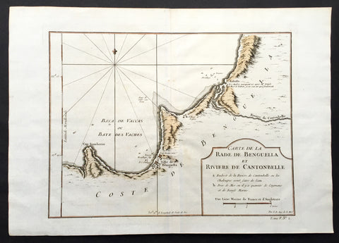
1750 Bellin Antique Map of the Benguela province of Angola, Africa
- Title: Carte de la Rade de Benguella et Riviere de Cantonbelle
- Date: 1750
- Condition : (A+) Fine Condition
- Ref: 25550
- Size: 11 1/2in x 11in (295mm x 280mm)
Description:
This fine large, original copper-plate engraved antique map of the Benguela province of Angola by Jacques Nicolas Bellin in 1750 was published in Antoine François Prevosts 15 volumes of Histoire Generale des Voyageswritten by Prevost & other authors between 1746-1790.
The Portuguese crown created the Kingdom of Benguela in 1615 to improve the conditions to develop the desired land route to Mozambique across Africa. The trading post founded here did not meet the expectations of the Portuguese in mineral resources and soil quality, so a village was only established for the slave trade, under the name of Mbaka
General Definitions:
Paper thickness and quality: - Heavy and stable
Paper color : - off white
Age of map color: - Early
Colors used: - Green, Yellow,
General color appearance: - Authentic
Paper size: - 14in x 10in (355mm x 255mm)
Plate size: - 12in x 9in (305mm x 230mm)
Margins: - Min 1/2in (6mm)
Imperfections:
Margins: - None
Plate area: - Folds as issued
Verso: - None
Background:
One of Antoine Francois Prevosts monumental undertakings was his history of exploration & discovery in 15 volumes titledHistoire Générale des Voyages written between 1746-1759 and was extended to 20 volumes after his death by various authors.
The 20 volumes cover the early explorations & discoveries on 3 continents: Africa (v. 1-5), Asia (v. 5-11), and America (v. 12-15) with material on the finding of the French, English, Dutch, and Portugese.
A number of notable cartographers and engravers contributed to the copper plate maps and views to the 20 volumes including Nicolas Bellin, Jan Schley, Chedel, Franc Aveline, Fessard, and many others.
The African volumes cover primarily coastal countries of West, Southern, and Eastern Africa, plus the Congo, Madagascar, Arabia and the Persian Gulf areas.
The Asian volumes cover China, Korea, Tibet, Japan, Philippines, and countries bordering the Indian Ocean.
Volume 11 includes Australia and Antarctica.
Volumes 12-15 cover voyages and discoveries in America, including the East Indies, South, Central and North America.
Volumes 16-20 include supplement volumes & tables along with continuation of voyages and discoveries in Russia, Northern Europe, America, Asia & Australia.
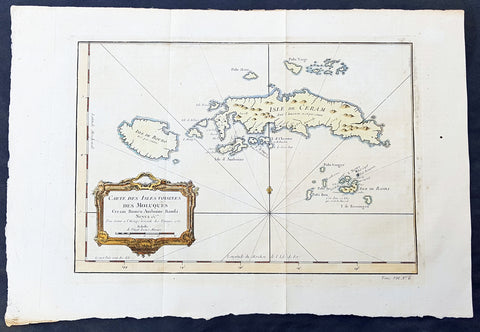
1750 Bellin Original Antique Map The Maluku or Moluccas, Spice Islands Indonesia
- Title : Carte Des Isles Voisines Des Moluques Ceram, Bouro, Amboine, Banda, Neyra....1750
- Ref #: 34099
- Size: 16in x 10 1/2in (390mm x 265mm)
- Date : 1750
- Condition: (A+) Fine Condition
Description:
This fine, original copper-plate engraved antique map of the Maluku or Moluccas Islands (Spice Islands) Indonesia by Jacques Nicolas Bellin in 1750 was published in Antoine François Prevosts 15 volumes of Histoire Generale des Voyages written by Prevost & other authors between 1746-1790.
The Maluku Islands or the Moluccas are an archipelago within Banda Sea, Indonesia. Geographically they are located east of Sulawesi, west of New Guinea, and north and east of Timor.
The islands were known as the Spice Islands due to the nutmeg, mace and cloves that were originally exclusively found there, and the presence of these sparked colonial interest from Europe in the 16th century.
The most significant lasting effects of the Portuguese colonisation was the disruption and reorganization of the Southeast Asian trade, and in eastern Indonesia—including Maluku—the introduction of Christianity. The Portuguese had conquered the city state of Malacca in the early 16th century and their influence was most strongly felt in Maluku and other parts of eastern Indonesia. After the Portuguese annexed Malacca in August 1511, one Portuguese diary noted \'it is thirty years since they became Moors - giving a sense of the competition then taking place between Islamic and European influences in the region.
Afonso de Albuquerque learned of the route to the Banda Islands and other \'Spice Islands\', and sent an exploratory expedition of three vessels under the command of António de Abreu, Simão Afonso Bisigudo and Francisco Serrão. On the return trip, Francisco Serrão was shipwrecked at Hitu island (northern Ambon) in 1512. There he established ties with the local ruler who was impressed with his martial skills. The rulers of the competing island states of Ternate and Tidore also sought Portuguese assistance and the newcomers were welcomed in the area as buyers of supplies and spices during a lull in the regional trade due to the temporary disruption of Javanese and Malay sailings to the area following the 1511 conflict in Malacca. The spice trade soon revived but the Portuguese would not be able to fully monopolize nor disrupt this trade.
Allying himself with Ternate\'s ruler, Serrão constructed a fortress on that tiny island and served as the head of a mercenary band of Portuguese seamen under the service of one of the two local feuding sultans who controlled most of the spice trade. Both Serrão and Ferdinand Magellan, however, perished before they could meet one another.
The Portuguese first landed in Ambon in 1513, but it only became the new centre for their activities in Maluku following the expulsion from Ternate. European power in the region was weak and Ternate became an expanding, fiercely Islamic and anti-European state under the rule of Sultan Baab Ullah (r. 1570–1583) and his son Sultan Said.
Following Portuguese missionary work, there have been large Christian communities in eastern Indonesia through to contemporary times, which has contributed to a sense of shared interest with Europeans, particularly among the Ambonese. By the 1560s there were 10,000 Catholics in the area, mostly on Ambon, and by the 1590s there were 50,000 to 60,000. The central and southern parts of Maluku are populated by a majority of Christians.
The Dutch arrived in 1599 and competed with the Portuguese in the area for trade.
General Definitions:
Paper thickness and quality: - Heavy and stable
Paper color : - off white
Age of map color: - Early
Colors used: - Green, yellow, red
General color appearance: - Authentic
Paper size: - 16in x 10 1/2in (390mm x 265mm)
Plate size: - 12 1/2in x 9in (320mm x 230mm)
Margins: - Min 1/2in (6mm)
Imperfections:
Margins: - Light age toning
Plate area: - Folds as issued
Verso: - None
Background:
One of Antoine Francois Prevosts monumental undertakings was his history of exploration & discovery in 15 volumes titledHistoire Générale des Voyages written between 1746-1759 and was extended to 20 volumes after his death by various authors.
The 20 volumes cover the early explorations & discoveries on 3 continents: Africa (v. 1-5), Asia (v. 5-11), and America (v. 12-15) with material on the finding of the French, English, Dutch, and Portugese.
A number of notable cartographers and engravers contributed to the copper plate maps and views to the 20 volumes including Nicolas Bellin, Jan Schley, Chedel, Franc Aveline, Fessard, and many others.
The African volumes cover primarily coastal countries of West, Southern, and Eastern Africa, plus the Congo, Madagascar, Arabia and the Persian Gulf areas.
The Asian volumes cover China, Korea, Tibet, Japan, Philippines, and countries bordering the Indian Ocean.
Volume 11 includes Australia and Antarctica.
Volumes 12-15 cover voyages and discoveries in America, including the East Indies, South, Central and North America.
Volumes 16-20 include supplement volumes & tables along with continuation of voyages and discoveries in Russia, Northern Europe, America, Asia & Australia.
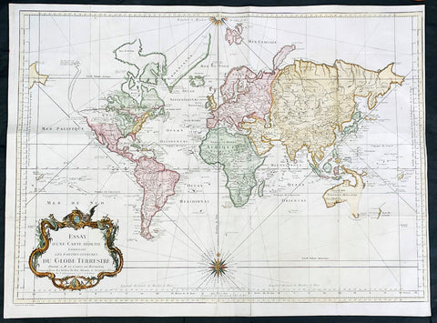
1750 J N Bellin Large Antique World Map on Mercators Projection - 27091
Antique Map
- Title : An Essay of a New and Complet Map Containing the Known Part of the Terrestial Globe by N Bellin....MDDCL
- Date : 1750
- Size: 30 1/2in x 22 1/2in (825mm x 570mm)
- Condition: (A) Very Good Condition
- Ref: 27091
Description:
This large original hand coloured copper-plate engraved antique World Map, on Mercators Projection by Jacques Nicolas Bellin was engraved by Jacobus van der Schley in 1750 - dated in the title - and was published in Dutch/English by Pierre d Hondt, publisher, operated out of the Hague.
General Definitions:
Paper thickness and quality: - Heavy and stable
Paper color : - off white
Age of map color: - Early
Colors used: - Blue, yellow, green, pink
General color appearance: - Authentic
Paper size: - 30 1/2in x 22 1/2in (825mm x 570mm)
Plate size: - 27 1/2in x 20 1/2in (700mm x 520mm)
Margins: - Min 1in (25mm)
Imperfections:
Margins: - Bottom left margin extended from plate -mark
Plate area: - Folds as issued
Verso: - Folds as issued
Background:
First edition of Bellins large mid-18th century world map, published in Paris. This map pre-dates the major world discoveries of the late 18th century including the North West coast of America, the Sandwich Islands, and the Voyages of Capt Cook soon to map the East Coast of Australia & NZ.
This edition is most noteworthy for its marvelous early projection of Australia and New Zealand, each with largely speculative coastlines. Australia is still attached to New Guinea and has several notes of early exploration shown. New Zealand is barely known and with only a portion of its western coastline.
No sign of Antarctica and the NW Coast of America includes the first notes of Russian exploration.
In North America Bellin identifies the semi-mythical civilizations of Quivira and Teguayo, both associated with legends of the Seven Cities of Gold, in what is modern day Utah, California, and Nevada. Along the western coast the strait discovered by Martin Aguilar is noted. Further north still the River of the West (Fl. de l’Ouest) extends from the west coast to the Lake of the Woods (Lac de Bois) and thence via additional waterways to the Great Lakes and the Atlantic. The River of the West appeared in many 18th century maps of the Americas and is reflective of French hopes for a water route from their colonies in Canada and Louisiana to the Pacific. Still further north the coastline becomes extremely vague, in places vanishing altogether. The Aleutians are vaguely rendered according to various sightings by Vitus Jonassen Bering and Aleksei Chirikov in the 1740s and identified as the “Archipel de Nord”.
In the Pacific, various Polynesian Island groups are noted though many are slightly or significantly misplaced. The Solomon Islands are vastly oversized referencing the early 17th claims of Quiros. The other lands discovered and erroneously mapped by Quiros in 1606 and Davis in 1686 during their search of the great southern continent are also noted. Hawaii, as yet undiscovered, is absent. New Zealand is rendered twice though is accurate in its form and position. Australia, here labelled “Nouvelle Holland”, has part of its southern coastline ghosted in and Van Diemen’s Land (Tasmania) is attached to the mainland. The southern coast of New Guinea is similarly ghosted in, suggesting its unexplored state. (Ref: Tooley; M&B)
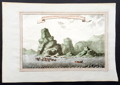
1750 Prevost & Nieuhoff Antique Print View of the Zoushan Archip. Zhejiang China
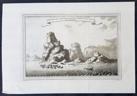
- Title: Montagne Des Cinq Tetes De Cheval Pres De Chau Cheu Fu
- Date: 1747
- Condition : (A+) Fine Condition
- Ref: 15850
- Size: 14in x 10in (355mm x 255mm)
Description:
This fine original copper-plate engraved antique print a view of the Islands of Zoushan in the in north-eastern Zhejiang Province of eastern China was engraved by Jakob van Schley - after Johannes Nieuhoff - and was published in Antoine François Prevosts 15 volumes of Histoire Generale des Voyageswritten by Prevost & other authors between 1746-1790.
Johannes Nieuhoff (1618-72) was a Dutch diplomat and adventurer, who was perhaps the most widely traveled individual of the seventeenth-century. His experiences included important expeditions to various locations in Brazil, Africa, India, Indonesia, and China. From 1655-57, Nieuhoff made an epic 2,400 trek through China, from Canton to Beijing.
During his Chinese expedition he made numerous drawings of the sites he encountered, including the port town of Chau Cheu Fu in the southern province of Guandong, which was the basis for the present print. Nieuhoff’s important written account, along with engravings of his drawings was first published as Legatio batavica ad magnum Tartariæ chamum Sungteium, modernum Sinæ imperatorem (Amsterdam, 1668). His illustrations proved to be highly influential, as they did much to spawn the genre of chinoiserie in European art and design.
General Definitions:
Paper thickness and quality: - Heavy and stable
Paper color : - off white
Age of map color: - Ewarly
Colors used: - Green, yellow, pink
General color appearance: - Authentic
Paper size: - 14in x 10in (365mm x 250mm)
Plate size: - 12in x 8in (305mm x 205mm)
Margins: - Min 1/2in (12mm)
Imperfections:
Margins: - None
Plate area: - Folds as issued
Verso: - None
Background:
One of Antoine Francois Prevosts monumental undertakings was his history of exploration & discovery in 15 volumes titledHistoire Générale des Voyages written between 1746-1759 and was extended to 20 volumes after his death by various authors.
The 20 volumes cover the early explorations & discoveries on 3 continents: Africa (v. 1-5), Asia (v. 5-11), and America (v. 12-15) with material on the finding of the French, English, Dutch, and Portugese.
A number of notable cartographers and engravers contributed to the copper plate maps and views to the 20 volumes including Nicolas Bellin, Jan Schley, Chedel, Franc Aveline, Fessard, and many others.
The African volumes cover primarily coastal countries of West, Southern, and Eastern Africa, plus the Congo, Madagascar, Arabia and the Persian Gulf areas.
The Asian volumes cover China, Korea, Tibet, Japan, Philippines, and countries bordering the Indian Ocean.
Volume 11 includes Australia and Antarctica.
Volumes 12-15 cover voyages and discoveries in America, including the East Indies, South, Central and North America.
Volumes 16-20 include supplement volumes & tables along with continuation of voyages and discoveries in Russia, Northern Europe, America, Asia & Australia.
Jakob van der Schley aka Jakob van Schley (1715 - 1779) was a Dutch draughtsman and engraver. He studied under Bernard Picart (1673-1733) whose style he subsequently copied. His main interests were engraving portraits and producing illustrations for \"La Vie de Marianne\" by Pierre Carlet de Chamblain de Marivaux (1688-1763) published in The Hague between 1735 and 1747.
He also engraved the frontispieces for a 15-volume edition of the complete works of Pierre de Brantôme (1540-1614), \"Oeuvres du seigneur de Brantôme\", published in The Hague in 1740.
He is also responsible for most of the plates in the Hague edition of Prévost\'s Histoire générale des voyages. (Ref: Tooley; M&B)
1750 Prevost & Nieuhoff Antique Print View of the Zoushan Archip. Zhejiang China
- Title: Montagne Des Cinq Tetes De Cheval Pres De Chau Cheu Fu
- Date: 1747
- Condition : (A+) Fine Condition
- Ref: 34138
- Size: 14in x 10in (355mm x 255mm)
Description:
This fine original copper-plate engraved antique print a view of the Islands of Zoushan in the in north-eastern Zhejiang Province of eastern China was engraved by Jakob van Schley - after Johannes Nieuhoff - and was published in Antoine François Prevosts 15 volumes of Histoire Generale des Voyageswritten by Prevost & other authors between 1746-1790.
Johannes Nieuhoff (1618-72) was a Dutch diplomat and adventurer, who was perhaps the most widely traveled individual of the seventeenth-century. His experiences included important expeditions to various locations in Brazil, Africa, India, Indonesia, and China. From 1655-57, Nieuhoff made an epic 2,400 trek through China, from Canton to Beijing.
During his Chinese expedition he made numerous drawings of the sites he encountered, including the port town of Chau Cheu Fu in the southern province of Guandong, which was the basis for the present print. Nieuhoff’s important written account, along with engravings of his drawings was first published as Legatio batavica ad magnum Tartariæ chamum Sungteium, modernum Sinæ imperatorem (Amsterdam, 1668). His illustrations proved to be highly influential, as they did much to spawn the genre of chinoiserie in European art and design.
General Definitions:
Paper thickness and quality: - Heavy and stable
Paper color : - off white
Age of map color: -
Colors used: -
General color appearance: -
Paper size: - 14in x 10in (365mm x 250mm)
Plate size: - 12in x 8in (305mm x 205mm)
Margins: - Min 1/2in (12mm)
Imperfections:
Margins: - None
Plate area: - Folds as issued
Verso: - None
Background:
One of Antoine Francois Prevosts monumental undertakings was his history of exploration & discovery in 15 volumes titledHistoire Générale des Voyages written between 1746-1759 and was extended to 20 volumes after his death by various authors.
The 20 volumes cover the early explorations & discoveries on 3 continents: Africa (v. 1-5), Asia (v. 5-11), and America (v. 12-15) with material on the finding of the French, English, Dutch, and Portugese.
A number of notable cartographers and engravers contributed to the copper plate maps and views to the 20 volumes including Nicolas Bellin, Jan Schley, Chedel, Franc Aveline, Fessard, and many others.
The African volumes cover primarily coastal countries of West, Southern, and Eastern Africa, plus the Congo, Madagascar, Arabia and the Persian Gulf areas.
The Asian volumes cover China, Korea, Tibet, Japan, Philippines, and countries bordering the Indian Ocean.
Volume 11 includes Australia and Antarctica.
Volumes 12-15 cover voyages and discoveries in America, including the East Indies, South, Central and North America.
Volumes 16-20 include supplement volumes & tables along with continuation of voyages and discoveries in Russia, Northern Europe, America, Asia & Australia.
Jakob van der Schley aka Jakob van Schley (1715 - 1779) was a Dutch draughtsman and engraver. He studied under Bernard Picart (1673-1733) whose style he subsequently copied. His main interests were engraving portraits and producing illustrations for \"La Vie de Marianne\" by Pierre Carlet de Chamblain de Marivaux (1688-1763) published in The Hague between 1735 and 1747.
He also engraved the frontispieces for a 15-volume edition of the complete works of Pierre de Brantôme (1540-1614), \"Oeuvres du seigneur de Brantôme\", published in The Hague in 1740.
He is also responsible for most of the plates in the Hague edition of Prévost\'s Histoire générale des voyages. (Ref: Tooley; M&B)
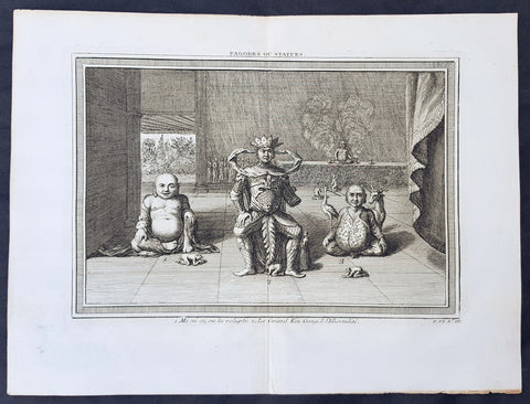
1750 Prevost Original Antique Print of 3 Statues or Deities in a Chinese Pagoda
- Title: Pagodes ou Statue
- Date: 1750
- Condition : (A+) Fine Condition
- Ref: 25951
- Size: 14in x 10in (355mm x 255mm)
Description:
This fine original copper-plate engraved antique print was engraved by Jakob van Schley and was published in Antoine François Prevosts 15 volumes of Histoire Generale des Voyages written by Prevost & other authors between 1746-1790.
Unique original print of Chinese statues in the interior of a Chinese Pagoda. The scale of the statues are illustrated by the worshipers at the feet of each statue. There is a key to each statue at the bottom of the page
No 1. Mini so, ou la Volupte - A corpulent and grinning statues representing the spirit of pleasure
No 2. Le Grand Kin Gang - An elaborately dressed imperial figure on a throne.
No 3. L immortalite - A pot-bellied, crosslegged god accompanied by a deer and a stork, the personification of immortality
In the background is a group of monks gathered next to a podium, upon which is another statue flanked by incense burners.
General Definitions:
Paper thickness and quality: - Heavy and stable
Paper color : - off white
Age of map color: -
Colors used: -
General color appearance: -
Paper size: - 14in x 10in (365mm x 250mm)
Plate size: - 12in x 8in (305mm x 205mm)
Margins: - Min 1/2in (12mm)
Imperfections:
Margins: - None
Plate area: - None
Verso: - None
Background:
One of Antoine Francois Prevosts monumental undertakings was his history of exploration & discovery in 15 volumes titledHistoire Générale des Voyages written between 1746-1759 and was extended to 20 volumes after his death by various authors.
The 20 volumes cover the early explorations & discoveries on 3 continents: Africa (v. 1-5), Asia (v. 5-11), and America (v. 12-15) with material on the finding of the French, English, Dutch, and Portugese.
A number of notable cartographers and engravers contributed to the copper plate maps and views to the 20 volumes including Nicolas Bellin, Jan Schley, Chedel, Franc Aveline, Fessard, and many others.
The African volumes cover primarily coastal countries of West, Southern, and Eastern Africa, plus the Congo, Madagascar, Arabia and the Persian Gulf areas.
The Asian volumes cover China, Korea, Tibet, Japan, Philippines, and countries bordering the Indian Ocean.
Volume 11 includes Australia and Antarctica.
Volumes 12-15 cover voyages and discoveries in America, including the East Indies, South, Central and North America.
Volumes 16-20 include supplement volumes & tables along with continuation of voyages and discoveries in Russia, Northern Europe, America, Asia & Australia.
Jakob van der Schley aka Jakob van Schley (1715 - 1779) was a Dutch draughtsman and engraver. He studied under Bernard Picart (1673-1733) whose style he subsequently copied. His main interests were engraving portraits and producing illustrations for \"La Vie de Marianne\" by Pierre Carlet de Chamblain de Marivaux (1688-1763) published in The Hague between 1735 and 1747.
He also engraved the frontispieces for a 15-volume edition of the complete works of Pierre de Brantôme (1540-1614), \"Oeuvres du seigneur de Brantôme\", published in The Hague in 1740.
He is also responsible for most of the plates in the Hague edition of Prévost\'s Histoire générale des voyages. (Ref: Tooley; M&B)
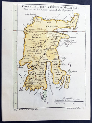
1752 Bellin Antique Map of the Island of Sulawesi, formerly Celebes, Indonesia
- Title: Carte De L'Isle Celebes ou Macassar...S Bellin
- Date: 1752
- Condition : (A+) Fine Condition
- Ref: 60919
- Size: 10in x 7 1/2in (255m x 190mm)
Description:
This fine, original copper-plate engraved antique map of the Indonesian Island of Sulawesi, formerly known as Celebes, by Jacques Nicolas Bellin in 1752 was published in Antoine François Prevosts 15 volumes of Histoire Generale des Voyages written by Prevost & other authors between 1746-1790.
Sulawesi, formerly known as Celebes, is one of the four Greater Sunda Islands, and the world\'s eleventh-largest island, it is situated east of Borneo, west of the Maluku Islands, and south of Mindanao and the Sulu Archipelago. Within Indonesia, only Sumatra, Borneo and Papua are larger in territory, and only Java and Sumatra have larger populations.
Starting in the 13th century, access to prestige trade goods and to sources of iron started to alter long-standing cultural patterns and to permit ambitious individuals to build larger political units. It is not known why these two ingredients appeared together; one was perhaps the product of the other.
In 1367, several identified polities, located on the island, were mentioned in the Javanese manuscript Nagarakretagama dated from the Majapahit period. Canto 14 mentioned polities including Gowa, Makassar, Luwu and Banggai. It seems that by the 14th century, polities in the island were connected in an archipelagic maritime trading network, centered in the Majapahit port in East Java. By 1400, a number of nascent agricultural principalities had arisen in the western Cenrana valley, as well as on the south coast and on the west coast near modern Parepare.
The first Europeans to visit the island (which they believed to be an archipelago due to its contorted shape) were the Portuguese sailors Simão de Abreu, in 1523, and Gomes de Sequeira (among others) in 1525, sent from the Moluccas in search of gold, which the islands had the reputation of producing. A Portuguese base was installed in Makassar in the first decades of the 16th century, lasting until 1665, when it was taken by the Dutch. The Dutch had arrived in Sulawesi in 1605 and were quickly followed by the English, who established a factory in Makassar. From 1660, the Dutch were at war with Gowa, the major Makasar west coast power. In 1669, Admiral Speelman forced the ruler, Sultan Hasanuddin, to sign the Treaty of Bongaya, which handed control of trade to the Dutch East India Company. The Dutch were aided in their conquest by the Bugis warlord Arung Palakka, ruler of the Bugis kingdom of Bone. The Dutch built a fort at Ujung Pandang, while Arung Palakka became the regional overlord and Bone the dominant kingdom. Political and cultural development seems to have slowed as a result of the status quo.
General Definitions:
Paper thickness and quality: - Heavy and stable
Paper color : - off white
Age of map color: - Early
Colors used: - Green, Yellow,
General color appearance: - Authentic
Paper size: - 10in x 7 1/2in (255m x 190mm)
Plate size: - 9in x 6 1/2in (230mm x 160mm)
Margins: - Min 1/2in (6mm)
Imperfections:
Margins: - None
Plate area: - None
Verso: - None
Background:
One of Antoine Francois Prevosts monumental undertakings was his history of exploration & discovery in 15 volumes titledHistoire Générale des Voyages written between 1746-1759 and was extended to 20 volumes after his death by various authors.
The 20 volumes cover the early explorations & discoveries on 3 continents: Africa (v. 1-5), Asia (v. 5-11), and America (v. 12-15) with material on the finding of the French, English, Dutch, and Portugese.
A number of notable cartographers and engravers contributed to the copper plate maps and views to the 20 volumes including Nicolas Bellin, Jan Schley, Chedel, Franc Aveline, Fessard, and many others.
The African volumes cover primarily coastal countries of West, Southern, and Eastern Africa, plus the Congo, Madagascar, Arabia and the Persian Gulf areas.
The Asian volumes cover China, Korea, Tibet, Japan, Philippines, and countries bordering the Indian Ocean.
Volume 11 includes Australia and Antarctica.
Volumes 12-15 cover voyages and discoveries in America, including the East Indies, South, Central and North America.
Volumes 16-20 include supplement volumes & tables along with continuation of voyages and discoveries in Russia, Northern Europe, America, Asia & Australia.
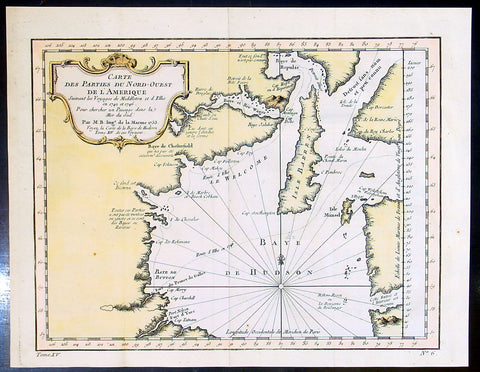
1753 Bellin & Henry Ellis Antique Map of Hudsons Bay, Search for the NW Passage
- Title : Carte Des parties Du Nord-Ouest De L Amerique..Par M.B....1753
- Ref #: 91259
- Size: 12 1/2in x 10in (320m x 255mm)
- Date : 1753
- Condition: (A+) Fine Condition
Description:
This fine, original copper-plate engraved antique map of Hudsons Bay, Canada and Henry Ellis voyage to discover the North West passage by Jacques Nicolas Bellin in 1755 was published in Antoine François Prevosts 15 volumes of Histoire Generale des Voyageswritten by Prevost & other authors between 1746-1790.
Henry Ellis 1721 – 1806 was an explorer, author, and a colonial governor of U.S. state of Georgia and Nova Scotia.
Ellis was born in County Monaghan, Ireland. He was educated in law at the Temple Church in London. In May 1746, he went out as agent of a company for the discovery of the Northwest Passage. After extinguishing with difficulty a fire in his ship, he sailed to Greenland, where he exchanged commodities with the Inuit peoples on 8 July. He then proceeded to Fort Nelson, and wintered in Hayes River. He renewed his efforts in June 1747, without success, and returned to England; where he arrived on 14 October. He published an accounts of his explorations in 1748, entitled \"Voyage made to Hudson\'s Bay in 1746, by the Dobbs Galley and The California, to discover a Northwest Passage\" and in 1750 published \"Considerations on the Great Advantages which would Arise from the Discovery of the North West Passage\". After publishing these accounts, Ellis was inducted into the Royal Society.
From 1750 to 1755, Ellis worked as a slave trader, purchasing slaves from Africa and shipping them to Jamaica.
Lord Halifax, President of the Board of Trade named Ellis lieutenant governor of Georgia, 15 August 1756. Ellis arrived at Savannah, Georgia on 16 February 1757, and on 17 May 1758, was made royal governor. His administration of the colony was highly esteemed. Recognizing the danger posed to the colony by hostile neighbors, he established a treaty with the Creeks. He published \"Heat of the Weather in Georgia\" in Philosophical trans of the Royal Society in 1758. The subtropical climate took its toll on his health, and he had to be removed from governor then left Georgia on 2 November 1760, and stopping in New York to request military assistance to the southern colonies.
After his return to England his knowledge of American affairs were called into requisition for developing the plan for taxing the colonies, and in return for this service he was rewarded with sinecure offices. From 1761 to 1763 he held the commission of governor of Nova Scotia, though he did not enter on the duties of his office. He afterward resided in Italy, principally occupied in scientific researches.Before he died he had a friendship with the creek leader.
He died on January 21, 1806 (aged 84–85) in Naples, Italy.
General Definitions:
Paper thickness and quality: - Heavy and stable
Paper color : - off white
Age of map color: - Early
Colors used: - Yellow, green, red
General color appearance: - Authentic
Paper size: - 12 1/2in x 10in (320m x 255mm)
Plate size: - 11in x 8in (280mm x 205mm)
Margins: - Min 1/2in (12mm)
Imperfections:
Margins: - None
Plate area: - Folds as issued
Verso: - None
Background:
One of Antoine Francois Prevosts monumental undertakings was his history of exploration & discovery in 15 volumes titledHistoire Générale des Voyages written between 1746-1759 and was extended to 20 volumes after his death by various authors.
The 20 volumes cover the early explorations & discoveries on 3 continents: Africa (v. 1-5), Asia (v. 5-11), and America (v. 12-15) with material on the finding of the French, English, Dutch, and Portugese.
A number of notable cartographers and engravers contributed to the copper plate maps and views to the 20 volumes including Nicolas Bellin, Jan Schley, Chedel, Franc Aveline, Fessard, and many others.
The African volumes cover primarily coastal countries of West, Southern, and Eastern Africa, plus the Congo, Madagascar, Arabia and the Persian Gulf areas.
The Asian volumes cover China, Korea, Tibet, Japan, Philippines, and countries bordering the Indian Ocean.
Volume 11 includes Australia and Antarctica.
Volumes 12-15 cover voyages and discoveries in America, including the East Indies, South, Central and North America.
Volumes 16-20 include supplement volumes & tables along with continuation of voyages and discoveries in Russia, Northern Europe, America, Asia & Australia.

1753 Bellin Antique Map of Australia & New Zealand - Carte Reduite.....Australes
Antique Map
- Title : Carte Reduite des Terres Australes pour Servir a l'Histoire des Voyages...1753
- Ref #: 17027
- Size: 13 1/2in x 10in (340mm x 255mm)
- Date : 1753
- Condition: (A+) Fine Condition
Description:
This original copper plate engraved antique map of Australia - one of the earliest, near complete maps, dedicated to the Island Continent - was engraved in 1753 by Jacques Nicolas Bellin - date engraved in the title -and was published in Antoine Prevosts Histoire Generale Des Voyages.
Background: This is one of the few 18th century maps to focus on the Australian continent prior to Cook's famous first voyage from 1768-1771. Mainland Australia is connected to both Tasmania (Terre de Van Diemen) and Papua New Guinea (Nouv. Guinee). Along the imaginary eastern coastline is a note that reads: "I suppose that the land of Diemen can join with the land of the Holy Ghost, but this is without proof." A partial coastline of New Zealand is shown peeking out of the corner of the map, with a note that it was discovered by Abel Tasman in 1642 and speculation that it might be part of a great southern continent. This is an important map of Australia depicting the interesting theories made prior to exploration of the region later in the 18th century. (Ref: Tooley; M&B)
General Description:
Paper thickness and quality: - Heavy and stable
Paper color: - off white
Age of map color: -
Colors used: -
General color appearance: -
Paper size: - 13 1/2in x 10in (340mm x 255mm)
Plate size: - 11 1/2in x 8 1/2in (295mm x 215mm)
Margins: - Min 1in (25mm)
Imperfections:
Margins: - None
Plate area: - Folds as issued
Verso: - None

1753 Bellin Antique Map of Australia & New Zealand - Carte Reduite.....Australes
Antique Map
- Title : Carte Reduite des Terres Australes pour Servir a l'Histoire des Voyages...1753
- Ref #: 17040
- Size: 15in x 10in (380mm x 255mm)
- Date : 1753
- Condition: (A+) Fine Condition
Description:
This original beautifully hand coloured copper plate engraved antique map of Australia - one of the earliest, near complete maps, dedicated to the Island Continent - was engraved in 1753 by Jacques Nicolas Bellin - date engraved in the title -and was published in the 1753 edition of Prevosts Histoire Generale Des Voyages.
Background: This is one of the few 18th century maps to focus on the Australian continent prior to Cook's famous first voyage from 1768-1771. Mainland Australia is connected to both Tasmania (Terre de Van Diemen) and Papua New Guinea (Nouv. Guinee). Along the imaginary eastern coastline is a note that reads: "I suppose that the land of Diemen can join with the land of the Holy Ghost, but this is without proof." A partial coastline of New Zealand is shown peeking out of the corner of the map, with a note that it was discovered by Abel Tasman in 1642 and speculation that it might be part of a great southern continent. This is an important map of Australia depicting the interesting theories made prior to exploration of the region later in the 18th century. (Ref: Tooley; M&B)
General Description:
Paper thickness and quality: - Heavy and stable
Paper color: - off white
Age of map color: - Early
Colors used: - Yellow, green, red, brown.
General color appearance: - Authentic and fresh
Paper size: - 15in x 10in (380mm x 255mm)
Plate size: - 11 1/2in x 8 1/2in (295mm x 215mm)
Margins: - Min 1in (25mm)
Imperfections:
Margins: - None
Plate area: - Folds as issued
Verso: - None
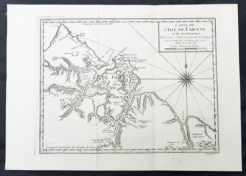
1753 Bellin Antique Map of The Island of Cayenne French Guyana, South America
- Title: Carte de L Isle De Caienne et de ses Environs...1753
- Date: 1753
- Condition : (A+) Fine Condition
- Ref: 92015
- Size: 15in x 11in (390mm x 275mm)
Description:
This fine, original copper-plate engraved antique map of the City Island of Cayenne in French Guyana, South America by Jacques Nicolas Bellin was engraved in 1753 - dated - and was published in Antoine François Prevosts 15 volumes of Histoire Generale des Voyages written by Prevost & other authors between 1746-1790.
Cayenne is the capital city of French Guiana, an overseas region and department of France located in South America. The city stands on a former island at the mouth of the Cayenne River on the Atlantic coast. The city\'s motto is fert aurum industria, which means \"work brings wealth.
Ignored by Spanish explorers, who found the region too hot and poor to be claimed, the region was not colonized until 1604, when a French settlement was founded. However, it was soon destroyed by the Portuguese, who were determined to enforce the provisions of the Treaty of Tordesillas. French colonists returned in 1643 and founded Cayenne, but they were forced to leave once more following Amerindian attacks. In 1664, France finally succeeded at establishing a permanent settlement at Cayenne. Over the next decade the colony changed hands between the French, Dutch, and English, before being restored to France. It was captured by an Anglo-Portuguese force at the invasion of Cayenne in 1809 and administered from Brazil until 1814, when it was returned to French control. It was used as a French penal colony from 1854 to 1938.
General Definitions:
Paper thickness and quality: - Heavy and stable
Paper color : - off white
Age of map color: -
Colors used: -
General color appearance: -
Paper size: - 13in x 10in (330mm x 255mm)
Plate size: - 12in x 9in (305mm x 230mm)
Margins: - Min 1/2in (12mm)
Imperfections:
Margins: - None
Plate area: - None
Verso: - None
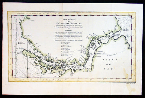
1753 Bellin Antique Map of the Magellan Straits, South America
- Title : Carte Reduite du Detroit De Magellan...1753
- Ref #: 91218
- Size: 15in x 10in (380mm x 255mm)
- Date : 1753
- Condition: (A+) Fine Condition
Description:
This fine hand coloured original antique map of the Magellan Straits between the South American mainland and Tierra Del Fuego - with major points discovered and remarked in a 9 point legend - was engraved by Jacques Nicolas Bellin in 1753 - the date is engraved in the title cartouche - and was published in Antoine-François Prevost's monumental 20 volume edition of L`Histoire Generale des Voyages published by Pierre de Hondt, The Hague between 1747 & 1780. (Ref: Tooley; M&B)
General Description:
Paper thickness and quality: - Heavy and stable
Paper color: - off white
Age of map color: - Later
Colors used: - Yellow, green, red
General color appearance: - Authentic
Paper size: - 15in x 10in (380mm x 255mm)
Plate size: - 14in x 8in (355mm x 205mm)
Margins: - Min 1/2in (12mm)
Imperfections:
Margins: - Light stain bottom right corner
Plate area: - None
Verso: - None
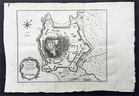
1753 Bellin Antique Map Plan of the City of Cayenne French Guyana, South America
- Title: La Ville De Cayenne...1753
- Date: 1753
- Condition : (A+) Fine Condition
- Ref: 92016
- Size: 15in x 11in (390mm x 275mm)
Description:
This beautifully engraved original antique map a plan of the city of Cayenne capital of French Guyana, South America was engraved by Jacques Nicolas Bellin in 1753 - the date is engraved in the title cartouche - and was published by Jacques Nicolas Bellin for Antoine-François Prevosts 20 volume edition of L`Histoire Generale des Voyages published by Pierre de Hondt, The Hague in 1747. (Ref: Tooley; M&B)
General Description:
Paper thickness and quality: - Heavy and stable
Paper color: - white
Age of map color: -
Colors used: -
General color appearance: -
Paper size: - 15in x 11in (390mm x 275mm)
Plate size: - 11 1/2in x 9 1/2in (290mm x 245mm)
Margins: - min. 1in (25mm)
Imperfections:
Margins: - None
Plate area: - Folds as issued
Verso: - None
Condition : (A+) Fine Condition
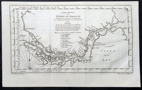
1753 Bellin Original Antique Map of Magellan Straits, Argentine Tierra Del Fuego
- Title : Carte Reduite du Detroit De Magellan...1753
- Ref #: 60961
- Size: 15in x 9 1/2in (380m x 240mm)
- Date : 1753
- Condition: (A+) Fine Condition
Description:
This fine, original copper-plate engraved antique map of the Magellan Straits between the South American mainland and Tierra Del Fuego map - with major points of discovery and remarks in a 9 legend points by Jacques Nicolas Bellin was engraved in 1753 - dated - and was published in Antoine-François Prevosts L Histoire Generale des VoyagesPierre de Hondt, The Hague.
General Definitions:
Paper thickness and quality: - Heavy and stable
Paper color : - off white
Age of map color: -
Colors used: -
General color appearance: -
Paper size: - 15in x 9 1/2in (380m x 240mm)
Plate size: - 14 1/2in x 8in (370mm x 205mm)
Margins: - Min 1/2in (12mm)
Imperfections:
Margins: - None
Plate area: - Folds as issued
Verso: - None
Background:
Antoine François Prevost d Exiles 1697 – 1763, usually known simply as the Abbé Prévost, was a French author and novelist.He was born at Hesdin, Artois, and first appears with the full name of Prevost d Exiles, in a letter to the booksellers of Amsterdam in 1731. His father, Lievin Prévost, was a lawyer, and several members of the family had embraced the ecclesiastical estate. Prevost was educated at the Jesuit school of Hesdin, and in 1713 became a novice of the order in Paris, pursuing his studies at the same time at the college in La Flèche.
At the end of 1716 he left the Jesuits to join the army, but soon tired of military life, and returned to Paris in 1719, apparently with the idea of resuming his novitiate. He is said to have travelled in the Netherlands about this time; in any case he returned to the army, this time with a commission. Some biographers have assumed that he suffered some of the misfortunes assigned to his hero Des Grieux. Whatever the truth, he joined the learned community of the Benedictines of St Maur, with whom he found refuge, he himself says, after the unlucky termination of a love affair. He took his vows at Jumièges in 1721 after a year\'s novitiate, and in 1726 took priests orders at St Germer de Flaix. He spent seven years in various houses of the order, teaching, preaching and studying. In 1728 he was sent to the Abbey of Saint-Germain-des-Pres, Paris, where he contributed to the Gallia Christiana, a work of historiographic documentation undertaken communally by the monks in continuation of the works of Denys de Sainte-Marthe, who had been a member of their order. His restless spirit made him seek from the Pope a transfer to the easier rule of Cluny; but he left the abbey without leave (1728), and, learning that his superiors had obtained a lettre de cachet against him, fled to England.
In London he acquired a wide knowledge of English history and literature, as can be seen in his writings. Before leaving the Benedictines Prévost had begun perhaps his most famous novel, Mémoires et aventures d’un homme de qualité qui s’est retiré du monde, the first four volumes of which were published in Paris in 1728, and two years later at Amsterdam. In 1729 he left England for the Netherlands, where he began to publish (Utrecht, 1731) a novel, the material of which, at least, had been gathered in London Le Philosophe anglais, ou Histoire de Monsieur Cleveland, fils naturel de Cromwell, ecrite par lui-même, et traduite de l anglais (Paris 1731-1739, 8 vols., but most of the existing sets are partly Paris and partly Utrecht). A spurious fifth volume (Utrecht, 1734) contained attacks on the Jesuits, and an English translation of the whole appeared in 1734.
Meanwhile, during his residence at the Hague, he engaged on a translation of De Thou\'s Historia, and, relying on the popularity of his first book, published at Amsterdam a Suite in three volumes, forming volumes v, vi, and vii of the original Mémoires et aventures d’un homme de qualite. The seventh volume contained the famous Manon Lescaut, separately published in Paris in 1731 as Histoire du Chevalier des Grieux et de Manon Lescaut. The book was eagerly read, chiefly in pirated copies, being forbidden in France. In 1733 he left the Hague for London in company of a lady whose character, according to Prevosts enemies, was doubtful. In London he edited a weekly gazette on the model of Joseph Addisons Spectator, Le Pour et contre, which he continued to produce in collaboration with the playwright Charles-Hugues Le Febvre de Saint-Marc, with short intervals, until 1740.
In the autumn of 1734 Prevost was reconciled with the Benedictines, and, returning to France, was received in the Benedictine monastery of La Croix-Saint-Leufroy in the diocese of Evreux to pass through a new, though brief, novitiate. In 1735 he was dispensed from residence in a monastery by becoming almoner to the Prince de Conti, and in 1754 obtained the priory of St Georges de Gesnes. He continued to produce novels and translations from the English, and, with the exception of a brief exile (1741–1742) spent in Brussels and Frankfurt, he resided for the most part at Chantilly until his death, which took place suddenly while he was walking in the neighbouring woods. The cause of his death, the rupture of an aneurysm, is all that is definitely known. Stories of crime and disaster were related of Prevost by his enemies, and diligently repeated, but appear to be apocryphal.
Prevosts other works include:
- Le Doyen de Killerine, Killerine, histoire morale composee sur les memoires d une illustre famille d Irlande (Paris, 1735; 2nd part, the Hague, 1739, 3rd, 4th and 5th parts, 1740)
- Tout pour l\'amour (1735), a translation of Drydens tragedy
- Histoire d une Grecque moderne (Amsterdam [Paris] 2 vols., 1740)
- l Histoire de Marguerite d Anjou (Amsterdam [Paris] 2 vols., 1740)
Memoires pour servir a l histoire de Malte (Amsterdam, 1741)
- Campagnes philosophiques, ou memoires ... contenant l histoire de la guerre d Irlande (Amsterdam, 1741)
- Histoire de Guillaume le Conquerant (Paris, 1742)
- Histoire generale des voyages (15 vols., Paris, 1746-1759), continued by other writers
- Manuel Lexique (Paris, 1750), continued by other writers
- Translations from Samuel Richardson:
Lettres anglaises ou Histoire de Miss Clarisse Harlovie (1751), from Richardson\'s Clarissa, and Nouvelles lettres anglaises, ou Histoire du chevalier Grandisson (Sir Charles Grandison, 1755).
- Mémoires pour servir a l\'histoire de la vertu (1762), from Mrs Sheridan\'s
Memoires of Miss Sidney Bidulph
- Histoire de la maison de Stuart (3 vols., 1740) from Hume\'s History of England to 1688
- Le Monde moral, ou Mémoires pour servir a l\'histoire du coeur humain (2 vols., Geneva, 1760)
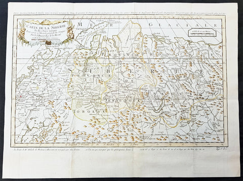
1754 Bellin & Delisle Original Antique Map of Siberia, Russia - after Delisle & Kirilov
- Title : Carte De La Siberie...S Bellin
- Date : 1755
- Ref # : 25538
- Size : 18 3/4in x 14in (480mm x 360mm)
- Condition: (A+) Fine Condition
Description:
This fine large, original copper-plate engraved antique map of Siberia, Eastern Russia by Jacques Nicolas Bellin in 1754 - after Joseph Nicolas Delisle - was published in Antoine François Prevosts 15 volumes of Histoire Generale des Voyages written by Prevost & other authors between 1746-1790.
This detailed map of Siberia, extends from the White & Caspian Seas in the west to Irkuckoi Province, Jakutky on the Lena River and regions just to the east. Centered on the Jenisi River.
The map also notes the trip taken by JN Delisle from Moscow to Beryozovo, in the Khanty-Mansi Autonomous Okrug region to observe the transit of Venus in 1740.
This map by Bellin was taken from JN Delsile, brother of Guillaume Delisle, responsible along with Russian Ivan Kirilov in surveying & publishing the first complete atlas of Russia, Atlas Russicus in 1745.
Jacques Nicolas Delisle was invited by Peter the Great to survey the vast empire of Imperial Russia. Initially accompanied by his step-brother Louis, in 1726 the two Parisians journeyed to Russia (now under the reign of Catherine I) to start their surveys.
At first, Delisle also worked with Ivan Kirilov, with whom he co-founded the St Petersburg Academy of Sciences. However, the two men did not always see eye to eye, and Kirilov went on to produce an incomplete atlas which was published in 1734, before the French team had finished their surveys. Kirilov died in 1737, eight years before the eventual publication of Delisle\'s atlas.
The Atlas Russicus is effectively in two parts: the first covering European Russia in 13 numbered maps (scale 1; 1.527.000), the second covering Siberia in six maps. scale (1: 3.360.000). On map 19 Ostium fluvii Amur the extreme point of Alaska and the Aleutian islands.
It is scarcely necessary to look at a map of Russia - with which we must include Siberia - to visualize the daunting task facing Russian map makers. Indeed, considering the vastness of their territory and the lack of skilled cartographers, it is surprising that relatively good maps were available for engraving and printing in most of the well known sixteenth and seventeenth century atlases. Generally, maps of that time were based on material brought back from Moscow by visitors from the West.
General Definitions:
Paper thickness and quality: - Heavy and stable
Paper color : - off white
Age of map color: - Early
Colors used: - Green, Yellow,
General color appearance: - Authentic
Paper size: - 18 3/4in x 14in (480mm x 360mm)
Plate size: - 18 1/2in x 11 3/4in (470mm x 300mm)
Margins: - Min 1/2in (6mm)
Imperfections:
Margins: - None
Plate area: - Folds as issued
Verso: - None
Background:
One of Antoine Francois Prevosts monumental undertakings was his history of exploration & discovery in 15 volumes titledHistoire Générale des Voyages written between 1746-1759 and was extended to 20 volumes after his death by various authors.
The 20 volumes cover the early explorations & discoveries on 3 continents: Africa (v. 1-5), Asia (v. 5-11), and America (v. 12-15) with material on the finding of the French, English, Dutch, and Portugese.
A number of notable cartographers and engravers contributed to the copper plate maps and views to the 20 volumes including Nicolas Bellin, Jan Schley, Chedel, Franc Aveline, Fessard, and many others.
The African volumes cover primarily coastal countries of West, Southern, and Eastern Africa, plus the Congo, Madagascar, Arabia and the Persian Gulf areas.
The Asian volumes cover China, Korea, Tibet, Japan, Philippines, and countries bordering the Indian Ocean.
Volume 11 includes Australia and Antarctica.
Volumes 12-15 cover voyages and discoveries in America, including the East Indies, South, Central and North America.
Volumes 16-20 include supplement volumes & tables along with continuation of voyages and discoveries in Russia, Northern Europe, America, Asia & Australia.
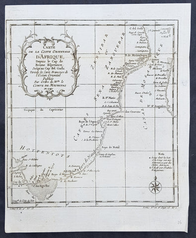
1755 Bellin Antique Map South East Africa from The Cape to Tanzania - Hottentots
- Title : Carte de la Coste orientale d Afrique , depuis le cap de Bonne Espérance jusqu\' au cap del Gada . Tirée de la carte françoise de l Océan Oriental puliée ... le Comte de Maurepas en 1740
- Size: 12in x 10in (305mm x 255mm)
- Ref #: 92506
- Date : 1757
- Condition: (A+) Fine Condition
Description:
This fine original copper-plate engraved antique map of St Helena Bay in Western Cape South Africa by Jacques Nicolas Bellin was published in 1757 in Antoine François Prevosts 15 volumes of Histoire Generale des Voyages written by Prevost & other authors between 1746-1790.
Historically, Saint Helena Bay is the location where Vasco da Gama, first set foot in South Africa. The date of this event was recorded as November 7, 1497.
The bay was named Bahia de Santa Helena (Portuguese for its current name) after Saint Helena a devout, influential Christian and mother of Constantine I. This location was also the first setting of a battle between the indigenous Khoikhoi people and early European explorers.
General Definitions:
Paper thickness and quality: - Heavy and stable
Paper color : - off white
Age of map color: -
Colors used: -
General color appearance: -
Paper size: - 12in x 10in (305mm x 255mm)
Plate size: - 10in x 8in (255mm x 205mm)
Margins: - Min 1/2in (12mm)
Imperfections:
Margins: - None
Plate area: - Folds as issued
Verso: - None
Background:
One of Antoine Francois Prevosts monumental undertakings was his history of exploration & discovery in 15 volumes titledHistoire Générale des Voyages written between 1746-1759 and was extended to 20 volumes after his death by various authors.
The 20 volumes cover the early explorations & discoveries on 3 continents: Africa (v. 1-5), Asia (v. 5-11), and America (v. 12-15) with material on the finding of the French, English, Dutch, and Portugese.
A number of notable cartographers and engravers contributed to the copper plate maps and views to the 20 volumes including Nicolas Bellin, Jan Schley, Chedel, Franc Aveline, Fessard, and many others.
The African volumes cover primarily coastal countries of West, Southern, and Eastern Africa, plus the Congo, Madagascar, Arabia and the Persian Gulf areas.
The Asian volumes cover China, Korea, Tibet, Japan, Philippines, and countries bordering the Indian Ocean.
Volume 11 includes Australia and Antarctica.
Volumes 12-15 cover voyages and discoveries in America, including the East Indies, South, Central and North America.
Volumes 16-20 include supplement volumes & tables along with continuation of voyages and discoveries in Russia, Northern Europe, America, Asia & Australia.
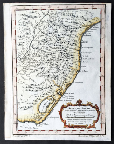
1755 Nicolas Bellin Original Antique Map of Brazil, Camarin to Cape St Marie
- Title : Suite du Bresil.
- Ref #: 61078
- Size: 10in x 7 1/2in (255mm x 190mm)
- Date : 1755
- Condition: (A+) Fine Condition
Description:
This fine, original copper-plate engraved antique map of Southern Brazil from from Camarin to Cape St Marie by Jacques Nicolas Bellin in 1755 was published in Antoine François Prevosts 15 volumes of Histoire Generale des Voyages written by Prevost & other authors between 1746-1790.
The land now called Brazil was claimed for the Portuguese Empire on 22 April 1500, with the arrival of the Portuguese fleet commanded by Pedro Álvares Cabral. The Portuguese encountered indigenous peoples divided into several tribes, most of whom spoke languages of the Tupi–Guarani family, and fought among themselves. Though the first settlement was founded in 1532, colonization effectively began in 1534, when King Dom João III of Portugal divided the territory into the fifteen private and autonomous Captaincy Colonies of Brazil.
However, the decentralized and unorganized tendencies of the captaincy colonies proved problematic, and in 1549 the Portuguese king restructured them into the Governorate General of Brazil, a single and centralized Portuguese colony in South America. In the first two centuries of colonization, Indigenous and European groups lived in constant war, establishing opportunistic alliances in order to gain advantages against each other. By the mid-16th century, cane sugar had become Brazil\'s most important exportation product, and slaves purchased in Sub-Saharan Africa, in the slave market of Western Africa (not only those from Portuguese allies of their colonies in Angola and Mozambique), had become its largest import, to cope with plantations of sugarcane, due to increasing international demand for Brazilian sugar
By the end of the 17th century, sugarcane exports began to decline, and the discovery of gold by bandeirantes in the 1690s would become the new backbone of the colony\'s economy, fostering a Brazilian Gold Rush which attracted thousands of new settlers to Brazil from Portugal and all Portuguese colonies around the world. This increased level of immigration in turn caused some conflicts between newcomers and old settlers.
Portuguese expeditions known as Bandeiras gradually advanced the Portugal colonial original frontiers in South America to approximately the current Brazilian borders. In this era other European powers tried to colonize parts of Brazil, in incursions that the Portuguese had to fight, notably the French in Rio during the 1560s, in Maranhão during the 1610s, and the Dutch in Bahia and Pernambuco, during the Dutch–Portuguese War, after the end of Iberian Union.
The Portuguese colonial administration in Brazil had two objectives that would ensure colonial order and the monopoly of Portugal\'s wealthiest and largest colony: to keep under control and eradicate all forms of slave rebellion and resistance, such as the Quilombo of Palmares, and to repress all movements for autonomy or independence, such as the Minas Conspiracy
General Definitions:
Paper thickness and quality: - Heavy and stable
Paper color : - off white
Age of map color: - Early
Colors used: - Green, Yellow,
General color appearance: - Authentic
Paper size: - 10in x 7 1/2in (255mm x 190mm)
Plate size: - 9 1/2in x 7in (240mm x 180mm)
Margins: - Min 1/2in (12mm)
Imperfections:
Margins: - None
Plate area: - None
Verso: - None
Background:
One of Antoine Francois Prevosts monumental undertakings was his history of exploration & discovery in 15 volumes titledHistoire Générale des Voyages written between 1746-1759 and was extended to 20 volumes after his death by various authors.
The 20 volumes cover the early explorations & discoveries on 3 continents: Africa (v. 1-5), Asia (v. 5-11), and America (v. 12-15) with material on the finding of the French, English, Dutch, and Portugese.
A number of notable cartographers and engravers contributed to the copper plate maps and views to the 20 volumes including Nicolas Bellin, Jan Schley, Chedel, Franc Aveline, Fessard, and many others.
The African volumes cover primarily coastal countries of West, Southern, and Eastern Africa, plus the Congo, Madagascar, Arabia and the Persian Gulf areas.
The Asian volumes cover China, Korea, Tibet, Japan, Philippines, and countries bordering the Indian Ocean.
Volume 11 includes Australia and Antarctica.
Volumes 12-15 cover voyages and discoveries in America, including the East Indies, South, Central and North America.
Volumes 16-20 include supplement volumes & tables along with continuation of voyages and discoveries in Russia, Northern Europe, America, Asia & Australia.
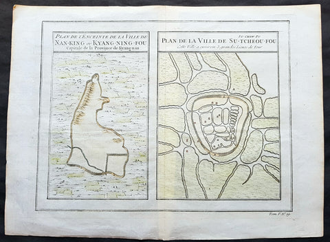
1755 Prevost & Schley Antique Map, View of Nanking or Nanjing in Jiangsu, China
- Title: Plan De L Enceinte de la Ville De Nan-King ou Kyang-Ning-Fou Capitale de la Province de Kyang-nan; Plan de la Ville De Su-Tcheou-Fou
- Date: 1755
- Condition : (A+) Fine Condition
- Ref: 15844
- Size: 13 1/2in x 10in (345mm x 255mm)
Description:
This fine, original copper-plate engraved antique map a birds-eye view of the walled cities of Nanjing & Zhenzhou, in the Jiangsu Province of China by Jakob van Schley in 1755 was published in Antoine François Prevosts 15 volumes of Histoire Generale des Voyageswritten by Prevost & other authors between 1746-1790.
Nanjing formerly romanized as Nanking and Nankin, is the capital of Jiangsu province of the People\'s Republic of China and the second largest city in the East China region, with an administrative area of 6,600 km2 (2,500 sq mi) and a total population of 8,270,500.
Situated in the Yangtze River Delta region, Nanjing has a prominent place in Chinese history and culture, having served as the capital of various Chinese dynasties, kingdoms and republican governments dating from the 3rd century to 1949, and has thus long been a major center of culture, education, research, politics, economy, transport networks and tourism, being the home to one of the world\'s largest inland ports.
Nanjing, one of the nation\'s most important cities for over a thousand years, is recognized as one of the Four Great Ancient Capitals of China. It has been one of the world\'s largest cities, enjoying peace and prosperity despite wars and disasters. Nanjing served as the capital of Eastern Wu, one of the three major states in the Three Kingdoms period (211–280); the Eastern Jin and each of the Southern Dynasties (Liu Song, Southern Qi, Liang and Chen), which successively ruled southern China from 317–589; the Southern Tang, one of the Ten Kingdoms (937–76); the Ming dynasty when, for the first time, all of China was ruled from the city (1368–1421);[15] and the Republic of China (1927–37, 1945–49) prior to its flight to Taiwan during the Chinese Civil War. The city also served as the seat of the rebel Taiping Heavenly Kingdom (1851–64) and the Japanese puppet regime of Wang Jingwei (1940–45) during the Second Sino-Japanese War. It suffered appalling atrocities in both conflicts, including the Nanjing Massacre.
General Definitions:
Paper thickness and quality: - Heavy and stable
Paper color : - off white
Age of map color: - Early
Colors used: - Yellow, green, orange
General color appearance: - Authentic
Paper size: - 13 1/2in x 10in (345mm x 255mm)
Plate size: - 11 1/2in x 9in (295mm x 230mm)
Margins: - Min 1/2in (12mm)
Imperfections:
Margins: - None
Plate area: - None
Verso: - None
Background:
One of Antoine Francois Prevosts monumental undertakings was his history of exploration & discovery in 15 volumes titledHistoire Générale des Voyages written between 1746-1759 and was extended to 20 volumes after his death by various authors.
The 20 volumes cover the early explorations & discoveries on 3 continents: Africa (v. 1-5), Asia (v. 5-11), and America (v. 12-15) with material on the finding of the French, English, Dutch, and Portugese.
A number of notable cartographers and engravers contributed to the copper plate maps and views to the 20 volumes including Nicolas Bellin, Jan Schley, Chedel, Franc Aveline, Fessard, and many others.
The African volumes cover primarily coastal countries of West, Southern, and Eastern Africa, plus the Congo, Madagascar, Arabia and the Persian Gulf areas.
The Asian volumes cover China, Korea, Tibet, Japan, Philippines, and countries bordering the Indian Ocean.
Volume 11 includes Australia and Antarctica.
Volumes 12-15 cover voyages and discoveries in America, including the East Indies, South, Central and North America.
Volumes 16-20 include supplement volumes & tables along with continuation of voyages and discoveries in Russia, Northern Europe, America, Asia & Australia.
Jakob van der Schley aka Jakob van Schley (1715 - 1779) was a Dutch draughtsman and engraver. He studied under Bernard Picart (1673-1733) whose style he subsequently copied. His main interests were engraving portraits and producing illustrations for \\\"La Vie de Marianne\\\" by Pierre Carlet de Chamblain de Marivaux (1688-1763) published in The Hague between 1735 and 1747.
He also engraved the frontispieces for a 15-volume edition of the complete works of Pierre de Brantôme (1540-1614), Oeuvres du seigneur de Brantôme, published in The Hague in 1740.
He is also responsible for most of the plates in the Hague edition of Prévosts Histoire générale des voyages. (Ref: Tooley; M&B)
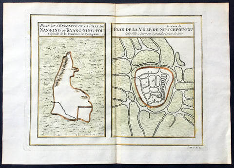
1755 Prevost & Schley Antique Map, View of Nanking or Nanjing in Jiangsu, China
- Title: Plan De L Enceinte de la Ville De Nan-King ou Kyang-Ning-Fou Capitale de la Province de Kyang-nan; Plan de la Ville De Su-Tcheou-Fou
- Date: 1755
- Size: 13 1/2in x 10in (345mm x 255mm)
- Ref: 25695
- Condition : (A+) Fine Condition
Description:
This fine, original copper-plate engraved antique map a birds-eye view of the walled cities of Nanjing & Zhenzhou, in the Jiangsu Province of China by Jakob van Schley in 1755 was published in Antoine François Prevosts 15 volumes of Histoire Generale des Voyageswritten by Prevost & other authors between 1746-1790.
Nanjing formerly romanized as Nanking and Nankin, is the capital of Jiangsu province of the People\'s Republic of China and the second largest city in the East China region, with an administrative area of 6,600 km2 (2,500 sq mi) and a total population of 8,270,500.
Situated in the Yangtze River Delta region, Nanjing has a prominent place in Chinese history and culture, having served as the capital of various Chinese dynasties, kingdoms and republican governments dating from the 3rd century to 1949, and has thus long been a major center of culture, education, research, politics, economy, transport networks and tourism, being the home to one of the world\'s largest inland ports.
Nanjing, one of the nation\'s most important cities for over a thousand years, is recognized as one of the Four Great Ancient Capitals of China. It has been one of the world\'s largest cities, enjoying peace and prosperity despite wars and disasters. Nanjing served as the capital of Eastern Wu, one of the three major states in the Three Kingdoms period (211–280); the Eastern Jin and each of the Southern Dynasties (Liu Song, Southern Qi, Liang and Chen), which successively ruled southern China from 317–589; the Southern Tang, one of the Ten Kingdoms (937–76); the Ming dynasty when, for the first time, all of China was ruled from the city (1368–1421);[15] and the Republic of China (1927–37, 1945–49) prior to its flight to Taiwan during the Chinese Civil War. The city also served as the seat of the rebel Taiping Heavenly Kingdom (1851–64) and the Japanese puppet regime of Wang Jingwei (1940–45) during the Second Sino-Japanese War. It suffered appalling atrocities in both conflicts, including the Nanjing Massacre.
General Definitions:
Paper thickness and quality: - Heavy and stable
Paper color : - off white
Age of map color: - Early
Colors used: - Yellow, green, orange
General color appearance: - Authentic
Paper size: - 13 1/2in x 10in (345mm x 255mm)
Plate size: - 11 1/2in x 9in (295mm x 230mm)
Margins: - Min 1/2in (12mm)
Imperfections:
Margins: - None
Plate area: - None
Verso: - None
Background:
One of Antoine Francois Prevosts monumental undertakings was his history of exploration & discovery in 15 volumes titledHistoire Générale des Voyages written between 1746-1759 and was extended to 20 volumes after his death by various authors.
The 20 volumes cover the early explorations & discoveries on 3 continents: Africa (v. 1-5), Asia (v. 5-11), and America (v. 12-15) with material on the finding of the French, English, Dutch, and Portugese.
A number of notable cartographers and engravers contributed to the copper plate maps and views to the 20 volumes including Nicolas Bellin, Jan Schley, Chedel, Franc Aveline, Fessard, and many others.
The African volumes cover primarily coastal countries of West, Southern, and Eastern Africa, plus the Congo, Madagascar, Arabia and the Persian Gulf areas.
The Asian volumes cover China, Korea, Tibet, Japan, Philippines, and countries bordering the Indian Ocean.
Volume 11 includes Australia and Antarctica.
Volumes 12-15 cover voyages and discoveries in America, including the East Indies, South, Central and North America.
Volumes 16-20 include supplement volumes & tables along with continuation of voyages and discoveries in Russia, Northern Europe, America, Asia & Australia.
Jakob van der Schley aka Jakob van Schley (1715 - 1779) was a Dutch draughtsman and engraver. He studied under Bernard Picart (1673-1733) whose style he subsequently copied. His main interests were engraving portraits and producing illustrations for \\\"La Vie de Marianne\\\" by Pierre Carlet de Chamblain de Marivaux (1688-1763) published in The Hague between 1735 and 1747.
He also engraved the frontispieces for a 15-volume edition of the complete works of Pierre de Brantôme (1540-1614), \\\"Oeuvres du seigneur de Brantôme\\\", published in The Hague in 1740.
He is also responsible for most of the plates in the Hague edition of Prévosts Histoire générale des voyages. (Ref: Tooley; M&B)
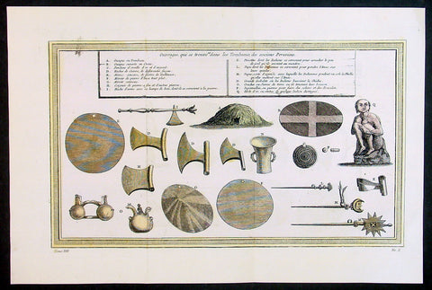
1755 Prevost & Schley Antique Print of Artifacts Recovered from Inca Burial Tomb
- Title: Puvrages qui se trouvent dans les Tombeaux des anciens Peruviens
- Date: 1755
- Condition : (A+) Fine Condition
- Ref: 34132
- Size: 15in x 10in (385mm x 255mm)
Description:
This fine, original copper-plate engraved antique print of artifacts found in an Inca Tomb in Peru by Jakob van Schley in 1755 - after De Bry - was published in Antoine François Prevosts 15 volumes of Histoire Generale des Voyages written by Prevost & other authors between 1746-1790.
The Inca Empire also known as the Incan Empire and the Inka Empire, was the largest empire in pre-Columbian America, and possibly the largest empire in the world in the early 16th century. Its political and administrative structure \"was the most sophisticated found among native peoples\" in the Americas.The administrative, political and military center of the empire was located in Cusco in modern-day Peru. The Inca civilization arose from the highlands of Peru sometime in the early 13th century. Its last stronghold was conquered by the Spanish in 1572.
From 1438 to 1533, the Incas incorporated a large portion of western South America, centered on the Andean Mountains, using conquest and peaceful assimilation, among other methods. At its largest, the empire joined Peru, large parts of modern Ecuador, western and south central Bolivia, northwest Argentina, north and central Chile and a small part of southwest Colombia into a state comparable to the historical empires of Eurasia. Its official language was Quechua.Many local forms of worship persisted in the empire, most of them concerning local sacred Huacas, but the Inca leadership encouraged the worship of Inti – their sun god – and imposed its sovereignty above other cults such as that of Pachamama. The Incas considered their king, the Sapa Inca, to be the \"son of the sun.\"
The Inca Empire was unique in that it lacked many features associated with civilization in the Old World. In the words of one scholar, \"The Incas lacked the use of wheeled vehicles. They lacked animals to ride and draft animals that could pull wagons and plows... [They] lacked the knowledge of iron and steel... Above all, they lacked a system of writing... Despite these supposed handicaps, the Incas were still able to construct one of the greatest imperial states in human history\". Notable features of the Inca Empire include its monumental architecture, especially stonework, extensive road network reaching all corners of the empire, finely-woven textiles, use of knotted strings (quipu) for record keeping and communication, agricultural innovations in a difficult environment, and the organization and management fostered or imposed on its people and their labor.
The Incan economy has been described in contradictory ways by scholars: as \"feudal, slave, socialist (here one may choose between socialist paradise or socialist tyranny)\". The Inca empire functioned largely without money and without markets. Instead, exchange of goods and services was based on reciprocity between individuals and among individuals, groups, and Inca rulers. \"Taxes\" consisted of a labor obligation of a person to the Empire. The Inca rulers (who theoretically owned all the means of production) reciprocated by granting access to land and goods and providing food and drink in celebratory feasts for their subjects.
General Definitions:
Paper thickness and quality: - Heavy and stable
Paper color : - off white
Age of map color: - Early
Colors used: - Yellow, green, red
General color appearance: - Authentic
Paper size: - 15in x 10in (385mm x 255mm)
Plate size: - 14in x 8 1/2in (355mm x 220mm)
Margins: - Min 1in (25mm)
Imperfections:
Margins: - None
Plate area: - Folds as issued
Verso: - None
Background:
One of Antoine Francois Prevosts monumental undertakings was his history of exploration & discovery in 15 volumes titledHistoire Générale des Voyages written between 1746-1759 and was extended to 20 volumes after his death by various authors.
The 20 volumes cover the early explorations & discoveries on 3 continents: Africa (v. 1-5), Asia (v. 5-11), and America (v. 12-15) with material on the finding of the French, English, Dutch, and Portugese.
A number of notable cartographers and engravers contributed to the copper plate maps and views to the 20 volumes including Nicolas Bellin, Jan Schley, Chedel, Franc Aveline, Fessard, and many others.
The African volumes cover primarily coastal countries of West, Southern, and Eastern Africa, plus the Congo, Madagascar, Arabia and the Persian Gulf areas.
The Asian volumes cover China, Korea, Tibet, Japan, Philippines, and countries bordering the Indian Ocean.
Volume 11 includes Australia and Antarctica.
Volumes 12-15 cover voyages and discoveries in America, including the East Indies, South, Central and North America.
Volumes 16-20 include supplement volumes & tables along with continuation of voyages and discoveries in Russia, Northern Europe, America, Asia & Australia.
Jakob van der Schley aka Jakob van Schley (1715 - 1779) was a Dutch draughtsman and engraver. He studied under Bernard Picart (1673-1733) whose style he subsequently copied. His main interests were engraving portraits and producing illustrations for \\\"La Vie de Marianne\\\" by Pierre Carlet de Chamblain de Marivaux (1688-1763) published in The Hague between 1735 and 1747.
He also engraved the frontispieces for a 15-volume edition of the complete works of Pierre de Brantôme (1540-1614), \\\"Oeuvres du seigneur de Brantôme\\\", published in The Hague in 1740.
He is also responsible for most of the plates in the Hague edition of Prévosts Histoire générale des voyages. (Ref: Tooley; M&B)
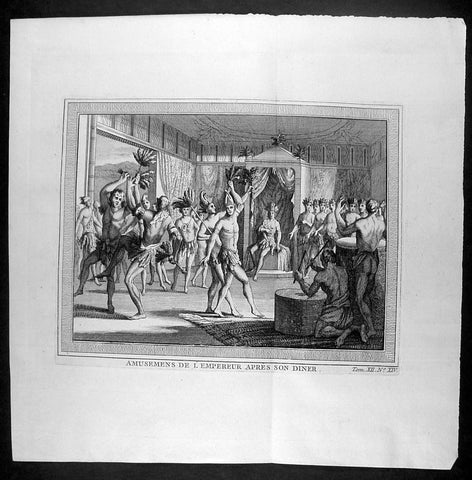
1755 Prevost & Schley Antique Print of Aztec Dancers & Musicians Mexico - after De Bry
- Title : Amusemens De L Empereur Apres Son Diner
- Ref #: 25962
- Size: 10in x 10in (255mm x 255mm)
- Date : 1755
- Condition: (A+) Fine Condition
Description:
This fine, original copper-plate engraved antique print of Aztec dancers and musicians performing for the Aztec Emperor, in modern day Mexico, by Jakob van Schley - after De Bry - in 1755 was published in Antoine François Prevosts 15 volumes of Histoire Generale des Voyages written by Prevost & other authors between 1746-1790.
General Definitions:
Paper thickness and quality: - Heavy and stable
Paper color : - off white
Age of map color: -
Colors used: -
General color appearance: -
Paper size: - 10in x 10in (255mm x 255mm)
Plate size: - 8in x 6in (205mm x 155mm)
Margins: - Min 1in (25mm)
Imperfections:
Margins: - None
Plate area: - None
Verso: - None
Background:
One of Antoine Francois Prevosts monumental undertakings was his history of exploration & discovery in 15 volumes titledHistoire Générale des Voyages written between 1746-1759 and was extended to 20 volumes after his death by various authors.
The 20 volumes cover the early explorations & discoveries on 3 continents: Africa (v. 1-5), Asia (v. 5-11), and America (v. 12-15) with material on the finding of the French, English, Dutch, and Portugese.
A number of notable cartographers and engravers contributed to the copper plate maps and views to the 20 volumes including Nicolas Bellin, Jan Schley, Chedel, Franc Aveline, Fessard, and many others.
The African volumes cover primarily coastal countries of West, Southern, and Eastern Africa, plus the Congo, Madagascar, Arabia and the Persian Gulf areas.
The Asian volumes cover China, Korea, Tibet, Japan, Philippines, and countries bordering the Indian Ocean.
Volume 11 includes Australia and Antarctica.
Volumes 12-15 cover voyages and discoveries in America, including the East Indies, South, Central and North America.
Volumes 16-20 include supplement volumes & tables along with continuation of voyages and discoveries in Russia, Northern Europe, America, Asia & Australia.
Jakob van der Schley aka Jakob van Schley (1715 - 1779) was a Dutch draughtsman and engraver. He studied under Bernard Picart (1673-1733) whose style he subsequently copied. His main interests were engraving portraits and producing illustrations for \\\"La Vie de Marianne\\\" by Pierre Carlet de Chamblain de Marivaux (1688-1763) published in The Hague between 1735 and 1747.
He also engraved the frontispieces for a 15-volume edition of the complete works of Pierre de Brantôme (1540-1614), \\\"Oeuvres du seigneur de Brantôme\\\", published in The Hague in 1740.
He is also responsible for most of the plates in the Hague edition of Prévosts Histoire générale des voyages. (Ref: Tooley; M&B)
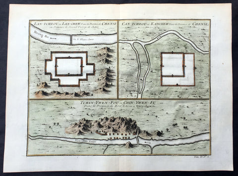
1755 Prevost Antique Map Lanzhou & Zhangye in Gansu - Guiyang in Guizhou, China
- Title: Lan-Tcheou ou Lan-Chew dans la Province Chensi…/Can Tcheou ou Kan-Chew dans la Province de Chensi…/Tchin-Ywen-Fou ou Chin-Ywen-Fu dans la Province de Koei-Tcheou ou Quey-Chew
- Date: 1755
- Size: 13 1/2in x 10in (345mm x 255mm)
- Ref: 25725
- Condition : (A+) Fine Condition
Description:
This fine, original copper-plate engraved antique map a birds-eye view of the walled cities of Lanzhou & Zhangye in the Gansu province of Northern China and the city of Guiyang in the Guizhou province of Southwest China by Jakob van Schley in 1755 was published in Antoine François Prevosts 15 volumes of Histoire Generale des Voyageswritten by Prevost & other authors between 1746-1790.
Lanzhou is the capital and largest city of Gansu Province in Northwest China. The prefecture-level city, located on the banks of the Yellow River
Originally in the territory of the Western Qiang peoples, Lanzhou became part of the territory of the State of Qin in the 6th century BC.
In 81 BC, under the Han dynasty (206 BC–220 AD), it was taken from the Huns\' Huandi Chanyu and made the seat of Jincheng commandery (jùn), and later of the Jincheng county (xian), later renamed Yunwu. The city used to be called the Golden City, and since at least the first millennium BC it was a major link on the ancient Northern Silk Road, and also an important historic Yellow River crossing site. To protect the city, the Great Wall of China was extended as far as Yumen. Parts of the Great Wall still exist within the built-up area.
After the fall of the Han dynasty, Lanzhou became the capital of a succession of tribal states. In the 4th century it was briefly the capital of the independent state of Liang. The Northern Wei dynasty (386–534) reestablished Jincheng commandery, renaming the county Zicheng. Mixed with different cultural heritages, the area at present-day Gansu province, from the 5th to the 11th century, became a center for Buddhist study. Under the Sui Dynasty(581–618) the city became the seat of Lanzhou prefecture for the first time, retaining this name under the Tang dynasty (618–907). In 763 the area was overrun by the Tibetan Empire and in 843 was conquered by the Tang. Later it fell into the hands of the Western Xia dynasty (which flourished in Qinghai from the 11th to 13th century) and was subsequently absorbed by the Song dynasty (960–1126) in 1041. The name Lanzhou was reestablished, and the county renamed Lanzhuan.
After 1127 it fell into the hands of the Jin dynasty, and after 1235 it came into the possession of the Mongol Empire.
Under the Ming dynasty (1368–1644) the prefecture was demoted to a county and placed under the administration of Lintao superior prefecture, but in 1477 Lanzhou was reestablished as a political unit.
The city acquired its current name in 1656, during the Qing dynasty. When Gansu was made a separate province in 1666, Lanzhou became its capital.
In 1739 the seat of Lintao was transferred to Lanzhou, which was later made a superior prefecture called Lanzhou.
Lanzhou was badly damaged during the Dungan revolt in 1864–1875. In the 1920s and 1930s it became a center of Sovietinfluence in northwestern China. During the Second Sino-Japanese War (1937–1945) Lanzhou, linked with Xi\'an by highway in 1935, became the terminus of the 3,200 km (2,000 mi) Chinese–Soviet highway, used as a route for Soviet supplies destined for the Xi\'an area. This highway remained the primary traffic route of northwestern China until the completion of the railway from Lanzhou to Ürümqi, Xinjiang. During the war Lanzhou was heavily bombed by the Japanese.
During the 1937 Japanese invasion of China, the Guominjun Muslim Generals Ma Hongkui and Ma Bufang protected Lanzhou with their cavalry troops, putting up such resistance that the Japanese never captured Lanzhou. The city is the seat of a currently vacant Roman Catholic diocese and was previously the center of a vicariate apostolic(Vicariate Apostolic of Northern Kan-Su)
Zhangye , formerly romanized as Changyeh or known as Kanchow, is a prefecture-level city in central Gansu Province in the People\'s Republic of China. It borders Inner Mongolia on the north and Qinghai on the south. Its central district is Ganzhou, formerly a city of the Western Xia and one of the most important outposts of western China.
Zhangye lies in the center of the Hexi Corridor. The area is on the frontier of China Proper, protecting it from the nomads of the northwest and permitting its armies access to the Tarim Basin. During the Han Dynasty, Chinese armies were often engaged against the Xiongnuin this area. It was also an important outpost on the Silk Road.[citation needed]Before being overrun by the Mongols, it was dominated by the Western Xia, and before by the Uyghurs from at least the early 10th century. Its relation to the larger Uyghur state of Qocho is obscure, but it may have been a vassal.
The Mongol Emperor Kublai Khan is said to have been born in the Dafo Temple, Zhangye, now the site of the longest wooden reclining Buddha in China.[citation needed] Marco Polo\'s journal states that he spent a year in the town during his journey to China.
The pine forests of the Babao Mountains (part of the Qilian range) formerly regulated the flow of the Ruo or Hei Shui, Ganzhou\'s primary river. By ensuring that the meltwaters lasted throughout the summer, they avoided both early flood and later drought for the valley\'s farmers. Despite reports that they should thus be protected in perpetuity, an imperial official in charge of erecting the poles for China\'s telegraph network ordered them cleared in the 1880s. Almost immediately, the region became prone to flooding in the summer and draught in the autumn, arousing local resentment.
Christian missionaries arrived in 1879, after Suzhou was found to be too hostile for their settlement.
Guiyang is the capital of Guizhou province of Southwest China. It is located in the center of the province, situated on the east of the Yunnan–Guizhou Plateau, and on the north bank of the Nanming River, a branch of the Wu River.
Guiyang was a 7th-century military outpost under the Sui and Tang, when the area around it was known as Juzhou. It grew into a city named Shunyuan under the Mongolian Yuandynasty sometime between their 1279 southwestern campaignsand 1283. By the time Guizhoubecame a full province in 1413, its capital at Guiyang was also known as Guizhou. It became a prefectural seat under the Mingand Qing. Guiyang grew rapidly during the development of the southwest that occurred after the Japanese invasion of China during World War II.
General Definitions:
Paper thickness and quality: - Heavy and stable
Paper color : - off white
Age of map color: - Early
Colors used: - Yellow, green, orange
General color appearance: - Authentic
Paper size: - 13 1/2in x 10in (345mm x 255mm)
Plate size: - 11 1/2in x 8 1/2in (295mm x 215mm)
Margins: - Min 1/2in (12mm)
Imperfections:
Margins: - None
Plate area: - None
Verso: - None
Background:
One of Antoine Francois Prevosts monumental undertakings was his history of exploration & discovery in 15 volumes titledHistoire Générale des Voyages written between 1746-1759 and was extended to 20 volumes after his death by various authors.
The 20 volumes cover the early explorations & discoveries on 3 continents: Africa (v. 1-5), Asia (v. 5-11), and America (v. 12-15) with material on the finding of the French, English, Dutch, and Portugese.
A number of notable cartographers and engravers contributed to the copper plate maps and views to the 20 volumes including Nicolas Bellin, Jan Schley, Chedel, Franc Aveline, Fessard, and many others.
The African volumes cover primarily coastal countries of West, Southern, and Eastern Africa, plus the Congo, Madagascar, Arabia and the Persian Gulf areas.
The Asian volumes cover China, Korea, Tibet, Japan, Philippines, and countries bordering the Indian Ocean.
Volume 11 includes Australia and Antarctica.
Volumes 12-15 cover voyages and discoveries in America, including the East Indies, South, Central and North America.
Volumes 16-20 include supplement volumes & tables along with continuation of voyages and discoveries in Russia, Northern Europe, America, Asia & Australia.
Jakob van der Schley aka Jakob van Schley (1715 - 1779) was a Dutch draughtsman and engraver. He studied under Bernard Picart (1673-1733) whose style he subsequently copied. His main interests were engraving portraits and producing illustrations for \\\"La Vie de Marianne\\\" by Pierre Carlet de Chamblain de Marivaux (1688-1763) published in The Hague between 1735 and 1747.
He also engraved the frontispieces for a 15-volume edition of the complete works of Pierre de Brantôme (1540-1614), \\\"Oeuvres du seigneur de Brantôme\\\", published in The Hague in 1740.
He is also responsible for most of the plates in the Hague edition of Prévosts Histoire générale des voyages. (Ref: Tooley; M&B)
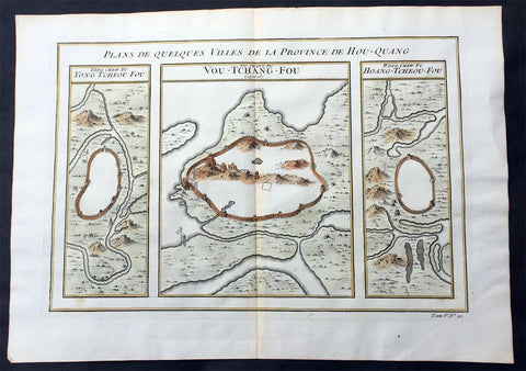
1755 Prevost Antique Map of Wuhan in Hubei, China - Huangzhou & Hoang-Tcheou-Fou
- Title: Plans De Quelques VIlles De La Province de Hou-Quang; Yong Tcheou Fou; Vou-Tchang-Fou; Hoang-Tcheou-Fou
- Date: 1755
- Size: 14in x 10in (355mm x 255mm)
- Ref: 25540
- Condition : (A+) Fine Condition
Description:
This fine, original copper-plate engraved antique map a birds-eye view of three walled cities of the central Chinese province of Hubei, Huangzhou, Wuhan & Hoang-Tcheou-Fou, on the Yangtze River, by Jakob van Schley in 1755 was published in Antoine François Prevosts 15 volumes of Histoire Generale des Voyageswritten by Prevost & other authors between 1746-1790.
Hubei or Hou-Quang is a province located in central China. Hubei means north of the lake, referring to its position north of Dongting Lake. The provincial capital is Wuhan, a major transportation thoroughfare and the political, cultural, and economic hub of Central China.
Hubei is an ancient name associated with the eastern part of the province since the Qin dynasty, after the powerful State of Chu that existed here during the Eastern Zhou dynasty. It borders Henan to the north, Anhui to the east, Jiangxito the southeast, Hunan to the south, Chongqing to the west, and Shaanxi to the northwest. The high-profile Three Gorges Dam is located at Yichang, in the west of the province.
Below is a description of each city & excerts from Jean Baptiste Du Haldes Description Geographique, Historique, Chronologique, Politique, et Physique de l\'Empire de la Chine published in 1735 of each city.
1. Yong tcheou fou - Huangzhou District is an urban district of Huanggang, Hubei, China. Huangzhou was previously a separate city which administered a prefecture in its own right.
The Seventh City, Yong tcheou fou.
This city, the most Southern of the Province, is surrounded with Mountains, whose Verdure renders a very agreeable Prospect, and is situate on the Banks of a River, which not far from thence runs into the Siang kiang. The Water of this River is so clear and limpid, that in the deepest Places you may count the Stones and Flints that are at the Bottom : There grows plenty of Bamboos in some part of this District and in others the Lien hoa, with yellow Flowers : There are eight Cities in its Jurisdiction, one of the Second Order, and seven of the Third.
Besides these principal Cities, there are two of the Second Order, which are not subject to any Fou, or City of the First Order, and have each a Jurisdiction over other Cities : The first is called Tsin tcheou, and is on the Frontiers of the Province of Koei tcheou, it has in its District three Cities of the Third Order : The second is called Tching Tcheou, a very large and populous City, built between two Rivers ; five Cities of the Third Order are subject to it, all situated on the Frontiers of the City of Quang Tong : Tho\' this City is full of Mountains, yet they do not hinder its Cultivation.
2. Vou-Tchang-Fou - Wuhan - is the capital of Hubei province, China, and is the most populous city in Central China. It lies in the eastern Jianghan Plain at the intersection of the middle reaches of the Yangtze and Han rivers.
With a 3,500-year-long history, Wuhan is one of the most ancient and civilized metropolitan cities in China. During the Han dynasty, Hanyang became a fairly busy port. In the winter of 208/9, one of the most famous battles in Chinese history and a central event in the Romance of the Three Kingdoms—the Battle of Red Cliffs—took place in the vicinity of the cliffs near Wuhan. Around that time, walls were built to protect Hanyang (AD 206) and Wuchang (AD 223). The latter event marks the foundation of Wuhan. In AD 223, the Yellow Crane Tower was constructed on the Wuchang side of the Yangtze River. Cui Hao, a celebrated poet of the Tang dynasty, visited the building in the early 8th century; his poem made it the most celebrated building in southern China. The city has long been renowned as a center for the arts (especially poetry) and for intellectual studies. Under the Mongol rulers (Yuan dynasty), Wuchang was promoted to the status of provincial capital; by the dawn of the 18th century, Hankou had become one of China\'s top four most important towns of trade.
The First City, and Capital of the Province, Vou chang fou
This is both the Capital of the Province, and the North Part of it, called Hou pe, where resides the Tsong tou of both Parts of this Province , it has under its particular Jurisdiction one City of the Second , Order, and nine of the Third.
Vou chang is almost in the Centre of the Empire, and situate in a Place which may most easily communicate with the rest of the Provinces. This City joined to Han yang, from which it is separated only by the Breadth of the River Yang tse kiang, and the little River Han forms a Place the best Peopled, and of the greatest Resort in China ; one may compare the Extent of this City to Paris, and Han Tang to Lyons, or Rouen: Add to this, an incredible Number of Barks of all Sizes, which lie some in one River, some in the other, for the length of French Leagues, to the number of eight or ten thousand Vessels, among which there are hundreds every way as large as the most part of those that lie at Nantz. Certainly, if one considers nothing else but this Forest of Masts which are upon the fine River Yang tse Kiang, about a League broad in this Place, tho\' it is 150 Leagues from the Sea, and deep enough for the greatest Vessels, it will justly raise our Wonder; but when one gains the Top of any Ascent, and discovers such a vast Extent of Ground covered with Houses, we should scarcely believe our won eyes, or at least must think it the finest Sight in the World.
One may judge, by the Number of Rivers and Lakes with which this Province is watered, how fruitful it is, and how easily the Trading with the rest of the Empire, by means of the great River Yang tse Kiang, must needs inrich it.
What is farther worthy of Observation, is the fine Cristal which is dug out of the Mountains, the plentiful Crops of the best Tea, and the extraordinary Demand for Bamboo Paper, which is manufactured here.
3. Hoang tcheou fou - The Eighth City.
The Situation of this City is on the Banks of the River Yang tse kiang ; its small distance from the Capital, and the Number of Lakes which surround it, render it a most agreeable Place for Habitation ; it is extremely well peopled, and for Trade gives place to few other Cities. There come there daily a surprising Number of Barks, loaded with all forts of Merchandize.
The whole District is admirably well cultivated, I and agreeably diversified by the Rivers and Brooks that Water it, as well as by the Mountains which bound it on the North ; some of these Mountains are covered with Trees, which are of great service to the Inhabitants ; there are also Fountains, which have the Property of giving Tea a delicious Taste.
There are taken in the River near the City great Numbers of Tortoises, some great, some small, which the Nobility keep in their Gardens for Diversion, and also at their Pleasure-Houses. They make excellent Arrack, which is very strong, and takes Fire in an Instant, and hath no bad Smell ; there are also very good Chestnuts, and very large. Its District: contains nine Cities, one of the Second Order, and eight of the Third. The South Part of the Province of Hou quang.
General Definitions:
Paper thickness and quality: - Heavy and stable
Paper color : - off white
Age of map color: - Early
Colors used: - Yellow, green, orange
General color appearance: - Authentic
Paper size: - 14in x 10in (355mm x 255mm)
Plate size: - 12in x 8in (305mm x 205mm)
Margins: - Min 1/2in (12mm)
Imperfections:
Margins: - None
Plate area: - None
Verso: - None
Background:
One of Antoine Francois Prevosts monumental undertakings was his history of exploration & discovery in 15 volumes titledHistoire Générale des Voyages written between 1746-1759 and was extended to 20 volumes after his death by various authors.
The 20 volumes cover the early explorations & discoveries on 3 continents: Africa (v. 1-5), Asia (v. 5-11), and America (v. 12-15) with material on the finding of the French, English, Dutch, and Portugese.
A number of notable cartographers and engravers contributed to the copper plate maps and views to the 20 volumes including Nicolas Bellin, Jan Schley, Chedel, Franc Aveline, Fessard, and many others.
The African volumes cover primarily coastal countries of West, Southern, and Eastern Africa, plus the Congo, Madagascar, Arabia and the Persian Gulf areas.
The Asian volumes cover China, Korea, Tibet, Japan, Philippines, and countries bordering the Indian Ocean.
Volume 11 includes Australia and Antarctica.
Volumes 12-15 cover voyages and discoveries in America, including the East Indies, South, Central and North America.
Volumes 16-20 include supplement volumes & tables along with continuation of voyages and discoveries in Russia, Northern Europe, America, Asia & Australia.
Jakob van der Schley aka Jakob van Schley (1715 - 1779) was a Dutch draughtsman and engraver. He studied under Bernard Picart (1673-1733) whose style he subsequently copied. His main interests were engraving portraits and producing illustrations for \\\"La Vie de Marianne\\\" by Pierre Carlet de Chamblain de Marivaux (1688-1763) published in The Hague between 1735 and 1747.
He also engraved the frontispieces for a 15-volume edition of the complete works of Pierre de Brantôme (1540-1614), \\\"Oeuvres du seigneur de Brantôme\\\", published in The Hague in 1740.
He is also responsible for most of the plates in the Hague edition of Prévosts Histoire générale des voyages. (Ref: Tooley; M&B)
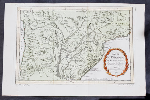
1756 Bellin Antique Map of Paraguay & Brazil, South America
- Title: Carte Du Paraguay...1756
-
Date: 1756
Condition : (A+) Fine Condition - Ref: 60939
- Size: 15in x 10in (380mm x 255mm)
Description:
This fine, original copper-plate engraved antique map of Paraguay South America, by Jacques Nicolas Bellin in 1756 was published in Antoine François Prevosts 15 volumes of Histoire Generale des Voyages written by Prevost & other authors between 1746-1790.
The first Europeansto explore the country were Spanish explorers in 1516. The Spanish explorer Juan de Salazar de Espinosa founded the settlement of Asunción on 15 August 1537. The city eventually became the center of a Spanish colonial province of Paraguay.
An attempt to create an autonomous Christian Indian nation was undertaken by Jesuit missions and settlements in this part of South America in the eighteenth century, which included portions of Uruguay, Argentina, and Brazil. They developed Jesuit reductions to bring Guarani populations together at Spanish missions and protect them from virtual slavery by Spanish settlers and Portuguese slave raiders, the Bandeirantes. In addition to seeking their conversion to Christianity. Catholicism in Paraguay was influenced by the indigenous peoples; the syncretic religion has absorbed native elements. The reducciones flourished in eastern Paraguay for about 150 years, until the expulsion of the Jesuits by the Spanish Crown in 1767. The ruins of two 18th-century Jesuit Missions of La Santísima Trinidad de Paraná and Jesús de Tavarangue have been designated as World Heritage Sites by UNESCO.
In western Paraguay Spanish settlement and Christianity were strongly resisted by the nomadic Guaycuru and other nomads from the 16th century onward. Most of these peoples were absorbed into the mestizo population in the 18th and 19th centuries.
General Definitions:
Paper thickness and quality: - Heavy and stable
Paper color : - off white
Age of map color: - Early
Colors used: - Yellow, green, red
General color appearance: - Authentic
Paper size: - 15in x 10in (380mm x 255mm)
Plate size: - 13in x 8 1/2in (330mm x 215mm)
Margins: - Min 1/2in (12mm)
Imperfections:
Margins: - None
Plate area: - Folds as issued
Verso: - None
Background:
One of Antoine Francois Prevosts monumental undertakings was his history of exploration & discovery in 15 volumes titledHistoire Générale des Voyages written between 1746-1759 and was extended to 20 volumes after his death by various authors.
The 20 volumes cover the early explorations & discoveries on 3 continents: Africa (v. 1-5), Asia (v. 5-11), and America (v. 12-15) with material on the finding of the French, English, Dutch, and Portugese.
A number of notable cartographers and engravers contributed to the copper plate maps and views to the 20 volumes including Nicolas Bellin, Jan Schley, Chedel, Franc Aveline, Fessard, and many others.
The African volumes cover primarily coastal countries of West, Southern, and Eastern Africa, plus the Congo, Madagascar, Arabia and the Persian Gulf areas.
The Asian volumes cover China, Korea, Tibet, Japan, Philippines, and countries bordering the Indian Ocean.
Volume 11 includes Australia and Antarctica.
Volumes 12-15 cover voyages and discoveries in America, including the East Indies, South, Central and North America.
Volumes 16-20 include supplement volumes & tables along with continuation of voyages and discoveries in Russia, Northern Europe, America, Asia & Australia.
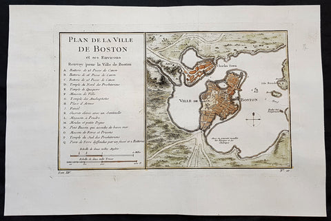
1756 J N Bellin Antique Map of The City of Boston & Charlestown
Antique Map
- Title : Plan de la Ville De Boston et ses Environs
- Ref #: 93417
- Size: 14 1/2in x 9 1/2in (350mm x 240mm)
- Date : 1756
- Condition: (A+) Fine Condition
Description:
This original hand coloured copper plate engraved antique map of Boston and surrounding areas - one of the earliest obtainable maps of the city - by Jacques Nicholas Bellin in 1756 - was published in the French edition of Antoine-François Prevosts 20 volume L Histoire Generale des Voyages published by Pierre de Hondt in the Hague between 1747 & 1785.
Beautiful map with great street and building detail in both Boston and Charlestown, showing parts of Ronde Isle and the mainland. Important buildings and areas identified in an idex at the left of the map. Including three cannon batteries, the Presbyterian Church, the Quaker temple, the Anabaptist Church, the City Hall, the Armory, Faneuil Hall (Spelled Fanal), etc. (Ref: Tooley; M&B)
General Definitions:
Paper thickness and quality: - Heavy and stable
Paper color : - off white
Age of map color: - Early
Colors used: - Yellow, green, blue, pink
General color appearance: - Authentic
Paper size: - 14 1/2in x 9 1/2in (350mm x 240mm)
Plate size: - 11 1/2in x 7 1/2in (285mm x 190mm)
Margins: - Min 1in (25mm)
Imperfections:
Margins: - None
Plate area: - Folds as issued
Verso: - None
Background:
Boston is the capital city and most populous municipality of the Commonwealth of Massachusetts in the United States.
Boston is one of the oldest cities in the United States, founded on the Shawmut Peninsula in 1630 by Puritan settlers from England. It was the scene of several key events of the American Revolution, such as the Boston Massacre, the Boston Tea Party, the Battle of Bunker Hill, and the Siege of Boston. Upon U.S. independence from Great Britain, it continued to be an important port and manufacturing hub as well as a center for education and culture.
In the 1820s, Boston\\\\\\\\\\\\\\\'s population grew rapidly, and the city\\\\\\\\\\\\\\\'s ethnic composition changed dramatically with the first wave of European immigrants. Irish immigrants dominated the first wave of newcomers during this period, especially following the Irish Potato Famine; by 1850, about 35,000 Irish lived in Boston. In the latter half of the 19th century, the city saw increasing numbers of Irish, Germans, Lebanese, Syrians, French Canadians, and Russian and Polish Jews settling in the city. By the end of the 19th century, Boston\\\\\\\\\\\\\\\'s core neighborhoods had become enclaves of ethnically distinct immigrants. Italians inhabited the North End, Irish dominated South Boston and Charlestown, and Russian Jews lived in the West End. Irish and Italian immigrants brought with them Roman Catholicism. Currently, Catholics make up Boston\\\\\\\\\\\\\\\'s largest religious community and the Irish have played a major role in Boston politics since the early 20th century; prominent figures include the Kennedys, Tip O\\\\\\\\\\\\\\\'Neill, and John F. Fitzgerald.
Between 1631 and 1890, the city tripled its area through land reclamation by filling in marshes, mud flats, and gaps between wharves along the waterfront. The largest reclamation efforts took place during the 19th century; beginning in 1807, the crown of Beacon Hill was used to fill in a 50-acre mill pond that later became the Haymarket Square area. The present-day State House sits atop this lowered Beacon Hill. Reclamation projects in the middle of the century created significant parts of the South End, the West End, the Financial District, and Chinatown.
After the Great Boston Fire of 1872, workers used building rubble as landfill along the downtown waterfront. During the mid- to-late 19th century, workers filled almost 600 acres of brackish Charles River marshlands west of Boston Common with gravel brought by rail from the hills of Needham Heights. The city annexed the adjacent towns of South Boston (1804), East Boston (1836), Roxbury (1868), Dorchester (including present day Mattapan and a portion of South Boston) (1870), Brighton (including present day Allston) (1874), West Roxbury (including present day Jamaica Plain and Roslindale) (1874), Charlestown (1874), and Hyde Park (1912). Other proposals were unsuccessful for the annexation of Brookline, Cambridge and Chelsea.
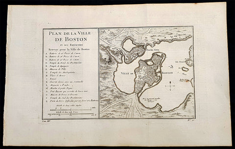
1756 Nicolas Bellin Antique Map of the City of Boston & Charlestown, Harbor
Antique Map
- Title : Plan De La Ville De Boston Et Ses Environs Renvoy pour la Ville de Boston...
- Date : 1756
- Condition: (A+) Fine Condition
- Ref: 93360
- Size: 16in x 10in (405mm x 255mm)
Description:
This original antique map of Boston and surrounding areas - one of the earliest obtainable maps of the city - by Jacques Nicholas Bellin in 1756 - was published in the French edition of Antoine-François Prevosts 20 volume L Histoire Generale des Voyages published by Pierre de Hondt in the Hague between 1747 & 1785.
Beautiful map with great street and building detail in both Boston and Charlestown, showing parts of Ronde Isle and the mainland. Important buildings and areas identified in an idex at the left of the map. Including three cannon batteries, the Presbyterian Church, the Quaker temple, the Anabaptist Church, the City Hall, the Armory, Faneuil Hall (Spelled Fanal), etc. (Ref: Tooley; M&B)
General Definitions:
Paper thickness and quality: - Heavy and stable
Paper color : - off white
Age of map color: -
Colors used: -
General color appearance: -
Paper size: - 16in x 10in (405mm x 255mm)
Plate size: - 11 1/2in x 7 1/2in (285mm x 190mm)
Margins: - Min 1/2in (12mm)
Imperfections:
Margins: - None
Plate area: - Folds as issued
Verso: - None
Background:
Boston is the capital city and most populous municipality of the Commonwealth of Massachusetts in the United States.
Boston is one of the oldest cities in the United States, founded on the Shawmut Peninsula in 1630 by Puritan settlers from England. It was the scene of several key events of the American Revolution, such as the Boston Massacre, the Boston Tea Party, the Battle of Bunker Hill, and the Siege of Boston. Upon U.S. independence from Great Britain, it continued to be an important port and manufacturing hub as well as a center for education and culture.
In the 1820s, Boston\\\'s population grew rapidly, and the city\\\'s ethnic composition changed dramatically with the first wave of European immigrants. Irish immigrants dominated the first wave of newcomers during this period, especially following the Irish Potato Famine; by 1850, about 35,000 Irish lived in Boston. In the latter half of the 19th century, the city saw increasing numbers of Irish, Germans, Lebanese, Syrians, French Canadians, and Russian and Polish Jews settling in the city. By the end of the 19th century, Boston\\\'s core neighborhoods had become enclaves of ethnically distinct immigrants. Italians inhabited the North End, Irish dominated South Boston and Charlestown, and Russian Jews lived in the West End. Irish and Italian immigrants brought with them Roman Catholicism. Currently, Catholics make up Boston\\\'s largest religious community and the Irish have played a major role in Boston politics since the early 20th century; prominent figures include the Kennedys, Tip O\\\'Neill, and John F. Fitzgerald.
Between 1631 and 1890, the city tripled its area through land reclamation by filling in marshes, mud flats, and gaps between wharves along the waterfront. The largest reclamation efforts took place during the 19th century; beginning in 1807, the crown of Beacon Hill was used to fill in a 50-acre mill pond that later became the Haymarket Square area. The present-day State House sits atop this lowered Beacon Hill. Reclamation projects in the middle of the century created significant parts of the South End, the West End, the Financial District, and Chinatown.
After the Great Boston Fire of 1872, workers used building rubble as landfill along the downtown waterfront. During the mid- to-late 19th century, workers filled almost 600 acres of brackish Charles River marshlands west of Boston Common with gravel brought by rail from the hills of Needham Heights. The city annexed the adjacent towns of South Boston (1804), East Boston (1836), Roxbury (1868), Dorchester (including present day Mattapan and a portion of South Boston) (1870), Brighton (including present day Allston) (1874), West Roxbury (including present day Jamaica Plain and Roslindale) (1874), Charlestown (1874), and Hyde Park (1912). Other proposals were unsuccessful for the annexation of Brookline, Cambridge and Chelsea.
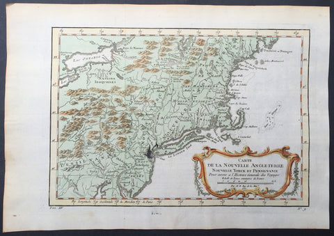
1757 Bellin Antique Map of New England, New York, New Jersey, Pennsylvania
- Title : Carte De La Nouvelle Angleterre...Par M B. 1757
- Ref #: 61097
- Size: 14 1/2in x 10in (370mm x 255mm)
- Date : 1757
- Condition: (A+) Fine Condition
Description:
This beautifully hand coloured original antique map of New England & the NE corridor of the US from Pennsylvania to Maine was engraved in 1757 - the date is engraved in the title - and was published in the 1757 French edition of Antoine-François Prevosts 20 volume L`Histoire Generale des Voyages published by Pierre de Hondt in the Hague between 1747 & 1785.
Antoine François Prévost d'Exiles 1697 - 1763, usually known simply as the Abbé Prévost, was a French author and novelist. (Ref: Tooley; M&B)
General Description:
Paper thickness and quality: - Heavy and stable
Paper color: - white
Age of map color: - Early
Colors used: - Green, yellow, red
General color appearance: - Authentic
Paper size: - 14 1/2in x 10in (370mm x 255mm)
Plate size: - 12 1/2in x 9in (320mm x 225mm)
Margins: - min. 1in (25mm)
Imperfections:
Margins: - None
Plate area: - Folds as issued, ink bleed from original plate
Verso: - None
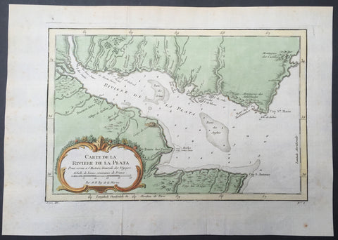
1757 Bellin Antique Map of Rio de la Plata, River Plate, Buenos Aires, Argentina
- Title : Carte de la Riviere de la Plata...
- Ref #: 61103
- Size: 10in x 7 1/2in (255mm x 190mm)
- Date : 1757
- Condition: (A+) Fine Condition
Description:
This fine, original copper-plate engraved antique map of the Río de la Plata of Argentina, by Jacques Nicolas Bellin in 1757 was published in Antoine François Prevosts 15 volumes of Histoire Generale des Voyageswritten by Prevost & other authors between 1746-1790.
The Río de la Plata River Plate in British English and La Plata River (occasionally Plata River) in other English-speaking countries — is the estuary formed by the confluence of the Uruguay and the Paraná rivers. It empties into the Atlantic Ocean, forming a funnel-shaped indentation on the southeastern coastline of South America. Depending on the geographer, the Río de la Plata may be considered a river, an estuary, a gulf or a marginal sea. For those who consider it a river—as is the case mostly in Argentina—it would be the widest river in the world, with a maximum width of about 220 kilometres.
The Río de la Plata was first explored by the Portuguese in 1512–13. The Spanish first explored it in 1516, when the navigator Juan Díaz de Solís traversed it during his search for a passage between the Atlantic and the Pacific Oceans, calling it the Mar Dulce, or \"freshwater sea.\" The Portuguese navigator Ferdinand Magellan briefly explored the estuary in 1520 before his expedition continued its circumnavigation, and in 1521 Cristóvão Jacques also explored the Plate River estuary and ascended the Parana River for the first time, entering it for about 23 leagues (around 140 km) to near the present city of Rosario.[12] The area was also visited by Francis Drake\'s fleet in early 1578, in the early stages of his circumnavigation.
Explorer Sebastian Cabot made a detailed study of the river and its tributaries and gave it its modern name. He explored the Paraná and Uruguay rivers between 1526 and 1529, ascending the Paraná as far as the present-day city of Asunción, and also explored up the Paraguay River. Cabot acquired silver trinkets trading with the Guaraní near today\'s Asunción, and these objects (together with legends of a \"Sierra de la Plata\" in the South American interior brought back by earlier explorers) inspired him to rename the river \"Río de la Plata\" (\"River of Silver\").
The first European colony was the city of Buenos Aires, founded by Pedro de Mendoza on 2 February 1536. This settlement, however, was quickly abandoned; the failure to establish a settlement on the estuary led to explorations upriver and the founding of Asunción in 1537. Buenos Aires was subsequently refounded by Juan de Garay on 11 June 1580.
The city of Buenos Aires sits along the southern coast of the Río de la Plata.
During the colonial era the Río de la Plata was made the center of the Governorate of the Río de la Plata, but the region\'s development was largely neglected by the Spanish Empire until the 1760s, when Portugal and Britain threatened to expand into the estuary. The governorate was elevated to form the Viceroyalty of the Río de la Plata in 1776. In 1806 and 1807 the river was the scene of an important British invasion that aimed to occupy the area.
General Definitions:
Paper thickness and quality: - Heavy and stable
Paper color : - off white
Age of map color: - Early
Colors used: - Green, yellow, orange
General color appearance: - Authentic
Paper size: - 14in x 10in (355mm x 255mm)
Plate size: - 12in x 8in (305mm x 205mm)
Margins: - Min 1/2in (12mm)
Imperfections:
Margins: - Light age toning in margins
Plate area: - Folds as issued
Verso: - None
Background:
One of Antoine Francois Prevosts monumental undertakings was his history of exploration & discovery in 15 volumes titledHistoire Générale des Voyages written between 1746-1759 and was extended to 20 volumes after his death by various authors.
The 20 volumes cover the early explorations & discoveries on 3 continents: Africa (v. 1-5), Asia (v. 5-11), and America (v. 12-15) with material on the finding of the French, English, Dutch, and Portugese.
A number of notable cartographers and engravers contributed to the copper plate maps and views to the 20 volumes including Nicolas Bellin, Jan Schley, Chedel, Franc Aveline, Fessard, and many others.
The African volumes cover primarily coastal countries of West, Southern, and Eastern Africa, plus the Congo, Madagascar, Arabia and the Persian Gulf areas.
The Asian volumes cover China, Korea, Tibet, Japan, Philippines, and countries bordering the Indian Ocean.
Volume 11 includes Australia and Antarctica.
Volumes 12-15 cover voyages and discoveries in America, including the East Indies, South, Central and North America.
Volumes 16-20 include supplement volumes & tables along with continuation of voyages and discoveries in Russia, Northern Europe, America, Asia & Australia.
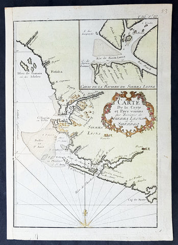
1757 Bellin Antique Map of Sierra Leone & Sherbro Rivers of Sierra Leone, Africa
- Title : Carte de la Coste et Pays voisins das Rivieres des Sierra Leona et de Sherbro
- Size: 10in x 7in (255mm x 180mm)
- Ref #: 21174
- Date : 1757
- Condition: (A) Very Good Condition
Description:
This fine, original copper-plate engraved antique map of the coast and river mouth of the Sierra Leone & the Sherbro Rivers in Sierrra Leone West Africa by Nicolas Bellin in 1757 was published in Antoine François Prevosts 15 volumes of Histoire Generale des Voyageswritten by Prevost & other authors between 1746-1790.
The Sierra Leone River is a river estuary on the Atlantic Ocean in Western Sierra Leone. It is formed by the Bankasoka River and Rokel River and is between 4 and 10 miles wide (6–16 km) and 25 miles (40 km) long. It holds the major ports of Queen Elizabeth II Quay and Pepel. The estuary is also important for shipping. It is the largest natural harbour in the African continent. Several islands, including Tasso Island (the largest), Tombo Island, and the historically important Bunce Island, are located in the estuary.
Sherbro Island is in the Atlantic Ocean, located in Bonthe District off the Southern Province of Sierra Leone. The Sherbro people make up by far the largest ethnic group in the island.
General Definitions:
Paper thickness and quality: - Heavy and stable
Paper color : - off white
Age of map color: - Early
Colors used: - Yellow, green
General color appearance: - Authentic
Paper size: - 10in x 7in (255mm x 180mm)
Plate size: - 9in x 6 1/2in (250mm x 165mm)
Margins: - Min 1/2in (12mm)
Imperfections:
Margins: - None
Plate area: - Repair to left of image
Verso: - Repair as noted
Background:
One of Antoine Francois Prevosts monumental undertakings was his history of exploration & discovery in 15 volumes titledHistoire Générale des Voyages written between 1746-1759 and was extended to 20 volumes after his death by various authors.
The 20 volumes cover the early explorations & discoveries on 3 continents: Africa (v. 1-5), Asia (v. 5-11), and America (v. 12-15) with material on the finding of the French, English, Dutch, and Portugese.
A number of notable cartographers and engravers contributed to the copper plate maps and views to the 20 volumes including Nicolas Bellin, Jan Schley, Chedel, Franc Aveline, Fessard, and many others.
The African volumes cover primarily coastal countries of West, Southern, and Eastern Africa, plus the Congo, Madagascar, Arabia and the Persian Gulf areas.
The Asian volumes cover China, Korea, Tibet, Japan, Philippines, and countries bordering the Indian Ocean.
Volume 11 includes Australia and Antarctica.
Volumes 12-15 cover voyages and discoveries in America, including the East Indies, South, Central and North America.
Volumes 16-20 include supplement volumes & tables along with continuation of voyages and discoveries in Russia, Northern Europe, America, Asia & Australia.
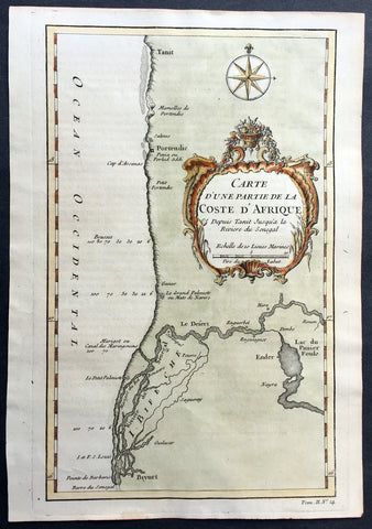
1757 Bellin Antique Map of West Africa South Senegal - Saloum Delta, Nat. Park
- Title : Carte D Une Partie de la Coste D Afrique Depuis Tanit Jusqua la Riviere du Senegal
- Size: 10in x 7in (255mm x 180mm)
- Ref #: 25792
- Date : 1757
- Condition: (A+) Fine Condition
Description:
This fine original copper-plate engraved antique map of Southern Senegal in West Africa including what is today part of the Saloum National Park in the Saloum Delta by Jacques Nicolas Bellin was published in 1757 in Antoine François Prevosts 15 volumes of Histoire Generale des Voyages written by Prevost & other authors between 1746-1790.
General Definitions:
Paper thickness and quality: - Heavy and stable
Paper color : - off white
Age of map color: - Early
Colors used: - Green, yellow, orange
General color appearance: - Authentic
Paper size: - 10in x 7in (255mm x 180mm)
Plate size: - 10in x 7in (255mm x 180mm)
Margins: - Min 1/2in (12mm)
Imperfections:
Margins: - None
Plate area: - None
Verso: - None
Background:
One of Antoine Francois Prevosts monumental undertakings was his history of exploration & discovery in 15 volumes titledHistoire Générale des Voyages written between 1746-1759 and was extended to 20 volumes after his death by various authors.
The 20 volumes cover the early explorations & discoveries on 3 continents: Africa (v. 1-5), Asia (v. 5-11), and America (v. 12-15) with material on the finding of the French, English, Dutch, and Portugese.
A number of notable cartographers and engravers contributed to the copper plate maps and views to the 20 volumes including Nicolas Bellin, Jan Schley, Chedel, Franc Aveline, Fessard, and many others.
The African volumes cover primarily coastal countries of West, Southern, and Eastern Africa, plus the Congo, Madagascar, Arabia and the Persian Gulf areas.
The Asian volumes cover China, Korea, Tibet, Japan, Philippines, and countries bordering the Indian Ocean.
Volume 11 includes Australia and Antarctica.
Volumes 12-15 cover voyages and discoveries in America, including the East Indies, South, Central and North America.
Volumes 16-20 include supplement volumes & tables along with continuation of voyages and discoveries in Russia, Northern Europe, America, Asia & Australia.
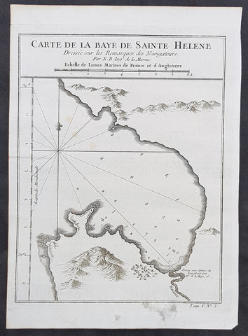
1757 Bellin Antique Map St Helena Bay, Western Cape South Africa - Vasco da Gama
- Title : Carte de la Baye de Sainte Helene
- Size: 10in x 7 1/2in (255mm x 190mm)
- Ref #: 25783
- Date : 1757
- Condition: (A+) Fine Condition
Description:
This fine original copper-plate engraved antique map of St Helena Bay in Western Cape South Africa by Jacques Nicolas Bellin was published in 1757 in Antoine François Prevosts 15 volumes of Histoire Generale des Voyages written by Prevost & other authors between 1746-1790.
Historically, Saint Helena Bay is the location where Vasco da Gama, first set foot in South Africa. The date of this event was recorded as November 7, 1497.
The bay was named Bahia de Santa Helena (Portuguese for its current name) after Saint Helena a devout, influential Christian and mother of Constantine I. This location was also the first setting of a battle between the indigenous Khoikhoi people and early European explorers.
General Definitions:
Paper thickness and quality: - Heavy and stable
Paper color : - off white
Age of map color: -
Colors used: -
General color appearance: -
Paper size: - 10in x 7 1/2in (255mm x 190mm)
Plate size: - 10in x 7 1/2in (255mm x 190mm)
Margins: - Min 1/2in (12mm)
Imperfections:
Margins: - None
Plate area: - None
Verso: - None
Background:
One of Antoine Francois Prevosts monumental undertakings was his history of exploration & discovery in 15 volumes titledHistoire Générale des Voyages written between 1746-1759 and was extended to 20 volumes after his death by various authors.
The 20 volumes cover the early explorations & discoveries on 3 continents: Africa (v. 1-5), Asia (v. 5-11), and America (v. 12-15) with material on the finding of the French, English, Dutch, and Portugese.
A number of notable cartographers and engravers contributed to the copper plate maps and views to the 20 volumes including Nicolas Bellin, Jan Schley, Chedel, Franc Aveline, Fessard, and many others.
The African volumes cover primarily coastal countries of West, Southern, and Eastern Africa, plus the Congo, Madagascar, Arabia and the Persian Gulf areas.
The Asian volumes cover China, Korea, Tibet, Japan, Philippines, and countries bordering the Indian Ocean.
Volume 11 includes Australia and Antarctica.
Volumes 12-15 cover voyages and discoveries in America, including the East Indies, South, Central and North America.
Volumes 16-20 include supplement volumes & tables along with continuation of voyages and discoveries in Russia, Northern Europe, America, Asia & Australia.
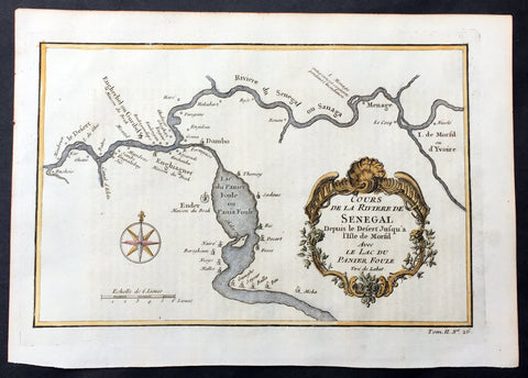
1757 Bellin Antique Map The Senegal River, Bethio & N Dombo, Senegal West Africa
- Title : Cours de la Riviere de Senegal Depuis le Desert Jusqu a Isle de Morsil...
- Size: 10in x 7in (255mm x 180mm)
- Ref #: 25785
- Date : 1757
- Condition: (A+) Fine Condition
Description:
This fine, original copper-plate engraved antique map of the Senegal River in the Bethio & N Dombo regions of Northern Senegal and Mauritania in West Africa by Nicolas Bellin in 1757 was published in Antoine François Prevosts 15 volumes of Histoire Generale des Voyages written by Prevost & other authors between 1746-1790.
The Senegal River is a 1,086 km (675 mi) long river in West Africa that forms the border between Senegal and Mauritania.
General Definitions:
Paper thickness and quality: - Heavy and stable
Paper color : - off white
Age of map color: - Early
Colors used: - Yellow, green
General color appearance: - Authentic
Paper size: - 10in x 7in (255mm x 180mm)
Plate size: - 9in x 6 1/2in (250mm x 165mm)
Margins: - Min 1/2in (12mm)
Imperfections:
Margins: - None
Plate area: - None
Verso: - None
Background:
One of Antoine Francois Prevosts monumental undertakings was his history of exploration & discovery in 15 volumes titledHistoire Générale des Voyages written between 1746-1759 and was extended to 20 volumes after his death by various authors.
The 20 volumes cover the early explorations & discoveries on 3 continents: Africa (v. 1-5), Asia (v. 5-11), and America (v. 12-15) with material on the finding of the French, English, Dutch, and Portugese.
A number of notable cartographers and engravers contributed to the copper plate maps and views to the 20 volumes including Nicolas Bellin, Jan Schley, Chedel, Franc Aveline, Fessard, and many others.
The African volumes cover primarily coastal countries of West, Southern, and Eastern Africa, plus the Congo, Madagascar, Arabia and the Persian Gulf areas.
The Asian volumes cover China, Korea, Tibet, Japan, Philippines, and countries bordering the Indian Ocean.
Volume 11 includes Australia and Antarctica.
Volumes 12-15 cover voyages and discoveries in America, including the East Indies, South, Central and North America.
Volumes 16-20 include supplement volumes & tables along with continuation of voyages and discoveries in Russia, Northern Europe, America, Asia & Australia.
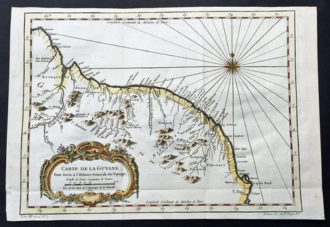
1757 Bellin Large Antique Map of Guyana, South America
- Title: Carte de la Guyana...1757
- Date: 1757
- Condition : (A+) Fine Condition
- Ref: 60940
- Size: 15in x 10in (380mm x 255mm)
Description:
This fine, original copper-plate engraved antique map of Guyana, South America by Jacques Nicolas Bellin was engraved in 1757 - dated - and was published in Antoine François Prevosts 15 volumes of Histoire Generale des Voyages written by Prevost & other authors between 1746-1790.
Guyana officially the Co-operative Republic of Guyana, is a sovereign state on the northern mainland of South America. It is, however, often considered part of the Caribbean region because of its strong cultural, historical, and political ties with other Anglo Caribbean countries and the Caribbean Community (CARICOM). Guyana is bordered by the Atlantic Ocean to the north, Brazil to the south and southwest, Suriname to the east and Venezuela to the west.
There are nine indigenous tribes residing in Guyana: the Wai Wai, Macushi, Patamona, Lokono, Kalina, Wapishana, Pemon, Akawaio and Warao. Historically the Lokono and Kalina tribes dominated Guyana. Although Christopher Columbus sighted Guyana during his third voyage (in 1498), and Sir Walter Raleigh wrote an account of its discovery in 1596, the Dutch were the first to establish colonies: Essequibo (1616), Berbice (1627), and Demerara (1752). After the British assumed control in 1796, the Dutch formally ceded the area in 1814. In 1831 the three separate colonies became a single British colony known as British Guiana.
General Definitions:
Paper thickness and quality: - Heavy and stable
Paper color : - off white
Age of map color: - Early
Colors used: - Green, yellow, orange
General color appearance: - Authentic
Paper size: - 15in x 10in (380mm x 255mm)
Plate size: - 13in x 9 1/2in (330mm x 245mm)
Margins: - Min 1/2in (12mm)
Imperfections:
Margins: - None
Plate area: - Folds as issued
Verso: - None
One of Antoine Francois Prevosts monumental undertakings was his history of exploration & discovery in 15 volumes titledHistoire Générale des Voyages written between 1746-1759 and was extended to 20 volumes after his death by various authors.
The 20 volumes cover the early explorations & discoveries on 3 continents: Africa (v. 1-5), Asia (v. 5-11), and America (v. 12-15) with material on the finding of the French, English, Dutch, and Portugese.
A number of notable cartographers and engravers contributed to the copper plate maps and views to the 20 volumes including Nicolas Bellin, Jan Schley, Chedel, Franc Aveline, Fessard, and many others.
The African volumes cover primarily coastal countries of West, Southern, and Eastern Africa, plus the Congo, Madagascar, Arabia and the Persian Gulf areas.
The Asian volumes cover China, Korea, Tibet, Japan, Philippines, and countries bordering the Indian Ocean.
Volume 11 includes Australia and Antarctica.
Volumes 12-15 cover voyages and discoveries in America, including the East Indies, South, Central and North America.
Volumes 16-20 include supplement volumes & tables along with continuation of voyages and discoveries in Russia, Northern Europe, America, Asia & Australia.
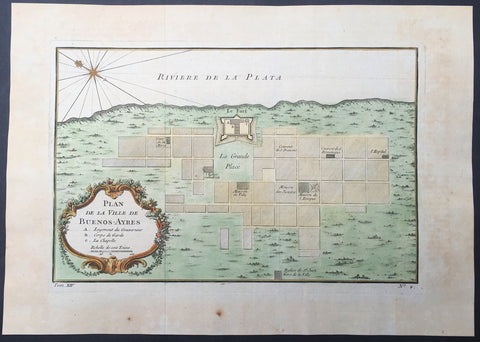
1757 Nicolas Bellin Antique Map, Plan of the City of Buenos Aires, Argentina
- Title : Plan De La Ville de Buenos - Ayres
- Ref #: 61102
- Size: 14in x 10in (355mm x 255mm)
- Date : 1757
- Condition: (A+) Fine Condition
Description:
This beautifully hand coloured original antique map* a plan of the Capital City of Argentina Buenos Aires by Jacques Nicolas Bellin was published in the 1757 French & Dutch edition of Antoine-François Prevosts 20 volume L`Histoire Generale des Voyages published by Pierre de Hondt in the Hague between 1747 & 1785.
Background: Seaman Juan Díaz de Solís, navigating in the name of Spain, was the first European to reach the Río de la Plata in 1516. His expedition was cut short when he was killed during an attack by the native Charrúa tribe in what is now Uruguay.
The city of Buenos Aires was first established as Ciudad de Nuestra Señora Santa María del Buen Ayre (literally "City of Our Lady Saint Mary of the Fair Winds") after Our Lady of Bonaria (Patroness Saint of Sardinia) on 2 February 1536 by a Spanish expedition led by Pedro de Mendoza. The settlement founded by Mendoza was located in what is today the San Telmo district of Buenos Aires, south of the city center.
More attacks by the indigenous people forced the settlers away, and in 1542 the site was abandoned. A second (and permanent) settlement was established in 11 June 1580 by Juan de Garay, who arrived by sailing down the Paraná River from Asunción (now the capital of Paraguay). He dubbed the settlement "Santísima Trinidad" and its port became "Puerto de Santa María de los Buenos Aires.
From its earliest days, Buenos Aires depended primarily on trade. During most of the 17th and 18th centuries, Spanish ships were menaced by pirates, so they developed a complex system where ships with military protection were dispatched to Central America, cross the land, from there to Lima, Peru and from it to the inner cities of the viceroyalty. Because of this, products took a very long time to arrive in Buenos Aires, and the taxes generated by the transport made them prohibitive. This scheme frustrated the traders of Buenos Aires, and a thriving contraband industry developed. This also instilled a deep resentment in porteños towards the Spanish authorities.
Sensing these feelings, Charles III of Spain progressively eased the trade restrictions and finally declared Buenos Aires an open port in the late 18th century. The capture of Porto Bello by British forces also fueled the need to foster commerce via the Atlantic route, to the detriment of Lima-based trade. One of his rulings was to split a region from the Viceroyalty of Perú and create instead the Viceroyalty of the Río de la Plata, with Buenos Aires as the capital. However, Charles's placating actions did not have the desired effect, and the porteños, some of them versed in the ideology of the French Revolution, became even more convinced of the need for independence from Spain. (Ref: Tooley; M&B)
General Description:
Paper thickness and quality: - Heavy and stable
Paper color: - off white
Age of map color: - Early
Colors used: - Yellow, green, red, brown.
General color appearance: - Authentic and fresh
Paper size: - 14in x 10in (355mm x 255mm)
Plate size: - 11 1/2in x 7 1/2in (290mm x 190mm)
Margins: - Min 1in (25mm)
Imperfections:
Margins: - Light age toning
Plate area: - Folds as issued
Verso: - None