Welcome to Classical Images!
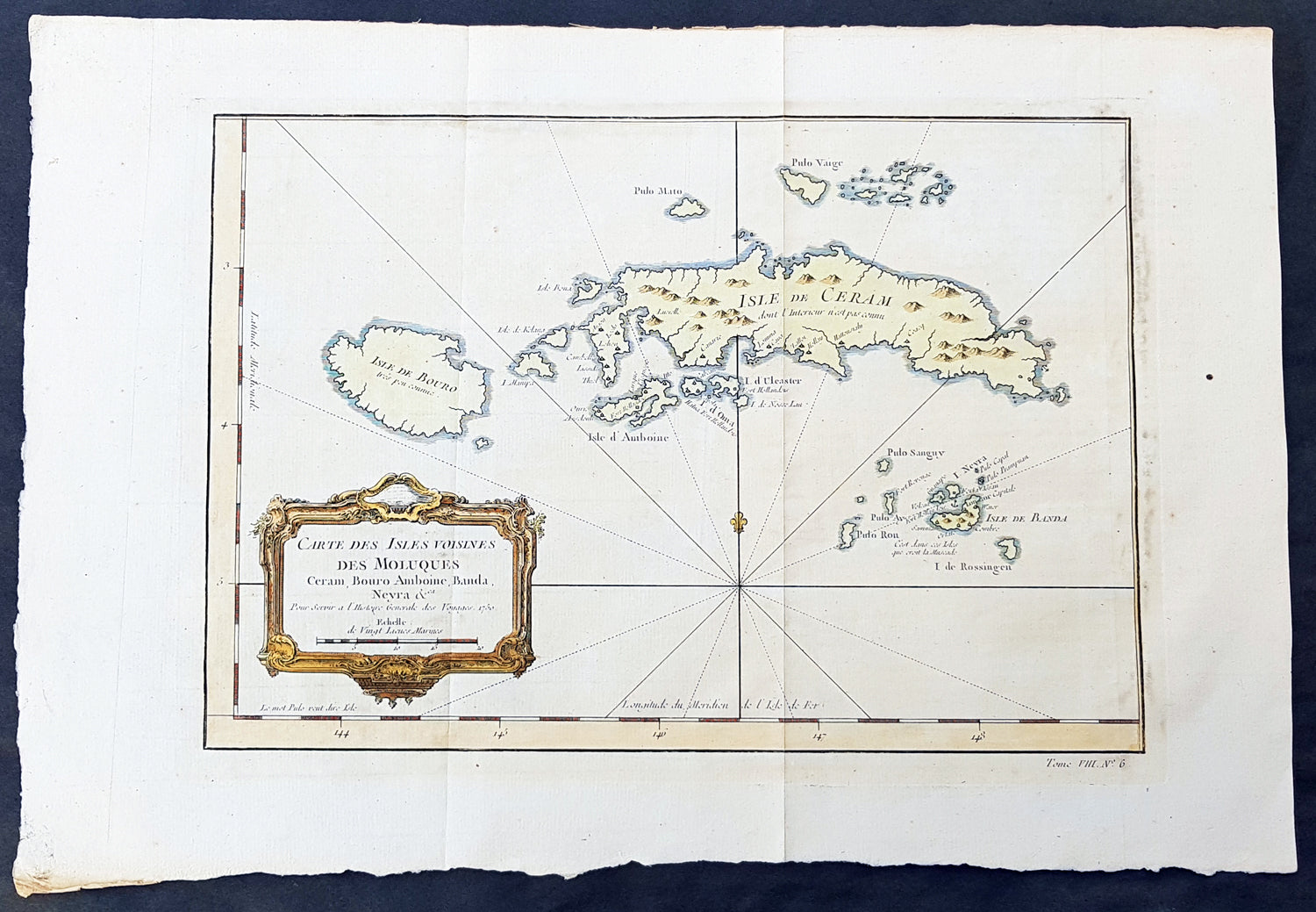
Description:This fine, original copper-plate engraved antique map of the Maluku or Moluccas Islands (Spice Islands) Indonesia by Jacques Nicolas Bellin in 1750 was published in Antoine François Prevosts 15 volumes of Histoire Generale des Voyages written by Prevost & other authors between 1746-1790.The Maluku Islands or the Moluccas are an archipelago within Banda Sea, Indonesia. Geographically they are located east of Sulawesi, west of New Guinea, and north and east of Timor.The islands were known as the Spice Islands due to the nutmeg, mace and cloves that were originally exclusively found there, and the presence of these sparked colonial interest from Europe in the 16th century.The most significant lasting effects of the Portuguese colonisation was the disruption and reorganization of the Southeast Asian trade, and in eastern Indonesia—including Maluku—the introduction of Christianity. The Portuguese had conquered the city state of Malacca in the early 16th century and their influence was most strongly felt in Maluku and other parts of eastern Indonesia. After the Portuguese annexed Malacca in August 1511, one Portuguese diary noted \'it is thirty years since they became Moors - giving a sense of the competition then taking place between Islamic and European influences in the region.Afonso de Albuquerque learned of the route to the Banda Islands and other \'Spice Islands\', and sent an exploratory expedition of three vessels under the command of António de Abreu, Simão Afonso Bisigudo and Francisco Serrão. On the return trip, Francisco Serrão was shipwrecked at Hitu island (northern Ambon) in 1512. There he established ties with the local ruler who was impressed with his martial skills. The rulers of the competing island states of Ternate and Tidore also sought Portuguese assistance and the newcomers were welcomed in the area as buyers of supplies and spices during a lull in the regional trade due to the temporary disruption of Javanese and Malay sailings to the area following the 1511 conflict in Malacca. The spice trade soon revived but the Portuguese would not be able to fully monopolize nor disrupt this trade.Allying himself with Ternate\'s ruler, Serrão constructed a fortress on that tiny island and served as the head of a mercenary band of Portuguese seamen under the service of one of the two local feuding sultans who controlled most of the spice trade. Both Serrão and Ferdinand Magellan, however, perished before they could meet one another.The Portuguese first landed in Ambon in 1513, but it only became the new centre for their activities in Maluku following the expulsion from Ternate. European power in the region was weak and Ternate became an expanding, fiercely Islamic and anti-European state under the rule of Sultan Baab Ullah (r. 1570–1583) and his son Sultan Said.Following Portuguese missionary work, there have been large Christian communities in eastern Indonesia through to contemporary times, which has contributed to a sense of shared interest with Europeans, particularly among the Ambonese. By the 1560s there were 10,000 Catholics in the area, mostly on Ambon, and by the 1590s there were 50,000 to 60,000. The central and southern parts of Maluku are populated by a majority of Christians.The Dutch arrived in 1599 and competed with the Portuguese in the area for trade.
General Definitions:Paper thickness and quality: - Heavy and stablePaper color : - off whiteAge of map color: - EarlyColors used: - Green, yellow, redGeneral color appearance: - AuthenticPaper size: - 16in x 10 1/2in (390mm x 265mm)Plate size: - 12 1/2in x 9in (320mm x 230mm)Margins: - Min 1/2in (6mm)
Imperfections:Margins: - Light age toningPlate area: - Folds as issuedVerso: - None
Background: One of Antoine Francois Prevosts monumental undertakings was his history of exploration & discovery in 15 volumes titledHistoire Générale des Voyages written between 1746-1759 and was extended to 20 volumes after his death by various authors.The 20 volumes cover the early explorations & discoveries on 3 continents: Africa (v. 1-5), Asia (v. 5-11), and America (v. 12-15) with material on the finding of the French, English, Dutch, and Portugese. A number of notable cartographers and engravers contributed to the copper plate maps and views to the 20 volumes including Nicolas Bellin, Jan Schley, Chedel, Franc Aveline, Fessard, and many others.The African volumes cover primarily coastal countries of West, Southern, and Eastern Africa, plus the Congo, Madagascar, Arabia and the Persian Gulf areas. The Asian volumes cover China, Korea, Tibet, Japan, Philippines, and countries bordering the Indian Ocean. Volume 11 includes Australia and Antarctica. Volumes 12-15 cover voyages and discoveries in America, including the East Indies, South, Central and North America.Volumes 16-20 include supplement volumes & tables along with continuation of voyages and discoveries in Russia, Northern Europe, America, Asia & Australia.