Australia/Oceania (117)
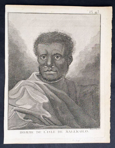
1778 Capt. Cook Antique Print Portrait A Man of Malakula Island Vanuatu in 1774
- Title : Homme de L Isle de Mallicolo
- Ref : 21347
- Size: 10in x 8in (255mm x 205mm)
- Date : 1778
- Condition: (A+) Fine Condition
Description:
This fine original copper-plate engraved antique print, portrait of a Man of the Island of Malakula (Mallicolo) in the Vanuatu group of Islands in the South Pacific, visited by Captain James Cook during his 2nd Voyage of Discovery in the South Seas in September 1774, was engraved by Robert Benard - after William Hodges - and was published in the 1778 French edition of Capt. James Cooks 2nd Voyage of Discovery to the South Seas A voyage towards the South Pole, and round the World. Performed in His Majestys ships the Resolution and Adventure, in the years 1772, 1773, 1774, and 1775..... Paris : Hotel de Thou ......1778
Cook Journal July, 1774
Arrival at The New Hebrides
On 17th Cook saw land bearing SW and later on decided this was the Australia Del Espiritu Santo of Quiros or what M. D. Bougainville calls the Great Cyclades. The island was Maewo. The next day its northern end was rounded in a gale and the ship sailed south between it and the island called by Bougainville the Isle of Lepers - Omba.
On 20th they crossed Patteson Passage with a view of geting to the South to explore the lands which lies there, and sailed down the west coast of Pentecost Isle (Raga). To the south they saw the island of Ambrin and behind it Paama and Epi. On 22nd, approaching Mallicollo (Malekula) we perceived a creek which had the appearence of a good harbour. Cook sent Lieutt [Richard] Pickersgill and the Master [Joseph Gilbert] in two Armd boats to Sound and look for Anchorage. The following day a good many [natives] came round us, some came in Canoes and others swam off\'... four I took into the Cabbin and made them various presents. Later, after some misunder-standing some natives began to Shoot Arrows... a Musquet discharged in the air and a four pounder over their heads sent them all off in the utmost confusion; those in the Cabbin leaped out of the Windows... About 9 o\'Clock we landed in the face of about 4 or 500 Men who were assembled on the Shore, armd with Bows and Arrows, clubs and Spears, but they made not the least opposission, on the contrary one Man gave his Arms to a nother and Met us in the water with a green branch in his hand, which [he] exchanged for the one I held in my hand. Just before departing Cook remarked they have not so much as a name for a Dog, consequently can have none, for which reason we left them a Dog and a Bitch.
General Definitions:
Paper thickness and quality: - Heavy and stable
Paper color : - off white
Age of map color: -
Colors used: -
General color appearance: -
Paper size: - 10in x 8in (255mm x 205mm)
Plate size: - 9 1/2in x 7 1/4in (240mm x 185mm)
Margins: - Min 1/2in (12mm)
Imperfections:
Margins: - Light soiling in margins
Plate area: - None
Verso: - None
Background:
Malakula Island also spelled Malekula, is the second-largest island in the nation of Vanuatu, in the Pacific Ocean region of Melanesia.
Discovered by the Spanish expedition of Pedro Fernández de Quirós in 1606 and visited by Captain Cook in 1774.
Vanuatu officially the Republic of Vanuatu is a Pacific island nation located in the South Pacific Ocean. The archipelago, which is of volcanic origin, is 1,750 kilometres east of northern Australia, 540 kilometres northeast of New Caledonia, east of New Guinea, southeast of the Solomon Islands, and west of Fiji.
Vanuatu was first inhabited by Melanesian people. The first Europeans to visit the islands were a Spanish expedition led by Portuguese navigator Fernandes de Queirós, who arrived on the largest island in 1606. Since the Portuguese and Spanish monarchies had been unified under the king of Spain in 1580 (following the vacancy of the Portuguese throne, which lasted for sixty years, until 1640, when the Portuguese monarchy was restored), Queirós claimed the archipelago for Spain, as part of the colonial Spanish East Indies, and named it La Austrialia del Espiritu Santo.
The Vanuatu group of islands first had contact with Europeans in 1606, when the Portuguese explorer Pedro Fernandes de Queiros, sailing for the Spanish Crown, arrived on the largest island and called the group of islands La Austrialia del Espiritu Santo or The Southern Land of the Holy Spirit, believing he had arrived in Terra Australis or Australia. The Spanish established a short-lived settlement at Big Bay on the north side of the island. The name Espiritu Santo remains to this day.
Europeans did not return until 1768, when Louis Antoine de Bougainville rediscovered the islands on 22 May, naming them the Great Cyclades. In 1774, Captain Cook named the islands the New Hebrides, a name that would last until independence in 1980.
William Hodges RA 1744 – 1797 was an English painter. He was a member of James Cooks second voyage to the Pacific Ocean, and is best known for the sketches and paintings of locations he visited on that voyage, including Table Bay, Tahiti, Easter Island, and the Antarctic.
Between 1772 and 1775 Hodges accompanied James Cook to the Pacific as the expeditions artist. Many of his sketches and wash paintings were adapted as engravings in the original published edition of Cooks journals from the voyage.
Most of the large-scale landscape oil paintings from his Pacific travels for which Hodges is best known were finished after his return to London; he received a salary from the Admiralty for the purposes of completing them. These paintings depicted a stronger light and shadow than had been usual in European landscape tradition. Contemporary art critics complained that his use of light and colour contrasts gave his paintings a rough and unfinished appearance.
Hodges also produced many valuable portrait sketches of Pacific islanders and scenes from the voyage involving members of the expedition..
Robert Bénard 1734 – 1777 was an 18th-century French engraver.
Specialized in the technique of engraving, Robert Ménard is mainly famous for having supplied a significant amount of plates (at least 1,800) to the Encyclopédie by Diderot & d\'Alembert from 1751.
Later, publisher Charles-Joseph Panckoucke reused many of his productions to illustrate the works of his catalog.
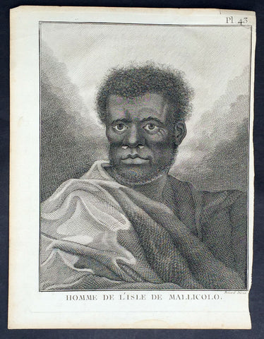
1778 Capt. Cook Antique Print Portrait A Man of Malakula Island Vanuatu in 1774
- Title : Homme de L Isle de Mallicolo
- Ref : 31773
- Size: 10in x 8in (255mm x 205mm)
- Date : 1778
- Condition: (A+) Fine Condition
Description:
This fine original copper-plate engraved antique print, portrait of a Man of the Island of Malakula (Mallicolo) in the Vanuatu group of Islands in the South Pacific, visited by Captain James Cook during his 2nd Voyage of Discovery in the South Seas in September 1774, was engraved by Robert Benard - after William Hodges - and was published in the 1778 French edition of Capt. James Cooks 2nd Voyage of Discovery to the South Seas A voyage towards the South Pole, and round the World. Performed in His Majestys ships the Resolution and Adventure, in the years 1772, 1773, 1774, and 1775..... Paris : Hotel de Thou ......1778
Cook Journal July, 1774
Arrival at The New Hebrides
On 17th Cook saw land bearing SW and later on decided this was the Australia Del Espiritu Santo of Quiros or what M. D. Bougainville calls the Great Cyclades. The island was Maewo. The next day its northern end was rounded in a gale and the ship sailed south between it and the island called by Bougainville the Isle of Lepers - Omba.
On 20th they crossed Patteson Passage with a view of geting to the South to explore the lands which lies there, and sailed down the west coast of Pentecost Isle (Raga). To the south they saw the island of Ambrin and behind it Paama and Epi. On 22nd, approaching Mallicollo (Malekula) we perceived a creek which had the appearence of a good harbour. Cook sent Lieutt [Richard] Pickersgill and the Master [Joseph Gilbert] in two Armd boats to Sound and look for Anchorage. The following day a good many [natives] came round us, some came in Canoes and others swam off\'... four I took into the Cabbin and made them various presents. Later, after some misunder-standing some natives began to Shoot Arrows... a Musquet discharged in the air and a four pounder over their heads sent them all off in the utmost confusion; those in the Cabbin leaped out of the Windows... About 9 o\'Clock we landed in the face of about 4 or 500 Men who were assembled on the Shore, armd with Bows and Arrows, clubs and Spears, but they made not the least opposission, on the contrary one Man gave his Arms to a nother and Met us in the water with a green branch in his hand, which [he] exchanged for the one I held in my hand. Just before departing Cook remarked they have not so much as a name for a Dog, consequently can have none, for which reason we left them a Dog and a Bitch.
General Definitions:
Paper thickness and quality: - Heavy and stable
Paper color : - off white
Age of map color: -
Colors used: -
General color appearance: -
Paper size: - 10in x 8in (255mm x 205mm)
Plate size: - 9 1/2in x 7 1/4in (240mm x 185mm)
Margins: - Min 1/2in (12mm)
Imperfections:
Margins: - Light soiling in margins
Plate area: - None
Verso: - None
Background:
Malakula Island also spelled Malekula, is the second-largest island in the nation of Vanuatu, in the Pacific Ocean region of Melanesia.
Discovered by the Spanish expedition of Pedro Fernández de Quirós in 1606 and visited by Captain Cook in 1774.
Vanuatu officially the Republic of Vanuatu is a Pacific island nation located in the South Pacific Ocean. The archipelago, which is of volcanic origin, is 1,750 kilometres east of northern Australia, 540 kilometres northeast of New Caledonia, east of New Guinea, southeast of the Solomon Islands, and west of Fiji.
Vanuatu was first inhabited by Melanesian people. The first Europeans to visit the islands were a Spanish expedition led by Portuguese navigator Fernandes de Queirós, who arrived on the largest island in 1606. Since the Portuguese and Spanish monarchies had been unified under the king of Spain in 1580 (following the vacancy of the Portuguese throne, which lasted for sixty years, until 1640, when the Portuguese monarchy was restored), Queirós claimed the archipelago for Spain, as part of the colonial Spanish East Indies, and named it La Austrialia del Espiritu Santo.
The Vanuatu group of islands first had contact with Europeans in 1606, when the Portuguese explorer Pedro Fernandes de Queiros, sailing for the Spanish Crown, arrived on the largest island and called the group of islands La Austrialia del Espiritu Santo or The Southern Land of the Holy Spirit, believing he had arrived in Terra Australis or Australia. The Spanish established a short-lived settlement at Big Bay on the north side of the island. The name Espiritu Santo remains to this day.
Europeans did not return until 1768, when Louis Antoine de Bougainville rediscovered the islands on 22 May, naming them the Great Cyclades. In 1774, Captain Cook named the islands the New Hebrides, a name that would last until independence in 1980.
William Hodges RA 1744 – 1797 was an English painter. He was a member of James Cooks second voyage to the Pacific Ocean, and is best known for the sketches and paintings of locations he visited on that voyage, including Table Bay, Tahiti, Easter Island, and the Antarctic.
Between 1772 and 1775 Hodges accompanied James Cook to the Pacific as the expeditions artist. Many of his sketches and wash paintings were adapted as engravings in the original published edition of Cooks journals from the voyage.
Most of the large-scale landscape oil paintings from his Pacific travels for which Hodges is best known were finished after his return to London; he received a salary from the Admiralty for the purposes of completing them. These paintings depicted a stronger light and shadow than had been usual in European landscape tradition. Contemporary art critics complained that his use of light and colour contrasts gave his paintings a rough and unfinished appearance.
Hodges also produced many valuable portrait sketches of Pacific islanders and scenes from the voyage involving members of the expedition..
Robert Bénard 1734 – 1777 was an 18th-century French engraver.
Specialized in the technique of engraving, Robert Ménard is mainly famous for having supplied a significant amount of plates (at least 1,800) to the Encyclopédie by Diderot & d\'Alembert from 1751.
Later, publisher Charles-Joseph Panckoucke reused many of his productions to illustrate the works of his catalog.
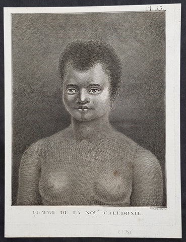
1778 Capt. Cook Antique Print Portrait of a Woman of New Caledonia Visit in 1774
- Title : Femme de la Noule. Caledonie
- Ref : 21327
- Size: 10in x 8in (255mm x 205mm)
- Date : 1778
- Condition: (A+) Fine Condition
Description:
This fine original copper-plate engraved antique print, portrait of a Woman of the Islands of New Caledonia in the South Pacific, visited by Captain James Cook during his 2nd Voyage of Discovery in the South Seas in September 1774, was engraved by Robert Benard - after William Hodges - and was published in the 1778 French edition of Capt. James Cooks 2nd Voyage of Discovery to the South Seas A voyage towards the South Pole, and round the World. Performed in His Majestys ships the Resolution and Adventure, in the years 1772, 1773, 1774, and 1775..... Paris : Hotel de Thou ......1778
Cook Diary, 4-13th Sep. 1774
4th Sun. Sights Cape Colnett (New Caledonia).
5th Mon. Enters reef (Amoss Passage) between Cook Reef and Balade Reef, anchors off Observatory Isle (Pudiu), visited by inhabitants.
6th Tue. Goes ashore with armed boats, rows along coast, returns to ship. Visited by natives, meets Chief, Teeabooma. Wales and Pickersgill land on Isle, Cook goes to help. Observatory set up for eclipse of Sun.
7th Wed. Eclipse, cloudy at first, observations made. Returns to ship, goes ashore again and returns. Simon Monk, ship’s butcher, dies after fall down fore-hatchway previous night.
8th Thu. Goes ashore. Excursion to west. The Forsters and Cook are ill with eating poisoned fish, liver and roe (Toadfish).
9th Fri. Exchanges presents with Teeabooma but still indisposed.
10th Sat. Forster ashore botanising.
12th Mon. Cutter is damaged when Gilbert and Pickersgill are returning from a visit to the north-west of island. Repairs made.
13th Tue. Takes possession of island in name of King George III, naming it New Caledonia. Sails back through reef and heads NW. along coast, outside Cook Reef, passes Great False Passage.
General Definitions:
Paper thickness and quality: - Heavy and stable
Paper color : - off white
Age of map color: -
Colors used: -
General color appearance: -
Paper size: - 10in x 8in (255mm x 205mm)
Plate size: - 9 1/2in x 7 1/4in (240mm x 185mm)
Margins: - Min 1/2in (12mm)
Imperfections:
Margins: - Light soiling in margins
Plate area: - None
Verso: - None
Background:
New Caledonia is a special collective of France in the southwest Pacific Ocean, 1,210 km east of Australia and 20,000 km from Metropolitan France. The archipelago, part of the Melanesia sub-region, includes the main island of Grande Terre, the Loyalty Islands, the Chesterfield Islands, the Belep archipelago, the Isle of Pines, and a few remote islets. The Chesterfield Islands are in the Coral Sea. Locals refer to Grande Terre as Le Caillou (the pebble)
British explorer Captain James Cook was the first European to sight New Caledonia, on 4 September 1774, during his second voyage. He named it New Caledonia, as the northeast of the island reminded him of Scotland. The west coast of Grande Terre was approached by Jean-François de Galaup, comte de Lapérouse in 1788, shortly before his disappearance, and the Loyalty Islands were first visited between 1793 and 1796 when Mare, Lifou, Tiga, and Ouvea were mapped by William Raven. The American whaler encountered the island named then Britania, and today known as Mar (Loyalty Is.) in November 1793. From 1796 until 1840, only a few sporadic contacts with the archipelago were recorded. About fifty American whalers (identified by Robert Langsom from their log books) have been recorded in the region (Grande Terre, Loyalty Is., Walpole and Hunter) between 1793 and 1887. Contacts became more frequent after 1840, because of the interest in sandalwood
William Hodges RA 1744 – 1797 was an English painter. He was a member of James Cooks second voyage to the Pacific Ocean, and is best known for the sketches and paintings of locations he visited on that voyage, including Table Bay, Tahiti, Easter Island, and the Antarctic.
Between 1772 and 1775 Hodges accompanied James Cook to the Pacific as the expeditions artist. Many of his sketches and wash paintings were adapted as engravings in the original published edition of Cooks journals from the voyage.
Most of the large-scale landscape oil paintings from his Pacific travels for which Hodges is best known were finished after his return to London; he received a salary from the Admiralty for the purposes of completing them. These paintings depicted a stronger light and shadow than had been usual in European landscape tradition. Contemporary art critics complained that his use of light and colour contrasts gave his paintings a rough and unfinished appearance.
Hodges also produced many valuable portrait sketches of Pacific islanders and scenes from the voyage involving members of the expedition..
Robert Bénard 1734 – 1777 was an 18th-century French engraver.
Specialized in the technique of engraving, Robert Ménard is mainly famous for having supplied a significant amount of plates (at least 1,800) to the Encyclopédie by Diderot & d\'Alembert from 1751.
Later, publisher Charles-Joseph Panckoucke reused many of his productions to illustrate the works of his catalog.
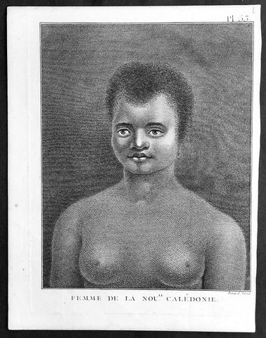
1778 Capt. Cook Antique Print Portrait of a Woman of New Caledonia Visit in 1774
- Title : Femme de la Noule. Caledonie
- Ref : 91210
- Size: 10in x 8in (255mm x 205mm)
- Date : 1778
- Condition: (A+) Fine Condition
Description:
This fine original copper-plate engraved antique print, portrait of a Woman of the Islands of New Caledonia in the South Pacific, visited by Captain James Cook during his 2nd Voyage of Discovery in the South Seas in September 1774, was engraved by Robert Benard - after William Hodges - and was published in the 1778 French edition of Capt. James Cooks 2nd Voyage of Discovery to the South Seas A voyage towards the South Pole, and round the World. Performed in His Majestys ships the Resolution and Adventure, in the years 1772, 1773, 1774, and 1775..... Paris : Hotel de Thou ......1778
Cook Diary, 4-13th Sep. 1774
4th Sun. Sights Cape Colnett (New Caledonia).
5th Mon. Enters reef (Amoss Passage) between Cook Reef and Balade Reef, anchors off Observatory Isle (Pudiu), visited by inhabitants.
6th Tue. Goes ashore with armed boats, rows along coast, returns to ship. Visited by natives, meets Chief, Teeabooma. Wales and Pickersgill land on Isle, Cook goes to help. Observatory set up for eclipse of Sun.
7th Wed. Eclipse, cloudy at first, observations made. Returns to ship, goes ashore again and returns. Simon Monk, ship’s butcher, dies after fall down fore-hatchway previous night.
8th Thu. Goes ashore. Excursion to west. The Forsters and Cook are ill with eating poisoned fish, liver and roe (Toadfish).
9th Fri. Exchanges presents with Teeabooma but still indisposed.
10th Sat. Forster ashore botanising.
12th Mon. Cutter is damaged when Gilbert and Pickersgill are returning from a visit to the north-west of island. Repairs made.
13th Tue. Takes possession of island in name of King George III, naming it New Caledonia. Sails back through reef and heads NW. along coast, outside Cook Reef, passes Great False Passage.
General Definitions:
Paper thickness and quality: - Heavy and stable
Paper color : - off white
Age of map color: -
Colors used: -
General color appearance: -
Paper size: - 10in x 8in (255mm x 205mm)
Plate size: - 9 1/2in x 7 1/4in (240mm x 185mm)
Margins: - Min 1/2in (12mm)
Imperfections:
Margins: - Light soiling in margins
Plate area: - None
Verso: - None
Background:
New Caledonia is a special collective of France in the southwest Pacific Ocean, 1,210 km east of Australia and 20,000 km from Metropolitan France. The archipelago, part of the Melanesia sub-region, includes the main island of Grande Terre, the Loyalty Islands, the Chesterfield Islands, the Belep archipelago, the Isle of Pines, and a few remote islets. The Chesterfield Islands are in the Coral Sea. Locals refer to Grande Terre as Le Caillou (the pebble)
British explorer Captain James Cook was the first European to sight New Caledonia, on 4 September 1774, during his second voyage. He named it New Caledonia, as the northeast of the island reminded him of Scotland. The west coast of Grande Terre was approached by Jean-François de Galaup, comte de Lapérouse in 1788, shortly before his disappearance, and the Loyalty Islands were first visited between 1793 and 1796 when Mare, Lifou, Tiga, and Ouvea were mapped by William Raven. The American whaler encountered the island named then Britania, and today known as Mar (Loyalty Is.) in November 1793. From 1796 until 1840, only a few sporadic contacts with the archipelago were recorded. About fifty American whalers (identified by Robert Langsom from their log books) have been recorded in the region (Grande Terre, Loyalty Is., Walpole and Hunter) between 1793 and 1887. Contacts became more frequent after 1840, because of the interest in sandalwood
William Hodges RA 1744 – 1797 was an English painter. He was a member of James Cooks second voyage to the Pacific Ocean, and is best known for the sketches and paintings of locations he visited on that voyage, including Table Bay, Tahiti, Easter Island, and the Antarctic.
Between 1772 and 1775 Hodges accompanied James Cook to the Pacific as the expeditions artist. Many of his sketches and wash paintings were adapted as engravings in the original published edition of Cooks journals from the voyage.
Most of the large-scale landscape oil paintings from his Pacific travels for which Hodges is best known were finished after his return to London; he received a salary from the Admiralty for the purposes of completing them. These paintings depicted a stronger light and shadow than had been usual in European landscape tradition. Contemporary art critics complained that his use of light and colour contrasts gave his paintings a rough and unfinished appearance.
Hodges also produced many valuable portrait sketches of Pacific islanders and scenes from the voyage involving members of the expedition..
Robert Bénard 1734 – 1777 was an 18th-century French engraver.
Specialized in the technique of engraving, Robert Ménard is mainly famous for having supplied a significant amount of plates (at least 1,800) to the Encyclopédie by Diderot & d\'Alembert from 1751.
Later, publisher Charles-Joseph Panckoucke reused many of his productions to illustrate the works of his catalog.
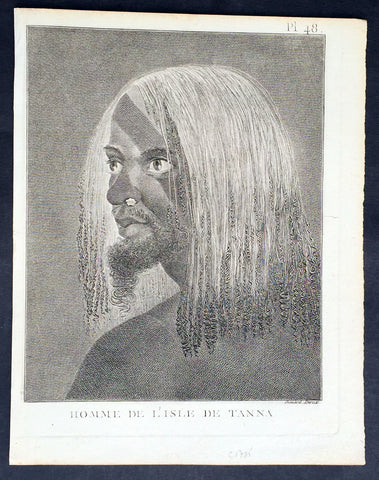
1778 Capt. Cook Antique Print of a Man of the Tanna Island, Vanuatu in 1774
- Title : Homme De L Isle de Tanna
- Ref : 21353
- Size: 10in x 8in (255mm x 205mm)
- Date : 1778
- Condition: (A+) Fine Condition
Description:
This fine original copper-plate engraved antique print, a portrait of a Man of the Island of Tanna in the Vanuatu group of Islands in the South Pacific, visited by Captain James Cook during his 2nd Voyage of Discovery in the South Seas in 1774, was engraved by Robert Benard - after William Hodges - and was published in the 1778 French edition of Capt. James Cooks 2nd Voyage of Discovery to the South Seas A voyage towards the South Pole, and round the World. Performed in His Majestys ships the Resolution and Adventure, in the years 1772, 1773, 1774, and 1775..... Paris : Hotel de Thou ......1778
Cook Diary, 6-20th August 1774
........the Women have all the same ornaments as Men, Nose-Stones, Earrings, Shells on the Breast & Bracelets...their heads covered with a kind of cap made of a Plantain leaf or a Mat-Basket. Few are covered, & even very young Girls have these Caps.......Cooks Journal II
General Definitions:
Paper thickness and quality: - Heavy and stable
Paper color : - off white
Age of map color: -
Colors used: -
General color appearance: -
Paper size: - 10in x 8in (255mm x 205mm)
Plate size: - 9 1/2in x 7 1/4in (240mm x 185mm)
Margins: - Min 1/2in (12mm)
Imperfections:
Margins: - Light soiling in margins
Plate area: - None
Verso: - None
Background:
Tanna (sometimes spelled Tana) is an island in Tafea Province of Vanuatu.
Tanna was first settled about 400 BC by Melanesians from the surrounding islands. The glowing light of Mount Yasur attracted James Cook, the first European to visit the island, in August 1774, where he landed in an inlet on the southeastern tip of the island that he named Port Resolution after his ship HMS Resolution. He gave the island the name of Tanna, probably from the local name for earth, tana in the Kwamera language.
Vanuatu is a Pacific island nation located in the South Pacific Ocean. The archipelago, which is of volcanic origin, is 1,750 kilometres east of northern Australia, 540 kilometres northeast of New Caledonia, east of New Guinea, southeast of the Solomon Islands, and west of Fiji.
The Vanuatu group of islands first had contact with Europeans in 1606, when the Portuguese explorer Pedro Fernandes de Queirós, sailing for the Spanish Crown, arrived on the largest island and called the group of islands La Austrialia del Espiritu Santo or The Southern Land of the Holy Spirit, believing he had arrived in Terra Australis or Australia. The Spanish established a short-lived settlement at Big Bay on the north side of the island. The name Espiritu Santo remains to this day.
Europeans did not return until 1768, when Louis Antoine de Bougainville rediscovered the islands on 22 May, naming them the Great Cyclades. In 1774, Captain Cook named the islands the New Hebrides, a name that would last until independence in 1980.
William Hodges RA 1744 – 1797 was an English painter. He was a member of James Cooks second voyage to the Pacific Ocean, and is best known for the sketches and paintings of locations he visited on that voyage, including Table Bay, Tahiti, Easter Island, and the Antarctic.
Between 1772 and 1775 Hodges accompanied James Cook to the Pacific as the expeditions artist. Many of his sketches and wash paintings were adapted as engravings in the original published edition of Cooks journals from the voyage.
Most of the large-scale landscape oil paintings from his Pacific travels for which Hodges is best known were finished after his return to London; he received a salary from the Admiralty for the purposes of completing them. These paintings depicted a stronger light and shadow than had been usual in European landscape tradition. Contemporary art critics complained that his use of light and colour contrasts gave his paintings a rough and unfinished appearance.
Hodges also produced many valuable portrait sketches of Pacific islanders and scenes from the voyage involving members of the expedition..
Robert Bénard 1734 – 1777 was an 18th-century French engraver.
Specialized in the technique of engraving, Robert Ménard is mainly famous for having supplied a significant amount of plates (at least 1,800) to the Encyclopédie by Diderot & d\'Alembert from 1751.
Later, publisher Charles-Joseph Panckoucke reused many of his productions to illustrate the works of his catalog.
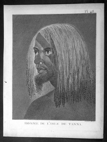
1778 Capt. Cook Antique Print of a Man of the Tanna Island, Vanuatu in 1774
- Title : Homme De L Isle de Tanna
- Ref : 16344-1
- Size: 10in x 8in (255mm x 205mm)
- Date : 1778
- Condition: (A+) Fine Condition
Description:
This fine original copper-plate engraved antique print, a portrait of a Man of the Island of Tanna in the Vanuatu group of Islands in the South Pacific, visited by Captain James Cook during his 2nd Voyage of Discovery in the South Seas in 1774, was engraved by Robert Benard - after William Hodges - and was published in the 1778 French edition of Capt. James Cooks 2nd Voyage of Discovery to the South Seas A voyage towards the South Pole, and round the World. Performed in His Majestys ships the Resolution and Adventure, in the years 1772, 1773, 1774, and 1775..... Paris : Hotel de Thou ......1778
Cook Diary, 6-20th August 1774
........the Women have all the same ornaments as Men, Nose-Stones, Earrings, Shells on the Breast & Bracelets...their heads covered with a kind of cap made of a Plantain leaf or a Mat-Basket. Few are covered, & even very young Girls have these Caps.......Cooks Journal II
General Definitions:
Paper thickness and quality: - Heavy and stable
Paper color : - off white
Age of map color: -
Colors used: -
General color appearance: -
Paper size: - 10in x 8in (255mm x 205mm)
Plate size: - 9 1/2in x 7 1/4in (240mm x 185mm)
Margins: - Min 1/2in (12mm)
Imperfections:
Margins: - Light soiling in margins
Plate area: - None
Verso: - None
Background:
Tanna (sometimes spelled Tana) is an island in Tafea Province of Vanuatu.
Tanna was first settled about 400 BC by Melanesians from the surrounding islands. The glowing light of Mount Yasur attracted James Cook, the first European to visit the island, in August 1774, where he landed in an inlet on the southeastern tip of the island that he named Port Resolution after his ship HMS Resolution. He gave the island the name of Tanna, probably from the local name for earth, tana in the Kwamera language.
Vanuatu is a Pacific island nation located in the South Pacific Ocean. The archipelago, which is of volcanic origin, is 1,750 kilometres east of northern Australia, 540 kilometres northeast of New Caledonia, east of New Guinea, southeast of the Solomon Islands, and west of Fiji.
The Vanuatu group of islands first had contact with Europeans in 1606, when the Portuguese explorer Pedro Fernandes de Queirós, sailing for the Spanish Crown, arrived on the largest island and called the group of islands La Austrialia del Espiritu Santo or The Southern Land of the Holy Spirit, believing he had arrived in Terra Australis or Australia. The Spanish established a short-lived settlement at Big Bay on the north side of the island. The name Espiritu Santo remains to this day.
Europeans did not return until 1768, when Louis Antoine de Bougainville rediscovered the islands on 22 May, naming them the Great Cyclades. In 1774, Captain Cook named the islands the New Hebrides, a name that would last until independence in 1980.
William Hodges RA 1744 – 1797 was an English painter. He was a member of James Cooks second voyage to the Pacific Ocean, and is best known for the sketches and paintings of locations he visited on that voyage, including Table Bay, Tahiti, Easter Island, and the Antarctic.
Between 1772 and 1775 Hodges accompanied James Cook to the Pacific as the expeditions artist. Many of his sketches and wash paintings were adapted as engravings in the original published edition of Cooks journals from the voyage.
Most of the large-scale landscape oil paintings from his Pacific travels for which Hodges is best known were finished after his return to London; he received a salary from the Admiralty for the purposes of completing them. These paintings depicted a stronger light and shadow than had been usual in European landscape tradition. Contemporary art critics complained that his use of light and colour contrasts gave his paintings a rough and unfinished appearance.
Hodges also produced many valuable portrait sketches of Pacific islanders and scenes from the voyage involving members of the expedition..
Robert Bénard 1734 – 1777 was an 18th-century French engraver.
Specialized in the technique of engraving, Robert Ménard is mainly famous for having supplied a significant amount of plates (at least 1,800) to the Encyclopédie by Diderot & d\'Alembert from 1751.
Later, publisher Charles-Joseph Panckoucke reused many of his productions to illustrate the works of his catalog.
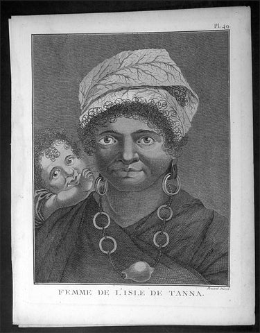
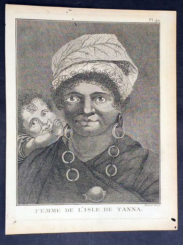
1778 Capt. Cook Antique Print Portrait of a Woman of Tanna Isle, Vanuatu in 1774
- Title : Femme De L Isle de Tanna
- Ref : 16354
- Size: 10in x 8in (255mm x 205mm)
- Date : 1778
- Condition: (A+) Fine Condition
Description:
This fine original copper-plate engraved antique print, a portrait of a Woman & Child of the Island of Tanna in the Vanuatu group of Islands in the South Pacific, visited by Captain James Cook during his 2nd Voyage of Discovery in the South Seas in 1774, was engraved by Robert Benard - after William Hodges - and was published in the 1778 French edition of Capt. James Cooks 2nd Voyage of Discovery to the South Seas A voyage towards the South Pole, and round the World. Performed in His Majestys ships the Resolution and Adventure, in the years 1772, 1773, 1774, and 1775..... Paris : Hotel de Thou ......1778
Cook Diary, 6-20th August 1774
........the Women have all the same ornaments as Men, Nose-Stones, Earrings, Shells on the Breast & Bracelets...their heads covered with a kind of cap made of a Plantain leaf or a Mat-Basket. Few are covered, & even very young Girls have these Caps.......Cooks Journal II
General Definitions:
Paper thickness and quality: - Heavy and stable
Paper color : - off white
Age of map color: -
Colors used: -
General color appearance: -
Paper size: - 10in x 8in (255mm x 205mm)
Plate size: - 9 1/2in x 7 1/4in (240mm x 185mm)
Margins: - Min 1/2in (12mm)
Imperfections:
Margins: - Light soiling in margins
Plate area: - None
Verso: - None
Background:
Tanna (sometimes spelled Tana) is an island in Tafea Province of Vanuatu.
Tanna was first settled about 400 BC by Melanesians from the surrounding islands. The glowing light of Mount Yasur attracted James Cook, the first European to visit the island, in August 1774, where he landed in an inlet on the southeastern tip of the island that he named Port Resolution after his ship HMS Resolution. He gave the island the name of Tanna, probably from the local name for earth, tana in the Kwamera language.
Vanuatu is a Pacific island nation located in the South Pacific Ocean. The archipelago, which is of volcanic origin, is 1,750 kilometres east of northern Australia, 540 kilometres northeast of New Caledonia, east of New Guinea, southeast of the Solomon Islands, and west of Fiji.
The Vanuatu group of islands first had contact with Europeans in 1606, when the Portuguese explorer Pedro Fernandes de Queirós, sailing for the Spanish Crown, arrived on the largest island and called the group of islands La Austrialia del Espiritu Santo or The Southern Land of the Holy Spirit, believing he had arrived in Terra Australis or Australia. The Spanish established a short-lived settlement at Big Bay on the north side of the island. The name Espiritu Santo remains to this day.
Europeans did not return until 1768, when Louis Antoine de Bougainville rediscovered the islands on 22 May, naming them the Great Cyclades. In 1774, Captain Cook named the islands the New Hebrides, a name that would last until independence in 1980.
William Hodges RA 1744 – 1797 was an English painter. He was a member of James Cooks second voyage to the Pacific Ocean, and is best known for the sketches and paintings of locations he visited on that voyage, including Table Bay, Tahiti, Easter Island, and the Antarctic.
Between 1772 and 1775 Hodges accompanied James Cook to the Pacific as the expeditions artist. Many of his sketches and wash paintings were adapted as engravings in the original published edition of Cooks journals from the voyage.
Most of the large-scale landscape oil paintings from his Pacific travels for which Hodges is best known were finished after his return to London; he received a salary from the Admiralty for the purposes of completing them. These paintings depicted a stronger light and shadow than had been usual in European landscape tradition. Contemporary art critics complained that his use of light and colour contrasts gave his paintings a rough and unfinished appearance.
Hodges also produced many valuable portrait sketches of Pacific islanders and scenes from the voyage involving members of the expedition..
Robert Bénard 1734 – 1777 was an 18th-century French engraver.
Specialized in the technique of engraving, Robert Ménard is mainly famous for having supplied a significant amount of plates (at least 1,800) to the Encyclopédie by Diderot & d\'Alembert from 1751.
Later, publisher Charles-Joseph Panckoucke reused many of his productions to illustrate the works of his catalog.
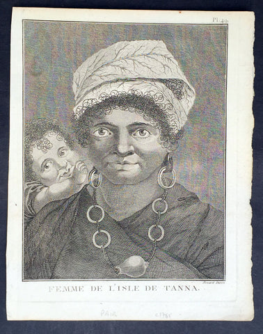
1778 Capt. Cook Antique Print Portrait of a Woman of Tanna Isle, Vanuatu in 1774
- Title : Femme De L Isle de Tanna
- Ref : 21354
- Size: 10in x 8in (255mm x 205mm)
- Date : 1778
- Condition: (A+) Fine Condition
Description:
This fine original copper-plate engraved antique print, a portrait of a Woman & Child of the Island of Tanna in the Vanuatu group of Islands in the South Pacific, visited by Captain James Cook during his 2nd Voyage of Discovery in the South Seas in 1774, was engraved by Robert Benard - after William Hodges - and was published in the 1778 French edition of Capt. James Cooks 2nd Voyage of Discovery to the South Seas A voyage towards the South Pole, and round the World. Performed in His Majestys ships the Resolution and Adventure, in the years 1772, 1773, 1774, and 1775..... Paris : Hotel de Thou ......1778
Cook Diary, 6-20th August 1774
........the Women have all the same ornaments as Men, Nose-Stones, Earrings, Shells on the Breast & Bracelets...their heads covered with a kind of cap made of a Plantain leaf or a Mat-Basket. Few are covered, & even very young Girls have these Caps.......Cooks Journal II
General Definitions:
Paper thickness and quality: - Heavy and stable
Paper color : - off white
Age of map color: -
Colors used: -
General color appearance: -
Paper size: - 10in x 8in (255mm x 205mm)
Plate size: - 9 1/2in x 7 1/4in (240mm x 185mm)
Margins: - Min 1/2in (12mm)
Imperfections:
Margins: - Light soiling in margins
Plate area: - None
Verso: - None
Background:
Tanna (sometimes spelled Tana) is an island in Tafea Province of Vanuatu.
Tanna was first settled about 400 BC by Melanesians from the surrounding islands. The glowing light of Mount Yasur attracted James Cook, the first European to visit the island, in August 1774, where he landed in an inlet on the southeastern tip of the island that he named Port Resolution after his ship HMS Resolution. He gave the island the name of Tanna, probably from the local name for earth, tana in the Kwamera language.
Vanuatu is a Pacific island nation located in the South Pacific Ocean. The archipelago, which is of volcanic origin, is 1,750 kilometres east of northern Australia, 540 kilometres northeast of New Caledonia, east of New Guinea, southeast of the Solomon Islands, and west of Fiji.
The Vanuatu group of islands first had contact with Europeans in 1606, when the Portuguese explorer Pedro Fernandes de Queirós, sailing for the Spanish Crown, arrived on the largest island and called the group of islands La Austrialia del Espiritu Santo or The Southern Land of the Holy Spirit, believing he had arrived in Terra Australis or Australia. The Spanish established a short-lived settlement at Big Bay on the north side of the island. The name Espiritu Santo remains to this day.
Europeans did not return until 1768, when Louis Antoine de Bougainville rediscovered the islands on 22 May, naming them the Great Cyclades. In 1774, Captain Cook named the islands the New Hebrides, a name that would last until independence in 1980.
William Hodges RA 1744 – 1797 was an English painter. He was a member of James Cooks second voyage to the Pacific Ocean, and is best known for the sketches and paintings of locations he visited on that voyage, including Table Bay, Tahiti, Easter Island, and the Antarctic.
Between 1772 and 1775 Hodges accompanied James Cook to the Pacific as the expeditions artist. Many of his sketches and wash paintings were adapted as engravings in the original published edition of Cooks journals from the voyage.
Most of the large-scale landscape oil paintings from his Pacific travels for which Hodges is best known were finished after his return to London; he received a salary from the Admiralty for the purposes of completing them. These paintings depicted a stronger light and shadow than had been usual in European landscape tradition. Contemporary art critics complained that his use of light and colour contrasts gave his paintings a rough and unfinished appearance.
Hodges also produced many valuable portrait sketches of Pacific islanders and scenes from the voyage involving members of the expedition..
Robert Bénard 1734 – 1777 was an 18th-century French engraver.
Specialized in the technique of engraving, Robert Ménard is mainly famous for having supplied a significant amount of plates (at least 1,800) to the Encyclopédie by Diderot & d\'Alembert from 1751.
Later, publisher Charles-Joseph Panckoucke reused many of his productions to illustrate the works of his catalog.
1778 Capt. Cook Antique Print Portrait of a Woman of Tanna Isle, Vanuatu in 1774
- Title : Femme De L Isle de Tanna
- Ref : 31782
- Size: 10in x 8in (255mm x 205mm)
- Date : 1778
- Condition: (A+) Fine Condition
Description:
This fine original copper-plate engraved antique print, a portrait of a Woman & Child of the Island of Tanna in the Vanuatu group of Islands in the South Pacific, visited by Captain James Cook during his 2nd Voyage of Discovery in the South Seas in 1774, was engraved by Robert Benard - after William Hodges - and was published in the 1778 French edition of Capt. James Cooks 2nd Voyage of Discovery to the South Seas A voyage towards the South Pole, and round the World. Performed in His Majestys ships the Resolution and Adventure, in the years 1772, 1773, 1774, and 1775..... Paris : Hotel de Thou ......1778
Cook Diary, 6-20th August 1774
........the Women have all the same ornaments as Men, Nose-Stones, Earrings, Shells on the Breast & Bracelets...their heads covered with a kind of cap made of a Plantain leaf or a Mat-Basket. Few are covered, & even very young Girls have these Caps.......Cooks Journal II
General Definitions:
Paper thickness and quality: - Heavy and stable
Paper color : - off white
Age of map color: -
Colors used: -
General color appearance: -
Paper size: - 10in x 8in (255mm x 205mm)
Plate size: - 9 1/2in x 7 1/4in (240mm x 185mm)
Margins: - Min 1/2in (12mm)
Imperfections:
Margins: - Light soiling in margins
Plate area: - None
Verso: - None
Background:
Tanna (sometimes spelled Tana) is an island in Tafea Province of Vanuatu.
Tanna was first settled about 400 BC by Melanesians from the surrounding islands. The glowing light of Mount Yasur attracted James Cook, the first European to visit the island, in August 1774, where he landed in an inlet on the southeastern tip of the island that he named Port Resolution after his ship HMS Resolution. He gave the island the name of Tanna, probably from the local name for earth, tana in the Kwamera language.
Vanuatu is a Pacific island nation located in the South Pacific Ocean. The archipelago, which is of volcanic origin, is 1,750 kilometres east of northern Australia, 540 kilometres northeast of New Caledonia, east of New Guinea, southeast of the Solomon Islands, and west of Fiji.
The Vanuatu group of islands first had contact with Europeans in 1606, when the Portuguese explorer Pedro Fernandes de Queirós, sailing for the Spanish Crown, arrived on the largest island and called the group of islands La Austrialia del Espiritu Santo or The Southern Land of the Holy Spirit, believing he had arrived in Terra Australis or Australia. The Spanish established a short-lived settlement at Big Bay on the north side of the island. The name Espiritu Santo remains to this day.
Europeans did not return until 1768, when Louis Antoine de Bougainville rediscovered the islands on 22 May, naming them the Great Cyclades. In 1774, Captain Cook named the islands the New Hebrides, a name that would last until independence in 1980.
William Hodges RA 1744 – 1797 was an English painter. He was a member of James Cooks second voyage to the Pacific Ocean, and is best known for the sketches and paintings of locations he visited on that voyage, including Table Bay, Tahiti, Easter Island, and the Antarctic.
Between 1772 and 1775 Hodges accompanied James Cook to the Pacific as the expeditions artist. Many of his sketches and wash paintings were adapted as engravings in the original published edition of Cooks journals from the voyage.
Most of the large-scale landscape oil paintings from his Pacific travels for which Hodges is best known were finished after his return to London; he received a salary from the Admiralty for the purposes of completing them. These paintings depicted a stronger light and shadow than had been usual in European landscape tradition. Contemporary art critics complained that his use of light and colour contrasts gave his paintings a rough and unfinished appearance.
Hodges also produced many valuable portrait sketches of Pacific islanders and scenes from the voyage involving members of the expedition..
Robert Bénard 1734 – 1777 was an 18th-century French engraver.
Specialized in the technique of engraving, Robert Ménard is mainly famous for having supplied a significant amount of plates (at least 1,800) to the Encyclopédie by Diderot & d\'Alembert from 1751.
Later, publisher Charles-Joseph Panckoucke reused many of his productions to illustrate the works of his catalog.
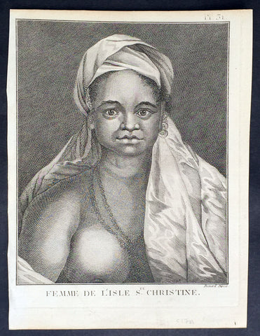
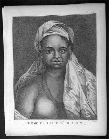
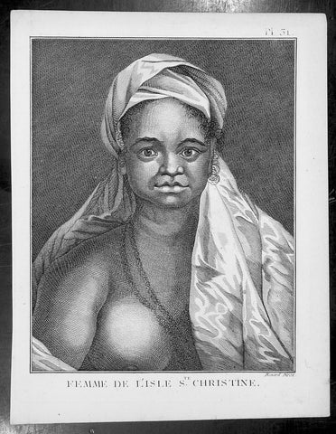
1778 Capt Cook Antique Print Portrait Princess of Tahuata, Marquesas Isles, 1774
- Title : Femme De L Isle de Ste. Christine
- Ref : 21399
- Size: 10in x 8in (255mm x 205mm)
- Date : 1778
- Condition: (A+) Fine Condition
Description:
This fine original copper-plate engraved antique print, a portrait of a Princess of Tahuata Island, Santa Cristina, in the Marquesas Islands, South Pacific, visited by Captain James Cook during his 2nd Voyage of Discovery in the South Seas in 1774, was engraved by Robert Benard - after William Hodges - and was published in the 1778 French edition of Capt. James Cooks 2nd Voyage of Discovery to the South Seas A voyage towards the South Pole, and round the World. Performed in His Majestys ships the Resolution and Adventure, in the years 1772, 1773, 1774, and 1775..... Paris : Hotel de Thou ......1778
Cook Diary (1774)
Apr. 7 Thu. Sights Hood’s Island (Fatu Huku), St. Pedro (Motare). La Dominica (Hiva Oa), St. Christina (Tahuata).
Apr 8 Fri. Sails along southern coast of Hiva Oa looking for anchorage. Anchors in Resolution (formerly Madre de Dios) Bay (Vaitahu Bay). Canoes arrive, gifts are exchanged. Natives killed after an iron stanchion is stolen.
Apr 9 Sat. Goes ashore, gifts exchanged, food obtained.
Apr 10 Sun. Goes ashore to south end of Bay and visits house of dead man. Gifts exchanged.
Apr 11 Mon. Goes ashore to south, again. Finds trade becoming expensive because of lavish gifts by his “gentlemen”.
Apr 12 Tue. Sails towards St. Dominica. No anchorage visible. Heads SW away from islands.
Apr 13 Wed. Sights last of the five main islands, Magdalena (Fatu Hiva).
General Definitions:
Paper thickness and quality: - Heavy and stable
Paper color : - off white
Age of map color: -
Colors used: -
General color appearance: -
Paper size: - 10in x 8in (255mm x 205mm)
Plate size: - 9 1/2in x 7 1/4in (240mm x 185mm)
Margins: - Min 1/2in (12mm)
Imperfections:
Margins: - Light soiling in margins
Plate area: - None
Verso: - None
Background:
Tahuata is the smallest of the inhabited Marquesas Islands, in French Polynesia, an overseas territory of France in the Pacific Ocean.
The first recorded sighting by Europeans was by the Spanish expedition of Álvaro de Mandaña on 22 July 1595. They charted the island as Santa Cristina. They landed at Vaitahu that they named Madre de Dios (Gods Mother in Spanish). According to the Spanish accounts Tahuata had fowls, fish, sugar cane, plantains, nuts and fruits. The existent town was built on two sides of a rectangular space, the houses being of timber and intertwined canes. A building which the Spaniards supposed to be a religious one stood outside the town, in a space enclosed by palisades, and containing some ill-carved images before which were offerings and provisions. The people had large and well constructed sailing canoes. Their tools were made of shells and fish bones. They used slings, stones, and lances as weapons.
Tahuata was visited by Captain James Cook in 1774 and Admiral Dupetit-Thouars in 1842, who signed the treaty annexing the Marquesas Islands to France.
The Marquesas Islands are a group of volcanic islands in French Polynesia, an overseas collective of France in the southern Pacific Ocean.
The first Europeans to reach the Marquesas may have been the crew of San Lesmes, a Spanish vessel which disappeared in a storm in June 1526; it was part of an expedition headed by García Jofre de Loaísa. The Spanish explorer Álvaro de Mendaña reached them seventy years later on 21 July 1595. He named them after his patron, García Hurtado de Mendoza, 5th Marquis of Cañete (Spanish: Marqués de Cañete), who served as Viceroy of Peru from 1590 to 1596. |Mendaña visited first Fatu Hiva and then Tahuata before continuing on to the Solomon Islands. His expedition charted the four southernmost Marquesas as Magdalena (Fatu Hiva), Dominica (Hiva ʻOa), San Pedro (Moho Tani), and Santa Cristina (Tahuata).
In the late 16th century European explorers estimated the population at more than 100,000. Europeans and Americans were impressed with how easy life appeared to be in the islands, which had a rich habitat and environment. In 1791 the American maritime fur trader Joseph Ingraham first visited the northern Marquesas while commanding the brig Hope. He named them the Washington Islands. In 1813 Commodore David Porter claimed Nuku Hiva for the United States, but the United States Congress never ratified that claim.
In 1842 France conducted a successful military operation on behalf of the native chief Iotete, who claimed he was king of the whole island of Tahuata. The government laid claim to the whole group and established a settlement on Nuku Hiva. That settlement was abandoned in 1857, but France re-established control over the group in 1870. It later incorporated the Marquesas into French Polynesia.
William Hodges RA 1744 – 1797 was an English painter. He was a member of James Cooks second voyage to the Pacific Ocean, and is best known for the sketches and paintings of locations he visited on that voyage, including Table Bay, Tahiti, Easter Island, and the Antarctic.
Between 1772 and 1775 Hodges accompanied James Cook to the Pacific as the expeditions artist. Many of his sketches and wash paintings were adapted as engravings in the original published edition of Cooks journals from the voyage.
Most of the large-scale landscape oil paintings from his Pacific travels for which Hodges is best known were finished after his return to London; he received a salary from the Admiralty for the purposes of completing them. These paintings depicted a stronger light and shadow than had been usual in European landscape tradition. Contemporary art critics complained that his use of light and colour contrasts gave his paintings a rough and unfinished appearance.
Hodges also produced many valuable portrait sketches of Pacific islanders and scenes from the voyage involving members of the expedition..
Robert Bénard 1734 – 1777 was an 18th-century French engraver.
Specialized in the technique of engraving, Robert Ménard is mainly famous for having supplied a significant amount of plates (at least 1,800) to the Encyclopédie by Diderot & d\'Alembert from 1751.
Later, publisher Charles-Joseph Panckoucke reused many of his productions to illustrate the works of his catalog.
1778 Capt Cook Antique Print Portrait Princess of Tahuata, Marquesas Isles, 1774
- Title : Femme De L Isle de Ste. Christine
- Ref : 16349
- Size: 10in x 8in (255mm x 205mm)
- Date : 1778
- Condition: (A+) Fine Condition
Description:
This fine original copper-plate engraved antique print, a portrait of a Princess of Tahuata Island, Santa Cristina, in the Marquesas Islands, South Pacific, visited by Captain James Cook during his 2nd Voyage of Discovery in the South Seas in 1774, was engraved by Robert Benard - after William Hodges - and was published in the 1778 French edition of Capt. James Cooks 2nd Voyage of Discovery to the South Seas A voyage towards the South Pole, and round the World. Performed in His Majestys ships the Resolution and Adventure, in the years 1772, 1773, 1774, and 1775..... Paris : Hotel de Thou ......1778
Cook Diary (1774)
Apr. 7 Thu. Sights Hood’s Island (Fatu Huku), St. Pedro (Motare). La Dominica (Hiva Oa), St. Christina (Tahuata).
Apr 8 Fri. Sails along southern coast of Hiva Oa looking for anchorage. Anchors in Resolution (formerly Madre de Dios) Bay (Vaitahu Bay). Canoes arrive, gifts are exchanged. Natives killed after an iron stanchion is stolen.
Apr 9 Sat. Goes ashore, gifts exchanged, food obtained.
Apr 10 Sun. Goes ashore to south end of Bay and visits house of dead man. Gifts exchanged.
Apr 11 Mon. Goes ashore to south, again. Finds trade becoming expensive because of lavish gifts by his “gentlemen”.
Apr 12 Tue. Sails towards St. Dominica. No anchorage visible. Heads SW away from islands.
Apr 13 Wed. Sights last of the five main islands, Magdalena (Fatu Hiva).
General Definitions:
Paper thickness and quality: - Heavy and stable
Paper color : - off white
Age of map color: -
Colors used: -
General color appearance: -
Paper size: - 10in x 8in (255mm x 205mm)
Plate size: - 9 1/2in x 7 1/4in (240mm x 185mm)
Margins: - Min 1/2in (12mm)
Imperfections:
Margins: - Light soiling in margins
Plate area: - None
Verso: - None
Background:
Tahuata is the smallest of the inhabited Marquesas Islands, in French Polynesia, an overseas territory of France in the Pacific Ocean.
The first recorded sighting by Europeans was by the Spanish expedition of Álvaro de Mandaña on 22 July 1595. They charted the island as Santa Cristina. They landed at Vaitahu that they named Madre de Dios (Gods Mother in Spanish). According to the Spanish accounts Tahuata had fowls, fish, sugar cane, plantains, nuts and fruits. The existent town was built on two sides of a rectangular space, the houses being of timber and intertwined canes. A building which the Spaniards supposed to be a religious one stood outside the town, in a space enclosed by palisades, and containing some ill-carved images before which were offerings and provisions. The people had large and well constructed sailing canoes. Their tools were made of shells and fish bones. They used slings, stones, and lances as weapons.
Tahuata was visited by Captain James Cook in 1774 and Admiral Dupetit-Thouars in 1842, who signed the treaty annexing the Marquesas Islands to France.
The Marquesas Islands are a group of volcanic islands in French Polynesia, an overseas collective of France in the southern Pacific Ocean.
The first Europeans to reach the Marquesas may have been the crew of San Lesmes, a Spanish vessel which disappeared in a storm in June 1526; it was part of an expedition headed by García Jofre de Loaísa. The Spanish explorer Álvaro de Mendaña reached them seventy years later on 21 July 1595. He named them after his patron, García Hurtado de Mendoza, 5th Marquis of Cañete (Spanish: Marqués de Cañete), who served as Viceroy of Peru from 1590 to 1596. |Mendaña visited first Fatu Hiva and then Tahuata before continuing on to the Solomon Islands. His expedition charted the four southernmost Marquesas as Magdalena (Fatu Hiva), Dominica (Hiva ʻOa), San Pedro (Moho Tani), and Santa Cristina (Tahuata).
In the late 16th century European explorers estimated the population at more than 100,000. Europeans and Americans were impressed with how easy life appeared to be in the islands, which had a rich habitat and environment. In 1791 the American maritime fur trader Joseph Ingraham first visited the northern Marquesas while commanding the brig Hope. He named them the Washington Islands. In 1813 Commodore David Porter claimed Nuku Hiva for the United States, but the United States Congress never ratified that claim.
In 1842 France conducted a successful military operation on behalf of the native chief Iotete, who claimed he was king of the whole island of Tahuata. The government laid claim to the whole group and established a settlement on Nuku Hiva. That settlement was abandoned in 1857, but France re-established control over the group in 1870. It later incorporated the Marquesas into French Polynesia.
William Hodges RA 1744 – 1797 was an English painter. He was a member of James Cooks second voyage to the Pacific Ocean, and is best known for the sketches and paintings of locations he visited on that voyage, including Table Bay, Tahiti, Easter Island, and the Antarctic.
Between 1772 and 1775 Hodges accompanied James Cook to the Pacific as the expeditions artist. Many of his sketches and wash paintings were adapted as engravings in the original published edition of Cooks journals from the voyage.
Most of the large-scale landscape oil paintings from his Pacific travels for which Hodges is best known were finished after his return to London; he received a salary from the Admiralty for the purposes of completing them. These paintings depicted a stronger light and shadow than had been usual in European landscape tradition. Contemporary art critics complained that his use of light and colour contrasts gave his paintings a rough and unfinished appearance.
Hodges also produced many valuable portrait sketches of Pacific islanders and scenes from the voyage involving members of the expedition..
Robert Bénard 1734 – 1777 was an 18th-century French engraver.
Specialized in the technique of engraving, Robert Ménard is mainly famous for having supplied a significant amount of plates (at least 1,800) to the Encyclopédie by Diderot & d\'Alembert from 1751.
Later, publisher Charles-Joseph Panckoucke reused many of his productions to illustrate the works of his catalog.
1778 Capt Cook Antique Print Portrait Princess of Tahuata, Marquesas Isles, 1774
- Title : Femme De L Isle de Ste. Christine
- Ref : 31806
- Size: 10in x 8in (255mm x 205mm)
- Date : 1778
- Condition: (A+) Fine Condition
Description:
This fine original copper-plate engraved antique print, a portrait of a Princess of Tahuata Island, Santa Cristina, in the Marquesas Islands, South Pacific, visited by Captain James Cook during his 2nd Voyage of Discovery in the South Seas in 1774, was engraved by Robert Benard - after William Hodges - and was published in the 1778 French edition of Capt. James Cooks 2nd Voyage of Discovery to the South Seas A voyage towards the South Pole, and round the World. Performed in His Majestys ships the Resolution and Adventure, in the years 1772, 1773, 1774, and 1775..... Paris : Hotel de Thou ......1778
Cook Diary (1774)
Apr. 7 Thu. Sights Hood’s Island (Fatu Huku), St. Pedro (Motare). La Dominica (Hiva Oa), St. Christina (Tahuata).
Apr 8 Fri. Sails along southern coast of Hiva Oa looking for anchorage. Anchors in Resolution (formerly Madre de Dios) Bay (Vaitahu Bay). Canoes arrive, gifts are exchanged. Natives killed after an iron stanchion is stolen.
Apr 9 Sat. Goes ashore, gifts exchanged, food obtained.
Apr 10 Sun. Goes ashore to south end of Bay and visits house of dead man. Gifts exchanged.
Apr 11 Mon. Goes ashore to south, again. Finds trade becoming expensive because of lavish gifts by his “gentlemen”.
Apr 12 Tue. Sails towards St. Dominica. No anchorage visible. Heads SW away from islands.
Apr 13 Wed. Sights last of the five main islands, Magdalena (Fatu Hiva).
General Definitions:
Paper thickness and quality: - Heavy and stable
Paper color : - off white
Age of map color: -
Colors used: -
General color appearance: -
Paper size: - 10in x 8in (255mm x 205mm)
Plate size: - 9 1/2in x 7 1/4in (240mm x 185mm)
Margins: - Min 1/2in (12mm)
Imperfections:
Margins: - Light soiling in margins
Plate area: - None
Verso: - None
Background:
Tahuata is the smallest of the inhabited Marquesas Islands, in French Polynesia, an overseas territory of France in the Pacific Ocean.
The first recorded sighting by Europeans was by the Spanish expedition of Álvaro de Mandaña on 22 July 1595. They charted the island as Santa Cristina. They landed at Vaitahu that they named Madre de Dios (Gods Mother in Spanish). According to the Spanish accounts Tahuata had fowls, fish, sugar cane, plantains, nuts and fruits. The existent town was built on two sides of a rectangular space, the houses being of timber and intertwined canes. A building which the Spaniards supposed to be a religious one stood outside the town, in a space enclosed by palisades, and containing some ill-carved images before which were offerings and provisions. The people had large and well constructed sailing canoes. Their tools were made of shells and fish bones. They used slings, stones, and lances as weapons.
Tahuata was visited by Captain James Cook in 1774 and Admiral Dupetit-Thouars in 1842, who signed the treaty annexing the Marquesas Islands to France.
The Marquesas Islands are a group of volcanic islands in French Polynesia, an overseas collective of France in the southern Pacific Ocean.
The first Europeans to reach the Marquesas may have been the crew of San Lesmes, a Spanish vessel which disappeared in a storm in June 1526; it was part of an expedition headed by García Jofre de Loaísa. The Spanish explorer Álvaro de Mendaña reached them seventy years later on 21 July 1595. He named them after his patron, García Hurtado de Mendoza, 5th Marquis of Cañete (Spanish: Marqués de Cañete), who served as Viceroy of Peru from 1590 to 1596. |Mendaña visited first Fatu Hiva and then Tahuata before continuing on to the Solomon Islands. His expedition charted the four southernmost Marquesas as Magdalena (Fatu Hiva), Dominica (Hiva ʻOa), San Pedro (Moho Tani), and Santa Cristina (Tahuata).
In the late 16th century European explorers estimated the population at more than 100,000. Europeans and Americans were impressed with how easy life appeared to be in the islands, which had a rich habitat and environment. In 1791 the American maritime fur trader Joseph Ingraham first visited the northern Marquesas while commanding the brig Hope. He named them the Washington Islands. In 1813 Commodore David Porter claimed Nuku Hiva for the United States, but the United States Congress never ratified that claim.
In 1842 France conducted a successful military operation on behalf of the native chief Iotete, who claimed he was king of the whole island of Tahuata. The government laid claim to the whole group and established a settlement on Nuku Hiva. That settlement was abandoned in 1857, but France re-established control over the group in 1870. It later incorporated the Marquesas into French Polynesia.
William Hodges RA 1744 – 1797 was an English painter. He was a member of James Cooks second voyage to the Pacific Ocean, and is best known for the sketches and paintings of locations he visited on that voyage, including Table Bay, Tahiti, Easter Island, and the Antarctic.
Between 1772 and 1775 Hodges accompanied James Cook to the Pacific as the expeditions artist. Many of his sketches and wash paintings were adapted as engravings in the original published edition of Cooks journals from the voyage.
Most of the large-scale landscape oil paintings from his Pacific travels for which Hodges is best known were finished after his return to London; he received a salary from the Admiralty for the purposes of completing them. These paintings depicted a stronger light and shadow than had been usual in European landscape tradition. Contemporary art critics complained that his use of light and colour contrasts gave his paintings a rough and unfinished appearance.
Hodges also produced many valuable portrait sketches of Pacific islanders and scenes from the voyage involving members of the expedition..
Robert Bénard 1734 – 1777 was an 18th-century French engraver.
Specialized in the technique of engraving, Robert Ménard is mainly famous for having supplied a significant amount of plates (at least 1,800) to the Encyclopédie by Diderot & d\'Alembert from 1751.
Later, publisher Charles-Joseph Panckoucke reused many of his productions to illustrate the works of his catalog.
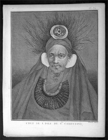
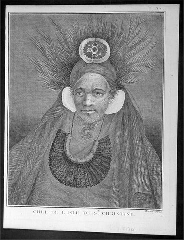
1778 Capt. Cook Antique Print Portrait Chief of Tahuata, Marquesas Isles in 1774
- Title : Chef De L Isle de Ste. Christine
- Ref : 16348
- Size: 10in x 8in (255mm x 205mm)
- Date : 1778
- Condition: (A+) Fine Condition
Description:
This fine original copper-plate engraved antique print, a portrait of Chief of Tahuata Island, Santa Cristina, in the Marquesas Islands, South Pacific, visited by Captain James Cook during his 2nd Voyage of Discovery in the South Seas in 1774, was engraved by Robert Benard - after William Hodges - and was published in the 1778 French edition of Capt. James Cooks 2nd Voyage of Discovery to the South Seas A voyage towards the South Pole, and round the World. Performed in His Majestys ships the Resolution and Adventure, in the years 1772, 1773, 1774, and 1775..... Paris : Hotel de Thou ......1778
Cook Diary (1774)
Apr. 7 Thu. Sights Hood’s Island (Fatu Huku), St. Pedro (Motare). La Dominica (Hiva Oa), St. Christina (Tahuata).
Apr 8 Fri. Sails along southern coast of Hiva Oa looking for anchorage. Anchors in Resolution (formerly Madre de Dios) Bay (Vaitahu Bay). Canoes arrive, gifts are exchanged. Natives killed after an iron stanchion is stolen.
Apr 9 Sat. Goes ashore, gifts exchanged, food obtained.
Apr 10 Sun. Goes ashore to south end of Bay and visits house of dead man. Gifts exchanged.
Apr 11 Mon. Goes ashore to south, again. Finds trade becoming expensive because of lavish gifts by his “gentlemen”.
Apr 12 Tue. Sails towards St. Dominica. No anchorage visible. Heads SW away from islands.
Apr 13 Wed. Sights last of the five main islands, Magdalena (Fatu Hiva).
General Definitions:
Paper thickness and quality: - Heavy and stable
Paper color : - off white
Age of map color: -
Colors used: -
General color appearance: -
Paper size: - 10in x 8in (255mm x 205mm)
Plate size: - 9 1/2in x 7 1/4in (240mm x 185mm)
Margins: - Min 1/2in (12mm)
Imperfections:
Margins: - Light soiling in margins
Plate area: - None
Verso: - None
Background:
Tahuata is the smallest of the inhabited Marquesas Islands, in French Polynesia, an overseas territory of France in the Pacific Ocean.
The first recorded sighting by Europeans was by the Spanish expedition of Álvaro de Mandaña on 22 July 1595. They charted the island as Santa Cristina. They landed at Vaitahu that they named Madre de Dios (Gods Mother in Spanish). According to the Spanish accounts Tahuata had fowls, fish, sugar cane, plantains, nuts and fruits. The existent town was built on two sides of a rectangular space, the houses being of timber and intertwined canes. A building which the Spaniards supposed to be a religious one stood outside the town, in a space enclosed by palisades, and containing some ill-carved images before which were offerings and provisions. The people had large and well constructed sailing canoes. Their tools were made of shells and fish bones. They used slings, stones, and lances as weapons.
Tahuata was visited by Captain James Cook in 1774 and Admiral Dupetit-Thouars in 1842, who signed the treaty annexing the Marquesas Islands to France.
The Marquesas Islands are a group of volcanic islands in French Polynesia, an overseas collective of France in the southern Pacific Ocean.
The first Europeans to reach the Marquesas may have been the crew of San Lesmes, a Spanish vessel which disappeared in a storm in June 1526; it was part of an expedition headed by García Jofre de Loaísa. The Spanish explorer Álvaro de Mendaña reached them seventy years later on 21 July 1595. He named them after his patron, García Hurtado de Mendoza, 5th Marquis of Cañete (Spanish: Marqués de Cañete), who served as Viceroy of Peru from 1590 to 1596. |Mendaña visited first Fatu Hiva and then Tahuata before continuing on to the Solomon Islands. His expedition charted the four southernmost Marquesas as Magdalena (Fatu Hiva), Dominica (Hiva ʻOa), San Pedro (Moho Tani), and Santa Cristina (Tahuata).
In the late 16th century European explorers estimated the population at more than 100,000. Europeans and Americans were impressed with how easy life appeared to be in the islands, which had a rich habitat and environment. In 1791 the American maritime fur trader Joseph Ingraham first visited the northern Marquesas while commanding the brig Hope. He named them the Washington Islands. In 1813 Commodore David Porter claimed Nuku Hiva for the United States, but the United States Congress never ratified that claim.
In 1842 France conducted a successful military operation on behalf of the native chief Iotete, who claimed he was king of the whole island of Tahuata. The government laid claim to the whole group and established a settlement on Nuku Hiva. That settlement was abandoned in 1857, but France re-established control over the group in 1870. It later incorporated the Marquesas into French Polynesia.
William Hodges RA 1744 – 1797 was an English painter. He was a member of James Cooks second voyage to the Pacific Ocean, and is best known for the sketches and paintings of locations he visited on that voyage, including Table Bay, Tahiti, Easter Island, and the Antarctic.
Between 1772 and 1775 Hodges accompanied James Cook to the Pacific as the expeditions artist. Many of his sketches and wash paintings were adapted as engravings in the original published edition of Cooks journals from the voyage.
Most of the large-scale landscape oil paintings from his Pacific travels for which Hodges is best known were finished after his return to London; he received a salary from the Admiralty for the purposes of completing them. These paintings depicted a stronger light and shadow than had been usual in European landscape tradition. Contemporary art critics complained that his use of light and colour contrasts gave his paintings a rough and unfinished appearance.
Hodges also produced many valuable portrait sketches of Pacific islanders and scenes from the voyage involving members of the expedition..
Robert Bénard 1734 – 1777 was an 18th-century French engraver.
Specialized in the technique of engraving, Robert Ménard is mainly famous for having supplied a significant amount of plates (at least 1,800) to the Encyclopédie by Diderot & d\'Alembert from 1751.
Later, publisher Charles-Joseph Panckoucke reused many of his productions to illustrate the works of his catalog.
1778 Capt. Cook Antique Print Portrait Chief of Tahuata, Marquesas Isles in 1774
- Title : Chef De L Isle de Ste. Christine
- Ref : 21328
- Size: 10in x 8in (255mm x 205mm)
- Date : 1778
- Condition: (A+) Fine Condition
Description:
This fine original copper-plate engraved antique print, a portrait of Chief of Tahuata Island, Santa Cristina, in the Marquesas Islands, South Pacific, visited by Captain James Cook during his 2nd Voyage of Discovery in the South Seas in 1774, was engraved by Robert Benard - after William Hodges - and was published in the 1778 French edition of Capt. James Cooks 2nd Voyage of Discovery to the South Seas A voyage towards the South Pole, and round the World. Performed in His Majestys ships the Resolution and Adventure, in the years 1772, 1773, 1774, and 1775..... Paris : Hotel de Thou ......1778
Cook Diary (1774)
Apr. 7 Thu. Sights Hood’s Island (Fatu Huku), St. Pedro (Motare). La Dominica (Hiva Oa), St. Christina (Tahuata).
Apr 8 Fri. Sails along southern coast of Hiva Oa looking for anchorage. Anchors in Resolution (formerly Madre de Dios) Bay (Vaitahu Bay). Canoes arrive, gifts are exchanged. Natives killed after an iron stanchion is stolen.
Apr 9 Sat. Goes ashore, gifts exchanged, food obtained.
Apr 10 Sun. Goes ashore to south end of Bay and visits house of dead man. Gifts exchanged.
Apr 11 Mon. Goes ashore to south, again. Finds trade becoming expensive because of lavish gifts by his “gentlemen”.
Apr 12 Tue. Sails towards St. Dominica. No anchorage visible. Heads SW away from islands.
Apr 13 Wed. Sights last of the five main islands, Magdalena (Fatu Hiva).
General Definitions:
Paper thickness and quality: - Heavy and stable
Paper color : - off white
Age of map color: -
Colors used: -
General color appearance: -
Paper size: - 10in x 8in (255mm x 205mm)
Plate size: - 9 1/2in x 7 1/4in (240mm x 185mm)
Margins: - Min 1/2in (12mm)
Imperfections:
Margins: - Light soiling in margins
Plate area: - None
Verso: - None
Background:
Tahuata is the smallest of the inhabited Marquesas Islands, in French Polynesia, an overseas territory of France in the Pacific Ocean.
The first recorded sighting by Europeans was by the Spanish expedition of Álvaro de Mandaña on 22 July 1595. They charted the island as Santa Cristina. They landed at Vaitahu that they named Madre de Dios (Gods Mother in Spanish). According to the Spanish accounts Tahuata had fowls, fish, sugar cane, plantains, nuts and fruits. The existent town was built on two sides of a rectangular space, the houses being of timber and intertwined canes. A building which the Spaniards supposed to be a religious one stood outside the town, in a space enclosed by palisades, and containing some ill-carved images before which were offerings and provisions. The people had large and well constructed sailing canoes. Their tools were made of shells and fish bones. They used slings, stones, and lances as weapons.
Tahuata was visited by Captain James Cook in 1774 and Admiral Dupetit-Thouars in 1842, who signed the treaty annexing the Marquesas Islands to France.
The Marquesas Islands are a group of volcanic islands in French Polynesia, an overseas collective of France in the southern Pacific Ocean.
The first Europeans to reach the Marquesas may have been the crew of San Lesmes, a Spanish vessel which disappeared in a storm in June 1526; it was part of an expedition headed by García Jofre de Loaísa. The Spanish explorer Álvaro de Mendaña reached them seventy years later on 21 July 1595. He named them after his patron, García Hurtado de Mendoza, 5th Marquis of Cañete (Spanish: Marqués de Cañete), who served as Viceroy of Peru from 1590 to 1596. |Mendaña visited first Fatu Hiva and then Tahuata before continuing on to the Solomon Islands. His expedition charted the four southernmost Marquesas as Magdalena (Fatu Hiva), Dominica (Hiva ʻOa), San Pedro (Moho Tani), and Santa Cristina (Tahuata).
In the late 16th century European explorers estimated the population at more than 100,000. Europeans and Americans were impressed with how easy life appeared to be in the islands, which had a rich habitat and environment. In 1791 the American maritime fur trader Joseph Ingraham first visited the northern Marquesas while commanding the brig Hope. He named them the Washington Islands. In 1813 Commodore David Porter claimed Nuku Hiva for the United States, but the United States Congress never ratified that claim.
In 1842 France conducted a successful military operation on behalf of the native chief Iotete, who claimed he was king of the whole island of Tahuata. The government laid claim to the whole group and established a settlement on Nuku Hiva. That settlement was abandoned in 1857, but France re-established control over the group in 1870. It later incorporated the Marquesas into French Polynesia.
William Hodges RA 1744 – 1797 was an English painter. He was a member of James Cooks second voyage to the Pacific Ocean, and is best known for the sketches and paintings of locations he visited on that voyage, including Table Bay, Tahiti, Easter Island, and the Antarctic.
Between 1772 and 1775 Hodges accompanied James Cook to the Pacific as the expeditions artist. Many of his sketches and wash paintings were adapted as engravings in the original published edition of Cooks journals from the voyage.
Most of the large-scale landscape oil paintings from his Pacific travels for which Hodges is best known were finished after his return to London; he received a salary from the Admiralty for the purposes of completing them. These paintings depicted a stronger light and shadow than had been usual in European landscape tradition. Contemporary art critics complained that his use of light and colour contrasts gave his paintings a rough and unfinished appearance.
Hodges also produced many valuable portrait sketches of Pacific islanders and scenes from the voyage involving members of the expedition..
Robert Bénard 1734 – 1777 was an 18th-century French engraver.
Specialized in the technique of engraving, Robert Ménard is mainly famous for having supplied a significant amount of plates (at least 1,800) to the Encyclopédie by Diderot & d\'Alembert from 1751.
Later, publisher Charles-Joseph Panckoucke reused many of his productions to illustrate the works of his catalog.
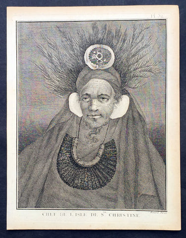
1778 Capt. Cook Antique Print Portrait Chief of Tahuata, Marquesas Isles in 1774
- Title : Chef De L Isle de Ste. Christine
- Ref : 31807
- Size: 10in x 8in (255mm x 205mm)
- Date : 1778
- Condition: (A+) Fine Condition
Description:
This fine original copper-plate engraved antique print, a portrait of Chief of Tahuata Island, Santa Cristina, in the Marquesas Islands, South Pacific, visited by Captain James Cook during his 2nd Voyage of Discovery in the South Seas in 1774, was engraved by Robert Benard - after William Hodges - and was published in the 1778 French edition of Capt. James Cooks 2nd Voyage of Discovery to the South Seas A voyage towards the South Pole, and round the World. Performed in His Majestys ships the Resolution and Adventure, in the years 1772, 1773, 1774, and 1775..... Paris : Hotel de Thou ......1778
Cook Diary (1774)
Apr. 7 Thu. Sights Hood’s Island (Fatu Huku), St. Pedro (Motare). La Dominica (Hiva Oa), St. Christina (Tahuata).
Apr 8 Fri. Sails along southern coast of Hiva Oa looking for anchorage. Anchors in Resolution (formerly Madre de Dios) Bay (Vaitahu Bay). Canoes arrive, gifts are exchanged. Natives killed after an iron stanchion is stolen.
Apr 9 Sat. Goes ashore, gifts exchanged, food obtained.
Apr 10 Sun. Goes ashore to south end of Bay and visits house of dead man. Gifts exchanged.
Apr 11 Mon. Goes ashore to south, again. Finds trade becoming expensive because of lavish gifts by his “gentlemen”.
Apr 12 Tue. Sails towards St. Dominica. No anchorage visible. Heads SW away from islands.
Apr 13 Wed. Sights last of the five main islands, Magdalena (Fatu Hiva).
General Definitions:
Paper thickness and quality: - Heavy and stable
Paper color : - off white
Age of map color: -
Colors used: -
General color appearance: -
Paper size: - 10in x 8in (255mm x 205mm)
Plate size: - 9 1/2in x 7 1/4in (240mm x 185mm)
Margins: - Min 1/2in (12mm)
Imperfections:
Margins: - Light soiling in margins
Plate area: - None
Verso: - None
Background:
Tahuata is the smallest of the inhabited Marquesas Islands, in French Polynesia, an overseas territory of France in the Pacific Ocean.
The first recorded sighting by Europeans was by the Spanish expedition of Álvaro de Mandaña on 22 July 1595. They charted the island as Santa Cristina. They landed at Vaitahu that they named Madre de Dios (Gods Mother in Spanish). According to the Spanish accounts Tahuata had fowls, fish, sugar cane, plantains, nuts and fruits. The existent town was built on two sides of a rectangular space, the houses being of timber and intertwined canes. A building which the Spaniards supposed to be a religious one stood outside the town, in a space enclosed by palisades, and containing some ill-carved images before which were offerings and provisions. The people had large and well constructed sailing canoes. Their tools were made of shells and fish bones. They used slings, stones, and lances as weapons.
Tahuata was visited by Captain James Cook in 1774 and Admiral Dupetit-Thouars in 1842, who signed the treaty annexing the Marquesas Islands to France.
The Marquesas Islands are a group of volcanic islands in French Polynesia, an overseas collective of France in the southern Pacific Ocean.
The first Europeans to reach the Marquesas may have been the crew of San Lesmes, a Spanish vessel which disappeared in a storm in June 1526; it was part of an expedition headed by García Jofre de Loaísa. The Spanish explorer Álvaro de Mendaña reached them seventy years later on 21 July 1595. He named them after his patron, García Hurtado de Mendoza, 5th Marquis of Cañete (Spanish: Marqués de Cañete), who served as Viceroy of Peru from 1590 to 1596. |Mendaña visited first Fatu Hiva and then Tahuata before continuing on to the Solomon Islands. His expedition charted the four southernmost Marquesas as Magdalena (Fatu Hiva), Dominica (Hiva ʻOa), San Pedro (Moho Tani), and Santa Cristina (Tahuata).
In the late 16th century European explorers estimated the population at more than 100,000. Europeans and Americans were impressed with how easy life appeared to be in the islands, which had a rich habitat and environment. In 1791 the American maritime fur trader Joseph Ingraham first visited the northern Marquesas while commanding the brig Hope. He named them the Washington Islands. In 1813 Commodore David Porter claimed Nuku Hiva for the United States, but the United States Congress never ratified that claim.
In 1842 France conducted a successful military operation on behalf of the native chief Iotete, who claimed he was king of the whole island of Tahuata. The government laid claim to the whole group and established a settlement on Nuku Hiva. That settlement was abandoned in 1857, but France re-established control over the group in 1870. It later incorporated the Marquesas into French Polynesia.
William Hodges RA 1744 – 1797 was an English painter. He was a member of James Cooks second voyage to the Pacific Ocean, and is best known for the sketches and paintings of locations he visited on that voyage, including Table Bay, Tahiti, Easter Island, and the Antarctic.
Between 1772 and 1775 Hodges accompanied James Cook to the Pacific as the expeditions artist. Many of his sketches and wash paintings were adapted as engravings in the original published edition of Cooks journals from the voyage.
Most of the large-scale landscape oil paintings from his Pacific travels for which Hodges is best known were finished after his return to London; he received a salary from the Admiralty for the purposes of completing them. These paintings depicted a stronger light and shadow than had been usual in European landscape tradition. Contemporary art critics complained that his use of light and colour contrasts gave his paintings a rough and unfinished appearance.
Hodges also produced many valuable portrait sketches of Pacific islanders and scenes from the voyage involving members of the expedition..
Robert Bénard 1734 – 1777 was an 18th-century French engraver.
Specialized in the technique of engraving, Robert Ménard is mainly famous for having supplied a significant amount of plates (at least 1,800) to the Encyclopédie by Diderot & d\'Alembert from 1751.
Later, publisher Charles-Joseph Panckoucke reused many of his productions to illustrate the works of his catalog.
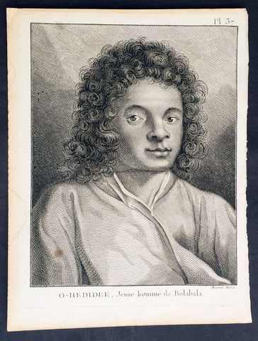
1778 Capt. Cook Antique Print Portrait of Oedidee, Bora Bora met by Cook in 1773
- Title : O-Hedidee, Jeune homme de Bolabala
- Ref : 31774
- Size: 10in x 8in (255mm x 205mm)
- Date : 1778
- Condition: (A+) Fine Condition
Description:
This fine original copper-plate engraved antique print, a portrait of O-Hedidee or Oedidee of the island of Bora Bora in the Society Islands, met by Captain James Cook during his 2nd Voyage of Discovery in the South Seas in 1773, was engraved by Robert Benard - after William Hodges - and was published in the 1778 French edition of Capt. James Cooks 2nd Voyage of Discovery to the South Seas A voyage towards the South Pole, and round the World. Performed in His Majestys ships the Resolution and Adventure, in the years 1772, 1773, 1774, and 1775..... Paris : Hotel de Thou ......1778
O-Hedidee or Oedidee, was a native of Bora Bora, Society Islands, French Polynesia, was about 17 or 18 years of age when he was taken on board the Resolution at Raiatea Island on 17 September 1773. He is described in Hawkesworths account as a young man with curly hair and flattish nose, wearing a gown. Cook wrote: he may be of use to us if we should fall in with and touch at any isles in our rout to the west which was my only motive for taking him on board. Cook Journals II.
O-Hedidee traveled with Cook from Raiatea to New Zealand, Easter Island, and Tahiti, returning to Raiatea on 4 June 1774, having been with the Resolutions company for seven months.
General Definitions:
Paper thickness and quality: - Heavy and stable
Paper color : - off white
Age of map color: -
Colors used: -
General color appearance: -
Paper size: - 10in x 8in (255mm x 205mm)
Plate size: - 9 1/2in x 7 1/4in (240mm x 185mm)
Margins: - Min 1/2in (12mm)
Imperfections:
Margins: - Light soiling in margins
Plate area: - None
Verso: - None
Background:
Bora Bora is a 30.55 km2 island group in the Leeward group in the western part of the Society Islands of French Polynesia, an overseas collective of France in the Pacific Ocean. The main island, located about 230 kilometres northwest of Papeete, Tahiti is surrounded by a lagoon and a barrier reef. In the center of the island are the remnants of an extinct volcano rising to two peaks, Mount Pahia and Mount Otemanu, the highest point at 727 metres
The island was inhabited by Polynesian settlers around the 4th century C.E. The first European sighting was made by Jakob Roggeveen in 1722.
James Cook sighted the island on 29 July 1769, using a Tahitian navigator, Tupaia. The London Missionary Society arrived in 1820 and founded a Protestant church in 1890. Bora Bora was an independent kingdom until 1888 when its last queen Teriimaevarua III was forced to abdicate by the French who annexed the island as a colony.
William Hodges RA 1744 – 1797 was an English painter. He was a member of James Cooks second voyage to the Pacific Ocean, and is best known for the sketches and paintings of locations he visited on that voyage, including Table Bay, Tahiti, Easter Island, and the Antarctic.
Between 1772 and 1775 Hodges accompanied James Cook to the Pacific as the expeditions artist. Many of his sketches and wash paintings were adapted as engravings in the original published edition of Cooks journals from the voyage.
Most of the large-scale landscape oil paintings from his Pacific travels for which Hodges is best known were finished after his return to London; he received a salary from the Admiralty for the purposes of completing them. These paintings depicted a stronger light and shadow than had been usual in European landscape tradition. Contemporary art critics complained that his use of light and colour contrasts gave his paintings a rough and unfinished appearance.
Hodges also produced many valuable portrait sketches of Pacific islanders and scenes from the voyage involving members of the expedition..
Robert Bénard 1734 – 1777 was an 18th-century French engraver.
Specialized in the technique of engraving, Robert Ménard is mainly famous for having supplied a significant amount of plates (at least 1,800) to the Encyclopédie by Diderot & d\'Alembert from 1751.
Later, publisher Charles-Joseph Panckoucke reused many of his productions to illustrate the works of his catalog.
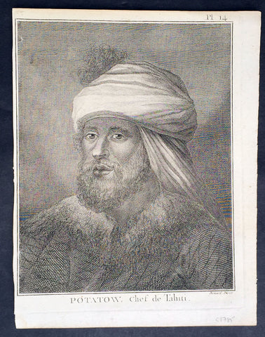
1778 Capt. Cook Antique Print Portrait of Chief Potatau of Punaauia, Tahiti 1773
- Title : Potatow, Chef de Tahiti
- Ref : 21415
- Size: 10in x 8in (255mm x 205mm)
- Date : 1778
- Condition: (A+) Fine Condition
Description:
This fine original copper-plate engraved antique print, a portrait of Chief Potatau of Punaauia in Tahiti, French Polynesia, met by Captain James Cook during his 2nd Voyage of Discovery in the South Seas in 1773, was engraved by Robert Benard - after William Hodges - and was published in the 1778 French edition of Capt. James Cooks 2nd Voyage of Discovery to the South Seas A voyage towards the South Pole, and round the World. Performed in His Majestys ships the Resolution and Adventure, in the years 1772, 1773, 1774, and 1775..... Paris : Hotel de Thou ......1778
Cooks Biography............George Vancouver (midshipman, of later fame) meanwhile, stayed behind to contemplate the role of the red feather in Tahitian society. It happened that Chief Potatau consulted with his wife on how they might obtain some of Cook\'s Oora and according to the plan that somehow reached Georges ears, she would go to Cook in his cabin and offer her services in return for said feathers. But the Captain was unswayed. It was just as well that Georges father was absent on this particular occasion, for he would only have been upset. As it was, his sleep was often disturbed by the sailors running all over the ship with their sexual partners at any hour of the night.
Such was Tahitian zeal for red feathers, Clerke remarked, that they gladly engaged in rather unhallow\'d rites for the sacred jewels in order to offer Propitiation to their Jolly Gods. Such was the maritime zeal for the Tahitian religion that the sailors fairly plundered the ship of its treasures; feathers were ripped from lovely Tongan garments and from delicate fretwork on coconuts; sailors even dyed plain feathers red. Thus valuable artifacts of the South Seas were undone. Nevertheless, among the treasures that came aboard were Potatau\'s monstrous helmets of war of five feet high and several handsome mourning dresses to become in due course part of the collections of ethnology in the Ashmolean Museum and the Bishop Museum. Besides the red feathers, the abundance of pork also attracted the girls; they consumed incredible quantities, reported George, because, as members of a poor class of Tahitians, they were denied pork in their own households. Such were the quantities they consumed, added George with a certain delicacy, that of a sudden they suffered the inconvenience of restlessness, and when they were refused the attention of their lovers, the very decks began to resemble the paths in the islands.........
General Definitions:
Paper thickness and quality: - Heavy and stable
Paper color : - off white
Age of map color: -
Colors used: -
General color appearance: -
Paper size: - 10in x 8in (255mm x 205mm)
Plate size: - 9 1/2in x 7 1/4in (240mm x 185mm)
Margins: - Min 1/2in (12mm)
Imperfections:
Margins: - Light soiling in margins
Plate area: - None
Verso: - None
Background:
Tahiti previously also known as Otaheite is the largest island in the Windward group of French Polynesia. The island is located in the archipelago of the Society Islands in the central Southern Pacific Ocean.
The first European to have visited Tahiti according to existing records was lieutenant Samuel Wallis, who was circumnavigating the globe in HMS Dolphin, sighting the island on 18 June 1767, and eventually harboring in Matavai Bay. This bay was situated on the territory of the chiefdom of Pare-Arue, governed by Tu (Tu-nui-e-a a-i-te-Atua) and his regent Tutaha, and the chiefdom of Ha apape, governed by Amo and his wife Oberea (Purea). Wallis named the island King Georges Island. The first contacts were difficult, since on the 24 and 26 June 1767, Tahitian warriors in canoes showed aggression towards the British, hurling stones from their slings. In retaliation, the British sailors opened fire on the warriors in the canoes and on the hills. In reaction to this powerful counter-attack, the Tahitians laid down peace offerings for the British. Following this episode, Samuel Wallis was able to establish cordial relations with the female chieftain “Oberea “ (Purea) and remained on the island until 27 July 1767.
In July 1768, Captain James Cook was commissioned by the Royal Society and on orders from the Lords Commissioners of the Admiralty to observe the transit of Venus across the sun, a phenomenon that would be visible from Tahiti on 3 June 1769. He arrived in Tahitis Matavai Bay, commanding the HMS Endeavour on 12 April 1769. On 14 April, Cook met with Tutaha and Tepau. On 15 April, Cook picked the site for a fortified camp at Point Venus along with Banks, Parkinson, Daniel Solander, to protect Charles Greens observatory. The length of stay enabled them to undertake for the first time real ethnographic and scientific observations of the island. Assisted by the botanist Joseph Banks, and by the artist Sydney Parkinson, Cook gathered valuable information on the fauna and flora, as well as the native society, language and customs, including the proper name of the island, Otaheite. On 28 April, Cook met Purea and Tupaia, and Tupaia befriended Banks following the transit. On 21 June, Amo visited Cook, and then on 25 June, Pohuetea visited, signifying another chief seeking to ally himself with the British.
Cook and Banks circumnavigated the island from 26 June to 1 July. On the exploration, they met Ahio, chief of Ha apaiano o or Papenoo, Rita, chief of Hitia a, Pahairro, chief of Pueu, Vehiatua, chief of Tautra, Matahiapo, chief of Teahupo o, Tutea, chief of Vaira o, and Moe, chief of Afa Ahiti. In Papara, guided by Tupaia, they investigated the ruins of Mahaiatea marae, an impressive structure containing a stone pyramid or ahu, measuring 44 feet high, 267 feet long and 87 feet wide. Cook and the Endeavour departed Tahiti on 13 July 1769, taking Raiatean navigator Tupaia along for his geographic knowledge of the islands.
Cook returned to Tahiti between 15 August and 1 September 1773, greeted by the chiefs Tai and Puhi, besides the youg ari i Vehiatua II and his stepfather Ti itorea. Cook anchored in Vaitepiha Bay before returning to Point Venus where he met Tu, the paramount chief. Cook picked up two passengers from Tahiti during this trip, Porea and Mai, with Hitihiti later replacing Porea when Cook stopped at Raiatea. Cook took Hitihiti to Tahiti on 22 April, during his return leg. Then, Cook departed Tahiti on 14 May 1774.
During his final visit, Cook returned Mai to Tahiti on 12 Aug. 1777, after Mais long visit in England. Cook also brought two Maori from Queen Charlotte Sound, Te Weherua and Koa. Cook first harbored in Vaitepiha Bay, where he visited Vehiatua II s funeral bier and the prefabricated Spanish mission house. Cook also met Vehiatua III, and inscribed on the back of the Spanish cross, Georgius tertius Rex Annis 1767, 69, 73, 74 & 77, as a counterpoint to Christus Vincit Carolus III imperat 1774 on the front. On 23 Aug., Cook sailed for Matavai Bay, where he met Tu, his father Teu, his mother Tetupaia, his brothers Ari ipaea and Vaetua, and his sisters Ari ipaea-vahine, Tetua-te-ahamai, and Auo. Cook also observed a human sacrifice, taata tapu, at the Utu-ai-mahurau marae, and 49 skulls from previous victims.
On 29 Sept. 1777, Cook sailed for Papetoai Bay on Moorea. Cook met Mahine in an act of friendship on 3 Oct., though he was an enemy of Tu. When a goat kid was stolen on 6 Oct., Cook in a rampage, ordered the burning of houses and canoes until it was returned. Cook sailed for Huahine on 11 Oct., Raiatea on 2 Nov., and Borabora on 7 Dec.
On 26 October 1788, HMS Bounty, under the command of Captain William Bligh, landed in Tahiti with the mission of carrying Tahitian breadfruit trees (Tahitian: uru) to the Caribbean. Sir Joseph Banks, the botanist from James Cooks first expedition, had concluded that this plant would be ideal to feed the African slaves working in the Caribbean plantations at very little cost. The crew remained in Tahiti for about five months, the time needed to transplant the seedlings of the trees. Three weeks after leaving Tahiti, on 28 April 1789, the crew mutinied on the initiative of Fletcher Christian. The mutineers seized the ship and set the captain and most of those members of the crew who remained loyal to him adrift in a ships boat. A group of mutineers then went back to settle in Tahiti.
Although various explorers had refused to get involved in tribal conflicts, the mutineers from the Bounty offered their services as mercenaries and furnished arms to the family which became the Pōmare Dynasty. The chief Tū knew how to use their presence in the harbours favoured by sailors to his advantage. As a result of his alliance with the mutineers, he succeeded in considerably increasing his supremacy over the island of Tahiti.
William Hodges RA 1744 – 1797 was an English painter. He was a member of James Cooks second voyage to the Pacific Ocean, and is best known for the sketches and paintings of locations he visited on that voyage, including Table Bay, Tahiti, Easter Island, and the Antarctic.
Between 1772 and 1775 Hodges accompanied James Cook to the Pacific as the expeditions artist. Many of his sketches and wash paintings were adapted as engravings in the original published edition of Cooks journals from the voyage.
Most of the large-scale landscape oil paintings from his Pacific travels for which Hodges is best known were finished after his return to London; he received a salary from the Admiralty for the purposes of completing them. These paintings depicted a stronger light and shadow than had been usual in European landscape tradition. Contemporary art critics complained that his use of light and colour contrasts gave his paintings a rough and unfinished appearance.
Hodges also produced many valuable portrait sketches of Pacific islanders and scenes from the voyage involving members of the expedition..
Robert Bénard 1734 – 1777 was an 18th-century French engraver.
Specialized in the technique of engraving, Robert Ménard is mainly famous for having supplied a significant amount of plates (at least 1,800) to the Encyclopédie by Diderot & d\'Alembert from 1751.
Later, publisher Charles-Joseph Panckoucke reused many of his productions to illustrate the works of his catalog.
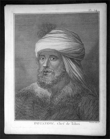
1778 Capt. Cook Antique Print Portrait of Chief Potatau of Punaauia, Tahiti 1773
- Title : Potatow, Chef de Tahiti
- Ref : 16353
- Size: 10in x 8in (255mm x 205mm)
- Date : 1778
- Condition: (A+) Fine Condition
Description:
This fine original copper-plate engraved antique print, a portrait of Chief Potatau of Punaauia in Tahiti, French Polynesia, met by Captain James Cook during his 2nd Voyage of Discovery in the South Seas in 1773, was engraved by Robert Benard - after William Hodges - and was published in the 1778 French edition of Capt. James Cooks 2nd Voyage of Discovery to the South Seas A voyage towards the South Pole, and round the World. Performed in His Majestys ships the Resolution and Adventure, in the years 1772, 1773, 1774, and 1775..... Paris : Hotel de Thou ......1778
Cooks Biography............George Vancouver (midshipman, of later fame) meanwhile, stayed behind to contemplate the role of the red feather in Tahitian society. It happened that Chief Potatau consulted with his wife on how they might obtain some of Cook\'s Oora and according to the plan that somehow reached Georges ears, she would go to Cook in his cabin and offer her services in return for said feathers. But the Captain was unswayed. It was just as well that Georges father was absent on this particular occasion, for he would only have been upset. As it was, his sleep was often disturbed by the sailors running all over the ship with their sexual partners at any hour of the night.
Such was Tahitian zeal for red feathers, Clerke remarked, that they gladly engaged in rather unhallow\'d rites for the sacred jewels in order to offer Propitiation to their Jolly Gods. Such was the maritime zeal for the Tahitian religion that the sailors fairly plundered the ship of its treasures; feathers were ripped from lovely Tongan garments and from delicate fretwork on coconuts; sailors even dyed plain feathers red. Thus valuable artifacts of the South Seas were undone. Nevertheless, among the treasures that came aboard were Potatau\'s monstrous helmets of war of five feet high and several handsome mourning dresses to become in due course part of the collections of ethnology in the Ashmolean Museum and the Bishop Museum. Besides the red feathers, the abundance of pork also attracted the girls; they consumed incredible quantities, reported George, because, as members of a poor class of Tahitians, they were denied pork in their own households. Such were the quantities they consumed, added George with a certain delicacy, that of a sudden they suffered the inconvenience of restlessness, and when they were refused the attention of their lovers, the very decks began to resemble the paths in the islands.........
General Definitions:
Paper thickness and quality: - Heavy and stable
Paper color : - off white
Age of map color: -
Colors used: -
General color appearance: -
Paper size: - 10in x 8in (255mm x 205mm)
Plate size: - 9 1/2in x 7 1/4in (240mm x 185mm)
Margins: - Min 1/2in (12mm)
Imperfections:
Margins: - Light soiling in margins
Plate area: - None
Verso: - None
Background:
Tahiti previously also known as Otaheite is the largest island in the Windward group of French Polynesia. The island is located in the archipelago of the Society Islands in the central Southern Pacific Ocean.
The first European to have visited Tahiti according to existing records was lieutenant Samuel Wallis, who was circumnavigating the globe in HMS Dolphin, sighting the island on 18 June 1767, and eventually harboring in Matavai Bay. This bay was situated on the territory of the chiefdom of Pare-Arue, governed by Tu (Tu-nui-e-a a-i-te-Atua) and his regent Tutaha, and the chiefdom of Ha apape, governed by Amo and his wife Oberea (Purea). Wallis named the island King Georges Island. The first contacts were difficult, since on the 24 and 26 June 1767, Tahitian warriors in canoes showed aggression towards the British, hurling stones from their slings. In retaliation, the British sailors opened fire on the warriors in the canoes and on the hills. In reaction to this powerful counter-attack, the Tahitians laid down peace offerings for the British. Following this episode, Samuel Wallis was able to establish cordial relations with the female chieftain “Oberea “ (Purea) and remained on the island until 27 July 1767.
In July 1768, Captain James Cook was commissioned by the Royal Society and on orders from the Lords Commissioners of the Admiralty to observe the transit of Venus across the sun, a phenomenon that would be visible from Tahiti on 3 June 1769. He arrived in Tahitis Matavai Bay, commanding the HMS Endeavour on 12 April 1769. On 14 April, Cook met with Tutaha and Tepau. On 15 April, Cook picked the site for a fortified camp at Point Venus along with Banks, Parkinson, Daniel Solander, to protect Charles Greens observatory. The length of stay enabled them to undertake for the first time real ethnographic and scientific observations of the island. Assisted by the botanist Joseph Banks, and by the artist Sydney Parkinson, Cook gathered valuable information on the fauna and flora, as well as the native society, language and customs, including the proper name of the island, Otaheite. On 28 April, Cook met Purea and Tupaia, and Tupaia befriended Banks following the transit. On 21 June, Amo visited Cook, and then on 25 June, Pohuetea visited, signifying another chief seeking to ally himself with the British.
Cook and Banks circumnavigated the island from 26 June to 1 July. On the exploration, they met Ahio, chief of Ha apaiano o or Papenoo, Rita, chief of Hitia a, Pahairro, chief of Pueu, Vehiatua, chief of Tautra, Matahiapo, chief of Teahupo o, Tutea, chief of Vaira o, and Moe, chief of Afa Ahiti. In Papara, guided by Tupaia, they investigated the ruins of Mahaiatea marae, an impressive structure containing a stone pyramid or ahu, measuring 44 feet high, 267 feet long and 87 feet wide. Cook and the Endeavour departed Tahiti on 13 July 1769, taking Raiatean navigator Tupaia along for his geographic knowledge of the islands.
Cook returned to Tahiti between 15 August and 1 September 1773, greeted by the chiefs Tai and Puhi, besides the youg ari i Vehiatua II and his stepfather Ti itorea. Cook anchored in Vaitepiha Bay before returning to Point Venus where he met Tu, the paramount chief. Cook picked up two passengers from Tahiti during this trip, Porea and Mai, with Hitihiti later replacing Porea when Cook stopped at Raiatea. Cook took Hitihiti to Tahiti on 22 April, during his return leg. Then, Cook departed Tahiti on 14 May 1774.
During his final visit, Cook returned Mai to Tahiti on 12 Aug. 1777, after Mais long visit in England. Cook also brought two Maori from Queen Charlotte Sound, Te Weherua and Koa. Cook first harbored in Vaitepiha Bay, where he visited Vehiatua II s funeral bier and the prefabricated Spanish mission house. Cook also met Vehiatua III, and inscribed on the back of the Spanish cross, Georgius tertius Rex Annis 1767, 69, 73, 74 & 77, as a counterpoint to Christus Vincit Carolus III imperat 1774 on the front. On 23 Aug., Cook sailed for Matavai Bay, where he met Tu, his father Teu, his mother Tetupaia, his brothers Ari ipaea and Vaetua, and his sisters Ari ipaea-vahine, Tetua-te-ahamai, and Auo. Cook also observed a human sacrifice, taata tapu, at the Utu-ai-mahurau marae, and 49 skulls from previous victims.
On 29 Sept. 1777, Cook sailed for Papetoai Bay on Moorea. Cook met Mahine in an act of friendship on 3 Oct., though he was an enemy of Tu. When a goat kid was stolen on 6 Oct., Cook in a rampage, ordered the burning of houses and canoes until it was returned. Cook sailed for Huahine on 11 Oct., Raiatea on 2 Nov., and Borabora on 7 Dec.
On 26 October 1788, HMS Bounty, under the command of Captain William Bligh, landed in Tahiti with the mission of carrying Tahitian breadfruit trees (Tahitian: uru) to the Caribbean. Sir Joseph Banks, the botanist from James Cooks first expedition, had concluded that this plant would be ideal to feed the African slaves working in the Caribbean plantations at very little cost. The crew remained in Tahiti for about five months, the time needed to transplant the seedlings of the trees. Three weeks after leaving Tahiti, on 28 April 1789, the crew mutinied on the initiative of Fletcher Christian. The mutineers seized the ship and set the captain and most of those members of the crew who remained loyal to him adrift in a ships boat. A group of mutineers then went back to settle in Tahiti.
Although various explorers had refused to get involved in tribal conflicts, the mutineers from the Bounty offered their services as mercenaries and furnished arms to the family which became the Pōmare Dynasty. The chief Tū knew how to use their presence in the harbours favoured by sailors to his advantage. As a result of his alliance with the mutineers, he succeeded in considerably increasing his supremacy over the island of Tahiti.
William Hodges RA 1744 – 1797 was an English painter. He was a member of James Cooks second voyage to the Pacific Ocean, and is best known for the sketches and paintings of locations he visited on that voyage, including Table Bay, Tahiti, Easter Island, and the Antarctic.
Between 1772 and 1775 Hodges accompanied James Cook to the Pacific as the expeditions artist. Many of his sketches and wash paintings were adapted as engravings in the original published edition of Cooks journals from the voyage.
Most of the large-scale landscape oil paintings from his Pacific travels for which Hodges is best known were finished after his return to London; he received a salary from the Admiralty for the purposes of completing them. These paintings depicted a stronger light and shadow than had been usual in European landscape tradition. Contemporary art critics complained that his use of light and colour contrasts gave his paintings a rough and unfinished appearance.
Hodges also produced many valuable portrait sketches of Pacific islanders and scenes from the voyage involving members of the expedition..
Robert Bénard 1734 – 1777 was an 18th-century French engraver.
Specialized in the technique of engraving, Robert Ménard is mainly famous for having supplied a significant amount of plates (at least 1,800) to the Encyclopédie by Diderot & d\'Alembert from 1751.
Later, publisher Charles-Joseph Panckoucke reused many of his productions to illustrate the works of his catalog.
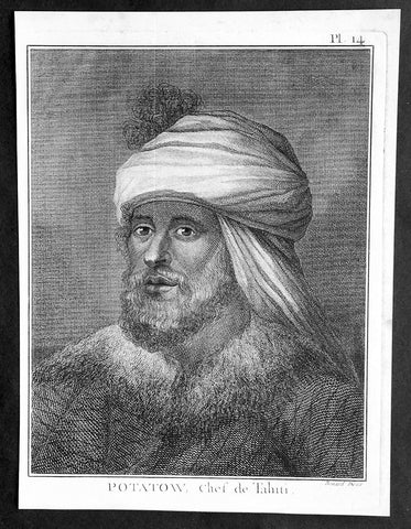
1778 Capt. Cook Antique Print Portrait of Chief Potatau of Punaauia, Tahiti 1773
- Title : Potatow, Chef de Tahiti
- Ref : 31772
- Size: 10in x 8in (255mm x 205mm)
- Date : 1778
- Condition: (A+) Fine Condition
Description:
This fine original copper-plate engraved antique print, a portrait of Chief Potatau of Punaauia in Tahiti, French Polynesia, met by Captain James Cook during his 2nd Voyage of Discovery in the South Seas in 1773, was engraved by Robert Benard - after William Hodges - and was published in the 1778 French edition of Capt. James Cooks 2nd Voyage of Discovery to the South Seas A voyage towards the South Pole, and round the World. Performed in His Majestys ships the Resolution and Adventure, in the years 1772, 1773, 1774, and 1775..... Paris : Hotel de Thou ......1778
Cooks Biography............George Vancouver (midshipman, of later fame) meanwhile, stayed behind to contemplate the role of the red feather in Tahitian society. It happened that Chief Potatau consulted with his wife on how they might obtain some of Cook\'s Oora and according to the plan that somehow reached Georges ears, she would go to Cook in his cabin and offer her services in return for said feathers. But the Captain was unswayed. It was just as well that Georges father was absent on this particular occasion, for he would only have been upset. As it was, his sleep was often disturbed by the sailors running all over the ship with their sexual partners at any hour of the night.
Such was Tahitian zeal for red feathers, Clerke remarked, that they gladly engaged in rather unhallow\'d rites for the sacred jewels in order to offer Propitiation to their Jolly Gods. Such was the maritime zeal for the Tahitian religion that the sailors fairly plundered the ship of its treasures; feathers were ripped from lovely Tongan garments and from delicate fretwork on coconuts; sailors even dyed plain feathers red. Thus valuable artifacts of the South Seas were undone. Nevertheless, among the treasures that came aboard were Potatau\'s monstrous helmets of war of five feet high and several handsome mourning dresses to become in due course part of the collections of ethnology in the Ashmolean Museum and the Bishop Museum. Besides the red feathers, the abundance of pork also attracted the girls; they consumed incredible quantities, reported George, because, as members of a poor class of Tahitians, they were denied pork in their own households. Such were the quantities they consumed, added George with a certain delicacy, that of a sudden they suffered the inconvenience of restlessness, and when they were refused the attention of their lovers, the very decks began to resemble the paths in the islands.........
General Definitions:
Paper thickness and quality: - Heavy and stable
Paper color : - off white
Age of map color: -
Colors used: -
General color appearance: -
Paper size: - 10in x 8in (255mm x 205mm)
Plate size: - 9 1/2in x 7 1/4in (240mm x 185mm)
Margins: - Min 1/2in (12mm)
Imperfections:
Margins: - Light soiling in margins
Plate area: - None
Verso: - None
Background:
Tahiti previously also known as Otaheite is the largest island in the Windward group of French Polynesia. The island is located in the archipelago of the Society Islands in the central Southern Pacific Ocean.
The first European to have visited Tahiti according to existing records was lieutenant Samuel Wallis, who was circumnavigating the globe in HMS Dolphin, sighting the island on 18 June 1767, and eventually harboring in Matavai Bay. This bay was situated on the territory of the chiefdom of Pare-Arue, governed by Tu (Tu-nui-e-a a-i-te-Atua) and his regent Tutaha, and the chiefdom of Ha apape, governed by Amo and his wife Oberea (Purea). Wallis named the island King Georges Island. The first contacts were difficult, since on the 24 and 26 June 1767, Tahitian warriors in canoes showed aggression towards the British, hurling stones from their slings. In retaliation, the British sailors opened fire on the warriors in the canoes and on the hills. In reaction to this powerful counter-attack, the Tahitians laid down peace offerings for the British. Following this episode, Samuel Wallis was able to establish cordial relations with the female chieftain “Oberea “ (Purea) and remained on the island until 27 July 1767.
In July 1768, Captain James Cook was commissioned by the Royal Society and on orders from the Lords Commissioners of the Admiralty to observe the transit of Venus across the sun, a phenomenon that would be visible from Tahiti on 3 June 1769. He arrived in Tahitis Matavai Bay, commanding the HMS Endeavour on 12 April 1769. On 14 April, Cook met with Tutaha and Tepau. On 15 April, Cook picked the site for a fortified camp at Point Venus along with Banks, Parkinson, Daniel Solander, to protect Charles Greens observatory. The length of stay enabled them to undertake for the first time real ethnographic and scientific observations of the island. Assisted by the botanist Joseph Banks, and by the artist Sydney Parkinson, Cook gathered valuable information on the fauna and flora, as well as the native society, language and customs, including the proper name of the island, Otaheite. On 28 April, Cook met Purea and Tupaia, and Tupaia befriended Banks following the transit. On 21 June, Amo visited Cook, and then on 25 June, Pohuetea visited, signifying another chief seeking to ally himself with the British.
Cook and Banks circumnavigated the island from 26 June to 1 July. On the exploration, they met Ahio, chief of Ha apaiano o or Papenoo, Rita, chief of Hitia a, Pahairro, chief of Pueu, Vehiatua, chief of Tautra, Matahiapo, chief of Teahupo o, Tutea, chief of Vaira o, and Moe, chief of Afa Ahiti. In Papara, guided by Tupaia, they investigated the ruins of Mahaiatea marae, an impressive structure containing a stone pyramid or ahu, measuring 44 feet high, 267 feet long and 87 feet wide. Cook and the Endeavour departed Tahiti on 13 July 1769, taking Raiatean navigator Tupaia along for his geographic knowledge of the islands.
Cook returned to Tahiti between 15 August and 1 September 1773, greeted by the chiefs Tai and Puhi, besides the youg ari i Vehiatua II and his stepfather Ti itorea. Cook anchored in Vaitepiha Bay before returning to Point Venus where he met Tu, the paramount chief. Cook picked up two passengers from Tahiti during this trip, Porea and Mai, with Hitihiti later replacing Porea when Cook stopped at Raiatea. Cook took Hitihiti to Tahiti on 22 April, during his return leg. Then, Cook departed Tahiti on 14 May 1774.
During his final visit, Cook returned Mai to Tahiti on 12 Aug. 1777, after Mais long visit in England. Cook also brought two Maori from Queen Charlotte Sound, Te Weherua and Koa. Cook first harbored in Vaitepiha Bay, where he visited Vehiatua II s funeral bier and the prefabricated Spanish mission house. Cook also met Vehiatua III, and inscribed on the back of the Spanish cross, Georgius tertius Rex Annis 1767, 69, 73, 74 & 77, as a counterpoint to Christus Vincit Carolus III imperat 1774 on the front. On 23 Aug., Cook sailed for Matavai Bay, where he met Tu, his father Teu, his mother Tetupaia, his brothers Ari ipaea and Vaetua, and his sisters Ari ipaea-vahine, Tetua-te-ahamai, and Auo. Cook also observed a human sacrifice, taata tapu, at the Utu-ai-mahurau marae, and 49 skulls from previous victims.
On 29 Sept. 1777, Cook sailed for Papetoai Bay on Moorea. Cook met Mahine in an act of friendship on 3 Oct., though he was an enemy of Tu. When a goat kid was stolen on 6 Oct., Cook in a rampage, ordered the burning of houses and canoes until it was returned. Cook sailed for Huahine on 11 Oct., Raiatea on 2 Nov., and Borabora on 7 Dec.
On 26 October 1788, HMS Bounty, under the command of Captain William Bligh, landed in Tahiti with the mission of carrying Tahitian breadfruit trees (Tahitian: uru) to the Caribbean. Sir Joseph Banks, the botanist from James Cooks first expedition, had concluded that this plant would be ideal to feed the African slaves working in the Caribbean plantations at very little cost. The crew remained in Tahiti for about five months, the time needed to transplant the seedlings of the trees. Three weeks after leaving Tahiti, on 28 April 1789, the crew mutinied on the initiative of Fletcher Christian. The mutineers seized the ship and set the captain and most of those members of the crew who remained loyal to him adrift in a ships boat. A group of mutineers then went back to settle in Tahiti.
Although various explorers had refused to get involved in tribal conflicts, the mutineers from the Bounty offered their services as mercenaries and furnished arms to the family which became the Pōmare Dynasty. The chief Tū knew how to use their presence in the harbours favoured by sailors to his advantage. As a result of his alliance with the mutineers, he succeeded in considerably increasing his supremacy over the island of Tahiti.
William Hodges RA 1744 – 1797 was an English painter. He was a member of James Cooks second voyage to the Pacific Ocean, and is best known for the sketches and paintings of locations he visited on that voyage, including Table Bay, Tahiti, Easter Island, and the Antarctic.
Between 1772 and 1775 Hodges accompanied James Cook to the Pacific as the expeditions artist. Many of his sketches and wash paintings were adapted as engravings in the original published edition of Cooks journals from the voyage.
Most of the large-scale landscape oil paintings from his Pacific travels for which Hodges is best known were finished after his return to London; he received a salary from the Admiralty for the purposes of completing them. These paintings depicted a stronger light and shadow than had been usual in European landscape tradition. Contemporary art critics complained that his use of light and colour contrasts gave his paintings a rough and unfinished appearance.
Hodges also produced many valuable portrait sketches of Pacific islanders and scenes from the voyage involving members of the expedition..
Robert Bénard 1734 – 1777 was an 18th-century French engraver.
Specialized in the technique of engraving, Robert Ménard is mainly famous for having supplied a significant amount of plates (at least 1,800) to the Encyclopédie by Diderot & d\'Alembert from 1751.
Later, publisher Charles-Joseph Panckoucke reused many of his productions to illustrate the works of his catalog.
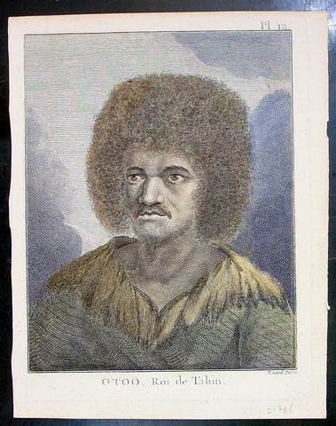
1774 Capt. Cook Antique Print a Portrait of Chief Tynah, Otoo of Tahiti in 1769
- Title : Otoo, Roi de Tahiti
- Ref : 21341
- Size: 10in x 8in (255mm x 205mm)
- Date : 1774
- Condition: (A+) Fine Condition
Description:
This fine original copper-plate engraved antique print a portrait of Chief Tynah (Otoo) of Tahiti Island, met by Captain James Cook during his 1st Voyage of Discovery in 1769, was engraved by Robert Benard - after Sydney Parkinson - and was published in the 1774 French edition of Capt. James Cooks 1st Voyage of Discovery to the South Seas by John Hawkesworth in An Account of the Voyages Undertaken by the Order of His Present Majesty for Making Discoveries in the Southern Hemisphere and Successively Performed by Commodore Byron, Captain Wallis, Captain Carteret, and Captain Cook, in the Dolphin, the Swallow, and the Endeavor, Drawn Up from the Journals Which Were Kept by the Several Commanders, and from the Papers of Joseph Banks. Paris, 1774.
General Definitions:
Paper thickness and quality: - Heavy and stable
Paper color : - off white
Age of map color: - Early
Colors used: - Yellow, brown, green
General color appearance: - Authentic
Paper size: - 10in x 8in (255mm x 205mm)
Plate size: - 9 1/2in x 7 1/4in (240mm x 185mm)
Margins: - Min 1/2in (12mm)
Imperfections:
Margins: - Light soiling in margins
Plate area: - None
Verso: - None
Background:
Tahiti previously also known as Otaheite is the largest island in the Windward group of French Polynesia. The island is located in the archipelago of the Society Islands in the central Southern Pacific Ocean.
The first European to have visited Tahiti according to existing records was lieutenant Samuel Wallis, who was circumnavigating the globe in HMS Dolphin, sighting the island on 18 June 1767, and eventually harboring in Matavai Bay. This bay was situated on the territory of the chiefdom of Pare-Arue, governed by Tu (Tu-nui-e-a a-i-te-Atua) and his regent Tutaha, and the chiefdom of Ha apape, governed by Amo and his wife Oberea (Purea). Wallis named the island King Georges Island. The first contacts were difficult, since on the 24 and 26 June 1767, Tahitian warriors in canoes showed aggression towards the British, hurling stones from their slings. In retaliation, the British sailors opened fire on the warriors in the canoes and on the hills. In reaction to this powerful counter-attack, the Tahitians laid down peace offerings for the British. Following this episode, Samuel Wallis was able to establish cordial relations with the female chieftain “Oberea “ (Purea) and remained on the island until 27 July 1767.
In July 1768, Captain James Cook was commissioned by the Royal Society and on orders from the Lords Commissioners of the Admiralty to observe the transit of Venus across the sun, a phenomenon that would be visible from Tahiti on 3 June 1769. He arrived in Tahitis Matavai Bay, commanding the HMS Endeavour on 12 April 1769. On 14 April, Cook met with Tutaha and Tepau. On 15 April, Cook picked the site for a fortified camp at Point Venus along with Banks, Parkinson, Daniel Solander, to protect Charles Greens observatory. The length of stay enabled them to undertake for the first time real ethnographic and scientific observations of the island. Assisted by the botanist Joseph Banks, and by the artist Sydney Parkinson, Cook gathered valuable information on the fauna and flora, as well as the native society, language and customs, including the proper name of the island, Otaheite. On 28 April, Cook met Purea and Tupaia, and Tupaia befriended Banks following the transit. On 21 June, Amo visited Cook, and then on 25 June, Pohuetea visited, signifying another chief seeking to ally himself with the British.
Cook and Banks circumnavigated the island from 26 June to 1 July. On the exploration, they met Ahio, chief of Ha apaiano o or Papenoo, Rita, chief of Hitia a, Pahairro, chief of Pueu, Vehiatua, chief of Tautra, Matahiapo, chief of Teahupo o, Tutea, chief of Vaira o, and Moe, chief of Afa Ahiti. In Papara, guided by Tupaia, they investigated the ruins of Mahaiatea marae, an impressive structure containing a stone pyramid or ahu, measuring 44 feet high, 267 feet long and 87 feet wide. Cook and the Endeavour departed Tahiti on 13 July 1769, taking Raiatean navigator Tupaia along for his geographic knowledge of the islands.
Cook returned to Tahiti between 15 August and 1 September 1773, greeted by the chiefs Tai and Puhi, besides the youg ari i Vehiatua II and his stepfather Ti itorea. Cook anchored in Vaitepiha Bay before returning to Point Venus where he met Tu, the paramount chief. Cook picked up two passengers from Tahiti during this trip, Porea and Mai, with Hitihiti later replacing Porea when Cook stopped at Raiatea. Cook took Hitihiti to Tahiti on 22 April, during his return leg. Then, Cook departed Tahiti on 14 May 1774.
During his final visit, Cook returned Mai to Tahiti on 12 Aug. 1777, after Mais long visit in England. Cook also brought two Maori from Queen Charlotte Sound, Te Weherua and Koa. Cook first harbored in Vaitepiha Bay, where he visited Vehiatua II s funeral bier and the prefabricated Spanish mission house. Cook also met Vehiatua III, and inscribed on the back of the Spanish cross, Georgius tertius Rex Annis 1767, 69, 73, 74 & 77, as a counterpoint to Christus Vincit Carolus III imperat 1774 on the front. On 23 Aug., Cook sailed for Matavai Bay, where he met Tu, his father Teu, his mother Tetupaia, his brothers Ari ipaea and Vaetua, and his sisters Ari ipaea-vahine, Tetua-te-ahamai, and Auo. Cook also observed a human sacrifice, taata tapu, at the Utu-ai-mahurau marae, and 49 skulls from previous victims.
On 29 Sept. 1777, Cook sailed for Papetoai Bay on Moorea. Cook met Mahine in an act of friendship on 3 Oct., though he was an enemy of Tu. When a goat kid was stolen on 6 Oct., Cook in a rampage, ordered the burning of houses and canoes until it was returned. Cook sailed for Huahine on 11 Oct., Raiatea on 2 Nov., and Borabora on 7 Dec.
On 26 October 1788, HMS Bounty, under the command of Captain William Bligh, landed in Tahiti with the mission of carrying Tahitian breadfruit trees (Tahitian: uru) to the Caribbean. Sir Joseph Banks, the botanist from James Cooks first expedition, had concluded that this plant would be ideal to feed the African slaves working in the Caribbean plantations at very little cost. The crew remained in Tahiti for about five months, the time needed to transplant the seedlings of the trees. Three weeks after leaving Tahiti, on 28 April 1789, the crew mutinied on the initiative of Fletcher Christian. The mutineers seized the ship and set the captain and most of those members of the crew who remained loyal to him adrift in a ships boat. A group of mutineers then went back to settle in Tahiti.
Although various explorers had refused to get involved in tribal conflicts, the mutineers from the Bounty offered their services as mercenaries and furnished arms to the family which became the Pōmare Dynasty. The chief Tū knew how to use their presence in the harbours favoured by sailors to his advantage. As a result of his alliance with the mutineers, he succeeded in considerably increasing his supremacy over the island of Tahiti.
Sydney Parkinson 1745 – 71 was draughtsman to the botanist Sir Joseph Banks on James Cook’s first voyage to the Pacific in 1768. He died of dysentery in 1771, on the homeward voyage.
Parkinson was the first European artist to create drawings of Indigenous Australian, Maori & South Sea peoples, as well as landscapes, from direct observation. Hundreds of his original drawings survive in the British Museum. He is particularly remembered for his plant illustrations which were later used to create the lavish plates for Joseph Banks’ Florilegium.
When the Endeavour returned to England in 1772, a dispute arose between Joseph Banks and Sydney’s brother, Stanfield Parkinson. As his employer, Banks claimed rights to Sydney’s drawings, papers and collections made on the voyage. Stanfield claimed that Sydney had willed them to his family. Banks lent the Parkinson family Sydney’s journal and drawings with instructions that they were not to be published, however Stanfield disregarded this and arranged for A Journal of a voyage to the South Seas to be printed from Sydney’s account of the voyage.
Banks managed to suppress Stanfield’s publication until the official account of the voyage, edited by John Hawkesworth, appeared. In return for Parkinson’s papers, Banks paid Stanfield Parkinson 500 pounds for balance of wages due to Sydney, but the dispute did not end there. Stanfield further accused Banks of retaining items collected by Sydney which were intended for his relatives. Stanfield Parkinson was declared insane soon after the publication of Sydney Parkinson’s Journal and died in an asylum.
John Hawkesworth An English writer and journalist, Hawkesworth was commissioned by the British Admiralty to edit for publication the narratives of its officers’ circumnavigations. He was given full access to the journals of the commanders and the freedom to adapt and re-tell them in the first person. Cook was already on his way back from his second Pacific voyage, temporarily docked at Cape Town (South Africa), when he first saw the published volumes: he was mortified and furious to find that Hawkesworth claimed in the introduction that Cook had seen and blessed (with slight corrections) the resulting manuscript. (In his defense, Hawkesworth also had been a victim of misunderstanding.) Cook had trouble recognizing himself. Moreover, the work was full of errors and commentary introduced by Hawkesworth and, in Cook’s view, too full of Banks, who had promoted himself and the publication. Still, the work was popular; the first edition sold out in several months.
Robert Bénard 1734 – 1777 was an 18th-century French engraver.
Specialized in the technique of engraving, Robert Ménard is mainly famous for having supplied a significant amount of plates (at least 1,800) to the Encyclopédie by Diderot & d\'Alembert from 1751.
Later, publisher Charles-Joseph Panckoucke reused many of his productions to illustrate the works of his catalog.
1837 Thomas Kelly Antique Map of Van Diemens Land - Tasmania, Australia
- Title : Van Diemens Land
- Ref #: 91205
- Size: 10 1/2in x 8 1/2in (265mm x 215mm)
- Date : 1837
- Condition: (A) Very Good Condition
Description:
This fine large original detailed antique map of Van Diemens Land or Tasmania, Australia was engraved in 1837 - dated at the foot of the map - and was published by Thomas Kelly for Barclays English Dictionary. (Ref: M&B; Tooley)
General Description:
Paper thickness and quality: - Light & stable
Paper color: - White
Age of map color: - Early
Colors used: - Green, yellow,
General color appearance: - Authentic
Paper size: - 10 1/2in x 8 1/2in (265mm x 215mm)
Plate size: - 10 1/2in x 8 1/2in (265mm x 215mm)
Margins: - Min 1/2in (10mm)
Imperfections:
Margins: - Left margin cropped to border
Plate area: - None
Verso: - None