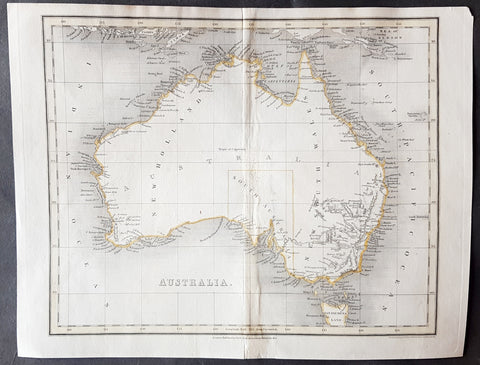
Australia/Oceania (117)

1817 John Thomson Large Antique Map of Asia, New Holland, Australia, New Zealand
- Title : Asia
- Date : 1817
- Size: 28in x 21in (710mm x 535mm)
- Condition: (A+) Fine Condition
- Ref: 92965
Description:
This large magnificent original hand coloured copper-plate engraved antique map of Asia, Australia, New Zealand & The South Pacific by John Thomson was published in the 1817 edition of Thomsons General Atlas
General Definitions:
Paper thickness and quality: - Heavy and stable
Paper color : - off white
Age of map color: - Original
Colors used: - Yellow, green, blue, pink
General color appearance: - Authentic
Paper size: - 28in x 21in (710mm x 535mm)
Plate size: - 22in x 19in (560mm x 485mm)
Margins: - Min 2in (50mm)
Imperfections:
Margins: - None
Plate area: - None
Verso: - None
Background:
The first recorded European sighting of the Australian mainland, and the first recorded European landfall on the Australian continent (in 1606), are attributed to the Dutch. The first ship and crew to chart the Australian coast and meet with Aboriginal people was the Duyfken captained by Dutch navigator, Willem Janszoon. He sighted the coast of Cape York Peninsula in early 1606, and made landfall on 26 February at the Pennefather River near the modern town of Weipa on Cape York. The Dutch charted the whole of the western and northern coastlines and named the island continent New Holland during the 17th century, but made no attempt at settlement. William Dampier, an English explorer and privateer, landed on the north-west coast of New Holland in 1688 and again in 1699 on a return trip. In 1770, James Cook sailed along and mapped the east coast, which he named New South Wales and claimed for Great Britain.
With the loss of its American colonies in 1783, the British Government sent a fleet of ships, the First Fleet, under the command of Captain Arthur Phillip, to establish a new penal colony in New South Wales. A camp was set up and the flag raised at Sydney Cove, Port Jackson, on 26 January 1788, a date which became Australias national day, Australia Day. A British settlement was established in Van Diemens Land, now known as Tasmania, in 1803, and it became a separate colony in 1825. The United Kingdom formally claimed the western part of Western Australia (the Swan River Colony) in 1828. Separate colonies were carved from parts of New South Wales: South Australia in 1836, Victoria in 1851, and Queensland in 1859. The Northern Territory was founded in 1911 when it was excised from South Australia. South Australia was founded as a free province—it was never a penal colony. Victoria and Western Australia were also founded free, but later accepted transported convicts. A campaign by the settlers of New South Wales led to the end of convict transportation to that colony; the last convict ship arrived in 1848.
The indigenous population, estimated to have been between 750,000 and 1,000,000 in 1788, declined for 150 years following settlement, mainly due to infectious disease. Thousands more died as a result of frontier conflict with settlers. A government policy of assimilation beginning with the Aboriginal Protection Act 1869 resulted in the removal of many Aboriginal children from their families and communities—often referred to as the Stolen Generations—a practice which may also have contributed to the decline in the indigenous population. As a result of the 1967 referendum, the Federal governments power to enact special laws with respect to a particular race was extended to enable the making of laws with respect to Aborigines.[68] Traditional ownership of land (native title) was not recognised in law until 1992, when the High Court of Australia held in Mabo v Queensland (No 2) that the legal doctrine that Australia had been terra nullius (land belonging to no one) did not apply to Australia at the time of British settlement.
A gold rush began in Australia in the early 1850s and the Eureka Rebellion against mining licence fees in 1854 was an early expression of civil disobedience. Between 1855 and 1890, the six colonies individually gained responsible government, managing most of their own affairs while remaining part of the British Empire. The Colonial Office in London retained control of some matters, notably foreign affairs, defence and international shipping.
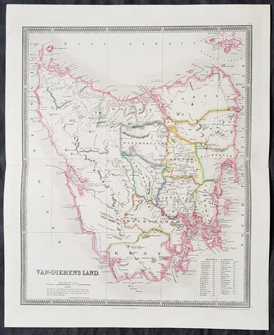
1835 Henry Teesdale Large Antique Map of Van Diemens Land, Tasmania, Australia
- Title : Van-Diemens Land
- Ref #: 80010
- Size: 19in x 15 1/2in (485mm x 395mm)
- Date : 1834
- Condition: (A+) Fine Condition
Description:
This fine beautifully hand coloured original antique map of Tasmania, Van-Diemens Land with the original 11 counties - was engraved by John Dower in 1834 and was published in the 1835 edition of Henry Teesdale's A New General Atlas of the World.
As with all the maps published by Teesdale this one is of the highest quality on strong clean & sturdy paper with beautiful original hand colouring. (Ref: M&B; Tooley)
General Definitions:
Paper thickness and quality: - Heavy and stable
Paper color : - off white
Age of map color: - Original
Colors used: - Yellow, green, blue, pink
General color appearance: - Authentic
Paper size: - 19in x 15 1/2in (485mm x 395mm)
Plate size: - 17 1/2in x 14 1/2in (445mm x 370mm)
Margins: - Min 1in (25mm)
Imperfections:
Margins: - None
Plate area: - None
Verso: - None
Background:
The first reported sighting of Tasmania by a European was on 24 November 1642 by the Dutch explorer Abel Tasman, who named the island Anthoonij van Diemenslandt, after his sponsor, the Governor of the Dutch East Indies. The name was later shortened to Van Diemen's Land by the British. In 1772, a French expedition led by Marc-Joseph Marion du Fresne landed on the island. Captain James Cook also sighted the island in 1777, and numerous other European seafarers made landfalls, adding a colourful array to the names of topographical features.
The first settlement was by the British at Risdon Cove on the eastern bank of the Derwent estuary in 1803, by a small party sent from Sydney, under Lt. John Bowen. An alternative settlement was established by Capt. David Collins 5 km to the south in 1804 in Sullivans Cove on the western side of the Derwent, where fresh water was more plentiful. The latter settlement became known as Hobart Town, later shortened to Hobart, after the British Colonial Secretary of the time, Lord Hobart. The settlement at Risdon was later abandoned.
Teesdale & co., Henry fl 1828-1843
Teesdale was a prominent London publisher and founding fellow of the Royal Geographical Society. He produced large-scale maps and charts and a number of fine atlases in the early part of the nineteenth century. He employed the most skilled draftsmen and engravers and his maps are renowned for precise detail and fine coloring
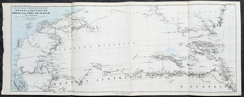
1876 Petermann Antique Map Western & South Australia - Warburton, Giles, Forrest
- Title : Die Neuesten Entdeckungsreisen im Inner-Australien von Warburton, Giles, Forrest, April 1873 - Sept 1874
- Size: 27in x 11in (285mm x 280mm)
- Condition: (A+) Fine Condition
- Date : 1876
- Ref #: 82055
Description:
This early folding original antique lithograph map of Western & South Australia and Alexandria land (Northern Territory) with the tracks of 3 explorers - in 1873 & 1874 - Peter Egerton-Warburton, Ernest Giles & Alexander Forrest by Augustus Heinrich Petermann was engraved in 1876 - dated - and was published by Justus Perthes, Gotha Germany.
General Definitions:
Paper thickness and quality: - Heavy and stable
Paper color : - off white
Age of map color: - Original
Colors used: - Blue, red, yellow
General color appearance: - Authentic
Paper size: - 27in x 11in (285mm x 280mm)
Plate size: - 27in x 11in (285mm x 280mm)
Margins: - Min 1/2in (12mm)
Imperfections:
Margins: - None
Plate area: - Folds as issued
Verso: - None
Background:
Colonel Peter Egerton-Warburton CMG (1813–1889), was a British military officer, Commissioner of Police for South Australia, and an Australian explorer. In 1872 he sealed his legacy through a particularly epic expedition from Adelaide crossing the arid centre of Australia to the coast of Western Australia via Alice Springs.
William Ernest Powell Giles (1835 – 1897) best known as Ernest Giles, was an Australian explorer who led five major expeditions in central Australia.
Alexander Forrest CMG (1849 – 1901) was an explorer and surveyor of Western Australia, and later also a member of parliament.
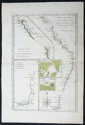
1785 Rigobert Bonne Antique Map of Australia, Botany Bay, Tasmania & Queensland
Antique Map
- Title : Nlle. Galles Merid. ou Cote Orientale de la Nouvelle Hollande Par M Bonne...Baie Botanique; Entree de la Riviere Endeavour; Esquisse de la Terre Van Diemen...
- Size: 17in x 11 1/2in (430mm x 285mm)
- Condition: (A+) Fine Condition
- Date : 1785
- Ref #: 93127
Description:
This original hand coloured antique copper-plate engraved map of the discoveries of Captain James Cook and the east coast of Australia in 1770 was published in 1785 edition of Atlas des toutes les parties connues du globe terrestre by Rigobert Bonne & Guillaume Raynal.
General Definitions:
Paper thickness and quality: - Heavy and stable
Paper color : - off white
Age of map color: - Original
Colors used: - Yellow, green, blue, pink
General color appearance: - Authentic
Paper size: - 17in x 11 1/2in (430mm x 285mm)
Plate size: - 14 1/2in x 10in (370mm x 255mm)
Margins: - Min 1/2in (12mm)
Imperfections:
Margins: - None
Plate area: - None
Verso: - None
Background:
Interesting map illustrating the discoveries in Australia by Captain Cook in 1770 and all the place names along the coastline. The map also 4 inset maps of Botany Bay, the Endeavour River QLD, the SE coast of Van Diemens Land or Tasmania and the northern coastline of QLD.
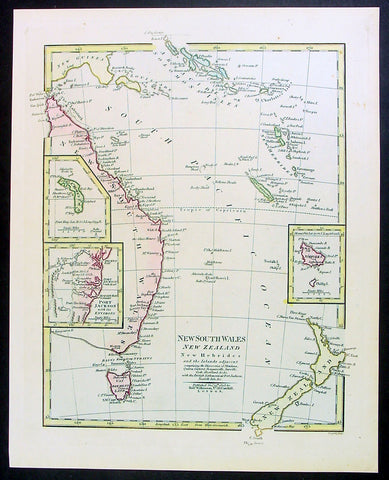
1808 Wilkinson Antique Map of East Coast of Australia, New Zealand, inset Sydney
- Title : New South Wales New Zealand New Hebrides...Published Dec 12th 1808
- Ref #: 9003
- Size: 13in x 11in (330mm x 280mm)
- Date : 1808
- Condition: (A+) Fine Condition
Description:
This fine beautifully hand coloured original antique map of the east coast of Australia, New Zealand and the Solomon Islands - with inset maps of Lord Howe Island, Norfolk Island & Port Jackson - was published in 1808 by Robert Wilkinson - the date is included in the title - in his wideley acclaimed General Atlas of the World published between 1794 and 1816.
This is a finely engraved copper-plate map with beautiful original hand colouring on strong stable paper. (Ref: Tooley; M&B)
General Description:
Paper thickness and quality: - Heavy and stable
Paper color: - off white
Age of map color: - Original
Colors used: - Yellow, green, pink, blue
General color appearance: - Authentic
Paper size: - 13in x 11in (330mm x 280mm)
Plate size: - 12 1/2in x 10in (320mm x 255mm)
Margins: - Min 1/2in (12mm)
Imperfections:
Margins: - None
Plate area: - None
Verso: - None
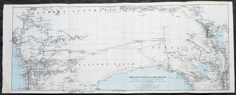
1876 Petermann Antique Map Expedition Ernest Giles Western & South Australia, 1875
- Title : Thomas Elders Expedition durch Inner-Australien vom Beltana im Osten bis Perth im Westen, Ausgefuhrt Durch E. Giles Mai - Nov 1875
- Size: 27in x 11in (285mm x 280mm)
- Condition: (A+) Fine Condition
- Date : 1876
- Ref #: 82054
Description:
This early folding original antique lithograph map of Western & South Australia - from Perth to Lake Torrens South Australia covering the 3rd & 4th expedition of the explorer Ernest Giles in 1875 by Augustus Heinrich Petermann was engraved in 1877 - dated - and was published by Justus Perthes, Gotha Germany.
General Definitions:
Paper thickness and quality: - Heavy and stable
Paper color : - off white
Age of map color: - Original
Colors used: - Blue, red, yellow
General color appearance: - Authentic
Paper size: - 27in x 11in (285mm x 280mm)
Plate size: - 27in x 11in (285mm x 280mm)
Margins: - Min 1/2in (12mm)
Imperfections:
Margins: - None
Plate area: - Folds as issued
Verso: - None
Background:
William Ernest Powell Giles 1835 – 1897 best known as Ernest Giles, was an Australian explorer who led five major expeditions in central Australia.
Giles did not attempt an organised expedition until 1872, when with two other men he left Chambers Pillar, South Australia (now in the Northern Territory), on 22 August and traversed much previously untrodden country to the north-west and west. Finding their way barred by Lake Amadeus and that their horses were getting very weak, a return was made to the Finke River and then to Charlotte Waters and Adelaide, where Giles arrived in January 1873. Giles looked upon his expedition as a failure, but he had done well considering the size and equipment of his party.
Giles friend Baron von Mueller raised a subscription so that a new expedition could be made. The services of William Tietkens as first assistant were obtained, and with two other men a start was made on 4 August 1873. The journey began considerably south from the previous expedition and from the Alberga River a generally western course was traversed. A month later in the Musgrave Ranges a fine running river was found and named the Ferdinand and by 3 October 1873 the party was approaching longitude 128 East. The country was extremely dry and though tested in various directions it was a constant struggle to get enough water to keep the horses going. Early in November, having passed longitude 126, a partial return was made and on 20 December 1873 the neighbourhood of Mount Scott was reached. A turn to the north and then west was made and the farthest westerly point was reached on 23 April 1874. Giles and one of the men, Alfred Gibson, had been scouting ahead when the latter\'s horse died. Giles gave him his own horse with instructions to follow their tracks back and obtain assistance. Giles made his way back to their depot on foot in eight days, almost completely exhausted, to find that Gibson had not reached the camp. A search was made for him for several days without success. The stores were almost finished, nothing further could be done, and on 21 May 1874 the return journey began. Giles named the desert Gibson Desert after his companion. On 24 June 1874 they were on a good track to the Finke River and on 13 July 1874 Charlotte Waters was reached. Giles had again failed to cross the continent, but in the circumstances all had been done that was possible.
Giles was the first European to see the rock formations of The Olgas, now known by their Aboriginal name of Kata Tjuta, and Lake Amadeus. He had wanted to name these Mt Mueller and Lake Ferdinand respectively, to honour his benefactor Baron Ferdinand von Mueller, however Mueller prevailed on him to instead honour the King Amadeus of Spain and Queen Olga of Württemberg. Giles supposedly discovered Uluru (formerly Ayers Rock), but was beaten to the claim by a competing explorer, William Gosse.
Early in 1875 Giles prepared his diaries for publication under the title Geographic Travels in Central Australia, and on 13 March 1875, with the generous help of Sir Thomas Elder, he began his third expedition. Proceeding considerably to the north from Fowler\'s Bay the country was found to be very dry. Retracing his steps Giles turned east, and eventually going round the north side of Lake Torrens reached Elder\'s station at Beltana. There the preparations for his fourth journey were made, and with Tietkens again his lieutenant, and with what Giles had always wanted, a caravan of camels, a start was made on 6 May. Port Augusta was reached on 23 May and, after taking a northerly course to clear the lakes, a generally westerly course was followed. Some water was carried, and the party was saved the continual excursions in search of water for horses that had caused so much difficulty during previous expeditions. Towards the end of September over 323 miles (520 km) had been covered in 17 days without finding water, when on 25 September the native Tommy found an abundant supply in a small hollow between sand dunes at Queen Victoria Spring, and the party was saved. After a rest of nine days the journey was resumed on 6 October the course being still west. Ten days later the expedition was attacked by a large body of aborigines and Giles was compelled to fire on them. On 4 November they met a white stockman at Tootra out-camp, east of Bindi Bindi. Their course was west to Walebing Station, then south-west and on 11 November they arrived at New Norcia where they were welcomed by Bishop Salvado. On 17 November 1875 the party arrived at Guildford and Perth the next day, where they received an enthusiastic reception.
Giles stayed for two months at Perth. Tietkens and Jess Young, another member of the expedition, went back to Adelaide by sea, and on 13 January 1876 Giles began the return journey taking a course generally about 400 miles north of the last journey. He arrived at Adelaide in September 1876 after a good journey during which the camels were found to be invaluable.
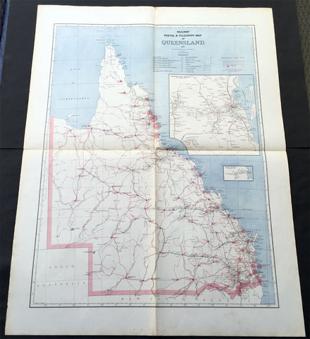
1888 Picturesque Atlas of Australia Large Antique Railway Map of Queensland
- Title : Railway Postal & Telegraph Map of Queensland
- Ref #: 50329
- Size: 34in x 26in (865mm x 660mm)
- Date : 1888
- Condition: (A+) Fine Condition
Description:
This very large fine original antique lithograph layered coloured map of Queensland showing the extent of Railway and postal lines, was engraved in 1888 - the date is engraved in the title - with index page - by Alex J Scally - was published in the extremely significant Australian & New Zealand publication The Picturesque Atlas of Australasia between 1886-88.
These maps were some of the best maps published at the time in the "Modern" look. The colour is bright, the engraving extremely fine and the paper heavy and stable.
General Description:
Paper thickness and quality: - Light & stable
Paper color: - White
Age of map color: - Original
Colors used: - Blue, red
General color appearance: - Authentic
Paper size: - 34in x 26in (865mm x 660mm)
Plate size: - 34in x 26in (865mm x 660mm)
Margins: - Min 1in (25mm)
Imperfections:
Margins: - None
Plate area: - Folds as issued
Verso: - None
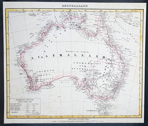
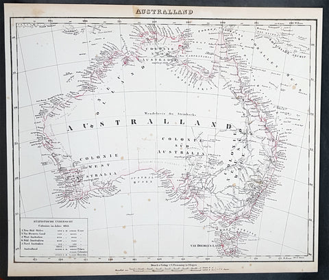
1845 Handtke & Flemming Large Antique Map of Australia - Population of 213,500
- Title : Australland...1841
- Date : 1845
- Condition: (A) Very Good Condition
- Ref: 31977
- Size: 16in x 14in (405mm x 355mm)
Description:
This hand coloured original steel-plate engraved antique highly detailed map of Australia, with a population census of the entire country in 1841, by Friedrich Handtke in 1845, was published in the Complete hand atlas of the recent description of the earth over all parts of the earth, Carl Flemming, Glougau.
General Definitions:
Paper thickness and quality: - Heavy and stable
Paper color : - off white
Age of map color: - Original
Colors used: - Yellow, red
General color appearance: - Authentic
Paper size: - 16in x 14in (405mm x 355mm)
Plate size: - 16in x 14in (405mm x 355mm)
Margins: - Min 1/2in (12mm)
Imperfections:
Margins: - Age toning & spotting
Plate area: - Age toning & spotting
Verso: - Age toning & spotting
Background:
Australia is a sovereign country comprising the mainland of the Australian continent, the island of Tasmania and numerous smaller islands. It is the largest country in Oceania and the world\'s sixth-largest country by total area. The neighbouring countries are Papua New Guinea, Indonesia and East Timor to the north; the Solomon Islands and Vanuatu to the north-east; and New Zealand to the south-east. The population of 25 million is highly urbanised and heavily concentrated on the eastern seaboard. Australias capital is Canberra, and its largest city is Sydney. The country\'s other major metropolitan areas are Melbourne, Brisbane, Perth and Adelaide.
Australia was inhabited by indigenous Australians for about 60,000 years before the first British settlement in the late 18th century. It is documented that Aborigines spoke languages that can be classified into about 250 groups. After the European discovery of the continent by Dutch explorers in 1606, who named it New Holland, Australia\'s eastern half was claimed by Great Britain in 1770 and initially settled through penal transportation to the colony of New South Wales from 26 January 1788, a date which became Australia\'s national day. The population grew steadily in subsequent decades, and by the 1850s most of the continent had been explored and an additional five self-governing crown colonies established. On 1 January 1901, the six colonies federated, forming the Commonwealth of Australia. Australia has since maintained a stable liberal democratic political system that functions as a federal parliamentary constitutional monarchy comprising six states and ten territories.
Being the oldest, flattest and driest inhabited continent, with the least fertile soils, Australia has a landmass of 7,617,930 square kilometres. A megadiverse country, its size gives it a wide variety of landscapes, with deserts in the centre, tropical rainforests in the north-east and mountain ranges in the south-east. A gold rush began in Australia in the early 1850s, which boosted the population of the country. Nevertheless, its population density, 2.8 inhabitants per square kilometre, remains among the lowest in the world. Australia generates its income from various sources including mining-related exports, telecommunications, banking and manufacturing. Indigenous Australian rock art is the oldest and richest in the world, dating as far back as 60,000 years and spread across hundreds of thousands of sites.
The first recorded European sighting of the Australian mainland, and the first recorded European landfall on the Australian continent (in 1606), are attributed to the Dutch. The first ship and crew to chart the Australian coast and meet with Aboriginal people was the Duyfken captained by Dutch navigator, Willem Janszoon. He sighted the coast of Cape York Peninsula in early 1606, and made landfall on 26 February at the Pennefather River near the modern town of Weipa on Cape York. The Dutch charted the whole of the western and northern coastlines and named the island continent New Holland during the 17th century, but made no attempt at settlement. William Dampier, an English explorer and privateer, landed on the north-west coast of New Holland in 1688 and again in 1699 on a return trip. In 1770, James Cook sailed along and mapped the east coast, which he named New South Wales and claimed for Great Britain.
With the loss of its American colonies in 1783, the British Government sent a fleet of ships, the First Fleet, under the command of Captain Arthur Phillip, to establish a new penal colony in New South Wales. A camp was set up and the flag raised at Sydney Cove, Port Jackson, on 26 January 1788, a date which became Australia\'s national day, Australia Day. A British settlement was established in Van Diemens Land, now known as Tasmania, in 1803, and it became a separate colony in 1825. The United Kingdom formally claimed the western part of Western Australia (the Swan River Colony) in 1828. Separate colonies were carved from parts of New South Wales: South Australia in 1836, Victoria in 1851, and Queensland in 1859. The Northern Territory was founded in 1911 when it was excised from South Australia. South Australia was founded as a free province—it was never a penal colony. Victoria and Western Australia were also founded free, but later accepted transported convicts. A campaign by the settlers of New South Wales led to the end of convict transportation to that colony; the last convict ship arrived in 1848.
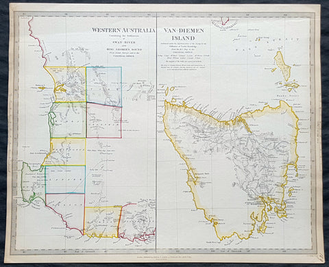
1833 SDUK Antique Map of Western Australia, Swan River Colony & Van Diemens Land
- Title : Western Australia containing the settlment of Swan River and King Georges Sound; Van-Diemens Land
- Size: 16in x 14in (410mm x 355m)
- Condition: (A+) Fine Condition
- Date : 1833
- Ref #: 31974
Description:
This fine hand coloured original antique map of Western Australia - only 4 years after the first British settlement on the Swan river & Van Diemens Land or Tasmania was engraved by J & C Walker, in 1833 - the date is engraved at the foot of the map - and was published in the Baldwin & Craddock edition of the Society For the Diffusion of Useful Knowledge (SDUK) Atlas.
General Definitions:
Paper thickness and quality: - Heavy and stable
Paper color : - off white
Age of map color: - Original
Colors used: - Red, pink
General color appearance: - Authentic
Paper size: - 16in x 14in (410mm x 355m)
Plate size: - 16in x 14in (410mm x 355m)
Margins: - Min 1/2in (10mm)
Imperfections:
Margins: - Light age toning
Plate area: - None
Verso: - None
Background:
The SDUK produced two landmark volumes of cartography in the first half of the 19th century. The first volume concentrated on areas of the old world, Europe, Africa, Great Britain etc. The second volume contained maps of the new world, America, South Asia, including US state maps, colonies of Australia, South Africa, South America etc. Also included were some of the finest engraved town and city plans published at that time.
The SDUK was published in its entirety or in part by many publishers including Baldwin and Cradock 1829-32, Chapman & Hall in 1844, Charles Knight & co. 1846 – 1852. G. Cox published the SDUK between 1852-3, Stanford 1857-70 and later revised edition were also published after Stanford. (Ref: Tooley, M&B)
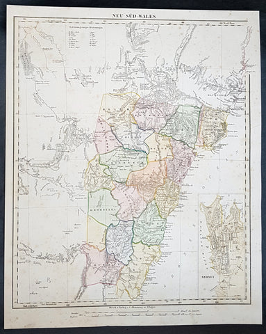
1854 Handtke & Flemming Large Antique Map of New South Wales, Sydney, Australia
- Title : Neu Sud-Wales
- Date : 1854
- Condition: (A) Very Good Condition
- Ref: 31992
- Size: 17in x 14in (430mm x 355mm)
Description:
This beautifully hand coloured original steel-plate engraved antique map of New South Wales, with an inset of a plan of Sydney Town by Friedrich Handtke in 1854, was published in the Complete hand atlas of the recent description of the earth over all parts of the earth, Carl Flemming, Glougau.
General Definitions:
Paper thickness and quality: - Heavy and stable
Paper color : - off white
Age of map color: - Original
Colors used: - Yellow, green, blue, pink
General color appearance: - Authentic
Paper size: - 17in x 14in (430mm x 355mm)
Plate size: - 17in x 14in (430mm x 355mm)
Margins: - Min 1/2in (12mm)
Imperfections:
Margins: - Light age toning
Plate area: - Light age toning
Verso: - Light age toning
Background:
A golden age of a new kind began in New South Wales and Sydney in 1851 with the announcement of the discovery of payable gold at Ophir near Bathurst by Edward Hargraves. In that year New South Wales had about 200,000 people, a third of them within a days ride of Sydney, the rest scattered along the coast and through the pastoral districts, from the Port Phillip District in the south to Moreton Bay in the north. The gold rushes of the 1850s brought a huge influx of settlers, although initially the majority of them went to the richest gold fields at Ballarat and Bendigo, in the Port Phillip District, which in 1851 was separated to become the colony of Victoria.
Hill End, also near Bathurst N.S.W. was a locality that grew, boomed and faded with the N.S.W. Gold Rush. Called \'Bald Hills\' in 1850, \'Forbes in 1860 and finally Hill End in 1862, it was part of the Tambaroora district. At its peak, its population was 7,000. Completely reliant on mining, the town\'s decline was dramatic once the gold ran out. Hill End is famed for the unearthing of the Holtermann Specimen (correctly, the Beyers Holtermann Specimen), being the largest single mass of gold ever discovered in the world, a record that stands today. Found in 1872 at the Star Hope Mine, this single mass of quartz and gold weighed 630 lbs and when crushed produced an estimated 3,000 troy oz (205 lbs or 93 kg) of gold, thus holding more processed gold than from the largest nugget ever found, that being the Welcome Stranger from the Victorian Goldfields. Holtermann recognizing the significance of the find attempted to preserve it by buying it from the Company of which he was one of a number of directors. His efforts were in vain. It is reported that a larger mass was discovered a few days later in the same mine but was broken up underground.
Victoria soon had a larger population than New South Wales, and its upstart capital, Melbourne, outgrew Sydney. But the New South Wales gold fields also attracted a flood of prospectors, and by 1857 the colony had more than 300,000 people. Inland towns like Bathurst, Goulburn, Orange and Young flourished. Gold brought great wealth but also new social tensions. Multiethnic migrants came to New South Wales in large numbers for the first time. Young became the site of an infamous anti-Chinese miner riot in 1861 and the official Riot Act was read to the miners on 14 July – the only official reading in the history of New South Wales.[27] Despite some tension, the influx of migrants also brought fresh ideas from Europe and North America to New South Wales – Norwegians introduced Skiing in Australia to the hills above the Snowy Mountains gold rush town of Kiandra around 1861. A famous Australian son was also born to a Norwegian miner in 1867, when the bush balladeer Henry Lawson was born at the Grenfell goldfields.
In 1858, a new gold rush began in the far north, which led in 1859 to the separation of Queensland as a new colony. New South Wales thus attained its present borders, although what is now the Northern Territory remained part of the colony until 1863, when it was handed over to South Australia.
The separation and rapid growth of Victoria and Queensland mark the real beginning of New South Wales as a political and economic entity distinct from the other Australian colonies. Rivalry between New South Wales and Victoria was intense throughout the second half of the 19th century, and the two colonies developed in radically different directions. Once the easy gold ran out by about 1860, Victoria absorbed the surplus labour force from the gold fields in manufacturing, protected by high tariff walls. Victoria became the Australian stronghold of protectionism, liberalism and radicalism. New South Wales, which was less radically affected demographically by the gold rushes, remained more conservative, still dominated politically by the squatter class and its allies in the Sydney business community. New South Wales, as a trading and exporting colony, remained wedded to free trade.
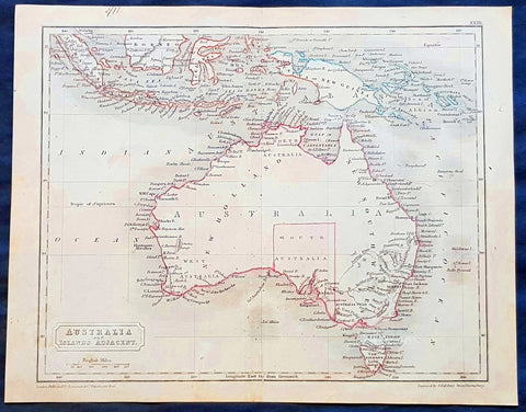
1830 Sydney Hall Antique Map of Australia, New Holland, Swan River Settlement
- Title : Australia & Islands Adjacent
- Ref #: 35074
- Size: 10 1/2in x 8 1/2in (265mm x 210mm)
- Date : 1830
- Condition: (A) Very Good Condition
Description:
This original hand coloured copper-plate original antique map by Sydney Hall was published in the 1830 edition of Halls General Atlas published by Longman & co., London. (Ref: Tooley; M&B)
General Definitions:
Paper thickness and quality: - Heavy and stable
Paper color : - off white
Age of map color: -
Colors used: -
General color appearance: -
Paper size: - 10 1/2in x 8 1/2in (265mm x 210mm)
Plate size: - 10 1/2in x 8 1/2in (265mm x 210mm)
Margins: - Min 1/2in (12mm)
Imperfections:
Margins: - None
Plate area: - Folds as issued
Verso: - None
Background:
The first recorded European sighting of the Australian mainland, and the first recorded European landfall on the Australian continent (in 1606), are attributed to the Dutch. The first ship and crew to chart the Australian coast and meet with Aboriginal people was the Duyfken captained by Dutch navigator, Willem Janszoon. He sighted the coast of Cape York Peninsula in early 1606, and made landfall on 26 February at the Pennefather River near the modern town of Weipa on Cape York. The Dutch charted the whole of the western and northern coastlines and named the island continent New Holland during the 17th century, but made no attempt at settlement. William Dampier, an English explorer and privateer, landed on the north-west coast of New Holland in 1688 and again in 1699 on a return trip. In 1770, James Cook sailed along and mapped the east coast, which he named New South Wales and claimed for Great Britain.
With the loss of its American colonies in 1783, the British Government sent a fleet of ships, the First Fleet, under the command of Captain Arthur Phillip, to establish a new penal colony in New South Wales. A camp was set up and the flag raised at Sydney Cove, Port Jackson, on 26 January 1788, a date which became Australia\'s national day, Australia Day. A British settlement was established in Van Diemens Land, now known as Tasmania, in 1803, and it became a separate colony in 1825. The United Kingdom formally claimed the western part of Western Australia (the Swan River Colony) in 1828. Separate colonies were carved from parts of New South Wales: South Australia in 1836, Victoria in 1851, and Queensland in 1859. The Northern Territory was founded in 1911 when it was excised from South Australia. South Australia was founded as a free province—it was never a penal colony. Victoria and Western Australia were also founded free, but later accepted transported convicts. A campaign by the settlers of New South Wales led to the end of convict transportation to that colony; the last convict ship arrived in 1848.
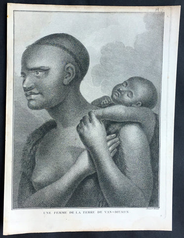
1785 Capt. Cook Antique Print Aboriginal Woman of Bruny Island, Tasmania in 1777
- Title : Une Femme De La Terre De Van-Diemens
- Ref : 50609
- Size: 10in x 8in (255mm x 205mm)
- Date : 1785
- Condition: (A+) Fine Condition
Description:
This fine original copper-plate engraved antique print of an Indigenous Woman & child of Adventure Bay, Bruny Island, Tasmania (Van Diemens Land) encountered by Captain Cook in during his 3rd & last Voyage of Discovery in 1777, was engraved by Robert Benard - after John Webber - and published in the 1785 French edition of Capt. James Cook & Capt. James King A Voyage to the Pacific Ocean. Undertaken, by the Command of his Majesty, for making Discoveries in the Northern Hemisphere. To determine The Position and Extent of the West Side of North America; its Distance from Asia; and the Practicability of a Northen Passage to Europe. Performed under the direction of Captains Cook, Clerke, and Gore, In His Majesty\'s Ships the Resolution and Discovery. In the Years 1776, 1777, 1778, 1779, and 1780. In Three Volumes. Vol. I and II written by James Cook, F.R.S. Vol. III by Captain James King, LL.D. and F.R.S. Paris, 1785.
Adventure Bay
from Cooks Journal......on the 24th (March 1777) at 3 AM we made the Coast of Van Diemen land wrote Cook. Anderson remarked that though now the middle of summer here a spot or two of snow was seen on the highest hills… At ten we passd a point supposd to be the boundary of Stone Bay where Abel Tasman anchord, i.e. Storm Bay. According to David Samwell, surgeons first mate on the Resolution, both Ships anchored in Adventure Bay in Van Diemens Land, this Bay was so called by Captn Furneaux who had anchored here in the Adventure last Voyage.
The next day Cook and Clerke sent parties, one to cut wood and the other grass. Clerke wrote of his party from the Discovery The Guard I had sent with the Parties on shore which consisted of the following Marines, Hamlet Thompson, Geo: Moody, Ben: Harriot, Jos: Pool & Willm Broom, stole some Liquor & made themselves exceedingly drunk, for which they receivd a dozen lashes each in the Morning. The Privates were all from the Plymouth division of marines. Hamlet Thompson was from the 6th Company, George Moody from the 70th, John Herriott the 12th, James Poole the 33rd and William Broom the 36th. According to Thomas Edgar, Master, they made themselves so Beastly Drunk that they were put motionless in the Boat, and when brought on board were oblig\'d to be hoisted into the Ship.
William Bayly, astronomer on the Discovery, wrote In the morning I carried my Tent observatory & Instruments on Shore & set all up, but was not able to get any observations it being cloudy all day, in the evening Capt Cook Sent for me & told me he had Altered his mind relative to his stay, & ordered me to pack all up & carry the whole on board again, as he intend[ed] to sail for New Zealand in a day or two.
John Henry Martin, seaman on the Discovery, described the natives. They have few, or no wants, & seemed perfectly Happy, if one might judge from their behaviour, for they frequently woud burst out, into the most immoderate fits of Laughter & when one Laughed every one followed his example Emediately.
General Definitions:
Paper thickness and quality: - Heavy and stable
Paper color : - off white
Age of map color: -
Colors used: -
General color appearance: -
Paper size: - 10in x 8in (255mm x 205mm)
Plate size: - 9 1/2in x 7 1/4in (240mm x 185mm)
Margins: - Min 1/2in (12mm)
Imperfections:
Margins: - None
Plate area: - None
Verso: - None
Background:
Adventure Bay is the name of both a township and a geographical feature on the eastern side of Bruny Island, Tasmania.
The first European to sight the bay was explorer Abel Tasman, who sought to anchor his vessel Heemskerck there in 1642. Instead, Heemskerck was driven back offshore by a storm, in token of which Tasman named the place Storm Bay. Captain Tobias Furneaux renamed it in March 1773, in honour of his ship HMS Adventure, which he had anchored in the bay for five days after becoming separated from Captain James Cook\'s HMS Resolution during Cook\'s second voyage to the Pacific search of Terra Australis Incognita. Furneaux\'s log made clear the bay was an excellent anchorage for resupplying vessels:....to the SW of the first watering place there is a large lagoon which I believe has plenty of fish in it for one of our Gentlemen caught upwards of 2 dozen trout, and shot a possum which was the only animal we saw. There are a great many gum trees and of a vast thickness and height, one of which measured in circumference 26 feet and the height under the branches was 20 feet.
Others among Furneaux\'s crew spotted evidence of what they believed were small deer but were more likely kangaroos. Furneaux also noted signs of an Aboriginal settlement in the form of several huts or wigwams on shore, with several bags of grass in which they carry their shellfish. - but the branches of which the huts were made were split and torn and there was not the least appearance of any people.
Reliably mapped and offering an abundance of water, fresh water and game, Adventure Bay quickly became a popular anchorage for European explorers. Cooks Resolution watered there in 1777, followed by William Bligh aboard HMS Bounty in 1788 and HMS Providence in 1792. Others who resupplied their vessels in the bay in this period included Bruni d Entrecasteaux aboard Recherché in 1792 and 1793, and Nicolas Baudin in the corvette Géographe in 1802. Matthew Flinders also tried to enter the bay with Norfolk in 1798.
John Hawkesworth 1715 – 1773 English writer and book editor.
He is said to have been clerk to an attorney, and was certainly self-educated. In 1744, he succeeded Samuel Johnson as compiler of the parliamentary debates for the Gentleman\\\'s Magazine, and from 1746 to 1749 he contributed poems signed Greville, or H Greville, to that journal. In company with Johnson and others he started a periodical called The Adventurer, which ran to 140 issues, of which 70 were from the pen of Hawkesworth himself.
On account of what was regarded as his powerful defense of morality and religion, Hawkesworth was rewarded by the archbishop of Canterbury with the degree of LL.D, In 1754–1755 he published an edition (12 vols) of Swifts works, with a life prefixed which Johnson praised in his Lives of the Poets. A larger edition (27 vols) appeared in 1766–1779. He adapted Dryden\\\'s Amphitryon for the Drury Lane stage in 1756, and Southernes Oronooko in 1759. He wrote the libretto of an oratorio Zimri in 1760, and the next year Edgar and Emmeline: a Fairy Tale was produced at Drury Lane. His Almoran and Hamet (1761) was first drafted as a play[citation needed], and a tragedy based on it by S J Pratt, The Fair Circassian (1781), met with some success.
He was commissioned by the Admiralty to edit Captain James Cooks papers relative to his first voyage. For this work, An Account of the Voyages undertaken ... for making discoveries in the Southern Hemisphere and performed by Commodore Byrone John Byron, Captain Wallis, Captain Carteret and Captain Cook (from 1702 to 1771) drawn up from the Journals ... (3 vols, 1773) Hawkesworth is said to have received from the publishers the sum of £6000. His descriptions of the manners and customs of the South Seas were, however, regarded by many critics as inexact and hurtful to the interests of morality, and the severity of their strictures is said to have hastened his death. He was buried in the parish church at Bromley, Kent, where he and his wife had kept a school.
Hawkesworth was a close imitator of Johnson both in style and thought, and was at one time on very friendly terms with him. It is said that he presumed on his success, and lost Johnsons friendship as early as 1756.
Captain James King FRS 1750 – 1784 was an officer of the Royal Navy. He served under James Cook on his last voyage around the world, specialising in taking important astronomical readings using a sextant. After Cook died he helped lead the ships on the remainder of their course, also completing Cook\\\'s account of the voyage. He continued his career in the Navy, reaching the rank of post-captain, commanding several ships and serving in the American War of Independence.
King joined HMS Resolution as second lieutenant, sharing the duties of astronomer with Cook, taking astronomical observations on board by sextant and with Larcum Kendals timekeeper K1, to establish the Resolutions position at sea and on shore by sextant or by astronomical quadrant to establish the geographical position of salient points during the course of Cooks surveys. Thus King\\\'s geographical positions were an important contribution to the accuracy of the various surveys carried out during the voyage and his use of the early chronometers helped prove their use at sea for calculation of Longitude. .
Following the death of Cook, King remained in the Resolution but on the death of Charles Clerke, Cooks successor, King was appointed to command HMS Discovery, the Resolution\\\'s consort, remaining in her for the rest of the voyage. After his return to England King was very much involved in the publication of the official account of Cooks third voyage, writing the third volume at Woodstock, near Oxford, where his brother Thomas was rector of St Mary Magdalene. But shortly after his return King was promoted Post-captain and appointed commander of HMS Crocodile in the English Channel.
John Webber RA 1751 – 1793 was an English artist who accompanied Captain Cook on his third Pacific expedition. He is best known for his images of Australasia, Hawaii and Alaska.
Webber was born in London, educated in Bern and studied painting at Paris.His father was Abraham Wäber, a Swiss sculptor who had moved to London, and changed his name to Webber before marrying a Mrs Mary Quant in 1744.
Webber served as official artist on James Cook\'s third voyage of discovery around the Pacific (1776–80) aboard HMS Resolution. At Adventure Bay in January 1777 he did drawings of A Man of Van Diemens Land and A Woman of Van Diemens Land. He also did many drawings of scenes in New Zealand and the South Sea islands. On this voyage, during which Cook lost his life in a fight in Hawaii, Webber became the first European artist to make contact with Hawaii, then called the Sandwich Islands. He made numerous watercolor landscapes of the islands of Kauai and Hawaii, and also portrayed many of the Hawaiian people.
In April 1778, Captain Cooks ships Resolution and Discovery anchored at Ship Cove, now known as Nootka Sound, Vancouver Island, Canada to refit. The crew took observations and recorded encounters with the local people. Webber made watercolour landscapes including Resolution and Discovery in Ship Cove, 1778. His drawings and paintings were engraved for British Admiraltys account of the expedition, which was published in 1784.
Back in England in 1780 Webber exhibited around 50 works at Royal Academy exhibitions between 1784 and 1792, and was elected an associate of the Royal Academy in 1785 and R.A. in 1791. Most of his work were landscapes. Sometimes figures were included as in A Party from H.M.S. Resolution shooting sea horses\", which was shown at the academy in 1784, and his The Death of Captain Cook became well known through an engraving of it. Another version of this picture is in the William Dixson gallery at Sydney
Robert Bénard 1734 – 1777 was an 18th-century French engraver.
Specialized in the technique of engraving, Robert Ménard is mainly famous for having supplied a significant amount of plates (at least 1,800) to the Encyclopédie by Diderot & d\'Alembert from 1751.
Later, publisher Charles-Joseph Panckoucke reused many of his productions to illustrate the works of his catalog.
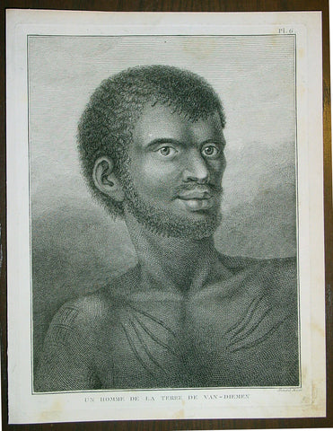
1785 Capt. Cook Antique Print Aboriginal Man of Bruny Island, Tasmania in 1777
- Title : Un Homme De La Terre De Van-Diemens
- Ref : 43195
- Size: 10in x 8in (255mm x 205mm)
- Date : 1785
- Condition: (A+) Fine Condition
Description:
This fine original copper-plate engraved antique print of an Indigenous Man of Adventure Bay, Bruny Island, Tasmania (Van Diemens Land) encountered by Captain Cook in during his 3rd & last Voyage of Discovery in 1777, was engraved by Robert Benard - after John Webber - and published in the 1785 French edition of Capt. James Cook & Capt. James King A Voyage to the Pacific Ocean. Undertaken, by the Command of his Majesty, for making Discoveries in the Northern Hemisphere. To determine The Position and Extent of the West Side of North America; its Distance from Asia; and the Practicability of a Northen Passage to Europe. Performed under the direction of Captains Cook, Clerke, and Gore, In His Majesty\'s Ships the Resolution and Discovery. In the Years 1776, 1777, 1778, 1779, and 1780. In Three Volumes. Vol. I and II written by James Cook, F.R.S. Vol. III by Captain James King, LL.D. and F.R.S. Paris, 1785.
Adventure Bay
from Cooks Journal......on the 24th (March 1777) at 3 AM we made the Coast of Van Diemen land wrote Cook. Anderson remarked that though now the middle of summer here a spot or two of snow was seen on the highest hills… At ten we passd a point supposd to be the boundary of Stone Bay where Abel Tasman anchord, i.e. Storm Bay. According to David Samwell, surgeons first mate on the Resolution, both Ships anchored in Adventure Bay in Van Diemens Land, this Bay was so called by Captn Furneaux who had anchored here in the Adventure last Voyage.
The next day Cook and Clerke sent parties, one to cut wood and the other grass. Clerke wrote of his party from the Discovery The Guard I had sent with the Parties on shore which consisted of the following Marines, Hamlet Thompson, Geo: Moody, Ben: Harriot, Jos: Pool & Willm Broom, stole some Liquor & made themselves exceedingly drunk, for which they receivd a dozen lashes each in the Morning. The Privates were all from the Plymouth division of marines. Hamlet Thompson was from the 6th Company, George Moody from the 70th, John Herriott the 12th, James Poole the 33rd and William Broom the 36th. According to Thomas Edgar, Master, they made themselves so Beastly Drunk that they were put motionless in the Boat, and when brought on board were oblig\'d to be hoisted into the Ship.
William Bayly, astronomer on the Discovery, wrote In the morning I carried my Tent observatory & Instruments on Shore & set all up, but was not able to get any observations it being cloudy all day, in the evening Capt Cook Sent for me & told me he had Altered his mind relative to his stay, & ordered me to pack all up & carry the whole on board again, as he intend[ed] to sail for New Zealand in a day or two.
John Henry Martin, seaman on the Discovery, described the natives. They have few, or no wants, & seemed perfectly Happy, if one might judge from their behaviour, for they frequently woud burst out, into the most immoderate fits of Laughter & when one Laughed every one followed his example Emediately.
General Definitions:
Paper thickness and quality: - Heavy and stable
Paper color : - off white
Age of map color: -
Colors used: -
General color appearance: -
Paper size: - 10in x 8in (255mm x 205mm)
Plate size: - 9 1/2in x 7 1/4in (240mm x 185mm)
Margins: - Min 1/2in (12mm)
Imperfections:
Margins: - None
Plate area: - None
Verso: - None
Background:
Adventure Bay is the name of both a township and a geographical feature on the eastern side of Bruny Island, Tasmania.
The first European to sight the bay was explorer Abel Tasman, who sought to anchor his vessel Heemskerck there in 1642. Instead, Heemskerck was driven back offshore by a storm, in token of which Tasman named the place Storm Bay. Captain Tobias Furneaux renamed it in March 1773, in honour of his ship HMS Adventure, which he had anchored in the bay for five days after becoming separated from Captain James Cook\'s HMS Resolution during Cook\'s second voyage to the Pacific search of Terra Australis Incognita. Furneaux\'s log made clear the bay was an excellent anchorage for resupplying vessels:....to the SW of the first watering place there is a large lagoon which I believe has plenty of fish in it for one of our Gentlemen caught upwards of 2 dozen trout, and shot a possum which was the only animal we saw. There are a great many gum trees and of a vast thickness and height, one of which measured in circumference 26 feet and the height under the branches was 20 feet.
Others among Furneaux\'s crew spotted evidence of what they believed were small deer but were more likely kangaroos. Furneaux also noted signs of an Aboriginal settlement in the form of several huts or wigwams on shore, with several bags of grass in which they carry their shellfish. - but the branches of which the huts were made were split and torn and there was not the least appearance of any people.
Reliably mapped and offering an abundance of water, fresh water and game, Adventure Bay quickly became a popular anchorage for European explorers. Cooks Resolution watered there in 1777, followed by William Bligh aboard HMS Bounty in 1788 and HMS Providence in 1792. Others who resupplied their vessels in the bay in this period included Bruni d Entrecasteaux aboard Recherché in 1792 and 1793, and Nicolas Baudin in the corvette Géographe in 1802. Matthew Flinders also tried to enter the bay with Norfolk in 1798.
John Hawkesworth 1715 – 1773 English writer and book editor.
He is said to have been clerk to an attorney, and was certainly self-educated. In 1744, he succeeded Samuel Johnson as compiler of the parliamentary debates for the Gentleman\\\'s Magazine, and from 1746 to 1749 he contributed poems signed Greville, or H Greville, to that journal. In company with Johnson and others he started a periodical called The Adventurer, which ran to 140 issues, of which 70 were from the pen of Hawkesworth himself.
On account of what was regarded as his powerful defense of morality and religion, Hawkesworth was rewarded by the archbishop of Canterbury with the degree of LL.D, In 1754–1755 he published an edition (12 vols) of Swifts works, with a life prefixed which Johnson praised in his Lives of the Poets. A larger edition (27 vols) appeared in 1766–1779. He adapted Dryden\\\'s Amphitryon for the Drury Lane stage in 1756, and Southernes Oronooko in 1759. He wrote the libretto of an oratorio Zimri in 1760, and the next year Edgar and Emmeline: a Fairy Tale was produced at Drury Lane. His Almoran and Hamet (1761) was first drafted as a play[citation needed], and a tragedy based on it by S J Pratt, The Fair Circassian (1781), met with some success.
He was commissioned by the Admiralty to edit Captain James Cooks papers relative to his first voyage. For this work, An Account of the Voyages undertaken ... for making discoveries in the Southern Hemisphere and performed by Commodore Byrone John Byron, Captain Wallis, Captain Carteret and Captain Cook (from 1702 to 1771) drawn up from the Journals ... (3 vols, 1773) Hawkesworth is said to have received from the publishers the sum of £6000. His descriptions of the manners and customs of the South Seas were, however, regarded by many critics as inexact and hurtful to the interests of morality, and the severity of their strictures is said to have hastened his death. He was buried in the parish church at Bromley, Kent, where he and his wife had kept a school.
Hawkesworth was a close imitator of Johnson both in style and thought, and was at one time on very friendly terms with him. It is said that he presumed on his success, and lost Johnsons friendship as early as 1756.
Captain James King FRS 1750 – 1784 was an officer of the Royal Navy. He served under James Cook on his last voyage around the world, specialising in taking important astronomical readings using a sextant. After Cook died he helped lead the ships on the remainder of their course, also completing Cook\\\'s account of the voyage. He continued his career in the Navy, reaching the rank of post-captain, commanding several ships and serving in the American War of Independence.
King joined HMS Resolution as second lieutenant, sharing the duties of astronomer with Cook, taking astronomical observations on board by sextant and with Larcum Kendals timekeeper K1, to establish the Resolutions position at sea and on shore by sextant or by astronomical quadrant to establish the geographical position of salient points during the course of Cooks surveys. Thus King\\\'s geographical positions were an important contribution to the accuracy of the various surveys carried out during the voyage and his use of the early chronometers helped prove their use at sea for calculation of Longitude. .
Following the death of Cook, King remained in the Resolution but on the death of Charles Clerke, Cooks successor, King was appointed to command HMS Discovery, the Resolution\\\'s consort, remaining in her for the rest of the voyage. After his return to England King was very much involved in the publication of the official account of Cooks third voyage, writing the third volume at Woodstock, near Oxford, where his brother Thomas was rector of St Mary Magdalene. But shortly after his return King was promoted Post-captain and appointed commander of HMS Crocodile in the English Channel.
John Webber RA 1751 – 1793 was an English artist who accompanied Captain Cook on his third Pacific expedition. He is best known for his images of Australasia, Hawaii and Alaska.
Webber was born in London, educated in Bern and studied painting at Paris.His father was Abraham Wäber, a Swiss sculptor who had moved to London, and changed his name to Webber before marrying a Mrs Mary Quant in 1744.
Webber served as official artist on James Cook\'s third voyage of discovery around the Pacific (1776–80) aboard HMS Resolution. At Adventure Bay in January 1777 he did drawings of A Man of Van Diemens Land and A Woman of Van Diemens Land. He also did many drawings of scenes in New Zealand and the South Sea islands. On this voyage, during which Cook lost his life in a fight in Hawaii, Webber became the first European artist to make contact with Hawaii, then called the Sandwich Islands. He made numerous watercolor landscapes of the islands of Kauai and Hawaii, and also portrayed many of the Hawaiian people.
In April 1778, Captain Cooks ships Resolution and Discovery anchored at Ship Cove, now known as Nootka Sound, Vancouver Island, Canada to refit. The crew took observations and recorded encounters with the local people. Webber made watercolour landscapes including Resolution and Discovery in Ship Cove, 1778. His drawings and paintings were engraved for British Admiraltys account of the expedition, which was published in 1784.
Back in England in 1780 Webber exhibited around 50 works at Royal Academy exhibitions between 1784 and 1792, and was elected an associate of the Royal Academy in 1785 and R.A. in 1791. Most of his work were landscapes. Sometimes figures were included as in A Party from H.M.S. Resolution shooting sea horses\", which was shown at the academy in 1784, and his The Death of Captain Cook became well known through an engraving of it. Another version of this picture is in the William Dixson gallery at Sydney
Robert Bénard 1734 – 1777 was an 18th-century French engraver.
Specialized in the technique of engraving, Robert Ménard is mainly famous for having supplied a significant amount of plates (at least 1,800) to the Encyclopédie by Diderot & d\'Alembert from 1751.
Later, publisher Charles-Joseph Panckoucke reused many of his productions to illustrate the works of his catalog.
1837 John Dower Original Antique Map of Australia - New Holland
- Title : Australia
- Date : 1837
- Size: 12in x 9 1/2in (305mm x 240mm)
- Ref #: 70704
- Condition: (B) Good Condition
Description:
This fine steel-plate engraved original hand coloured antique map of Australia by John Dower was published by Orr & Smith, London in 1837. (Ref Tooley M&B)
General Definitions:
Paper thickness and quality: - Heavy and stable
Paper color : - off white
Age of map color: - Original
Colors used: - Yellow
General color appearance: - Authentic
Paper size: - 12in x 9 1/2in (305mm x 240mm)
Plate size: - 12in x 9 1/2in (305mm x 240mm)
Margins: - Min 1/2in (12mm)
Imperfections:
Margins: - None
Plate area: - Browning & weak along centerfold
Verso: - Strengthened along centerold
Background:
Interesting early map of Australia with only the state of South Australia delineated. The whole of the east coast is named New South Wales, the city of Melbourne was not noted, few internal details are noted. Western Australia shows significant coastal details but is still named "New Holland"
1844 Hughes Antique Australian Map of the States of Victoria & NSW
- Title : Victoria New South Wales and South Australia
- Ref #: 91204
- Size: 17in x 11 1/4in (430mm x 285mm)
- Date : 1844
- Condition: (A+) Fine Condition
Description:
This finely engraved original antique map of the Australian States of NSW, Vic & part of SA was engraved by William Hughes and published by A&C Black in 1844. (Ref: Tooley; M&B)
General Description:
Paper thickness and quality: - Light and stable
Paper color: - off white
Age of map color: -
Colors used: -
General color appearance: -
Paper size: - 17in x 11 1/4in (430mm x 285mm)
Plate size: - 17in x 11 1/4in (430mm x 285mm)
Margins: - Min 1/2in (12mm)
Imperfections:
Margins: - None
Plate area: - None
Verso: - None
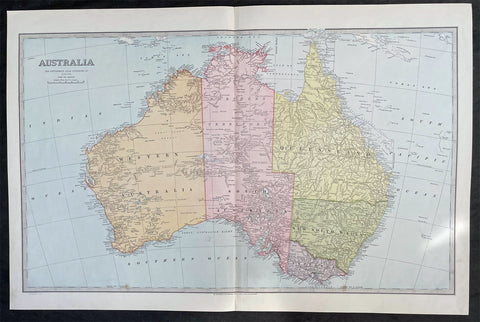
1888 Pic Atlas Scally Large Antique Map of Australia
- Title : Australia
- Date : 1888
- Condition: (A+) Fine Condition
- Ref: 31986
- Size: 25 1/2in x 17in (650mm x 430mm)
Description:
This large steel-plate engraved original antique lithograph map of Australia - engraved by Alex J Scally in 1888, dated at the foot of the map - was published in The Picturesque Atlas of Australasia, 1886-88. A beautiful large pre-federation antique map of Australia, highly detailed in fine condition.
General Description:
Paper thickness and quality: - Light & stable
Paper color: - White
Age of map color: - Original
Colors used: - Yellow, pink, green, blue
General color appearance: - Authentic
Paper size: - 25 1/2in x 17in (650mm x 430mm)
Margins: - Min 1in (25mm)
Imperfections:
Margins: - None
Plate area: - None
Verso: - None
1845 Handtke & Flemming Large Antique Map of Australia - Population of 213,500
- Title : Australland...1841
- Date : 1845
- Condition: (A+) Fine Condition
- Ref: 40972
- Size: 16in x 14in (405mm x 355mm)
Description:
This hand coloured original steel-plate engraved antique highly detailed map of Australia, with a population census of the entire country in 1841, by Friedrich Handtke in 1845, was published in the Complete hand atlas of the recent description of the earth over all parts of the earth, Carl Flemming, Glougau.
General Definitions:
Paper thickness and quality: - Heavy and stable
Paper color : - off white
Age of map color: - Original
Colors used: - Yellow, red
General color appearance: - Authentic
Paper size: - 16in x 14in (405mm x 355mm)
Plate size: - 16in x 14in (405mm x 355mm)
Margins: - Min 1/2in (12mm)
Imperfections:
Margins: - Light spotting
Plate area: - Light spotting
Verso: - Light spotting
Background:
Australia is a sovereign country comprising the mainland of the Australian continent, the island of Tasmania and numerous smaller islands. It is the largest country in Oceania and the world\'s sixth-largest country by total area. The neighbouring countries are Papua New Guinea, Indonesia and East Timor to the north; the Solomon Islands and Vanuatu to the north-east; and New Zealand to the south-east. The population of 25 million is highly urbanised and heavily concentrated on the eastern seaboard. Australias capital is Canberra, and its largest city is Sydney. The country\'s other major metropolitan areas are Melbourne, Brisbane, Perth and Adelaide.
Australia was inhabited by indigenous Australians for about 60,000 years before the first British settlement in the late 18th century. It is documented that Aborigines spoke languages that can be classified into about 250 groups. After the European discovery of the continent by Dutch explorers in 1606, who named it New Holland, Australia\'s eastern half was claimed by Great Britain in 1770 and initially settled through penal transportation to the colony of New South Wales from 26 January 1788, a date which became Australia\'s national day. The population grew steadily in subsequent decades, and by the 1850s most of the continent had been explored and an additional five self-governing crown colonies established. On 1 January 1901, the six colonies federated, forming the Commonwealth of Australia. Australia has since maintained a stable liberal democratic political system that functions as a federal parliamentary constitutional monarchy comprising six states and ten territories.
Being the oldest, flattest and driest inhabited continent, with the least fertile soils, Australia has a landmass of 7,617,930 square kilometres. A megadiverse country, its size gives it a wide variety of landscapes, with deserts in the centre, tropical rainforests in the north-east and mountain ranges in the south-east. A gold rush began in Australia in the early 1850s, which boosted the population of the country. Nevertheless, its population density, 2.8 inhabitants per square kilometre, remains among the lowest in the world. Australia generates its income from various sources including mining-related exports, telecommunications, banking and manufacturing. Indigenous Australian rock art is the oldest and richest in the world, dating as far back as 60,000 years and spread across hundreds of thousands of sites.
The first recorded European sighting of the Australian mainland, and the first recorded European landfall on the Australian continent (in 1606), are attributed to the Dutch. The first ship and crew to chart the Australian coast and meet with Aboriginal people was the Duyfken captained by Dutch navigator, Willem Janszoon. He sighted the coast of Cape York Peninsula in early 1606, and made landfall on 26 February at the Pennefather River near the modern town of Weipa on Cape York. The Dutch charted the whole of the western and northern coastlines and named the island continent New Holland during the 17th century, but made no attempt at settlement. William Dampier, an English explorer and privateer, landed on the north-west coast of New Holland in 1688 and again in 1699 on a return trip. In 1770, James Cook sailed along and mapped the east coast, which he named New South Wales and claimed for Great Britain.
With the loss of its American colonies in 1783, the British Government sent a fleet of ships, the First Fleet, under the command of Captain Arthur Phillip, to establish a new penal colony in New South Wales. A camp was set up and the flag raised at Sydney Cove, Port Jackson, on 26 January 1788, a date which became Australia\'s national day, Australia Day. A British settlement was established in Van Diemens Land, now known as Tasmania, in 1803, and it became a separate colony in 1825. The United Kingdom formally claimed the western part of Western Australia (the Swan River Colony) in 1828. Separate colonies were carved from parts of New South Wales: South Australia in 1836, Victoria in 1851, and Queensland in 1859. The Northern Territory was founded in 1911 when it was excised from South Australia. South Australia was founded as a free province—it was never a penal colony. Victoria and Western Australia were also founded free, but later accepted transported convicts. A campaign by the settlers of New South Wales led to the end of convict transportation to that colony; the last convict ship arrived in 1848.
1833 SDUK Antique Map of New South Wales w/ inset Map of Sydney Town, Australia
- Title : New South Wales...Sydney from the New South Wales Almanack...Sep 1833
- Size: 16in x 14in (410mm x 355m)
- Condition: (A) Very Good Condition
- Date : 1833
- Ref #: 32681
Description:
This fine original antique map of New South Wales, Australia - with an inset plan of Sydney Town - was engraved by J & C Walker, in 1833 - the date is engraved at the foot of the map - and was published in the Baldwin & Craddock edition of the Society For the Diffusion of Useful Knowledge (SDUK) Atlas.
General Definitions:
Paper thickness and quality: - Heavy and stable
Paper color : - off white
Age of map color: -
Colors used: -
General color appearance: -
Paper size: - 16in x 14in (410mm x 355m)
Plate size: - 16in x 14in (410mm x 355m)
Margins: - Min 1/4in (5mm)
Imperfections:
Margins: - Light age toning, left T&B corners cropped
Plate area: - Blind Library stamp
Verso: - Re-enforced on verso along margins
Background:
The SDUK produced two landmark volumes of cartography in the first half of the 19th century. The first volume concentrated on areas of the old world, Europe, Africa, Great Britain etc. The second volume contained maps of the new world, America, South Asia, including US state maps, colonies of Australia, South Africa, South America etc. Also included were some of the finest engraved town and city plans published at that time.
The SDUK was published in its entirety or in part by many publishers including Baldwin and Cradock 1829-32, Chapman & Hall in 1844, Charles Knight & co. 1846 – 1852. G. Cox published the SDUK between 1852-3, Stanford 1857-70 and later revised edition were also published after Stanford. (Ref: Tooley, M&B)
1833 SDUK Antique Map of Western Australia, Swan River Colony & Van Diemens Land
- Title : Western Australia containing the settlment of Swan River and King Georges Sound; Van-Diemens Land
- Size: 16in x 14in (410mm x 355m)
- Condition: (A) Very Good Condition
- Date : 1833
- Ref #: 32682
Description:
This original antique map of Western Australia - only 4 years after the first British settlement on the Swan river & Van Diemens Land or Tasmania was engraved by J & C Walker, in 1833 - the date is engraved at the foot of the map - and was published in the Baldwin & Craddock edition of the Society For the Diffusion of Useful Knowledge (SDUK) Atlas.
General Definitions:
Paper thickness and quality: - Heavy and stable
Paper color : - off white
Age of map color: -
Colors used: -
General color appearance: -
Paper size: - 16in x 14in (410mm x 355m)
Plate size: - 16in x 14in (410mm x 355m)
Margins: - Min 1/4in (5mm)
Imperfections:
Margins: - Light age toning
Plate area: - Blind Library stamp
Verso: - Re-enforced on verso along margins
Background:
The SDUK produced two landmark volumes of cartography in the first half of the 19th century. The first volume concentrated on areas of the old world, Europe, Africa, Great Britain etc. The second volume contained maps of the new world, America, South Asia, including US state maps, colonies of Australia, South Africa, South America etc. Also included were some of the finest engraved town and city plans published at that time.
The SDUK was published in its entirety or in part by many publishers including Baldwin and Cradock 1829-32, Chapman & Hall in 1844, Charles Knight & co. 1846 – 1852. G. Cox published the SDUK between 1852-3, Stanford 1857-70 and later revised edition were also published after Stanford. (Ref: Tooley, M&B)
1834 Henry Teesdale Antique Map The Pacific, Australia, New Zealand, Nth America
- Title : Chart of The Pacific Ocean.....London Published by Henry Teesdale & co. High Holborn March 1834
- Ref #: 50303
- Size: 17 1/2in x 14in (445mm x 355mm)
- Date : 1834
- Condition: (A+) Fine Condition
Description:
This beautifully hand coloured original copper-plate engraved antique map of the Pacific Ocean, Australia, New Zealand, to North & South America by John Dower was engraved in 1834 - the date is engraved at the foot of the map - and was published in the 1835 edition of Henry Teesdales A New General Atlas of the World. (Ref: M&B; Tooley)
General Definitions:
Paper thickness and quality: - Heavy and stable
Paper color : - off white
Age of map color: - Original
Colors used: - Yellow, green, blue, pink
General color appearance: - Authentic
Paper size: - 19in x 15 1/2in (485mm x 395mm)
Plate size: - 17 1/2in x 14 1/2in (445mm x 370mm)
Margins: - Min 1in (25mm)
Imperfections:
Margins: - None
Plate area: - None
Verso: - None
Teesdale & co., Henry fl 1828-1843
Teesdale was a prominent London publisher and founding fellow of the Royal Geographical Society. He produced large-scale maps and charts and a number of fine atlases in the early part of the nineteenth century. He employed the most skilled draftsmen and engravers and his maps are renowned for precise detail and fine coloring
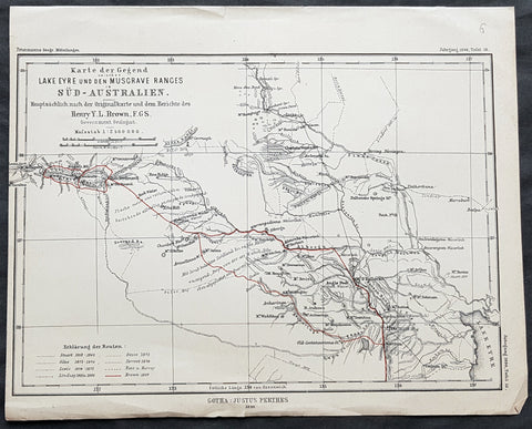
1890 Petermann Antique Map Lake Eyre to The Musgrave Ranges South Australia
- Title : Karte der Gegend zwischen Lake Eyre den Musgrave Ranges in Sud-Australien...Gotha: Justus Perthes 1890
- 10 1/2in x 8 1/2in (265mm x 215mm)
- Condition: (A+) Fine Condition
- Date : 1890
- Ref #: 82060
Description:
This original antique lithograph map of the area between Lake Eyre the Musgrave ranges in South Australia - with the tracks of 8 explorers of the region - by Augustus Heinrich Petermann was engraved in 1890 - dated - and was published by Justus Perthes, Gotha Germany.
General Definitions:
Paper thickness and quality: - Heavy and stable
Paper color : - off white
Age of map color: - Original
Colors used: - Red
General color appearance: - Authentic
Paper size: - 10 1/2in x 8 1/2in (265mm x 215mm)
Plate size: - 10 1/2in x 8 1/2in (265mm x 215mm)
Margins: - Min 1/2in (12mm)
Imperfections:
Margins: - None
Plate area: - Folds as issued
Verso: - None
Background:
The tracks of 8 different explorers are covered in this map. They are:
1. Sturat 1858-62
2. Giles 1873 - 1876
3. Lewis 1874 - 1875
4. Lindsay 1885 & 86
5. Gosse 1872
6. Forrest 1874
7. Ross & Harvey
8. Brown 1889
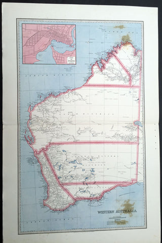
1888 Picturesque Atlas Large Antique Map of Western Australia
- Title : Map of New South Wales Showing Territorial Divisions, Land Board Districts and Land Districts
- Ref : 50337
- Size: 26in x 18in (660mm x 446mm)
- Date : 1886
- Condition: (A+) Fine Condition
Description:
This large fine lithograph layered coloured original map was published in the extremely significant Australian & New Zealand Australian & New Zealand publication The Picturesque Atlas of Australasia between 1886-88.
The Picturesque Atlas of Australasia was published in Sydney between 1886-88. Many of its over 700 wood-engraved illustrations were specially commissioned works by leading Australian artists. It was released in 42 separate editions usually bound into three large volumes and sold a remarkable 50,000 copies. (Ref: M&B; Tooley)
General Description:
Paper thickness and quality: - Light & stable
Paper color: - White
Age of map color: - Original
Colors used: - Blue, yellow, pink, green
General color appearance: - Authentic
Paper size: - 26in x 18in (660mm x 446mm)
Margins: - Min 1in (25mm)
Imperfections:
Margins: - None
Plate area: - None
Verso: - None
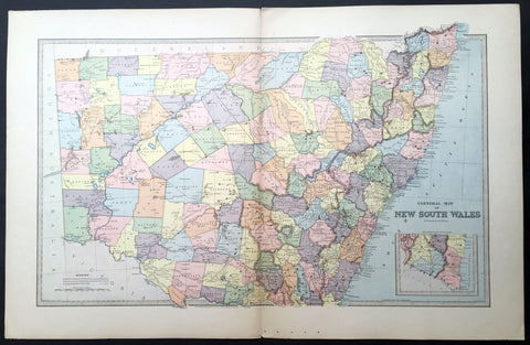
1888 Picturesque Atlas Large Antique Map of New South Wales, Australia
- Title : General Map of New South Wales
- Ref : 50339
- Size: 26in x 18in (660mm x 446mm)
- Date : 1886
- Condition: (A+) Fine Condition
Description:
This large fine lithograph layered coloured original map was published in the extremely significant Australian & New Zealand Australian & New Zealand publication The Picturesque Atlas of Australasia between 1886-88.
The Picturesque Atlas of Australasia was published in Sydney between 1886-88. Many of its over 700 wood-engraved illustrations were specially commissioned works by leading Australian artists. It was released in 42 separate editions usually bound into three large volumes and sold a remarkable 50,000 copies. (Ref: M&B; Tooley)
General Description:
Paper thickness and quality: - Light & stable
Paper color: - White
Age of map color: -
Colors used: -
General color appearance: -
Paper size: - 26in x 18in (660mm x 446mm)
Plate size: - 26in x 18in (660mm x 446mm)
Margins: - Min 1in (25mm)
Imperfections:
Margins: - None
Plate area: - None
Verso: - None
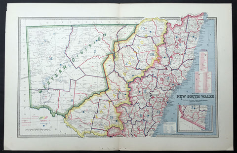
1888 Pic Atlas Large Antique Map of NSW, Australia Political & Local Borders
- Title : Map of New South Wales Showing Territorial Divisions, Land Board Districts and Land Districts
- Ref : 50337
- Size: 26in x 18in (660mm x 446mm)
- Date : 1886
- Condition: (A+) Fine Condition
Description:
This large fine lithograph layered coloured original map was published in the extremely significant Australian & New Zealand Australian & New Zealand publication The Picturesque Atlas of Australasia between 1886-88.
The Picturesque Atlas of Australasia was published in Sydney between 1886-88. Many of its over 700 wood-engraved illustrations were specially commissioned works by leading Australian artists. It was released in 42 separate editions usually bound into three large volumes and sold a remarkable 50,000 copies. (Ref: M&B; Tooley)
General Description:
Paper thickness and quality: - Light & stable
Paper color: - White
Age of map color: - Original
Colors used: - Blue, yellow, pink, green
General color appearance: - Authentic
Paper size: - 26in x 18in (660mm x 446mm)
Margins: - Min 1in (25mm)
Imperfections:
Margins: - None
Plate area: - None
Verso: - None
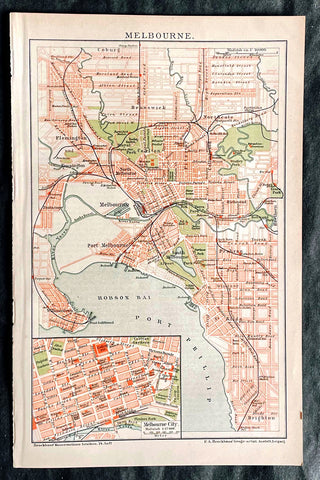
1896 F.A. Brockhaus Antique Map, Street Plan of Melbourne, Victoria, Australia
Antique Map
- Title : Melbourne
- Ref #: 27012
-
Condition: (A+) Fine Condition
- Size: 10in x 6 1/2in (255mm x 165mm)
- Date : 1896
Description:
This original antique lithograph street map of Melbourne Australia was engraved and published F.A. Brockhaus for the Brockhaus Konversations Lexikon, Germany, 1896
General Definitions:
Paper thickness and quality: - Heavy and stable
Paper color : - off white
Age of map color: - Original
Colors used: - Yellow, green, blue, pink
General color appearance: - Authentic
Paper size: - 10in x 6 1/2in (255mm x 165mm)
Plate size: - 10in x 6 1/2in (255mm x 165mm)
Margins: - Min 1/2in (12mm)
Imperfections:
Margins: - None
Plate area: - None
Verso: - None
Brockhaus, Friedrich Arnold (1772 - 1823)
Friedrich Arnold Brockhaus was a German encyclopedia publisher and editor, famed for publishing the Conversations-Lexikon, which is now published as the Brockhaus encyclopedia.
Brockhaus was educated at the gymnasium of his native Dortmund, and from 1788 to 1793 served an apprenticeship in a mercantile house at Düsseldorf. He then devoted two years at the University of Leipzig to the study of modern languages and literature, after which he set up in Dortmund an emporium for English goods. In 1801, he transferred this business to Arnheim, and in the following year to Amsterdam.
In 1805, having given up his first line of trade, Brockhaus began business as a publisher. Two journals projected by him were not allowed by the government to survive for any length of time, and in 1810 the complications in the affairs of Holland induced him to return homewards. In 1811 he settled at Altenburg. About three years previously he had purchased the copyright of the bankrupt Conversations-Lexikon, an encyclopedia started in 1796, and in 1810-1811 he completed the first edition of this celebrated work. It was widely imitated as a model for encyclopedias, and is still published today, known as the Brockhaus Encyclopedia.
A second edition under Brockhauss editorship was begun in 1812, and was received with universal favour. His business extended rapidly, and in 1818 Brockhaus moved to Leipzig, where he established a large printing-house. Among the more extensive of his many literary undertakings were the critical periodicals — Hermes, the Literarisches Konversationsblatt (afterwards the Blätter für literarische Unterhaltung) and the Zeilgenossen, and some large historical and bibliographical works, such as Friedrich Ludwig Georg von Raumers Geschichte der Hohenstaufen, and Friedrich Adolf Eberts Allgemeines bibliographisches Lexikon.
Brockhaus died in Leipzig. The business was carried on by his sons, Friedrich Brockhaus (1800–1865), who retired in 1850, and Heinrich Brockhaus (1804–1874), under whom it was considerably extended. Heinrich especially rendered great services to literature and science, which the University of Jena recognized by making him, in 1858, honorary Doctor of Philosophy. In the years 1842–1848, Heinrich Brockhaus was member of the Saxon second chamber, as representative for Leipzig, was made honorary citizen of that city in 1872, and died there on 15 November 1874.
His firm continues under the name F.A. Brockhaus AG in his honor. He is also the namesake of 27765 Brockhaus, a main-belt asteroid discovered in 1991.
Please note all items auctioned are genuine, we do not sell reproductions. A Certificate of Authenticity (COA) can be issued on request.
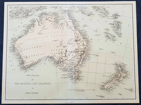
1856 James Virtue Antique Map of New Zealand and the Colonies of Australia
- Title : New Zealand and the Australian Colonies of Great Britain James S Virtue
- Size: 13in x 10in (330mm x 255mm)
- Condition: (A+) Fine Condition
- Date : 1856
- Ref #: 93052
Description:
This original lithograph antique map of New Zealand and the Colonies of Australia was published by James Virtue in 1856, just after Victorian statehood in 1851 and just prior to Queensland statehood in 1859.
General Definitions:
Paper thickness and quality: - Heavy and stable
Paper color : - off white
Age of map color: - Original
Colors used: - Pink, blue
General color appearance: - Authentic
Paper size: - 13in x 10in (330mm x 255mm)
Plate size: - 13in x 10in (330mm x 255mm)
Margins: - Min 1/2in (12mm)
Imperfections:
Margins: - None
Plate area: - None
Verso: - None
Background:
A highly detailed map just prior to the gold and population boom of both Australia and New Zealand, with much of Australia unexplored in the center.
Virtue, George & James
George Virtue (1794 – 1868) was a 19th-century London publisher, well known for printing engravings. His publishing house was located at 26 Ivy Lane, Paternoster Row, London, EC
Virtue selected accomplished artists, employed the best engravers, and produced books that were rarely surpassed in elegance and correctness for the period. Chief among his publications were the following, all illustrated by William Henry Bartlett: Switzerland, by William Beattie, 2 vols. 1836; Scotland, by W. Beattie, 1838; The Waldenses, by W. Beattie, 1838; American Scenery, 2 vols. 1840; Description of the Beauties of the Bosphorus, by Julia Pardoe, 1840; and The Danube, its History and Scenery, by W. Beattie, 1844. Virtue created a prodigious business, issuing upwards of twenty thousand copper and steel engravings through his career.
In 1848, Virtue purchased two magazines. One was an art publication, The Art Union, which had been founded in 1839 by Hodgson & Graves, then purchased in 1847 by Chapman & Hall. The second purchase was controlling interest in Sharpe\\\\\\\'s London Magazine, a literary and cultural magazine, Arthur Hall publisher. In 1849, Virtue renamed the art magazine The Art Journal and, in time, it became known as the premier art publication of Great Britain. Also in 1849, he created a new firm with Arthur Hall called Arthur Hall, Virtue & Co
James Sprent Virtue (1829 – 1892) inherited the publishing business from his father, George, after his retirement in 1855
Please note all items auctioned are genuine, we do not sell reproductions. A Certificate of Authenticity (COA) can be issued on request.
1835 Joseph Meyer Antique Print Early View of The Rocks Sydney, Australia
- Title : Sydney in New South Wales
- Ref #: 50668
- Size: 10in x 7 1/2in (255mm x 190mm)
- Date : 1835
- Condition: (A+) Fine Condition
Description:
This fine steel-plate engraved original antique print an early view of The Rocks in Sydney Australia by Joseph Meyer was published in the 1835 edition of Meyers Universum
These are beautiful steel-plate engraved prints, with a high level of detail along with beautifully executed artistry.
General Definitions:
Paper thickness and quality: - Heavy and stable
Paper color : - off white
Age of map color: -
Colors used: -
General color appearance: -
Paper size: - 10in x 7 1/2in (255mm x 190mm)
Plate size: - 10in x 7 1/2in (255mm x 190mm)
Margins: - Min 1/2in (12mm)
Imperfections:
Margins: - None
Plate area: - None
Verso: - None
Background:
The History of Sydney begins in prehistoric times with the occupation of the district by Australian Aborigines, whose ancestors came to Sydney in the Upper Paleolithic period. The modern history of the city began with the arrival of a First Fleet of British ships in 1788 and the foundation of a penal colony by Great Britain.
From 1788 to 1900 Sydney was the capital of the British colony of New South Wales. An elected city council was established in 1840. In 1900, Sydney became a state capital, when New South Wales voted to join the Australian Federation. Sydney today is Australia\'s largest city and a major international capital of culture and finance. The city has played host to many international events, including the 2000 Summer Olympics.
Meyer, Joseph 1796 - 1856
Meyer was a German industrialist and publisher, most noted for his encyclopedia, Meyers Konversations-Lexikon.
Meyer was born at Gotha, Germany, and was educated as a merchant in Frankfurt am Main. He went to London in 1816, but returned to Germany in 1820 after business adventures and stock speculations fell through. Here he invested in enterprises like textile-trade (1820–24). Soon after the first steam-hauled railway had started in December 1835, Meyer started to make business plans how to start the first railways. He also bought some concessions for iron mining. In 1845, he founded the Deutsche Eisenbahnschienen-Compagnie auf Actien (German Railway Rail joint stock company).
Meyer operated very successfully as a publisher, employing a system of serial subscription to publications, which was new at that time. To this end he founded a company, Bibliographisches Institut, in Gotha in 1826. It published several editions of the Bible, works of classical literature (Miniatur-Bibliothek der deutschen Classiker, Groschen-Bibliothek), atlases, the world in pictures on steel engravings Meyers Universum, 1833–61, 17 volumes in 12 languages with 80,000 subscribers all over Europe), and an encyclopaedia, (das Grosse Conversations-Lexikon für die gebildeten Stände;). His company grew substantially, and in 1828 he moved it from Gotha to Hildburghausen, where he died thirty years later.
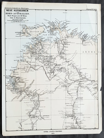
1878 Petermann Antique Map of Northern Territory Australia - William McMinn 1876
- Title : Neue Aufnahmen in Nord-Australien Nach. Ringwood & Mc Minn...Gotha: Justus Perthes 1878
- 10 1/2in x 8 1/2in (265mm x 215mm)
- Condition: (A+) Fine Condition
- Date : 1878
- Ref #: 82058
Description:
This scarce original antique lithograph map of north-west Northern Territory, Australia showing Palmerston at Port Darwin, place names and exploration routes, including that of William McMinn in 1876, by Augustus Heinrich Petermann was engraved in 1878 - dated - and was published by Justus Perthes, Gotha Germany.
General Definitions:
Paper thickness and quality: - Heavy and stable
Paper color : - off white
Age of map color: - Original
Colors used: - Yellow, blue
General color appearance: - Authentic
Paper size: - 10 1/2in x 8 1/2in (265mm x 215mm)
Plate size: - 10 1/2in x 8 1/2in (265mm x 215mm)
Margins: - Min 1/2in (12mm)
Imperfections:
Margins: - None
Plate area: - None
Verso: - None
Background:
William McMinn (1844 – 14 February 1884) was an Australian surveyor and architect, based in Adelaide.
He was born in Newry, County Down, Ireland, a son of Joseph McMinn and his wife Martha McMinn (née Hamill), who with their large family emigrated to Adelaide on the Albatross, arriving in September 1850.
After completing school, he was apprenticed to the architect James Macgeorge, but first practiced as a surveyor. He was involved in Boyle Travers Finniss\'s ill-fated 1865 expedition to Northern Australia surveying the area around the Adelaide River. Following the desertion of a majority of the party to Singapore, McMinn and 5 others purchased a 23-foot open boat which they named the Forlorn Hope and sailed it 2,000 miles (3,200 km) to Champion Bay, Geraldton, Western Australia. He was later involved in the 1872 surveying of the Overland Telegraph from Port Augusta to Darwin.
McMinn began practising as an architect in 1867, briefly in partnership with Daniel Garlick, and later with some others, but usually independently. He designed many grand private residences, but also designed or assisted in the design of many of Adelaide\'s grand public buildings. Whilst in partnership with Edward John Woods, he designed the original Venetian Gothic building of the University of Adelaide, considered his greatest work.
1886 Picturesque Atlas Large Antique Rainfall Map of New South Wales, Australia
- Title : Map of New South Wales showing Average Annual Rainfall
- Ref : 50340
- Size: 26in x 18in (660mm x 446mm)
- Date : 1886
- Condition: (A+) Fine Condition
Description:
This large fine lithograph layered coloured original map was published in the extremely significant Australian & New Zealand Australian & New Zealand publication The Picturesque Atlas of Australasia between 1886-88.
The Picturesque Atlas of Australasia was published in Sydney between 1886-88. Many of its over 700 wood-engraved illustrations were specially commissioned works by leading Australian artists. It was released in 42 separate editions usually bound into three large volumes and sold a remarkable 50,000 copies. (Ref: M&B; Tooley)
General Description:
Paper thickness and quality: - Light & stable
Paper color: - White
Age of map color: - Original
Colors used: - Blue, yellow, pink, green
General color appearance: - Authentic
Paper size: - 26in x 18in (660mm x 446mm)
Margins: - Min 1in (25mm)
Imperfections:
Margins: - None
Plate area: - None
Verso: - None
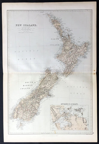
1870 Blackie & Son Large Antique Map of New Zealand w/ inset plan of Auckland
- Title : New Zealand
- Ref: 80571
- Size: 22in x 15in (560mm x 380mm)
- Date : 1870
- Condition: (A+) Fine Condition
Description:
This fine large, original antique map of New Zealand with an inset map of Auckland and its environs by John Bartholomew was published by Blackie & Son of Glasgow & London in the 1870 edition of the Geographical Atlas. (Ref: Tooley; M&B)
General Description:
Paper thickness and quality: - Heavy and stable
Paper colour: - off white
Age of map colour: - Original
Colours used: - Yellow, pink, green
General colour appearance: - Authentic
Paper size: - 22in x 15in (560mm x 380mm)
Margins: - min 1/2in (12mm)
Imperfections:
Margins: - None
Plate area: - None
Verso: - None
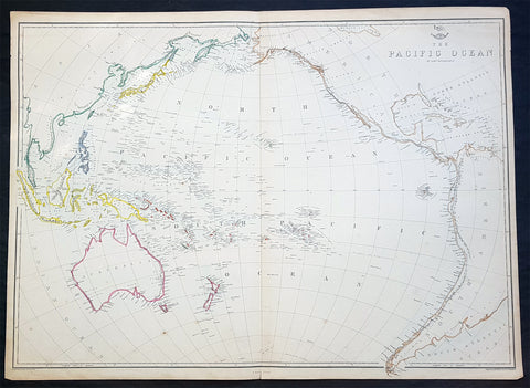
1860 Edward Weller Large Antique Map of The Pacific - Australia to California
Antique Map
- Title : The Pacific Ocean
- Ref #: 70063
- Size: 26 1/2in x 19in (675mm x 490mm)
- Date : 1860
- Condition: (A+) Fine Condition
Description:
This original steel plate engraved hand coloured antique map by Edward Weller was published in the 1860 edition of The Dispatch Atlas; a compilation of maps Weller had already published in The Weekly Dispatch.
General Definitions:
Paper thickness and quality: - Heavy and stable
Paper color : - off white
Age of map color: - Original
Colors used: - Yellow, Green, pink
General color appearance: - Authentic
Paper size: - 26 1/2in x 19in (675mm x 490mm)
Plate size: - 26 1/2in x 19in (675mm x 490mm)
Margins: - Min 1/2in (10mm)
Imperfections:
Margins: - None
Plate area: - None
Verso: - None
Weller, Edward 1819 – 1884
Weller was a London-based engraver, cartographer and publisher, working from offices in Red Lion Square and later, Bloomsbury. Amongst his considerable portfolio were various atlases, many of which focussed on the educational publishing market. Having established his credentials as an engraver of finely detailed works, he sold maps to be published in a number of regular magazines and pamphlets, perhaps the best known being The Dispatch Atlas; a compilation of maps Weller had already published in The Weekly Dispatch. Although Weller usually engraved the maps himself, he did work in partnership with others, particularly John Dower for this 1858 and 1863 volume. Weller also published The Crown Atlas in 1871.
The Dispatch Atlas featured well over one hundred superbly detailed steel plate engraved maps, usually with simplistic, single colour outline hand colouring, and a distinctive header style. Most English counties featured, some of which were divided onto separate sheets, affording space to engrave in even greater detail. The maps of North and South Devonshire for example include such details as individual property names, as do those of the Northern and Southern parts of Hampshire.
After Wellers death in 1884, many of these astonishingly detailed plates were sold on to other map makers, including George Washington Bacon, who, whilst retaining the level of detail, expanded the printing area of each plate, adding more precise and varied hand colouring in keeping with the final decades of the century.
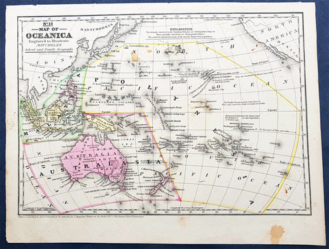
1839 Samuel Augustus Mitchell Antique Map of New Holland, New Zealand & Oceania
- Title : No 18 Map of Oceania...Entered according to Act of Congress in the year 1839 by S Augustus Mitchell
- Date : 1839
- Condition: (A) Very Good Condition
- Ref: 32148
- Size: 12in x 9in (305mm x 230mm)
Description:
This detailed original hand coloured copper-plate engraved antique map of New Holland - Australia, New Zealand, Polynesia & Micronesia, Oceania by Samuel Augustus Mitchell in 1839 - dated - was published in Mitchells School and Family Geography
General Definitions:
Paper thickness and quality: - Heavy and stable
Paper color : - off white
Age of map color: - Original
Colors used: - Yellow, green, blue, pink
General color appearance: - Authentic
Paper size: - 12in x 9in (305mm x 230mm)
Plate size: - 12in x 9in (305mm x 230mm)
Margins: - Min 1/2in (12mm)
Imperfections:
Margins: - Light soiling
Plate area: - Light soiling
Verso: - Light soiling
Background:
Early map of Australia and Oceania, the east coast is still referred to as NSW, with no sign of development of Melbourne or Victoria with New Zealand listing early Cook & Maori place names.
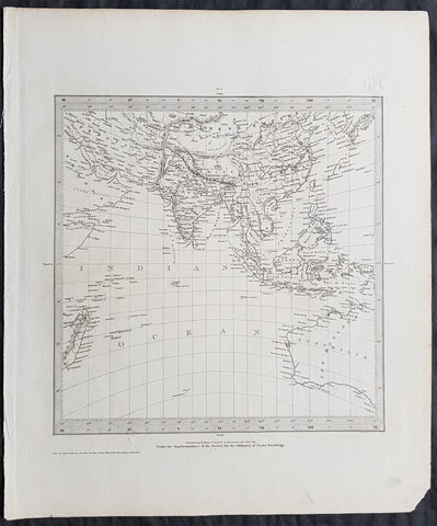
1831 SDUK Antique Gnomonic Map of Western Australia & The Indian Ocean, SE Asia
- Title : Published by Baldwin & Craddock...June 1831
- Size: 16in x 14in (410mm x 355m)
- Condition: (A+) Fine Condition
- Date : 1831
- Ref #: 32534
Description:
This original steel-plate engraved antique Gnomonic Map of Western Australia & The Indian Ocean was engraved by J & C Walker, in 1831 - dated at the foot of the map - and was published in the Baldwin & Craddock edition of the Society For the Diffusion of Useful Knowledge (SDUK) Atlas.
A gnomonic map projection displays all great circles as straight lines, resulting in any line segment on a gnomonic map showing a geodesic, the shortest route between the segment\'s two endpoints. This is achieved by casting surface points of the sphere onto a tangent plane, each landing where a ray from the center of the sphere passes through the point on the surface and then on to the plane. No distortion occurs at the tangent point, but distortion increases rapidly away from it. Less than half of the sphere can be projected onto a finite map. Consequently a rectilinear photographic lens cannot image more than 180 degrees.
General Definitions:
Paper thickness and quality: - Heavy and stable
Paper color : - off white
Age of map color: -
Colors used: -
General color appearance: -
Paper size: - 16in x 14in (410mm x 355m)
Plate size: - 16in x 14in (410mm x 355m)
Margins: - Min 1/4in (5mm)
Imperfections:
Margins: - None
Plate area: - Blind Library stamp
Verso: - None
Background:
The SDUK produced two landmark volumes of cartography in the first half of the 19th century. The first volume concentrated on areas of the old world, Europe, Africa, Great Britain etc. The second volume contained maps of the new world, America, South Asia, including US state maps, colonies of Australia, South Africa, South America etc. Also included were some of the finest engraved town and city plans published at that time.
The SDUK was published in its entirety or in part by many publishers including Baldwin and Cradock 1829-32, Chapman & Hall in 1844, Charles Knight & co. 1846 – 1852. G. Cox published the SDUK between 1852-3, Stanford 1857-70 and later revised edition were also published after Stanford. (Ref: Tooley, M&B)
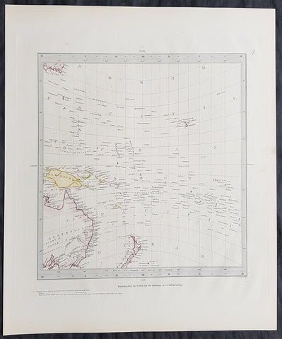
1840 SDUK Antique Gnomonic Map East Australia, New Zealand South Pacific
- Title : Published by the Society for the Diffusion of Useful Knowledge
- Size: 16in x 14in (410mm x 355m)
- Condition: (A+) Fine Condition
- Date : 1840
- Ref #: 11-0974
Description:
This hand coloured original steel-plate engraved antique Gnomonic Map of eastern Australia, New Zealand & The South Pacific was engraved by J & C Walker, in 1840 and was published in the Chapman & Hall edition of the Society For the Diffusion of Useful Knowledge (SDUK) Atlas.
A gnomonic map projection displays all great circles as straight lines, resulting in any line segment on a gnomonic map showing a geodesic, the shortest route between the segment\'s two endpoints. This is achieved by casting surface points of the sphere onto a tangent plane, each landing where a ray from the center of the sphere passes through the point on the surface and then on to the plane. No distortion occurs at the tangent point, but distortion increases rapidly away from it. Less than half of the sphere can be projected onto a finite map. Consequently a rectilinear photographic lens cannot image more than 180 degrees.
General Definitions:
Paper thickness and quality: - Heavy and stable
Paper color : - off white
Age of map color: - Original
Colors used: - Yellow, pink, green, blue
General color appearance: - Authentic
Paper size: - 16in x 14in (410mm x 355m)
Plate size: - 16in x 14in (410mm x 355m)
Margins: - Min 1/4in (5mm)
Imperfections:
Margins: - Light age toning
Plate area: - None
Verso: - None
Background:
The SDUK produced two landmark volumes of cartography in the first half of the 19th century. The first volume concentrated on areas of the old world, Europe, Africa, Great Britain etc. The second volume contained maps of the new world, America, South Asia, including US state maps, colonies of Australia, South Africa, South America etc. Also included were some of the finest engraved town and city plans published at that time.
The SDUK was published in its entirety or in part by many publishers including Baldwin and Cradock 1829-32, Chapman & Hall in 1844, Charles Knight & co. 1846 – 1852. G. Cox published the SDUK between 1852-3, Stanford 1857-70 and later revised edition were also published after Stanford. (Ref: Tooley, M&B)
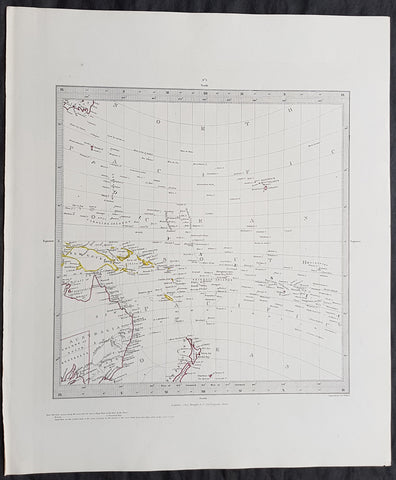
Copy of 1840 SDUK Antique Gnomonic Map East Australia, New Zealand South Pacific
- Title : Published by the Society for the Diffusion of Useful Knowledge
- Size: 16in x 14in (410mm x 355m)
- Condition: (A+) Fine Condition
- Date : 1840
- Ref #: 11-0984
Description:
This hand coloured original steel-plate engraved antique Gnomonic Map of eastern Australia, New Zealand & The South Pacific was engraved by J & C Walker, in 1840 and was published in the Chapman & Hall edition of the Society For the Diffusion of Useful Knowledge (SDUK) Atlas.
A gnomonic map projection displays all great circles as straight lines, resulting in any line segment on a gnomonic map showing a geodesic, the shortest route between the segment\'s two endpoints. This is achieved by casting surface points of the sphere onto a tangent plane, each landing where a ray from the center of the sphere passes through the point on the surface and then on to the plane. No distortion occurs at the tangent point, but distortion increases rapidly away from it. Less than half of the sphere can be projected onto a finite map. Consequently a rectilinear photographic lens cannot image more than 180 degrees.
General Definitions:
Paper thickness and quality: - Heavy and stable
Paper color : - off white
Age of map color: - Original
Colors used: - Yellow, pink, green, blue
General color appearance: - Authentic
Paper size: - 16in x 14in (410mm x 355m)
Plate size: - 16in x 14in (410mm x 355m)
Margins: - Min 1/4in (5mm)
Imperfections:
Margins: - Light age toning
Plate area: - None
Verso: - None
Background:
The SDUK produced two landmark volumes of cartography in the first half of the 19th century. The first volume concentrated on areas of the old world, Europe, Africa, Great Britain etc. The second volume contained maps of the new world, America, South Asia, including US state maps, colonies of Australia, South Africa, South America etc. Also included were some of the finest engraved town and city plans published at that time.
The SDUK was published in its entirety or in part by many publishers including Baldwin and Cradock 1829-32, Chapman & Hall in 1844, Charles Knight & co. 1846 – 1852. G. Cox published the SDUK between 1852-3, Stanford 1857-70 and later revised edition were also published after Stanford. (Ref: Tooley, M&B)
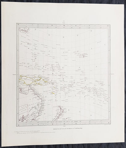
1840 SDUK Antique Gnomonic Map East Australia, New Zealand South Pacific
- Title : Published by the Society for the Diffusion of Useful Knowledge
- Size: 16in x 14in (410mm x 355m)
- Condition: (A+) Fine Condition
- Date : 1840
- Ref #: 24676-1
Description:
This hand coloured original steel-plate engraved antique Gnomonic Map of eastern Australia, New Zealand & The South Pacific was engraved by J & C Walker, in 1840 and was published in the Chapman & Hall edition of the Society For the Diffusion of Useful Knowledge (SDUK) Atlas.
A gnomonic map projection displays all great circles as straight lines, resulting in any line segment on a gnomonic map showing a geodesic, the shortest route between the segment\'s two endpoints. This is achieved by casting surface points of the sphere onto a tangent plane, each landing where a ray from the center of the sphere passes through the point on the surface and then on to the plane. No distortion occurs at the tangent point, but distortion increases rapidly away from it. Less than half of the sphere can be projected onto a finite map. Consequently a rectilinear photographic lens cannot image more than 180 degrees.
General Definitions:
Paper thickness and quality: - Heavy and stable
Paper color : - off white
Age of map color: - Original
Colors used: - Yellow, pink, green, blue
General color appearance: - Authentic
Paper size: - 16in x 14in (410mm x 355m)
Plate size: - 16in x 14in (410mm x 355m)
Margins: - Min 1/4in (5mm)
Imperfections:
Margins: - Light age toning
Plate area: - None
Verso: - None
Background:
The SDUK produced two landmark volumes of cartography in the first half of the 19th century. The first volume concentrated on areas of the old world, Europe, Africa, Great Britain etc. The second volume contained maps of the new world, America, South Asia, including US state maps, colonies of Australia, South Africa, South America etc. Also included were some of the finest engraved town and city plans published at that time.
The SDUK was published in its entirety or in part by many publishers including Baldwin and Cradock 1829-32, Chapman & Hall in 1844, Charles Knight & co. 1846 – 1852. G. Cox published the SDUK between 1852-3, Stanford 1857-70 and later revised edition were also published after Stanford. (Ref: Tooley, M&B)
1840 P & A Lapie Antique Map of New Holland, New Zealand & Central Coast of NSW
- Title : Oceania
- Date : 1840
- Condition: (A+) Fine Condition
- Ref: 21425
- Size: 17in x 12in (430mm x 305mm)
Description:
This detailed original hand coloured lithograph map of Australia, New Zealand, Polynesia & Micronesia - Oceania - with an inset map of part of the coast of Sydney, NSW from Double Bay to Shoal Bay by Pierre & Alexandrie Lapie was published as a single map Kaeppelin & Co. in 1840.
General Definitions:
Paper thickness and quality: - Heavy and stable
Paper color : - off white
Age of map color: - Original
Colors used: - Yellow, green, blue, pink
General color appearance: - Authentic
Paper size: - 17in x 12in (430mm x 305mm)
Plate size: - 17in x 12in (430mm x 305mm)
Margins: - Min 1/2in (12mm)
Imperfections:
Margins: - None
Plate area: - None
Verso: - None
Background:
Early map of Australia and Oceania, the east coast is still referred to as NSW, with no sign of development of Melbourne or Victoria with New Zealand listing early Cook & Maori place names. The inset map of the central NSW coast is still largely lacking in detail past Bathurst, with Australia Felix noted in the south.
Lapie, Pierre & Alexandre
Pierre M. Lapie 1779 - 1850 and his son Alexandre Emile Lapie 1809 - 1850 were French cartographers and engravers active in the early part of the 19th century. The Lapies were commissioned officers in the French army holding the ranks of Colonel and Captain, respectively. Alexander enjoyed the title of First Geographer to the King, and this title appears on several of his atlases. Both father and son were exceptional engravers and fastidious cartographers. Working separately and jointly they published four important atlases, an 1811 Atlas of the French Empire (Alexander), the 1812 Atlas Classique et Universel (Pierre), the Atlas Universel de Geographie Ancienne et Modern (joint issue), and the 1848 Atlas Militaire (Alexander). They also issued many smaller maps and independent issues. All of these are products of exceptional beauty and detail. Despite producing many beautiful maps and atlases, the work of the Lapie family remains largely underappreciated by most modern collectors and map historians. The later 19th century cartographer A. H. Dufour claimed to be a student of Lapie, though it is unclear if he was referring to the father or the son. The work of the Lapie firm, with its precise engraving and informational density, strongly influenced the mid-19th century German commercial map publishers whose maps would eventually dominate the continental market.
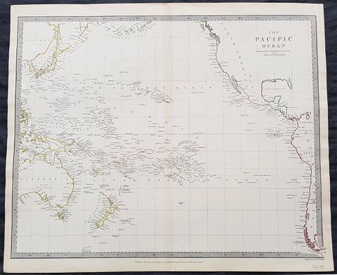
1840 SDUK Antique Map of The Pacific Ocean, North America, Japan, Australia, New Zealand
- Title : The Pacific Ocean.....Published by Chapman & Hall...May 15th 1840
- Size: 16in x 14in (410mm x 355m)
- Condition: (A+) Fine Condition
- Date : 1840
- Ref #: 31980
Description:
This hand coloured original steel-plate engraved antique map of The Pacific Ocean from North America, Japan, Australia & New Zealand was engraved by J & C Walker, in 1840 - the date is engraved at the foot of the map - and was published in the Chapman & Hall edition of the Society For the Diffusion of Useful Knowledge (SDUK) Atlas.
General Definitions:
Paper thickness and quality: - Heavy and stable
Paper color : - off white
Age of map color: - Original
Colors used: - Yellow, pink, green, blue
General color appearance: - Authentic
Paper size: - 16in x 14in (410mm x 355m)
Plate size: - 16in x 14in (410mm x 355m)
Margins: - Min 1/4in (5mm)
Imperfections:
Margins: - Light age toning
Plate area: - None
Verso: - None
Background:
The SDUK produced two landmark volumes of cartography in the first half of the 19th century. The first volume concentrated on areas of the old world, Europe, Africa, Great Britain etc. The second volume contained maps of the new world, America, South Asia, including US state maps, colonies of Australia, South Africa, South America etc. Also included were some of the finest engraved town and city plans published at that time.
The SDUK was published in its entirety or in part by many publishers including Baldwin and Cradock 1829-32, Chapman & Hall in 1844, Charles Knight & co. 1846 – 1852. G. Cox published the SDUK between 1852-3, Stanford 1857-70 and later revised edition were also published after Stanford. (Ref: Tooley, M&B)
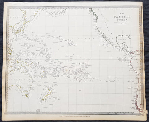
1840 SDUK Antique Map of The Pacific Ocean, North America, Japan, Australia, New Zealand
- Title : The Pacific Ocean.....Published by Chapman & Hall...May 15th 1840
- Size: 16in x 14in (410mm x 355m)
- Condition: (A+) Fine Condition
- Date : 1840
- Ref #: 91362
Description:
This hand coloured original steel-plate engraved antique map of The Pacific Ocean from North America, Japan, Australia & New Zealand was engraved by J & C Walker, in 1840 - the date is engraved at the foot of the map - and was published in the Chapman & Hall edition of the Society For the Diffusion of Useful Knowledge (SDUK) Atlas.
General Definitions:
Paper thickness and quality: - Heavy and stable
Paper color : - off white
Age of map color: - Original
Colors used: - Yellow, pink, green, blue
General color appearance: - Authentic
Paper size: - 16in x 14in (410mm x 355m)
Plate size: - 16in x 14in (410mm x 355m)
Margins: - Min 1/4in (5mm)
Imperfections:
Margins: - Light age toning
Plate area: - None
Verso: - None
Background:
The SDUK produced two landmark volumes of cartography in the first half of the 19th century. The first volume concentrated on areas of the old world, Europe, Africa, Great Britain etc. The second volume contained maps of the new world, America, South Asia, including US state maps, colonies of Australia, South Africa, South America etc. Also included were some of the finest engraved town and city plans published at that time.
The SDUK was published in its entirety or in part by many publishers including Baldwin and Cradock 1829-32, Chapman & Hall in 1844, Charles Knight & co. 1846 – 1852. G. Cox published the SDUK between 1852-3, Stanford 1857-70 and later revised edition were also published after Stanford. (Ref: Tooley, M&B)
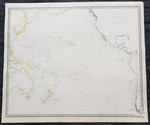
1840 SDUK Antique Map of The Pacific Ocean, North America, Japan, Australia, New Zealand
- Title : The Pacific Ocean.....Published by Chapman & Hall...May 15th 1840
- Size: 16in x 14in (410mm x 355m)
- Condition: (A+) Fine Condition
- Date : 1840
- Ref #: 11-0964
Description:
This hand coloured original steel-plate engraved antique map of The Pacific Ocean from North America, Japan, Australia & New Zealand was engraved by J & C Walker, in 1840 - the date is engraved at the foot of the map - and was published in the Chapman & Hall edition of the Society For the Diffusion of Useful Knowledge (SDUK) Atlas.
General Definitions:
Paper thickness and quality: - Heavy and stable
Paper color : - off white
Age of map color: - Original
Colors used: - Yellow, pink, green, blue
General color appearance: - Authentic
Paper size: - 16in x 14in (410mm x 355m)
Plate size: - 16in x 14in (410mm x 355m)
Margins: - Min 1/4in (5mm)
Imperfections:
Margins: - Light age toning
Plate area: - None
Verso: - None
Background:
The SDUK produced two landmark volumes of cartography in the first half of the 19th century. The first volume concentrated on areas of the old world, Europe, Africa, Great Britain etc. The second volume contained maps of the new world, America, South Asia, including US state maps, colonies of Australia, South Africa, South America etc. Also included were some of the finest engraved town and city plans published at that time.
The SDUK was published in its entirety or in part by many publishers including Baldwin and Cradock 1829-32, Chapman & Hall in 1844, Charles Knight & co. 1846 – 1852. G. Cox published the SDUK between 1852-3, Stanford 1857-70 and later revised edition were also published after Stanford. (Ref: Tooley, M&B)
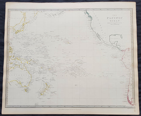
1840 SDUK Antique Map of The Pacific Ocean, North America, Japan, Australia, New Zealand
- Title : The Pacific Ocean.....Published by Chapman & Hall...May 15th 1840
- Size: 16in x 14in (410mm x 355m)
- Condition: (A+) Fine Condition
- Date : 1840
- Ref #: 11-0954-1
Description:
This hand coloured original steel-plate engraved antique map of The Pacific Ocean from North America, Japan, Australia & New Zealand was engraved by J & C Walker, in 1840 - the date is engraved at the foot of the map - and was published in the Chapman & Hall edition of the Society For the Diffusion of Useful Knowledge (SDUK) Atlas.
General Definitions:
Paper thickness and quality: - Heavy and stable
Paper color : - off white
Age of map color: - Original
Colors used: - Yellow, pink, green, blue
General color appearance: - Authentic
Paper size: - 16in x 14in (410mm x 355m)
Plate size: - 16in x 14in (410mm x 355m)
Margins: - Min 1/4in (5mm)
Imperfections:
Margins: - Light age toning
Plate area: - None
Verso: - None
Background:
The SDUK produced two landmark volumes of cartography in the first half of the 19th century. The first volume concentrated on areas of the old world, Europe, Africa, Great Britain etc. The second volume contained maps of the new world, America, South Asia, including US state maps, colonies of Australia, South Africa, South America etc. Also included were some of the finest engraved town and city plans published at that time.
The SDUK was published in its entirety or in part by many publishers including Baldwin and Cradock 1829-32, Chapman & Hall in 1844, Charles Knight & co. 1846 – 1852. G. Cox published the SDUK between 1852-3, Stanford 1857-70 and later revised edition were also published after Stanford. (Ref: Tooley, M&B)
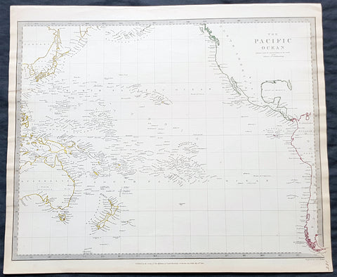
1840 SDUK Antique Map of The Pacific Ocean, North America, Japan, Australia, New Zealand
- Title : The Pacific Ocean.....Published by Chapman & Hall...May 15th 1840
- Size: 16in x 14in (410mm x 355m)
- Condition: (A+) Fine Condition
- Date : 1840
- Ref #: 24668
Description:
This hand coloured original steel-plate engraved antique map of The Pacific Ocean from North America, Japan, Australia & New Zealand was engraved by J & C Walker, in 1840 - the date is engraved at the foot of the map - and was published in the Chapman & Hall edition of the Society For the Diffusion of Useful Knowledge (SDUK) Atlas.
General Definitions:
Paper thickness and quality: - Heavy and stable
Paper color : - off white
Age of map color: - Original
Colors used: - Yellow, pink, green, blue
General color appearance: - Authentic
Paper size: - 16in x 14in (410mm x 355m)
Plate size: - 16in x 14in (410mm x 355m)
Margins: - Min 1/4in (5mm)
Imperfections:
Margins: - Light age toning
Plate area: - None
Verso: - None
Background:
The SDUK produced two landmark volumes of cartography in the first half of the 19th century. The first volume concentrated on areas of the old world, Europe, Africa, Great Britain etc. The second volume contained maps of the new world, America, South Asia, including US state maps, colonies of Australia, South Africa, South America etc. Also included were some of the finest engraved town and city plans published at that time.
The SDUK was published in its entirety or in part by many publishers including Baldwin and Cradock 1829-32, Chapman & Hall in 1844, Charles Knight & co. 1846 – 1852. G. Cox published the SDUK between 1852-3, Stanford 1857-70 and later revised edition were also published after Stanford. (Ref: Tooley, M&B)
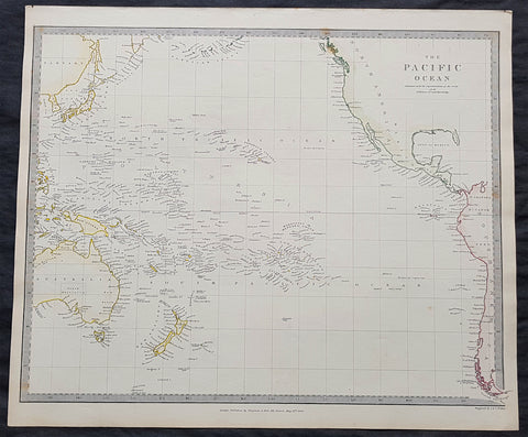
1840 SDUK Antique Map of The Pacific Ocean, North America, Japan, Australia, New Zealand
- Title : The Pacific Ocean.....Published by Chapman & Hall...May 15th 1840
- Size: 16in x 14in (410mm x 355m)
- Condition: (A+) Fine Condition
- Date : 1840
- Ref #: 11-0944
Description:
This hand coloured original steel-plate engraved antique map of The Pacific Ocean from North America, Japan, Australia & New Zealand was engraved by J & C Walker, in 1840 - the date is engraved at the foot of the map - and was published in the Chapman & Hall edition of the Society For the Diffusion of Useful Knowledge (SDUK) Atlas.
General Definitions:
Paper thickness and quality: - Heavy and stable
Paper color : - off white
Age of map color: - Original
Colors used: - Yellow, pink, green, blue
General color appearance: - Authentic
Paper size: - 16in x 14in (410mm x 355m)
Plate size: - 16in x 14in (410mm x 355m)
Margins: - Min 1/4in (5mm)
Imperfections:
Margins: - Light age toning
Plate area: - None
Verso: - None
Background:
The SDUK produced two landmark volumes of cartography in the first half of the 19th century. The first volume concentrated on areas of the old world, Europe, Africa, Great Britain etc. The second volume contained maps of the new world, America, South Asia, including US state maps, colonies of Australia, South Africa, South America etc. Also included were some of the finest engraved town and city plans published at that time.
The SDUK was published in its entirety or in part by many publishers including Baldwin and Cradock 1829-32, Chapman & Hall in 1844, Charles Knight & co. 1846 – 1852. G. Cox published the SDUK between 1852-3, Stanford 1857-70 and later revised edition were also published after Stanford. (Ref: Tooley, M&B)
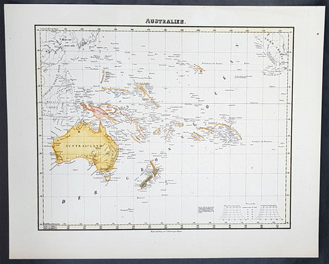
1854 Handtke & Flemming Antique Map of Australia, New Zealand, Pacific
- Title : Australien
- Date : 1854
- Condition: (A+) Fine Condition
- Ref: 40973
- Size: 17in x 14in (430mm x 355mm)
Description:
This hand coloured original steel-plate engraved antique highly detailed map of Australia, New Zealand, & The Pacific by Friedrich Handtke in 1854, was published in the Complete hand atlas of the recent description of the earth over all parts of the earth, Carl Flemming, Glougau.
General Definitions:
Paper thickness and quality: - Heavy and stable
Paper color : - off white
Age of map color: - Original
Colors used: - Yellow, red
General color appearance: - Authentic
Paper size: - 16in x 14in (405mm x 355mm)
Plate size: - 16in x 14in (405mm x 355mm)
Margins: - Min 1/2in (12mm)
Imperfections:
Margins: - Light spotting
Plate area: - Light spotting
Verso: - Light spotting
Background:
Australia is a sovereign country comprising the mainland of the Australian continent, the island of Tasmania and numerous smaller islands. It is the largest country in Oceania and the world\'s sixth-largest country by total area. The neighbouring countries are Papua New Guinea, Indonesia and East Timor to the north; the Solomon Islands and Vanuatu to the north-east; and New Zealand to the south-east. The population of 25 million is highly urbanised and heavily concentrated on the eastern seaboard. Australias capital is Canberra, and its largest city is Sydney. The country\'s other major metropolitan areas are Melbourne, Brisbane, Perth and Adelaide.
Australia was inhabited by indigenous Australians for about 60,000 years before the first British settlement in the late 18th century. It is documented that Aborigines spoke languages that can be classified into about 250 groups. After the European discovery of the continent by Dutch explorers in 1606, who named it New Holland, Australia\'s eastern half was claimed by Great Britain in 1770 and initially settled through penal transportation to the colony of New South Wales from 26 January 1788, a date which became Australia\'s national day. The population grew steadily in subsequent decades, and by the 1850s most of the continent had been explored and an additional five self-governing crown colonies established. On 1 January 1901, the six colonies federated, forming the Commonwealth of Australia. Australia has since maintained a stable liberal democratic political system that functions as a federal parliamentary constitutional monarchy comprising six states and ten territories.
Being the oldest, flattest and driest inhabited continent, with the least fertile soils, Australia has a landmass of 7,617,930 square kilometres. A megadiverse country, its size gives it a wide variety of landscapes, with deserts in the centre, tropical rainforests in the north-east and mountain ranges in the south-east. A gold rush began in Australia in the early 1850s, which boosted the population of the country. Nevertheless, its population density, 2.8 inhabitants per square kilometre, remains among the lowest in the world. Australia generates its income from various sources including mining-related exports, telecommunications, banking and manufacturing. Indigenous Australian rock art is the oldest and richest in the world, dating as far back as 60,000 years and spread across hundreds of thousands of sites.
The first recorded European sighting of the Australian mainland, and the first recorded European landfall on the Australian continent (in 1606), are attributed to the Dutch. The first ship and crew to chart the Australian coast and meet with Aboriginal people was the Duyfken captained by Dutch navigator, Willem Janszoon. He sighted the coast of Cape York Peninsula in early 1606, and made landfall on 26 February at the Pennefather River near the modern town of Weipa on Cape York. The Dutch charted the whole of the western and northern coastlines and named the island continent New Holland during the 17th century, but made no attempt at settlement. William Dampier, an English explorer and privateer, landed on the north-west coast of New Holland in 1688 and again in 1699 on a return trip. In 1770, James Cook sailed along and mapped the east coast, which he named New South Wales and claimed for Great Britain.
With the loss of its American colonies in 1783, the British Government sent a fleet of ships, the First Fleet, under the command of Captain Arthur Phillip, to establish a new penal colony in New South Wales. A camp was set up and the flag raised at Sydney Cove, Port Jackson, on 26 January 1788, a date which became Australia\'s national day, Australia Day. A British settlement was established in Van Diemens Land, now known as Tasmania, in 1803, and it became a separate colony in 1825. The United Kingdom formally claimed the western part of Western Australia (the Swan River Colony) in 1828. Separate colonies were carved from parts of New South Wales: South Australia in 1836, Victoria in 1851, and Queensland in 1859. The Northern Territory was founded in 1911 when it was excised from South Australia. South Australia was founded as a free province—it was never a penal colony. Victoria and Western Australia were also founded free, but later accepted transported convicts. A campaign by the settlers of New South Wales led to the end of convict transportation to that colony; the last convict ship arrived in 1848.
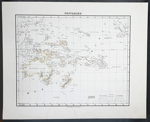
1854 Handtke & Flemming Antique Map of Australia, New Zealand, Pacific
- Title : Australien
- Date : 1854
- Condition: (A+) Fine Condition
- Ref: 31988
- Size: 17in x 14in (430mm x 355mm)
Description:
This hand coloured original steel-plate engraved antique highly detailed map of Australia, New Zealand, & The Pacific by Friedrich Handtke in 1854, was published in the Complete hand atlas of the recent description of the earth over all parts of the earth, Carl Flemming, Glougau.
General Definitions:
Paper thickness and quality: - Heavy and stable
Paper color : - off white
Age of map color: - Original
Colors used: - Yellow, red
General color appearance: - Authentic
Paper size: - 16in x 14in (405mm x 355mm)
Plate size: - 16in x 14in (405mm x 355mm)
Margins: - Min 1/2in (12mm)
Imperfections:
Margins: - Light spotting
Plate area: - Light spotting
Verso: - Light spotting
Background:
Australia is a sovereign country comprising the mainland of the Australian continent, the island of Tasmania and numerous smaller islands. It is the largest country in Oceania and the world\'s sixth-largest country by total area. The neighbouring countries are Papua New Guinea, Indonesia and East Timor to the north; the Solomon Islands and Vanuatu to the north-east; and New Zealand to the south-east. The population of 25 million is highly urbanised and heavily concentrated on the eastern seaboard. Australias capital is Canberra, and its largest city is Sydney. The country\'s other major metropolitan areas are Melbourne, Brisbane, Perth and Adelaide.
Australia was inhabited by indigenous Australians for about 60,000 years before the first British settlement in the late 18th century. It is documented that Aborigines spoke languages that can be classified into about 250 groups. After the European discovery of the continent by Dutch explorers in 1606, who named it New Holland, Australia\'s eastern half was claimed by Great Britain in 1770 and initially settled through penal transportation to the colony of New South Wales from 26 January 1788, a date which became Australia\'s national day. The population grew steadily in subsequent decades, and by the 1850s most of the continent had been explored and an additional five self-governing crown colonies established. On 1 January 1901, the six colonies federated, forming the Commonwealth of Australia. Australia has since maintained a stable liberal democratic political system that functions as a federal parliamentary constitutional monarchy comprising six states and ten territories.
Being the oldest, flattest and driest inhabited continent, with the least fertile soils, Australia has a landmass of 7,617,930 square kilometres. A megadiverse country, its size gives it a wide variety of landscapes, with deserts in the centre, tropical rainforests in the north-east and mountain ranges in the south-east. A gold rush began in Australia in the early 1850s, which boosted the population of the country. Nevertheless, its population density, 2.8 inhabitants per square kilometre, remains among the lowest in the world. Australia generates its income from various sources including mining-related exports, telecommunications, banking and manufacturing. Indigenous Australian rock art is the oldest and richest in the world, dating as far back as 60,000 years and spread across hundreds of thousands of sites.
The first recorded European sighting of the Australian mainland, and the first recorded European landfall on the Australian continent (in 1606), are attributed to the Dutch. The first ship and crew to chart the Australian coast and meet with Aboriginal people was the Duyfken captained by Dutch navigator, Willem Janszoon. He sighted the coast of Cape York Peninsula in early 1606, and made landfall on 26 February at the Pennefather River near the modern town of Weipa on Cape York. The Dutch charted the whole of the western and northern coastlines and named the island continent New Holland during the 17th century, but made no attempt at settlement. William Dampier, an English explorer and privateer, landed on the north-west coast of New Holland in 1688 and again in 1699 on a return trip. In 1770, James Cook sailed along and mapped the east coast, which he named New South Wales and claimed for Great Britain.
With the loss of its American colonies in 1783, the British Government sent a fleet of ships, the First Fleet, under the command of Captain Arthur Phillip, to establish a new penal colony in New South Wales. A camp was set up and the flag raised at Sydney Cove, Port Jackson, on 26 January 1788, a date which became Australia\'s national day, Australia Day. A British settlement was established in Van Diemens Land, now known as Tasmania, in 1803, and it became a separate colony in 1825. The United Kingdom formally claimed the western part of Western Australia (the Swan River Colony) in 1828. Separate colonies were carved from parts of New South Wales: South Australia in 1836, Victoria in 1851, and Queensland in 1859. The Northern Territory was founded in 1911 when it was excised from South Australia. South Australia was founded as a free province—it was never a penal colony. Victoria and Western Australia were also founded free, but later accepted transported convicts. A campaign by the settlers of New South Wales led to the end of convict transportation to that colony; the last convict ship arrived in 1848.
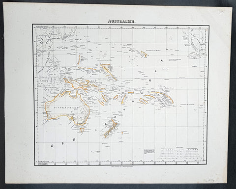
1854 Handtke & Flemming Antique Map of Australia, New Zealand, Pacific
- Title : Australien
- Date : 1854
- Condition: (A+) Fine Condition
- Ref: 31975
- Size: 17in x 14in (430mm x 355mm)
Description:
This hand coloured original steel-plate engraved antique highly detailed map of Australia, New Zealand, & The Pacific by Friedrich Handtke in 1854, was published in the Complete hand atlas of the recent description of the earth over all parts of the earth, Carl Flemming, Glougau.
General Definitions:
Paper thickness and quality: - Heavy and stable
Paper color : - off white
Age of map color: - Original
Colors used: - Yellow, red
General color appearance: - Authentic
Paper size: - 16in x 14in (405mm x 355mm)
Plate size: - 16in x 14in (405mm x 355mm)
Margins: - Min 1/2in (12mm)
Imperfections:
Margins: - Light spotting
Plate area: - Light spotting
Verso: - Light spotting
Background:
Australia is a sovereign country comprising the mainland of the Australian continent, the island of Tasmania and numerous smaller islands. It is the largest country in Oceania and the world\'s sixth-largest country by total area. The neighbouring countries are Papua New Guinea, Indonesia and East Timor to the north; the Solomon Islands and Vanuatu to the north-east; and New Zealand to the south-east. The population of 25 million is highly urbanised and heavily concentrated on the eastern seaboard. Australias capital is Canberra, and its largest city is Sydney. The country\'s other major metropolitan areas are Melbourne, Brisbane, Perth and Adelaide.
Australia was inhabited by indigenous Australians for about 60,000 years before the first British settlement in the late 18th century. It is documented that Aborigines spoke languages that can be classified into about 250 groups. After the European discovery of the continent by Dutch explorers in 1606, who named it New Holland, Australia\'s eastern half was claimed by Great Britain in 1770 and initially settled through penal transportation to the colony of New South Wales from 26 January 1788, a date which became Australia\'s national day. The population grew steadily in subsequent decades, and by the 1850s most of the continent had been explored and an additional five self-governing crown colonies established. On 1 January 1901, the six colonies federated, forming the Commonwealth of Australia. Australia has since maintained a stable liberal democratic political system that functions as a federal parliamentary constitutional monarchy comprising six states and ten territories.
Being the oldest, flattest and driest inhabited continent, with the least fertile soils, Australia has a landmass of 7,617,930 square kilometres. A megadiverse country, its size gives it a wide variety of landscapes, with deserts in the centre, tropical rainforests in the north-east and mountain ranges in the south-east. A gold rush began in Australia in the early 1850s, which boosted the population of the country. Nevertheless, its population density, 2.8 inhabitants per square kilometre, remains among the lowest in the world. Australia generates its income from various sources including mining-related exports, telecommunications, banking and manufacturing. Indigenous Australian rock art is the oldest and richest in the world, dating as far back as 60,000 years and spread across hundreds of thousands of sites.
The first recorded European sighting of the Australian mainland, and the first recorded European landfall on the Australian continent (in 1606), are attributed to the Dutch. The first ship and crew to chart the Australian coast and meet with Aboriginal people was the Duyfken captained by Dutch navigator, Willem Janszoon. He sighted the coast of Cape York Peninsula in early 1606, and made landfall on 26 February at the Pennefather River near the modern town of Weipa on Cape York. The Dutch charted the whole of the western and northern coastlines and named the island continent New Holland during the 17th century, but made no attempt at settlement. William Dampier, an English explorer and privateer, landed on the north-west coast of New Holland in 1688 and again in 1699 on a return trip. In 1770, James Cook sailed along and mapped the east coast, which he named New South Wales and claimed for Great Britain.
With the loss of its American colonies in 1783, the British Government sent a fleet of ships, the First Fleet, under the command of Captain Arthur Phillip, to establish a new penal colony in New South Wales. A camp was set up and the flag raised at Sydney Cove, Port Jackson, on 26 January 1788, a date which became Australia\'s national day, Australia Day. A British settlement was established in Van Diemens Land, now known as Tasmania, in 1803, and it became a separate colony in 1825. The United Kingdom formally claimed the western part of Western Australia (the Swan River Colony) in 1828. Separate colonies were carved from parts of New South Wales: South Australia in 1836, Victoria in 1851, and Queensland in 1859. The Northern Territory was founded in 1911 when it was excised from South Australia. South Australia was founded as a free province—it was never a penal colony. Victoria and Western Australia were also founded free, but later accepted transported convicts. A campaign by the settlers of New South Wales led to the end of convict transportation to that colony; the last convict ship arrived in 1848.
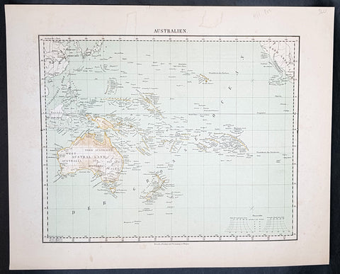
1854 Handtke & Flemming Antique Map of Australia, New Zealand, Pacific
- Title : Australien
- Date : 1854
- Condition: (A+) Fine Condition
- Ref: 32163
- Size: 17in x 14in (430mm x 355mm)
Description:
This hand coloured original steel-plate engraved antique highly detailed map of Australia, New Zealand, & The Pacific by Friedrich Handtke in 1854, was published in the Complete hand atlas of the recent description of the earth over all parts of the earth, Carl Flemming, Glougau.
General Definitions:
Paper thickness and quality: - Heavy and stable
Paper color : - off white
Age of map color: - Original
Colors used: - Yellow, red
General color appearance: - Authentic
Paper size: - 16in x 14in (405mm x 355mm)
Plate size: - 16in x 14in (405mm x 355mm)
Margins: - Min 1/2in (12mm)
Imperfections:
Margins: - Light spotting
Plate area: - Light spotting
Verso: - Light spotting
Background:
Australia is a sovereign country comprising the mainland of the Australian continent, the island of Tasmania and numerous smaller islands. It is the largest country in Oceania and the world\'s sixth-largest country by total area. The neighbouring countries are Papua New Guinea, Indonesia and East Timor to the north; the Solomon Islands and Vanuatu to the north-east; and New Zealand to the south-east. The population of 25 million is highly urbanised and heavily concentrated on the eastern seaboard. Australias capital is Canberra, and its largest city is Sydney. The country\'s other major metropolitan areas are Melbourne, Brisbane, Perth and Adelaide.
Australia was inhabited by indigenous Australians for about 60,000 years before the first British settlement in the late 18th century. It is documented that Aborigines spoke languages that can be classified into about 250 groups. After the European discovery of the continent by Dutch explorers in 1606, who named it New Holland, Australia\'s eastern half was claimed by Great Britain in 1770 and initially settled through penal transportation to the colony of New South Wales from 26 January 1788, a date which became Australia\'s national day. The population grew steadily in subsequent decades, and by the 1850s most of the continent had been explored and an additional five self-governing crown colonies established. On 1 January 1901, the six colonies federated, forming the Commonwealth of Australia. Australia has since maintained a stable liberal democratic political system that functions as a federal parliamentary constitutional monarchy comprising six states and ten territories.
Being the oldest, flattest and driest inhabited continent, with the least fertile soils, Australia has a landmass of 7,617,930 square kilometres. A megadiverse country, its size gives it a wide variety of landscapes, with deserts in the centre, tropical rainforests in the north-east and mountain ranges in the south-east. A gold rush began in Australia in the early 1850s, which boosted the population of the country. Nevertheless, its population density, 2.8 inhabitants per square kilometre, remains among the lowest in the world. Australia generates its income from various sources including mining-related exports, telecommunications, banking and manufacturing. Indigenous Australian rock art is the oldest and richest in the world, dating as far back as 60,000 years and spread across hundreds of thousands of sites.
The first recorded European sighting of the Australian mainland, and the first recorded European landfall on the Australian continent (in 1606), are attributed to the Dutch. The first ship and crew to chart the Australian coast and meet with Aboriginal people was the Duyfken captained by Dutch navigator, Willem Janszoon. He sighted the coast of Cape York Peninsula in early 1606, and made landfall on 26 February at the Pennefather River near the modern town of Weipa on Cape York. The Dutch charted the whole of the western and northern coastlines and named the island continent New Holland during the 17th century, but made no attempt at settlement. William Dampier, an English explorer and privateer, landed on the north-west coast of New Holland in 1688 and again in 1699 on a return trip. In 1770, James Cook sailed along and mapped the east coast, which he named New South Wales and claimed for Great Britain.
With the loss of its American colonies in 1783, the British Government sent a fleet of ships, the First Fleet, under the command of Captain Arthur Phillip, to establish a new penal colony in New South Wales. A camp was set up and the flag raised at Sydney Cove, Port Jackson, on 26 January 1788, a date which became Australia\'s national day, Australia Day. A British settlement was established in Van Diemens Land, now known as Tasmania, in 1803, and it became a separate colony in 1825. The United Kingdom formally claimed the western part of Western Australia (the Swan River Colony) in 1828. Separate colonies were carved from parts of New South Wales: South Australia in 1836, Victoria in 1851, and Queensland in 1859. The Northern Territory was founded in 1911 when it was excised from South Australia. South Australia was founded as a free province—it was never a penal colony. Victoria and Western Australia were also founded free, but later accepted transported convicts. A campaign by the settlers of New South Wales led to the end of convict transportation to that colony; the last convict ship arrived in 1848.
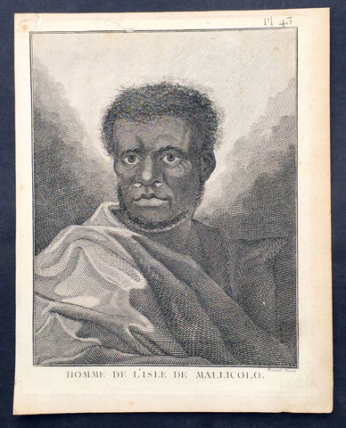
1778 Capt. Cook Antique Print Portrait A Man of Malakula Island Vanuatu in 1774
- Title : Homme de L Isle de Mallicolo
- Ref : 31831
- Size: 10in x 8in (255mm x 205mm)
- Date : 1778
- Condition: (A+) Fine Condition
Description:
This fine original copper-plate engraved antique print, portrait of a Man of the Island of Malakula (Mallicolo) in the Vanuatu group of Islands in the South Pacific, visited by Captain James Cook during his 2nd Voyage of Discovery in the South Seas in September 1774, was engraved by Robert Benard - after William Hodges - and was published in the 1778 French edition of Capt. James Cooks 2nd Voyage of Discovery to the South Seas A voyage towards the South Pole, and round the World. Performed in His Majestys ships the Resolution and Adventure, in the years 1772, 1773, 1774, and 1775..... Paris : Hotel de Thou ......1778
Cook Journal July, 1774
Arrival at The New Hebrides
On 17th Cook saw land bearing SW and later on decided this was the Australia Del Espiritu Santo of Quiros or what M. D. Bougainville calls the Great Cyclades. The island was Maewo. The next day its northern end was rounded in a gale and the ship sailed south between it and the island called by Bougainville the Isle of Lepers - Omba.
On 20th they crossed Patteson Passage with a view of geting to the South to explore the lands which lies there, and sailed down the west coast of Pentecost Isle (Raga). To the south they saw the island of Ambrin and behind it Paama and Epi. On 22nd, approaching Mallicollo (Malekula) we perceived a creek which had the appearence of a good harbour. Cook sent Lieutt [Richard] Pickersgill and the Master [Joseph Gilbert] in two Armd boats to Sound and look for Anchorage. The following day a good many [natives] came round us, some came in Canoes and others swam off\'... four I took into the Cabbin and made them various presents. Later, after some misunder-standing some natives began to Shoot Arrows... a Musquet discharged in the air and a four pounder over their heads sent them all off in the utmost confusion; those in the Cabbin leaped out of the Windows... About 9 o\'Clock we landed in the face of about 4 or 500 Men who were assembled on the Shore, armd with Bows and Arrows, clubs and Spears, but they made not the least opposission, on the contrary one Man gave his Arms to a nother and Met us in the water with a green branch in his hand, which [he] exchanged for the one I held in my hand. Just before departing Cook remarked they have not so much as a name for a Dog, consequently can have none, for which reason we left them a Dog and a Bitch.
General Definitions:
Paper thickness and quality: - Heavy and stable
Paper color : - off white
Age of map color: -
Colors used: -
General color appearance: -
Paper size: - 10in x 8in (255mm x 205mm)
Plate size: - 9 1/2in x 7 1/4in (240mm x 185mm)
Margins: - Min 1/2in (12mm)
Imperfections:
Margins: - Light soiling in margins
Plate area: - None
Verso: - None
Background:
Malakula Island also spelled Malekula, is the second-largest island in the nation of Vanuatu, in the Pacific Ocean region of Melanesia.
Discovered by the Spanish expedition of Pedro Fernández de Quirós in 1606 and visited by Captain Cook in 1774.
Vanuatu officially the Republic of Vanuatu is a Pacific island nation located in the South Pacific Ocean. The archipelago, which is of volcanic origin, is 1,750 kilometres east of northern Australia, 540 kilometres northeast of New Caledonia, east of New Guinea, southeast of the Solomon Islands, and west of Fiji.
Vanuatu was first inhabited by Melanesian people. The first Europeans to visit the islands were a Spanish expedition led by Portuguese navigator Fernandes de Queirós, who arrived on the largest island in 1606. Since the Portuguese and Spanish monarchies had been unified under the king of Spain in 1580 (following the vacancy of the Portuguese throne, which lasted for sixty years, until 1640, when the Portuguese monarchy was restored), Queirós claimed the archipelago for Spain, as part of the colonial Spanish East Indies, and named it La Austrialia del Espiritu Santo.
The Vanuatu group of islands first had contact with Europeans in 1606, when the Portuguese explorer Pedro Fernandes de Queiros, sailing for the Spanish Crown, arrived on the largest island and called the group of islands La Austrialia del Espiritu Santo or The Southern Land of the Holy Spirit, believing he had arrived in Terra Australis or Australia. The Spanish established a short-lived settlement at Big Bay on the north side of the island. The name Espiritu Santo remains to this day.
Europeans did not return until 1768, when Louis Antoine de Bougainville rediscovered the islands on 22 May, naming them the Great Cyclades. In 1774, Captain Cook named the islands the New Hebrides, a name that would last until independence in 1980.
William Hodges RA 1744 – 1797 was an English painter. He was a member of James Cooks second voyage to the Pacific Ocean, and is best known for the sketches and paintings of locations he visited on that voyage, including Table Bay, Tahiti, Easter Island, and the Antarctic.
Between 1772 and 1775 Hodges accompanied James Cook to the Pacific as the expeditions artist. Many of his sketches and wash paintings were adapted as engravings in the original published edition of Cooks journals from the voyage.
Most of the large-scale landscape oil paintings from his Pacific travels for which Hodges is best known were finished after his return to London; he received a salary from the Admiralty for the purposes of completing them. These paintings depicted a stronger light and shadow than had been usual in European landscape tradition. Contemporary art critics complained that his use of light and colour contrasts gave his paintings a rough and unfinished appearance.
Hodges also produced many valuable portrait sketches of Pacific islanders and scenes from the voyage involving members of the expedition..
Robert Bénard 1734 – 1777 was an 18th-century French engraver.
Specialized in the technique of engraving, Robert Ménard is mainly famous for having supplied a significant amount of plates (at least 1,800) to the Encyclopédie by Diderot & d\'Alembert from 1751.
Later, publisher Charles-Joseph Panckoucke reused many of his productions to illustrate the works of his catalog.