Welcome to Classical Images!
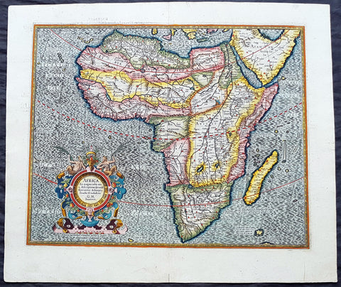
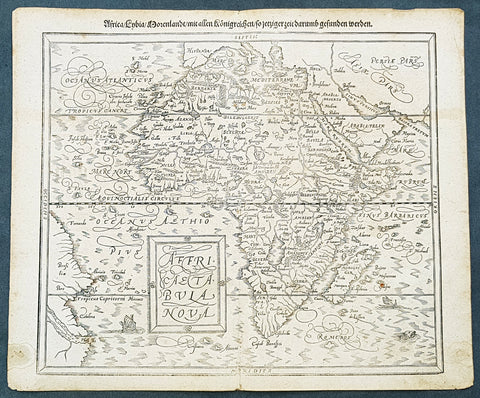
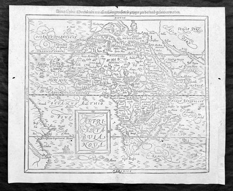
Description:This scarce striking original antique woodcut map of Africa was published in the 1597 edition of the German theologian Heinrich Buntings Itinerarium Sacrae.The pattern of rivers and major place names are modeled on those on the 1540 Africa map of Sebastian Münster, but these were necessarily distorted to fit the unusual outline of the continent as presented here. The ocean is engraved with distinctive wavy lines, and is decorated with a sailing ship, a merman, and what appears to be a swan. Cities marked on the map include Alexandria, Memphis, Cairo - and the Kingdom of the legendary Prester John.
General Description:Paper thickness and quality: - Heavy and stablePaper color: - Age of map color: - Colors used: - General color appearance: - Paper size: - 13 3/4in x 11 3/4in (350mm x 300mm)Plate size: - 13 3/4in x 11 3/4in (350mm x 300mm)Margins: - Min 1/8in (3mm)Imperfections:Margins: - Age toningPlate area: -Age toning, 4 small worm holesVerso: - Medium age toning, 3 old small re-enforcements on verso not affecting the image. Top left margin cropped close to border
Background:This map is based on the first modern map of Africa, which featured in Sebastian Münster’s Geographia (1540) and Cosmographia (1544). The map shows the entire continent along with the Sinai Peninsula, part of the Arabian Peninsula, and the southern edge of the Iberian Peninsula. Several large cities are marked with clusters of European-style buildings, including church steeples. Rolling mountain ranges break up the interior, along with massive rivers.The largest of these is of course the Nile River. It flows from the southern interior of the continent to the north. Following the Ptolemaic model that was also used in Münster’s earlier map, the Nile originates in the Montes Lunae, or the Mountains of the Moon. Bunting also locates Prester John’s kingdom near the Mountains of the Moon.One of the most distinct toponyms is Elephantophagi, near what is today the Congo. This refers to a tribe discussed by Strabo and Pliny who supposedly hunted and ate elephants and traded their hides and tusks across Africa.At sea, the water is carved in aesthetically pleasing zig-zag lines. A large ship is joined by a merman and a swan.
Heinrich Bünting (Hannover, 1545-1606)Heinrich Bünting was a protestant pastor and theologian. He was also a brewer in Hannover, and he was concerned with history and wrote a Braunschweigische Chronica in 1584. His main work was the popular Itinerarium Sacrae Scripturae, which after the first edition in Magdeburg in 1581 had many editions in German, Latin, Dutch, Swedish, Danish, Czech and English.The book gave an overview of biblical geography based on the travel descriptions of various notable people from the Old and New Testaments. It contained ten woodcut maps, including three figurative maps: the world depicted as a cloverleaf with Jerusalem in the centre, Europe in the shape of a crowned woman, and Asia as the winged horse Pegasus.