Products
1861 A D Bache Large Antique Map Napa River & Petaluma River Valleys, California
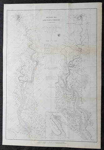
- Title : Petaluma and Napa Creeks California from a Trigonomitrical survey under the direction of A D Bache Superintendant of the Survey of the Coast of the United States....1861
- Size: 33in x 24 1/2in (840mm x 615mm)
- Condition: (A+) Fine Condition
- Date : 1861
- Ref #: 93037
Description:
This large scarce, original lithograph early antique map of Napa River Valley and Petaluma River Valley, California by Alexander Dallas Bache (great-grandson of Benjamin Franklin) in 1861 - dated - was published by the official chart-maker of the United States, the office of The US Coast Survey.
The Office of the Coast Survey, founded in 1807 by President Thomas Jefferson and Secretary of Commerce Albert Gallatin, is the oldest scientific organization in the U.S. Federal Government. Jefferson created the Survey of the Coast, as it was then called, in response to a need for accurate navigational charts of the new nation\\\'s coasts and harbors.
General Definitions:
Paper thickness and quality: - Heavy and stable
Paper color : - off white
Age of map color: -
Colors used: -
General color appearance: -
Paper size: - 33in x 24 1/2in (840mm x 615mm)
Plate size: - 33in x 24 1/2in (840mm x 615mm)
Margins: - Min 1/2in (12mm)
Imperfections:
Margins: - None
Plate area: - Folds as issued, light age toning
Verso: - Some folds re-enforced with archival tape
Background:
This is an uncommon 1861 U.S. Coast Survey nautical chart or map of the Napa River Valley and Petaluma River Valley, California. Essentially two maps on the same sheet, the left hand side of the sheet features a chart of the Petaluma Creek from Petaluma City as it empties into the San Pablo Bay. The chart on the right features the Napa Creek from Napa City to the Bay. Today this region enjoys international regard as the production center of some of the worlds finest wines.
The southern part of the Napa Creek as it empties into the San Pablo Bay between Mare Island and Vallejo is included in an inset near the bottom border and feature the Mare Island Straits. The straits, which are the mouth of the Napa River, are today popular for recreational boating and water sports.
The map offers excellent inland detail to the level of individual buildings, especially in Petaluma City, Napa City and in Vallejo and the Naval Yard. It also notes towns, roads, and inlets. Nautically this map offers a wealth of practical information for the mariner, including countless depth soundings and notes on tides, soundings and undersea dangers.
The triangulation for this chart was accomplished by G. A. Fairfield and A. F. Rodgers. The topography is the work of A. F. Rodgers and the hydrography was completed by a party under the command of James Alden. The entire work was produced in 1861 under the direction of A. D. Bache, Superintendent of the Survey of the Coast of the United States and one of the most influential American cartographers of the 19th century. Issued in the 1861 edition of the Superintendents Report.
U.S. Coast Survey (Office of Coast Survey)
The Office of Coast Survey is the official chart-maker of the United States. Set up in 1807, it is one of the U.S. governments oldest scientific organizations. In 1878 it was given the name of Coast and Geodetic Survey (C&GS). In 1970 it became part of the National Oceanic and Atmospheric Administration (NOAA).
The agency was established in 1807 when President Thomas Jefferson signed the document entitled An act to provide for surveying the coasts of the United States. While the bills objective was specific—to produce nautical charts—it reflected larger issues of concern to the new nation: national boundaries, commerce, and defence.
The early years were difficult. Ferdinand Rudolph Hassler, who was eventually to become the agencys first superintendent, went to England to collect scientific instruments but was unable to return through the duration of the War of 1812. After his return, he worked on a survey of the New York Harbor in 1817, but Congress stepped in to suspend the work because of tensions between civilian and military control of the agency. After several years under the control of the U.S. Army, the Survey of the Coast was reestablished in 1832, and President Andrew Jackson appointed Hassler as superintendent.
The U.S. Coast Survey was a civilian agency but, from the beginning, members of the Navy and Army were detailed to service with the Survey, and Navy ships were also detailed to its use. In general, army officers worked on topographic surveys on the land and maps based on the surveys, while navy officers worked on hydrographic surveys in coastal waters.
Alexander Dallas Bache, great-grandson of Benjamin Franklin, was the second Coast Survey superintendent. Bache was a physicist, scientist, and surveyor who established the first magnetic observatory and served as the first president of the National Academy of Sciences. Under Bache, Coast Survey quickly applied its resources to the Union cause during the Civil War. In addition to setting up additional lithographic presses to produce the thousands of charts required by the Navy and other vessels, Bache made a critical decision to send Coast Survey parties to work with blockading squadrons and armies in the field, producing hundreds of maps and charts. Bache detailed these activities in his annual reports to Congress.
Coast Survey cartographer Edwin Hergesheimer created the map showing the density of the slave population in the Southern states.
Bache was also one of four members of the governments Blockade Strategy Board, planning strategy to essentially strangle the South, economically and militarily. On April 16, 1861, President Lincoln issued a proclamation declaring the blockade of ports from South Carolina to Texas. Baches Notes on the Coast provided valuable information for Union naval forces.
Maps were of paramount importance in wartime:
It is certain that accurate maps must form the basis of well-conducted military operations, and that the best time to procure them is not when an attack is impending, or when the army waits, but when there is no hindrance to, or pressure upon, the surveyors. That no coast can be effectively attacked, defended, or blockaded without accurate maps and charts, has been fully proved by the events of the last two years, if, indeed, such a proposition required practical proof.
— Alexander Dallas Bache, 1862 report.
Coast Survey attracted some of the best and brightest scientists and naturalists. It commissioned the naturalist Louis Agassiz to conduct the first scientific study of the Florida reef system. James McNeill Whistler, who went on to paint the iconic Whistlers Mother, was a Coast Survey engraver. The naturalist John Muir was a guide and artist on Survey of the 39th Parallel across the Great Basin of Nevada and Utah.
The agencys men and women (women professionals were hired as early as 1845) led scientific and engineering activities through the decades. In 1926, they started production of aeronautical charts. During the height of the Great Depression, Coast and Geodetic Survey organized surveying parties and field offices that employed over 10,000 people, including many out-of-work engineers.
In World War II, C&GS sent over 1,000 civilian members and more than half of its commissioned officers to serve as hydrographers, artillery surveyors, cartographers, army engineers, intelligence officers, and geophysicists in all theaters of the war. Civilians on the home front produced over 100 million maps and charts for the Allied Forces. Eleven members of the C&GS gave their lives during the war.
Alexander Dallas Bache 1806 – 1867 was an American physicist, scientist, and surveyor who erected coastal fortifications and conducted a detailed survey to map the mid-eastern United States coastline. Originally an army engineer, he later became Superintendent of the U.S. Coast Survey, and built it into the foremost scientific institution in the country before the Civil War.
Alexander Bache was born in Philadelphia, the son of Richard Bache, Jr., and Sophia Burrell Dallas Bache. He came from a prominent family as he was the nephew of Vice-President George M. Dallas and naval hero Alexander J. Dallas. He was the grandson of Secretary of the Treasury Alexander Dallas and was the great-grandson of Benjamin Franklin.
Bache was a professor of natural philosophy and chemistry at the University of Pennsylvania from 1828 to 1841 and again from 1842 to 1843. He spent 1836–1838 in Europe on behalf of the trustees of what became Girard College; he was named president of the college after his return. Abroad, he examined European education systems, and on his return he published a valuable report. From 1839 to 1842, he served as the first president of Central High School of Philadelphia, one of the oldest public high schools in the United States.
In 1843, on the death of Professor Ferdinand Rudolph Hassler, Bache was appointed superintendent of the United States Coast Survey. He convinced the United States Congress of the value of this work and, by means of the liberal aid it granted, he completed the mapping of the whole coast by a skillful division of labor and the erection of numerous observing stations. In addition, magnetic and meteorological data were collected. Bache served as head of the Coast Survey for 24 years (until his death).

1861 Migeon Large Antique Map of North America, inset of Niagara Falls
- Title : Amerique Septentrionale
- Date : 1861
- Condition: (A+) Fine Condition
- Ref: 60567
- Size: 18in x 13 1/2in (460mm x 345mm)
Description:
This large fine beautifully hand coloured original antique map of North America - with an inset view of Niagara Falls - was published by J Migeon in his 1861 edition of Geographer Universal. (Ref: M&B; Tooley)
General Description:
Paper thickness and quality: - Heavy & stable
Paper color: - White
Age of map color: - Original
Colors used: - Pink, yellow, green, blue
General color appearance: - Authentic
Paper size: - 18in x 13 1/2in (460mm x 345mm)
Plate size: - 18in x 13 1/2in (460mm x 345mm)
Margins: - Min 1in (25mm)
Imperfections:
Margins: - None
Plate area: - None
Verso: - None
1865 James Wyld Large Antique Folding American Civil War Map - Extremely Rare
Antique Map
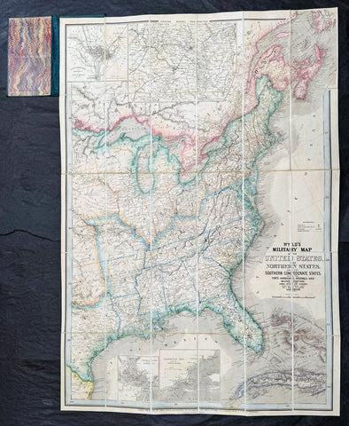
- Title : Wyld's Military Map Of The United States, The Northern States, And The Southern Confederate States: With The Forts, Harbours, Arsenals And Military Positions. James Wyld, 457 Strand; Charing Cross East And 2, Royal Exchange London. ......London, Published By James Wyld, Geographer To The Queen
- Date : 1865
- Size: 34 1/2in x 24in (875mm x 610mm)
- Condition: (A+) Fine Condition
- Ref: 35660
Description:
A very rare map of the United States first issued in 1861, during the Secession Crises that preceded the outbreak of the American Civil War, with this rare edition issued in January 1865 - dated at the foot of the map, only 4 months before the end of the war..
There are a few 1861 editions of this map for sale, currently on the market, but I have been unable to find an 1865 edition, either currently on the market or sold in the past.
General Definitions:
Paper thickness and quality: - Heavy and stable
Paper color : - off white
Age of map color: - Original
Colors used: - Yellow, green, blue, pink
General color appearance: - Authentic
Paper size: - 34 1/2in x 24in (875mm x 610mm)
Plate size: - 34 1/2in x 24in (875mm x 610mm)
Margins: - Min 1/2in (12mm)
Imperfections:
Margins: - None
Plate area: - None
Verso: - None
Background:
Wyld was particularly masterful at capturing political events throughout the world as they happened and leveraging his impressive publishing operation to quickly produce and distribute pertinent to the invested public. In this case, the map distinguishes between the 'Northern States' (orange border) and the 'Southern Confederate States' (blue border). Wyld here erroneously conflates slaveholding states with Confederate secessionist states - in particular, Missouri, Kentucky, Delaware, and Maryland, which allowed slavery but remained loyal to the Union. Arsenals, forts, and military posts highlighted and keyed, underscoring that 'war' was very much in the air. The map is also noteworthy for recognizes the apocryphal territory 'Chippewa', roughly corresponding to modern-day North Dakota.
This map is scarce to the market. Known institutions holdings at the Boston Public Library, the Library of Congress, Bibliothèque nationale de France, the David Rumsey Collection, among others. (Ref: M&B; Tooley; Clancy) (Ref: Tooley, Koeman, Burden)
Please note all items auctioned are genuine, we do not sell reproductions. A Certificate of Authenticity (COA) can be issued on request.
1869 Shannon & Rogers Birds Eye View of New York City - New York Manual
Antique Map
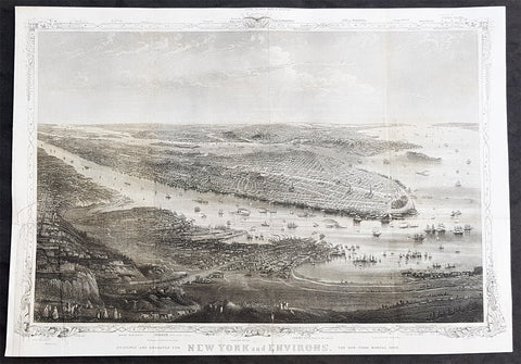
- Title : Designed and Engraved For New York and Environs. The New York Manual 1869
- Size: 16in x 12in (405mm x 275mm)
- Condition: (A+) Fine Condition
- Date : 1869
- Ref #: 93208
Description:
This original antique lithograph print of New York City by Joseph Shannon & WC Rogers in 1869 (dated) and was published in the 1869 edition of D T Valentines Manual of the Corporation of the City of New York or Valentines Manual.
General Definitions:
Paper thickness and quality: - Heavy and stable
Paper color : - off white
Age of map color: -
Colors used: -
General color appearance: -
Paper size: - 16in x 12in (405mm x 275mm)
Plate size: - 16in x 12in (405mm x 275mm)
Margins: - Min 1/2in (12mm)
Imperfections:
Margins: - Bottom right margin extended, not affecting the image
Plate area: - Folds as issued
Verso: - Folds as issued.
Background:
Rare view of the island of Manhattan, New York City by W. C. Rogers. The view depicts the entire island of Manhattan with Hoboken as well as parts of Brooklyn and Queens. Important buildings, especially churches are depicted with considerable accuracy. The harbor itself is full of sailing ships.
William C. Rogers 1860 - 1873 (active) a New York based lithographer best known for his engravings issued in conjuction with Joseph Shannons (Valentines) Manual of the Corporation for the City of New York.
Valentine, David Thomas 1801 - 1869
As the Clerk of the Common Council of New York City, Valentine edited and published a series of books on the history and contemporary facts of New York City entitled Manual of the Corporation Of The City of New York. They became know as Valentines Manuals with updates published annually, between 1841 & 1870. Valentine used his manuals to produce some of the rarest and most important maps & views of the city of New York, some of which occasionally appear on the market. His contribution to the historical record of New York city cannot be over stated.
1878-88 US Coast Survey 3 x Sheet Very Large Antique Map of The Delaware River
Antique Map
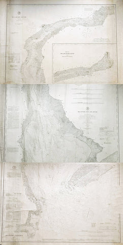
- Title : Delaware River..Issued in June 1881 CP Paterson; Delaware Bay and River..under the direction of FR Hassler and AD Bache...April 1878 CP Patterson; Delaware Entrance aids to navigation to 1887
- Size: 42in x 29in (1.07m x 735mm) each sheet
- Condition: (B) Good Condition
- Date : 178-88
- Ref #: 93111
Description:
Original scarce very large (78in x 36in when joined) antique three sheet map, on very heavy paper, of the Delaware River and Harbour. The map follows the river bordering the States of New Jersey, Delaware & Pennsylvania, from the river mouth to Philadelphia PA, by AD Bache and FR Hassler and was first issued by the US Coast Survey in 1848. These 3 sheets were issued, updated in 1887, 1881 & 1887 respectively.
General Definitions:
Paper thickness and quality: - Heavy and stable
Paper color : - off white
Age of map color: -
Colors used: -
General color appearance: -
Paper size: - 42in x 29in (1.07m x 735mm) each sheet (approx)
Plate size: - 42in x 29in (1.07m x 735mm) each sheet (approx)
Margins: - Min 1/2in (12mm)
Imperfections:
Margins: - Soiling and creasing
Plate area: - Soiling and vertical creasing
Verso: - Soiling and vertical creasing
Background:
While these maps appear together occasionally on the market, and can be found bound into early US Coast Survey volumes, the thin paper and browned folds invariably leaves it in problematic condition. The present example is a separately issued example on very heavy paper. Many of the coast survey maps were issued in very limited numbers on heavy paper for presentation purposes or use at sea, making any example of these three maps together rare.
U.S. Coast Survey (Office of Coast Survey)
The Office of Coast Survey is the official chart-maker of the United States. Set up in 1807, it is one of the U.S. governments oldest scientific organizations. In 1878 it was given the name of Coast and Geodetic Survey (C&GS). In 1970 it became part of the National Oceanic and Atmospheric Administration (NOAA).
The agency was established in 1807 when President Thomas Jefferson signed the document entitled An act to provide for surveying the coasts of the United States. While the bills objective was specific—to produce nautical charts—it reflected larger issues of concern to the new nation: national boundaries, commerce, and defence.
The early years were difficult. Ferdinand Rudolph Hassler, who was eventually to become the agencys first superintendent, went to England to collect scientific instruments but was unable to return through the duration of the War of 1812. After his return, he worked on a survey of the New York Harbor in 1817, but Congress stepped in to suspend the work because of tensions between civilian and military control of the agency. After several years under the control of the U.S. Army, the Survey of the Coast was reestablished in 1832, and President Andrew Jackson appointed Hassler as superintendent.
The U.S. Coast Survey was a civilian agency but, from the beginning, members of the Navy and Army were detailed to service with the Survey, and Navy ships were also detailed to its use. In general, army officers worked on topographic surveys on the land and maps based on the surveys, while navy officers worked on hydrographic surveys in coastal waters.
Alexander Dallas Bache, great-grandson of Benjamin Franklin, was the second Coast Survey superintendent. Bache was a physicist, scientist, and surveyor who established the first magnetic observatory and served as the first president of the National Academy of Sciences. Under Bache, Coast Survey quickly applied its resources to the Union cause during the Civil War. In addition to setting up additional lithographic presses to produce the thousands of charts required by the Navy and other vessels, Bache made a critical decision to send Coast Survey parties to work with blockading squadrons and armies in the field, producing hundreds of maps and charts. Bache detailed these activities in his annual reports to Congress.
Coast Survey cartographer Edwin Hergesheimer created the map showing the density of the slave population in the Southern states.
Bache was also one of four members of the governments Blockade Strategy Board, planning strategy to essentially strangle the South, economically and militarily. On April 16, 1861, President Lincoln issued a proclamation declaring the blockade of ports from South Carolina to Texas. Baches Notes on the Coast provided valuable information for Union naval forces.
Maps were of paramount importance in wartime:
It is certain that accurate maps must form the basis of well-conducted military operations, and that the best time to procure them is not when an attack is impending, or when the army waits, but when there is no hindrance to, or pressure upon, the surveyors. That no coast can be effectively attacked, defended, or blockaded without accurate maps and charts, has been fully proved by the events of the last two years, if, indeed, such a proposition required practical proof.
— Alexander Dallas Bache, 1862 report.
Coast Survey attracted some of the best and brightest scientists and naturalists. It commissioned the naturalist Louis Agassiz to conduct the first scientific study of the Florida reef system. James McNeill Whistler, who went on to paint the iconic Whistlers Mother, was a Coast Survey engraver. The naturalist John Muir was a guide and artist on Survey of the 39th Parallel across the Great Basin of Nevada and Utah.
The agencys men and women (women professionals were hired as early as 1845) led scientific and engineering activities through the decades. In 1926, they started production of aeronautical charts. During the height of the Great Depression, Coast and Geodetic Survey organized surveying parties and field offices that employed over 10,000 people, including many out-of-work engineers.
In World War II, C&GS sent over 1,000 civilian members and more than half of its commissioned officers to serve as hydrographers, artillery surveyors, cartographers, army engineers, intelligence officers, and geophysicists in all theaters of the war. Civilians on the home front produced over 100 million maps and charts for the Allied Forces. Eleven members of the C&GS gave their lives during the war.
Alexander Dallas Bache 1806 – 1867 was an American physicist, scientist, and surveyor who erected coastal fortifications and conducted a detailed survey to map the mid-eastern United States coastline. Originally an army engineer, he later became Superintendent of the U.S. Coast Survey, and built it into the foremost scientific institution in the country before the Civil War.
Alexander Bache was born in Philadelphia, the son of Richard Bache, Jr., and Sophia Burrell Dallas Bache. He came from a prominent family as he was the nephew of Vice-President George M. Dallas and naval hero Alexander J. Dallas. He was the grandson of Secretary of the Treasury Alexander Dallas and was the great-grandson of Benjamin Franklin.
Bache was a professor of natural philosophy and chemistry at the University of Pennsylvania from 1828 to 1841 and again from 1842 to 1843. He spent 1836–1838 in Europe on behalf of the trustees of what became Girard College; he was named president of the college after his return. Abroad, he examined European education systems, and on his return he published a valuable report. From 1839 to 1842, he served as the first president of Central High School of Philadelphia, one of the oldest public high schools in the United States.
In 1843, on the death of Professor Ferdinand Rudolph Hassler, Bache was appointed superintendent of the United States Coast Survey. He convinced the United States Congress of the value of this work and, by means of the liberal aid it granted, he completed the mapping of the whole coast by a skillful division of labor and the erection of numerous observing stations. In addition, magnetic and meteorological data were collected. Bache served as head of the Coast Survey for 24 years (until his death).
Please note all items auctioned are genuine, we do not sell reproductions. A Certificate of Authenticity (COA) can be issued on request.
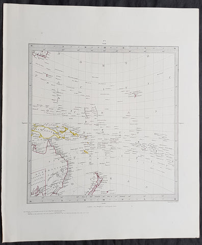
Copy of 1840 SDUK Antique Gnomonic Map East Australia, New Zealand South Pacific
- Title : Published by the Society for the Diffusion of Useful Knowledge
- Size: 16in x 14in (410mm x 355m)
- Condition: (A+) Fine Condition
- Date : 1840
- Ref #: 11-0984
Description:
This hand coloured original steel-plate engraved antique Gnomonic Map of eastern Australia, New Zealand & The South Pacific was engraved by J & C Walker, in 1840 and was published in the Chapman & Hall edition of the Society For the Diffusion of Useful Knowledge (SDUK) Atlas.
A gnomonic map projection displays all great circles as straight lines, resulting in any line segment on a gnomonic map showing a geodesic, the shortest route between the segment\'s two endpoints. This is achieved by casting surface points of the sphere onto a tangent plane, each landing where a ray from the center of the sphere passes through the point on the surface and then on to the plane. No distortion occurs at the tangent point, but distortion increases rapidly away from it. Less than half of the sphere can be projected onto a finite map. Consequently a rectilinear photographic lens cannot image more than 180 degrees.
General Definitions:
Paper thickness and quality: - Heavy and stable
Paper color : - off white
Age of map color: - Original
Colors used: - Yellow, pink, green, blue
General color appearance: - Authentic
Paper size: - 16in x 14in (410mm x 355m)
Plate size: - 16in x 14in (410mm x 355m)
Margins: - Min 1/4in (5mm)
Imperfections:
Margins: - Light age toning
Plate area: - None
Verso: - None
Background:
The SDUK produced two landmark volumes of cartography in the first half of the 19th century. The first volume concentrated on areas of the old world, Europe, Africa, Great Britain etc. The second volume contained maps of the new world, America, South Asia, including US state maps, colonies of Australia, South Africa, South America etc. Also included were some of the finest engraved town and city plans published at that time.
The SDUK was published in its entirety or in part by many publishers including Baldwin and Cradock 1829-32, Chapman & Hall in 1844, Charles Knight & co. 1846 – 1852. G. Cox published the SDUK between 1852-3, Stanford 1857-70 and later revised edition were also published after Stanford. (Ref: Tooley, M&B)