Products
1745 Nicolas Tindal Original Antique Map Battle of Malplaquet, Northern France in 1709
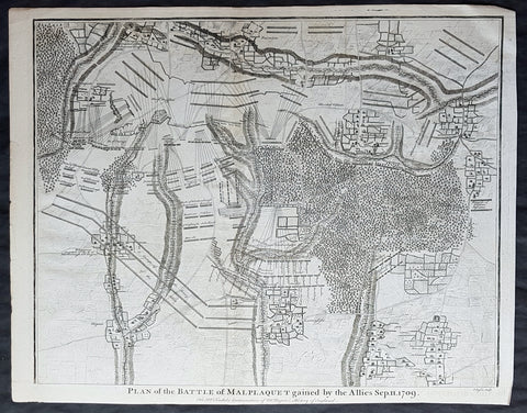
- Title : Plan of the Battle of Malplaquet gained by the Allies Sep. 11 1709.
- Size: 19 1/2in x 15 1/2in (495mm x 395mm)
- Ref #: 15659
- Date : 1745
- Condition: (A+) Fine Condition
Description:
This original copper-plate engraved antique map, plan of the Battle of Malplaquet, northern France in 1709 - during the Spanish War of Succession (1701-13) - was engrvaed by John Basire and was published in the 1745 edition of Nicholas Tindals Continuation of Mr. Rapin\'s History of England.
General Definitions:
Paper thickness and quality: - Heavy and stable
Paper color : - off white
Age of map color: -
Colors used: -
General color appearance: -
Paper size: - 19 1/2in x 15 1/2in (495mm x 395mm)
Plate size: - 19 1/2in x 15 1/2in (495mm x 395mm)
Margins: - Min 1/2in (12mm)
Imperfections:
Margins: - None
Plate area: - None
Verso: - None
Background:
The Battle of Malplaquet, fought on 11 September 1709, was one of the main battles of the War of the Spanish Succession. Led by the Duke of Marlborough, the army of the Grand Alliance attacked and defeated the French army near Malplaquet under the command of Marshal Villars. The heavy losses suffered by the Allies caused the battle to be considered a Pyrrhic victory.
1745 Nicolas Tindal Original Antique Map Battle of Malplaquet, Northern France in 1709
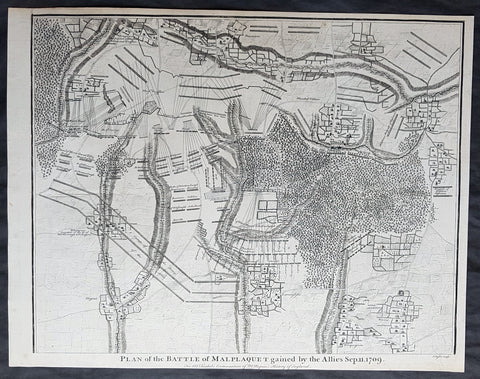
- Title : Plan of the Battle of Malplaquet gained by the Allies Sep. 11 1709.
- Size: 19 1/2in x 15 1/2in (495mm x 395mm)
- Ref #: 22154
- Date : 1745
- Condition: (A+) Fine Condition
Description:
This original copper-plate engraved antique map, plan of the Battle of Malplaquet, northern France in 1709 - during the Spanish War of Succession (1701-13) - was engrvaed by John Basire and was published in the 1745 edition of Nicholas Tindals Continuation of Mr. Rapin\'s History of England.
General Definitions:
Paper thickness and quality: - Heavy and stable
Paper color : - off white
Age of map color: -
Colors used: -
General color appearance: -
Paper size: - 19 1/2in x 15 1/2in (495mm x 395mm)
Plate size: - 19 1/2in x 15 1/2in (495mm x 395mm)
Margins: - Min 1/2in (12mm)
Imperfections:
Margins: - None
Plate area: - None
Verso: - None
Background:
The Battle of Malplaquet, fought on 11 September 1709, was one of the main battles of the War of the Spanish Succession. Led by the Duke of Marlborough, the army of the Grand Alliance attacked and defeated the French army near Malplaquet under the command of Marshal Villars. The heavy losses suffered by the Allies caused the battle to be considered a Pyrrhic victory.
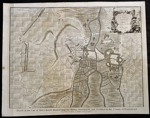
1745 Tindal Antique Map Battle Plan of Siege of Bouchain, Calais, France in 1711
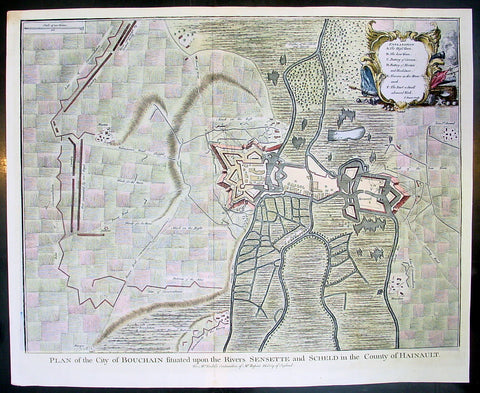
- Title : Plan of the City of Bouchain Situated upon the Rivers Sensette and Scheld in the County of Hainault
- Size: 19 1/2in x 15 1/2in (495mm x 395mm)
- Ref #: 22198
- Date : 1745
- Condition: (A+) Fine Condition
Description:
This beautifully hand coloured original copper-plate engraved antique map, battle plan & birds eye view of the French city of Bouchain on the Schedlt River, in the Pas-de-Calais dept. in northern France - during the Spanish War of Succession (1701-13) - was engraved by John Basire and was published in the 1745 edition of Nicholas Tindals Continuation of Mr. Rapin\'s History of England.
General Definitions:
Paper thickness and quality: - Heavy and stable
Paper color : - off white
Age of map color: - Early
Colors used: - Pink, blue, green, yellow
General color appearance: - Authentic
Paper size: - 19 1/2in x 15 1/2in (495mm x 395mm)
Plate size: - 19 1/2in x 15 1/2in (495mm x 395mm)
Margins: - Min 1/2in (12mm)
Imperfections:
Margins: - None
Plate area: - Folds as issued
Verso: - None
Background:
The Siege of Bouchain (9 August – 12 September 1711), following the Passage of the Lines of Ne Plus Ultra (5 August 1711), was a siege of the War of the Spanish Succession, and the last major victory of John Churchill, 1st Duke of Marlborough. Marlborough broke through the French defensive lines and took Bouchain after a siege of 34 days. Its capture left Cambrai the only French-held fortress between the allied army and Paris.
Throughout the early summer of 1711 Marlborough\'s army, having taken the important fortress of Douai the previous year, manoeuvred indecisively in northern France, blocked by the French Lines of Ne Plus Ultra – a massive series of fieldworks stretching from the Channel coast to the Ardennes at Namur. The allied army had been weakened by the withdrawal of Prince Eugene\'s army to cover the upper Rhine, as the deposed Elector of Bavaria attempted to take advantage of the disruption caused by the death of the Emperor Joseph. On 6 July, Marlborough captured the small fortress of Arleux, just to the north of the Lines, west of Bouchain, both to deny its use to the French as a sally-port, and to secure the water supply to Douai, which could be cut off by damming the canal that supplied the town. The Duke was then wrong-footed by Villars as the French army crossed the Lines on 22/23 July and retook Arleux, with the allied army too far to the west to intervene in time, and the defences were levelled before the French retreated back across the Lines. Marlborough, initially furious, soon retook the initiative by marching his army as if to assault the Lines near Arras, and carrying out a detailed personal reconnaissance there on 4 August in full view of Villars\' covering army. That night the army struck camp, leaving their campfires burning to deceive the French, and marched eastwards to Arleux. At midnight a force from Douai under Cadogan crossed the unguarded French lines, and by 8 am the advance guard of the main army was also crossing over. Villars, arriving on the scene with a few hundred cavalry, realised he had been outmanoeuvred, and though he attempted to offer battle in front of Bourlon Wood, Marlborough declined to attack, the Marshal\'s position being even stronger than the one in which he had given Marlborough\'s army such a mauling two years earlier at Malplaquet. He thus drew off and attempted to hinder Marlborough\'s siege of Bouchain which followed.
To defend the town Bouchain\'s governor, de Ravignau, had some 5,000 men against Marlborough\'s besieging army of 30,000, and the advantage of one of the strongest fortresses left to France, surrounded by the marshy land of the confluence of the rivers Scheldt and Sensée. In addition, Villars\' strong army had taken up position to the west of the allied camp, and had managed to open a tenuous link to the besieged garrison. Marlborough responded by using earthwork gun batteries to counter Villars, used a crack assault force managed by 18 August to once more cut the Marshal\'s communication with Bouchain, and established a fieldwork-protected corridor from the siege camp to his main supply port at Marchiennes on the Scarpe. Frequent raids by Villars on both the supply convoys on the Scarpe, and towards Douai, failed to interrupt the siege, and the garrison marched out to become prisoners of war on 13 September 1711.
Bouchain was Marlborough\'s last campaign. On the last day of the year he was stripped of his position as Captain-General, and of all his other offices. Command of the army on the continent for the campaign of 1712 was given to the Duke of Ormonde, and strict limitations were placed on his freedom of movement. Particularly he was prohibited from engaging the French in battle, as Anglo-French peace talks were well advanced, and the opportunity of seizing Cambrai and marching on Paris, opened by Marlborough\'s gains the year before, was abandoned. Before the year was out, the British army would withdraw from the alliance, leaving the remaining allies, under Eugene of Savoy to be defeated at Denain.
1745 Tindal Antique Map Battle Plan of Siege of Bouchain, Calais, France in 1711
Antique Map
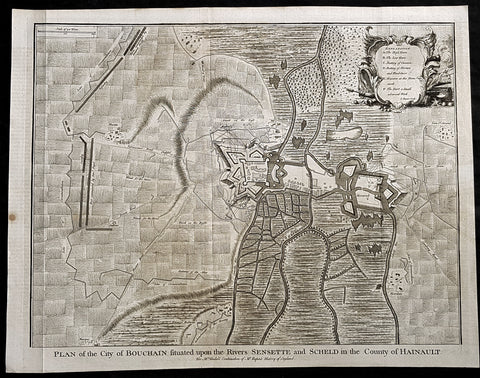
- Title : Plan of the City of Bouchain Situated upon the Rivers Sensette and Scheld in the County of Hainault
- Size: 19 1/2in x 15 1/2in (495mm x 395mm)
- Ref #: 22198
- Date : 1745
- Condition: (A+) Fine Condition
Description:
This original copper-plate engraved antique map, battle plan & birds eye view of the French city of Bouchain on the Schedlt River, in the Pas-de-Calais dept. in northern France - during the Spanish War of Succession (1701-13) - was engraved by John Basire and was published in the 1745 edition of Nicholas Tindals Continuation of Mr. Rapin\'s History of England.
General Definitions:
Paper thickness and quality: - Heavy and stable
Paper color : - off white
Age of map color: -
Colors used: -
General color appearance: -
Paper size: - 19 1/2in x 15 1/2in (495mm x 395mm)
Plate size: - 19 1/2in x 15 1/2in (495mm x 395mm)
Margins: - Min 1/2in (12mm)
Imperfections:
Margins: - None
Plate area: - Folds as issued
Verso: - None
Background:
The Siege of Bouchain (9 August – 12 September 1711), following the Passage of the Lines of Ne Plus Ultra (5 August 1711), was a siege of the War of the Spanish Succession, and the last major victory of John Churchill, 1st Duke of Marlborough. Marlborough broke through the French defensive lines and took Bouchain after a siege of 34 days. Its capture left Cambrai the only French-held fortress between the allied army and Paris.
Throughout the early summer of 1711 Marlborough\'s army, having taken the important fortress of Douai the previous year, manoeuvred indecisively in northern France, blocked by the French Lines of Ne Plus Ultra – a massive series of fieldworks stretching from the Channel coast to the Ardennes at Namur. The allied army had been weakened by the withdrawal of Prince Eugene\'s army to cover the upper Rhine, as the deposed Elector of Bavaria attempted to take advantage of the disruption caused by the death of the Emperor Joseph. On 6 July, Marlborough captured the small fortress of Arleux, just to the north of the Lines, west of Bouchain, both to deny its use to the French as a sally-port, and to secure the water supply to Douai, which could be cut off by damming the canal that supplied the town. The Duke was then wrong-footed by Villars as the French army crossed the Lines on 22/23 July and retook Arleux, with the allied army too far to the west to intervene in time, and the defences were levelled before the French retreated back across the Lines. Marlborough, initially furious, soon retook the initiative by marching his army as if to assault the Lines near Arras, and carrying out a detailed personal reconnaissance there on 4 August in full view of Villars\' covering army. That night the army struck camp, leaving their campfires burning to deceive the French, and marched eastwards to Arleux. At midnight a force from Douai under Cadogan crossed the unguarded French lines, and by 8 am the advance guard of the main army was also crossing over. Villars, arriving on the scene with a few hundred cavalry, realised he had been outmanoeuvred, and though he attempted to offer battle in front of Bourlon Wood, Marlborough declined to attack, the Marshal\'s position being even stronger than the one in which he had given Marlborough\'s army such a mauling two years earlier at Malplaquet. He thus drew off and attempted to hinder Marlborough\'s siege of Bouchain which followed.
To defend the town Bouchain\'s governor, de Ravignau, had some 5,000 men against Marlborough\'s besieging army of 30,000, and the advantage of one of the strongest fortresses left to France, surrounded by the marshy land of the confluence of the rivers Scheldt and Sensée. In addition, Villars\' strong army had taken up position to the west of the allied camp, and had managed to open a tenuous link to the besieged garrison. Marlborough responded by using earthwork gun batteries to counter Villars, used a crack assault force managed by 18 August to once more cut the Marshal\'s communication with Bouchain, and established a fieldwork-protected corridor from the siege camp to his main supply port at Marchiennes on the Scarpe. Frequent raids by Villars on both the supply convoys on the Scarpe, and towards Douai, failed to interrupt the siege, and the garrison marched out to become prisoners of war on 13 September 1711.
Bouchain was Marlborough\'s last campaign. On the last day of the year he was stripped of his position as Captain-General, and of all his other offices. Command of the army on the continent for the campaign of 1712 was given to the Duke of Ormonde, and strict limitations were placed on his freedom of movement. Particularly he was prohibited from engaging the French in battle, as Anglo-French peace talks were well advanced, and the opportunity of seizing Cambrai and marching on Paris, opened by Marlborough\'s gains the year before, was abandoned. Before the year was out, the British army would withdraw from the alliance, leaving the remaining allies, under Eugene of Savoy to be defeated at Denain.

1745 Tindal Antique Map Battle Plan of Siege of Bouchain, Calais, France in 1711
Antique Map
- Title : Plan of the City of Bouchain Situated upon the Rivers Sensette and Scheld in the County of Hainault
- Size: 19 1/2in x 15 1/2in (495mm x 395mm)
- Ref #: 22156-1
- Date : 1745
- Condition: (A+) Fine Condition
Description:
This original copper-plate engraved antique map, battle plan & birds eye view of the French city of Bouchain on the Schedlt River, in the Pas-de-Calais dept. in northern France - during the Spanish War of Succession (1701-13) - was engraved by John Basire and was published in the 1745 edition of Nicholas Tindals Continuation of Mr. Rapin\'s History of England.
General Definitions:
Paper thickness and quality: - Heavy and stable
Paper color : - off white
Age of map color: -
Colors used: -
General color appearance: -
Paper size: - 19 1/2in x 15 1/2in (495mm x 395mm)
Plate size: - 19 1/2in x 15 1/2in (495mm x 395mm)
Margins: - Min 1/2in (12mm)
Imperfections:
Margins: - None
Plate area: - Folds as issued
Verso: - None
Background:
The Siege of Bouchain (9 August – 12 September 1711), following the Passage of the Lines of Ne Plus Ultra (5 August 1711), was a siege of the War of the Spanish Succession, and the last major victory of John Churchill, 1st Duke of Marlborough. Marlborough broke through the French defensive lines and took Bouchain after a siege of 34 days. Its capture left Cambrai the only French-held fortress between the allied army and Paris.
Throughout the early summer of 1711 Marlborough\'s army, having taken the important fortress of Douai the previous year, manoeuvred indecisively in northern France, blocked by the French Lines of Ne Plus Ultra – a massive series of fieldworks stretching from the Channel coast to the Ardennes at Namur. The allied army had been weakened by the withdrawal of Prince Eugene\'s army to cover the upper Rhine, as the deposed Elector of Bavaria attempted to take advantage of the disruption caused by the death of the Emperor Joseph. On 6 July, Marlborough captured the small fortress of Arleux, just to the north of the Lines, west of Bouchain, both to deny its use to the French as a sally-port, and to secure the water supply to Douai, which could be cut off by damming the canal that supplied the town. The Duke was then wrong-footed by Villars as the French army crossed the Lines on 22/23 July and retook Arleux, with the allied army too far to the west to intervene in time, and the defences were levelled before the French retreated back across the Lines. Marlborough, initially furious, soon retook the initiative by marching his army as if to assault the Lines near Arras, and carrying out a detailed personal reconnaissance there on 4 August in full view of Villars\' covering army. That night the army struck camp, leaving their campfires burning to deceive the French, and marched eastwards to Arleux. At midnight a force from Douai under Cadogan crossed the unguarded French lines, and by 8 am the advance guard of the main army was also crossing over. Villars, arriving on the scene with a few hundred cavalry, realised he had been outmanoeuvred, and though he attempted to offer battle in front of Bourlon Wood, Marlborough declined to attack, the Marshal\'s position being even stronger than the one in which he had given Marlborough\'s army such a mauling two years earlier at Malplaquet. He thus drew off and attempted to hinder Marlborough\'s siege of Bouchain which followed.
To defend the town Bouchain\'s governor, de Ravignau, had some 5,000 men against Marlborough\'s besieging army of 30,000, and the advantage of one of the strongest fortresses left to France, surrounded by the marshy land of the confluence of the rivers Scheldt and Sensée. In addition, Villars\' strong army had taken up position to the west of the allied camp, and had managed to open a tenuous link to the besieged garrison. Marlborough responded by using earthwork gun batteries to counter Villars, used a crack assault force managed by 18 August to once more cut the Marshal\'s communication with Bouchain, and established a fieldwork-protected corridor from the siege camp to his main supply port at Marchiennes on the Scarpe. Frequent raids by Villars on both the supply convoys on the Scarpe, and towards Douai, failed to interrupt the siege, and the garrison marched out to become prisoners of war on 13 September 1711.
Bouchain was Marlborough\'s last campaign. On the last day of the year he was stripped of his position as Captain-General, and of all his other offices. Command of the army on the continent for the campaign of 1712 was given to the Duke of Ormonde, and strict limitations were placed on his freedom of movement. Particularly he was prohibited from engaging the French in battle, as Anglo-French peace talks were well advanced, and the opportunity of seizing Cambrai and marching on Paris, opened by Marlborough\'s gains the year before, was abandoned. Before the year was out, the British army would withdraw from the alliance, leaving the remaining allies, under Eugene of Savoy to be defeated at Denain.
1745 Tindal Antique Map Battle Plan of Siege of Bouchain, Calais, France in 1711
Antique Map
- Title : Plan of the City of Bouchain Situated upon the Rivers Sensette and Scheld in the County of Hainault
- Size: 19 1/2in x 15 1/2in (495mm x 395mm)
- Ref #: 22156-1
- Date : 1745
- Condition: (A+) Fine Condition
Description:
This original copper-plate engraved antique map, battle plan & birds eye view of the French city of Bouchain on the Schedlt River, in the Pas-de-Calais dept. in northern France - during the Spanish War of Succession (1701-13) - was engraved by John Basire and was published in the 1745 edition of Nicholas Tindals Continuation of Mr. Rapin\'s History of England.
General Definitions:
Paper thickness and quality: - Heavy and stable
Paper color : - off white
Age of map color: - Early
Colors used: - Pink, blue, green, yellow
General color appearance: - Authentic
Paper size: - 19 1/2in x 15 1/2in (495mm x 395mm)
Plate size: - 19 1/2in x 15 1/2in (495mm x 395mm)
Margins: - Min 1/2in (12mm)
Imperfections:
Margins: - None
Plate area: - Folds as issued
Verso: - None
Background:
The Siege of Bouchain (9 August – 12 September 1711), following the Passage of the Lines of Ne Plus Ultra (5 August 1711), was a siege of the War of the Spanish Succession, and the last major victory of John Churchill, 1st Duke of Marlborough. Marlborough broke through the French defensive lines and took Bouchain after a siege of 34 days. Its capture left Cambrai the only French-held fortress between the allied army and Paris.
Throughout the early summer of 1711 Marlborough\'s army, having taken the important fortress of Douai the previous year, manoeuvred indecisively in northern France, blocked by the French Lines of Ne Plus Ultra – a massive series of fieldworks stretching from the Channel coast to the Ardennes at Namur. The allied army had been weakened by the withdrawal of Prince Eugene\'s army to cover the upper Rhine, as the deposed Elector of Bavaria attempted to take advantage of the disruption caused by the death of the Emperor Joseph. On 6 July, Marlborough captured the small fortress of Arleux, just to the north of the Lines, west of Bouchain, both to deny its use to the French as a sally-port, and to secure the water supply to Douai, which could be cut off by damming the canal that supplied the town. The Duke was then wrong-footed by Villars as the French army crossed the Lines on 22/23 July and retook Arleux, with the allied army too far to the west to intervene in time, and the defences were levelled before the French retreated back across the Lines. Marlborough, initially furious, soon retook the initiative by marching his army as if to assault the Lines near Arras, and carrying out a detailed personal reconnaissance there on 4 August in full view of Villars\' covering army. That night the army struck camp, leaving their campfires burning to deceive the French, and marched eastwards to Arleux. At midnight a force from Douai under Cadogan crossed the unguarded French lines, and by 8 am the advance guard of the main army was also crossing over. Villars, arriving on the scene with a few hundred cavalry, realised he had been outmanoeuvred, and though he attempted to offer battle in front of Bourlon Wood, Marlborough declined to attack, the Marshal\'s position being even stronger than the one in which he had given Marlborough\'s army such a mauling two years earlier at Malplaquet. He thus drew off and attempted to hinder Marlborough\'s siege of Bouchain which followed.
To defend the town Bouchain\'s governor, de Ravignau, had some 5,000 men against Marlborough\'s besieging army of 30,000, and the advantage of one of the strongest fortresses left to France, surrounded by the marshy land of the confluence of the rivers Scheldt and Sensée. In addition, Villars\' strong army had taken up position to the west of the allied camp, and had managed to open a tenuous link to the besieged garrison. Marlborough responded by using earthwork gun batteries to counter Villars, used a crack assault force managed by 18 August to once more cut the Marshal\'s communication with Bouchain, and established a fieldwork-protected corridor from the siege camp to his main supply port at Marchiennes on the Scarpe. Frequent raids by Villars on both the supply convoys on the Scarpe, and towards Douai, failed to interrupt the siege, and the garrison marched out to become prisoners of war on 13 September 1711.
Bouchain was Marlborough\'s last campaign. On the last day of the year he was stripped of his position as Captain-General, and of all his other offices. Command of the army on the continent for the campaign of 1712 was given to the Duke of Ormonde, and strict limitations were placed on his freedom of movement. Particularly he was prohibited from engaging the French in battle, as Anglo-French peace talks were well advanced, and the opportunity of seizing Cambrai and marching on Paris, opened by Marlborough\'s gains the year before, was abandoned. Before the year was out, the British army would withdraw from the alliance, leaving the remaining allies, under Eugene of Savoy to be defeated at Denain.
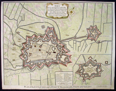
1745 Tindal Original Antique Map of Aire-sur-la-Lys, Fort St Francis & St Venant, France
-
Title : Plan of the City of Aire and Fort of St. Francis with a view of St.Venant
Sep. 28, 1708 - Size: 19 1/2in x 15 1/2in (495mm x 395mm)
- Ref #: 22218
- Date : 1745
- Condition: (A+) Fine Condition
Description:
This beautifully hand coloured original copper-plate engraved antique map, plan & birds eye view of the French city of Aire-sur-la-Lys, a commune in the Pas-de-Calais department in northern France along with Fort St Francis and Fort St Venant - used by Lord Marlborough during the Spanish War of Succession (1701-13) - was engraved by John Basire and was published in the 1745 edition of Nicholas Tindals Continuation of Mr. Rapin\'s History of England.
General Definitions:
Paper thickness and quality: - Heavy and stable
Paper color : - off white
Age of map color: - Early
Colors used: - Pink, blue, green, yellow
General color appearance: - Authentic
Paper size: - 19 1/2in x 15 1/2in (495mm x 395mm)
Plate size: - 19 1/2in x 15 1/2in (495mm x 395mm)
Margins: - Min 1/2in (12mm)
Imperfections:
Margins: - None
Plate area: - Folds as issued
Verso: - None
Background:
Aire-sur-la-Lys is located 10 miles (16 km) southeast of Saint-Omer, by the banks of the Leie and the Laquette rivers.
It is mentioned for the first time in 857 and developed around a fort or castrum built by Baldwin II, Count of Flanders in response to the Norman invasions. More growth followed with the establishment of the Collegiate church of Saint-Pierre by Baldwin V, Count of Flanders.
The town was laid siege ten times between 1127 and 1710. It was separated from the County of Flanders and attached to the County of Artois in 1196. Subsequently ruled by the Burgundians then by the Spanish.
The town was besieged in 1676 by Vauban and retaken for France, although it remained a Spanish possession until 14 April 1713, when, by the Treaty of Utrecht, it finally became a part of France.
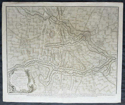
1745 Tindal Original Antique Map Plan of the Battle of Elixheim, Brabant in 1705
- Title : Plan of the Battle lines of Brabant Forced July 18 1705 by the Army of ye Allies commanded by His Grace the Duke of Marlborough & Felt-Marshall D Averquerque Designed upon the spot by Mons D Ivoy Colonel and Quater master General of the Army of the States General
- Size: 19 1/2in x 15 1/2in (495mm x 395mm)
- Ref #: 01-8714
- Date : 1745
- Condition: (A+) Fine Condition
Description:
This original copper-plate engraved antique map, plan of the Battle of Elixheim, in 1705, also known as the Passage of the Lines of Brabant - during the Spanish War of Succession (1701-13) - was engraved by John Basire and was published in the 1745 edition of Nicholas Tindals Continuation of Mr. Rapin\'s History of England.
General Definitions:
Paper thickness and quality: - Heavy and stable
Paper color : - off white
Age of map color: -
Colors used: -
General color appearance: -
Paper size: - 19 1/2in x 15 1/2in (495mm x 395mm)
Plate size: - 19 1/2in x 15 1/2in (495mm x 395mm)
Margins: - Min 1/2in (12mm)
Imperfections:
Margins: - None
Plate area: - None
Verso: - None
Background:
The Battle of Elixheim, 18 July 1705, also known as the Passage of the Lines of Brabant was a battle of the War of the Spanish Succession. The Duke of Marlborough successfully broke through the French Lines of Brabant, an arc of defensive fieldworks stretching in a seventy-mile arc from Antwerp to Namur. Although he was unable to bring about a decisive battle, the breaking and subsequent razing of the lines would prove critical to the allied victory at Ramillies the next year.
Early in the campaigning season, Marlborough attempted to launch an invasion of France up the Moselle valley. This effort was halted by a combination of supply shortages and an excellent French defensive position in front of Sierck, and Marlborough and his army were recalled by the Dutch States General when Marshall Villeroi attacked and took the fortress of Huy and threatened Liege. Having rushed back to the Low Countries (and forcing Villeroi to retreat behind his defenses), Marlborough retook Huy, and then planned to break through the lines to bring Villeroi to battle.
On the evening of 17 July Marlborough sent the Dutch troops under Marshal Overkirk in a feint southwards towards Namur, drawing Villeroi and 40,000 men after them. Overnight he marched with his own English and Scottish troops northwards to the small village of Eliksem (Elixheim), and there broke through the lines without resistance. Early the next day, as Overkirk\'s men countermarched northwards to join with Marlborough, a French detachment attacked the small force of allied troops drawn up to the west of the lines, facing south. Following a short but intense cavalry battle, in which Marlborough was often personally engaged, they were driven off, and Villeroi withdrew his army to the west, behind the river Dyle.
Unable to pursue the French with any vigour on the day of the battle due to the exhaustion of his men, who had marched all night and then fought an intense battle, Marlborough nonetheless still hoped to bring Villeroi to battle. He was frustrated in manoeuvering to the west of the lines in the month immediately following the breakthrough. A final effort in early August, using wagons loaded with supplies to remove his dependency on his lines of communication, while successful in forcing Villeroi\'s army to make a stand close to Waterloo, ultimately failed to bring about a battle due to the veto exercised by the Dutch Field Deputies, notably Slangenburg. The Duke was forced to content himself with the capture of the fortress of Leau and the levelling of the Lines of Brabant between Leau and the Meuse.
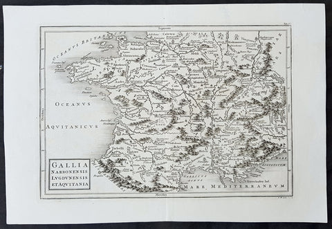
1750 Christop. Cellarius Original Antique Map of France - Gallia
- Title : Gallia Narbonensis Lugdvnensis et Acvitania
- Size: 15in x 10 1/2in (380mm x 265mm)
- Ref #: 31353
- Date : 1750
- Condition: (A+) Fine Condition
Description:
This finely engraved original antique map of France by Christoph. Cellarius was published in the 1750 edition of Geographica Antiqua.
General Definitions:
Paper thickness and quality: - Heavy and stable
Paper color : - off white
Age of map color: -
Colors used: -
General color appearance: -
Paper size: - 15in x 10 1/2in (380mm x 265mm)
Plate size: - 12 1/2in x 8 1/2in (320mm x 215mm)
Margins: - Min 1in (25mm)
Imperfections:
Margins: - None
Plate area: - None
Verso: - None
Background:
Geographica was one of the most popular geographical publications of the 17th and 18th centuries, lasting well into the 19th century. (Ref: Tooley; M&B)
Cellarius, Christopher, 1638-1707
Christopher Cellarius (Keller) was professor of Oriental languages at Halle university and the author of numerous books including his most famous work the atlas Geographica Antiquafirst published in 1686 and being reissued with updated plates until the early 19th century.
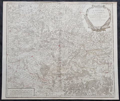
1757 Robert De Vaugondy Large Antique Map The County of Hainaut Belgium & France
- Title : Comte De Hainaut et de Cambres.......Par Le Sr. Robert
- Size: 23in x 19 1/2in (585mm x 495mm)
- Condition: (A+) Fine Condition
- Date : 1757
- Ref #: 41564
Description:
This large magnificent hand coloured original copper-plate engraved antique map of the Hainaut region of Belgium - centering on the city of Mons - by Robert De Vaugondy was published in the 1757 edition of De Vaugondys famous The Atlas Universel
General Definitions:
Paper thickness and quality: - Heavy and stable
Paper color : - off white
Age of map color: - Original & later
Colors used: - Blue, pink, red, green, yellow
General color appearance: - Authentic
Paper size: - 23in x 19 1/2in (585mm x 495mm)
Plate size: - 23in x 19 1/2in (585mm x 495mm)
Margins: - Min 1/4in (6mm)
Imperfections:
Margins: - None
Plate area: - None
Verso: - None
Background:
The County of Hainaut sometimes given the spelling Hainault, was a historical lordship within the medieval Holy Roman Empire with its capital eventually established at Mons (Dutch: Bergen), and named after the river Haine, both now in Belgium. Besides Mons, it included the city of Valenciennes, now in France. It consisted of what is now the Belgian province of Hainaut and the eastern part of the French département of Nord.
Originally a gau of Lotharingia, Hainaut was briefly a part of West Francia (911–25) before becoming definitively attached to Germany. The county was divided in 958 and only emerged in its more or less final form in 1071. Hainaut was culturally and linguistically French. In 1432, Hainaut was acquired by the House of Valois-Burgundy and in 1477 passed to the Habsburgs with the rest of the Burgundian Netherlands and became part of the Burgundian Circle in 1512. It was ruled by the Spanish branch of the Habsburgs from 1555 to 1714. In 1659 and 1678 southern Hainaut was acquired by France, and in 1797 the rest of the county was ceded to France by the Emperor Francis II, who was also count of Hainaut.
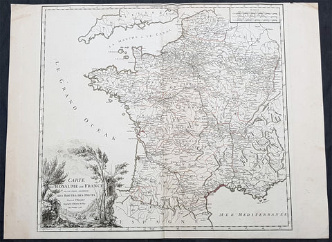
1758 Robert De Vaugondy Large Antique Map of France and Postal Roads
- Title : Carte Du Royame de France ou sont tracees exactement Les Routes Des Postes...1758
- Size: 25 1/2in x 19 1/2in (650mm x 495mm)
- Condition: (A) Very Good Condition
- Date : 1758
- Ref #: 15819
Description:
This large original hand coloured, antique map of France and the postal roads of the day was engraved in 1758 - the date is engraved in the title cartouche - and published by Robert Du Vaugondy in his Atlas Universal, Paris 1757.
General Definitions:
Paper thickness and quality: - Heavy and stable
Paper color : - off white
Age of map color: - Original
Colors used: - Yellow, green, pink
General color appearance: - Authentic
Paper size: - 25 1/2in x 19 1/2in (650mm x 495mm)
Plate size: - 21in x 19 1/2in (535mm x 495mm)
Margins: - Min 1/4in (5mm)
Imperfections:
Margins: - Light age toning
Plate area: - None
Verso: - None
Background:
The Carolingian dynasty ruled France until 987, when Hugh Capet, Duke of France and Count of Paris, was crowned King of the Franks. His descendants—the Capetians, the House of Valois, and the House of Bourbon—progressively unified the country through wars and dynastic inheritance into the Kingdom of France, which was fully declared in 1190 by Philip II Augustus. The French nobility played a prominent role in most Crusades in order to restore Christian access to the Holy Land. French knights made up the bulk of the steady flow of reinforcements throughout the two-hundred-year span of the Crusades, in such a fashion that the Arabs uniformly referred to the crusaders as Franj caring little whether they really came from France. The French Crusaders also imported the French language into the Levant, making French the base of the lingua franca (litt. Frankish language) of the Crusader states. French knights also made up the majority in both the Hospital and the Temple orders. The latter, in particular, held numerous properties throughout France and by the 13th century were the principal bankers for the French crown, until Philip IV annihilated the order in 1307. The Albigensian Crusade was launched in 1209 to eliminate the heretical Cathars in the southwestern area of modern-day France. In the end, the Cathars were exterminated and the autonomous County of Toulouse was annexed into the crown lands of France. Later kings expanded their domain to cover over half of modern continental France, including most of the north, centre and west of France. Meanwhile, the royal authority became more and more assertive, centred on a hierarchically conceived society distinguishing nobility, clergy, and commoners.
From the 11th century, the House of Plantagenet, the rulers of the County of Anjou, succeeded in establishing its dominion over the surrounding provinces of Maine and Touraine, then progressively built an empire that spanned from England to the Pyrenees and covering half of modern France. Tensions between the kingdom of France and the Plantagenet empire would last a hundred years, until Philip Augustus of France conquered between 1202 and 1214 most of the continental possessions of the empire, leaving England and Aquitaine to the Plantagenets. Following the Battle of Bouvines, the Angevin court retreated to England, but persistent Capetian–Plantagenet rivalry would paved the way for another conflict.
Charles IV the Fair died without an heir in 1328. Under the rules of the Salic law the crown of France could not pass to a woman nor could the line of kingship pass through the female line. Accordingly, the crown passed to Philip of Valois, a cousin of Charles, rather than through the female line to Charles nephew, Edward of Plantagenet, who would soon become Edward III of England. During the reign of Philip of Valois, the French monarchy reached the height of its medieval power. Philips seat on the throne was contested by Edward III of England and in 1337, on the eve of the first wave of the Black Death, England and France went to war in what would become known as the Hundred Years War. The exact boundaries changed greatly with time, but French landholdings of the English Kings remained extensive for decades. With charismatic leaders, such as Joan of Arc and La Hire, strong French counterattacks won back English continental territories. Like the rest of Europe, France was struck by the Black Death; half of the 17 million population of France died.
The French Renaissance saw a spectacular cultural development and the first standardisation of the French language, which would become the official language of France and the language of Europes aristocracy. It also saw a long set of wars, known as the Italian Wars, between France and the House of Habsburg. French explorers, such as Jacques Cartier or Samuel de Champlain, claimed lands in the Americas for France, paving the way for the expansion of the First French colonial empire. The rise of Protestantism in Europe led France to a civil war known as the French Wars of Religion, where, in the most notorious incident, thousands of Huguenots were murdered in the St. Bartholomews Day massacre of 1572. The Wars of Religion were ended by Henry IVs Edict of Nantes, which granted some freedom of religion to the Huguenots. Spanish troops, the terror of Western Europe, assisted the Catholic side during the Wars of Religion in 1589–1594, and invaded northern France in 1597; after some skirmishing in the 1620s and 1630s, Spain and France returned to all-out war between 1635 and 1659. The war cost France 300,000 casualties.
Under Louis XIII, the energetic Cardinal Richelieu promoted the centralisation of the state and reinforced the royal power by disarming domestic power holders in the 1620s. He systematically destroyed castles of defiant lords and denounced the use of private violence (dueling, carrying weapons, and maintaining private army). By the end of 1620s, Richelieu established the royal monopoly of force as the doctrine. During Louis XIVs minority and the regency of Queen Anne and Cardinal Mazarin, a period of trouble known as the Fronde occurred in France. This rebellion was driven by the great feudal lords and sovereign courts as a reaction to the rise of royal absolute power in France.
The monarchy reached its peak during the 17th century and the reign of Louis XIV. By turning powerful feudal lords into courtiers at the Palace of Versailles, Louis XIVs personal power became unchallenged. Remembered for his numerous wars, he made France the leading European power. France became the most populous country in Europe and had tremendous influence over European politics, economy, and culture. French became the most-used language in diplomacy, science, literature and international affairs, and remained so until the 20th century. France obtained many overseas possessions in the Americas, Africa and Asia. Louis XIV also revoked the Edict of Nantes, forcing thousands of Huguenots into exile.
Under Louis XV, Louis XIVs great-grandson, France lost New France and most of its Indian possessions after its defeat in the Seven Years War (1756–63). Its European territory kept growing, however, with notable acquisitions such as Lorraine (1766) and Corsica (1770). An unpopular king, Louis XVs weak rule, his ill-advised financial, political and military decisions – as well as the debauchery of his court– discredited the monarchy, which arguably paved the way for the French Revolution 15 years after his death.
Louis XVI, Louis XVs grandson, actively supported the Americans, who were seeking their independence from Great Britain (realised in the Treaty of Paris (1783)). The financial crisis aggravated by Frances involvement in the American Revolutionary War was one of many contributing factors to the French Revolution. Much of the Enlightenment occurred in French intellectual circles, and major scientific breakthroughs and inventions, such as the discovery of oxygen (1778) and the first hot air balloon carrying passengers (1783), were achieved by French scientists. French explorers, such as Bougainville and Lapérouse, took part in the voyages of scientific exploration through maritime expeditions around the globe. The Enlightenment philosophy, in which reason is advocated as the primary source for legitimacy and authority, undermined the power of and support for the monarchy and helped pave the way for the French Revolution.
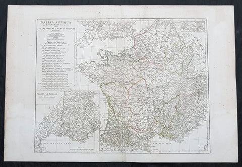
1760 J B D Anville Large Antique Map of Roman France
Antique Map
- Title : Gallia Antiqua ex Aevi Romani......D Anville...MDCCLX
- Size: 30in x 21in (760mm x 535mm)
- Condition: (A) Very Good Condition
- Date : 1760 (dated)
- Ref #: 92296
Description:
This large original copper plate engraved antique map of Roman France was engraved in 1760 - dated in the tile cartouche - and was published in Jean-Baptiste Bourguinon D Anvilles large elephant folio atlas Atlas Generale.
General Definitions:
Paper thickness and quality: - Heavy and stable
Paper color : - off white
Age of map color: - Original
Colors used: - Yellow, Green, pink
General color appearance: - Authentic
Paper size: - 30in x 21in (760mm x 535mm)
Plate size: - 23 1/2in x 18 1/4in (595mm x 465mm)
Margins: - Min 1/2in (12mm)
Imperfections:
Margins: - Creasing, light age toning
Plate area: - Creasing
Verso: - Creasing, light age toning
Background:
In 600 BC, Ionian Greeks, originating from Phocaea, founded the colony of Massalia (present-day Marseille), on the shores of the Mediterranean Sea. This makes it Frances oldest city. At the same time, some Gallic Celtic tribes penetrated parts of the current territory of France, and this occupation spread to the rest of France between the 5th and 3rd century BC.
The concept of Gaul emerged at that time; it corresponds to the territories of Celtic settlement ranging between the Rhine, the Atlantic Ocean, the Pyrenees and the Mediterranean. The borders of modern France are roughly the same as those of ancient Gaul, which was inhabited by Celtic Gauls. Gaul was then a prosperous country, of which the southernmost part was heavily subject to Greek and Roman cultural and economic influences.
Around 390 BC the Gallic chieftain Brennus and his troops made their way to Italy through the Alps, defeated the Romans in the Battle of the Allia, and besieged and ransomed Rome. The Gallic invasion left Rome weakened, and the Gauls continued to harass the region until 345 BC when they entered into a formal peace treaty with Rome. But the Romans and the Gauls would remain adversaries for the next centuries, and the Gauls would continue to be a threat in Italy.
Around 125 BC, the south of Gaul was conquered by the Romans, who called this region Provincia Nostra (Our Province), which over time evolved into the name Provence in French. Julius Caesar conquered the remainder of Gaul and overcame a revolt carried out by the Gallic chieftain Vercingetorix in 52 BC. According to Plutarch and the writings of scholar Brendan Woods, the Gallic Wars resulted in 800 conquered cities, 300 subdued tribes, one million men sold into slavery, and another three million dead in battle.
Gaul was divided by Augustus into Roman provinces. Many cities were founded during the Gallo-Roman period, including Lugdunum (present-day Lyon), which is considered the capital of the Gauls. These cities were built in traditional Roman style, with a forum, a theatre, a circus, an amphitheatre and thermal baths. The Gauls mixed with Roman settlers and eventually adopted Roman culture and Roman speech (Latin, from which the French language evolved). The Roman polytheism merged with the Gallic paganism into the same syncretism.
From the 250s to the 280s AD, Roman Gaul suffered a serious crisis with its fortified borders being attacked on several occasions by barbarians. Nevertheless, the situation improved in the first half of the 4th century, which was a period of revival and prosperity for Roman Gaul. In 312, Emperor Constantin I converted to Christianity. Subsequently, Christians, who had been persecuted until then, increased rapidly across the entire Roman Empire. But, from the beginning of the 5th century, the Barbarian Invasions resumed. Teutonic tribes invaded the region from present-day Germany, the Visigoths settling in the southwest, the Burgundians along the Rhine River Valley, and the Franks (from whom the French take their name) in the north.
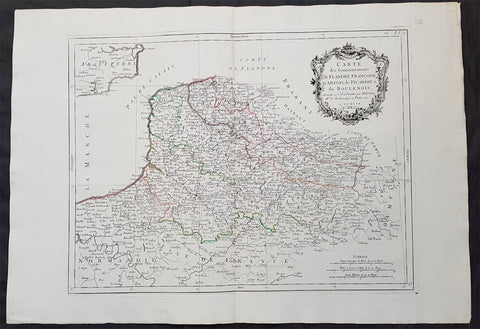
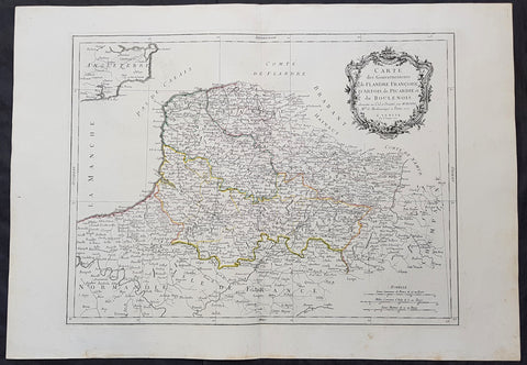
1777 F. Santini Antique Map Flanders Artois Hainaut Picardy Regions of Belgium
- Title : Carte Des Gouvernements de Flandre Francois d Artois de Picardie et du Boulenois...P Santini...1777
- Size: 30in x 21in (760mm x 535mm)
- Condition: (A+) Fine Condition
- Date : 1777
- Ref #: 50221
Description:
This large magnificent original copper-plate engraved antique map of Belgium and parts of Northern France made up of the provinces of Flanders, Artois, Hainaut, Picardy was engraved in 1777 - the date is engraved in the title cartouche - after Rigobert Bonne in 1771 and was published by Francois Santini (active 1776-84) in his 2 volume edition of Atlas Universal 1776-84.. (Ref: Tooley; M&B)
General Definitions:
Paper thickness and quality: - Heavy and stable
Paper color : - off white
Age of map color: - Original
Colors used: - Blue, pink, red, green, yellow
General color appearance: - Authentic
Paper size: - 30in x 21in (760mm x 535mm)
Plate size: - 23in x 18in (585mm x 460mm)
Margins: - Min 2in (50mm)
Imperfections:
Margins: - None
Plate area: - None
Verso: - None
Background:
Belgium officially the Kingdom of Belgium, is a country in Western Europe bordered by France, the Netherlands, Germany and Luxembourg.
Historically, Belgium was part of an area known as the Low Countries, a somewhat larger region than the current Benelux group of states that also included parts of northern France and western Germany. Its name is derived from the Latin word Belgica, after the Roman province of Gallia Belgica. From the end of the Middle Ages until the 17th century, the area of Belgium was a prosperous and cosmopolitan centre of commerce and culture. Between the 16th and early 19th centuries, Belgium served as the battleground between many European powers, earning the moniker the Battlefield of Europe, a reputation strengthened by both world wars. The country emerged in 1830 following the Belgian Revolution when it seceded from the Netherlands.
The Eighty Years War (1568–1648) divided the Low Countries into the northern United Provinces (Belgica Foederata in Latin, the Federated Netherlands) and the Southern Netherlands (Belgica Regia, the Royal Netherlands). The latter were ruled successively by the Spanish (Spanish Netherlands) and the Austrian Habsburgs (Austrian Netherlands) and comprised most of modern Belgium. This was the theatre of most Franco-Spanish and Franco-Austrian wars during the 17th and 18th centuries.
Following the campaigns of 1794 in the French Revolutionary Wars, the Low Countries—including territories that were never nominally under Habsburg rule, such as the Prince-Bishopric of Liège—were annexed by the French First Republic, ending Austrian rule in the region. The reunification of the Low Countries as the United Kingdom of the Netherlands occurred at the dissolution of the First French Empire in 1815, after the defeat of Napoleon.
1777 F. Santini Antique Map Flanders Artois Hainaut Picardy Regions of Belgium
- Title : Carte Des Gouvernements de Flandre Francois d Artois de Picardie et du Boulenois...P Santini...1777
- Size: 30in x 21in (760mm x 535mm)
- Condition: (A+) Fine Condition
- Date : 1777
- Ref #: 50219
Description:
This large magnificent original copper-plate engraved antique map of Belgium and parts of Northern France made up of the provinces of Flanders, Artois, Hainaut, Picardy was engraved in 1777 - the date is engraved in the title cartouche - after Rigobert Bonne in 1771 and was published by Francois Santini (active 1776-84) in his 2 volume edition of Atlas Universal 1776-84.. (Ref: Tooley; M&B)
General Definitions:
Paper thickness and quality: - Heavy and stable
Paper color : - off white
Age of map color: - Original
Colors used: - Blue, pink, red, green, yellow
General color appearance: - Authentic
Paper size: - 30in x 21in (760mm x 535mm)
Plate size: - 23in x 18in (585mm x 460mm)
Margins: - Min 2in (50mm)
Imperfections:
Margins: - None
Plate area: - None
Verso: - None
Background:
Belgium officially the Kingdom of Belgium, is a country in Western Europe bordered by France, the Netherlands, Germany and Luxembourg.
Historically, Belgium was part of an area known as the Low Countries, a somewhat larger region than the current Benelux group of states that also included parts of northern France and western Germany. Its name is derived from the Latin word Belgica, after the Roman province of Gallia Belgica. From the end of the Middle Ages until the 17th century, the area of Belgium was a prosperous and cosmopolitan centre of commerce and culture. Between the 16th and early 19th centuries, Belgium served as the battleground between many European powers, earning the moniker the Battlefield of Europe, a reputation strengthened by both world wars. The country emerged in 1830 following the Belgian Revolution when it seceded from the Netherlands.
The Eighty Years War (1568–1648) divided the Low Countries into the northern United Provinces (Belgica Foederata in Latin, the Federated Netherlands) and the Southern Netherlands (Belgica Regia, the Royal Netherlands). The latter were ruled successively by the Spanish (Spanish Netherlands) and the Austrian Habsburgs (Austrian Netherlands) and comprised most of modern Belgium. This was the theatre of most Franco-Spanish and Franco-Austrian wars during the 17th and 18th centuries.
Following the campaigns of 1794 in the French Revolutionary Wars, the Low Countries—including territories that were never nominally under Habsburg rule, such as the Prince-Bishopric of Liège—were annexed by the French First Republic, ending Austrian rule in the region. The reunification of the Low Countries as the United Kingdom of the Netherlands occurred at the dissolution of the First French Empire in 1815, after the defeat of Napoleon.
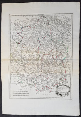
1777 Santini Antique Map French Provinces, Bourges Nevers Guéret Moulins Limoges
- Title : Carte Des Gouvernements du Berri, du Nivernois, de la Marche, du Bourbonnois, du Limosim et de L Auvergne...Par M Bonne 1771....A Venise...P Santini...1777
- Date : 1777
- Condition: (A+) Fine Condition
- Ref: 50197
- Size: 30in x 21in (760mm x 535mm)
Description:
This large magnificent original copper-plate engraved antique map of French Provinces of Berry (Bourges) Nivernais (Nevers) Marche (Guéret) Bourbonnais (Moulins) Limousin (Limoges) & Auvergne (Clermont-Ferrand) was engraved in 1777 - the date is engraved in the title cartouche - after Robert Bonne and was published by Francois Santini (active 1776-84) in his 2 volume edition of Atlas Universal 1776-84. (Ref: Tooley; M&B)
General Definitions:
Paper thickness and quality: - Heavy and stable
Paper color : - off white
Age of map color: - Original
Colors used: - Blue, pink, red, green, yellow
General color appearance: - Authentic
Paper size: - 30in x 21in (760mm x 535mm)
Plate size: - 23in x 17in (595mm x 430mm)
Margins: - Min 1in (25mm)
Imperfections:
Margins: - None
Plate area: - None
Verso: - Light age toning
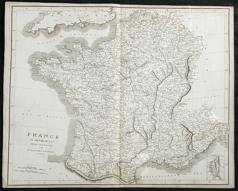
1814 Dr Playfairs Large Antique Map of France in Departments
Antique Map
- Title : France in Departments Drawn and Engraved for Dr Playfairs Geography.
- Size: 23in x 18 1/2in (585mm x 480mm)
- Condition: (A) Very Good Condition
- Date : 1814
- Ref #: 31154
Description:
This large original antique copper-plate engraved map of France was published in the 1814 edition of A System of Geography Ancient and Modern (1810–14) (Ref Tooley M&B)
General Definitions:
Paper thickness and quality: - Heavy and stable
Paper color : - off white
Age of map color: -
Colors used: -
General color appearance: -
Paper size: - 23in x 18 1/2in (585mm x 480mm)
Plate size: - 23in x 18 1/2in (585mm x 480mm)
Margins: - Min 1/2in (10mm)
Imperfections:
Margins: - Light age toning in margins
Plate area: - None
Verso: - Light age toning
Playfair, Rev James Octavius 1738 - 1819
Rev Playfair was a Scottish minister and author and an eminent figure in the Scottish Enlightenment. He was born at West Bendochy in Perthshire the son of George Playfair (d. 1786), a farmer, and his wife, Jean Roger (d. 1804).[1]
He studied at St Andrews University and then became minister of Newtyle (1770–77) and Meigle (1777–1800). He was then appointed Principal of St Andrews University in 1800. During this period he was also minister of St Leonard\\\'s Church in St Andrews.
In 1779 St Andrews awarded him an honorary doctorate (DD). In 1787 he was elected a Fellow of the Royal Society of Edinburgh. His proposers were John Playfair (a distant cousin) and Alexander Fraser Tytler.[2]
He was the official histiographer of the then Prince of Wales.
He died at Dalmarnock near Glasgow. He is buried in Glasgow but is also memorialised on the grave of his wife in the churchyard of St Andrews Cathedral.
Publications:
1. A System of Chronology (1782)
2. A System of Geography Ancient and Modern (1810–14)
3. General Atlas Ancient and Modern (1814)
4. A Geographical and Statistical Description of Scotland (1819)
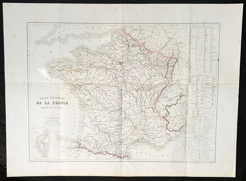
1846 Louis Dussieux Large Antique Map of The Political Boundaries of France
- Title : 1846 Louis Dussieux Large Antique Map of The Political Boundaries of France
- Size: 27 1/2in x 20 1/2in (700mm x 520mm)
- Condition: (A+) Fine Condition
- Date : 1846
- Ref #: 32414
Description:
This large hand coloured original copper plate engraved antique map was published by Louis Dussieux in the 1846 edition of Atlas Generale
General Definitions:
Paper thickness and quality: - Heavy and stable
Paper color : - off white
Age of map color: - Original
Colors used: - Pink
General color appearance: - Authentic
Paper size: - 27 1/2in x 20 1/2in (700mm x 520mm)
Plate size: - 27 1/2in x 20 1/2in (700mm x 520mm)
Margins: - Min 1in (25mm)
Imperfections:
Margins: - Folds as issued
Plate area: - Folds as issued
Verso: - Folds as issued
Dussieux, Louis 1815 - 1894
Dussieux was a French Geographer, prolific during the mid 19th century. After winning prizes in competitions of the Academy of Inscriptions and Belles Letters in 1839 and 1840, he was appointed recorder of military history and geography at the Saint - Cyr Special School in 1842 and became the professor of history in 1850. In 1843 he was appointed correspondent for the Historical Monuments Committee.
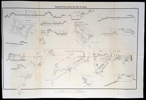
1856 Capt Delafield Large Antique Schematics Forts City of Lyons, France
Antique Map
- Title : Detached Forts about the City of Lyons
- Date : 1856
- Condition: (A) Very Good Condition
- Ref: 90193
- Size: 29in x 20in (735mm x 515mm)
This large original lithograph print, schematics of the forts or Belts of Lyon, France - during the time of the Crimean War and just prior to the American Civil War - was engraved by John T Bowen & co. of Philadelphia and was published in the 1856 edition of Captain Richard Delafields Report on the Art of War in Europe in 1854, 1855, and 1856.
In early 1855, Captain Richard Delafield was appointed by the Secretary of War, Jefferson Davis, a head of the board of officers, later called The Delafield Commission, and sent to Europe to study the European military. The board included Captain George B. McClellan and Major Alfred Mordecai. They inspected the state of the military in Great Britain, Germany, the Austrian Empire, France, Belgium, and Russia, and served as military observers during the Crimean War. After his return in April 1856, Delafield submitted a report which was later published as a book by Congress, Report on the Art of War in Europe in 1854, 1855, and 1856. The book was suppressed during the American Civil War due to fears that it would be instructive to Confederate engineers as it contained multiple drawings and descriptions of military fortifications.
General Definitions:
Paper thickness and quality: - Light and stable
Paper color : - off white
Age of map color: -
Colors used: -
General color appearance: -
Paper size: - 29in x 20in (735mm x 515mm)
Plate size: - 29in x 20in (735mm x 515mm)
Margins: - Min 1/2in (12mm)
Imperfections:
Margins: - None
Plate area: - Folds as issued
Verso: - Folds re-enforced with archival tape
Background:
The ceintures de Lyon (Belts of Lyon) were a series of fortifications built between 1830 and 1890 around the city of Lyon, France to protect the city from foreign invasion.
The belts comprised two defensive barriers that included forts, lunettes, ramparts, batteries, and other defensive structures. Many of these structures proved to be ineffective in war due to advancement in weapon technology and the evolution of attack strategies at the time. Some of the fortifications of the ceintures de Lyon have been destroyed, though many remain today.
In 1830 the maréchal de camp, Hubert Rohault de Fleury, commenced a project designed by military engineer Baron Haxo. With a budget of 10,000,000 francs (approximately €67,000,000 as of 2015) allocated for Lyon between 1831 and 1839, this first project included the restoration of the fortifications between Croix Rousse and Fourvière; the construction of two forts on the plateau of Caluire (Fort de Montessuy and Fort de Caluire, connected by the Enceinte de Caluire), facing the Dombes; closing access to the Presquîle by the construction of a south-facing building; building two forts – Fort de la Duchère and Fort de Grange Blanche – to protect access routes towards Paris and Auvergne.
The fortification of the city is divided into three sectors: The north was protected by the wall of Croix-Rousse and the structures between the Rhône and the Saône. The command was situated at fort de Montessuy. The west was covered by the hillfort of Fourvière and the associated forts of Vaise at Sainte-Foy. The command was situated at fort Saint-Irénée. The east was defended by the Redoute du Haut-Rhône and Fort de la Vitriolerie on the left bank of the Rhône. The command was situated at Fort Lamothe.
The work required almost 20,000 workers, which were locally sourced in an attempt to avoid insurrection such as the ongoing unrest of the Lyon silk workers (Canuts) over increased capitalism. Work began in 1831 to build seven structures, each structure requiring between 400 and 500 workers. The scope of this project included the construction of Fort de Montessuy and Fort de Caluire to the north; Fort des Brotteaux, Fort Montluc and Fort du Colombier to the east; the Redoute de la Part-Dieu to the west; and Fort Saint-Irénée, to protect the entire area.
In January 1831, an uprising began at a work site in Charpennes, however it was quickly stopped by the army. Other insurrections took place the same year, a series of Canut revolts, which succeeded in rallying soldiers on the side of the Canuts, resulting in the death of captain Viquesnel, aide-de-camp of Fleury, and the temporary withdrawal of the 20,000 soldiers who eventually retook the city in December 1831.
In 1832, three other structures were built to reinforce the defenses to the east: The Redoute de la Tête dor, Fort La Motte, and the Redoute des Hirondelles. A treaty was signed between the city of Lyon and the War Department, which stipulated that the city had to cede the land necessary for the construction of military buildings to the War Department, while the forts themselves would still belong to the city if the military decided to abandon them. It is thanks to this treaty that the forts of Croix Rousse, Fourvière, Loyasse, Vaise, and Saint-Jean would later be returned to the city.
Construction resumed in 1840. First the Fort de la Vitriolerie in 1840, then Fort de Sainte-Foy-lès-Lyon and the Lunette des Charpennes in 1842, Fort de la Duchère in 1844, the Redoute du Petit Sainte-Foy-lès-Lyon in 1852, and finally the Redoute du haut-Rhône in 1854.
A law was voted in on 10 July 1851, which defined the methods of destruction of these buildings or construction on their land. By 1854, 19 structures including 10 forts had been built around Lyon, creating a nearly 14-kilometre (8.7 mi) fortified perimeter.
Delafield, Richard Major General 1798 - 1873
Delafield was a United States Army officer for 52 years. He served as superintendent of the United States Military Academy for 12 years. At the start of the American Civil War, then Colonel Delafield helped equip and send volunteers from New York to the Union Army. He also was in command of defences around New York harbor from 1861 to April 1864. On April 22, 1864, he was promoted to Brigadier General in the Regular Army of the United States and Chief of Engineers. On March 8, 1866, President Andrew Johnson nominated Delafield for appointment to the grade of brevet major general in the Regular Army, to rank from March 13, 1865, and the United States Senate confirmed the appointment on May 4, 1866, reconfirmed due to a technicality on July 14, 1866. He retired from the US Army on August 8, 1866. He later served on two commissions relating to improvements to Boston Harbor and to lighthouses. He also served as a regent of the Smithsonian Institution.
Delafield served as assistant engineer in the construction of Hampton Roads defences from 1819–1824 and was in charge of fortifications and surveys in the Mississippi River delta area in 1824-1832. While superintendent of repair work on the Cumberland Road east of the Ohio River, he designed and built Dunlaps Creek Bridge in Brownsville, Pennsylvania, the first cast-iron tubular-arch bridge in the United States. Commissioned a major of engineers in July 1838, he was appointed superintendent of the Military Academy after the fire of 1838 and served till 1845. He designed the new buildings and the new cadet uniform that first displayed the castle insignia. He superintended the construction of coast defences for New York Harbor from 1846 to 1855.
In the beginning of 1855, Delafield was appointed by the Secretary of War, Jefferson Davis a head of the board of officers, later called The Delafield Commission, and sent to Europe to study the European military. The board included Captain George B. McClellan and Major Alfred Mordecai. They inspected the state of the military in Great Britain, Germany, the Austrian Empire, France, Belgium, and Russia, and served as military observers during the Crimean War. After his return in April 1856, Delafield submitted a report which was later published as a book by Congress, Report on the Art of War in Europe in 1854, 1855, and 1856. The book was suppressed during the American Civil War due to fears that it would be instructive to Confederate engineers as it contained multiple drawings and descriptions of military fortifications.
Delafield served as superintendent of the Military Academy again in 1856-1861. In January 1861, he was succeeded by Captain Pierre G. T. Beauregard, who was dismissed shortly after Beauregards home state of Louisiana seceded from the Union, and Delafield returned as superintendent serving until March 1, 1861. In the beginning of the Civil War he advised the governor of New York Edwin D. Morgan during the volunteer force creation. Then, in 1861–1864, he was put in charge of New York Harbor defences, including Governors Island and Fort at Sandy Hook. On May 19, 1864, he was commissioned a brigadier-general after replacing Joseph Gilbert Totten, who had died, as the Chief of Engineers, United States Army Corps of Engineers, on April 22, 1864. He stayed in charge of the Bureau of Engineers of the War Department until his retirement on August 8, 1866. On March 8, 1866, President Andrew Johnson nominated Delafield for appointment to the grade of brevet major general in the Regular Army of the United States, to rank from March 13, 1865, and the United States Senate confirmed the appointment on May 4, 1866 and reconfirmed it due to a technicality on July 14, 1866.After retirement Delafield served as a regent of the Smithsonian Institution and a member of the Lighthouse Board. He died in Washington, D.C. on November 5, 1873.
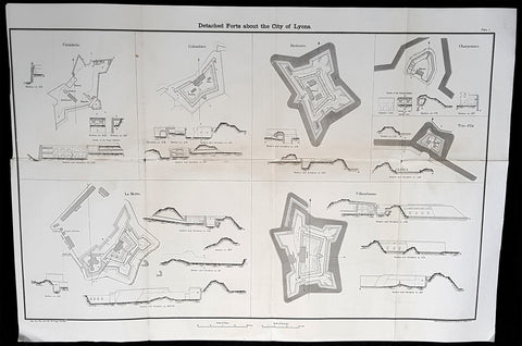
1856 Capt Delafield Large Antique Schematics Forts City of Lyons, France
Antique Map
- Title : Detached Forts about the City of Lyons
- Date : 1856
- Condition: (A) Very Good Condition
- Ref: 90123
- Size: 29in x 20in (735mm x 515mm)
Description:
This large original lithograph print, schematics of various forts in and around the French city of Lyons - during the time of the Crimean War and just prior to the American Civil War - was engraved by John T Bowen & co. of Philadelphia and was published in the 1856 edition of Captain Richard Delafields Report on the Art of War in Europe in 1854, 1855, and 1856.
In early 1855, Captain Richard Delafield was appointed by the Secretary of War, Jefferson Davis, a head of the board of officers, later called The Delafield Commission, and sent to Europe to study the European military. The board included Captain George B. McClellan and Major Alfred Mordecai. They inspected the state of the military in Great Britain, Germany, the Austrian Empire, France, Belgium, and Russia, and served as military observers during the Crimean War. After his return in April 1856, Delafield submitted a report which was later published as a book by Congress, Report on the Art of War in Europe in 1854, 1855, and 1856. The book was suppressed during the American Civil War due to fears that it would be instructive to Confederate engineers as it contained multiple drawings and descriptions of military fortifications.
General Definitions:
Paper thickness and quality: - Light and stable
Paper color : - off white
Age of map color: -
Colors used: -
General color appearance: -
Paper size: - 29in x 20in (735mm x 515mm)
Plate size: - 29in x 20in (735mm x 515mm)
Margins: - Min 1/2in (12mm)
Imperfections:
Margins: - None
Plate area: - Folds as issued
Verso: - Folds re-enforced with archival tape
Background:
The ceintures de Lyon (Belts of Lyon) were a series of fortifications built between 1830 and 1890 around the city of Lyon, France to protect the city from foreign invasion.
The belts comprised two defensive barriers that included forts, lunettes, ramparts, batteries, and other defensive structures. Many of these structures proved to be ineffective in war due to advancement in weapon technology and the evolution of attack strategies at the time. Some of the fortifications of the ceintures de Lyon have been destroyed, though many remain today.
In 1830 the maréchal de camp, Hubert Rohault de Fleury, commenced a project designed by military engineer Baron Haxo. With a budget of 10,000,000 francs (approximately €67,000,000 as of 2015) allocated for Lyon between 1831 and 1839, this first project included the restoration of the fortifications between Croix Rousse and Fourvière; the construction of two forts on the plateau of Caluire (Fort de Montessuy and Fort de Caluire, connected by the Enceinte de Caluire), facing the Dombes; closing access to the Presquîle by the construction of a south-facing building; building two forts – Fort de la Duchère and Fort de Grange Blanche – to protect access routes towards Paris and Auvergne.
The fortification of the city is divided into three sectors: The north was protected by the wall of Croix-Rousse and the structures between the Rhône and the Saône. The command was situated at fort de Montessuy. The west was covered by the hillfort of Fourvière and the associated forts of Vaise at Sainte-Foy. The command was situated at fort Saint-Irénée. The east was defended by the Redoute du Haut-Rhône and Fort de la Vitriolerie on the left bank of the Rhône. The command was situated at Fort Lamothe.
The work required almost 20,000 workers, which were locally sourced in an attempt to avoid insurrection such as the ongoing unrest of the Lyon silk workers (Canuts) over increased capitalism. Work began in 1831 to build seven structures, each structure requiring between 400 and 500 workers. The scope of this project included the construction of Fort de Montessuy and Fort de Caluire to the north; Fort des Brotteaux, Fort Montluc and Fort du Colombier to the east; the Redoute de la Part-Dieu to the west; and Fort Saint-Irénée, to protect the entire area.
In January 1831, an uprising began at a work site in Charpennes, however it was quickly stopped by the army. Other insurrections took place the same year, a series of Canut revolts, which succeeded in rallying soldiers on the side of the Canuts, resulting in the death of captain Viquesnel, aide-de-camp of Fleury, and the temporary withdrawal of the 20,000 soldiers who eventually retook the city in December 1831.
In 1832, three other structures were built to reinforce the defenses to the east: The Redoute de la Tête dor, Fort La Motte, and the Redoute des Hirondelles. A treaty was signed between the city of Lyon and the War Department, which stipulated that the city had to cede the land necessary for the construction of military buildings to the War Department, while the forts themselves would still belong to the city if the military decided to abandon them. It is thanks to this treaty that the forts of Croix Rousse, Fourvière, Loyasse, Vaise, and Saint-Jean would later be returned to the city.
Construction resumed in 1840. First the Fort de la Vitriolerie in 1840, then Fort de Sainte-Foy-lès-Lyon and the Lunette des Charpennes in 1842, Fort de la Duchère in 1844, the Redoute du Petit Sainte-Foy-lès-Lyon in 1852, and finally the Redoute du haut-Rhône in 1854.
A law was voted in on 10 July 1851, which defined the methods of destruction of these buildings or construction on their land. By 1854, 19 structures including 10 forts had been built around Lyon, creating a nearly 14-kilometre (8.7 mi) fortified perimeter.
Delafield, Richard Major General 1798 - 1873 - Delafield was a United States Army officer for 52 years. He served as superintendent of the United States Military Academy for 12 years. At the start of the American Civil War, then Colonel Delafield helped equip and send volunteers from New York to the Union Army. He also was in command of defences around New York harbor from 1861 to April 1864. On April 22, 1864, he was promoted to Brigadier General in the Regular Army of the United States and Chief of Engineers. On March 8, 1866, President Andrew Johnson nominated Delafield for appointment to the grade of brevet major general in the Regular Army, to rank from March 13, 1865, and the United States Senate confirmed the appointment on May 4, 1866, reconfirmed due to a technicality on July 14, 1866. He retired from the US Army on August 8, 1866. He later served on two commissions relating to improvements to Boston Harbor and to lighthouses. He also served as a regent of the Smithsonian Institution.
Delafield served as assistant engineer in the construction of Hampton Roads defences from 1819–1824 and was in charge of fortifications and surveys in the Mississippi River delta area in 1824-1832. While superintendent of repair work on the Cumberland Road east of the Ohio River, he designed and built Dunlaps Creek Bridge in Brownsville, Pennsylvania, the first cast-iron tubular-arch bridge in the United States. Commissioned a major of engineers in July 1838, he was appointed superintendent of the Military Academy after the fire of 1838 and served till 1845. He designed the new buildings and the new cadet uniform that first displayed the castle insignia. He superintended the construction of coast defences for New York Harbor from 1846 to 1855.
In the beginning of 1855, Delafield was appointed by the Secretary of War, Jefferson Davis a head of the board of officers, later called The Delafield Commission, and sent to Europe to study the European military. The board included Captain George B. McClellan and Major Alfred Mordecai. They inspected the state of the military in Great Britain, Germany, the Austrian Empire, France, Belgium, and Russia, and served as military observers during the Crimean War. After his return in April 1856, Delafield submitted a report which was later published as a book by Congress, Report on the Art of War in Europe in 1854, 1855, and 1856. The book was suppressed during the American Civil War due to fears that it would be instructive to Confederate engineers as it contained multiple drawings and descriptions of military fortifications.
Delafield served as superintendent of the Military Academy again in 1856-1861. In January 1861, he was succeeded by Captain Pierre G. T. Beauregard, who was dismissed shortly after Beauregards home state of Louisiana seceded from the Union, and Delafield returned as superintendent serving until March 1, 1861. In the beginning of the Civil War he advised the governor of New York Edwin D. Morgan during the volunteer force creation. Then, in 1861–1864, he was put in charge of New York Harbor defences, including Governors Island and Fort at Sandy Hook. On May 19, 1864, he was commissioned a brigadier-general after replacing Joseph Gilbert Totten, who had died, as the Chief of Engineers, United States Army Corps of Engineers, on April 22, 1864. He stayed in charge of the Bureau of Engineers of the War Department until his retirement on August 8, 1866. On March 8, 1866, President Andrew Johnson nominated Delafield for appointment to the grade of brevet major general in the Regular Army of the United States, to rank from March 13, 1865, and the United States Senate confirmed the appointment on May 4, 1866 and reconfirmed it due to a technicality on July 14, 1866.After retirement Delafield served as a regent of the Smithsonian Institution and a member of the Lighthouse Board. He died in Washington, D.C. on November 5, 1873.
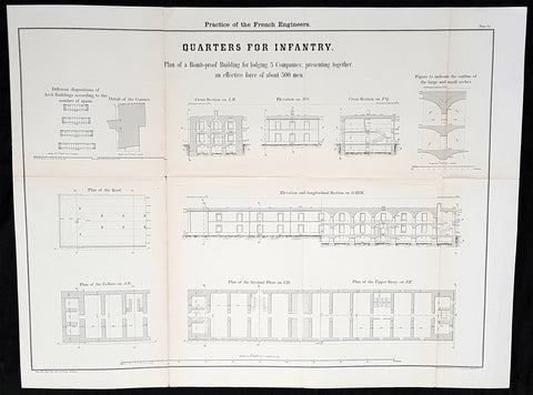
1856 Capt Delafield Large Antique Schematics French Infantry Barracks & Quarters
Antique Map
- Title : Theory and Practice of the French Engineers....Quaters for Infantry..Plan of the Bob Proof Building for lodging 5 Companies presenting together an effective force of about 500 men.
- Date : 1856
- Condition: (A+) Fine Condition
- Ref: 90126
- Size: 26in x 20in (660mm x 500mm)
Description:
This large original lithograph print, schematics of barracks and quarters for infantry in France - during the time of the Crimean War and just prior to the American Civil War - was engraved by John T Bowen & co. of Philadelphia and was published in the 1856 edition of Captain Richard Delafields Report on the Art of War in Europe in 1854, 1855, and 1856.
In early 1855, Captain Richard Delafield was appointed by the Secretary of War, Jefferson Davis, a head of the board of officers, later called The Delafield Commission, and sent to Europe to study the European military. The board included Captain George B. McClellan and Major Alfred Mordecai. They inspected the state of the military in Great Britain, Germany, the Austrian Empire, France, Belgium, and Russia, and served as military observers during the Crimean War. After his return in April 1856, Delafield submitted a report which was later published as a book by Congress, Report on the Art of War in Europe in 1854, 1855, and 1856. The book was suppressed during the American Civil War due to fears that it would be instructive to Confederate engineers as it contained multiple drawings and descriptions of military fortifications.
General Definitions:
Paper thickness and quality: - Light and stable
Paper color : - off white
Age of map color: -
Colors used: -
General color appearance: -
Paper size: - 26in x 20in (660mm x 500mm)
Plate size: - 26in x 20in (660mm x 500mm)
Margins: - Min 1/2in (12mm)
Imperfections:
Margins: - None
Plate area: - Folds as issued
Verso: - Folds re-enforced with archival tape
Background:
The arrival of explosive shells in the 19th century led to yet another stage in the evolution of fortification. Star forts did not fare well against the effects of high explosive and the intricate arrangements of bastions, flanking batteries and the carefully constructed lines of fire for the defending cannon could be rapidly disrupted by explosive shells.
Worse, the large open ditches surrounding forts of this type were an integral part of the defensive scheme, as was the covered way at the edge of the counter scarp. The ditch was extremely vulnerable to bombardment with explosive shells.
In response, military engineers evolved the polygonal style of fortification. The ditch became deep and vertically sided, cut directly into the native rock or soil, laid out as a series of straight lines creating the central fortified area that gives this style of fortification its name.
Wide enough to be an impassable barrier for attacking troops, but narrow enough to be a difficult target for enemy shellfire, the ditch was swept by fire from defensive blockhouses set in the ditch as well as firing positions cut into the outer face of the ditch itself.
The profile of the fort became very low indeed, surrounded outside the ditch covered by caponiers by a gently sloping open area so as to eliminate possible cover for enemy forces, while the fort itself provided a minimal target for enemy fire. The entrypoint became a sunken gatehouse in the inner face of the ditch, reached by a curving ramp that gave access to the gate via a rolling bridge that could be withdrawn into the gatehouse.
Much of the fort moved underground. Deep passages and tunnels now connected the blockhouses and firing points in the ditch to the fort proper, with magazines and machine rooms deep under the surface. The guns, however, were often mounted in open emplacements and protected only by a parapet; both in order to keep a lower profile and also because experience with guns in closed casemates had seen them put out of action by rubble as their own casemates were collapsed around them.
Gone were citadels surrounding towns: forts were to be moved to the outside of the cities some 12 km to keep the enemy at a distance so their artillery could not bombard the city center. From now on a ring of forts were to be built at a spacing that would allow them to effectively cover the intervals between them.
The new forts abandoned the principle of the bastion, which had also been made obsolete by advances in arms. The outline was a much simplified polygon, surrounded by a ditch. These forts, built in masonry and shaped stone, were designed to shelter their garrison against bombardment. One organizing feature of the new system involved the construction of two defensive curtains: an outer line of forts, backed by an inner ring or line at critical points of terrain or junctions (see, for example, Séré de Rivières system in France).
Traditional fortification however continued to be applied by European armies engaged in warfare in colonies established in Africa against lightly armed attackers from amongst the indigenous population. A relatively small number of defenders in a fort impervious to primitive weaponry could hold out against high odds, the only constraint being the supply of ammunition.
Delafield, Richard Major General 1798 - 1873 - Delafield was a United States Army officer for 52 years. He served as superintendent of the United States Military Academy for 12 years. At the start of the American Civil War, then Colonel Delafield helped equip and send volunteers from New York to the Union Army. He also was in command of defences around New York harbor from 1861 to April 1864. On April 22, 1864, he was promoted to Brigadier General in the Regular Army of the United States and Chief of Engineers. On March 8, 1866, President Andrew Johnson nominated Delafield for appointment to the grade of brevet major general in the Regular Army, to rank from March 13, 1865, and the United States Senate confirmed the appointment on May 4, 1866, reconfirmed due to a technicality on July 14, 1866. He retired from the US Army on August 8, 1866. He later served on two commissions relating to improvements to Boston Harbor and to lighthouses. He also served as a regent of the Smithsonian Institution.
Delafield served as assistant engineer in the construction of Hampton Roads defences from 1819–1824 and was in charge of fortifications and surveys in the Mississippi River delta area in 1824-1832. While superintendent of repair work on the Cumberland Road east of the Ohio River, he designed and built Dunlaps Creek Bridge in Brownsville, Pennsylvania, the first cast-iron tubular-arch bridge in the United States. Commissioned a major of engineers in July 1838, he was appointed superintendent of the Military Academy after the fire of 1838 and served till 1845. He designed the new buildings and the new cadet uniform that first displayed the castle insignia. He superintended the construction of coast defences for New York Harbor from 1846 to 1855.
In the beginning of 1855, Delafield was appointed by the Secretary of War, Jefferson Davis a head of the board of officers, later called The Delafield Commission, and sent to Europe to study the European military. The board included Captain George B. McClellan and Major Alfred Mordecai. They inspected the state of the military in Great Britain, Germany, the Austrian Empire, France, Belgium, and Russia, and served as military observers during the Crimean War. After his return in April 1856, Delafield submitted a report which was later published as a book by Congress, Report on the Art of War in Europe in 1854, 1855, and 1856. The book was suppressed during the American Civil War due to fears that it would be instructive to Confederate engineers as it contained multiple drawings and descriptions of military fortifications.
Delafield served as superintendent of the Military Academy again in 1856-1861. In January 1861, he was succeeded by Captain Pierre G. T. Beauregard, who was dismissed shortly after Beauregards home state of Louisiana seceded from the Union, and Delafield returned as superintendent serving until March 1, 1861. In the beginning of the Civil War he advised the governor of New York Edwin D. Morgan during the volunteer force creation. Then, in 1861–1864, he was put in charge of New York Harbor defences, including Governors Island and Fort at Sandy Hook. On May 19, 1864, he was commissioned a brigadier-general after replacing Joseph Gilbert Totten, who had died, as the Chief of Engineers, United States Army Corps of Engineers, on April 22, 1864. He stayed in charge of the Bureau of Engineers of the War Department until his retirement on August 8, 1866. On March 8, 1866, President Andrew Johnson nominated Delafield for appointment to the grade of brevet major general in the Regular Army of the United States, to rank from March 13, 1865, and the United States Senate confirmed the appointment on May 4, 1866 and reconfirmed it due to a technicality on July 14, 1866.After retirement Delafield served as a regent of the Smithsonian Institution and a member of the Lighthouse Board. He died in Washington, D.C. on November 5, 1873.
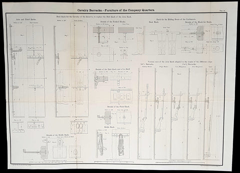
1856 Capt Delafield Large Antique Schematics of Calvary Barracks Rifles, Pistols
Antique Map
- Title : Cavalry Barracks - Furniture of the Company Quarters...
- Date : 1856
- Condition: (A+) Fine Condition
- Ref: 90133
- Size: 26in x 20in (660mm x 500mm)
Description:
This large original lithograph print, schematics of the internals of cavalry barracks and quarters (guns, boots, pistols etc) - during the time of the Crimean War and just prior to the American Civil War - was engraved by John T Bowen & co. of Philadelphia and was published in the 1856 edition of Captain Richard Delafields Report on the Art of War in Europe in 1854, 1855, and 1856.
In early 1855, Captain Richard Delafield was appointed by the Secretary of War, Jefferson Davis, a head of the board of officers, later called The Delafield Commission, and sent to Europe to study the European military. The board included Captain George B. McClellan and Major Alfred Mordecai. They inspected the state of the military in Great Britain, Germany, the Austrian Empire, France, Belgium, and Russia, and served as military observers during the Crimean War. After his return in April 1856, Delafield submitted a report which was later published as a book by Congress, Report on the Art of War in Europe in 1854, 1855, and 1856. The book was suppressed during the American Civil War due to fears that it would be instructive to Confederate engineers as it contained multiple drawings and descriptions of military fortifications.
General Definitions:
Paper thickness and quality: - Light and stable
Paper color : - off white
Age of map color: -
Colors used: -
General color appearance: -
Paper size: - 26in x 20in (660mm x 500mm)
Plate size: - 26in x 20in (660mm x 500mm)
Margins: - Min 1/2in (12mm)
Imperfections:
Margins: - None
Plate area: - Folds as issued
Verso: - Folds re-enforced with archival tape
Background:
The arrival of explosive shells in the 19th century led to yet another stage in the evolution of fortification. Star forts did not fare well against the effects of high explosive and the intricate arrangements of bastions, flanking batteries and the carefully constructed lines of fire for the defending cannon could be rapidly disrupted by explosive shells.
Worse, the large open ditches surrounding forts of this type were an integral part of the defensive scheme, as was the covered way at the edge of the counter scarp. The ditch was extremely vulnerable to bombardment with explosive shells.
In response, military engineers evolved the polygonal style of fortification. The ditch became deep and vertically sided, cut directly into the native rock or soil, laid out as a series of straight lines creating the central fortified area that gives this style of fortification its name.
Wide enough to be an impassable barrier for attacking troops, but narrow enough to be a difficult target for enemy shellfire, the ditch was swept by fire from defensive blockhouses set in the ditch as well as firing positions cut into the outer face of the ditch itself.
The profile of the fort became very low indeed, surrounded outside the ditch covered by caponiers by a gently sloping open area so as to eliminate possible cover for enemy forces, while the fort itself provided a minimal target for enemy fire. The entrypoint became a sunken gatehouse in the inner face of the ditch, reached by a curving ramp that gave access to the gate via a rolling bridge that could be withdrawn into the gatehouse.
Much of the fort moved underground. Deep passages and tunnels now connected the blockhouses and firing points in the ditch to the fort proper, with magazines and machine rooms deep under the surface. The guns, however, were often mounted in open emplacements and protected only by a parapet; both in order to keep a lower profile and also because experience with guns in closed casemates had seen them put out of action by rubble as their own casemates were collapsed around them.
Gone were citadels surrounding towns: forts were to be moved to the outside of the cities some 12 km to keep the enemy at a distance so their artillery could not bombard the city center. From now on a ring of forts were to be built at a spacing that would allow them to effectively cover the intervals between them.
The new forts abandoned the principle of the bastion, which had also been made obsolete by advances in arms. The outline was a much simplified polygon, surrounded by a ditch. These forts, built in masonry and shaped stone, were designed to shelter their garrison against bombardment. One organizing feature of the new system involved the construction of two defensive curtains: an outer line of forts, backed by an inner ring or line at critical points of terrain or junctions (see, for example, Séré de Rivières system in France).
Traditional fortification however continued to be applied by European armies engaged in warfare in colonies established in Africa against lightly armed attackers from amongst the indigenous population. A relatively small number of defenders in a fort impervious to primitive weaponry could hold out against high odds, the only constraint being the supply of ammunition.
Delafield, Richard Major General 1798 - 1873 - Delafield was a United States Army officer for 52 years. He served as superintendent of the United States Military Academy for 12 years. At the start of the American Civil War, then Colonel Delafield helped equip and send volunteers from New York to the Union Army. He also was in command of defences around New York harbor from 1861 to April 1864. On April 22, 1864, he was promoted to Brigadier General in the Regular Army of the United States and Chief of Engineers. On March 8, 1866, President Andrew Johnson nominated Delafield for appointment to the grade of brevet major general in the Regular Army, to rank from March 13, 1865, and the United States Senate confirmed the appointment on May 4, 1866, reconfirmed due to a technicality on July 14, 1866. He retired from the US Army on August 8, 1866. He later served on two commissions relating to improvements to Boston Harbor and to lighthouses. He also served as a regent of the Smithsonian Institution.
Delafield served as assistant engineer in the construction of Hampton Roads defences from 1819–1824 and was in charge of fortifications and surveys in the Mississippi River delta area in 1824-1832. While superintendent of repair work on the Cumberland Road east of the Ohio River, he designed and built Dunlaps Creek Bridge in Brownsville, Pennsylvania, the first cast-iron tubular-arch bridge in the United States. Commissioned a major of engineers in July 1838, he was appointed superintendent of the Military Academy after the fire of 1838 and served till 1845. He designed the new buildings and the new cadet uniform that first displayed the castle insignia. He superintended the construction of coast defences for New York Harbor from 1846 to 1855.
In the beginning of 1855, Delafield was appointed by the Secretary of War, Jefferson Davis a head of the board of officers, later called The Delafield Commission, and sent to Europe to study the European military. The board included Captain George B. McClellan and Major Alfred Mordecai. They inspected the state of the military in Great Britain, Germany, the Austrian Empire, France, Belgium, and Russia, and served as military observers during the Crimean War. After his return in April 1856, Delafield submitted a report which was later published as a book by Congress, Report on the Art of War in Europe in 1854, 1855, and 1856. The book was suppressed during the American Civil War due to fears that it would be instructive to Confederate engineers as it contained multiple drawings and descriptions of military fortifications.
Delafield served as superintendent of the Military Academy again in 1856-1861. In January 1861, he was succeeded by Captain Pierre G. T. Beauregard, who was dismissed shortly after Beauregards home state of Louisiana seceded from the Union, and Delafield returned as superintendent serving until March 1, 1861. In the beginning of the Civil War he advised the governor of New York Edwin D. Morgan during the volunteer force creation. Then, in 1861–1864, he was put in charge of New York Harbor defences, including Governors Island and Fort at Sandy Hook. On May 19, 1864, he was commissioned a brigadier-general after replacing Joseph Gilbert Totten, who had died, as the Chief of Engineers, United States Army Corps of Engineers, on April 22, 1864. He stayed in charge of the Bureau of Engineers of the War Department until his retirement on August 8, 1866. On March 8, 1866, President Andrew Johnson nominated Delafield for appointment to the grade of brevet major general in the Regular Army of the United States, to rank from March 13, 1865, and the United States Senate confirmed the appointment on May 4, 1866 and reconfirmed it due to a technicality on July 14, 1866.After retirement Delafield served as a regent of the Smithsonian Institution and a member of the Lighthouse Board. He died in Washington, D.C. on November 5, 1873.
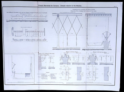
1856 Capt Delafield Large Antique Schematics of French Calvary Barracks, Stables
Antique Map
- Title : French Barracks for Cavalry - Details relative to the Stables
- Date : 1856
- Condition: (A) Very Good Condition
- Ref: 90125
- Size: 26in x 20in (660mm x 500mm)
Description:
This large original lithograph print, internal schematics of the French Cavalry Barracks & Stables - during the time of the Crimean War and just prior to the American Civil War - was engraved by John T Bowen & co. of Philadelphia and was published in the 1856 edition of Captain Richard Delafields Report on the Art of War in Europe in 1854, 1855, and 1856.
In early 1855, Captain Richard Delafield was appointed by the Secretary of War, Jefferson Davis, a head of the board of officers, later called The Delafield Commission, and sent to Europe to study the European military. The board included Captain George B. McClellan and Major Alfred Mordecai. They inspected the state of the military in Great Britain, Germany, the Austrian Empire, France, Belgium, and Russia, and served as military observers during the Crimean War. After his return in April 1856, Delafield submitted a report which was later published as a book by Congress, Report on the Art of War in Europe in 1854, 1855, and 1856. The book was suppressed during the American Civil War due to fears that it would be instructive to Confederate engineers as it contained multiple drawings and descriptions of military fortifications.
General Definitions:
Paper thickness and quality: - Light and stable
Paper color : - off white
Age of map color: -
Colors used: -
General color appearance: -
Paper size: - 26in x 20in (660mm x 500mm)
Plate size: - 26in x 20in (660mm x 500mm)
Margins: - Min 1/2in (12mm)
Imperfections:
Margins: - None
Plate area: - Light age toning along folds as issued
Verso: - Folds re-enforced with archival tape
Background:
The arrival of explosive shells in the 19th century led to yet another stage in the evolution of fortification. Star forts did not fare well against the effects of high explosive and the intricate arrangements of bastions, flanking batteries and the carefully constructed lines of fire for the defending cannon could be rapidly disrupted by explosive shells.
Worse, the large open ditches surrounding forts of this type were an integral part of the defensive scheme, as was the covered way at the edge of the counter scarp. The ditch was extremely vulnerable to bombardment with explosive shells.
In response, military engineers evolved the polygonal style of fortification. The ditch became deep and vertically sided, cut directly into the native rock or soil, laid out as a series of straight lines creating the central fortified area that gives this style of fortification its name.
Wide enough to be an impassable barrier for attacking troops, but narrow enough to be a difficult target for enemy shellfire, the ditch was swept by fire from defensive blockhouses set in the ditch as well as firing positions cut into the outer face of the ditch itself.
The profile of the fort became very low indeed, surrounded outside the ditch covered by caponiers by a gently sloping open area so as to eliminate possible cover for enemy forces, while the fort itself provided a minimal target for enemy fire. The entrypoint became a sunken gatehouse in the inner face of the ditch, reached by a curving ramp that gave access to the gate via a rolling bridge that could be withdrawn into the gatehouse.
Much of the fort moved underground. Deep passages and tunnels now connected the blockhouses and firing points in the ditch to the fort proper, with magazines and machine rooms deep under the surface. The guns, however, were often mounted in open emplacements and protected only by a parapet; both in order to keep a lower profile and also because experience with guns in closed casemates had seen them put out of action by rubble as their own casemates were collapsed around them.
Gone were citadels surrounding towns: forts were to be moved to the outside of the cities some 12 km to keep the enemy at a distance so their artillery could not bombard the city center. From now on a ring of forts were to be built at a spacing that would allow them to effectively cover the intervals between them.
The new forts abandoned the principle of the bastion, which had also been made obsolete by advances in arms. The outline was a much simplified polygon, surrounded by a ditch. These forts, built in masonry and shaped stone, were designed to shelter their garrison against bombardment. One organizing feature of the new system involved the construction of two defensive curtains: an outer line of forts, backed by an inner ring or line at critical points of terrain or junctions (see, for example, Séré de Rivières system in France).
Traditional fortification however continued to be applied by European armies engaged in warfare in colonies established in Africa against lightly armed attackers from amongst the indigenous population. A relatively small number of defenders in a fort impervious to primitive weaponry could hold out against high odds, the only constraint being the supply of ammunition.
Delafield, Richard Major General 1798 - 1873 - Delafield was a United States Army officer for 52 years. He served as superintendent of the United States Military Academy for 12 years. At the start of the American Civil War, then Colonel Delafield helped equip and send volunteers from New York to the Union Army. He also was in command of defences around New York harbor from 1861 to April 1864. On April 22, 1864, he was promoted to Brigadier General in the Regular Army of the United States and Chief of Engineers. On March 8, 1866, President Andrew Johnson nominated Delafield for appointment to the grade of brevet major general in the Regular Army, to rank from March 13, 1865, and the United States Senate confirmed the appointment on May 4, 1866, reconfirmed due to a technicality on July 14, 1866. He retired from the US Army on August 8, 1866. He later served on two commissions relating to improvements to Boston Harbor and to lighthouses. He also served as a regent of the Smithsonian Institution.
Delafield served as assistant engineer in the construction of Hampton Roads defences from 1819–1824 and was in charge of fortifications and surveys in the Mississippi River delta area in 1824-1832. While superintendent of repair work on the Cumberland Road east of the Ohio River, he designed and built Dunlaps Creek Bridge in Brownsville, Pennsylvania, the first cast-iron tubular-arch bridge in the United States. Commissioned a major of engineers in July 1838, he was appointed superintendent of the Military Academy after the fire of 1838 and served till 1845. He designed the new buildings and the new cadet uniform that first displayed the castle insignia. He superintended the construction of coast defences for New York Harbor from 1846 to 1855.
In the beginning of 1855, Delafield was appointed by the Secretary of War, Jefferson Davis a head of the board of officers, later called The Delafield Commission, and sent to Europe to study the European military. The board included Captain George B. McClellan and Major Alfred Mordecai. They inspected the state of the military in Great Britain, Germany, the Austrian Empire, France, Belgium, and Russia, and served as military observers during the Crimean War. After his return in April 1856, Delafield submitted a report which was later published as a book by Congress, Report on the Art of War in Europe in 1854, 1855, and 1856. The book was suppressed during the American Civil War due to fears that it would be instructive to Confederate engineers as it contained multiple drawings and descriptions of military fortifications.
Delafield served as superintendent of the Military Academy again in 1856-1861. In January 1861, he was succeeded by Captain Pierre G. T. Beauregard, who was dismissed shortly after Beauregards home state of Louisiana seceded from the Union, and Delafield returned as superintendent serving until March 1, 1861. In the beginning of the Civil War he advised the governor of New York Edwin D. Morgan during the volunteer force creation. Then, in 1861–1864, he was put in charge of New York Harbor defences, including Governors Island and Fort at Sandy Hook. On May 19, 1864, he was commissioned a brigadier-general after replacing Joseph Gilbert Totten, who had died, as the Chief of Engineers, United States Army Corps of Engineers, on April 22, 1864. He stayed in charge of the Bureau of Engineers of the War Department until his retirement on August 8, 1866. On March 8, 1866, President Andrew Johnson nominated Delafield for appointment to the grade of brevet major general in the Regular Army of the United States, to rank from March 13, 1865, and the United States Senate confirmed the appointment on May 4, 1866 and reconfirmed it due to a technicality on July 14, 1866.After retirement Delafield served as a regent of the Smithsonian Institution and a member of the Lighthouse Board. He died in Washington, D.C. on November 5, 1873.
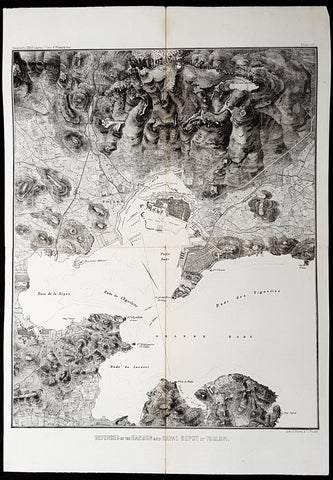
1856 Capt. Richard Delafield Antique Map City & Naval Defenses of Toulon, France
Antique Map
- Title : Defenses of the Harbor and Naval Depot at Toulon
- Ref #: 90127
- Size: 22in x 15in (560mm x 385mm)
- Date : 1856
- Condition: (A) Very Good Condition
Description:
This large original lithograph map of the city and naval defenses of Toulon, France was engraved by John T Bowen & co. of Philadelphia and was published in the 1856 edition of Captain Richard Delafields Report on the Art of War in Europe in 1854, 1855, and 1856.
General Definitions:
Paper thickness and quality: - Heavy and stable
Paper color : - off white
Age of map color: -
Colors used: -
General color appearance: -
Paper size: - 22in x 15in (560mm x 385mm)
Plate size: - 22in x 15in (560mm x 385mm)
Margins: - Min 1in (25mm)
Imperfections:
Margins: - None
Plate area: - Llight age toning along folds as issued
Verso: - Folds re-enforced with archival tape
Background:
In the beginning of 1855, Captain Richard Delafield was appointed by the Secretary of War, Jefferson Davis, a head of the board of officers, later called The Delafield Commission, and sent to Europe to study the European military. The board included Captain George B. McClellan and Major Alfred Mordecai. They inspected the state of the military in Great Britain, Germany, the Austrian Empire, France, Belgium, and Russia, and served as military observers during the Crimean War. After his return in April 1856, Delafield submitted a report which was later published as a book by Congress, Report on the Art of War in Europe in 1854, 1855, and 1856. The book was suppressed during the American Civil War due to fears that it would be instructive to Confederate engineers as it contained multiple drawings and descriptions of military fortifications.
Delafield, Richard Major General 1798 - 1873
Delafield was a United States Army officer for 52 years. He served as superintendent of the United States Military Academy for 12 years. At the start of the American Civil War, then Colonel Delafield helped equip and send volunteers from New York to the Union Army. He also was in command of defences around New York harbor from 1861 to April 1864. On April 22, 1864, he was promoted to Brigadier General in the Regular Army of the United States and Chief of Engineers. On March 8, 1866, President Andrew Johnson nominated Delafield for appointment to the grade of brevet major general in the Regular Army, to rank from March 13, 1865, and the United States Senate confirmed the appointment on May 4, 1866, reconfirmed due to a technicality on July 14, 1866. He retired from the US Army on August 8, 1866. He later served on two commissions relating to improvements to Boston Harbor and to lighthouses. He also served as a regent of the Smithsonian Institution.
Delafield served as assistant engineer in the construction of Hampton Roads defences from 1819–1824 and was in charge of fortifications and surveys in the Mississippi River delta area in 1824-1832. While superintendent of repair work on the Cumberland Road east of the Ohio River, he designed and built Dunlaps Creek Bridge in Brownsville, Pennsylvania, the first cast-iron tubular-arch bridge in the United States. Commissioned a major of engineers in July 1838, he was appointed superintendent of the Military Academy after the fire of 1838 and served till 1845. He designed the new buildings and the new cadet uniform that first displayed the castle insignia. He superintended the construction of coast defences for New York Harbor from 1846 to 1855.
In the beginning of 1855, Delafield was appointed by the Secretary of War, Jefferson Davis a head of the board of officers, later called The Delafield Commission, and sent to Europe to study the European military. The board included Captain George B. McClellan and Major Alfred Mordecai. They inspected the state of the military in Great Britain, Germany, the Austrian Empire, France, Belgium, and Russia, and served as military observers during the Crimean War. After his return in April 1856, Delafield submitted a report which was later published as a book by Congress, Report on the Art of War in Europe in 1854, 1855, and 1856. The book was suppressed during the American Civil War due to fears that it would be instructive to Confederate engineers as it contained multiple drawings and descriptions of military fortifications.
Delafield served as superintendent of the Military Academy again in 1856-1861. In January 1861, he was succeeded by Captain Pierre G. T. Beauregard, who was dismissed shortly after Beauregards home state of Louisiana seceded from the Union, and Delafield returned as superintendent serving until March 1, 1861. In the beginning of the Civil War he advised the governor of New York Edwin D. Morgan during the volunteer force creation. Then, in 1861–1864, he was put in charge of New York Harbor defences, including Governors Island and Fort at Sandy Hook. On May 19, 1864, he was commissioned a brigadier-general after replacing Joseph Gilbert Totten, who had died, as the Chief of Engineers, United States Army Corps of Engineers, on April 22, 1864. He stayed in charge of the Bureau of Engineers of the War Department until his retirement on August 8, 1866. On March 8, 1866, President Andrew Johnson nominated Delafield for appointment to the grade of brevet major general in the Regular Army of the United States, to rank from March 13, 1865, and the United States Senate confirmed the appointment on May 4, 1866 and reconfirmed it due to a technicality on July 14, 1866.After retirement Delafield served as a regent of the Smithsonian Institution and a member of the Lighthouse Board. He died in Washington, D.C. on November 5, 1873.
1857 Dufour Very Large Scarce Old, Antique Map of France - 4ft x 6ft
- Title : Carte Administrative et Physique de la France indiquant Les Canaan Les Riviers Navigable les routes, le Chemis de fer avec leurs stations Dresee par A.H. Dufour Gravee Par CH Dyonnet 1857
- Ref #: 61029
- Size: 62in x 46in (1.5m x 1.15m)
- Date : 1857
- Condition: (A) Very Good Condition
Description:
This scarce very large elephant folio 4 sheet - joined - hand coloured original map of France was engraved by Charles Dyonnet in 1857 - dated in the title - for Adolphe Hippolyte Dufour's monumental elephant folio Atlas Physique, Historique et Politique Geographie Moderne published by Pauline Et La Chevalier, Paris.
This uncommon elephant folio map is huge measuring overall 62in x 46in (1.5m x 1.15m) and is incredibly detailed. The map covers the whole of France including Corsica and parts of Spain, Germany and Switzerland.
The first sheet (top left in image) represents north-western France and includes two insets of Nantes and Rouen. The second sheet (top right) represents north-eastern France with an inset of Paris and its environs. The bottom right sheet depicts the south-eastern portions of France and includes two insets, one featuring Marseille and the other featuring Lyon. The last sheet on the bottom left is of southwest France.
An inset on Bordeaux is included and throughout illustrates roads, canals, railways, rivers, cities and other topographical features are noted.
Adolphe Hippolyte Dufour (1795 - 1865), also known as Auguste-Henri Dufour, was a Paris based map and atlas publisher active in the middle to late 19th century. Dufour claimed to be a student of another French cartographer, Emile Lapie. He is known to have worked with numerous other cartographers, publishers and engravers of the period including Charles Dyonnet and Duvotenay. His corpus includes numerous maps and atlases, the most striking of which is probably his monumental elephant folio Atlas Universel physique, historique et politique geographie ancienne et moderne. Dufour's student and successor was Alexandre Vuillemin.
Charles Dyonnet (fl. c. 1822 - c. 1880) was an extremely active Paris based engraver working in the mid to late 19th century. From his offices at 220 Rue St. Jacques, Paris, Dyonnet engraved numerous maps for many of the most prominent 19th French cartographic publishers including Vuillemin, Dufour, Fremin and Duvotenay. From 1850-1861, he held the coveted position of "Graveur du Dépot de la Marine," and in this position engraved numerous French naval and military maps. Dyonnet had a detail oriented and aesthetically minded hand and is responsible from some of the most beautiful French maps to emerge during the 19th century. (Ref: M&B; Tooley)
General Description:
Paper thickness and quality: - Heavy & stable
Paper color: - White
Age of map color: - Original
Colors used: - Yellow, red, green, blue
General color appearance: - Authentic
Paper size: - 62in x 46in (1.5m x 1.15m)
Paper size: - 62in x 46in (1.5m x 1.15m)
Margins: - Min 1in (24mm)
Imperfections:
Margins: - None
Plate area: - Top NE sheet age toning
Verso: - Soiling